
ABSTRACT
The current study's objectives are to identify the primary source rock's hydrocarbon potential and, using various approaches, examine the Sallum Concession's petroleum system, which lies in the extreme northwestern part of the Western Desert of Egypt. We integrated seismic, geochemical, and well logging data. As a result, the structure analysis indicates that the area is elevated topographic land, representing a high intra-basin about the surrounding Faghour, Matrouh, and Shushan basins. Therefore, the site is a significant concession with various source rocks; Khatatba (Safa member) and Alam El-Buieb (AEB-3A member) are the oil-prone source rocks of the northern and southern parts of the area with high TOC (up to 11.3%) and mid-mature stage (0.7-1.0% Ro) at depth below 8000 ft. On the other hand, the Paleozoic Desouqy, Zeitoun, and Shiffah formations, located below 12000 ft, are gas-prone source rocks with high organic contents (TOC 1.41-4.64%) and fair potential for gas generation and are currently in the mid-mature stage (0.7-1.0% Ro). We concluded that the concession's low oil production might result from a delay in Kerogen maturity and hydrocarbon migration. Finally, the East of Sallum concession is the only potential area because the wells in the west do not show reservoirs characteristics.
1. Introduction
Massive exploration and development potential may result from identifying petroleum system components and processes in sedimentary basins (Magoon and Dow Citation1994). When evaluating a reservoir, petrophysical analysis utilising wireline logs is crucial for differentiating between productive and non-productive bearing zones (e.g. Ellis and Singer Citation2007; Cannon Citation2015; Abdel-Fattah et al. Citation2019; El-Dakak et al. Citation2021). Additionally, the gamma-ray log pattern can reveal the depositional environment and sequences (e.g. Kadkhodaie and Rezaee Citation2017). In source rock evaluation, determining the source rock, its yield, and the degree of thermal maturity of the total organic matter are necessary for calculating the amount of generated hydrocarbon in a basin or prospect (Meyer and Nederlof Citation1984). The type of organic materials in the source rocks also affects the composition of the hydrocarbons. Therefore, determining the type and amount of organic matter in the sedimentary source rocks is crucial since it will lighten the evolution of the paleo-environment and basins. Typically, chemical and microscopic analyses of rock samples are used in laboratories to assess the kind, quantity, and maturity of organic materials in source rocks (Zhao et al. Citation2016, Citation2017).
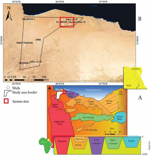
The sedimentary cover of the Western desert is part of the foreland deposits that fringe the Afro-Arabian shield’s northern continental margin from the Western Desert’s southernmost area (El Gezeery et al. Citation1972). The exposed Pre-Palaeozoic basement exhibits a regional northward slope, while the overlaid sedimentary cover, composed of Palaeozoic, Mesozoic, and Tertiary to Recent rock groups, thickens in accordance. According to Dolson et al. (Citation2002) research of more than 300 wells in the northern Western Desert, this region of the Western Desert could be divided into five primary sedimentary basins (). The Gindi, Natrun, Abu Gharadig, Palaeozoic, and Northern basins are among them. The study area named Sallum Concession lies at the northwestern edge of the Western Desert of Egypt. It is represented by an intra-basin between the Matruh Basin and Faghur Plateau, with an area of about 5498.35 km2. The Mediterranean shoreline bounds it to the north, adjacent to the Libyan Border and west of West Obaiyed, Khalda Offset, West Kalabsha concessions, and several rock units with fair to good potential for hydrocarbon generation and accumulation ().
Figure 1. A) Northwestern sedimentary basins (Dolson et al. Citation2002). B) Location map of the Sallum Concession and available well data.
This study aims to assess the petroleum system elements in the Sallum intra-basin in terms of source rock potentiality, maturation, migration, reservoir quality, and trapping styles. We used wireline logs, seismic, geochemical data to evaluate the source rock’s total organic carbon (TOC), its maturity, and migration pathways and delineate the best reservoir zones in the sedimentary succession. Although there have been a number of oil and gas discoveries along the Sallum Concession, nothing is known about the whole model for the petroleum geology characteristics, which prompted us to look into more existing petroleum systems. We examined the source rock’s thermal maturity and burial history and assessed the field reservoirs’ hydrocarbon potential. Additionally, we have also researched the overall petroleum system and the sequence stratigraphy, both of which can aid in field development.
2. Regional geology of western desert
2.1. Stratigraphy and depositional environments
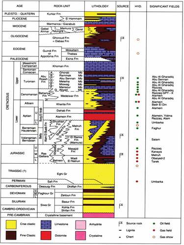
The sedimentary section of the northern part of the Western Desert has sediments ranging from Lower Palaeozoic to Recent (). The shifting of depocentres in a consistently subsiding area such as the Western Desert has produced a wide range of sedimentary environments. Many of these settings provide favourable conditions for hydrocarbon generation and entrapment (Keeley Citation1989; Diab and Khalil Citation2021). The early Jurassic Bahrein Formation, a continental sequence, was the first Mesozoic deposit in the Western Desert. During the Middle Jurassic, shallow marine deposits developed next. The Eastern Gindi Basin is mostly an Eocene Basin. The northeastern Natrun Basin is primarily a Jurassic Basin. The majority of the southern Abu Gharadig Basin originates from the Late Cretaceous (Felestteen et al. Citation2014). The Lower Cretaceous clastic sequences record a transgressive marine cycle – a relative sea level rise and subsequent fall. Fluvio-continental sediments from the Neocomain period form the basis of this cycle, followed by transitional, near-shore, deltaic sediments from the Lower Aptian and Albian periods. Alamein Carbonates were deposited in a constrained marine/lagoonal environment, so the transgression peaked during the Middle and Upper Aptian. The cycle was completed at the end of the Lower Cretaceous (Upper Albian to Lower Cenomanian) by a return to continental deposits, followed by a carbonate platform that dominated the Tertiary sedimentation, representing relatively stable conditions. The Formations included in this genetic unit are the Apollonia, Dabaa, Mamura/Moghra, and Marmarica. The petroleum significance of the Tertiary Platform sediments is their contribution to the overburden (Moustafa Citation2020).
Figure 2. The generalised stratigraphic column of Northern Western Desert (EGPC Citation1992).
2.2. Structural setting
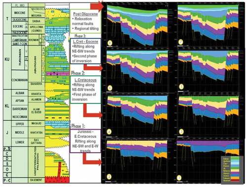
The main segment of the Central African rift system is linked to thick Mesozoic-Cenozoic sedimentary sections that have accumulated in Western Desert basins (Guiraud et al. Citation2005). Three major phases of deformation are inferred from the detailed surface and subsurface geological evidence of Mesozoic-Cenozoic rocks in Egypt’s North-WD, structural evolution, and basin configuration. Rift basins are opened by extensional deformation, and some are closed by compressional deformation (Mahmoud et al. Citation2019) (). The first Jurassic rifting event was developed along NNE-SSW normal fault trends. The observed changes in Jurassic thickness along these fault trends support this. But because of the Lower Cretaceous rifting, normal faults with WNW-ESE and NW-SE orientations have formed where Cretaceous rocks thicken against them.
Figure 3. Restored cross-sections summarised the tectonic movement from the Jurassic to Recent in the Northern Western Desert (Mahmoud et al. Citation2019).
On the other hand, the Matruh and Shushan basins exhibit uniformly thick Upper Cretaceous strata. This demonstrates unequivocally that NW-SE and WNW-ESE-oriented faults affected the region where the post-Jurassic rifting occurred mainly during the Early Cretaceous. These two Jurassic and Cretaceous rifting episodes are thought to have involved the Northern Western Desert in two separate directions (Sayed et al. Citation2020; El Shaarawy and Haggag Citation1990). The second tectonic event is the Late Cretaceous Turonian-Senonian. The movement along the previously existing NNE-SSW was reversed due to this occurrence. The paleo structural lows were inverted by Jurassic normal fault trends, creating asymmetric folds. The main basin-bounding faults typically split the asymmetric folds’ steep flank and exhibit reverse slip. At the level of the Upper Cretaceous rocks, reverse slide on these faults is evident, although, at deeper Jurassic levels, it is a common occurrence (Shalaby et al. Citation2013; El Gazzar et al. Citation2016). The third tectonic event is the Miocene and post-Miocene extension. Following the Late Cretaceous-Early Tertiary basin inversion, Early Miocene deformation impacts the West Obaiyed’s Eocene (Apollonia Fm) and Oligocene sediments. During this phase, the NW-SE normal fault formed.
3. Materials and methods
This study used wireline logs from 8 wells () to identify reservoir zones and to estimate different petrophyscial parameters. In addition, we employed basin modelling software to simulate the basin’s burial history and thermal maturity (Maleki et al. Citation2021). In this study, we used two sets of seismic data available, 2D seismic lines in the northern and central parts of the concession, 3D seismic in the northeastern corner of the concession.
Table 1. The wells used in this study and its targets.
Three main processes were used to analyse the available log data. First, a qualitative correlation between the wells in the research region to gather more specific data on the lateral continuity of interest zones. Second, the petrophysical characteristics of the encountered reservoir rocks, including net pay thickness, shale volume, porosity, permeability, hydrocarbon saturation, and all other factors. These characteristics are used to quantify the amount of hydrocarbon in a reservoir and discriminate among hydrocarbon and non-hydrocarbon-bearing zones (Schlumberger Citation1974). Finally, a set of iso-parametric maps was created to delineate fluid saturation and rock parameters lateral variations. We primarily use the reservoir parameter maps of the interest units to fully understand the hydrocarbon potentiality and identify the places where hydrocarbon accumulation is most likely to occur.
The Rock-Eval pyrolysis analysis was carried out on three wells in the area of study, namely Fagour-1, El-Noor-1, and Halfiya-1. Five hundred and eighteen (518) samples () were selected from the regions with inadequate coverage or when the existing data were considered poor quality. The investigation comprised Total Organic Carbon (TOC) determination, Rock-Eval pyrolysis, detailed microscopic examination, and vitrinite reflectance (% Ro) measurements. We estimated the burial history of the basin depending on the thickness, depth, and temperature of each rock unit. The deposition history and temperature vs. depth are commonly shown in the thermal model of lithologies, which is calibrated using vitrinite reflectance (Ro).
Table 2. Number of samples used in source rock evaluation.
4. Results
4.1. Seismic data interpretation
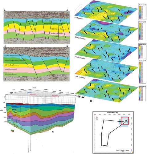
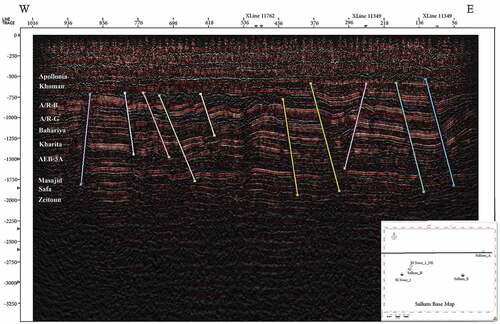
Fault and horizon interpretation was performed for Top Abou Roash “B” Member (Late Cretaceous-Coniacian), Top Bahariya Formation (Late Cretaceous-Cenomanian), Top Alam El-Boub-3A Member (AEB-3A) (Early Cretaceous), Top Masajed Formation (Late-Jurassic), and Safa Member (Middle-Jurassic). We used the seismic structure attribute for better data analysis (Chopra and Marfurt Citation2007) and extracted the velocity model from the logging data. To provide the highest level of structure map quality, fault throws and throw direction sign convention were carefully examined (). We found that, the area is divided by normal faults with distinct throw directions along the NW-SE and WNW-ESE, according to the depth structure contour maps of the examined reflectors (). Therefore, it might be connected to this early Cretaceous extensional phase, which included a widespread tilt towards the northeast. To explain the subsurface structure in the area and show the main change in depositional thickness, two cross-sections are chosen: the N-S crossline direction and the E-W inline direction (), depth contour maps (), and geological model created from structure and stratigraphy features from seismic and well data () were integrated to get better understand for the area structure. The studied area is typically faulted and significantly elevated during the compressional event phase. These faults produced an intra-graben structure with a dip direction to the south.
Figure 4. The main pre geological model steps, A) is the arbitrary line through the drilled wells at the eastern part to show the subsurface structure main settings, B) E-W crossline with main interpretation targets, C) N-S inline, D) Final TWT five maps, E) Average pseudo velocity values created from VSP with seismic data to create the depth maps.
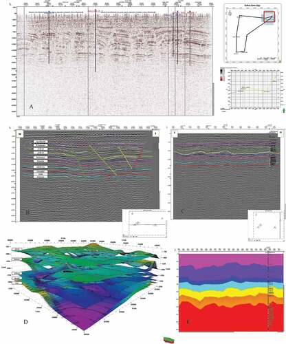
Figure 5. A) Two cross-sections are chosen: the N-S crossline direction and the E-W inline direction, B) depth contour maps, and C) geological model created from structure and stratigraphy features from seismic and well data.
4.2. Petrophysical analysis
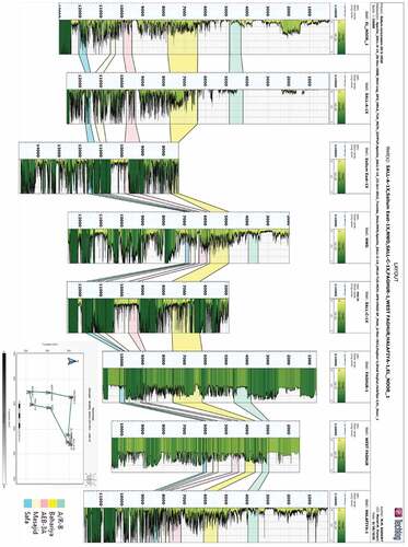
To better understand reservoir details, facies variation, fluid content, subsurface structure, and reservoir heterogeneity, well data analysis procedures were carried out on the interesting intervals of the Abu Roash “B” Member, Bahariya, AEB-3A Member, and Safa formations for the available wells (El-Noor-1, Sallum East-1X, Halafiya-1, Faghour-1, Sall-A-1X, NWD, and Sall-C-1X). The results () are mapped (), and a correlation between the wells was performed () to know the relation between the wells from the structural point of view. The results of the petrophysical analysis indicate that the primary reservoir objectives are the AEB-3A and Safa member sandstones. The AEB-3A reservoir of the Sallum area is comprised of fluvial and shallow marine sands interbedded with marine shales and carbonates, showing an increasing maritime influence on the north in the Sallum area. Despite the overall reduced net to gross of the AEB intervals, thin stacked sandstone reservoirs are still present and provide a valid exploration target. The intraformational shales, silt, and limestone of the AEB provide the top and lateral seal for the AEB reservoir. The Safa Member of the Khatatba Formation is deposited in a deltaic to a fluvial environment dominated by shales and coals with minor sands around El-Noor-1 well to Sallum East-1X. With increasing carbonate content, this environment becomes more marine to the north towards the Sall-A-1X well. The amount of sand present will depend on proximity to fluvial channels and possible variance. The Safa member in the El-Noor-1 well consists of stacked, clean fluvio-deltaic sands with minor marine influence grading to a marginal marine setting at the top of the unit. The massive limestone of the higher Khatatba and Masajid formations will be deposited at the end of the late Callovian-Oxfordian transgression, and the shales will provide the top and lateral seal. The Northeastern Sallum concession contains the lowest shaly zones, highest porosity, and most significant thickness, according to the principal petrophysical analysis using well log interpretation (). Faghour-1, West Faghour, and Halafiya-1, three wells drilled in the west, show minimal to non-reservoir petrophysical properties, suggesting that the east portion of Sallum concession is the preferable location for hydrocarbon exploration in the study region.
Table 3. The resulted petrophysical parameters for the potential reservoirs.
Figure 6. The petrophysical parameters maps for AEB-3A reservoir and Safa reservoir, showing the distribution of shale volume (Vsh %), effective porosity (Eff Ф %), and water saturation (Sw %).
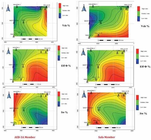
Figure 7. Wells correlation for the interested interpreted horizons based on the calculated shale volume.
4.3. Source rock potential
In Sallum East Concession, generation of only minor amounts of hydrocarbons would be expected from the Alam El Bueib source. Khatatba source rocks have started expelling hydrocarbons from about 25–70 Ma. The Carboniferous, Devonian, and Silurian source rocks began hydrocarbon expulsion, in the northern part of the study area, from ~20–30 Ma., Alam El Bueib source rocks with thicknesses ranging between 10 and 70 ft are mainly encountered in Sallum East Concession. These rocks are generally characterised by high organic contents and fair to excellent potential to generate mostly gas with some oil. The Khatatba Formation appears in the mid-mature stage in the Sallum East-1, El Noor-1, and is immature-early mature in other areas. The Carboniferous source rocks are encountered in most wells drilled near the Egyptian-Libyan Border. The encountered thickness of the Carboniferous source rocks significantly varies throughout the study area, and the most significant source rock thickness is seen in Sallum E-1 well. There is a general increase in the maturity of Carboniferous rocks towards the North, where the highest maturity values are recorded in the well Halafaya-1 (the end of the Mid-mature stage). In the study area, the Devonian Zeitoun source rocks generally have high organic contents and fair to good hydrocarbon generating potential. The Zeitoun source rocks appear to have different facies and thicknesses throughout the study area. Therefore, gas-prone rocks are encountered in the wells Halafya-1 and Faghur-1, while mixed oil and gas-prone source rocks are seen in other wells. The Silurian source rocks are only encountered in a thin interval in the Sallum East Concession. These rocks have high organic content and fair potential to generate oil and gas ().
Table 4. Source rock evaluation in the Sallum Concession.
From the burial history modelling (), in the El-Noor-1 well, Khatatba appears to be in a mid-mature stage from 0.8% to 1.0% Ro. The presence of Jurassic sub-basins in the northern part of Sallum Concession to the west of EL_NOOR_1 indicates the possible hydrocarbon generation and migration from the west. However, while shows have been documented in the wells drilled within the Sallum concession, the Jurassic source rock has yet to be proven to be of sufficient quality and generate the potential to supply significant charge to the mapped structures. The shales of the Lower AEB may also be relatively rich in organic material; however, they are unlikely to be buried to a sufficient depth to be generating hydrocarbons (). In the northeastern part of Sallum East Concession (El-Noor-1 well), the modelling results indicate that Alam El Bueib and Khatatba source rocks, where encountered, are primarily in the mid-mature stage (0.7–1.0% Ro). Therefore, based on the expulsion models of these wells, only the generation of minor amounts of hydrocarbons from Alam El Bueib source rocks would be expected. On the other hand, the Khatatba source rocks appear to have started expelling hydrocarbons from about 25–20 Ma, and about 140–160 barrels/acre*ft of hydrocarbons could have been expelled.
Figure 8. The burial history charts calibrated with the vitrinite reflectance Ro for the well Fagour-1, El-Noor-1, and Halafiya-1.
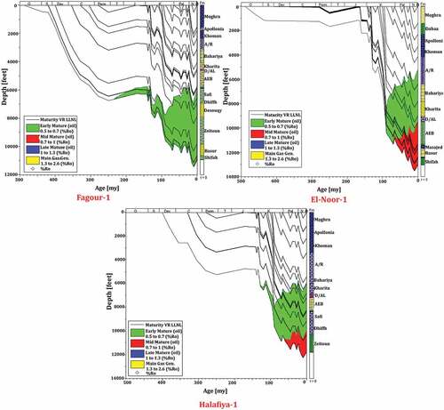
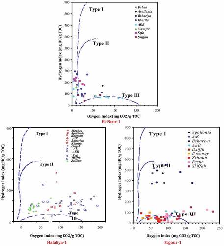
Figure 9. The diagram of Hydrogen Index (HI) vs. Oxygen Index (OI) based on Rock-Eval pyrolysis, describing the type of organic matter in the Sallum Concession for the wells Fagour-1, El-Noor-1, and Halafiya-1.
In the southern part of Sallum East Concession from Faghour-1, the penetrated sections are currently in the immature to the early mature stage (<0.70% Ro) and, therefore, generation of only minor amounts of hydrocarbons could have possibly occurred. On the other hand, in the western part of Sallum East Concession, the modelling of Halfayia-1 well shows that the Alam El Bueib Formation unconformably overlies the Carboniferous sediments. The Alam El Bueib sediments are primarily in the early mature stage (0.5–0.7% Ro). With such low maturity, the only generation of minor amounts of hydrocarbons from the Alam El Bueib and older source rocks would be expected, and no hydrocarbon expulsion could have possibly occurred.
5. El Noor-1
Two primary source rock types could be distinguished in the analysed section. The rocks at 7900 fet and 8910–8950 ft from the Kharita Formation, 10,956 ft from the AEB Formation, and 11,950–12,000 ft and 11,730–11,761 ft from the U. Safa Member are mixed oil/gas-prone (). These rocks have a high to very high TOC (1.11–11.30%) and a fair to excellent potential to generate oil and gas (pyrolysis S2 yields 2.39–33.54 mg/g), as shown by their moderate hydrogen indices (mostly 211–297). On the other hand, the second source rock type is mainly gas-prone and represents rocks from the Kharita, AEB, and U. Safa intervals. These rocks have high to very high TOC values (1.63–4.46%) and fair to good potential (pyrolysis S2 yields 2.24–8.06 mg/g and H.I. mostly <184) to generate mainly gas at maturity. In addition, elevated Pyrolysis S1 values (S1 mostly >0.5 mg/g) are encountered in localised intervals within the Kharita, Alam El Bueib, and U. Safa intervals, which suggest the presence of free hydrocarbons ().
Figure 10. The Geochemical log plotted from the Rock-Eval Pyrolysis analysis of the well El-Noor-1, showing the TOC richness and maturity.
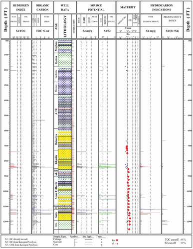
Evaluation of maturity for the section penetrated in El Noor-1 well was based on the vitrinite reflectance (Ro) measurements from the Robertson Study (Old Data). Calculated Ro maturities were available for twenty-five samples from El Noor-1 well in the interval 7500–13,018 ft. The Ro values show a general increase with depth from 0.53% Ro at 7500 ft to 0.76% Ro at 13,018 ft. The maturity profile based on these results suggests that the top of the oil window could be encountered at about 8000 ft (). Based on these results, the Upper Cretaceous and younger section are thermally immature, while the Lower Cretaceous and older sediments are currently in the oil window.
6. Faghur-1 well
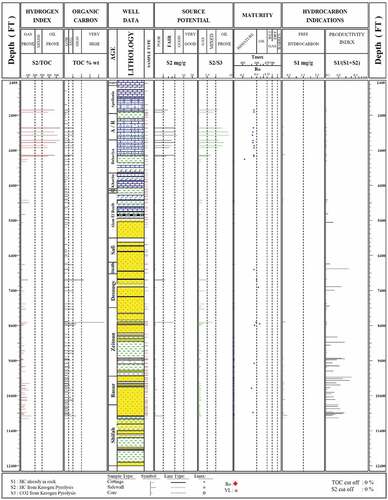
The screening analysis (TOC and Rock-Eval Pyrolysis) results revealed the presence of two source rock types. The First source rock type is oil-prone and is mainly represented by the rocks within the Apollonia Formation (2220–2310 ft), Abu Roash Formation (2730–2970 ft), and Bahariya Formation (3090–3570 ft). These rocks have average to high organic contents (TOC 0.59–1.12%) () and are characterised by fair to good hydrocarbon generating potential (pyrolysis S2 yields 2.24–5.78 mg HC/g rock). Hydrogen Indices are generally high (369–549 mg HC/g TOC), indicating the presence of good quality kerogen capable of generating oil at maturity. The second type is gas prone and is encountered in localised intervals below 5900 ft (Palaeozoic section) and appears common within the Desouqy Formation in the interval 7090–7100 ft, and is also encountered within the Zeitoun Formation in the interval 8300–8310 ft and Shiffah Formation in the interval 10,970–10,980 ft. These rocks generally have high organic contents (TOC 1.41–4.64%) and fair potential for gas generation (pyrolysis S2 yields 2.10–4.46 mg/g and HI 96–149). Evaluation of the thermal maturity of the analysed section in the Faghur-1 well is based only on the Pyrolysis Tmax results. Pyrolysis Tmax values, which mostly range from 428°C at 2220 ft to 448oC at 8350 ft (), indicate that the penetrated section in the Faghur-1 well is thermally immature down to 6500 ft. Below this depth, the sediments are probably in the oil window (defined by 0.6% Ro).
Figure 11. The Geochemical log plotted from the Rock-Eval Pyrolysis analysis of the well Fagour-1, showing the TOC richness and maturity.
7. Halfaya-1
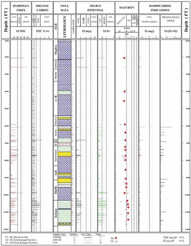
The TOC and Rock-Eval Pyrolysis results revealed the presence of two primary source
rock types: The first source rock type is mainly oil-prone and is encountered in localised intervals within the Apollonia, Dhiffah, and Zeitoun formations 2050–2600 ft, 9890–9900 ft, 10,540–10,550 ft, 11,050–11,060 ft, and 11,710–11,720 ft (). These rocks have average to very high organic contents (TOC 0.59–2.48%) and fair to good potential for oil generation at maturity (pyrolysis S2 yields 3.17–9.38 mg HC/g rock, and HI 313–975 mg HC/g TOC). The second source rock type is mainly gas prone and appears common in Zeitoun Formation 10,340–10,350 ft, 10,440–10,450 ft, 10,590–10,730 ft, and 11,120–11,130 ft and localised intervals in Dahab (6820–6830 ft) and Alam El Bueib (7700–7710 ft) formations. These rocks generally have high organic contents (TOC 1.28–2.35%) and fair potential for gas generation (pyrolysis S2 yields 2.09–4.96 mg HC/g rock and HI 115–211 mg HC/g TOC). The calculated Ro maturities are based on the best quality measurements and generally increase with increasing burial. The maturity profile based on the most reliable vitrinite reflectance data locates the top of the oil window (defined by 0.6%Ro) at approximately 8500 ft.
Figure 12. The Geochemical log plotted from the Rock-Eval Pyrolysis analysis of the well Halafiya-1, showing the TOC richness and maturity.
8. Discussion
8.1. Source rocks
The petroleum system elements in the Sallum Concession were discussed based on previous petrophysical, Geochemical, structural, and source rock analyses. The burial history, TOC, and Rock-Eval Pyrolysis analysis revealed the presence of two source rock types, oil-prone, and gas-prone source rocks. The first type is represented mainly by Apollonia, Abu Roash, and Baharyia formations within the depth interval above 5900 ft. It has average to high organic contents (TOC 0.59–11.3%) and is characterised by fair to good hydrocarbon generating potential (pyrolysis S2 yields 2.24–33.54 mg HC/g rock). In addition, hydrogen Indices are generally high (211–549 mg HC/g TOC), indicating the presence of good quality kerogen capable of generating oil at maturity. The second type of source rocks is usually encountered in the Palaeozoic section below 6000 ft and is represented mostly in Desouqy, Zeitoun, and Shiffah formations. These rocks generally have high organic contents (TOC 1.41–4.64%) and fair potential for gas generation (pyrolysis S2 yields 2.10–8.06 mg/g and HI 96–211).
The modelling results in the northeastern part of Sallum Concession (El-Noor-1 well and Sallum East-1X well) indicate that Alam El Bueib and Khatatba source rocks, where encountered, are primarily in the mid-mature stage (0.7–1.0% Ro). Also, only the generation of minor amounts of hydrocarbons from Alam El Bueib source rocks would be expected. On the other hand, the Khatatba source rocks appear to have started expelling hydrocarbons from about 25–20 Ma, and about 140–160 barrels/acre*ft of hydrocarbons could have been expelled. In the western part of Sallum Concession (Halfaya-1), The Alam El Bueib sediments are primarily in the early mature stage (0.5–0.7% Ro), while the Devonian and older deposits are currently in the mid mature stage (0.7–1.0% Ro). With such low maturity, only generation of minor amounts of hydrocarbons from the Alam El Bueib and older source rocks would be expected, and no hydrocarbon expulsion could have possibly occurred. Finally, in the southern part of Sallum Concession (Faghour-1 well), the penetrated sections are currently in the immature to the early mature stage (<0.70%Ro). Therefore, the generation of only minor amounts of hydrocarbons could have possibly occurred.
8.2. Reservoir rocks and sealing
The primary reservoir facies in the area are the early Cretaceous Alam El-Boub-3A Member (AEB-3A) and Middle Jurassic Safa Member. The top and lateral seals for the AEB reservoir are provided by the intraformational shales, silt, and limestone of the AEB. On the other hand, the enormous limestone and shales of the higher Khatatba and Masajid formations, deposited at the peak of the late Callovian – Oxfordian transgression would serve as the top and lateral seal. The Northeastern Sallum concession features the lowest shale zones, the highest porosity, and the greatest thickness, according to the major petrophysical analysis from well log interpretation. Drilling the wells, Faghour-1, West Faghour, and Halafiya-1 in the west exhibit minimal to non-reservoir petrophysical features, suggesting that the Sallum concession’s eastern section is the ideal location for hydrocarbon development in the study region.
8.3. Entrapping and migration pathways
According to the seismic data interpretation and the resulted depth maps, the most popular trapping style in the area is three-way closures due to the faulting process. The Sallum Concession area is generally higher than the surrounding basins, such as Faghour Basin to the west and Matrouh and Shushan basins to the northeast and east. This height may be the cause of delay in the maturation and migration processes, which led to a reduction in the amount of produced oil from the area. Faults extended through the Palaeozoic and Cenozoic characterise mainly the area (), which may be the hydrocarbon pathways from the underlying source rocks to the reservoirs
Figure 13. Shows the values of seismic attributes of the reservoir and source rocks as the difference in density by the anomaly of reflectivity energy.
9. Conclusion
The present work provides an integrated study of seismic data interpretation, petrophysical analysis, and geochemical analysis. The study area is the Sallum Concession, which lies between Faghour Basin to the west and Matrouh and Shushan basins in N.E. and E directions. The seismic data revealed that the area lies at a high elevation about the surrounding basins and folded in the Late Cretaceous Turonian-Senonian compression event. This fold faulted due to the Miocene and post-Miocene extension event, which caused an intra-graben structure with a dip direction to the south. Also, we used the wireline data to investigate the adequate reservoir facies in the sedimentary succession beneath the studied area. We found that the early Cretaceous Alam El-Boub-3A Member (AEB-3A) and Middle Jurassic Safa Member are the oil potential reservoirs and have an excellent regional seal used as vertical and side seals. Besides, we studied the TOC and Rock-Eval Pyrolysis results to determine the source rock potentiality and integrated the results with the burial and thermal models. As a result, we found that the oil produced from the area is generated from the Apollonia, Abu Roash, and Baharyia formations, while the gas generated from the Palaeozoic Desouqy, Zeitoun, and Shiffah formations, below 6000 ft. we concluded that the low amount of oil produced in the concession might be related to the delay in the Kerogen maturation and hydrocarbon migration because the area is high elevated about the surrounding.
Disclosure statement
No potential conflict of interest was reported by the authors.
References
- Abdel-Fattah TA, Rashed MA, Diab AI. 2019. Reservoir compartmentalization phenomenon for lower safa reservoir, obaiyed gas field, North Western Desert, Egypt. Arab J Geosci. 12(22):1–3. doi:10.1007/s12517-019-4853-7.
- Cannon S. 2015. Petrophysics: a practical guide. John Wiley and Sons Ltd. 9781119117636. doi:10.1002/9781119117636.
- Chopra S, Marfurt KJ. 2007. Volumetric curvature attributes add value to 3D seismic data interpretation. The Leading Edge. 26(7):856–867. doi:10.1190/1.2756864.
- Diab AI, Khalil HM. 2021. Quantitative assessment of the tight gas reservoirs in the Obaiyed field, Shushan Basin. NW Egypt NRIAG J Astron Geophys. 10(1):320–332. doi:10.1080/20909977.2021.1929745.
- Dolson JC, Boucher PJ, Dodd T, Ismail J. 2002. The petroleum potential of the emerging Mediterranean offshore gas plays. Egypt Oil Gas J. 100(20):32–37.
- EGPC. 1992. Western Desert, oil and gas fields (A comprehensive overview). Cairo: The Egyptian General Petroleum Corporation; p. 431.
- El-Dakak MA, Abdelfattah TA, Diab AI, Kassem MA, Knapp CC. 2021. Integration of borehole depth imaging and seismic reflection results in reservoir delineation: an example from The Alam El Bueib 3C field, Northern Western Desert, Egypt. J Afr Earth Sci. 184:104322. doi:10.1016/j.jafrearsci.2021.104322.
- El Gazzar AM, Moustafa AR, Bentham P. 2016. Structural evolution of the Abu Gharadig field area, northern Western Desert, Egypt. J Afr Earth Sci. 124:340–354. doi:10.1016/j.jafrearsci.2016.09.027.
- El Gezeery MN, Mohsen SM, Farid M. Sedimentary basins of Egypt and their petroleum prospects. InProceedings of the 8th Arab Petroleum Congress, Algiers. Algeria; 1972. p. 1–15.
- Ellis DV, Singer JM. 2007. Well logging for earth scientists, Vol. 692. Dordrecht: Springer.
- El Shaarawy OH, Haggag M 1990. Isosalinity study of the north Western Desert of Egypt: Egyptian General Petroleum Corporation 10th Petroleum Exploration and Petroleum Conference. Cairo, Egypt. 168–189.
- Felestteen AW, El-Soughier MI, Mohamed MS, Monged MN. 2014. Hydrocarbon source potential of the Jurassic sediments of Salam-3X borehole, Khalda Concession, Northern Western Desert. Arab J Geosci. 7(9):3467–3480. doi:10.1007/s12517-013-0997-z.
- Guiraud R, Bosworth W, Thierry J, Delplanque A. 2005. Phanerozoic geological evolution of Northern and Central Africa: an overview. J Afr Earth Sci. 43(1–3):83–143. doi:10.1016/j.jafrearsci.2005.07.017.
- Kadkhodaie A, Rezaee R. 2017. Intelligent sequence stratigraphy through a wavelet-based decomposition of well log data. J Nat Gas Sci Eng. 40:38–50. doi:10.1016/j.jngse.2017.02.010.
- Keeley ML. 1989. The Palaeozoic history of the western desert of Egypt. Basin Res. 2(1):35–48. doi:10.1111/j.1365-2117.1989.tb00025.x.
- Magoon LB, Dow WG. The petroleum system: chapter 1: part I: Introduction. American Association of Petroleum Geologists; 1994. 0891813381. doi:10.1306/M60585.
- Mahmoud H, Lotfy H, Bakr A. 2019. Structural evolution of JG and JD fields, Abu Gharadig basin, Western. J Pet Explor Prod Technol. 9(4):2555–2571. doi:10.1007/s13202-019-00745-y.
- Maleki A, Saberi MH, Moallemi SA, Jazayeri MH. 2021. Evaluation of hydrocarbon generation potential of source rock using two-dimensional modeling of sedimentary basin: a case study in North Dezful Embayment, Southwest Iran. J Pet Explor Prod Technol. 1–16.
- Meyer B, Nederlof M. 1984. Identification of source rocks on wireline logs by density/resistivity and sonic transit time/resistivity cross plots. Am Assoc Pet Geol Bull. 68(2):121–129.
- Moustafa AR. 2020. Mesozoic-cenozoic deformation history of Egypt. In: Hamimi.Z E-BA, Frías.J.M FH, El-Rahman.Y A, editors. The Geology of Egypt. Switzerland: Springer Nature Switzerland AG; p. 250–290.
- Sayed F, Hammed MS, Hussein AW, Shided AG. 2020. Surface expression of the Syrian Arc Kattaniya inverted basin in the Abu Roash area, northeast Western Desert, Egypt: structural style and tectonic history. Marine and Petroleum Geology. 117:104401. doi:10.1016/j.marpetgeo.2020.104401.
- Schlumberger. Log Interpretation, volume II-Applications. New York: Schlumberger Educational Services; 1974. p. 116.
- Shalaby MR, Hakimi MH, Abdullah WH. 2013. Modeling of gas generation from the Alam El-Bueib formation in the Shoushan Basin, northern Western Desert of Egypt. Int J Earth Sci. 102(1):319–332. doi:10.1007/s00531-012-0793-0.
- Zhao W, Li S, Yao H, Zhang S, Zhang Y, Yang B, Hou J. 2017. Molecular optimization enables over 13% efficiency in organic solar cells. J Am Chem Soc. 139(21):7148–7151. doi:10.1021/jacs.7b02677.
- Zhao L, Qiu G, Anderson CW, Meng B, Wang D, Shang L, Yan H, Feng X. 2016. Mercury methylation in rice paddies and its possible controlling factors in the Hg mining area, Guizhou province, Southwest China. Environ Pollut. 215:1–9. doi:10.1016/j.envpol.2016.05.001.