
ABSTRACT
Introduction: Coastal wetlands are currently threatened by human drivers, such as agriculture, infrastructure development, and urban sprawl. Pressures on these ecosystems disturb their morphology and biogeochemical cycles, resulting in the degradation of ecosystem services. However, little has been done to understand the wetland response to identify proper conservation strategies. Along the Peruvian coast, wetlands present a diversity of landscapes that face similar threats and pressures; however, the ecosystem response in each one may be different.Objective: This study aims to assess the environmental impacts on ecosystem services based on the understanding of geomorphic features and the status of the Eten coastal wetland (Peru).Methods: The methodology combines the application of open-source GIS tools and the collection of field data to characterize the geomorphic settings and to analyze the changes in environmental parameters. Then, the main threats and pressures on the Eten wetland are defined and related to impacts on ecosystem services using a cause-effect model.Results: Overall, the results indicated that the river plays a vital role in defining the wetland landscape and functions. The biological diversity of aquatic habitats is disturbed by hydraulic structures and agricultural activities. Current land use affects supporting and regulation services, such as water regulation.
Introduction
Worldwide, coastal wetlands are considered as one of the most valuable ecosystems due to their provision of important benefits to humans, such as carbon sequestration, storm protection, flood control, and waste processing (Bai et al. Citation2019; Camacho-Valdez et al. Citation2013). However, the quality of these wetlands is declining globally because of inadequate knowledge to manage changes in ecosystem structure and functionality of services and goods (Barbier Citation2013; Li et al. Citation2014). Over recent years, due to anthropogenic impacts (e.g., livestock, agriculture, water abstractions, urban expansion, and climate change), a widespread loss and ecological degradation of wet areas has occurred (Darrah et al. Citation2019; Rojas et al. Citation2019). Currently, changes in climate and anthropogenic activities alter the hydrology, biogeochemical cycles, and other processes that sustain wetlands and their ability of adaptation and resilience to external drivers (Burns et al. Citation2012; Elliott et al. Citation2010; Mitsch and Gossilink Citation2000; Morris et al. Citation2002; Wagner and Breil Citation2013). Consequently, the degradation of coastal wetlands results in the loss of habitats, changes in water flow and the increase in pollutants that reach the sea (Stedman and Dahl Citation2008). However, little is known about the past processes and landform changes in wetlands that control their development, and characteristics (Tooth and McCarthy Citation2007).
The Ramsar Convention designed a set of inventory sheets to prioritize areas for conservation around the world. Peru has only 13 RAMSAR sites, but 92 wetlands have been identified only along the Peruvian coastline (ProNaturaleza Citation2010). These ecosystems provide a variety of services and benefits, such as biodiversity, water regulation, carbon sequestration, storm protection, and cultural values. For instance, Peruvian wetlands are part of the Pacific Flyway of waterbirds (Perillo et al. Citation2009), playing an important role as stopover and breeding sites during birds’ migration (Martini et al. Citation2009). Herein, the Humboldt current recirculates plankton and nutrient-rich waters along the coastline (Bakun and Weeks Citation2008), causing coastal areas to become the hotspots of shorebirds due to their high productivity (Butler, Davidson, and Morrison Citation2001). Even though the Peruvian Ministry of Environment (MINAM, in Spanish) created the National Wetland Strategy to foster the conservation and sustainable use of wetlands through the prevention, reduction, and mitigation of ecosystem degradation, currently many of the Peruvian coastal wetlands do not have any legal protection or tailored-conservation management plans. Previous research has been done to only focus on inventories and conservation status without considering an integrated landscape assessment (Angulo-Pratolongo, Schulenberg, and Puse-Fernández Citation2010; Aponte and Cano Citation2013; INRENA, ProNaturaleza, and WWF Citation1998; Pulido Capurro and Bermúdez Díaz Citation2018).
Nowadays, Peruvian coastal wetlands face many threats such water and soil pollution, agricultural development, overexploitation of resources, and urbanization sprawl. For instance, the Ramsar-site mangroves of Tumbes, located in the northwest of Peru and supporting over 120 birds and 93 fish species, is currently threatened by the construction of extensive aquaculture ponds (e.g., prawn and shrimp farming) and overharvesting of timber (Spalding, Kainuma, and Collins Citation2010). In the case of the Santa Rosa wetland on the Peruvian central coast north of Lima, extensive water (from surface and ground) withdrawal for irrigation purposes, livestock keeping, and wastewater release are leading to the degradation of the wetland and the loss of diversity (Aponte Ubillús and Ramírez Huaroto Citation2011; Ramirez, Aponte, and Cano Citation2010; Verones et al. Citation2012). The Ramsar-site Pantanos de Villa, located on the south-central coast of Lima, has also been affected by fires due to open burning of trash and campfires (Wyld, Audisio, and Poston Citation2015), reduced water availability, eutrophication, as well as urban sprawl and informal land management (Aponte, Ramirez, and Lertora Citation2018).
Located in northern Peru, the Eten wetland presents a diverse landscape composed by a variety of aquatic and terrestrial habitats which are defined by the fresh and brackish waters´ dynamics, that also supports the bird diversity in the region (Angulo-Pratolongo, Schulenberg, and Puse-Fernández Citation2010; Tabilo et al. Citation2016; Zavalaga et al. Citation2009). However, little has been done to protect this unique environment and the ecosystem services that it provides. This study develops an approach to assess the environmental impacts on ecosystem services based on the understanding of geomorphic features and current status of the Eten coastal wetland.
The goal of this research is to demonstrate that the characterization of both the main functions and the current conditions of the ecosystem can inform about the drivers and impacts. As a result, a tool for decision-making that provides a basic analysis of the impacts and the status of the wetland´s ecosystem is developed. This tool aims to be versatile and provide a rapid diagnosis and data for decision support for national and international organizations working on wetland restauration, management, or conservation. In the Peruvian region, prospective institutions that can use this tool include the MINAM, the Peruvian National Protected Areas Service (SERNANP), the Peruvian National Water Authority (ANA), and local governments.
Study area
This study focuses on Eten wetland, located on the Northern Peruvian coastline (), in the lowland of the Chancay-Lambayeque basin. The Chancay-Lambayeque basin is a bi-regional watershed and is considered one of the main Peruvian Pacific catchments because of its large area (5,555 km2) and extensive agricultural development (e.g., maize, beet, squash, and onion). Therefore, the basin supports many river-related infrastructures, such as reservoirs, intakes, tunnels, and irrigation channels (Autoridad Nacional del Agua Citation2010; Citation2011). As illustrated in , the Eten wetland is limited by the Reque river and the Pacific Ocean. Here, the geographic setting of the wetland is supported by the connectivity between the river and the ocean, creating an estuarine environment.
Seasonally connected to the ocean, the Reque river supports the agricultural productivity of the region. As in many coastal areas in Peru, agriculture represents the main economic activity in the study area, followed by livestock farming. Water for irrigation is supplied by the Reque river and groundwater wells. Moreover, the Eten wetland constitutes the main source of raw material for local people. As a heritage handed down from the Moche civilization (about 100 to 700 AD), local villagers elaborate handicrafts using local materials such as clay and vegetable fiber, particularly from the totora (Typha angustifolia), carrizo (Bacharis saliccifolia), junco (Scirpus limensis), and saltmarsh bulrush (Scirpus maritimus) (Angelakis et al. Citation2012; Aponte Citation2017). Elaborated products are bags, straw hats, purses, rugs, paintings, musical instruments, ceramics, jewelry, and textiles (Ministerio de Comercio Exterior y Turismo Citation2009). Furthermore, the Eten wetland is part of the birdwatching route “Northern Route for Bird Observation,” an initiative created to foster ecotourism in Peru (Williams, Coppin, and Álvarez Alonso Citation2005). The current human demand for this wetland makes this an ideal study area for evaluating the impacts on ecosystem services on Peruvian coastal wetlands.
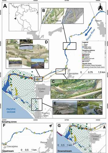
Figure 1. Site map and landscape of the Eten wetland. Doted lines in yellow indicate geomorphic settings along the river corridor, and blue lines indicate river stream and flow. F and G show sampling zones distribution
Methods
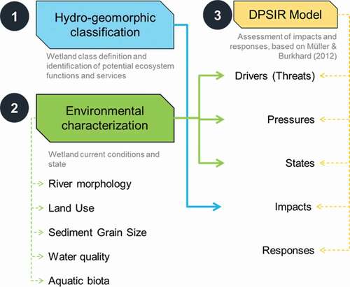
This section provides an outline of the research methods used to assess environmental impacts in Eten coastal wetland based on a hydrogeomorphic and environmental characterization (). First, a hydro-geomorphic classification was applied to categorize the Eten wetland under the Brinson (Citation1993) methodology and, according to the class, the expected ecosystem services were identified following the methodology described by Malekmohammadi and Jahanishakib (Citation2017). Second, an environmental characterization was performed using open-source tools and field measurements to determine the status of wetland components. Third, a DPSIR (Drivers, Pressures, States, Impacts, and Responses) was applied to assess possible impacts and responses in ecosystem services (Kristensen Citation2004; Malekmohammadi and Jahanishakib Citation2017; Müller and Burkhard Citation2012). The results of this assessment provide information to analyze cause–effect relationships between environmental changes and impacts on ecosystem services.
Figure 2. Components of the methodology approach to assess environmental impacts in coastal wetlands based on a hydrogeomorphic classification and environmental characterization
Hydro-geomorphic classification and identification of expected ecosystem services and human benefits
The hydro-geomorphic approach assesses the functionality of a wetland ecosystem by analyzing the physical, chemical, and biological interactions of the structural components of the ecosystem and the surrounding landscape (Engineer Research and Development Center Citation2010). According to Brinson (Citation1993), this characterization is based on: 1) the geomorphic setting or wetland geomorphology, 2) sources of water, and 3) hydrodynamics. According to these three factors, wetlands can be classified as: Depressional, Riverine, Flats (mineral and organic), Fringe (tidal/estuarine and lacustrine), and Slope. In this study, this approach is applied to the Peruvian coastal wetland Eten.
Following the methodology described by Malekmohammadi and Jahanishakib (Citation2017), the Eten wetland ecosystem functions and services were then identified based on previous research, literature review, and the guidelines described by the International Union for Conservation of Nature – IUCN (Dugan Citation1992) and the Millennium Ecosystem Assessment (MEA Citation2005) due to the lack of local data.
Characterization of environmental, biological, and biological parameters
River morphology
The characterization of the Reque river morphology was performed to describe the lateral connectivity with the Eten wetland. The planform dynamics was described using past and recent aerial photographs, GIS-based tools, such as QGIS, and open-source satellite imagery of Landsat and Google Earth Pro. Past aerial photographs of 20-cm resolution from 1949 were acquired from the Peruvian National Aerial Photography Service, and then digitalized and georeferenced. To characterize the current landscape, photogrammetry was also applied to record recent aerial imagery from August 2019. These data were processed and georeferenced to obtain a high-resolution imagery of 20-cm resolution of sections along the Reque river (, items B, C, and D), and a Digital Elevation Model (DEM). The 2019 river morphology was described and characterized along the stream using variables such as sinuosity and bar patterns. Imagery from Google Earth Pro was also used to define agricultural, urban, and dune areas. Moreover, a hillshade of azimuth 45° was obtained from the DEM to characterize geomorphic characteristics such as paleochannels or “footprints” of past dynamics.
Land Cover and Land Use analysis
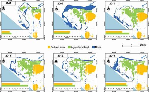
Landsat satellite imagery of 5-m resolution of 2009, 2011, 2014, 2016, and 2019 (downloaded from Google Earth Pro), and aerial photographs for the 1949s environment were processed to assess the changes in land use within the Eten wetland. To compare changes in land cover with respect to agricultural and urban development, three classes were used: water, agricultural, and built-up areas. Built-up or urban area includes all type of buildings and roads; agricultural area consists of crops and agricultural lands; and water bodies comprise oxbow lakes, ponds, and the river. Therefore, croplands were manually digitalized per month and then grouped per year. Both croplands and urban areas were considered only within the Eten estuary region.
Sediment grain size and composition
Sediment material was sampled between July 2017 and August 2019 from different sites along the Reque River and within the Eten wetland (.A) to characterize the sedimentary environment in the aquatic habitats, and to evaluate changes in sediment grain size distribution along the stream. The analysis also included the identification of the environmental conditions in which sediments were deposited. Sampling started from the Reque town down to the river mouth in which cores of 40-cm depth and surface sediment samples of 500 gr were obtained from (see ): shoreline (8 samples), cropland (15 samples), marshes (15 samples) riverbanks (19 samples), and river bedforms (5 samples).
In the laboratory, samples were mixed and quartered to uniformly distribute the sediment material. Quartered samples were weighted, and then they were dried at a temperature of 110°C ± 5°C for about 12 hours. Then, dried samples were also weighted and washed using a #230 sieve to remove sediment less than 200 μm size. Samples were one more time dried, nested, and agitated to obtain the weight of passing and retained material to finally plot the particle size distribution and material composition.
Physical-chemical parameter of water quality
In July 2017, water samples were collected once from different locations along the Reque River and within the Eten wetland to assess the influence of freshwater inputs in the wetland and the influence of agriculture and urban sprawl on water quality. Three samples were collected along the Reque river from Cascajales town to the river delta, and three samples from lakes within the Eten wetland (), following the Environmental Protection Agency (EPA) guidelines. Physical-chemical parameters included pH, Dissolved Oxygen (DO), Chemical Oxygen Demand (COD), Biochemical Oxygen Demand (BOD) conductivity, and temperature.
Aquatic biota: estuarine macroinvertebrates assemblages
In early August 2019, benthic macroinvertebrates individuals were sampled along the banks of the Reque river to evaluate the diversity of aquatic biota. There were 16 sample stations from the Reque town (upstream, yellow symbols) to the river mouth (downstream, orange symbols) as illustrated in items F and G. Based on the relative location of the flood protection structure, stations were defined to evaluate the influence of hydraulic infrastructure in aquatic biota.
At each sampling station, in an area of 1 m2, bottom substrate was removed and filtered using a kick net of a mesh diameter of 300 μm, and then filtered into sieves of an aperture of less than 425 μm to pass through the coarse sediment. Each macroinvertebrate individual collected was fixed in situ and preserved with a 3:1 concentration of water and 96% ethanol in plastic bottles of 30 ml (Samanez et al., Citation2014). In the laboratory, all specimens were identified at the family’s level, using available taxonomic keys (Domínguez and Fernández Citation2009) and reference collections (Loayza-Muro and La Matta Citation2015; Roldán Citation1996).
In addition, taxa richness S and abundance N indices were calculated to analyze the distribution and richness of macroinvertebrate communities in the wetland. Then, the Shannon-Wiener Index (H’) and the improved Shannon-Wiener Index (B) were calculated to assess families’ abundance and richness (Pielou Citation1996; Wang et al. Citation2009). In addition, equitability J’ (evenness) of families was estimated from Shannon index H to evaluate the distribution of families in a community (Il et al. Citation2010).
DPSIR (Drivers, Pressures, States, Impacts, Responses) Assessment
Developed by the European Environment Agency, the DPSIR is a conceptual model that describes the relationships between human beings and the environment under a cause-effect framework. The DPSIR model consists in a chain of causal links starting with a “driver” (a demand that influences the ecosystem, e.g., agriculture) that can cause “pressures” (when demand can modify the ecosystem, e.g., changes in land use) on the “state” of the environment (physical, chemical, and biological) thus generating “impacts” on ecosystems and human health. Finally, the understanding of the resulting impacts leads to “responses” that can be displayed in terms of decision-making, target settings, prioritization projects, and policies for risk mitigation and conservation purposes (Kristensen Citation2004). This study considered an improved DPSIR model developed by Müller and Burkhard (Citation2012), which is based on the “ecosystem service cascade” diagram, to evaluate the state of biophysical processes and ecosystem functions of the Eten wetland and how changes in the environment can impact ecosystem services and human benefits.
Results
Hydro-geomorphic classification and identification of expected ecosystem services of the Eten wetland
Based on the hydrogeomorphic classification, the Eten wetland corresponds to an Estuarine system, in which the dominant water source is the overbank flow from the Reque river, and the hydrodynamic flow structure is dominated by bidirectional and horizontal flow. The Reque river describes a delta with small streams flowing into it, forming an estuary that encloses the Eten wetland and describes a wedge-shaped section that is seasonally connected to the ocean (). Moreover, the geomorphic setting is described as a blind estuary with a characteristic funnel shape in the river mouth and foredunes formed along the coastline (Fairbridge Citation1980).
In estuarine environments, such as the Eten wetland, it is expected to have ecosystem services such as groundwater recharge, sediment retention, biological diversity, flood control, carbon sequestration, nutrient cycling, storm attenuation, sediment retention, and water regulation (Barbier Citation2019; Camacho-Valdez et al. Citation2013; Costanza et al. Citation1997; Dugan Citation1992; Perillo et al. Citation2009). These ecosystem services were then categorized as provisioning, regulating, cultural, and supporting services, following the Millennium Ecosystem Assessment (MEA Citation2005). presents the results of this classification as an input in the DPSIR model.
Table 1. Summary of ecosystem services and values of the Eten wetland. Photographs were taken during field visits and data collection
Characterization of environmental, biological, and biological parameters
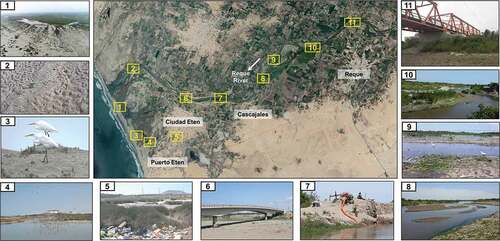
As illustrated in , two types of hydraulic structures along the river have been identified: two bridges (the Reque and Eten bridges), and the 3.5-km length dike built along the river. Additionally, intensive agricultural activities demanded channeling riverbanks to derive water inputs for croplands. The lack of waste disposal facilities also resulted in the accumulation of liquid and solid waste within the wetland.
Figure 3. Landscape condition along the Reque River. Satellite image obtained from Google Earth. From 1 to 10, photographs illustrate a variety of geomorphic settings (both in land and alluvial channel), presence of migratory birds, waste disposal, soil salinization, and river infrastructure
River morphology
The morphology of the Reque river has changed over the years (). A comparison between 1949 and 2019 indicated that the Reque river was used to create deltas generating a variety of landforms and ridges of water and sediment, and average sinuosity values indicated a moderate meandering form (1.20–1.38) (Abad, Paredes, and Montoro Citation2010; Odgaard and Abad Citation2008), especially from the Reque to Ciudad Eten town. In this section, the averaged channel width is 120 m (100 m) at the upstream (downstream) end, which indicates a channel constraint due to flooding protection structures and floodplain occupation for agricultural purposes.
Aerial photographs from August 2019 illustrate the current state of the Reque river morphology, starting from the Reque bridge until the river reaches the ocean. shows the data obtained from the photogrammetry and the sections to be analyzed:
In , a section without river embankment, the Reque river presents a wider floodplain upstream in the side in which there are less fluvial constraints (e.g., agricultural lands). Hillshades (azimuth 45°) created from the Digital Elevation Model (DEM) of aerial photographs shows a naturally meandering river morphology based on the observed paleochannel patterns (dotted yellow and red lines). Paleochannels evidenced the natural extension of the river floodplain, which was covered by croplands in different seasons. Vegetation along the stream is represented by agricultural lands, shrubs, and small trees.
In , a section located near Cascajales and a one-sided dike, aerial photographs illustrate the types of sand bars along the Reque stream. The presence of point and channel bars evidenced that the river still maintains its meandering dynamics. However, the dike on the right side constrains the sinuosity of the river, thus reducing channel migration.
In , a section with both-sides river embankment, a bridge and channelization for agriculture, the river morphology presents a different dynamic. Here, the river channel presents less curvature and more mid-channel bars created by the new equilibrium condition along the stream. In this section, there are more croplands that channelize the stream to abstract water for irrigation purposes. Moreover, the Eten bridge, the dike, and the debris accumulated below the bridge confined the stream. Consequently, the riverbank started eroding due to flow velocity increase.
Spatial analysis along the Reque river indicated that embankment for flood protection changed river morphology from a meandering to almost a braided stream, in which the channel is constrained to follow only the left margin of its natural course. Braided rivers are characterized by a wider channel prone to bank that can also increase turbidity (Ashmore Citation2013). The accumulated plant and waste debris also trap the sediment load and, consequently, increase the flow velocity. It is evidenced by the low vegetation cover in . On the one hand, river constraining can directly impact the natural flow and vegetation cover of the Reque river. On the other hand, bank erosion might also increase the maintenance cost of river infrastructure because it reduces the effectivity of dikes and flood protection.
The Reque river represents a crucial component of the Eten wetland because it represents the main source of freshwater input, and its morphology defines the wetland structure. However, lateral connectivity has been reduced due to flood protecting structures that constrain the river channel and agricultural land occupation. Channelization also disturbed the riverbanks, thus increasing bank erosion.
Land Cover and Land Use analysis
The qualitative analysis of temporal changes in land cover and land use shows a rapid increase in agricultural areas from 1949 to 2014 (). From 1949 to 2009, over a period of 60 years, agricultural activities had registered an increase of 62%. In only 2 years (from 2009 to 2011), there was an accelerated increase of 52%. However, during the 2014–2016 period, croplands were reduced in over 20%. The last 4 years that include 2016–2019 period shows a slight increase in croplands of 3%. also illustrates an extensive urban development in the last 70 years, in which urban areas doubled in size from 1949 to 2009. Then, the increased trend barely reached the 12%. The results demonstrated that extensive agricultural development, livestock farming, and the urban sprawl disturbed the natural plant and land composition of the Eten wetland.
Moreover, aerial photographs suggest soil salinization of agricultural lands. shows saline water springs in crop fields and the presence of salinity tolerant plants. In estuarine environments, river receives both saline and freshwater inputs from water, depending on the season (Phillips Citation2018).
Figure 4. Changes in land use and river morphology in the Eten wetland from 1949 to 2019. Graphs indicated maximum annual extension of water and cropland areas
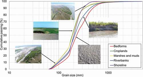
Analysis of sediment grain size and composition
summarizes the particle size distribution sampled at different locations. Bedforms (ripples) of 2–5 cm, typically characterized by fine-to-medium sand mainly carried by wind and low-velocity water flow, had a mean size grain (D50) was 247.60 μm. Sediment texture in croplands was composed of fine sand. The D50 found in crops was 189.1 μm which might be caused by tillage activity (removal and preparation of arable soils) and soil erosion due to river channelization. Moreover, finest material was found on the right side of the Reque river. Therefore, it is suggested that crop areas are an important source of finer sediment material in the Reque river, which is transported by irrigation-water flow.
The substrate in marshes was mainly medium and very fine sand and the D50 was like croplands (189.9 μm). It might be because sampling sites in marshes were located between the river and crops. Riverbanks presented greater medium coarse and fine sand content. The mean grain size D50 is about 217.8 μm and slightly tended to become finer near the river mouth in the estuary. Finally, when the Reque river reaches the sea, it creates a barrier where sediments are deposited. Sediment texture, composed of a medium-coarse to fine sand, is uniformly distributed along the estuary mouth. The average D50 value is 203.4 μm along the shoreline, not so far from the riverbank composition.
Figure 5. Average particle size distribution and mean grain size (d50) of sediments within the Eten wetland. Photographs illustrate sampling sites
Physical-chemical parameter of water quality
As indicated in , the pH values of all sites were greater than 8 during the dry season, indicating a low alkaline environment. Previous studies indicated that a decline of pH at some levels can disturb biological responses in the aquatic environment (Ringwood and Keppler, Citation2002; Wright and Worrall, Citation2001); therefore, pH values are important to monitor the biological diversity of the Eten wetland.
Table 2. Physical-chemical parameters at the sampling stations in the Eten wetland (single measurement)
The average value of dissolved oxygen (DO) was 8.975. Differences between oxbow lakes (.E) and the river values were very small and there was no evidence of hypoxia in water bodies (<2-3 mg/l O2). Conductivity decreased from the mouth to upstream and increased from the mouth to the oxbow lakes. Salinity and conductivity measures are directly related because dissolved ions increase both values, which suggests that lakes receive more brackish than freshwater inputs with increasing chloride values.
The biochemical oxygen demand (BOD) values along the Reque river were less than 2 mg/L. However, BOD increased from the mouth to the oxbow lakes. Values in farther oxbow lakes (W1 and W2) were more than 400 mg/L. Water temperatures have an average of 22°C. Warmer temperatures have been registered within the boundaries of the wetland, mainly in the oxbow lakes far from the river mouth. The chemical oxygen demand (COD) along the Reque river was less than 6 mg/L, while values in farther oxbow lakes (W1 and W2) were more than 1,000 mg/L. This can be because oxbow lakes are located near the urban areas, thus receiving more domestic wastewater inputs (), which also increased the concentration of sulfate and bicarbonate in water.
Water pollution and salinization are also evidenced by the results of the water quality evaluation. For instance, even though higher values of chloride are a consequence of brackish water inputs during coastal flooding and animals and plants are commonly adapted, concentration values could be increased by sewage and wastewater contamination, as illustrated in .
Aquatic biota: estuarine macroinvertebrates assemblages
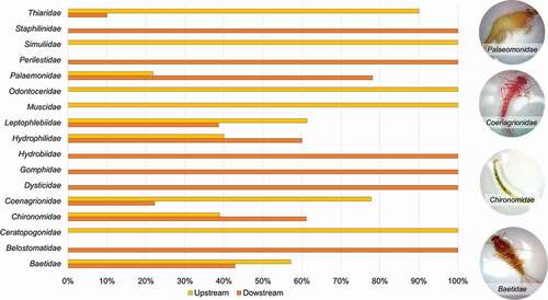
A total of 309 samples of macroinvertebrates were collected from the 16 sampling sites. They belong to 17 families distributed heterogeneously along the Reque river. Sampling sites have been characterized in two sections: from Reque to Cascajales (upstream) () and Ciudad Eten to the ocean (downstream) () Based on their relative location from the flood protection structure, this division was considered to compare the influence of hydraulic infrastructure in aquatic biota.
Results indicated that taxa richness and Shannon-Wiener index values upstream (from Reque to Ciudad Eten) were greater than downstream (from Ciudad Eten until the river reaches the ocean). It might be because the upstream zone presents a lower disturbance in the river due to channel embankment. Moreover, evenness values suggest a constant population size for families collected downstream. Nevertheless, upstream registered a disparity between the number of individuals within each family. The results indicated that the downstream area harbors fewer families than the area above the tidal limit (upstream), but the abundance of individuals was higher (mainly tolerant families). According to Zhao et al. (Citation2017), the heterogeneity in families’ distribution might be due to several causes including: 1) lower temperatures upstream, 2) type of sediment material in the substrate, and 3) few riparian vegetations along the riverbanks in the wetland region. In the Eten wetland, the loss of vegetation due to bank erosion influenced the aquatic biota.
shows the relative abundance of macroinvertebrate families. Chironomidae and Baetidae represent the most abundant families, followed by the Palaemonidae. Both Chironomidae and Baetidae families are considered detritus feeders and algae, and during their adult phase as flies they become vectors for allergies (Hall and Gerhardt Citation2002) (Hall and Gerhardt Citation2002). Chironomidae individuals are tolerant to environmental stress and their presence also suggests a high organic matter (Roldán Citation1996), elevated salinity, and heavy metal concentrations in the stream (Loayza-Muro et al. Citation2010; Mendelssohn et al. Citation2014). In case of the Palaemonidae, also known as freshwater shrimp or prawn, they play an important role in fishery and aquaculture, and are sensitive to environmental stress (Roldán Citation1996). Moreover, Ephemeroptera, Plecoptera, and Trichoptera (EPT) orders also positively affect primary production positively and are considered vital role as food for stream fishes. However, they are very sensitive to sedimentation. Upstream, individuals sampled included Odontoceridae taxa in the order Trichoptera upstream, and Baetidae taxa in the order Ephemeroptera downstream.
Results in this section indicate that the diversity of families and abundance of individuals are influenced by changes in the environment. Modifications along the river channels, such as embankment and river channelization disturb the grain-size of sediments (increase in finer sediment concentration), and physical-chemical parameters, such as temperature, DO, COD, and BOD which result in alterations in aquatic biota.
Figure 6. Relative abundance of the macroinvertebrate community sampled downstream (orange) and upstream (yellow) the Eten wetland. Photographs on the left side show some individuals found
DPSIR (Drivers, Pressures, States, Impacts, Responses) Assessment
The model uses both hydrogeomorphic classification and environmental characterization as inputs to define the drivers (threats), pressures, states, and services of the Eten wetland. Based on the hydro-geomorphic classification (section 4.1), 13 ecosystem services that the Eten wetland possibly provides were identified. The environmental characterization (section 4.2) identified 3 main threats (agricultural, livestock, and farming activities; dikes and hydraulic infrastructure for flood protection; and population growth and rapid urbanization) that influence wetland status, generating changes in river morphology, land use, sediment grain size, water quality, and aquatic biota.
As a first step in the assessment, each wetland condition was linked to one or more threats. For instance, agricultural activities modify the composition of sediment transported by increasing fine material concentration due to river channeling and uncontrolled water harvesting. Then, for each threat, we established a linkage to pressures and impacts generated based on the information collected. Following the previous example, increasing the number of finer sediments in the stream might lead to an increase in turbidity (pressure) and a reduction in aquatic habitats (impact). The last step was to correlate how the impacts affect the ecosystem services and human benefits identified. For example, the reduction in aquatic habitats can modify ecosystem services and leads, for example, to a reduction in wildlife and biological diversity, or the disturbance of nutrient cycling. shows a summary of the causal links identified among the components of the DPSIR model for the Eten wetland.
Table 3. Application of the DPSIR model to human-nature system of the Eten wetland
Threat 1: Agricultural, livestock, and farming activities
Pressures: Uncontrolled water harvesting, cultivation of fields and croplands, river channelization and water withdrawal
State: The results of the environmental characterization indicated that coastal dunes and the river floodplain have been heavily reduced due to changes in land use by agricultural activities. Consequently, this modified the sediment load and river morphology. Moreover, uncontrolled water harvesting demanded river channelization and the modification of riverbanks.
Impacts: Water exchange between the river flow and croplands also increased ion concentration; thus, it generated water pollution and fostering an abundance of tolerant biota. These pressures resulted in the alteration of water balance, soil salinization, and disturbance of the hydrological connectivity and nutrient cycling. Affected ecosystem services included provisioning, regulating, and supporting. Based on the hydrogeomorphic classification, it is expected that these impacts could affect groundwater recharge, sediment retention, waste processing, and the biological diversity of the Eten wetland.
Threat 2: Dikes and hydraulic infrastructure for flood protection
Pressures: Construction of levees and dikes, and channel embankment
State: Results of remote sensing analysis indicated that river channeling and embankment constrained the lateral dynamics of the Reque river. When the dynamics of river morphology is reduced, it causes the loss of lateral connectivity between the river and the wetland.
Impacts: Impacts on ecosystem services resulted in the alteration of water balance and the disturbance of flow regime and hydrological connectivity (possible impacts). Moreover, channel embankment can cause the capability of storm protection, thus leading to human and economic losses during flooding and extreme events. Modification of river morphology also increased the supply of very fine sediment and the velocity of river flow, thus generating bank erosion that reduced plant communities and disturbed biota and primary production population in the riverbanks. Results indicated that ecosystem values affected would be water regulation, flood control, biological diversity, and storm protection.
Threat 3: Population growth and rapid urbanization
Pressures: Waste disposal, bulldozing of marshes, land claim, and uncontrolled groundwater pumping
State: The evaluation of changes in land use and water quality indicated that the urban sprawl and rapid urbanization reduced the Eten wetland area and polluted soils and water bodies. The contamination of the Reque river and lakes within the wetland is worsening due to the lack of sewage and sanitary infrastructure in the area. Uncontrolled groundwater pumping could also foster the infiltration of pollutants into the aquifer, but more measurements should be done.
Impacts: Pressures impacted the Eten wetland by reducing wetland area, plant communities, habitats, and esthetic value. Therefore, the ecosystem services that could be affected include biological diversity; the cultural, educational, and research value; and the capability of waste processing and biomass export.
Discussion
Geomorphic and environmental features of the Eten wetland
Results of both the hydro-geomorphic and environmental characterizations indicated that the Reque river plays an important role in defining the landscape of the Eten wetland. Aerial photographs also illustrated the dynamism of the Reque river and its natural floodplain extension. The meandering nature of the Reque river determined the location of agricultural lands because it transported not only water but also nutrients that fertilize soils during flooding events.
In the last 70 years, the agricultural land area increased in 125% which fostered the demand for irrigation water. Because the river represents the main source of freshwater, channelization is a common practice for local farmers to redirect water. These modifications disturbed not only channel morphology but also habitats in overflow areas. Besides, the environmental characterization indicates that urban sprawl has caused the contamination and desiccation of water bodies and soil in areas near the urban areas.
The analysis using photogrammetry and GIS-tools indicated that embankment and river channelization constrained the lateral connectivity of the river, thus modifying floodplain morphology by increasing flow velocity and reducing sinuosity. While riverbanks from Reque to Ciudad Eten are prone to erosion, the region between the Ciudad Eten and the river mouth presents bank failures that led to the loss of riparian vegetation and aquatic communities. Therefore, bank erosion generated more sediment supply (mainly silt and clay) that increased turbidity.
Impacts of human activities on ecosystem services
The presence of hydraulic structures for flood protection in the Eten wetland caused the reduction of floodplain ecosystem functions, such as water quality and biological diversity. Losing the capacity for lateral migration reduces the formation of geomorphic structures, thus affecting flow intrusion into the floodplain and leading the soil to desiccation. Moreover, the hydrologic connectivity within the floodplain allows the streamflow to trap sediment-associated nutrients, but in crop areas trapped material also includes agriculture-derived pollutants (Hupp, Pierce, and Noe Citation2009).
Benthic macroinvertebrates play an important role in supporting the food web by cycling nutrients and contributing to the productivity of higher trophic levels (Zhao et al. Citation2017). Riverbanks provide macroinvertebrates of ecotone habitats, but they are highly sensitive to any variability of the flow, sediment concentration, and nutrients transported. Changes in water quality were evaluated based on the type of families found and how they were distributed along the Reque river. This evaluation indicated that the presence of hydraulic structures (dikes) and agricultural activities reduced the aquatic habitats and increased the diversity of tolerant families, thus disturbing the biological diversity. Moreover, urbanization in wetlands tends to generate negative impacts of aquatic biota, as indicated in Novoa et al. (Citation2020) and Vizcardo and Gil-Kodaka (Citation2015).
Results also evidenced that changes in land use disturbed the natural landscape and geomorphology, thus affecting support and regulation services, such as groundwater recharge and water regulation. Additionally, agricultural activities caused salinization of soils and desiccation of lakes due to the disconnection of the river with the floodplain. Based on municipality records, these problems are currently exacerbated by the lack of regulations, sanitation facilities, and culture of water.
Applicability for sustainable ecosystem management and conservation plans
Nowadays, most Peruvian coastal wetlands face similar issues (agricultural and urban development); however, the ecosystem response in each environment may be different. Therefore, understanding the natural processes and functions of a coastal wetland allows the valuation of ecosystem services, and its vulnerability and capability to respond. Conservation strategies and sustainable management can then be implemented based on a better understanding of the functioning of the environment and the pressures of human activities.
First, it is important to characterize the type of coastal wetland because it determines the geomorphic settings that describe the landscape. The hydro-geomorphic characterization demonstrated the role of the Reque river in determining riverine communities along the alluvial corridor and fertilizing the floodplain due to the lateral connectivity with the Eten wetland. For instance, other types of coastal wetlands are depressional (Pantanos de Villa) and lacustrine (Albufera de Medio Mundo) wetlands which might be influenced by other components, such as precipitation and groundwater; thus, the geomorphic features and ecosystem functions will be different. Once the type and features are described, potential ecosystem services of a coastal wetland can be defined. For example, depressional wetlands such as swamps and peatlands provide the service of carbon sequestration and storage. Second, an environmental characterization assesses the status of the components of a coastal wetland. By evaluating the changes in the geomorphic features (defined in the previous step); the quality of water, soil, air, plant, and animal communities; and landscape over time, it is possible to define the main threats and pressures through a cause-and-effect relationship. Third, the DSPIR framework provides a wide overview of how threats and pressures can disturb the ecosystem services and the impacts generated. Based on this information, decision-makers can respond by prioritizing conservation projects, establishing regulations to reduce the pressures, and other actions to mitigate impacts. Moreover, the framework can be applied as many times as required to evaluate the implementation of actions and responses.
The proposed methodology aims to be a tool to identify the most effective responses to reduce environmental impacts in ecosystem services, with a scope that this is a cyclic process that needs to be reinforced over time. Applied to a Peruvian coastal wetland with little field data, this study provides a rapid diagnosis of ecosystem status and potential impacts on services. Moreover, the environmental characterization applied in the methodology is not limited to the areas described above, but also nutrient analysis, soil quality, water balance, sediment transport, among other disciplines. This versatile methodology, however, can be improved by increasing the time, area of study, and field data collection. On the other hand, results are also presented in plain language for non-technical decision-makers, which helps them to easily evaluate responses and actions.
Conclusions
This study proposes a methodology to assess the impacts on ecosystem services based on the understanding of geomorphic features and status of a Peruvian coastal wetland. By combining remote sensing applications and field surveys, this study presents an approach to improve coastal wetland management through the identification of the most affected functions in terms of geomorphological changes and environmental parameters.
Considering that the study area had very limited local data, it was challenging to characterize the landscape features using only available literature data and open-source GIS tools and products. The study can be improved by acquiring high-resolution multitemporal imagery and field surveys to map the full extension of the wetland. Furthermore, the environmental characterization consisted of spatial analysis that identified the main threats and pressures in the Eten wetland. However, the accuracy of the results should be complemented with more field evidence and spatio-temporal monitoring. This study addresses the need to enhance decision-making in terms of conservation and sustainability. Based on the information derived from this methodology, it is possible to establish actions to mitigate impacts.
The results of this study indicate that agricultural and urban development generates critical pressures on the ecosystem services of the Eten wetland. Uncontrolled water abstractions and overbank modifications can lead to the loss of the wetland and its ecological value. Indeed, it is required to both prioritize conservation projects and to foster more research, monitoring, and educational activities to promote the value of the Eten wetland in the region. The methodology also aims to be versatile and provide a rapid diagnosis. Researchers can add more environmental parameters and enhance hydrogeomorphic characterization with more field data. The scope of the study can be easily adapted to inland wetlands as well.
Acknowledgments
This work was sponsored by the Sociedad Nacional de Minería, Petróleo y Energía (Contract N° 871103 signed with the Universidad de Ingeniería y Tecnología), and the Vicerrectorado de Investigación at the Pontificia Universidad Católica del Perú (Programa de Apoyo al Desarrollo de Tesis de Licenciatura - PADET 2019). We thank Dr. Raul Loayza-Muro from the Ecotoxicology Lab at the Faculty of Sciences and Philosophy, Universidad Peruana Cayetano Heredia, for providing training in benthic macroinvertebrates assessment; and the Municipality of Ciudad Eten and Mr. José Nolberto Neciosup Chafloque, for their kind support and guidance during field visits. We also acknowledge the research assistants of the water research center CITA at UTEC for their support during the field campaigns and laboratory analysis, and students from the Department of Environmental Engineering at UTEC who also participated in workshops and field visits. Thanks to anonymous reviewers, associate editor, and the editor of the journal for providing insightful comments that have improved this manuscript.
Disclosure statement
No potential conflict of interest was reported by the author(s).
Additional information
Funding
References
- Abad, J. D., J. Paredes, and H. Montoro (2010). Similarities and Differences between a Large Meandering River and an Anabranching River: The Ucayali and Amazon River Cases. Abstract EP24B‐04 Presented at 2010 Fall Meeting. American Geophysical Union. San Francisco, CA, USA.
- Angelakis, A. N., L. W. Mays, D. Koutsoyiannis, and N. Mamassis. 2012. Evolution of Water Supply Throughout the Millennia. London, UK: IWA Publishing.
- Angulo-Pratolongo, F., T. S. Schulenberg, and E. E. Puse-Fernández. 2010. “Las Aves De Los Humedales De Eten, Lambayeque, Perú.” Ecología Aplicada 9 (1–2): 71. doi:https://doi.org/10.21704/rea.v9i1-2.397.
- Aponte, H. 2017. Humedales De La Costa Central Del Perú: Un Diagnóstico De Los Humedales Santa Rosa, Laguna El Paraíso Y Albufera De Medio Mundo. CooperAcción. Lima, Peru.
- Aponte, H., D. W. Ramirez, and G. Lertora. 2018. Los Pantanos De Villa: Un Oasis De Vida En Lima Metropolitana. M. R. Effio,ed..Fondo Editorial de la Universidad Científica del Sur. Lima, Peru.
- Aponte, H., and A. Cano. 2013. “Estudio Florístico Comparativo De Seis Humedales De La Costa De Lima (Perú): Actualización Y Nuevos Retos Para Su Conservación.” Revista Lationamericana De Conservación 3 (2): 15–17.
- Aponte Ubillús, H., and D. Ramírez Huaroto. 2011. “Humedales De La Costa Central Del Perú: Estructura Y Amenazas De Sus Comunidades Vegetales.” Ecología Aplicada 10 (1): 1–9. doi:https://doi.org/10.21704/rea.v10i1-2.411.
- Ashmore, P. 2013. 9.17 Morphology and Dynamics of Braided Rivers. In J. F. B. T.-T. onG. Shroder (edited by), Treatise on Geomorphology (pp. 289–312). Academic Press. London, UK; Waltham, MA, USA. https://doi.org/10.1016/B978-0-12-374739-6.00242-6
- Autoridad Nacional del Agua. (2010). Tratamiento De Cauce Del Río Para El Control De Inundaciones En La Cuenca Chancay Lambayeque. http://repositorio.ana.gob.pe/handle/20.500.12543/520
- Autoridad Nacional del Agua. (2011). Estudio De Perfil: “Obras De Control Integral De Inundaciones En La Cuenca Media Y Baja Del Valle Chancay Lambayeque, Provincia De Chiclayo, Región Y Departamento Lambayeque.” http://repositorio.ana.gob.pe/handle/20.500.12543/2277
- Bai, X., Y. Hao, Z. Zhao, X. Liu, and K. Li. 2019. “Valuation of Ecosystem Services of Coastal Wetlands in Qinhuangdao, China.” Aquatic Ecosystem Health and Management 22 (2): 205–214. doi:https://doi.org/10.1080/14634988.2019.1635422.
- Bakun, A., and S. J. Weeks. 2008. “The Marine Ecosystem off Peru: What are the Secrets of Its Fishery Productivity and What Might Its Future Hold?” Progress in Oceanography 79 (2–4): 290–299. doi:https://doi.org/10.1016/j.pocean.2008.10.027.
- Barbier, E. B. 2013. “Valuing Ecosystem Services for Coastal Wetland Protection and Restoration: Progress and Challenges.” Resources 2 (3): 213–230. doi:https://doi.org/10.3390/resources2030213.
- Barbier, E. B. 2019. “The Value of Coastal Wetland Ecosystem Services.”In Coastal Wetlands: An Integrated Ecosystem Approach (2nd edition) edited by G. Perillo, E. Wolanski, D. Cahoon, and C. Hopkinson. Elsevier B. V. 947-964. doi:https://doi.org/10.1016/b978-0-444-63893-9.00027-7.
- Brinson, M. M. (1993). A Hydrogeomorphic Classification for Wetlands (Issue WRP-DE-4). http://citeseerx.ist.psu.edu/viewdoc/download?doi=10.1.1.463.3580&rep=rep1&type=pdf
- Burns, M. J., T. D. Fletcher, C. J. Walsh, A. R. Ladson, and B. E. Hatt. 2012. “Hydrologic Shortcomings of Conventional Urban Stormwater Management and Opportunities for Reform.” Landscape and Urban Planning 105 (3): 230–240. doi:https://doi.org/10.1016/j.landurbplan.2011.12.012.
- Butler, R. W., N. C. Davidson, and R. I. G. Morrison. 2001. “Global-scale Shorebird Distribution in Relation to Productivity of Near-shore Ocean Waters.” Waterbirds 24 (2): 224–232. doi:https://doi.org/10.2307/1522034.
- Camacho-Valdez, V., A. Ruiz-Luna, A. Ghermandi, and P. A. L. D. Nunes. 2013. “Valuation of Ecosystem Services Provided by Coastal Wetlands in Northwest Mexico.” Ocean & Coastal Management 78 (June): 1–11. doi:https://doi.org/10.1016/j.ocecoaman.2013.02.017.
- Costanza, R., R. d’Arge, R. de Groot, S. Farber, M. Grasso, B. Hannon, K. Limburg, et al.. 1997. “The Value of the World’s Ecosystem Services and Natural Capital.” Nature 387 (6630): 253–260. doi:https://doi.org/10.1038/387253a0.
- Darrah, S. E., Y. Shennan-Farpón, J. Loh, N. C. Davidson, C. M. Finlayson, R. C. Gardner, and M. J. Walpole. 2019. “Improvements to the Wetland Extent Trends (WET) Index as a Tool for Monitoring Natural and Human-made Wetlands.” Ecological Indicators 99 (December2018): 294–298. doi:https://doi.org/10.1016/j.ecolind.2018.12.032.
- Domínguez, E., and H. R. Fernández. 2009. Macroinvertebrados Bentónicos Sudamericanos: Sistemática Y Biología. 1st Editio ed. Fundación Miguel Lillo. San Miguel de Tucuman, Argentina.
- Dugan, P. J. 1992. Conservación De Humedales: Un Análisis de temas de actualidad y acciones necesarias. UICN. Gland, Switzerland.
- Elliott, A. H., R. H. Spigel, I. G. Jowett, S. U. Shankar, and R. P. Ibbitt. 2010. “Model Application to Assess Effects of Urbanisation and Distributed Flow Controls on Erosion Potential and Baseflow Hydraulic Habitat.” Urban Water Journal 7 (2): 91–107. doi:https://doi.org/10.1080/15730620903447605.
- Engineer Research and Development Center. (2010). Overview of the HGM Approach. Hydrogeomorphic Approach for Assessing Wetlands Functions. https://wetlands.el.erdc.dren.mil/overview.html
- Fairbridge, R. W. 1980. “The Estuary: Its Definition and Geodynamic Cycle.” In Chemistry and Biogeochemistry of Estuaries, edited by E. Olausson and I. Cato. Wiley. 1–35. New York, USA.
- Hall, R. D., and R. R. Gerhardt (2002). 8 - FLIES (Diptera). In G. Mullen and V. E. DURDEN (edited by), Medical and Veterinary Entomology (pp. 127–145). Academic Press. London, UK; San Diego, CA, and Burlington, MA, USA. https://doi.org/10.1016/B978-012510451-7/50010-4
- Hupp, C. R., A. R. Pierce, and G. B. Noe. 2009. “Floodplain Geomorphic Processes and Environmental Impacts of Human Alteration along Coastal Plain Rivers, USA.” Wetlands 29 (2): 413–429. doi:https://doi.org/10.1672/08-169.1.
- Il, C. W., K. S. Choi, D. P. Lyu, J. S. Lee, J. Lim, S. Lee, S. C. Shin, Y. J. Chung, and Y. S. Park. 2010. “Seasonal Changes of Functional Groups in Coleopteran Communities in Pine Forests.” Biodiversity and Conservation 19 (8): 2291–2305. doi:https://doi.org/10.1007/s10531-010-9842-9.
- INRENA, U. N. A. L. M., W. I. ProNaturaleza, and WWF. 1998. Reporte Humedales 1992-1997. Programa de Conservación y Desarrollo Sostenido de Humedales, Peru.
- Kristensen, P. (2004). The DPSIR framework. A Comprehensive/Detailed Assessment of the Vulnerability of Water Resources to Environmental Change in Africa Using River Basin Approach., 1–10. http://enviro.lclark.edu:8002/rid=1145949501662_742777852_522/DPSIROverview.pdf
- Li, Y., Y. Shi, X. Zhu, H. Cao, and T. Yu. 2014. “Coastal Wetland Loss and Environmental Change Due to Rapid Urban Expansion in Lianyungang, Jiangsu, China.” Regional Environmental Change 14 (3): 1175–1188. doi:https://doi.org/10.1007/s10113-013-0552-1.
- Loayza-Muro, R., and F. La Matta. 2015. Guía De Bioindicadores Para Evaluar La Calidad De Agua En Madre De Dios – Perú. Lima, Peru.
- Loayza-Muro, R., R. Elías-Letts, J. K. Marticorena-Ruíz, E. J. Palomino, J. F. Duivenvoorden, M. H. S. Kraak, and W. Admiraal. 2010. “Metal-induced Shifts in Benthic Macroinvertebrate Community Composition in Andean High Altitude Streams.” Environmental Toxicology and Chemistry 29 (12): 2761–2768. doi:https://doi.org/10.1002/etc.327.
- Malekmohammadi, B., and F. Jahanishakib. 2017. “Vulnerability Assessment of Wetland Landscape Ecosystem Services Using Driver-pressure-state-impact-response (DPSIR) Model.” Ecological Indicators 82 (June): 293–303. doi:https://doi.org/10.1016/j.ecolind.2017.06.060.
- Martini, I. P., R. L. Jefferies, R. I. G. Morrison, and K. F. Abraham. 2009. “Polar Coastal Wetlands: Development, Structure, and Land Use.” In Coastal Wetlands: An Integrated Ecosystem Approach, 119–156. Elsevier. New York, USA.
- MEA. (2005). Ecosystems and Human Well-being: Synthesis. In I. Press (Ed.), Assessment of Climate Change in the Southwest United States: A Report Prepared for the National Climate Assessment.
- Mendelssohn, I. A., D. P. Batzer, C. R. Holt, and S. A. Graham (2014). Abiotic Constraints for Wetland Plants and Animals. In D. P. Batzer and R. Sharitz (edited by), Ecology of Freshwater and Estuarine Wetlands (2nd ed., pp. 61–86). University of California Press. California, USA. http://www.jstor.org/stable/10.1525/j.ctt9qh2s6
- Ministerio de Comercio Exterior y Turismo. 2009. Diagnóstico De La Actividad Artesanal En La Región Lambayeque. Centro de Innovación Tecnológica Turístico-Artesanal Sipán. Lambayeque, Peru.
- Mitsch, W. J., and J. G. Gossilink. 2000. “The Value of Wetlands: Importance of Scale and Landscape Setting.” Ecological Economics 35 (1): 25–33. doi:https://doi.org/10.1016/S0921-8009(00)00165-8.
- Morris, J. T., P. V. Sundareshwar, C. T. Nietch, B. Kjerfve, and D. R. Cahoon. 2002. “Responses of Coastal Wetlands to Rising Sea Level.” Ecology 83 (10): 2869–2877. doi:https://doi.org/10.1890/0012-9658(2002)083[2869:ROCWTR]2.0.CO;2.
- Müller, F., and B. Burkhard. 2012. “The Indicator Side of Ecosystem Services.” Ecosystem Services 1 (1): 26–30. doi:https://doi.org/10.1016/j.ecoser.2012.06.001.
- Novoa, V., O. Rojas, R. Ahumada-Rudolph, K. Sáez, P. Fierro, and C. Rojas. 2020. “Coastal Wetlands: Ecosystems Affected by Urbanization?” Water (Switzerland) 12 (3): 1–19. doi:https://doi.org/10.3390/w12030698.
- Odgaard, A. J., and J. D. Abad. 2008. “River Meandering and Channel Stability.” In Sedimentation Engineering, edited by M. H. García, 439–460. American Society of Civil Engineers, Reston, Virgina, USA. doi:https://doi.org/10.1061/9780784408148.
- Perillo, G. M. E., E. Wolanski, D. R. Cahoon, and M. M. Brinson. 2009. Coastal Wetlands: An Integrated Ecosystem Approach. Elsevier Science, New York, USA.
- Phillips, J. D. 2018. “Coastal Wetlands, Sea Level, and the Dimensions of Geomorphic Resilience.” Geomorphology 305: 173–184. doi:https://doi.org/10.1016/j.geomorph.2017.03.022.
- Pielou, E. C. 1996. “The Measurement of Diversity in Different Types of Biological Collections.” Journal of Theoretical Biology 13: 131–144. doi:https://doi.org/10.1016/0022-5193(66)90013-0.
- ProNaturaleza. (2010). Humedales En La Costa Peruana. Documento Base Para La Elaboración De Una Estrategia De Conservación. (Vol. 3, Issue 2). ProNaturaleza. Fundación Peruana para la Conservación de la Naturaleza. Peru.
- Pulido Capurro, V. M., and L. Bermúdez Díaz. 2018. “Estado Actual De La Conservación De Los Hábitats De Los Pantanos De Villa, Lima, Perú.” Arnaldoa 25 (2): 679–702. doi:https://doi.org/10.22497/arnaldoa.252.25219.
- Ramirez, D. W., H. Aponte, and A. Cano. 2010. “Flora Vascular Y Vegetación Del Humedal De Santa Rosa (Chancay, Lima).” Revista Peruana De Biologia 17 (1): 105–110.
- Ringwood, A.H. and Keppler, C.J. 2002. “Water quality variation and clam growth: Is pH really a non-issue in estuaries?” Estuaries 25: 901–907. doi: https://doi.org/10.1007/BF02691338
- Rojas, C., J. Munizaga, O. Rojas, C. Martínez, and J. Pino. 2019. “Urban Development versus Wetland Loss in a Coastal Latin American City: Lessons for Sustainable Land Use Planning.” Land Use Policy 80: 47–56. December2017. doi:https://doi.org/10.1016/j.landusepol.2018.09.036.
- Roldán, G. 1996. Guía Para El Estudio De Los Macroinvertebrados Acuáticos Del Departamento De Antioquia. Pama Editores Ltda. Bogota, Colombia.
- Samanez, I., Rimarachin, V., Palma, C., Arana, J., Ortega, H., Correa, V., & Hidalgo, M. 2014. “Métodos de colecta, identificación y análisis de comunidades biológicas: plancton, perifiton, bentos (macroinvertebrados) y necton (peces) en aguas continentales del Perú” Universidad Nacional Mayor de San Marcos. Museo de Historia Natural (ed.). Ministerio del Ambiente. http://www.minam.gob.pe/diversidadbiologica/wp-content/uploads/sites/21/2014/02/Métodos-de-Colecta-identificación-y-análisis-de-comunidades-biológicas.compressed.pdf
- Spalding, M., M. Kainuma, and L. Collins. 2010. World Atlas of Mangroves. London, UK:Routledge.
- Stedman, S., and T. E. Dahl (2008). Status and Trends of Wetlands in the Coastal Watersheds of the Eastern United States 1998 to 2004. National Oceanic and Atmospheric Administration, National Marine Fisheries Service and U.S. Department of the Interior, Fish and Wildlife Service. https://www.fws.gov/wetlands/Documents/Status-and-Trends-of-Wetlands-in-the-Coastal-Watersheds-of-the-Eastern-United-States-1998-to-2004.pdf
- Tabilo, E., J. Burmeister, C. Chávez, and C. Zöckler. 2016. Humedales Y Aves Migratorias En La Costa Árida Del Pacífico Sudamericano. Etapa I: Evaluación Ecológica Rápida (Issue March). doi:https://doi.org/10.13140/RG.2.1.3004.4565. Centro Neotropical de Entrenamiento en Humedales. Mamfred-Hermsen-Stiftung. Bremen, Germany.
- Tooth, S., and T. S. McCarthy. 2007. “Wetlands in Drylands: Geomorphological and Sedimentological Characteristics, with Emphasis on Examples from Southern Africa.” Progress in Physical Geography 31 (1): 3–41. doi:https://doi.org/10.1177/0309133307073879.
- Verones, F., K. Bartl, S. Pfister, R. Jiménez Vílchez, and S. Hellweg. 2012. “Modeling the Local Biodiversity Impacts of Agricultural Water Use: Case Study of a Wetland in the Coastal Arid Area of Peru.” Environmental Science & Technology 46 (9): 4966–4974. doi:https://doi.org/10.1021/es204155g.
- Vizcardo, C., and P. Gil-Kodaka. 2015. “Estructura De Las Comunidades Macrozoobentónicas De Los Humedales De Ventanilla, Callao, Perú.” Anales Científicos 76 (1): 1–11. doi:https://doi.org/10.21704/ac.v76i1.702.
- Wagner, I., and P. Breil. 2013. “The Role of Ecohydrology in Creating More Resilient Cities.” Ecohydrology and Hydrobiology 13 (2): 113–134. doi:https://doi.org/10.1016/j.ecohyd.2013.06.002.
- Wang, Z. Y., C. S. Melching, X. H. Duan, and G. A. Yu. 2009. “Ecological and Hydraulic Studies of Step-pool Systems.” Journal of Hydraulic Engineering 135 (9): 705–717. doi:https://doi.org/10.1061/(ASCE)0733-9429(2009)135:9(705).
- Williams, R., L. Coppin, and J. Álvarez Alonso (2005). PERÚ: El Verdadero Paraíso De Las Aves. Viaje De Exploración Por La Ruta De Aves Del Norte Del Perú. https://repositorio.promperu.gob.pe/bitstream/handle/123456789/863/Peru_verdadero_paraiso_aves_2005_keyword_principal.pdf?sequence=1&isAllowed=y
- Wright, J., and Worrall, F. 2001. “The effects of river flow on water quality in estuarine impoundments.” Physics and Chemistry of the Earth, Part B: Hydrology, Oceans and Atmosphere 26 (9): 741–746. doi: https://doi.org/10.1016/S1464-1909(01)00079-X
- Wyld, L., R. A. Audisio, and G. J. Poston. 2015. “The Evolution of Cancer Surgery and Future Perspectives.” Nature Reviews. Clinical Oncology 12 (2): 115–124. doi:https://doi.org/10.1038/nrclinonc.2014.191.
- Zavalaga, C. B., J. Hardesty, G. P. Mori, C. Chávez-Villavicencio, and A. Tello. 2009. “Current Status of Peruvian Terns Sternula Lorata in Perú: Threats, Conservation and Research Priorities.” Bird Conservation International 19 (2): 175–186. doi:https://doi.org/10.1017/S0959270908008332.
- Zhao, N., M. Xu, Z. Li, Z. Wang, and H. Zhou. 2017. “Macroinvertebrate Distribution and Aquatic Ecology in the Ruoergai (Zoige) Wetland, the Yellow River Source Region.” Frontiers of Earth Science 11 (3): 554–564. doi:https://doi.org/10.1007/s11707-016-0616-x.