
 ?Mathematical formulae have been encoded as MathML and are displayed in this HTML version using MathJax in order to improve their display. Uncheck the box to turn MathJax off. This feature requires Javascript. Click on a formula to zoom.
ABSTRACT
Introduction: Quantifying fire severity is an important aspect of studying the response mechanism of terrestrial ecosystems to wildfire, and it is of great significance to fire ecology. In this paper we comprehensively introduce and compare the classification and quantification methods for fire severity; we discuss the development and application status of various methods, and we elucidate their existing problems. Results: 1) According to features of the burned area, fire severity can be classified as light, moderate, and heavy. 2) Using composite burn index (CBI) to quantify and record the fire severity. 3) In quantifying fire severity with vegetation change, there are certain limitations and theoretical problems to be solved. 4) Remote sensing could very well be an important means of measuring fire severity in the future, but there are still many problems that need to be solved before the remote sensing index can become a global fire severity indicator. Discussion and Conclusion: Only by clarifying the relationship between fire behavior, fire severity, time related variables and the pre- and post-fire ecosystem can the existing models be perfected or new, better fire severity measurement models be proposed for broad applications.
Introduction
Wildfire is one of the most important factors in terrestrial ecosystems. Fire has irreplaceable ecological significance for the evolution of terrestrial ecological community and the functioning of ecosystems (Bond and Keeley Citation2005; He and Lamont Citation2018). Fire is also a disturbance factor that must be recognized in the process of human exploitation of terrestrial ecological resources (Mori Citation2011). Wildfires can disturb the terrestrial ecosystems in various ways, and they may affect such ecological factors as soils and organisms in a complex way (Burkle, Myers, and Belote Citation2015; Cannon et al. Citation2019; Fernandez-Garcia et al. Citation2019; Walker et al. Citation2019). In order to have a more comprehensive understanding of the ecological role of wildfires in terrestrial ecosystems, researchers have proposed the term fire severity. Although this term has been proposed and used for nearly a century, the academic community still has not agreed upon the definition and quantification method (Keeley Citation2009; Malmstrom Citation2010). In 1985, a number of natural disturbance factors were described, including wildfires, hurricanes, blizzards, and freeze damage (Horn Citation1985); the authors defined fire severity as the extent to which wildfires affect organisms, communities, and ecosystems. Later, Simard defined fire severity as the degree of significant negative impact of wildfire on terrestrial systems, and pointed out that it mainly affects ecosystems (plant and animal communities) (Simard Citation1991), geographic systems (soil and water), atmosphere, wildfire management and society. In 2004, Jain proposed that fire disturbance is a continuum (Jain Citation2004) and can be divided into four parts – pre-fire environment, fire environment, post-fire environment, and ecosystem response – and that fire severity can be defined as the extent that wildfire directly affects the environment. In 2006, fire severity was defined as the degree of environmental change caused by wildfires or the level of loss in socio-economic terms (Key and Benson Citation2006). This definition has been widely used in the US forestry system. In addition, we find that apart from the term fire severity, burn severity is often mentioned in fire ecology research. According to the growing body of fire ecological literature, based on temporal and ecological context, fire severity and burn severity are used to describe the immediate fire effects and the long-term effects of fires on vegetation and soils, respectively (Key and Benson Citation2006; Lentile et al. Citation2006, Citation2007; Veraverbeke et al. Citation2010, Citation2011). In the recent “Glossary of Wildland Fire Terminology,” the term fire severity was defined as the degree to which a site is altered or disrupted by fire, and the term burn severity was defined as a qualitative assessment of the heat pulse directed toward the ground during a fire (NWCG Citation2018). However, it is often difficult to decide which term to use, and some researchers have used a new term, “fire and burn severity” (French et al. Citation2008; Morgan et al. Citation2014). It is not difficult to find that the range of objects affected by wildfires in these definitions varies; Simard pointed out that no two people interpret fire severity the same. An overview of the various definitions of fire severity shows that the current definition of fire severity refers to the broad range of impacts caused by wildfires, chiefly “the degree to which an ecosystem is altered by wildfire.”
The reason for proposing the term fire severity is to describe how the fire behavior affects ecosystems, but current science and technology cannot extract information such as the actual fire intensity or residence time from burned area. Also, fire behavior can cause widely different results in different ecosystems. Even though most literature shows that fire severity is the product of fire intensity and residence time, the same fire intensity and residence time can produce very different fire severity in different ecosystems; i.e., fire behavior cannot completely determine the severity of a fire. The severity of fire based on the survey of the burned area is an indispensable part of the study of the relationship between wildfire and terrestrial ecosystems. To better understand the impact of different fire behaviors on various ecological processes of terrestrial ecosystems, and to better develop, utilize, and manage human social ecological resources, it is essential to characterize and quantify the severity of fire. It is indeed disappointing that there is no widely accepted quantitative measurement standard of fire severity that can be widely used in terrestrial ecosystems. Despite the complexity of ecosystems, some researchers even believe that a single system may not be enough to quantify the severity of fire (DeBano et al. Citation1998). For nearly half a century, wildfire researchers have proposed a variety of qualitative and quantitative measurement methods of fire severity from the perspectives of field survey and remote sensing monitoring of burned areas, and have committed to providing qualitative and quantitative results for different ecosystems. However, many problems still exist in the methods of qualitative and quantitative of measuring fire severity. These have hampered our understanding of the role of wildfire in various terrestrial ecosystems. Improvements of existing methods and introduction of new methods for measuring fire severity are sorely needed.
Based on the above research background, we comprehensively introduce the existing four types of fire severity classification and/or quantification methods; we describe the basic inherent attributes of each method, and analyze the problems and deficiencies of these methods. In addition, we sorted out the relationships between the local ecosystem, fire behavior, temporal recovery, fire severity, and ecosystem response, and we point out that quantification of fire severity should focus on the difference between the pre-fire ecosystem and post-fire ecosystem and temporal recovery. In addition, we also introduce quantitative ideas of other indicators in order to provide a reference for proposing and developing a new quantification models of fire severity.
Fire severity classification and quantification method
Description of fire severity classes
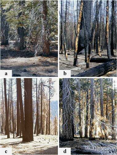
The term fire severity, as it was first proposed, was not associated with any practical quantitative methods, but by classification some indicators that are difficult to quantify can be introduced into data analysis. For this reason, fire severity in ecology mostly involves classification. However, the classification methods for fire severity have never been unified. Large differences exist between different terrestrial ecosystems, and it is difficult to propose a unified classification standard. In addition, the classification of fire severity is largely based on human sensory evaluation, and it is relatively easy to classify severity of fire in the investigation of burned areas (), so the standardization of classification has not received widespread attention.
Figure 1. Examples of 2001 Hoover fire severity classes (van Wagtendonk, Root, and Key Citation2004), a, unburned; b, high; c, moderate; d, light
Combustible materials are the material basis of fire. Living organisms can produce fuel under suitable environmental conditions, and the environment can also be affected by various aspects of fuel, including the fuel loading, combustion characteristics, combustion mode and degree of combustion. Through surveying the literature on the depth of biomass burning and carbonation, Ryan and Noste divided fire severity into four levels: unburned, light, moderate, and deep, and they described the severity classification features for three ecosystems of forest, shrub, and grassland (Ryan and Noste Citation1985). Later, the coniferous forest fire severity was divided into four categories: unburned, light surface fire, deep surface fire, and canopy fire, and the corresponding forest land features were described (Turner et al. Citation1994). In 2002, Ryan compiled the classification methods of many previous studies and divided the fire severity into five levels: unburned, scorched, light, moderate, and deep (Ryan Citation2002). The characterization of each level is streamlined and revised for clarity. These authors have made significant contributions to the classification of fire severity. Some researchers use a single indicator to determine the fire severity according to the requirements of the research subject; for example, based on the fire damage to the canopy, fire severity is divided into six classes and assigned values (). The scheme can still be used to study the effect of fire disturbance on the tree species composition (Johnstone et al. Citation2010). However, other researchers pointed out that measurement of fire severity must simultaneously consider the below-ground level, the understory level, and the canopy level in order to examine the overall fire severity at a site (Knox and Clarke Citation2016). Even though existing fire ecological research has not yet unified the fire severity classification standard, the fire severity classification method compiled by Ryan has found widespread use. Based on Ryan’s classification method and field investigation operability, we tabulated the fire severity classification and feature description to serve as an observation reference ().
Table 1. Canopy-severity index and their characteristics descriptions
Table 2. General forest fire severity classes and their characteristics descriptions, summarized and modified from (Keeley Citation2009; Ryan Citation2002; Ryan and Noste Citation1985; Turner et al. Citation1994)
Classification of the fire severity solves many problems that must be addressed in fire ecology and can partially explain the impact of fire severity on processes in terrestrial ecosystems. However, because such classification does not quantify the fire severity, it is still not possible to compare the fire severity within the same ecosystem and within the same fire severity class. This has prevented us from better explaining the relationship between wildfire and ecosystem response and has limited our understanding of the role of wildfire in ecology.
Quantifying fire severity with a composite burn index (CBI)
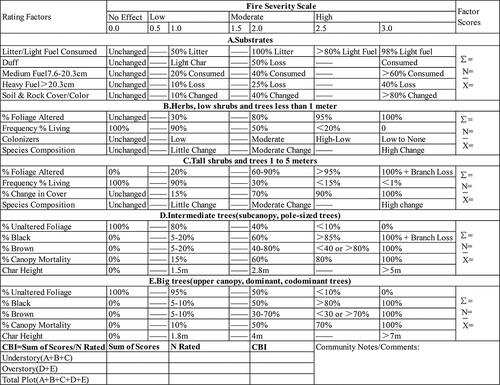
Based on the survey of burned areas, CBI was proposed and repeatedly improved (Key and Benson Citation1999, Citation2006). The index can quantify fire severity and compare the fire severity of multiple fires within the same ecosystem, which helps to further understanding of the relationships between wildfires and ecosystem responses. The CBI has now become the standard of the US Forest Service for field investigation and evaluation of fire severity. Based on a CBI survey of burned area, the ecosystem is divided into two main layers, an upper layer and a lower layer, according to the spatial vertical structure. The two main layers are then divided into five small layers according to the specified height and attributes, with each small layer having 4–6 survey items for a total of 23 survey items. Each item is based on observations or estimates and is assigned a value in the set 0, 0.5, 1, 1.5, 2, 2.5, and 3. The CBI index is the mean of all survey items, and the survey items are the most detailed among all five severity survey methods. In this paper, we have compiled a simplified CBI questionnaire as a reference for field surveys (). Since its introduction, the CBI has been popular among ecologists and is one of the most commonly used methods for measuring fire severity in ecology research. One study compared CBI with canopy fire severity indices by examining the relationships between fire disturbance and the composition of tree species in a burned area; the results showed that CBI can better explain the effects of fire severity on species composition (Johnstone et al. Citation2010). Many fire ecology studies have used CBI to quantify fire severity and to explain the effects of fire severity on biomass, density, and seedling turnover of several dominant species (Black et al. Citation2018). However, CBI does not standardize the metrics of terrestrial ecosystems, and it was also pointed out in the definition of CBI that the index is more suited for estimating the fire severity of forests than for shrubs or grasslands (Key and Benson Citation2006). In addition, it is also possible that the CBI underestimated the intensity of ground fire. Thus, CBI has several limitations that have led researchers to propose and adopt a modified version to quantify fire severity. Based on CBI, the Korean Composite Burn Index (KCBI) was developed, and it appears more suitable for Korean forests (Won Citation2012). The GeoCBI, an improved version of CBI, based on the relationships between surface reflectance and CBI of burned areas, was proposed to strengthen the correlation between ground surveys and remote sensing monitoring (De Santis and Chuvieco Citation2009). In a recent study, a partially revised CBI questionnaire with fewer survey items was used to investigate the fire severity of coniferous forests in fire-prone areas (Fernández-García et al. Citation2018).
Figure 2. Simplified composite burn index (CBI) field data form
On the whole, use of CBI has made significant progress over the abovementioned fire severity classification. As an evaluation method, it can differentiate the fire severity between burned areas of the same fire severity class and in the same ecosystem, and the obtained CBI value can better serve the post-processing analysis of the mechanisms of an ecosystem’s response to fire disturbance. The CBI represents an enormous improvement in the quantification of fire severity based on surveys of burned areas. It has become the preferred reference method in fire ecology for quantitative evaluation of fire severity and for measuring the correlation between environmental observational data and fire severity.
Quantifying fire severity by vegetation change
Combustion is a process during which the form of matter changes rapidly, with a release of energy that can cause significant changes in the biological and ecological environment. As long as the change is easily quantified and is significantly correlated with the severity of the fire, it may be used to represent or quantify the fire severity. Such change can be a change in the quantity and quality of organisms, or a change in the biological coverage or diversity, either as biological change or as environment change. Different from the above three fire severity classification or quantification methods, the fire severity here is quantified based on the vegetation change. The quantification is generally based on a single ground survey factor; the survey items are clear and defined; the data source is objective; the quantification method is simple, and the operability is strong. For example, fire severity may be quantified directly by factors such as the changes in tree density, biomass, basal area, or shrub height (Chappell and Agee Citation1996; Larson and Franklin Citation2005; Wang and Glenn Citation2009; Moya et al. Citation2019). These changes are based on the death of organisms due to fire, but it is usually not easy to determine whether an organism died directly from the fire or even died at all. The sensitivity of different species to wildfires may be very different, and secondary hazards may occur after a fire, thus it is often difficult to determine if the death of certain organism is caused by wildfire or the result of ecosystem response. The cause of tree death can be complex, and many factors can lead to misjudgment; for example, bark beetles that are not easy to detect spread quickly after forest fire (Ray et al. Citation2019; Stevens-Rumann, Morgan, and Hoffman Citation2015), changes in soil physical and chemical properties after wildfires (Holden et al. Citation2016; Ludwig et al. Citation2018; Quintero-Gradilla et al. Citation2015), and changes of microclimate after forest fires (Refsland and Fraterrigo Citation2018; Watts and Kobziar Citation2015). Additionally, different plants respond differently to wildfires (Bright et al. Citation2019). After a wildfire on the grassland, the roots of most plants are still alive and can re-sprout in a short while. Many hardwood trees (such as Quercus, Alnus, and Betula) and shrublands can also be re-sprout quickly from the surviving branches or roots after fire, but coniferous trees and some broad-leaved trees above ground cannot re-sprout after death. In addition, there are also many theoretical challenges in quantifying fire severity using rates of change. Fire severity indicated by a 0% or 100% mortality rate of the dominant species does not agree with the actual fire severity (especially for planted forests). This is because any fire behavior has a fire severity, but it does not necessarily cause death or changes in the dominant species. Even if the rate of change of the dominant species is 100% (all dead), it cannot be said that it has reached the maximum fire severity. Although under certain conditions the rate of change can serve well in quantifying fire severity, changes in ecosystems are affected by a variety of factors (e.g., tree species and tree age have a significant impact on the tree deaths caused by fire). Moreover, the vegetation change is generally based on a single indicator, but the sensitivity of different organisms to wildfires or the response mechanisms of environmental factors to wildfires vary greatly. All these points indicate that there are numerous limitations in using the rate of change of the ecosystems caused by fire to quantify the severity of fires.
Quantifying fire severity by remote sensing index
The combination of remote sensing and geographic information systems and models can monitor and simulate the temporal and spatial changes of surface vegetation. This capability is well suited for monitoring the recovery of burned areas, and it is also an ideal means for measuring fire severity. The method of quantifying fire severity through remote sensing is mainly based on Landsat data. Among all remote sensing data, Landsat data plays an important role in spatial and temporal scaling, and has several advantages. For example, medium resolution (30 m pixels) and long-term continuous multi-band data recording (nearly 50 years) have been widely used in ecosystem monitoring (Cohen and Goward Citation2004; Zhu, Woodcock, and Olofsson Citation2012). The data extracted from remote sensing images can be used, with reliable model calculations, as a good map for quantifying fire damage and constructing more accurate distribution map of fire severity. In this paper, we list the major current remote sensing data that can be used to construct a fire severity index (see ). Besides, in recent years, high-spatial-resolution imagery and point cloud data collected pre and/or post fires by unmanned aerial vehicles (UAVs) or Lidar have also been used as attempts to measure fire severity (Arkin et al. Citation2019; Filippelli, Lefsky, and Rocca Citation2019; Hoe, Dunn, and Temesgen Citation2018; Luis Montealegre et al. Citation2014; McKenna et al. Citation2017; Wallace et al. Citation2016).
Table 3. Common remote sensing indices for quantifying fire severity
On the whole, there are many remote sensing indices in the literature for quantifying fire severity, making it difficult to extract a unified index. The computational models tend to be complex, and the analytical methods diverse. A universally applicable remote sensing index for quantifying fire severity has not been developed. Among the indices, NBR and its derived quantitative models (dNBR, RdNBR) are the most common, and together with many other quantitative models, they have created a situation of “one hundred flowers in bloom, with one dominating.” Different remote sensing indices have different applications, while NBR itself has many limitations. The NBR reflects the remote sensing spectral index at a certain moment, and although its value is positively correlated with fire severity, it cannot identify the burned area or eliminate the effects of vegetation heterogeneity. Derived on this basis, dNBR can reflect the difference before and after the fire. However, dNBR should also be improved because: (1) Forest landscapes are heterogeneous, so dNBR is not suitable for large-scale severity measurement; (2) There is no consensus on the classification of fire severity under dNBR, and subjective judgment still exist; (3) dNBR is not suitable for ecosystem response prediction; and (4) dNBR is not suitable for quantifying fire severity immediately after a fire (Roy, Boschetti, and Trigg Citation2006). To apply remote sensing data, we need to establish an effective mathematical model with ground-measured data. Since different researchers focus on different objects, the ground-measured fire severity data are often different (Safford et al. Citation2008), resulting in different optimal fire severity remote sensing index models. The correlation between dNBR and CBI in non-forest fires is very low (Epting, Verbyla, and Sorbel Citation2005), but RdNBR is more closely related to fire severity when surface biomass is lower (Miller and Thode Citation2007; Stambaugh, Hammer, and Godfrey Citation2015). This may be related to the different ranges of application of remote sensing index, and CBI is more suitable for forests. There is an urgent need for a better method of measuring fire severity, so that a good mathematical model can be established between the remote sensing index and the fire severity.
Challenges common to all assessments of fire severity and recommendations for improvement
The classification and quantification of fire severity have mainly involved the four categories described above. Each method has its own advantages and disadvantages. There is not yet a consensus on the specific measurement method of fire severity, and there is no unified international standard for the classification or quantification of fire severity. Although there is a certain correlation between these methods, and some mathematical models of their mutual relations have been constructed (Halofsky and Hibbs Citation2009), there are still many problems in the measurement of severity. (1) Data source issues. The fire severity classification and CBI are overly influenced by subjectivity. The results obtained by different researchers may be large vary greatly. The remote sensing data source is objective, but it is not easy to obtain and process remote sensing data that meet the requirements. The rate of change data is simple and objective, but these data are difficult to obtain under certain circumstances (such as determining whether an organism died directly in fire, and the data on grasses, shrubs, and tundra). (2) Ecosystem applicability issues. Some methods are not applicable to certain ecosystems, such as CBI for grassland and shrubs, dNBR for low biomass areas, or the rate of change of plantations. (3) Quantitative methods and the applicability to fire behavior. Some methods are not applicable to certain fire behaviors. Methods such as CBI, and CSI or other remote sensing indices are not applicable to quantification of ground fire severity; rates of change, such as mortality, are not suitable for quantification of mild, rapid-moving surface fires in forests. (4) The applicability of results. Fire severity classification cannot meet the requirements for further identification of fire disturbance. Certain methods of fire measurement are not suitable for studying the responses of various ecological factors to fire disturbance (Safford et al. Citation2008). The vegetation change and remote sensing indices are not suitable for comparing quantitative results in different ecosystems (such as CSI’s quantification of grassland and forest fire severity). (5) The timing problem of the survey. Although all quantification methods are closely related to time, none of the four methods has given a clear description of the time since fire occurs, and the phenological period of data during pre-fire vegetation and during fire severity investigation. Also, the post-fire ecosystem is constantly changing over time (Santos et al. Citation2019; Strand et al. Citation2019). (6) Consideration of the role of fire ecology. Wildfires have dual characters: they can not only destroy surface vegetation but also promote the growth of surface vegetation (Arturo Rodriguez-Trejo, Pausas, and Gelacio Miranda-Moreno Citation2019). The rate of change of certain indicators (such as biomass and basal area) and some remote sensing indices (such as NDVI, dNBR) may contradict the theoretical fire severity, because the vegetation biomass and other indicators measured after the fire may be greater than or equal to that before the fire investigation. These problems must be considered and solved in optimizing the measurement method for fire severity. It is necessary to re-visit the nature of fire severity and the relationships between fire severity and other related factors.
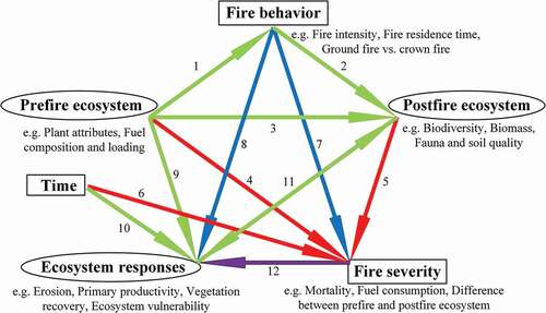
Fire severity is a latent variable that can be quantified by the changes in manifest variables of ecosystems caused by fire. It can be investigated after the fire, or it can be predicted before the fire (Cram, Baker, and Boren Citation2003; Fang et al. Citation2018; Keyser and Westerling Citation2019; Mitsopoulos et al. Citation2019; Sikkink and Keane Citation2012). Severity results from a combination of pre-fire ecosystems, fire intensity, and duration, whereas the current state of the ecosystem is the product of the pre-fire ecosystem, fire severity, temporal recovery, and ecosystem response. Vegetation, fire behavior, fire duration, fire severity, and ecosystem response are closely related, so it is unreasonable to ignore the relationship between them in classification and quantifying fire severity, and may affect the accurate prediction of ecosystem response (Doerr et al. Citation2006; Keeley, Brennan, and Pfaff Citation2008). Further optimization of the fire severity quantification method should take into account such interrelationships (). The state of the pre-fire ecosystem plays a decisive role in fire behavior (green line labeled 1), because fuel come from living organisms, and the load, distribution, composition, and characteristics of fuel depend on the characteristics of the organisms, such as in the differences in fire behavior of forest and grassland. The pre-fire ecosystem and fire behavior together determine the post-fire ecosystem (green lines labeled 2 and 3). Because fire behavior can determine some of the environmental factors and the life and death of organisms, there is a close relationship between pre-fire and post-fire vegetation. This is also the main reason why wildfire can promote ecosystem succession and renewal. The difference between pre-fire and post-fire ecosystems is the cornerstone of all severity-measurement methods (red lines labeled 4 and 5), but we argue that it is not enough to consider only the differences between the two, as this difference is constantly changing with temporal recovery (red line labeled 6). Although fire behavior is closely related to fire severity, it is usually not used to quantify the severity of fire (blue line labeled 7), because it is difficult to obtain information on fire behavior and does not conform to the nature of fire severity measurement (Johnstone et al. Citation2011). There is the possibility that different ecosystems with the same fire behavior may have different fire severity and different ecosystem response (blue lines labeled 7 and 8). Although the pre-fire ecosystem determines the ecosystem response to a certain extent, the relationship between the two is restricted by fire behavior (green line labeled 9). Sometimes, the pre-fire ecosystem can determine the ecosystem response (such as in short-term changes in primary productivity at low fire severity), but sometimes it cannot (such as in changes in soil erosion at very high fire severity). In addition, it is difficult to determine whether the ecosystem can be restored to the pre-fire level after the wildfire occurs (Grau-Andres et al. Citation2019), and there is the possibility of permanent changes in vegetation. The ecosystem response is a long-term process (green line labeled 10) that is directly affected by post-fire ecosystems (green line labeled 11), fire severity (purple line labeled 12), and fire behavior (blue line labeled 8) (Bontrager et al. Citation2019; Lewis, Wu, and Robichaud Citation2006; Ruiz-Gallardo, Castano, and Calera Citation2004). The post-fire ecosystem is both the basis for and the result of ecosystem response (green line labeled 11). The information about fire behavior is difficult to obtain, and the interpretation of some of the responses of the ecosystem is limited (such as with soil erosion, soil temperature change, and primary productivity change) (blue lines). Therefore, the quantification of fire severity is essential to understand the ecosystem response to fire disturbance (purple line). Hence, the quantification method for fire severity based on ecological changes of the burned area and the temporal recovery must and will naturally become the fundamental criterion (red lines). The quantification result of fire severity is directly proportional to the absolute value of the difference between the pre- and post-fire ecosystems. If this difference (such as in biodiversity or surface combustible load) gradually decreases with increasing temporal recovery, then the fire severity is inversely proportional to the temporal recovery. If this difference (such as in forest type or vegetation type change) gradually increases, then fire severity is inversely proportional to temporal recovery; that is, the mathematical relationship between fire severity and temporal recovery depends on the attributes of the selected difference and the ecosystem response.
Figure 3. Conceptual model for fire severity measuring. Ellipse indicates latent variable; rectangle indicates manifest variable. Besides, green lines indicate respective relationships that are significant but restricted/ non-unique; purple lines indicate relationships that we expect to recognize; red lines indicate relationships that must be utilized, which are the cornerstones of all fire severity measurement methods; blue lines indicate relationships that are difficult to be observed or exploited
With the development of science and technology, humans will have more sophisticated ways to monitor the ecosystem, and there will be improved methods to quantify fire severity (Parks et al. Citation2018). In our view, remote sensing is likely to be an important means of measuring fire severity in the future. However, to develop new fire severity classification and quantification models, it is necessary to fully understand the problems existing in these methods and fully consider the relationships between the fire severity, ecosystem, time related variables, and fire behavior. For example, different remote sensing indices respond differently to different vegetation types, and a mathematical model is needed to effectively relate remote sensing indices to fire severity. New quantitative methods must be universal; data sources must be objective, and standards must be developed for reference by others. In the quantification of fire severity, the quantification methods of humidity and temperature can be referred to. Humidity is often used to better describe how dry or wet the atmosphere is, but it is impossible for us to quantify the humidity through human perception, because affected by other environmental conditions, such as temperature, the same person may feel the same humidity differently, and different levels of humidity may feel the same. However, once the absolute humidity, relative humidity, specific humidity, and their corresponding quantification standards are determined, and the respective hygrometers are produced, the reaction to humidity can be separated from human perception, because there will be a common, universal, and objective reference standard for the degree of air dryness and wetness. “Cold” and “hot” are often used to describe the temperature of objects. Although cold and hot can explain aspects of the natural phenomena, they cannot meet the needs of further understanding. In order to compare the temperature of objects on a deeper level, descriptive terms for temperature classification (for example, high temperature, normal temperature, low temperature, and ultra-low temperature) were proposed. Subsequently, a standard for quantifying temperature, the temperature scale, was developed and established. For example, on the Celsius scale, the temperature of ice-water mixtures and that of boiling water at standard atmospheric pressure were set to 0°C and 100°C, respectively. On the Fahrenheit scale, the temperature of an ice-water mixture at standard atmospheric pressure and the body temperature [sic] were set to 32°F and 100°F, respectively. The development of temperature scale enables the quantification of temperature, and a thermometer can be produced using the thermal expansion and contraction characteristics of mercury, alcohol, and other materials, so that we have a common reference for the description of hot and cold. Temperature and humidity scales met the needs for humans to quantify temperature and humidity, improved human cognition of the relationship between natural phenomena and temperature and humidity, and contributed greatly to the development of human society. The introduction and quantification of fire severity may also experience a process similar to that of humidity and temperature. Since our description of fire severity is still at the stage of subjective classification and estimating, even though the quantification of fire severity using remote sensing is objective, it is still similar to measuring temperature or humidity with a thermometer or hygrometer without a scale.
The differences between these quantitative results may affect, or may have affected human understanding of fire, which is an important ecological factor. There is an urgent need to produce a more scientific, rational, and universally applicable standard method of measuring fire severity. Even though this process may not be easy, it is worth to exploring and effort by fire ecologists.
Acknowledgments
The present manuscript has greatly benefited from discussion with Sisheng Luo, Zhaoguo Li, and Yunjia Ma and their comments on an earlier draft. Thanks to everyone for providing references. This research was made possible through funding of the Natural Science Foundation of Heilongjiang Province of China [LH2021C011], the National Natural Science Foundation of China [31870644] and the National Key R&D Program of China During the 13th Five-Year Period [2017YFD0600106-2].
Disclosure statement
No potential conflict of interest was reported by the author(s).
Additional information
Funding
References
- Chappell, C.B., and J.K. Agee, C. B. C. A. 1996. “Fire Severity and Tree Seedling Establishment in Abies Magnifica Forests, Southern Cascades, Oregon.” Ecological Applications, 6 (2): 628–12. doi:https://doi.org/10.2307/2269397
- Arkin, J., N. C. Coops, T. Hermosilla, L. D. Daniels, and A. Plowright. 2019. “Integrated Fire Severity-land Cover Mapping Using Very-high-spatial-resolution Aerial Imagery and Point Clouds.” International Journal of Wildland Fire 28 (11): 840–860. doi:https://doi.org/10.1071/WF19008.
- Arturo Rodriguez-Trejo, D., J. G. Pausas, and A. Gelacio Miranda-Moreno. 2019. “Plant Responses to Fire in a Mexican Arid Shrubland.” Fire Ecology 15 (UNSP 11). doi:https://doi.org/10.1186/s42408-019-0029-9.
- Black, D. E., Z. W. Poynter, C. A. Cotton, S. Upadhaya, D. D. Taylor, W. Leuenberger, B. A. Blankenship, and M. A. Arthur. 2018. “Post-wildfire Recovery of an Upland Oak-pine Forest on the Cumberland Plateau, Kentucky, USA.” Fire Ecology 14 (UNSP 14). doi:https://doi.org/10.1186/s42408-018-0013-9.
- Bond, W. J., and J. E. Keeley. 2005. “Fire as a Global ‘Herbivore’: The Ecology and Evolution of Flammable Ecosystems.” Trends in Ecology & Evolution 20 (7): 387–394. doi:https://doi.org/10.1016/j.tree.2005.04.025.
- Bontrager, J. D., P. Morgan, A. T. Hudak, and P. R. Robichaud. 2019. “Long-term Vegetation Response following Post-fire Straw Mulching.” Fire Ecology 15 (UNSP 22). doi:https://doi.org/10.1186/s42408-019-0037-9.
- Bright, B. C., A. T. Hudak, R. E. Kennedy, J. D. Braaten, and A. H. Khalyani. 2019. “Examining Post-fire Vegetation Recovery with Landsat Time Series Analysis in Three Western North American Forest Types.” Fire Ecology 15 (UNSP 8). doi:https://doi.org/10.1186/s42408-018-0021-9.
- Burkle, L. A., J. A. Myers, and R. T. Belote. 2015. “Wildfire Disturbance and Productivity as Drivers of Plant Species Diversity across Spatial Scales.” Ecosphere 6 (10): art202. doi:https://doi.org/10.1890/ES15-00438.1.
- Cannon, J. B., S. K. Henderson, M. H. Bailey, and C. J. Peterson. 2019. “Interactions between Wind and Fire Disturbance in Forests: Competing Amplifying and Buffering Effects.” Forest Ecology and Management 436: 117–128. doi:https://doi.org/10.1016/j.foreco.2019.01.015.
- Chuvieco, E., M. P. Martín, and A. Palacios. 2002. “Assessment of Different Spectral Indices in the Red-near-infrared Spectral Domain for Burned Land Discrimination.” International Journal of Remote Sensing 23 (23): 5103–5110. doi:https://doi.org/10.1080/01431160210153129.
- Cohen, W. B., and S. N. Goward. 2004. “Landsat’s Role in Ecological Applications of Remote Sensing.” Bioscience 54 (6): 535–545. doi:https://doi.org/10.1641/0006-3568(2004)054[0535:LRIEAO]2.0.CO;2.
- Cram, D. S., T. T. Baker, and Boren. 2003. “Inventory and Classification of Wildland Fire Effects in Silviculturally Treated Vs. Untreated Forest Stands of New Mexico and Arizona.” Chemical Physics 400 (400): 59–64.
- De Santis, A., and E. Chuvieco. 2009. “GeoCBI: A Modified Version of the Composite Burn Index for the Initial Assessment of the Short-term Burn Severity from Remotely Sensed Data.” Remote Sensing of Environment 113 (3): 554–562. doi:https://doi.org/10.1016/j.rse.2008.10.011.
- DeBano, L. F., D. G. Neary, Ffolliott, and P. F. 1998. “Fire’s Effects on Ecosystems.” J. Wiley.
- Doerr, S. H., R. A. Shakesby, W. H. Blake, C. J. Chafer, G. S. Humphreys, and P. J. Wallbrink. 2006. “Effects of Differing Wildfire Severities on Soil Wettability and Implications for Hydrological Response.” Journal of Hydrology 319 (1–4): 295–311. doi:https://doi.org/10.1016/j.jhydrol.2005.06.038.
- Epting, J., D. Verbyla, and B. Sorbel. 2005. “Evaluation of Remotely Sensed Indices for Assessing Burn Severity in Interior Alaska Using Landsat TM and ETM+.” Remote Sensing of Environment 96 (3–4): 328–339. doi:https://doi.org/10.1016/j.rse.2005.03.002.
- Fang, L., J. Yang, M. White, and Z. Liu. 2018. “Predicting Potential Fire Severity Using Vegetation, Topography and Surface Moisture Availability in a Eurasian Boreal Forest Landscape.” Forests 9 (3): 130. doi:https://doi.org/10.3390/f9030130.
- Fernandez-Garcia, V., E. Marcos, J. Manuel Fernandez-Guisuraga, A. Taboada, S. Suarez-Seoane, and L. Calvo. 2019. “Impact of Burn Severity on Soil Properties in a Pinus Pinaster Ecosystem Immediately after Fire.” International Journal of Wildland Fire 28 (5SI): 354–364. doi:https://doi.org/10.1071/WF18103.
- Fernández-García, V., M. Santamarta, A. Fernández-Manso, C. Quintano, E. Marcos, and L. Calvo. 2018. “Burn Severity Metrics in Fire-prone Pine Ecosystems along a Climatic Gradient Using Landsat Imagery.” Remote Sensing of Environment 206: 205–217. doi:https://doi.org/10.1016/j.rse.2017.12.029.
- Filippelli, S. K., M. A. Lefsky, and M. E. Rocca. 2019. “Comparison and Integration of Lidar and Photogrammetric Point Clouds for Mapping Pre-fire Forest Structure.” Remote Sensing of Environment 224: 154–166. doi:https://doi.org/10.1016/j.rse.2019.01.029.
- French, N. H. F., E. S. Kasischke, R. J. Hall, K. A. Murphy, D. L. Verbyla, E. E. Hoy, and J. L. Allen. 2008. “Using Landsat Data to Assess Fire and Burn Severity in the North American Boreal Forest Region: An Overview and Summary of Results.” International Journal of Wildland Fire 17 (4): 443–462. doi:https://doi.org/10.1071/WF08007.
- Gao, B. C. 1996. “NDWI—A Normalized Difference Water Index for Remote Sensing of Vegetation Liquid Water from Space.” Remote Sensing of Environment 58 (3): 257–266. doi:https://doi.org/10.1016/S0034-4257(96)00067-3.
- Gerard, F., S. Plummer, R. Wadsworth, A. F. Sanfeliu, L. Iliffe, H. Balzter, and B. Wyatt. 2003. “Forest Fire Scar Detection in the Boreal Forest with Multitemporal SPOT-VEGETATION Data.” Ieee Transactions on Geoscience and Remote Sensing 41 (11): 2575–2585. doi:https://doi.org/10.1109/TGRS.2003.819190.
- Grau-Andres, R., G. M. Davies, S. Waldron, E. M. Scott, and A. Gray. 2019. “Increased Fire Severity Alters Initial Vegetation Regeneration across Calluna-dominated Ecosystems.” Journal of Environmental Management 231: 1004–1011. doi:https://doi.org/10.1016/j.jenvman.2018.10.113.
- Halofsky, J. E., and D. E. Hibbs. 2009. “Relationships among Indices of Fire Severity in Riparian Zones.” International Journal of Wildland Fire 18 (5): 584–593. doi:https://doi.org/10.1071/WF07050.
- He, T., and B. B. Lamont. 2018. “Baptism by Fire: The Pivotal Role of Ancient Conflagrations in Evolution of the Earth’s Flora.” National Science Review 5 (2): 237–254. doi:https://doi.org/10.1093/nsr/nwx041.
- Hoe, M. S., C. J. Dunn, and H. Temesgen. 2018. “Multitemporal LiDAR Improves Estimates of Fire Severity in Forested Landscapes.” International Journal of Wildland Fire 27 (9): 581–594. doi:https://doi.org/10.1071/WF17141.
- Holden, S. R., B. M. Rogers, K. K. Treseder, and J. T. Randerson. 2016. “Fire Severity Influences the Response of Soil Microbes to a Boreal Forest Fire.” Environmental Research Letters 11 (3): 35004. doi:https://doi.org/10.1088/1748-9326/11/3/035004.
- Holden, Z. A., A. Smith, P. Morgan, M. G. Rollins, and P. E. Gessler. 2005. “Evaluation of Novel Thermally Enhanced Spectral Indices for Mapping Fire Perimeters and Comparisons with Fire Atlas Data.” International Journal of Remote Sensing 26 (21): 4801–4808. doi:https://doi.org/10.1080/01431160500239008.
- Horn, H. S. 1985. “Ecological Disequilibria: The Ecology of Natural Disturbance and Patch Dynamics.” Science (New York, N.Y.) 230 (4724): 434–435. doi:https://doi.org/10.1126/science.230.4724.434.
- Huete, A., K. Didan, T. Miura, E. P. Rodriguez, X. Gao, and L. G. Ferreira. 2002. “Overview of the Radiometric and Biophysical Performance of the MODIS Vegetation Indices.” Remote Sensing of Environment 83 (1): 195–213. doi:https://doi.org/10.1016/S0034-4257(02)00096-2.
- Jain, T. B. 2004. “Confused Meanings for Common Fire Terminology Can Lead to Fuels Mismanagement. A New Framework Is Needed to Clarify and Communicate the Concepts.” Wildfire 4: 22–26.
- Johnstone, J. F., T. N. Hollingsworth, F. S. I. Chapin, and M. C. Mack. 2010. “Changes in Fire Regime Break the Legacy Lock on Successional Trajectories in Alaskan Boreal Forest.” Global Change Biology 16 (4): 1281–1295. doi:https://doi.org/10.1111/j.1365-2486.2009.02051.x.
- Johnstone, J. F., T. S. Rupp, M. Olson, and D. Verbyla. 2011. “Modeling Impacts of Fire Severity on Successional Trajectories and Future Fire Behavior in Alaskan Boreal Forests.” Landscape Ecology 26 (4): 487–500. doi:https://doi.org/10.1007/s10980-011-9574-6.
- Keeley, J. E. 2009. “Fire Intensity, Fire Severity and Burn Severity: A Brief Review and Suggested Usage.” International Journal of Wildland Fire 18 (1): 116–126. doi:https://doi.org/10.1071/WF07049.
- Keeley, J. E., T. Brennan, and A. H. Pfaff. 2008. “Fire Severity and Ecosytem Responses following Crown Fires in California Shrublands.” Ecological Applications 18 (6): 1530–1546. doi:https://doi.org/10.1890/07-0836.1.
- Key, C. H., and N. C. Benson. 1999. “Measuring and Remote Sensing of Burn Severity.” 284*284. University of Idaho and International Association of Wildland Fire, Moscow.
- Key, C. H., and N. C. Benson. 2006. “Landscape Assessment: Ground Measure of Severity, the Composite Burn Index; and Remote Sensing of Severity, the Normalized Burn Ratio.” USDA Forest Service, Rocky Mountain Research Station General Technical Report, RMRS-GTR-164-CD., Ogden, UT.
- Keyser, A. R., and A. L. Westerling. 2019. “Predicting Increasing High Severity Area Burned for Three Forested Regions in the Western United States Using Extreme Value Theory.” Forest Ecology and Management 432: 694–706. doi:https://doi.org/10.1016/j.foreco.2018.09.027.
- Knox, K. J. E., and P. J. Clarke. 2016. “Measuring Fire Severity: Are Canopy, Understorey and Below-ground Measures Coupled in Sclerophyll Forest Fires?” Plant Ecology 217 (6): 607–615. doi:https://doi.org/10.1007/s11258-016-0609-6.
- Larson, A. J., and J. F. Franklin. 2005. “Patterns of Conifer Tree Regeneration following an Autumn Wildfire Event in the Western Oregon Cascade Range, USA.” Forest Ecology and Management 218 (1–3): 25–36. doi:https://doi.org/10.1016/j.foreco.2005.07.015.
- Lentile, L. B., Z. A. Holden, A. M. S. Smith, M. J. Falkowski, A. T. Hudak, P. Morgan, S. A. Lewis, P. E. Gessler, and N. C. Benson. 2006. “Remote Sensing Techniques to Assess Active Fire Characteristics and Post-fire Effects.” International Journal of Wildland Fire 15 (3): 319–345. doi:https://doi.org/10.1071/WF05097.
- Lentile, L. B., P. Morgan, A. T. Hudak, M. J. Bobbitt, S. A. Lewis, A. M. S. Smith, and P. R. Robichaud. 2007. “Post-Fire Burn Severity and Vegetation Response following Eight Large Wildfires across the Western United States.” Fire Ecology 3 (1): 91–108. doi:https://doi.org/10.4996/fireecology.0301091.
- Lewis, S. A., J. Q. Wu, and P. R. Robichaud. 2006. “Assessing Burn Severity and Comparing Soil Water Repellency, Hayman Fire, Colorado.” Hydrological Processes 20 (1): 1–16. doi:https://doi.org/10.1002/hyp.5880.
- Ludwig, S. M., H. D. Alexander, K. Kielland, P. J. Mann, S. M. Natali, and R. W. Ruess. 2018. “Fire Severity Effects on Soil Carbon and Nutrients and Microbial Processes in a Siberian Larch Forest.” Global Change Biology 24 (12): 5841–5852. doi:https://doi.org/10.1111/gcb.14455.
- Luis Montealegre, A., M. Teresa Lamelas, M. A. Tanase, and J. de la Riva. 2014. “Forest Fire Severity Assessment Using ALS Data in a Mediterranean Environment.” Remote Sensing 6 (5): 4240–4265. doi:https://doi.org/10.3390/rs6054240.
- Malmstrom, A. 2010. “The Importance of Measuring Fire severity-Evidence from Microarthropod Studies.” Forest Ecology and Management 260 (1): 62–70. doi:https://doi.org/10.1016/j.foreco.2010.04.001.
- McCarley, T. R., C. A. Kolden, N. M. Vaillant, A. T. Hudak, A. M. S. Smith, B. M. Wing, B. S. Kellogg, and J. Kreitler. 2017. “Multi-temporal LiDAR and Landsat Quantification of Fire-induced Changes to Forest Structure.” Remote Sensing of Environment 191: 419–432. doi:https://doi.org/10.1016/j.rse.2016.12.022.
- McKenna, P., P. D. Erskine, A. M. Lechner, and S. Phinn. 2017. “Measuring Fire Severity Using UAV Imagery in Semi-arid Central Queensland, Australia.” International Journal of Remote Sensing 38 (14): 4244–4264. doi:https://doi.org/10.1080/01431161.2017.1317942.
- Miller, J. D. J. F., and A. E. Thode. 2007. “Quantifying Burn Severity in a Heterogeneous Landscape with a Relative Version of the Delta Normalized Burn Ratio (Dnbr).” Remote Sensing of Environment 109 (1): 66–80. doi:https://doi.org/10.1016/j.rse.2006.12.006.
- Mitsopoulos, I., I. Chrysafi, D. Bountis, and G. Mallinis. 2019. “Assessment of Factors Driving High Fire Severity Potential and Classification in a Mediterranean Pine Ecosystem.” Journal of Environmental Management 235 (1): 266–275. doi:https://doi.org/10.1016/j.jenvman.2019.01.056.
- Morgan, P., R. E. Keane, G. K. Dillon, T. B. Jain, A. T. Hudak, E. C. Karau, P. G. Sikkink, Z. A. Holden, and E. K. Strand. 2014. “Challenges of Assessing Fire and Burn Severity Using Field Measures, Remote Sensing and Modelling.” International Journal of Wildland Fire 23 (8): 1045–1060. doi:https://doi.org/10.1071/WF13058.
- Mori, A. S. 2011. “Ecosystem Management Based on Natural Disturbances: Hierarchical Context and Non-equilibrium Paradigm.” Journal of Applied Ecology 48 (2): 280–292. doi:https://doi.org/10.1111/j.1365-2664.2010.01956.x.
- Moya, D., J. Madrigal, T. Fontúrbel, E. Marino, C. Hernando, M. Guijarro, C. Fernández, E. Jiménez, M. Lucas-Borja, and J. A. Vega. 2019. “Fire Severity Assessments in Both the Laboratory and the Field.” In Fire Effects in Soil Properties, edited by P. Pereira, J. Mataix-Solera, X. Úbeda, G. Rein, and A. Cerdà, 241–266, Csiro publishing.
- NWCG. 2018. “NWCG Glossary of Wildland Fire.” Vol. 2018.
- Parks, S. A., G. K. Dillon, and C. Miller. 2014. “A New Metric for Quantifying Burn Severity: The Relativized Burn Ratio.” Remote Sensing 6 (3): 1827–1844. doi:https://doi.org/10.3390/rs6031827.
- Parks, S. A., L. M. Holsinger, M. A. Voss, R. A. Loehman, and N. P. Robinson. 2018. “Mean Composite Fire Severity Metrics Computed with Google Earth Engine Offer Improved Accuracy and Expanded Mapping Potential.” Remote Sensing 10 (6): 879. doi:https://doi.org/10.3390/rs10060879.
- Quintero-Gradilla, S. D., F. Garcia-Oliva, R. Cuevas-Guzman, E. J. Jardel-Pelaez, and A. Martinez-Yrizar. 2015. “Soil Carbon And Nutrient Recovery After High-Severity Wildfire In Mexico.” Fire Ecology 11 (3): 45–61. doi:https://doi.org/10.4996/fireecology.1103045.
- Ray, C., D. R. Cluck, R. L. Wilkerson, R. B. Siegel, A. M. White, G. L. Tarbill, S. C. Sawyer, and C. A. Howell. 2019. “Patterns of Woodboring Beetle Activity following Fires and Bark Beetle Outbreaks in Montane Forests of California, USA.” Fire Ecology 15 (UNSP 21). doi:https://doi.org/10.1186/s42408-019-0040-1.
- Refsland, T., and J. Fraterrigo. 2018. “Fire Increases Drought Vulnerability of Quercus Alba Juveniles by Altering Forest Microclimate and Nitrogen Availability.” Functional Ecology 32 (10): 2298–2309. doi:https://doi.org/10.1111/1365-2435.13193.
- Roy, D. R., L. Boschetti, and S. N. Trigg. 2006. “Remote Sensing of Fire Severity: Assesing the Performance of the Normalized Burn Ratio.” Ieee Geoscience and Remote Sensing Letters 3 (1): 112–116. doi:https://doi.org/10.1109/LGRS.2005.858485.
- Ruiz-Gallardo, J. R., S. Castano, and A. Calera. 2004. “Application of Remote Sensing and GIS to Locate Priority Intervention Areas after Wildland Fires in Mediterranean Systems: A Case Study from South-eastern Spain.” International Journal of Wildland Fire 13 (3): 241–252. doi:https://doi.org/10.1071/WF02057.
- Ryan, K. C. 2002. “Dynamic Interactions between Forest Structure and Fire Behavior in Boreal Ecosystems.” Silva Fennica 36 (1): 13–39. doi:https://doi.org/10.14214/sf.548.
- Ryan, K. C., and N. V. Noste. 1985. “Evaluating Prescribed Fires.” Lotan, James E.; Kilgore, Bruce M.; Fischer, William C:15–18.
- Safford, H. D., J. Miller, D. Schmidt, B. Roath, and A. Parsons. 2008. “BAER Soil Burn Severity Maps Do Not Measure Fire Effects to Vegetation: A Comment on Odion and Hanson (2006).” Ecosystems 11 (1): 1–11. doi:https://doi.org/10.1007/s10021-007-9094-z.
- Santos, F., A. S. Wymore, B. K. Jackson, S. M. P. Sullivan, W. H. McDowell, and A. A. Berne. 2019. “Fire Severity, Time since Fire, and Site- Eve Characteristics Influence Streamwater Chemistry at Baseflow Conditions in Catchments of the Sierra Nevada, California, USA.” Fire Ecology 15 (UNSP 3). doi:https://doi.org/10.1186/s42408-018-0022-8.
- Sikkink, P. G., and R. E. Keane. 2012. “Predicting Fire Severity Using Surface Fuels and Moisture.” Res. Pap. RMRS-RP-96. Fort Collins, CO: US Department of Agriculture, Forest Service, Rocky Mountain Research Station. 37 P. 96.
- Simard, S. 1991. “Fire Severity, Changing Scales, and How Things Hang Together.” International Journal of Wildland Fire 1 (1): 23–34. doi:https://doi.org/10.1071/WF9910023.
- Smith, A., M. J. Wooster, N. A. Drake, F. M. Dipotso, M. J. Falkowski, and A. T. Hudak. 2005. “Testing the Potential of Multi-spectral Remote Sensing for Retrospectively Estimating Fire Severity in African Savannahs.” Remote Sensing of Environment 97 (1): 92–115. doi:https://doi.org/10.1016/j.rse.2005.04.014.
- Smith, A. M. S., N. A. Drake, M. J. Wooster, A. T. Hudak, Z. A. Holden, and C. J. Gibbons. 2007. “Production of Landsat ETM Plus Reference Imagery of Burned Areas within Southern African Savannahs: Comparison of Methods and Application to MODIS.” International Journal of Remote Sensing 28 (12): 2753–2775. doi:https://doi.org/10.1080/01431160600954704.
- Stambaugh, M. C., L. D. Hammer, and R. Godfrey. 2015. “Performance of Burn-Severity Metrics and Classification in Oak Woodlands and Grasslands.” Remote Sensing 7 (8): 10501–10522. doi:https://doi.org/10.3390/rs70810501.
- Stevens-Rumann, C., P. Morgan, and C. Hoffman. 2015. “Bark Beetles and Wildfires: How Does Forest Recovery Change with Repeated Disturbances in Mixed Conifer Forests?” Ecosphere 6 (6): art100. doi:https://doi.org/10.1890/ES14-00443.1.
- Strand, E. K., K. L. Satterberg, A. T. Hudak, J. Byrne, A. H. Khalyani, and A. M. S. Smith. 2019. “Does Burn Severity Affect Plant Community Diversity and Composition in Mixed Conifer Forests of the United States Intermountain West One Decade Post Fire?” Fire Ecology 15 (UNSP 25). doi:https://doi.org/10.1186/s42408-019-0038-8.
- Trigg, S., and S. Flasse. 2001. “An Evaluation of Different Bi-spectral Spaces for Discriminating Burned Shrub-savannah.” International Journal of Remote Sensing 22 (13): 2641–2647. doi:https://doi.org/10.1080/01431160110053185.
- Tucker, C. J. 1979. “Red and Photographic Infrared Linear Combinations for Monitoring Vegetation.” Remote Sensing of Environment 8 (2): 127–150. doi:https://doi.org/10.1016/0034-4257(79)90013-0.
- Turner, M. G., W. W. Hargrove, R. H. Gardner, and W. H. Romme. 1994. “Effects of Fire on Landscape Heterogeneity in Yellowstone National Park, Wyoming.” Journal of Vegetation Science 5 (5): 731–742. doi:https://doi.org/10.2307/3235886.
- van Wagtendonk, J. W., R. R. Root, and C. H. Key. 2004. “Comparison of AVIRIS and Landsat ETM+ Detection Capabilities for Burn Severity.” Remote Sensing of Environment 92 (3): 397–408. doi:https://doi.org/10.1016/j.rse.2003.12.015.
- Veraverbeke, S., S. Harris, and S. Hook. 2011. “Evaluating Spectral Indices for Burned Area Discrimination Using MODIS/ASTER (MASTER) Airborne Simulator Data.” Remote Sensing of Environment 115 (10): 2702–2709. doi:https://doi.org/10.1016/j.rse.2011.06.010.
- Veraverbeke, S., S. Lhermitte, W. W. Verstraeten, and R. Goossens. 2011. “Evaluation of Pre/post-fire Differenced Spectral Indices for Assessing Burn Severity in a Mediterranean Environment with Landsat Thematic Mapper.” International Journal of Remote Sensing 32 (12): 3521–3537. doi:https://doi.org/10.1080/01431161003752430.
- Veraverbeke, S., W. W. Verstraeten, S. Lhermitte, and R. Goossens. 2010. “Evaluating Landsat Thematic Mapper Spectral Indices for Estimating Burn Severity of the 2007 Peloponnese Wildfires in Greece.” International Journal of Wildland Fire 19 (5): 558–569. doi:https://doi.org/10.1071/WF09069.
- Verstraete, B. P. A. M. 1992. “GEMI: A Non-Linear Index to Monitor Global Vegetation from Satellites.” Vegetatio, 101: 15–20.doi:https://doi.org/10.1007/BF00031911
- Walker, X. J., J. L. Baltzer, S. G. Cumming, N. J. Day, C. Ebert, S. Goetz, J. F. Johnstone, et al. 2019. “Increasing Wildfires Threaten Historic Carbon Sink of Boreal Forest Soils.” Nature 572 (7770): 520. doi:https://doi.org/10.1038/s41586-019-1474-y.
- Wallace, L., V. Gupta, K. Reinke, and S. Jones. 2016. “An Assessment of Pre- and Post Fire near Surface Fuel Hazard in an Australian Dry Sclerophyll Forest Using Point Cloud Data Captured Using a Terrestrial Laser Scanner.” Remote Sensing 8 (6798): 679. doi:https://doi.org/10.3390/rs8080679.
- Wang, C., and N. F. Glenn. 2009. “Estimation of Fire Severity Using Pre- and Post-fire LiDAR Data in Sagebrush Steppe Rangelands.” International Journal of Wildland Fire 18 (7): 848–856. doi:https://doi.org/10.1071/WF08173.
- Watts, A. C., and L. N. Kobziar. 2015. “Hydrology and Fire Regulate Edge Influence on Microclimate in Wetland Forest Patches.” Freshwater Science 34 (4): 1383–1393. doi:https://doi.org/10.1086/683534.
- Won, M. 2012. “Development and Validation of Korean Composit Burn Index(KCBI).” Journal of Korean Forest Society 101 (1): 163–174.
- Zhu, Z., C. E. Woodcock, and P. Olofsson. 2012. “Continuous Monitoring of Forest Disturbance Using All Available Landsat Imagery.” Remote Sensing of Environment 122 (SI): 75–91. doi:https://doi.org/10.1016/j.rse.2011.10.030.