
Abstract
In this paper, the geoecological information-modeling system (GIMS) is described as possible improvement of the Big Data approach. The main GIMS function is the use of algorithms and models that capture the fundamental processes controlling the evolution of the climate–nature–society (CNSS) system. The GIMS structure includes 24 blocks that realize a series of models and algorithms for global big data processing and analysis. The CNSS global model is the basic block of the GIMS. The operational tools of GIMS are demonstrated by examining several scenarios associated with the reconstruction of forest areas. It is shown that significant impacts on forests can lead to global climate variations on a large scale.
1. Introduction
Present civilization development advances the problems of assessment and forecasting of the expected climate changes and related variations in habitat of humans and animals. In the first place, the beginning and expansion of dangerous natural processes leading to the loss of people and economic damages is one of the main problems of environmental monitoring data processing. The complexity of this problem is related to the heterogeneity and multi-formity of available information from various sources such as Earth monitoring systems and existing databases (Sudmanns, Tiede, Lang, & Baraldi, Citation2017). Indeed, human civilization must solve a more important problem of sustainable development between nature and society. What is needed is the investigation of reliable and efficient informational technology providing spatial scope of global and regional relationships between complex structures of relations within nature and society by considering possible constraints and multi-fold structures. According to Krapivin and Varotsos (Citation2007, Citation2008) the fundamental problem lies in the conception of globalization and its understanding.
Interaction of humanity and nature is a function of a vast set of factors acting both in the human society and in the natural environment. The main problem of this interaction is the globalization of the anthropogenic impacts on the natural systems of population growth and the expansion of polluted areas. Existing Big Data approaches to the sustainable problem solution are mainly focused on traditional economic challenges (Ammn & Infanuddin, Citation2013; Belaud, Negny, Dupros, Michéa, & Vautrin, Citation2014; Dhamodaran, Sachin, & Kumar, Citation2015; Guo, Wang, Chen, & Liang, Citation2014; Guo, Wang, & Liang, Citation2016; Guo et al., Citation2017) as well as on restricted environmental problems (Baumann et al., Citation2016; Craglia et al., Citation2012; Edwards, Citation2010; Evangelinos & Hill, Citation2008; Goodchild et al., Citation2012; Olivier, Janssens-Maenhout, Muntean, & Peters, Citation2016; Zhong, Zhang, Xing, Li, & Wan, Citation2014).
Nowadays, big data from satellites play a major role in climate change dynamics (Cracknell & Varotsos, Citation1994, Citation1995, Citation2007, Citation2011). Over the last decades, atmospheric chemical composition such as carbon dioxide, ozone, and other greenhouse gases has been systematically monitored by satellite and ground-based instruments (Efstathiou, Varotsos, & Kondratyev, Citation1998; Efstathiou, Varotsos, Singh, Cracknell, & Tzanis, Citation2003; Gernandt, Goersdorf, Claude, & Varotsos, Citation1995; Kondratyev, Varotsos, & Cracknell, Citation1994; Reid et al., Citation1994, Citation1998; Varotsos & Cracknell, Citation1993, Citation1994; Varotsos, Kalabokas, & Chronopoulos, Citation1994; Varotsos, Kondratyev, & Cracknell, Citation2000; Varotsos, Kondratyev, & Katsikis, Citation1995). Such measurements are now necessary to monitor extreme weather events by observing surface temperature and wind field, through advanced optical satellites and remotely sensed ground-based instrumentation (Efstathiou, Tzanis, Cracknell, & Varotsos, Citation2011; Efstathiou & Varotsos, Citation2010; Tzanis, Varotsos, & Viras, Citation2008; Varotsos, Citation2002, Citation2005; Varotsos & Cartalis, Citation1991; Varotsos & Cracknell, Citation2004; Varotsos, Efstathiou, & Tzanis, Citation2009; Varotsos & Tzanis, Citation2012).
This paper provides a description of the approach and methodology to be used to solve the problem of sustainable development of the climate–nature–society system (CNSS) taking into account both natural and demographic processes.
Among the existing tools for environmental data visualization, the geophysical information system (GIS) is the most demanded approach to environmental monitoring data processing and representation. Basic GIS imperfection consists in that it does not focus on multi-pronged prognosis of monitoring objects. Important improvement of GIS technology was made by Kondratyev, Krapivin, Savinykh, and Varotsos (Citation2004) when geoecological information-modeling system (GIMS) was presented as a combination of GIS and modeling technology. Key aspects of GIMS have been discussed in many publications (Cracknell, Krapivin, & Varotsos, Citation2009a, Citation2009b; Krapivin & Shutko, Citation2012; Krapivin, Shutko, Chukhlantsev, Golovachev, & Phillips, Citation2006; Krapivin, Varotsos, & Soldatov, Citation2015).
2. Big Data Approach and global sustainable development problems
With the development of society, the CNSS sustainable development problem becomes increasingly critical covering practically globe. Even the use of satellite environmental monitoring does not provide data that can help to assess the NSS characteristics with high reliability and, in particular, the prognosis of CNSS evolution. Big Data tools help solve limited economical problems but encounter difficulties when environmental considerations are taken into account when the nature protection problems are considered. Therefore, widening the Big Data tools with the provision of functions for the processing and analysis of super-large volumes of environmental information delivered from different sources irregularly at the time and fragmentary in space is a real problem. Solution of this problem is mainly realized with the use of global models oriented on the study of the CNSS restricted aspects, including climate and biospheric models that practically consume pre-historical structured data of restricted volume (Krapivin, Citation2009; Krapivin & Kelley, Citation2009). The sustainability development problem of global CNSS for its solution requires the collection of data at unprecendented scale. Decisions that are based on existing global models of different environments, including biosphere, geosphere, and atmosphere, cannot answer the main question: what is the optimal structure of global monitoring data that reflects different aspects of individual CNSS items and helps to overcome the un-removable uncertainties within the many areas (Held & McGrew, Citation2007a, Citation2007b).
As demonstrated by Krapivin and Varotsos (Citation2007, Citation2008) the development of biogeochemical, biocenotic, hydrophysical, climatic, and socioeconomic processes taking place in the NSS inevitably requires a balanced criterion for information selection taking account the hierarchy of causative effects in the CNSS with the coordination of spatial digitization. Existing environmental monitoring systems such as the Earth Observing System (EOS) and the Global Ocean Observing System (GOOS) provide long-term global observations of the land surface, biosphere, atmosphere, solid Earth, and oceans and enable an improved understanding of the Earth as an integrated system. These systems have allowed for the synthesis of Earth Observing System Data and Information System (EOSDIS) that provides capabilities for managing data from various sources of different types, including satellites, aircraft, field measurements, and various other sources. The EOSDIS contains growing database in its ingestion of approximately 8.5 terabytes daily. The EOSDIS archive volume growths from last years from about 0.2 PB in 2000 to 14 PB in 2015. These data flows can be completed with the global and regional socioeconomic information from Socioeconomic Data and Applications Data Center (SEDAC) the catalog of which summarizes data available in 52 countries. The EOSDIS and SEDAC data combined processing can play a key role in the NSS sustainable development problem solution using the GIMS approach (Krapivin & Shutko, Citation2012).
3. The GIMS as Big Data Approach improvement
The generalized concept of GIMS is shown in Figures and . The GIMS key item is a global NSS model (Krapivin & Varotsos, Citation2007, Citation2008). Basic GIMS principles are:
Integration, unification, and coordination of big data fluxes delivered by the existing monitoring resources basing on the unique organizational and science–methodic basis;
Coordination and compatibility of big data fluxes using the unique coordinate-time system, common system for classification, coding, format, and data structure; and
Providing the independence of big data fluxes from ecosystem and state boundaries.
Figure 1. The GIMS as tool for integration of big data fluxes delivered by different monitoring systems and other data sources.

Figure 2. Conceptual block-diagram of the GIMS functional operations.
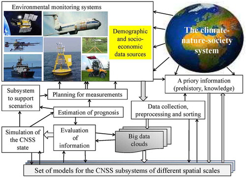
Construction of the GIMS is connected with consideration of the components of the biosphere, climate, and social medium characterized by the given level of spatial hierarchy. Realization of the GIMS function is provided by its subsystems listed in . Basic block of the GIMS is the CNSS global simulation model (CNSSGSM), the structure of which is shown in . The CNSSGSM assimilates big data fluxes considering complex of biospheric, climatic, and socioeconomic processes taking into account their space-temporal hierarchy. According to the procedure represented in , the CNSSGSM structure is oriented on the adaptive functioning mode introducing the global model into a system of geoinformation monitoring (Krapivin & Kelley, Citation2009; Krapivin & Shutko, Citation2012). The approach to the CNSSGSM synthesis is based on the two mathematical methods:
Balance equations are used when knowledge of fluxes of matters and information between CNSS components are exhaustive.
Evolutionary algorithm is applied when the build-up of an adequate balance model is, in principle, impossible because of the lack of information completeness and knowledge of environmental and socioeconomic laws are insufficient.
Table 1. The GIMS functions and their short description.
Figure 3. The structure of the CNSSGSM.
Source: Kondratyev, Krapivin, and Phillips (Citation2002) and Krapivin et al. (Citation2015)
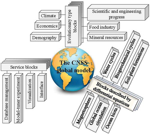
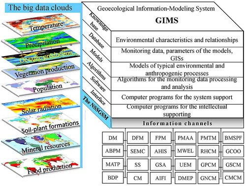
Figure 4. The GIMS/NSSGSM block-diagram.
Note: The explanation of abbreviations is given in .
4. Examples of global big data processing
Interaction level of society and nature has reached global planetary scales when anthropogenic impacts on the natural subsystems and processes become the dangerous changes of the habitat both for animals and peoples. There is only a single approach to the search for CNSS sustainable development, which consists in the evaluation of the consequences of anthropogenic scenario realization by means of simulation experiments. The GIMS approach can help in these experiments allowing the estimation of environmental consequences from anthropogenic scenarios realization, including global and regional scales of the impacts. Variety of these impacts covers practically all environments including pollution of the atmosphere and hydrosphere at the expense of the release of toxic compounds into the environment, the destruction of habitats through agriculture and urban sprawl, agricultural expansion to the forested areas, etc. In other words, human society aiming at living comfort, depletes the resources, destroys the vegetable kingdom and animal word, and pollutes the environment. To demonstrate the GIMS functions, several scenarios of the forest areas reconstruction are considered. Mainly, the GIMS could realize different scenarios that are harmonized with our understanding of possible effects on the environment.
The land cover is characterized by the heterogeneity of biomes and other environmental objects. At present the main areas of the land are woodland (41.2%) and cropland (24.7%). The land use is a basic problem and the solution of which involves the management and modification of the natural environment which mainly relates to the reduction of the forest areas (Kargel, Leonard, Bishop, Kaab, & Raup, Citation2014; Lambin & Geist, Citation2006; Ramachandran & Garrity, Citation2012). Unfortunately, the forest areas are subject to the realistic implementation of anthropogenic scenarios associated with the withdrawal of their biomass.
It is known that boreal and tropical forest undergo the most anthropogenic impacts. The phenomenon of wildfire by lightning strike or by human actions is the primary determinant of the forests. The GIMS allows for the realization of different scenarios of influence on these forests with spatial resolution 1 × 1 (Hengeveld et al., Citation2015).
Simulation experiments show that total burning of all coniferous forests up to 42°N leads to an increase of atmospheric carbon by 21.7% with increasing global temperature by 4 °C. During the next year, the oceans absorb 10% of the emitted carbon and during the next century only 1.3% of the increased atmospheric carbon has remained in the atmosphere. The system atmosphere–ocean over 100 years goes to the carbon balance and carbon content in the deep ocean increase by 9% (Krapivin et al., Citation2017a). Realized impact on the coniferous forests is reflected in the humus layer dynamics, that over 30 years, has lost 4% of its reserves. Fired coniferous forests are restored during 100 years by 68%. Other forests absorb 1/30 part of emitted carbon.
Tables – show the estimates of variations of carbon reserves in basic biospheric reservoirs when forests of different climatic zones are partially burned. It is seen that large-scale impacts on the land biota are damped during 60–100 years. Under this biosphere is more stable to the impacts on the tropical forests than on boreal forests. Simulation results show that the forests of the Northern Hemisphere (42°N and higher) play a significant stabilization role in the global carbon cycle. Within these scenarios it is assumed that the forest areas during post-fire restoration covered by the same plants. Certainly, post-fire restoration leads to a new forest structure and other species diversity which is the result of many environmental processes including global climate change and natural forest succession.
Table 2. The GIMS evaluations of the variations in the carbon reserve under conditions when the coniferous forests of the Northern latitudes (up to 42°N) are burned.
Table 3. Model evaluations of the variations in the carbon reserve when all the forests of the Northern latitudes up to 42°N are partially burned.
Table 4. Model estimation of the variations in the carbon reserve when the forests of the tropical latitudes are partially burned.
shows the change of vegetation role in the atmospheric carbon absorption under the reconstruction of soil–plant formations. Anthropogenic change of vegetation covers can significantly change balance components of global carbon cycle. It is clear that such hypothetical vegetation cover transformations need to take into account climatic zones and biological compatibility. The GIMS partly helps to realize similar simulation experiments.
Table 5. The dynamics of the ratio of the integral rates of CO2 assimilation by vegetation covers from the atmosphere in the context of the scenario when natural biome is globally replaced by other biome.
The GIMS gives the opportunity to evaluate the mosaic picture of the carbon dioxide sinks in the vegetation biomes in its dynamics. The knowledge of this mosaic makes it possible to assess the role of concrete biomes in the regional balance of carbon and on this basis, to estimate the possible consequences from anthropogenic interference in these biomes. The GIMS gives an opportunity to estimate the atmospheric CO2 sequestration by vegetation sites in their evolution on different territories. It is assumed that CO2 emissions in 2015 are estimated by 36.1 GtCO2 globally and 1.7 GtCO2 from the Russian territory with consecutive decrease by 10% to 2150. As well as it is accepted that deforestation processes on Russian territory are no realized. In the context of this scenario, rates of CO2 assimilation by plants on the territory of Russia will increase from 206.1 MtC/year in 2015 to 292.3 MtC/year in 2150 which is a result of climate change. Under this role of arctic deserts and tundras are characterized by the increase from 2000 to 2150 by 256%. Global warming effects on these biomes are shown in the expansion of the vegetation period and transformation plant types at the expense of the tundra–taiga boundary succession processes. Such effects are reduced for the mid-taiga forests and dry steppes up to 205 and 114%, respectively.
Natural land cover transformations are real processes that are realized by humans for the improvement of living habitat and food production growth. These actions lead to the change of many evolutionary processes, including changes in biogeochemical cycles, which directly leads to climate change. demonstrates some modeling results when various biomes are transformed. Such hypothetical experiments lead to the understanding of the limits of natural stability and to the possible ranges of anthropogenic interventions to the natural environments.
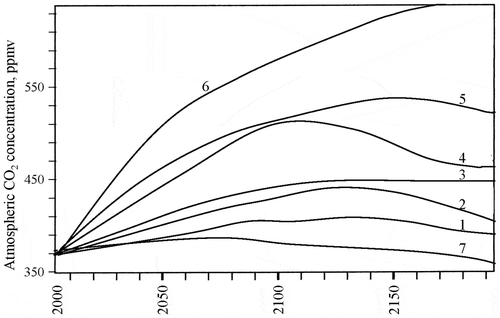
Simulation experiments show significant dependence of global climate on the overall health of global forests. For example, the reduction of global forested areas by 19% to 2050 leads to the CO2 concentration increase by 53% by the end of twenty-first century and, on the contrary, increase of forested areas by 10% during the same time period gives a CO2 concentration decrease by 12%. represents a climate change within realization of different scenarios for the impacts on forests. We see that forests and climate are intrinsically linked significantly through the sequestering atmospheric carbon as well as through direct and indirect impacts on the global hydrological cycle (Roberts, Citation2009).
Figure 5. The dynamics of the CO2 concentration for different scenarios of changing forest areas in the context of possible scenarios: 1 by 2050 the area of the forests is increased by 5% and remains without changes; 2 by 2050 the area of the forests is reduced by 5%; 3 by 10%; 4 by 20%; 5 by 30%; 6 by 2050 the forests will be liquidated at all; 7 by 2050 the area of the forests is increased by 50% without change in the future.
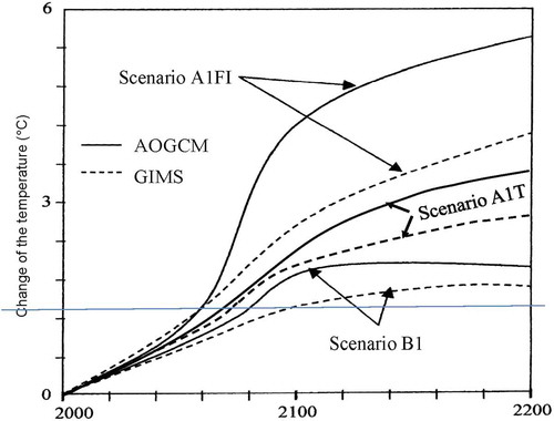
The GIMS reflects the interactions of natural and anthropogenic factors that play a significant role in the greenhouse effect formation depending on the energy use and economic development. gives a comparison of modeling results regarding the future global temperature change under the realization of IPCC scenarios. It is evident that the GIMS forecasts more low deviations in average global temperature compared to results from the atmosphere–ocean general circulation model (AOGCM) of Hadley Centre. For example, the realization of the A1FI pessimistic scenario is geared to a very rapid economic growth and intensive use of fossil resources, giving the global temperature rise to 2100 by 4 and 2.6 °C according to AOGCM and GIMS, respectively. But these changes to 2200 are 5.5 and 4 °C, respectively. The conclusion that can be drawn from the results of is that GIMS gives more precise results due to more broad components taking into consideration.
Figure 6. Prognoses of the changes in average global temperature evaluated by means of AOGCM and GIMS within three IPCC emission scenarios.
5. Conclusions
Co-evolution of climate, biosphere, geosphere, hydrosphere, and human society depends on how the Earth’s system generates and maintains thermodynamic imbalance. Understanding and evaluating processes in the climate–nature–society system requires the big data processing algorithms under the exponential growth of them and when using traditional data processing tools eventually become obsolete. Most of the existing climate models and global biospheric models do not provide overall analysis of the processes existent in the Earth system. The GIMS as it is seen in and can play the role of the Big Data information-modeling system that at one time can analyze heterogeneous data delivered by different monitoring systems with incongruous scales and un-removable uncertainties. Tables – demonstrate such functions of the GIMS as a new Big Data Approach.
Table 6. The GIMS/NSSGSM functional blocks.
As a result of simulation results, there are significant impacts of the saturation of greenhouse effect due to CO2 growth, which is agreed with the physical laws and is justified by many modeling results (Miskolczi, Citation2007). Simulation experiments analogous to can help to search for optimal forest management strategy when climate change forecast will be acceptable for a long time. Certainly, this paper cannot solve this task. It is necessary to realize series of simulation experiments with consideration of reasonable scenarios (Krapivin et al., Citation2017b).
Moreover, the GIMS possesses the data fusion function when data are delivered from dissimilar sources by irregularly in time and fragmentary by space. This function allows for the answer on the following questions that inevitable arisen under environmental monitoring management (Nitu, Krapivin, & Soldatov, Citation2013; Krapivin, & Shutko, Citation2012):
What tools, remote sensing platforms, and instruments should be used to form the GIMS database?
What is the cost of information for the GIMS simulation experiment?
What balance should be between different data sources?
This paper describes the main structure of GIMS and gives examples of its use to demonstrate functional efficiency of the big data analysis and processing. Scenarios that are studied here show the presence of alternatives in environmental anthropogenic strategies.
Disclosure statement
No potential conflict of interest was reported by the authors.
Funding
This study was partly supported by the Russian Fund for Basic Researches [Project No. 16-01-000213-a].
Data availability statement
The data that support the findings of this study are presented in two books at http://www.springer.com/la/book/9783319139777 (doi: 10.1007/978-3-319-13978-4) and http://www.springer.com/us/book/9783540706618#otherversion=9783642089596 (doi: 10.1007/978-3-540-70662-5).
References
- Ammn, N., & Infanuddin, M. (2013). Big Data challenges. International Journal of Advanced Trends in Computer Science and Engineering, 2(1), 613–615.
- Bartsev, S. I., Degermendzhi, A. G., & Erokhin, D. V. (2008). Principle of the worst scenario in the modelling past and future of biosphere dynamics. Ecological Modeling, 216, 160–171.10.1016/j.ecolmodel.2008.03.002
- Baumann, P., Mazzetti, P., Ungar, J., Barbera, R., Barboni, D., Beccati, A., Bigagli, L., … Campalani, P. (2016). Big Data analytics for Earth sciences: The Earth server approach. International Journal of Digital Earth, 9(1), 3–29.10.1080/17538947.2014.1003106
- Belaud, J.-P., Negny, S., Dupros, F., Michéa, D., & Vautrin, B. (2014). Collaborative simulation and scientific big data analysis: Illustration for sustainability in natural hazards management and chemical process engineering. Computers in Industry, 65(3), 521–535.10.1016/j.compind.2014.01.009
- Cracknell, A. P., & Varotsos, C. A. (1994). Ozone depletion over Scotland as derived from Nimbus-7 TOMS measurements. International Journal of Remote Sensing, 15(13), 2659–2668.10.1080/01431169408954273
- Cracknell, A. P., & Varotsos, C. A. (1995). The present status of the total ozone depletion over Greece and Scotland: A comparison between Mediterranean and more northerly latitudes. International Journal of Remote Sensing, 16(10), 1751–1763.10.1080/01431169508954515
- Cracknell, A. P., & Varotsos, C. A. (2007). Editorial and cover: Fifty years after the first artificial satellite: From Sputnik 1 to ENVISAT. International Journal of Remote Sensing, 28(10), 2071–2072.10.1080/01431160701347147
- Cracknell, A. P., & Varotsos, C. A. (2011). New aspects of global climate-dynamics research and remote sensing. International Journal of Remote Sensing, 32(3), 579–600.10.1080/01431161.2010.517807
- Cracknell, A. P., Krapivin, V. F., & Varotsos, C. A. (Eds.). (2009a). Global climatology and ecodynamics: Anthropogenic changes to planet Earth (p. 518). Chichester: Springer/Praxis.
- Cracknell, A. P., Krapivin, V. F., & Varotsos, C. A. (2009b). Sustainable development problems in the context of global ecodynamics. In A. P. Cracknell, V. F. Krapivin, & C. A. Varotsos (Eds.), Problems of global climatology and ecodynamics (pp. 445–477). Chichester: Springer/Praxis.10.1007/978-3-540-78209-4
- Craglia, M., de Bie, K., Jackson, D., Pesaresi, M., Remetey-Fülöpp, G., Wang, C., … van Genderen. J. (2012). Digital Earth 2020: Towards the vision for the next decade. International Journal of Digital Earth, 5(1), 4–21.10.1080/17538947.2011.638500
- Dao, V. T., Nguyen, X. M., Le, T. T. V., Krapivin, V. F., Mkrtchyan, F. A., Nguyen, T. H., … Le, N. H. (2015). Global model of carbon cycle as instrument of primary agriculture production assessment. In Proceedings of the International Symposium “Some Aspects of Contemporary Issues in Ecoinformatics (pp. 50–58), 20 March 2015, Hochiminh City. Institute of Applied Mechanics and Informatics, Vietnam Academy of Science and Technology.
- Degermendzhi, A. G., Bartsev, S. I., Gubanov, V. G., Erokhin, D. V., & Shevirnogov, A. P. (2009). Forecast of biosphere dynamics using small-scale mo dels. In A. P. Cracknell, V. F. Krapivin, & C. A. Varotsos (Eds.), Global climatology and ecodynamics (pp. 241–300). Chichester: Springer/Praxis.10.1007/978-3-540-78209-4
- Dhamodaran, S., Sachin, K. R., & Kumar, R. (2015). Big Data implementation of natural disaster monitoring and alerting system in real time social network using Hadoop technology. Indian Journal of Science and Technology, 8(22). doi:10.17485/ijst/2015/v8i22/79102
- Edwards, P. N. (2010). A vast machine: Computer models, climate data, and the politics of global warming (p. 518). Cambridge, MA: MIT Press.
- Efstathiou, M., Varotsos, C., & Kondratyev, K. Y. (1998). An estimation of the surface solar ultraviolet irradiance during an extreme total ozone minimum. Meteorology and Atmospheric Physics, 68(3), 171–176.10.1007/BF01030208
- Efstathiou, M. N., & Varotsos, C. A. (2010). On the altitude dependence of the temperature scaling behaviour at the global troposphere. International Journal of Remote Sensing, 31, 343–349.10.1080/01431160902882702
- Efstathiou, M. N., Varotsos, C. A., Singh, R. P., Cracknell, A. P., & Tzanis, C. (2003). On the longitude dependence of total ozone trends over middle-latitudes. International Journal of Remote Sensing, 24(6), 1361–1367.10.1080/0143116021000044814
- Efstathiou, M. N., Tzanis, C., Cracknell, A. P., & Varotsos, C. A. (2011). New features of land and sea surface temperature anomalies. International Journal of Remote Sensing, 32(11), 3231–3238.10.1080/01431161.2010.541504
- Evangelinos, C., & Hill, C. (2008). Cloud computing for parallel scientific HPC applications: Feasibility of running coupled atmosphere-ocean climate models on Amazon’s. EC2 Ratio, 2, 2–34.
- Gernandt, H., Goersdorf, U., Claude, H., & Varotsos, C. A. (1995). Possible impact of polar stratospheric processes on mid-latitude vertical ozone distributions. International Journal of Remote Sensing, 16(10), 1839–1850.10.1080/01431169508954523
- Goodchild, M. F., Guo, H., Annoni, A., Bian, L., de Bie, K., Campbell, F., … Lewis, M. A. J. (2012). Next-generation Digital Earth. Proceedings of the National Academy of Sciences, 109(28), 11088–11094.10.1073/pnas.1202383109
- Guo, H., Wang, L., & Liang, D. (2016). Big Earth Data from space: A new engine for Earth science. Science Bulletin, 61(7), 505–513.10.1007/s11434-016-1041-y
- Guo, H., Wang, L., Chen, F., & Liang, D. (2014). Scientific big data and Digital Earth. Chinese Science Bulletin, 59(35), 5066–5073.10.1007/s11434-014-0645-3
- Guo, H., Liu, Z., Jiang, H., Wang, C., Liu, J., & Liang, D. (2017). Big Earth Data: A new challenge and opportunity for Digital Earth’s development. International Journal of Digital Earth, 10(1), 1–12.
- Held, D, & McGrew, A (2007a). Globalization theory: Approaches and controversies (p. 288). Cambridge: Polity Press.
- Held, D., & McGrew, A. (2007b). Globalization/anti-globalization: Beyond the great divide (p. 304). Cambridge: Polity Press.
- Hengeveld, G. M., Gunia, K., Didion, M., Zudin, S., Clerkx, A. P. P. M., & Schelhaas, M. J. (2015). Global 1-degree maps of forest area, carbon stocks, and biomass, 1950–2015. Oak Ridge, TN: ORNL DAAC. doi:10.3334/ORNLDAAC/1296
- Kargel, J. S., Leonard, G. J., Bishop, M. P., Kaab, A., & Raup, B. H. (Eds.). (2014). Global land use managements from space (p. 876). Berlin: Springer.
- Kondratyev, K. Y., Ivlev, L. S., Krapivin, V. F., & Varotsos, C. A. (2006). Atmospheric aerosol properties: Formation, processes and impacts (p. 572). Chichester: Springer/Praxis.
- Kondratyev, K. Y., Krapivin, V. F., & Phillips, G. W. (2002). Global environmental change: Modelling and monitoring (p. 319). Berlin: Springer-Verlag.10.1007/978-3-662-04941-9
- Kondratyev, K. Y., Krapivin, V. F., & Phillips, G. W. (2003). Arctic Basin pollution dynamics. In L. P. Bobylev, K. Y. Kondratyev, & O. M. Johannesses (Eds.), Arctic environment variability in the context of global change (pp. 309–362). Chichester: Springer/Praxis.
- Kondratyev, K. Y., Krapivin, V. F., Savinykh, V. P., & Varotsos, A. (2004). Global ecodynamics: A multidimensional analysis (658 p.). Chichester: Springer/Praxis.10.1007/978-3-642-18636-3
- Kondratyev, K. Y., Krapivin, V. F., & Varotsos, C. A. (2003). Global carbon cycle and climate change (p. 372). Chichester, U. K.: Springer/Praxis.
- Kondratyev, K. Y., Varotsos, C. A., & Cracknell, A. P. (1994). Total ozone amount trend at St Petersburg as deduced from Nimbus-7 TOMS observations. International Journal of Remote Sensing, 15(13), 2669–2677.10.1080/01431169408954274
- Krapivin, V. F. (1993). Mathematical model for global ecological investigations. Ecological Modelling, 67(2–4), 103–127.10.1016/0304-3800(93)90001-9
- Krapivin, V. F. (1996). The estimation of the Peruvian current ecosystem by a mathematical model of biosphere. Ecological Modelling, 91, 1–14.10.1016/0304-3800(95)00155-7
- Krapivin, V. F. (2009). Technology for the synthesize of geoecological information-modeling systems (GIMS-technology). Journal of Science and Technology, 1, 47–55.
- Krapivin, V. F., & Kelley, J. J. (2009). Model-based method for the assessment of global change in a nature-society system. In A. P. Cracknell, V. F. Krapivin, and C. A. Varotsos (Eds), Global climatology and ecodynamics (pp. 133–183). Chichester: Springer/Praxis.10.1007/978-3-540-78209-4
- Krapivin, V. F., & Shutko, A. M. (2012). Information technologies for remote monitoring of the environment (p. 498). Chichester: Springer/Praxis.10.1007/978-3-642-20567-5
- Krapivin, V. F., Shutko, A. M., Chukhlantsev, A. A., Golovachev, S. P., & Phillips, G. W. (2006). GIMS-based method for vegetation microwave monitoring. Environmental Modelling and Software, 21(3), 330–345.10.1016/j.envsoft.2004.11.005
- Krapivin, V. F., & Soldatov, V. Y. (2014). The organic carbon cycle in conditions of freezing seas. In Proceedings of the 29-th International Symposium on Okhotsk Sea and Sea Ice (pp. 275–278), 16–19 February 2014, Mombetsu. The Okhotsk Sea and Cold Ocean Research Association.
- Krapivin, V. F., Soldatov, V. Y., Varotsos, C. A., & Cracknell, A. P. (2012). An adaptive information technology for the operative diagnostics of the tropical cyclones; solar-terrestrial coupling mechanisms. Journal of Atmospheric and Solar-Terrestrial Physics, 89, 83–89.10.1016/j.jastp.2012.08.009
- Krapivin, V. F., & Varotsos, C. A. (2007). Globalization and sustainable development (p. 304). Chichester: Springer/Praxis.
- Krapivin, V. F., & Varotsos, C. A. (2008). Biogeochemical cycles in globalization and sustainable development (p. 562). Chichester: Springer/Praxis.
- Krapivin, V. F., & Varotsos, C. A. (2016). Modelling the CO2 atmosphere-ocean flux in the upwelling zones using radiative transfer tools. Journal of Atmospheric and Solar-Terrestrial Physics, 150–151, 47–54.10.1016/j.jastp.2016.10.015
- Krapivin, V. F., Varotsos, C. A., & Soldatov, V. Y. (2015). New ecoinformatics tools in environmental science: Applications and decision-making (p. 903). London: Springer.
- Krapivin, V. F., Varotsos, C. A., & Soldatov, V. Y. (2017a). Simulation results from a coupled model of carbon dioxide and methane global cycles. Ecological Modelling, 359, 69–79.10.1016/j.ecolmodel.2017.05.023
- Krapivin, V. F., Varotsos, C. A., & Soldatov, V. Y. (2017b). The Earth’s population can reach 14 billion in the 23rd century without significant adverse effects on survivability. The International Journal of Environmental Research and Public Health, 14(8), 3–18.
- Lambin, E. F., & Geist, H. J. (Eds.). (2006). Land-use and land-cover change: Local processes and global impacts (p. 222). London: Springer.
- Mintzer, I. M. (1987). A matter of degrees: The potential for controlling the greenhouse effect ( World Resources Institute Research Report Number 15, p. 70). Maryland: United States Department of Agriculture, National Agricultural Library. Retrieved form http://agris.fao.org/agris-search/search.do?recordID=US9006565
- Miskolczi, F. M. (2007). Greenhouse effect in semi-transparent planetary atmosphere. Quartely Journal of the Hungarian Meteorological Journal, 111(1), 1–40.
- Nitu, C., Dumitrasku, A., Krapivin, V. F., & Mkrtchyan, F. A. (2015). Reducing risks in agriculture. In Proceedings of the 20th International Conference on Control Systems and Computer Science (pp. 941–945), 27–29 May 2015, Bucharest: University Politehnica of Bucharest Campus.
- Nitu, C., Krapivin, V. F., & Pruteanu, E. (2004). Ecoinformatics: Intelligent systems in ecology (p. 411). Bucharest: Magic Print Onesti.
- Nitu, C., Krapivin, V. F., & Soldatov, V. Y. (2013). Information-modeling technology for environmental investigations (p. 621). Bucharest: Matrix Rom.
- Olivier, J. G. J., Janssens-Maenhout, G., Muntean, M., & Peters, J. A. H. W. (2016). Trends in global CO2 emissions: 2016 report (p. 81). Netherlands: PBL.
- Ramachandran, N. P. K., & Garrity, . (Eds.). (2012). Agroforestry – the future of global land use (p. 542). Netherlands: Springer.
- Reid, S. J., Rex, M., von Der Gathen, P., Fløisand, I., Stordal, F., Carver, G. D., … Braathen, G. (1998). A Study of Ozone Laminae Using Diabatic Trajectories, Contour Advection and Photochemical Trajectory Model Simulations. Journal of Atmospheric Chemistry, 30(1), 187–207.10.1023/A:1005836212979
- Reid, S. J., Vaughan, G., Mitchell, N. J., Prichard, I. T., Smit, H. J., Jorgensen, T. S., … De Backer, H. (1994). Distribution of ozone laminae during EASOE and the possible influence of inertia-gravity waves. Geophysical Research Letters, 21(13), 1479–1482.10.1029/93GL01676
- Roberts, J. M. (2009). The role of forests in the hydrological cycle. In J. M. Roberts, & H. G. Lund (Eds.), Forests and forest plants. Volume III. Centre for Forest Biology (pp. 42–76). Canada: University of Victoria.
- Sellers, P. J., Mintz, Y., Sud, Y. C., & Dalcher, A. (1986). A simple biosphere model (SIB) for use within general circulation models. Journal of the Atmospheric Sciences, 43(6), 505–531.10.1175/1520-0469(1986)043<0505:ASBMFU>2.0.CO;2
- Soldatov, V. Y. (2010). A sequential analysis method for the prediction of tropical hurricanes (typhoons). In Proceedings of the Ninth International Symposium “Ecoinformatics Problems” (pp. 80–89), 9–11 December, Moscow. The Moscow Sciences Engineering A.S. Popov Society for Radio, Electronics and Communication.
- Soldatov, V. Y. (2015). Remote sensing monitoring of the atmosphere-ocean system as generator of tropical cyclones. In Proceedings of the 30th International Symposium on Okhotsk Sea & Sea Ice (pp. 199–202), 15–19 February 2015, Mombetsu: The Okhotsk Sea & Cold Ocean Research Association.
- Sudmanns, M., Tiede, D., Lang, S., & Baraldi, A. (2017). Semantic and syntactic interoperability in online processing of big Earth observation data. International Journal of Digital Earth, 1–18. doi:10.1080/17538947.2017.1332112
- Tzanis, C., Varotsos, C., & Viras, L. (2008). Impacts of the solar eclipse of 29 March 2006 on the surface ozone concentration, the solar ultraviolet radiation and the meteorological parameters at Athens, Greece. Atmospheric Chemistry and Physics, 8(2), 425–430.10.5194/acp-8-425-2008
- Varotsos, C. (2002). The southern hemisphere ozone hole split in 2002. Environmental Science and Pollution Research, 9(6), 375–376.10.1007/BF02987584
- Varotsos, C. (2005). Modern computational techniques for environmental data; application to the global ozone layer. Computational Science–ICCS 2005, 43–68.
- Varotsos, C., & Cartalis, C. (1991). Re-evaluation of surface ozone over Athens, Greece, for the period 1901–1940. Atmospheric Research, 26(4), 303–310.10.1016/0169-8095(91)90024-Q
- Varotsos, C. A., & Cracknell, A. P. (1993). Ozone depletion over Greece as deduced from Nimbus-7 TOMS measurements. International Journal of Remote Sensing, 14(11), 2053–2059.10.1080/01431169308954021
- Varotsos, C. A., & Cracknell, A. P. (1994). Three years of total ozone measurements over Athens obtained using the remote sensing technique of a Dobson spectrophotometer. International Journal of Remote Sensing, 15(7), 1519–1524.10.1080/01431169408954181
- Varotsos, C. A., & Cracknell, A. P. (2004). New features observed in the 11-year solar cycle. International Journal of Remote Sensing, 25(11), 2141–2157.10.1080/0143116031000115067
- Varotsos, C. A., & Tzanis, C. (2012). A new tool for the study of the ozone hole dynamics over Antarctica. Atmospheric Environment, 47, 428–434.10.1016/j.atmosenv.2011.10.038
- Varotsos, C., Kalabokas, P., & Chronopoulos, G. (1994). Association of the laminated vertical ozone structure with the lower-stratospheric circulation. Journal of Applied Meteorology, 33(4), 473–476.10.1175/1520-0450(1994)033<0473:AOTLVO>2.0.CO;2
- Varotsos, C., Kondratyev, K. Y., & Katsikis, S. (1995). On the relationship between total ozone and solar ultraviolet radiation at St. Petersburg, Russia. Geophysical Research Letters, 22(24), 3481–3484.10.1029/95GL03172
- Varotsos, C. A., Kondratyev, K. Y., & Cracknell, A. P. (2000). New evidence for ozone depletion over Athens, Greece. International Journal of Remote Sensing, 21(15), 2951–2955.10.1080/01431160050121366
- Varotsos, C. A., Krapivin, V. F., & Soldatov, V. Y. (2014). Modeling the carbon and nitrogen cycles. Frontiers in Environmental Science: Air Pollution, 2(8), 1–6. doi:10.3389/fenvs.2014.00008
- Varotsos, C., Efstathiou, M., & Tzanis, C. (2009). Scaling behaviour of the global tropopause. Atmospheric Chemistry and Physics, 9(2), 677–683.10.5194/acp-9-677-2009
- Zhong, Y., Zhang, L., Xing, S., Li, F., & Wan, B. (2014). The Big Data processing algorithm for water environment monitoring of the Three Gorges Reservoir Area. Hindawi Publishing Corporation, Abstract and Applied Analysis, 698(632), 1–7, Article ID.