
Abstract
Earth observation community has entered into the era of big data. Family of Landsat sensors have collected massive medium resolution satellite images, which are valuable for long-term land surface monitoring. In order to significantly reduce the magnitude of data processing for remote sensing data users, Landsat-based Ready to Use (RTU) products have been produced. Main RTU products, including orthorectified products, land surface reflectance, land surface temperature, large-area mosaic image, and standard image map products, are described. The resulting Landsat RTU products are hosted on the RSGS earth observation data sharing web site for free download (http://ids.ceode.ac.cn/rtu/). These new products will provide consistent, standardized, multi-decadal image data for robust land cover change detection and monitoring across the Earth sciences. In the coming years, CASEarth DataBank system will be constructed, which is an intelligent data service platform for providing not only the RTU products from multi-source satellite data, but also big earth data analysis methods.
1. Introduction
Landsat series satellites provide the world’s longest continuous moderate-resolution remotely sensed data, which have been collecting measurements suitable for monitoring land cover and change since 1972. With more than 45 years of data storage, Landsat archive is valuable for analyzing long-term land surface dynamics and becomes the most widely used medium-resolution satellite data in the remote sensing community. China Remote Sensing Satellite Ground Station (RSGS) was established and put into operation in 1986. As a member of international ground stations group on Earth observation, RSGS has received, processed, and archived more than 30 satellites, including Landsat, SPOT, CBERS, etc. with over 4 million scenes of satellite data since 1986, of which Landsat series imageries cover more than 700,000 scenes, boasting China’s biggest Earth observation historical database. The prolific creation of Earth observation data accelerates humankind’s entrance into the era of big earth data (Guo, Citation2017a; Guo, Wang, Chen, & Liang, Citation2014; Guo et al., Citation2017c). Earth observation big data, as a subset of big earth data, is the basis of data-intensive scientific discovery in the Earth sciences. It is characterized as being massive, highly complex, multi-temporal, multi-source, heterogeneous, et al. which poses great challenges to data processing. However, in the long history of Landsat missions, standard Landsat imagery products have been provided by RSGS in systematically geometric and radiometric correction products (level 2 products), which is impossible to perform comparisons of Landsat data over space and time and to data from other sensors and brings great burdens of data processing to data users (Zhang et al., Citation2017). In order to significantly reduce the magnitude of data processing for Landsat users, higher-level Landsat data products (named Ready To Use (RTU) products) have been generated by RSGS from 2013 with the support of the 135 strategy planning programme of the Chinese academy of sciences (He, Wang, Ma, & Zhang, Citation2015). Based on original Landsat level 2 data, the RTU products are consistently processed to higher scientific standards and level of processing and can be directly used in a variety of fields. Landsat RTU products covering the entire area of China and centered on 2000, 2005, 2010, and 2015, have been provided and can be downloaded freely from the website (http://ids.ceode.ac.cn/rtu/). In 2017, a new project entitled “Big Earth Data Science Engineering (CASEarth)” in the Strategic Priority Research Program (SPRP) of the Chinese Academy of Sciences (Guo, Citation2017b) was launched. Through this project, all RSGS received Landsat imageries will be processed to RTU products in the coming years, and the CASEarth DataBank system will be constructed, which is an intelligent data service platform for providing not only the RTU products from multi-source satellite data, but also big earth data analysis methods. In the next section, main RTU products released by RSGS in recent years will be described.
2. Main RTU products and generation algorithms
2.1. Ortho-rectified Products
Ortho-rectified products are georeferenced images which have been processed by removing the effects of image perspective and relief effects with the help of accurate ground control points (GCP) and digital elevation model (DEM) data. Limited by the accuracy of satellite attitude and orbit control system (AOCS), the direct positioning accuracy (without ground control) of space-borne optical sensor cannot meet the application requirements. As the geometric deviation of satellite image not only leads to the spatial discrepancy of time series remote sensing data, but also affects the location and information of ground target, geometric standardization is essential for long-time Landsat series satellite RTU products. For this sake, several types of data sources, including Landsat-8 ortho-images (From USGS, https://earthexplorer.usgs.gov), high-precision ground control point database, higher-resolution images and online map (such as Google Map and Bing Map) (Long, Jiao, He, & Zhang, Citation2016), are used as reference data, and phase correlation-based matching approach (Dong, Long, Jiao, He, & Zhang, Citation2018) is adopted to find both control points from reference data and tie points between the images with sub-pixel precision, followed by random sample consensus algorithm (RANSAC) to eliminate the false matching points; for low texture area where the corresponding points with high-precision are difficult to obtain, line-feature and region-feature can also be utilized as control features (Long, Jiao, & Wang, Citation2013; Long et al., Citation2015). After automatic image matching, control points, control features, and tie points are integrated to perform block adjustment of large-scale to optimize the rigorous geometric imaging model of Landsat-5 and Landsat-7 images. Block adjustment guarantees the absolute positioning accuracy of images as well as the relative geometric accuracy among images, and finally, with the help of the global DEM data, the satellite images are orthorectified using the optimized geometric imaging model.
2.2. Land surface reflectance
Land surface reflectance (LSR) is defined as the ratio of outgoing radiance to the total down-welling irradiance, which provides a more robust representation of Earth’s surface over varying external conditions. LSR can be obtained from at-sensor radiance by performing atmospheric correction to remove the influences of atmospheric absorption and scattering. Various atmospheric correction algorithms have been proposed in the literature, for example radiative transfer model (RTM) (MODTRAN and 6S) (Liang, Fang, & Chen, Citation2001; Vermote, Tanre, Deuze, Herman, & Morcette, Citation1997; Wilson, Citation2013), dark object subtraction (DOS)-based method (Chavez, Citation1989; Zhang, He, & Wang, Citation2010; Zhang et al., Citation2017), invariant object method (Hall, Strebel, Nickeson, & Goetz, Citation1991), histogram matching method (Richter, Citation1996), and dense dark vegetation method (Liang et al., Citation1997), of which RTM and DOS-based methods are widely used (Masek et al., Citation2006; Song, Woodcock, Seto, Lenney, & Macomber, Citation2001; Zhang et al., Citation2017). 6S radiative transfer model has been adopted to generate LSR RTU products, which is physically based and has been approved to be an accurate way to retrieve LSR (Kotchenova, Vermote, Levy, & Lyapustin, Citation2008; Masek et al., Citation2006; Moran, Jackson, Slater, & Teillet, Citation1992). 6S model input parameters include the geometric conditions (solar zenith angle, solar azimuth angle, view zenith angle, and view azimuth angle), the atmospheric components such as total atmospheric water vapor content, ozone concentration, and aerosol optical depth. However, it is difficult to collect in situ atmospheric parameters measured contemporaneous with the satellite overpass, especially for historical satellite databases or in remote areas. In practice, we used some operational atmospheric products to obtain the atmospheric components required by the 6S model, such as using NOAA National Centers for Environmental Prediction reanalysis (NCEP) data available at a resolution of 2.5° × 2.5° to derive atmospheric water vapor, and using the Total Ozone Mapping Spectrometer (TOMS) data for ozone concentration with a resolution of 1.25-deg longitude and 1.00° latitude. To generate LSR RTU products from Landsat images acquired after 2000 year, Terra MODIS-derived atmospheric characterization data are employed as input parameters for the 6S model for their easy access and higher spatial resolution with daily global coverage, including MODIS total atmospheric water vapor content (MOD05) with a spatial resolution of 1 km, MODIS ozone concentration (MOD07) with a spatial resolution of 5 km, and MODIS aerosol optical depth (MOD04) with a spatial resolution of 10 km.
For consistent and comparable purpose, NCEP data, TOMS data, and aerosol optical thickness (AOT) extracted directly from the Landsat imagery (Masek et al., Citation2006) were used as auxiliary data of 6S model for Landsat5/7 LSR products generation, following a similar pipeline of Landsat Ecosystem Disturbance Adaptive Processing System (LEDAPS) at the NASA Goddard Space Flight Center (GSFC).
Normally, per-pixel atmospheric correction of Landsat 8 OLI imagery with the MODIS atmospheric parameters as inputs, the 6S model will be called about 2.4 × 10⁵ times benchmarked against 1 km spatial resolution. It is too time consuming and not suitable for operational Landsat 8 LSR RTU products generation. Therefore, a fast atmospheric correction algorithm for Landsat 8 OLI imagery is proposed based on Look Up Table (LUT) technique. In this approach, a high dimensional LUT considering most influencing factors (e.g. solar zenith, water vapor, ozone, and AOT) was built and the LUT has a high adaptability to the Landsat 8 OLI imagery. Thereby, Landsat 8 LSR RTU products can be generated operationally with both high accuracy and fast speed (Peng et al., Citation2016). In terms of the accuracy and consistence, we are considering generating the Landsat 8 LSR products with the algorithm developed by NASA/GSFC which directly retrieves AOT from the Landsat 8 imagery (Vermote, Justice, Claverie, & Franch, Citation2016).
2.3. Land surface temperature
Land Surface Temperature (LST) is a key parameter in the study of energy and water exchange between the atmosphere and the ground, which plays an important role in a variety of fields, such as evapotranspiration, net radiation, vegetation stress, and global change studies. Thermal infrared remote sensing provides a unique way to obtain LST with different spatial resolutions and periodicities. The launch of the Landsat series satellites has allowed the acquisition of a long-term medium spatial resolution thermal imagery which is important in many scientific studies. For Landsat 4, Landsat 5, and Landsat 7 satellite, there is only one thermal infrared channel, and only the single channel (SC) LST retrieval algorithm can be applied to derive LST. Although Landsat 8 Thermal Infrared Sensor (TIRS) has two thermal infrared bands located in 10.60–11.19 μm (Band 10) and 11.50–12.51 μm (Band 11), respectively. However, band 11 suffers from serious calibration uncertainty due to stray light effects, and it is not recommended for quantitative LST retrieval (Zhang et al., Citation2016a). Therefore, for Landsat series data, only the single channel algorithm can be adopted to obtain LST.
In general, single channel LST algorithm can be divided into three groups (Zhang et al., Citation2016b): (1) the radiative transfer equation (RTE), (2) the mono-window algorithm developed by Qin, Karnieli, and Berliner (Citation2001) (MW algorithm) (Qin et al., Citation2001), and (3) the generalized single-channel algorithm (GSC algorithm) (Jiménez-Muñoz & Sobrino, Citation2003; Jiménez-Muñoz et al., Citation2009).
The RTE method relies on in situ atmospheric profiles measured near the study area and near the satellite overpass time, which limit its application for a large region or operational use. The MW and GSC algorithms are developed based on approximations of thermal radiative transfer equation in order to avoid the dependence on in situ atmospheric profiles and, therefore, to obtain LST in a more operational way. The MW algorithm uses near-surface air temperature, the total atmospheric water vapor content (w), and land surface emissivity (LSE) as input parameters, whereas the GSC algorithm only needs w and LSE. The GSC algorithm requires the minimum input parameters and is most practical. In the past decade, much importance has been attached to the GSC algorithm (Lamaro, Mariñelarena, Torrusio, & Sala, Citation2013; Pandya et al., Citation2014; Zhang & He, Citation2013; Zhang et al., Citation2016b). Validation studies show the GSC algorithm can obtain a good accuracy (with root mean squared error less than 2 K) for w ranging from 0.5 to 2 g/cm2. However, when w was larger than 3 g/cm2, the accuracy of the GSC algorithm was unsatisfactory (Jiménez-Muñoz et al., Citation2009; Wang et al., Citation2016). In order to improve the accuracy of the GSC algorithm, an enhanced single channel algorithm (SCen) is proposed and employed in Landsat LST RTU products generation. Compared with the GSC algorithm, three new atmospheric functions are introduced in the SCen algorithm, and both the latitude and acquisition month of the Landsat image are considered in construction of the atmospheric function models. Validation results show the SCen algorithm can obtain higher accuracy than the GSC algorithm, especially under high atmospheric water vapor content conditions (Wang et al., Citation2016).
2.4. Large-area mosaic image product
Large-Area Mosaic (LAM) image products are generated by merging multiple Landsat standard scene images with overlapping areas into a single view with an indistinguishable seam line. The current mosaic procedure for LAM RTU product generation resolves several difficulties encountered in large area remote sensing image mosaicking, such as automatic and fast mosaicking for massive remotely sensed satellite data, and automatic color balancing technology which works from local to global areas. A Wavelet transform-based mosaicking method has been developed, which guarantees the image quality and color consistency of the LAM product. Specific LAM RTU products such as time-series mosaic maps of the whole China have been generated.
2.5. Standard image map product
Standard Image Map (SIM) product is generated by a series of image processing and map decoration. Compared with the traditional standard topographic maps, the SIM RTU products not only have the same positioning accuracy and Geo grid annotation, but also have more up-to-date and intuitive information. Specific SIM RTU products include remote sensing image map based on national topographic maps subdivisions at a scale of 1:1,000,000 and 1:250,000 and remote sensing image map based on China administrative divisions.
3. Application of RTU products
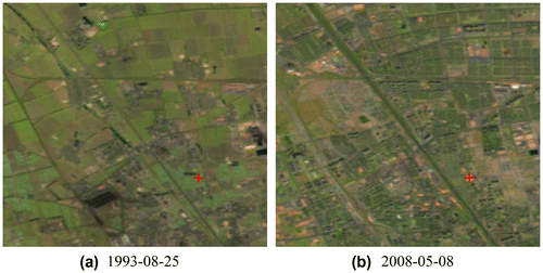
In this section, long time Landsat series imageries of Beijing city (path/row: 123/32) were employed to analyze long-term Normalized Difference Vegetation Index (NDVI) and LST dynamics from 1984 to 2013, and some useful conclusions can be drawn from this big earth data analysis. Figures and show NDVI and LST time series profiles of yongtai village in the north of Haidian District, Beijing, and Figure shows the Landsat-5 images acquired on 25 August 1993 and 8 May 2008 as well as the position for time series analysis. As can be seen from Figures , both NDVI and LST profiles changed dramatically through 1980s to 2010s and the turning points occurred around 1994 (in fact evident urbanization of the study area began around 1994), which demonstrates the temporal trends of these two important land surface parameters in the process of fast urbanization of Beijing city.
Figure 1. NDVI time series profile.
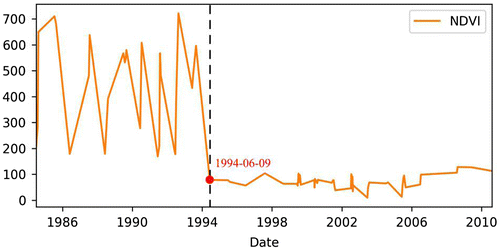
Figure 2. LST time series profile.
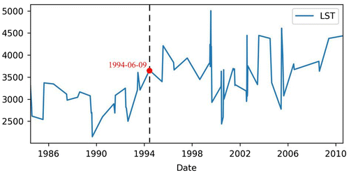
Figure 3. Landsat-5 images (SWIR1 band as red channel, NIR as green channel, and Red band as blue channel) before and after 1994, and red crossing shows the position for time series analysis.
4. Future activities
4.1. RTU producing plan
In the near future, the RTU products will be extended in spatial coverage, data sources, and product types. The spatial coverage of the RTU products will be extended from China and its surrounding areas to the global scale. The current RTU products are generated mainly based on Landsat series data, however, the future global RTU products will be produced using multi-source and multi-sensor data, such as Landsat, Sentinel, et al.; especially, the Chinese satellite data (HJ, GF, and CBERS) will be employed. Furthermore, some other RTU products are in development and will be provided in the following years. These products include LSR not only correcting for atmospheric effect, but also topographic and BRDF (Bidirectional Reflectance Distribution Function) effects, spectral indices like Normalized Difference Vegetation Index (NDVI), Enhanced Vegetation Index (EVI), Global Environment Monitoring Index (GEMI), etc., global forest cover, global burned area and global dynamic surface water extent.
4.2. CASEarth DataBank system construction
In the past decade, both the satellite Earth observation technology and the information technology have made rapid progress. In the coming years, the RTU products will be provided on the next generation architecture for earth observation data services-the CASEarth DataBank system. As new computing infrastructures, technologies and data architectures, the CASEarth DataBank system aims to meet the data management and analysis challenges arising from the huge increase in satellite earth observation data. The CASEarth DataBank system will be designed to increase the value and impact of RTU products by providing an open and freely accessible exploitation architecture and to broaden their applications for societal benefit.
4.3. Global grid model
For the CASEarth DataBank system, a global subdivision grid should be designed in order to effectively implement management, organization and usage of long time sequential RTU data, and facilitate the integration and application analysis of multi-source and multi-scale geospatial information, here we are thinking of designing global subdivision grid for RTU data based on the national standard (GB/T 12409-2009). The subdivision grid will be combined with the latitude and longitude grid and the Cartesian coordinate grid. The two types of grid have strict mathematical relations and can be converted to each other.
Funding
This work was supported by the Strategic Priority Research Program of the Chinese Academy of Sciences [grant number XDA19090300]; the National Key Research and Development Programs of China [grant numbers 2016YFA0600302 and 2016YFB0501502]; the program of the National Natural Science Foundation of China [grant number 61401461]; and 135 Strategy Planning of Institute of Remote Sensing and Digital Earth, Chinese Academy of Sciences.
Disclosure statement
No potential conflict of interest was reported by the authors.
Data availability statement
The data that support the findings of this study are available from the corresponding author upon reasonable request.
References
- Chavez, P. S. (1989). Radiometric calibration of Landsat thematic mapper multispectral images. Photogrammetric Engineering and Remote Sensing , 55 , 1285–1294.
- Dong, Y. , Long, T. , Jiao, W. , He, G. , & Zhang, Z. (2018). A novel image registration method based on phase correlation using low-rank matrix factorization with mixture of Gaussian. IEEE Transactions on Geoscience and Remote Sensing , 56 (1), 446–460. doi:10.1109/tgrs.2017.2749436
- Guo, H. (2017a). Big data drives the development of Earth science. Big Earth Data , 1 (1–2), 1–3.
- Guo, H. (2017b). Big Earth data: A new frontier in Earth and information sciences. Big Earth Data , 1 (1–2), 4–20.
- Guo, H. D. , Liu, Z. , Jiang, H. , Wang, C. , Liu, J. , & Liang, D. (2017). Big Earth data: A new challenge and opportunity for digital Earth’s development. International Journal of Digital Earth , 10 (1), 1–12.
- Guo, H. D. , Wang, L. Z. , Chen, F. , & Liang, D. (2014). Scientific big data and digital Earth. Chinese Science Bulletin , 59 (35), 5066–5073.10.1007/s11434-014-0645-3
- Hall, F. G. , Strebel, D. E. , Nickeson, J. E. , & Goetz, S. J. (1991). Radiometric rectification: Toward a common radiometric response among multidate, multisensor images. Remote Sensing of Environment , 35 , 11–27.10.1016/0034-4257(91)90062-B
- He, G. , Wang, L. , Ma, Y. , & Zhang, Z. (2015). Processing of earth observation big data: Challenges and countermeasures. Chinese Science Bulletin , 60 (5–6), 470–478.
- Jiménez-Muñoz, J. C. , Cristobal, J. , Sobrino, J. A. , Soria, G. , Ninyerola, M. , & Pons, X. (2009). Revision of the single-channel algorithm for land surface temperature retrieval from Landsat thermal-infrared data. IEEE Transactions on Geoscience and Remote Sensing , 47 (1), 339–349. doi:10.1109/TGRS.2008.2007125
- Jiménez-Muñoz, J. C. , & Sobrino, J. A. (2003). A generalized single-channel method for retrieving land surface temperature from remote sensing data. Journal of Geophysical Research: Atmospheres , 108 (D22), 4688–4695. doi:10.1029/2003JD003480
- Kotchenova, S. Y. , Vermote, E. F. , Levy, R. , & Lyapustin, A. (2008). Radiative transfer codes for atmospheric correction and aerosol retrieval: Intercomparison study. Applied Optics , 47 (13), 2215–2226. doi:10.1364/ao.47.002215
- Lamaro, A. A. , Mariñelarena, A. , Torrusio, S. E. , & Sala, S. E. (2013). Water surface temperature estimation from Landsat 7 ETM+ thermal infrared data using the generalized single-channel method: Case study of Embalse del Río Tercero (Córdoba, Argentina). Advances in Space Research , 51 , 492–500. doi:10.1016/j.asr.2012.09.032
- Liang, S. , Fallah-Adl, H. , Kalluri, S. , JáJá, J. , Kaufman, Y. J. , & Townshend, J. R. G. (1997). An operational atmospheric correction algorithm for Landsat thematic mapper imagery over the land. Journal of Geophysical Research , 102 , 17173–17186.10.1029/97JD00336
- Liang, S. , Fang, H. , & Chen, M. (2001). Atmospheric correction of Landsat ETM+ land surface imagery-part 1: Methods. IEEE Transactions on Geoscience and Remote Sensing , 39 , 2490–2498.10.1109/36.964986
- Long, T. , Jiao, W. , He, G. , Zhang, Z. , Cheng, B. , & Wang, W. (2015). A generic framework for image rectification using multiple types of feature. ISPRS Journal of Photogrammetry and Remote Sensing , 102 , 161–171.10.1016/j.isprsjprs.2015.01.015
- Long, T. , Jiao, W. , He, G. , & Zhang, Z. (2016). A fast and reliable matching method for automated georeferencing of remotely-sensed imagery. Remote Sensing , 8 (1), 56.10.3390/rs8010056
- Long, T. , Jiao, W. , & Wang, W. (2013). The area-based geometric correction model for remote sensing image. Acta Geodaetica et Cartographica Sinica , 42 (4), 540–545.
- Masek, J. G. , Vermote, E. F. , Saleous, N. E. , Wolfe, R. , Hall, F. G. , Huemmrich,K. F. , … Lim, T. (2006). A Landsat surface reflectance dataset for North America, 1990–2000. IEEE Geoscience and Remote Sensing Letter 3 , 68–72. doi:10.1109/lgrs.2005.857030 10.1109/LGRS.2005.857030
- Moran, M. S. , Jackson, R. D. , Slater, P. N. , & Teillet, P. M. (1992). Evaluation of simplified procedures for retrieval of land surface reflectance factors from satellite sensor output. Remote Sensing of Environment , 41 , 169–184.10.1016/0034-4257(92)90076-V
- Pandya, M. R. , Shah, D. B. , Trivedi, H. J. , Darji, N. P. , Ramakrishnan, R. , Panigrahy, S. , … Kirankumar, A. S. (2014). Retrieval of land surface temperature from the Kalpana-1 VHRR data using a single-channel algorithm and its validation over western India. ISPRS Journal of Photogrammetry and Remote Sensing , 94 , 160–168. doi:10.1016/j.isprsjprs,05.004
- Peng, Y. , He, G. , Zhang, Z. , Long, T. , Wang, M. , & Ling, S. (2016). Study on atmospheric correction approach of Landsat-8 imageries based on 6S model and look-up table. Journal of Applied Remote Sensing , 10 (4), 045006. doi:10.1117/1.JRS.10.045006
- Qin, Z. H. , Karnieli, A. , & Berliner, P. (2001). A mono-window algorithm for retrieving land surface temperature from Landsat TM data and its application to the Israel-Egypt border region. International Journal of Remote Sensing , 22 (18), 3719–3746. doi:10.1080/01431160010006971
- Richter, R. (1996). A spatially adaptive fast atmospheric correction algorithm. International Journal of Remote Sensing , 17 , 1201–1214.10.1080/01431169608949077
- Song, C. , Woodcock, C. E. , Seto, K. C. , Lenney, M. P. , & Macomber, S. A. (2001). Classification and change detection using Landsat TM data: When and how to correct atmospheric effects. Remote Sensing of Environment , 75 , 230–244.10.1016/S0034-4257(00)00169-3
- Vermote, E. , Justice, C. , Claverie, M. , & Franch, B. (2016). Preliminary analysis of the performance of the Landsat 8/OLI land surface reflectance product. Remote Sensing of Environment , 185 , 46–56.10.1016/j.rse.2016.04.008
- Vermote, E. , Tanre, D. , Deuze, J. L. , Herman, M. , & Morcette, J. J. (1997). Second simulation of the satellite signal in the solar spectrum: An overview. IEEE Transactions on Geoscience and Remote Sensing , 35 , 675–686.10.1109/36.581987
- Wang, M. , Zhang, Z. , He, G. , Wang, G. , Long, T. , & Peng, Y. (2016). An enhanced single-channel algorithm for retrieving land surface temperature from Landsat series data. Journal of Geophysical Research-Atmosphere , 121 (19), 11712–11722.10.1002/2016JD025270
- Wilson, R. T. (2013). Py6S: A Python interface to the 6S radiative transfer model. Computers & Geosciences , 51 , 166–171. doi:10.1016/j.cageo.2012.08.002
- Zhang, Z. , & He, G. (2013). Generation of Landsat surface temperature product for China, 2000–2010. International Journal of Remote Sensing , 34 (20), 7369–7375.10.1080/01431161.2013.820368
- Zhang, Z. , He, G. , Wang, M. , Long, T. , Wang, G. , & Zhang, X. (2016a). Validation of the generalized single-channel algorithm using Landsat 8 imagery and SURFRAD ground measurements. Remote Sensing Letters , 7 (8), 810–816.10.1080/2150704X.2016.1190475
- Zhang, Z. , He, G. , Wang, M. , Long, T. , Wang, G. , Zhang, X. , & Jiao, W. (2016b). Towards an operational method for land surface temperature retrieval from Landsat 8 data. Remote Sensing Letters , 7 (3), 279–288.10.1080/2150704X.2015.1130877
- Zhang, Z. , He, G. , & Wang, X. (2010). A practical DOS model based atmospheric correction algorithm. International Journal of Remote Sensing , 31 (11), 2837–2852.10.1080/01431160903124682
- Zhang, Z. , He, G. , Zhang, X. , Long, T. , Wang, G. , & Wang, M. (2017). A coupled atmospheric and topographic correction algorithm for remotely sensed satellite imagery over mountainous terrain. GIScience & Remote Sensing , 54 (5), 1–17.