
Abstract
Korea is preparing to host the 2018 Winter Olympics in Pyeongchang. The region surrounding Pyeongchang mostly consists of forested areas. To manage this region, it is necessary to design a process designating different management areas such as those allowing the formation of artificial and concentrated landscapes and restricted areas for conservation of the landscape. This study identifies methods for analyzing the degree of forest landscape management and level of visual sensitivity and subdivides the visible areas surrounding the region where the Winter Olympics will be held into different classes. As a result, four different classes were subdivided and the areas were divided into conservation zones, buffer zone 1, buffer zone 2, and transitional zones. The areas in the fourth class (transitional zone), where artificial and aggressive forest landscape management is possible, were primarily subjected to frequent movement and high levels of use. These areas included roads, city streets, areas surrounding the stadiums, accommodation facilities, and the observatory. It will be necessary at a later date to conduct an itemized and more detailed analysis regarding forest landscape design to create landscapes that correspond to the characteristics of the region in each subdivision.
Background
In July 2011, Pyeongchang, Korea was named as the host of the 2018 Winter Olympics at the 123th IOC (International Olympic Committee) General Meeting held in Durban, Republic of South Africa (IOC Citation2011). Following this decision, the Korean government, Gangwon-do, and the primary local government have made efforts to enhance host effects in many ways. They established a public support plan through the designation of a host area for the Winter Olympics and its surroundings as an exclusive Olympics district and are promoting community support for this (Gangwon-do Citation2013).
Forest landscape requires active creation. Because the Winter Olympics are held in winter, and because most of the region around Pyeongchang consists of mountainous landscape, much infrastructure is needed, specifically access roads to the games, stadiums, and their surroundings. These areas with relatively high infrastructure demands require more forest landscape characterization. Additionally, decision-making is needed to determine the management intensity and need for forested areas in the Olympics zone and which regions should be intensively and artificially managed versus which should be preserved. The purpose of this study is to provide the data needed to inform basic landscape management decisions through the assignment of management grades and the determination of divisions for areas of similar grade throughout the entire Alpensia area.
Methods and materials
Study area
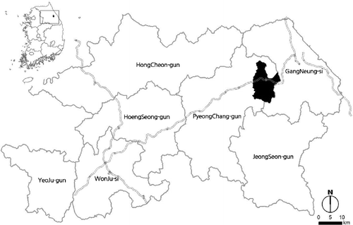
The Alpensia district in Pyeongchang is the core area of the Pyeongchang Winter Olympics zone and is adjacent to the Baekdudaegan protection zone; thus, it was selected as a critical area in regards to forest landscape management. The games that are to be held in this area during the Pyeongchang Winter Olympics are alpine skiing (giant slalom, slalom), cross-country skiing, Nordic skiing, and the ski jump, biathlon, luge, skeleton, and bobsled. The study area is 125.84 km2 ().
Figure 1. Study area. The Winter Olympic area is shaded in black.
Analysis methodology
Lee and Park (Citation2012) presented a methodology for the classification of landscape management areas of a forested region. Lee et al. (Citation2013) developed forest landscape management division methods in which they divided the High One Resort forest into zones and assigned each zone a management grade. Lee et al. (Citation2008, Citation2009, Citation2010, Citation2011) contributed to the preparation of the “Forest Landscape Plan and Management Business Guide” by the Korea Forest Service (Citation2011) through a preliminary study and application of the process. The current study adjusts and complements the methodology of this prior study so that it is applicable for the Alpensia district.
Viewpoint selection and the landscape slide acquisition method
Viewpoint setting was performed in accordance with the standards of previous studies. Viewpoints were set primarily at points where the forest is easily viewed from the surroundings (e.g., the first point from where Alpensia stadium can be seen, outstanding forest landscape resource, the entrance into the Olympics zone, the entrance into the stadium, high-use areas such as the lodge or stadium, and the major nodes connecting high-use and transportation areas), points from where surroundings can be easily viewed from inside the stadium (a major object of landscape management, including a major ridge and mountain top, observation facility point, and ropeway stadium), and the viewpoint from inside the forest (a point from where the Alpensia game stadium, an excellent forest resource, is easily viewed). One hundred and twenty preliminary viewpoints were selected on the satellite image and aerial photograph according to the viewpoint selection criterion, and 61 viewpoints were selected finally through site visits. Sixty-one total viewpoints were selected at places of high-use, including in the Olympics zone, at the entrance area into the stadium and lodges, points from where the forest is easily viewed from inside the stadium, and the ropeway stadium (; ). A total of two field surveys were realized on 25–26 and 31 July 2013.
Figure 2. Selection result of viewpoints.
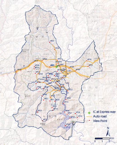
Table 1. Results of viewpoints coordinates.
Analysis of visual sensitivity and the level of landscape management required
Incorporating the methods of the United States (USDA Forest Service Citation1993), Australia (FCT Citation2006), and Canada (British Columbia Citation1981), a method presented by Lee and Park (Citation2012) and Lee et al. (Citation2013), and GIS data obtained for the study area, methods for visual sensitivity and the level of landscape management required were developed.
The standards were set such that having a higher altitude, steeper slope, greater crown density, more simple vegetation structure or being further south or further from a road, building, golf course, ropeway, or other facility confers a greater visual sensitivity to landscape ().
Table 2. Standard of analysis for visual sensitivity.
The landscape management requirement is to classify how much landscape management is required, and select and intensively manage the landscape depending on the degree of requiring the landscape management, and is being analyzed also by the Korea Forest Service to determine the strength of landscape management (USDA Forest Service Citation1973, Citation1974; British Columbia Citation1981, Citation1996; FCT Citation2006; Lee et al. Citation2008, Citation2009, Citation2010; Korea Forest Service Citation2011).
For the level of landscape management required, the relationship of distance between relevant points was classified into high, middle, and low by the quantile method, based on the distances from viewpoints to road-crossing points around major roads, rivers, lakes, hills, and village forests, and the village and lodge. Shorter distances were assigned higher scores ().
Table 3. Standard of analysis for landscape management requirement.
Landscape management grade setting and division
The landscape management grade was determined by overlapping the landscape management requirement level and visual sensitivity analysis results (, ). For instance, the zone where visual sensitivity is “high”, and landscape management requirement level is “low” can be classified as landscape management grade 1 and zoned as having a high conservation value. Analyses were performed with Korea Forest Service FGIS, ArcGIS ver. 9.3, AutoCAD 2013, and Excel 2013.
Table 4. Forest landscape management grade determination matrix.
Table 5. Setting of the management direction for forest landscape management grade.
Results and discussion
State analysis for study area and landscape resource
It was found that Yeongdong expressway crosses through the center of the entire study area east to west, which is primarily accessed via Hoenggye IC (Interchange). Nearly 67% of the study area was at 800 m or higher above sea level, and approximately 2% of the area was at 1200 m or higher. The highest mountain in the area is Mt. Balwang (1428 m), which is used as a ski slope at the Yongpyeong resort. Likewise, it will be used as the alpine ski stadium for the 2018 Pyeongchang Winter Olympics. The central area of Daegwanryeong-myeon and the lodge facility at the resort were located below 800 m. Vegetation inside the study area was primarily broad-leaved tree mixed forest (28.47%) and conifer and broad-leaved tree mixed forest (21.09%), covering the greatest area of Mt. Balwang and Mt. Hwangbyeong. In other areas, larch (Pinus densiflora) and grassland were widely distributed.
Results of visual sensitivity analysis
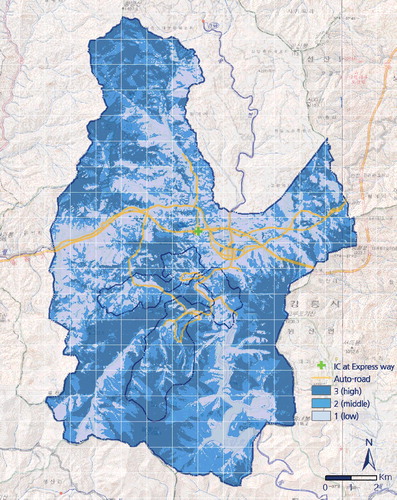
Visual sensitivity was “high” across the entire top of Mt. Balwang (the alpine ski stadium site), Mt. Hwangbyeong in the north, and Mt. Gorupogi in the east (). The areas of “middle” sensitivity were most notable in the areas surrounding Lake Doam and were equally and fragmentarily distributed in other areas. The area of Yeongdong expressway's horizontal and vertical axis near downtown Daegwanryeong-myeon was determined to have “low” landscape change sensitivity; thus, it was concluded that active forest landscape management is needed here. Sensitivity was low around the entrance area, high-use ropeway, and passage frequency inside the stadium area.
Figure 3. Analysis result of visual sensitivity.
Results of the landscape management requirement level analysis
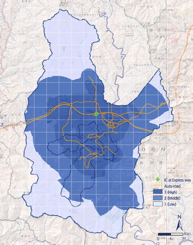
Areas with a “high” level of landscape management requirement were main roads and cross roads, major farmland areas, and residential and commercial areas. The areas requiring a “middle” level of landscape management is included some villages and farmland in middle mountainous areas. The areas requiring a “low” level of landscape management requirement level were other areas with little traffic, relatively far away, and in their natural state ().
Figure 4. Analysis result of landscape management requirement.
Division of landscape management grade
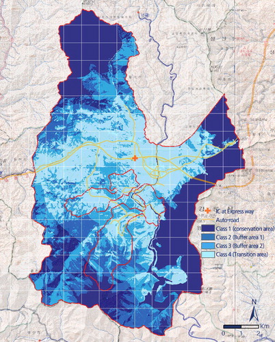
According to the grade assignment results obtained by combining the results of the visual sensitivity and landscape management needs analyses (), grade 1 was primarily assigned to the high areas of Mt. Balwang and Mt. Hwangbyeong in zone division. Grades 2 and 3 were principally in the medium mountainous areas. Downtown Daegwanryeong-myeon, all roads, the land in Alpensia, and the lodge facilities area were classified as grade 4. However, because this area is a protected area due to the rare biota found there, it should necessarily be preserved regardless of grade; thus, it was set as a grade 1 conservation area.
Figure 5. Result of division of landscape management grade.
Conclusions
This study was performed to assign landscape management grades to the entire Alpensia area, divide space into areas of similar grade, and provide fundamental data needed for decision-making for landscape management decisions. After selecting viewpoints through satellite images, aerial photographs, and on-site inspection and subsequent analysis of the study area's natural and cultural resources, visual sensitivity and level of landscape management requirement were performed. Grades for landscape management were determined, and zone classification was performed through arithmetic operations by overlaying visual sensitivity and level of landscape management requirement. The results and implications are as follows:
In viewpoint selection, a total of 61 viewpoints were selected including areas with high-use such as the entrance to the Alpensia stadium, lodges, major ridges, and mountain tops.
Visual sensitivity analysis showed that the entire top of Mt. Balwang's, Mt. Hwangbyeong, and Mt. Gorupogi, which are to be used as the alpine ski stadium were areas of “high” visual sensitivity. Visual sensitivity in the area of the horizontal axis of Yeongdong expressway, downtown Daegwanryeong-myeon, and the resort facilities was “low.”
The analysis of landscape management requirement level determined areas with major roads, cross roads, farmland, and residential and commercial areas was “high,” and areas with relatively little traffic maintained in a primarily natural state was “low.”
By overlapping the results of forest landscape management grade derivation (determined through arithmetic operation) with the landscape management requirement level, the region was divided into zones including four total grades. It was shown that areas with many major mountain tops were of grade 1 and downtown Daegwanryeong-myeon and the entire area of the Alpensia resort were of grade 4.
It is concluded that this study provides the baseline data needed to inform decision-making for directing forest management from a macroscopic viewpoint. Additionally, forest landscape management will be necessary and consistent with area features that are part of the forest landscape of each zone in the future.
Additional information
Funding
References
- British Columbia. 1981. Forest landscape handbook.
- British Columbia. 1996. Clear cutting and visual quality: a public perception study.
- Forestry Commission of Tasmania (FCT). 2006. A manual for forest landscape management.
- Gangwon. 2013. 2018 PyeongChang Winter Olympic Zone Master Plan (draft) –view reports for residents (the second). Gangwon Internal reports.
- International Olympic Committee (IOC). 2011. 2018 HOST CITY ELECTION 3 candidate cities: Munich, Annecy, PyeongChang. http://www.olympic.org/2018-host-city-election?tab=2018-election
- Korea Forest Service. 2011. Manual of forest landscape management plan.
- Lee GG, Jang HJ, Lee MJ, Jo HK. 2013. A study on setting up method for visual management of forest landscape and field application –focused on forest landscape around High One Resort in Jeongseon-gun, Gangwon-do. J Environ Impact Asses. 22(1):65–78.
- Lee GG, Lee JH, Jang HJ. 2009. Research officer national forest inventories. First year reports, Korea Forest Research Institute.
- Lee GG, Lee JH, Jang HJ. 2010. Research officer national forest inventories. Second year reports, Korea Forest Research Institute.
- Lee GG, Lee JH, Jang HJ. 2010. Research officer national forest inventories. Third year reports, Korea Forest Research Institute.
- Lee GG, Park CW. 2012. A zoning method for forest landscape management by visual quality assessment. J Kor Forest Soc. 101(1):148–157.
- Lee GG. 2008. Study on forest landscape belt building. Korea Forest Service reports
- USDA Forest Service. 1973. National Forest landscape management. Volume 1.
- USDA Forest Service. 1974. National Forest landscape management. Volume 2.
- USDA Forest Service. 1993. Landscape aesthetics: a handbook for scenery.