
Abstract
An efficient forest road network can increase accessibility to entire forest lands and decrease construction and maintenance costs. In this study, first cost layer for road construction in the semi-mountainous Hyrcanian forest was developed by overlaying thematic layers of slope steepness, soil depth, and proximity to hydrograph network in geographical information system (GIS). Analytical network process (ANP) was used to determine the importance of the layers. Nine road network alternatives were designed on cost layer using PEGGER and then the efficiency of each alternative was evaluated according to the metric of road passage percentage from cost classes. Technical assessment was done by analyzing metrics of overlaps, opened area, and corrected ton-km. The optimum forest road network alternative was selected by pairwise comparison of alternatives with respect to metrics. Based on our findings, we strongly recommend the use of alternative 8 whenever possible, because the construction cost, corrected ton-km, and overlaps were lower, and the opened area was higher than those of the other alternatives.
Introduction
Forest roads are important elements in forestry plans. They are used mainly for forest harvesting operations, tourism, and forest conservation (Najafi et al. Citation2008). Forest roads are often unpaved and carry traffic between harvesting areas and paved public roads (Olsson and Lohmander Citation2005). Forest road network design is the most expensive and time consuming part of a harvest operation plan (Tan Citation2000; Ghajar et al. Citation2013). The existence of forest roads in productive forests is necessary, although the appropriate length and optimum location of these roads is open to debate (Eastaugh and Molina Citation2011). This study attempts to apply designer extension in geographical information system (GIS) and network analysis techniques to assess different road network alternatives (Hosseini et al. Citation2012). This is significant because it can help forest engineers select optimum road alternatives (Parsakhoo et al. Citation2008). Proper planning of road networks is key to maintaining the pavement quality of forest roads and surrounding ecosystems (Taiwo and Kumi Citation2013), because traffic numbers can be distributed normally on roads.
Forest roads should be planned in agreement with land stability as an indicator of construction and maintenance costs (Dean Citation1997). Some researchers have applied GIS techniques to provide cost layers for designing forest road networks (Demir Citation2007). The use of these techniques in construction projects can result in time and cost savings, and can minimize environmental damage (Ghaffarian and Sobhani Citation2007). Abdi et al. (Citation2009) used GIS and analytical hierarchy process (AHP) to design a forest road network with the lowest construction cost. Six road alternatives were designed using a road-pegging tool (PEGGER) on integrated map from soil, slope, aspect, stock volume, and etc factors (Najafi et al. Citation2008). AHP was then used to evaluate the construction cost of the alternatives (Babapour et al. Citation2015). Babapour et al. (Citation2006) applied GIS and PEGGER to produce a stability map and plan a new road network, respectively. TRACER, inROAD and router are the other extensions used to design road networks (Demir and Ozturk Citation2004). Jaafari et al. (Citation2015) produced a landslide susceptibility map of a northern forest in Iran to design road network alternatives using PEGGER in ArcView GIS extension. Then the alternatives were evaluated on the basis of cost (Akay and Sessions Citation2005).
Different methods have been used to assess a road network from both technical and cost points of view (Pentek et al. Citation2005). Shortest path algorithm, Backmund method, decision trees algorithm, and ton-km are the main approaches in assessing a forest road network (Anderson and Nelson Citation2004). Backmund algorithm determines the degree of forest openness through buffering forest roads. The opened area in the forest has to be calculated from determining skidding distance and accessibility limits. The size of opened areas is an indicator of forest road network efficiency. Overlaps are created when buffers of two or more roads come into contact. These areas are opened twice so overlapping is unsuitable for forest openness. Hosseini et al. (Citation2012) planned road network alternatives on a stability map and then analyzed each alternative using the ton-km method (Aydinel et al. Citation2008). Ton-km is a unit of transportation system which describes the payload and traffic on a forest road network (Quijada-Alarcon et al. Citation2012). Ton-km measures timber load on a given road by the average length of the trips in kilometers (Amato et al. Citation2013). In the corrected ton-km method, which was used in the current study, the correction factor of skidding distance and conversion factor of tree volume to weight were added to equation. Among road network alternatives with the same density, a network with lower ton-km is the best, because the loads are normally dispersed on other branches of the network and so less pressure is exerted on the road pavement (Galatioto et al. Citation2015). On roads with the same bearing ratio and pavement aggregate size, an increase in traffic and payload causes reduced dust emissions from the road surface and increases pavement deformation (Grigolato et al. Citation2013).
Efficient transportation systems are necessary to develop and facilitate economic growth of forestry plans (Olsson Citation2007). Improved road network design can decrease construction and maintenance costs as well as reduce forest damage (Soltani et al. Citation2013). The novelty of this work is combining the designing, evaluation, and decision making systems in a model. The objectives of this study were to develop cost layer for road construction in the study area and propose several forest road network alternatives with a view to identifying an optimum network by considering economic (construction cost) and technical parameters (network opened area, overlaps area, and corrected ton-km).
Materials and methods
Description of the study area
Bahramnia forest is located in Golestan province and in watershed number 85. This forest has been divided into two districts. District 1, with an area of 1713.3 ha, extends from 36˚43´27˝–36˚45´6˝ N and 54˚21´26˝–54˚24´57˝ E. District 2, with an area of 1992 ha, extends from 36˚42´30˝–36˚43´30˝ N and 54˚21´6˝–54˚23´30˝ E. The total length of the studied forest roads was 31,059 m in district 1 (with network density 18.13 m ha−1) and 30,214 m in district 2. Four hundred hectares of these forests is protected, so a total 3305.3 ha of forest should be opened by 61,273 m of roads. The road density in Bahramnia forest is 18.54 m ha−1. The bedrock is limestone and sandstone, with altitude ranging from 100 to 1935 m above sea level. The forest is mixed deciduous which has been established on brown forest soil with mostly sandstone as bedrock, clay-loam-silty soil, and worn stones are spread around the area. The climate is moderate and moist, with mean annual precipitation ranging from 528 to 817 mm.
Cost layer preparation
Slope steepness, soil depth, and proximity to hydrograph network were the parameters used in preparing the cost layer for forest road construction in our study area. The slope layer was produced from the digital elevation model (DEM) using the surface analysis command in ArcMap. DEM was produced from contour lines (National Cartographic Center). The classification of slope was conducted according to correction factor (K) of skidding distance presented by Lotfalian and Parsakhoo (Citation2012) for northern forests in Iran. The classification of slope was conducted according to restrictions for skid trail planning. In Iranian forestry protocol, slope class 0%–20% is low and skidders can move in all directions. In class 20%–50% skidders can move along the slope and/or diagonally on skid trails. A slope class of more than 50% is very steep and is not suitable for ground-based skidding systems ().
Figure 1. (a) Slope layer, (b) soil layer, (c) hydrograph layer of the study area.
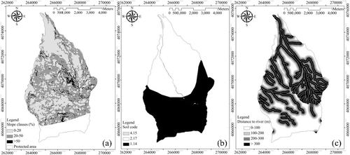
The soil map was prepared in geology organization and classified into categories land code 1.14 (includes high mountainous forest with deep valley. The bedrock is limestone, sandstone, shale, and schist as well as metamorphic igneous rock. The soil has low depth and heavy texture, land code 2.17 (includes low high mountainous forest with flat crest. The bedrock is conglomerate and sand stone as well as loess formations. The soil depth is moderate to deep and soil texture is heavy) and land code 4.15 (includes low hillside plains with flat alluvial of stream. The soil is deep with clay and loam-clay texture and the alluvial part is clay-sandy-loam (b). Euclidean distance of 0–100, 100–200, 200–300 and more than 300 m were considered around the river network to prepare the hydrograph multi-buffer layer. Roads that are close to rivers have potential of sediment delivery and landslide. ArcMap was used to create buffer zones along the river (c).
The selected layers were integrated using the overlay process in GIS and a road construction cost layer was produced. The analytic network process (ANP) was applied by asking 10 forest engineering experts to determine the relative weight for each criterion (). Each questionnaire contained questions about the importance of each factor influencing road construction cost. The eigenvector of each criterion in super matrix was calculated in super decision software (Saaty Citation2008).
Table 1. Weights and ratings assigned to criteria and classes for cost layer modeling by ANP.
Designing road network alternatives
Nine road network alternatives were designed on cost layer by PEGGER extension in ArcView. The road routes should fit into the terrain and topography conditions. PEGGER is an automated contour-based route projection for forest road designs. In this system, divider width (d) should be calculated by:(1)
where, ∆E is contour line intervals in meter and g is slope of road segment in percent.
Road network assessment by cost analysis
Cost layer of the study area was categorized into three classes with high, moderate, and low cost for forest road construction. Then, the percent of road passage from each class was recorded to establish network alternatives.
Road network assessment by opened area and overlap analysis
Buffers with a width of approximately 270 m as maximum skidding distance of the study area were designed at both sides of the road network for each alternative. This buffer is called forest opened area by road. On opened area overlap sections were identified in ArcMap software with a command of intersects and then the areas were measured. The following equation was used to calculate maximum skidding distance (T):(2)
where, T is maximum skidding distance in meter and RD is road network density in m ha−1.
Road network assessment by corrected ton-km
The geometrical centers of compartments were determined using data management tools in GIS and then the perpendicular distance of these centers to roads was measured as theoretical skidding distance (D). The stock growth map was produced according to mean volume of trees per hectare in each compartment. Then, Equationthe(3) following equation was used to measure the load of timber passing over each kilometer of road:
(3)
where, Y is the mean of ton-km of network, V is stock growth of compartment in m3 ha−1, D is skidding distance in km, K is correction factor of skidding distance, M is conversion factor of volume to weight (0.7 for broadleaved species) and n is the number of compartments. In this study, the correction factor K of 2, 3, and 4 has been applied for skidding distances over hillside slopes of 0%–20%, 20%–50%, and > 50%, respectively (Lotfalian and Parsakhoo Citation2012).
Optimization of forest road network
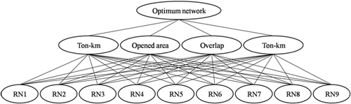
The optimal road network based on the least construction cost, overlap, and ton-km was identified using ANP in super decision software. The hierarchy tree of this process is given in
Figure 2. Hierarchy used to select the optimal forest road network.
Results
Road network passage from cost classes
The road cost zonation map was classified into three construction cost categories: high (12.3% of the area); moderate (46.2% of the area); and low (41.5% of the area) (). The physiographical properties of these classes are shown in . Classes with low cost for road construction include those areas furthest from the river, and with a gentle slope and stable soil. The density of designed alternatives on cost layer was 18 to 20 m ha−1. Alternative 1 is the existing and proposed forest road network in the region. Since the designed alternatives pass through gentle terrain they have low to moderate construction cost and are almost all located in the same areas (). Approximately 60% of road alternatives 2 and 3 pass through the area with low construction cost. More than 9% by length of road network alternatives 4 and 7 pass over unstable ground and so have high construction costs ().
Figure 3. Road network alternatives on cost layer of study area.
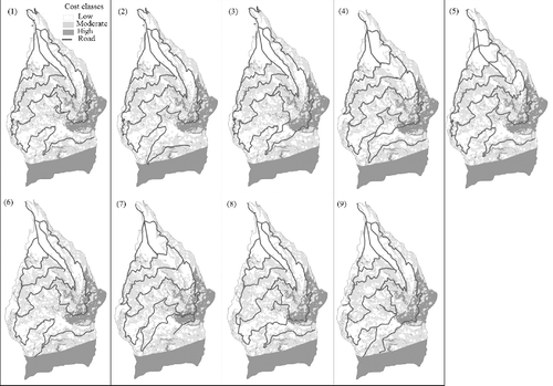
Table 2. Physiographical properties of cost classes.
Table 3. Passage of road network alternatives from different classes of cost layer.
Opened areas by road network and overlaps
shows the road network alternatives with buffers around roads equal to maximum skidding distances, as well as overlaps. The degree of forest openness in alternative 8 was more than that of the other alternatives. Minimum overlaps were found for alternative 6. Inaccessible areas or gaps for ground-based skidding systems were lowest for alternative 8 ().
Figure 4. Opened areas and overlaps of road network alternatives.
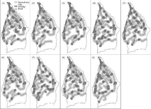
Table 4. Forest openness and overlaps caused by various alternatives of the road network.
Road network status according to corrected ton-km
Road network alternatives with specific density were distributed with various patterns on forest land. This planning is done according to the forest stock growth capability map () and shortest skidding distances from the geometrical center of compartments to road. The forest road network should allow easy and quick access to the center of compartments from two directions. The forest road should be perpendicular to the expected direction of the geometrical center of compartments (). Using the ton-km algorithm for each compartment, depending on the shortest wood skidding distance, stock growth, and correction factors, we can calculate the unit traffic pressure in tons per kilometer. Minimum ton-km was recorded for alternative 5 ().
Figure 5. Forest stock growth capability map.
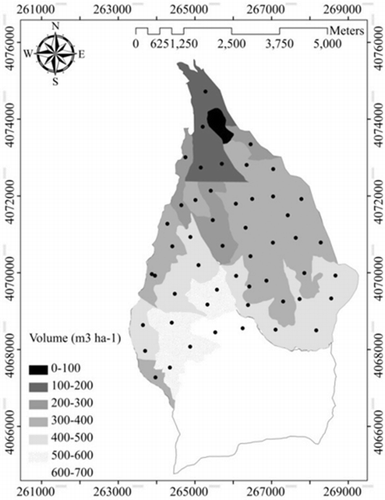
Figure 6. Road network alternatives according to corrected ton-km.
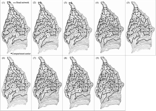
Table 5. Ton-km values for alternatives.
Optimization of forest road network
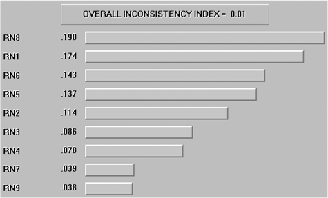
Results showed that criteria affecting prioritization of road network alternatives were cost, ton-km, overlaps, and opened area, with relative weights of 0.100, 0.225, 0.297 and 0.377. The priorities of the various road network alternatives with respect to cost, ton-km, overlaps, and opened area criteria found that alternatives 3, 5, 6, and 8 were the best, respectively (). Overall priority of road network alternatives revealed that alternative 8 was the optimum option ().
Table 6. Weights of criteria and ratings assigned to forest road network (RN) alternatives.
Figure 7. Overall priority of road network alternatives.
Discussion
In this study we produced cost layer as road designing dataset by overlaying slope, soil, and hydrograph layers. This experience will be very useful in future case studies. The cost layer presents the conditions in which forest road design and construction is environmentally friendly and cost effective. In the next step we designed nine forest road network alternatives using PEGGER. PEGGER is a judicious and appropriate tool for forest engineers as it can enable the designer to develop a far superior harvest plan. This design work was also carried out according to optimal distribution of roads among geometrical centers of compartments. This approach had been previously used by Košir and Krč (Citation2000). They applied multi-criteria decision making to prepare a suitability map of terrain for the design and construction of forest roads and skidding tracks.
Our findings show that approximately 60% of road alternatives 2 and 3 passed through the area with low construction cost, which was more than that of other alternatives. Heralt (Citation2002) reported that road network design depends not only on costs, but also on other factors such as local distribution of roads. Local distribution can be assessed by measuring opened areas and overlaps and by the perpendicular distances of geometrical centers of compartment to road (Jourgholami et al. Citation2013). Road network alternatives of this study were evaluated based on ton-km, overlap, and cost layers to locate a final route that meets operational and environmental targets.
Opened area by road network includes consideration of both road lengths and skidding distances. Maximum forest openness was recorded for road alternatives 1 and 8 with the same density of 18.54 m ha−1. Overlap area is created in the region where two buffers of roads come together. Indeed, these areas are opened twice and decrease road efficiency (Pentek et al. Citation2005). Yongtaek and Hyunmyung (Citation2005) reported that a merit of proposed road alternative is to provide efficient network under consideration of overlaps among roads to alleviate the road similarity. Enache et al. (Citation2013) used decision support tools to evaluate different forest road alternatives. The main steps of their study were locating new roads, assessment of productivity and cost of timber extraction, evaluation of environmental impact, and utility analysis. The forest road alternative with the highest utility was selected as the most suitable option (Żak and Węgliński Citation2014).
Pentek et al. (Citation2005) determined the mean skidding distance by use of the center of gravity method on maps. They represented the geometrical mean skidding distance has to be corrected by a correction factor of wood skidding. This approach was in agreement with our research method. We used correction factor of skidding distance and conversion factor of trees volume to weight to improve the traditional ton-km equation. According to our findings, the minimum ton-km was recorded for alternative 5. This, and other alternatives, are approximately similar in density, but alternative 5, with the lowest ton-km, dispersed the travel loads onto other branches of the network and so lowered the pressure transmitted to the road pavement (Galatioto et al. Citation2015).
As a result, basically the main criteria effecting prioritization of road network alternatives were cost, ton-km, overlaps, and opened area, with relative weights of 0.100, 0.225, 0.297 and 0.377. The priorities of the various road network alternatives with respect to cost, ton-km, overlaps, and the opened area criteria found that alternatives 3, 5, 6, and 8 were the best, respectively. These sets of priorities often present tradeoffs that make the decision process even more complex. Four alternatives of the forest road network were designed by Stefanović et al. (Citation2015) in fire-prone environment. Alternatives were analyzed against seven criteria, and the best alternative was selected using entropy weight coefficients (EWC). They showed that the greatest importance was given to the criteria relating to the cost of construction. Many models are available for multi-criteria analysis of forest roads (Coulter et al. Citation2006). ANP has the potential to provide a consistent approach to the ranking of forest road alternatives based on four criteria: cost; ton-km; overlaps; and opened area. Overall priority of road network alternatives revealed that alternative 8 was the optimum option ().
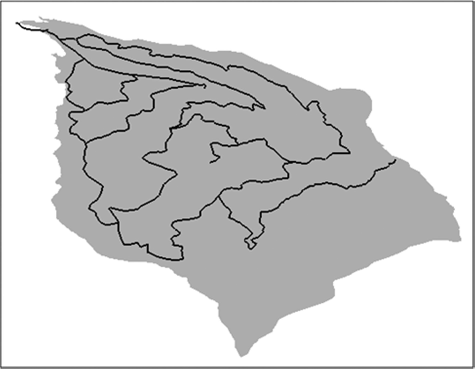
Figure 8. Optimum alternative 8.
Conclusions
This article presents the application of the automated GIS-based road-pegging tool (PEGGER) for planning and designing forest road alternatives. Nine alternatives of the road network were generated for a single tree selection cutting forest and then were evaluated by cost, ton-km, overlaps, and opened area analysis. The proposed methodology can be applied by forest planners and forest engineers in strategic planning of forest transportation systems. The major advantages of this methodology are evaluation of the current status/existing forest road network and proposed alternatives, and then selection of the most appropriate alternative by a multiple criteria decision making system.
With single criteria decision making, alternative 3 is the lowest cost network for construction, alternative 5 provides the lowest ton-km of service, alternative 6 has the lowest overlaps, and alternative 8 has the highest openness capacity, but after multiple criteria decision making by ANP the overall preferences of the road network showed that alternative 8 was the best solution for the forest transportation system in our study area.
Acknowledgements
Thanks to the staff and local harvesting team of Shast Kalate forests for their help in transportation and data collection in the experimental areas.
Disclosure statement
No potential conflict of interest was reported by the author.
References
- Aydinel M, Sowlati T, Cerda X, Cope E, Gerschman M. 2008. Optimization of production allocation and transportation of customer orders for a leading forest products company. Math Comput Model. 48:1158–1169.
- Akay AE, Sessions J. 2005. Applying the decision support system, TRACER, to forest road design. Western J Appl Forestry. 20:184–191.
- Amato F, Pandolfi M, Alastuey A, Lozano A, Contreras González J, Querol X. 2013. Impact of traffic intensity and pavement aggregate size on road dust particles loading. Atmos Environ. 77:711–717.
- Abdi E, Majnounian B, Darvishsefat A, Mashayekhi Z, Sessions J. 2009. A GIS-MCE based model for forest road planning. J For Sci. 55:171–176.
- Anderson AE, Nelson J. 2004. Projecting vector based road networks with shortest path algorithm. Canadian J For Res. 34:1444–1457.
- Babapour R, Naghdi R, Salehi A. 2006. The importance of GIS in forest roads planning (case study, Shafarood catchment). GIS conference, ITC Scientific Society. 1:663–668.
- Babapour R, Naghdi R, Ghajar I, Ghodsi R. 2015. Modeling the proportion of cut slopes rock on forest roads using artificial neural network and ordinal linear regression. Environ Monitor Assess. 187:446–460.
- Coulter ED, Coakley J, Sessions J. 2006. The analytic hierarchy process: a tutorial for use in prioritizing forest road investments to minimize environmental effects. Int J For Eng. 17:51–69.
- Dean JD. 1997. Finding optimal routes for networks of harvest diet access roads using GIS-based techniques. Canadian J For Res. 27:11–22.
- Demir M, Ozturk T. 2004. A research on forest road planning and projecting by inroads software in Bolu region of Turkey. American J Appl Sci. 1:295–301.
- Demir M. 2007. Impacts, management and functional planning criterion of forest road network system in Turkey. Transp Res Part A: Policy Pract. 41:56–68.
- Eastaugh CS, Molina D. 2011. Forest road networks: metrics for coverage, efficiency and convenience. Australian For. 74:54–61.
- Enache A, Kühmaier M, Stampfer K, Ciobanu V. 2013. An integrative decision support tool for assessing forest road options in a mountainous region in Romania. Croatian J For Eng. 34:43–60.
- Grigolato S, Pellegrini M, Cavalli R. 2013. Temporal analysis of the traffic loads on forest road networks. iForest 6:255–261.
- Galatioto F, Huang Y, Parry T, Bird R, Bell M. 2015. Traffic modeling in system boundary expansion of road pavement life cycle assessment. Transp Res Part D: Transp and Environ. 36:65–75.
- Ghaffarian MR, Sobhani H. 2007. Optimization of an existing forest road network using Network 2000. Croatian J For Eng. 28:185–193.
- Ghajar I, Najafi A, Karimimajd AM, Boston K, Torabi SA. 2013. A program for cost estimation of forest road construction using engineer's method. For Sci Tech. 9:111–117.
- Heralt L. 2002. Using the road system to design an optimum forest road variant aimed at the minimization of negative impacts on the natural environment. J For Sci. 48:361–365.
- Hosseini S, Khalili M, Pourmajidian M, Fallah A, Parsakhoo A. 2012. Relationship between forest road length and village development during three decades. J For Sci. 58:1–7.
- Hosseini SA, Mazrae MR, Lotfalian M, Parsakhoo A. 2012. Designing an optimal forest road network by consideration of environmental impacts in GIS. J Environ Eng Landscape Manage. 20:58–66.
- Jaafari A, Najafi A, Rezaeian J, Sattarian A, Ghajar I. 2015. Planning road networks in landslide-prone areas: a case study from the northern forests of Iran. Land Use Policy. 47:198–208.
- Jourgholami M, Abdi E, Chung W. 2013. Decision making in forest road planning considering both skidding and road costs: a case study in the Hyrcanian Forest in Iran. iForest 6:59–64.
- Košir B, Krč J. 2000. Where to place and build forest roads-experience from the model. J For Eng. 11:7–19.
- Lotfalian M, Parsakhoo A. 2012. Forest roads network planning. Tehran: Ayiizh Press.
- Najafi A, Sobhani H, Saeed A, Makhdum M, Mohajer MM. 2008. Planning and assessment of alternative forest road and skidding networks. Croatian J For Eng. 29:63–73.
- Olsson L, Lohmander P. 2005. Optimal forest transportation with respect to road investments. For Policy Econ. 7:369–379.
- Olsson L. 2007. Optimal upgrading of forest road networks: Scenario analysis vs. stochastic modeling. For Policy Econ. 9:1071–1078.
- Parsakhoo A, Hosseini SA, Lotfalian M, Jalilvand H. 2008. Bulldozer and hydraulic excavator traffic effect on soil bulk density, rolling project and tree root response. Int J Natural Eng Sci. 2:139–142.
- Pentek T, Pičman D, Potočnik I, Dvorščak P, Nevečerel H. 2005. Analysis of an existing forest road network. Croatian J For Eng. 26:39–50.
- Quijada-Alarcon J, Cancelas NG, Orive AC, Flores FS. 2012. Road network analysis using decision trees algorithm: a case of study of Panama. Adv Res Sci Areas. 7:1876–1880.
- Saaty TL. 2008. The analytic hierarchy and analytic network measurement processes: applications to decisions under risk. European J Pure Applied Math. 1:122–196.
- Soltani A, Zargari Marandi E, Esmaili Ivaki Y. 2013. Bus route evaluation using a two-stage hybrid model of Fuzzy AHP and TOPSIS. J Transp Lit. 7:34–58.
- Stefanović B, Stojnić D, Danilović M. 2015. Multi-criteria forest road network planning in fire-prone environment: a case study in Serbia. J Environ Plan Manage. 24:1–16.
- Taiwo A, Kumi F. 2013. An appraisal of road condition effect on rural transportation in Sekyere central district of the Ashanti Region of Ghana. J Transp Tech. 3:266–271.
- Tan J. 2000. Application of dynamic programming to optimum location of a forest road. J For Eng. 11:33–42.
- Yongtaek L, Hyunmyung K. 2005. A shortest path algorithm for real road network based on path overlap. J Eastern Asia Soc Transp Stu. 6:1426–1438.
- Żak J, Węgliński S. 2014. The selection of the logistics center location based on MCDM/A methodology. Transp Res Procedia. 3:555–564.