
 ?Mathematical formulae have been encoded as MathML and are displayed in this HTML version using MathJax in order to improve their display. Uncheck the box to turn MathJax off. This feature requires Javascript. Click on a formula to zoom.
ABSTRACT
Since the 2008 financial crisis, international investments in farmland have attracted considerable academic attention, yet surprisingly little is still known about their subnational determinants. To uncover why foreign land deals are situated in a particular territory, I incorporate this empirical puzzle with arguments about African state dynamics in processes of large-scale land acquisitions (LSLAs). This article argues that African authorities use LSLAs as strategies of extraversion: ruling elites sell or lease large parcels of land in areas with weak state infrastructural capacity. By doing so, they assert their formal authority by granting formal land titles, while concurrently outsourcing their responsibility for public good provision to foreign investors. I empirically test my argument using recently improved satellite imagery and the subnational locations of 468 land deals in Sub-Saharan Africa between 2008 and 2018. Innovative spatio-temporal models are estimated, allowing for insightful contributions to current research on farmland investments, African statehood and research methods. Results confirm my theoretical expectations: night-time light emission, as a measure of subnational infrastructural capacity, is negatively associated with new LSLAs. In other words, LSLAs are located in areas with poor infrastructural capacity, so that African states can benefit from them to maintain themselves.
1. INTRODUCTION
African land has been of interest to foreign investors repeatedly since the colonial period (Wily, Citation2013). However, with the 2008 global financial crisis, there has been a rapid and sharp increase in large-scale land acquisitions (LSLAs): a ‘global land rush’ (Borras et al., Citation2011; Sassen, Citation2013). Since then, at least 200,128 km2 of land have been contracted to foreign investors in Sub-Saharan Africa (SSA) – an area larger than Senegal – out of which only 22,625 km2 are estimated to be under production (Land Matrix Initiative, Citation2022; author’s own calculations).Footnote1 This paper specifically investigates acquisitions of Sub-Saharan land for purposes of agricultural production, conservation, timber exploitation and renewable energies that have been ongoing since 2008. These LSLAs are denounced as ‘land grabs’ if they exhibit characteristics such as: violation of human rights; lack of free, prior and informed consent of the affected land-users; disregard for socio-economic and environmental impacts; lack of transparency; and absence of democratic planning, independent oversight and meaningful participation (International Land Coalition, Citation2011, p. 2; see also De Schutter, Citation2011). Their discriminatory character has been confirmed by numerous studies that find predominantly negative consequences (for recent findings, see Chiarelli et al., Citation2022; Dell’Angelo et al., Citation2021; Mechiche-Alami et al., Citation2021). Considering the prevalent role that capitalist entities play in this global process, and the brutal sorting of ‘winners’ and ‘losers’, these investments are studied as instances of ‘primitive accumulation’ (Ince, Citation2014), ‘accumulation by dispossession’ (Hall, Citation2013; Harvey, Citation2004), ‘commons enclosure’ (De Angelis, Citation2007), or ‘commons-grabbing’ (Dell’Angelo et al., Citation2017).
With all the valuable contributions made to improve our understanding of this phenomenon, which has local, national and global ramifications, we surprisingly still know little about the subnational determinants of LSLAs – or, to put it differently, why are they situated where they are? Concurrently to this interrogation, scholars have been arguing that host governments are active ‘calculating partners’ in LSLAs (Wolford et al., Citation2013, p. 192), that state dynamics somehow play into farmland investments (Schoneveld, Citation2017), and a few case studies have found evidences of state consolidation through LSLAs (for Senegal, see Benegiamo, Citation2020; for Uganda, see Carmody & Taylor, Citation2016; and for Ethiopia, see Lavers & Boamah, Citation2016).
This paper links the latter strand of arguments to the former interrogation and exposes the subnational political determinants of LSLAs. I propose the argument that LSLAs have to be understood as strategies of extraversion (Bayart & Ellis, Citation2000). To build and strengthen themselves, African states use their relations of dependence and further their own interests by engaging with actors that are seemingly weakening them, such as foreign corporate entities. In the case of LSLAs, I hypothesize that African ruling elites instrumentalize them to compensate for weak local state infrastructural capacity, that is their states’ uneven ability to penetrate their territories and implement their decisions (Mann, Citation1984, p. 189). By granting European-style land titles for LSLAs, ruling elites assert their formal authority, and they simultaneously ‘dump’ (Mbembé, Citation2000, p. 159) states’ traditional functions of public good provision to foreign investors. For this extraversion strategy to be successful, LSLAs have to be located in territories where the state has a relatively weak infrastructural capacity.
My argument is empirically tested using satellite imagery and the subnational locations of 468 LSLAs in 32 countries of SSA, between 2008 and 2018. To adequately represent the phenomenon, state infrastructural capacity is measured using newly calibrated night-time light emission (Chen et al., Citation2021; Koren & Sarbahi, Citation2018), and innovative spatio-temporal models are estimated. Overall, the results support my theoretical expectations: models show that stronger capacity deters foreign farmland investments. This finding shows how African ruling elites use LSLA emplacement to attempt to consolidate the state as one of their sources of power. The kind of state power built through processes of LSLAs is however distinct of the neoliberal era, where the national territory is ‘denationalized’ through its endogenization in global markets (Sassen, Citation2013, p. 28), and indirect governance by private actors is implemented (Mbembé, Citation2000, p. 159).
By using the extraversion framework and other related theories, this research improves our scientific understanding of how LSLAs play into current dynamics of state capacity in SSA. Notably, the extraversion framework was presented as a theory that could be used to understand statehood across SSA, but has only been tested at this scale once (Peiffer & Englebert, Citation2012). By applying it to the phenomenon of LSLA, which affects the entire subcontinent, and implementing cutting-edge spatio-temporal models, I am able to test this framework at the scale at which it is theorized and demonstrate its use for quantitative studies. This article therefore shows that it is not only possible, but also strongly desirable, to build bridges between theories built upon qualitative work and quantitative methods. I further contribute to research methods in political science by highlighting the importance of careful methodological specifications. Finally, the results also identify the subnational determinants of LSLAs in SSA, which again contributes to the ‘land grabs’ literature, and the international business and rural development literatures.
In the coming section I review the determinants of the location of foreign investments in land, and then theorize how African ruling elites co-opt investors’ demands for land to strengthen the state. Next, I present my empirical design and the value of modelling spatial and temporal parameters. Subsequently, results are discussed, before concluding with the implications of my findings.
2. WHERE ARE FOREIGN LSLAs?
Buur et al. (Citation2019) recently contributed to the literature on LSLAs with an analytical framework that identifies three types of relevant actors: ruling elites, investors, and local populations. I use the same conceptualizations: ruling elites refer to ‘the group of people who wield power as a result of their position in government, where they occupy offices in which authoritative decisions are made’ (Whitfield et al., Citation2015, p. 24; cited in Buur et al., Citation2019, p. 1197); local populations refer to a wide range of individual and communities, may they be smallholders, families, kin-based organizations or villages; the investors in the context of my study are foreign corporate entities that invest in land, either through a long-term lease or through the purchase of parcels of land.
2.1. Current knowledge on LSLA locations
LSLAs, or large-scale land investments, are considered foreign direct investments (FDIs) in land. While two-thirds of foreign investors in African agricultural land are agribusinesses, the fact that one-third are financial investors and sovereign wealth funds (GRAIN, Citation2012) sets LSLAs apart from more traditional forms of FDIs (Conigliani et al., Citation2018, p. 651). The parcels of land are most often leased for periods of 30–99 years, and sometimes purchased (Wily, Citation2011, p. 736).
Regarding the country-level determinants of LSLAs, Arezki et al. (Citation2015) found the availability of suitable and uncultivated land combined with poor protection of land rights to be key. Giovannetti and Ticci (Citation2016) study of LSLAs for biofuels shows that investors were originating mainly from countries that already had a developed biofuel market, and were targeting countries with good institutional quality but weak land tenure rights. Bujko et al. (Citation2016) uncovered that investors tend to target countries with relatively poor institutional performance and high levels of corruption. Conigliani et al. (Citation2018) further confirmed these previous findings and added that availability of forest land was also a driver of land deals. Finally, Mazzocchi et al. (Citation2021) confirmed all previous findings and found that disasters caused by climate change deterred LSLAs, as did higher levels of gender equality, while average precipitations attracted them. Together, these studies at the country-level provide empirical evidence for the overall resource-seeking attitude of investors.
However, determinants at the country-level are not representative of what happens on the ground; basically, some subnational regions may be attractive to FDIs even if the national average appears deceiving. Scholars have thus started paying attention to the subnational determinants of FDIs and how to model them accurately, but have unfortunately studied only European countries or China (Hutzschenreuter et al., Citation2020). In these studies, market attractiveness (e.g., regional gross domestic product per capita), economic infrastructure (e.g., roads), agglomeration effects (e.g., supporting and related industries), labour (e.g., availability, quality and cost), government influence (e.g., autonomy from central government), and trade openness (e.g., exports) were key determining factors (p. 6).
As for LSLAs more specifically, we currently know little about their subnational determinants. Looking at the Global South, Messerli et al. (Citation2014) described the socio-ecological characteristics of the locations of land deals, revealing that they are located in areas suitable for agriculture, with moderate density of population, and that are ‘easily accessible … with pre-existing infrastructure to reduce production and marketing costs’ (p. 454).Footnote2 With a case study of Nigeria, Osabuohien (Citation2014) found that land availability and good rainfall attract LSLAs, while local elites’ educational attainment and population size of the villages detract them. If we scale back up to the Sub-Saharan region, territories used for community subsistence under customary land tenure regimes (i.e., the ‘commons’) have been the prime target for land investments (Dell’Angelo et al., Citation2017; Nolte & Ostermeier, Citation2017). In a context where, in the 2010s, fewer than 10% of Sub-Saharan land was formally titled, the denial by national land laws that customary rights are real property rights has made this appropriation possible (Wily, Citation2011, p. 733).
Another element to consider when investigating LSLAs locations is the central role that land speculation – the expectation that it will increase in value – plays in the global land rush (Borras & Franco, Citation2013, p. 209). LSLAs are potentially cases of capital ‘spatial fix’, whereby advanced economies’ surpluses of capital that cannot be absorbed internally are sent outside to find ‘a fresh terrain for their profitable realization’ (Harvey, Citation2004, p. 66). In that case, the purchase or long-term lease of any kind of land, be it poorly linked to markets or severely underdeveloped, can make sense in the investors’ eyes. Without the intent to do anything with the land, except to fix capital, investors might be happy with whatever they get – that is, with whatever African gatekeepers give them.
The above studies reviewed are valuable contributions to the current literature, but generally leave aside the potential political dynamics that determine the subnational location of these land deals, including the crucial role that African ruling elites play in processes of LSLAs. This paper attempts to fill this gap by theorizing the link between LSLAs and African ruling elites as one of extraversion.
2.2. LSLAs as extraversion strategies
As mentioned in the introduction, African ruling elites are active partners in processes of LSLA, weighting the costs and benefits of inviting foreign investors unto their territories (Wolford et al., Citation2013, p. 192). As the majority of investments happen on land managed by public institutions, it greatly increases investors’ dependence vis-à-vis governments and local-level elites who mediate access to land (Wolford et al., Citation2013; Wily, Citation2011). Moreover, numerous failures of land deals increased elites’ vigilance as to whom they invite, where the land deals are located and what are the purposes of the investments (Cotula, Citation2013; Gagné, Citation2021). The prevalence of land speculation can also give African elites room to decide where the investments should be located, given that investors might not be interested in putting the land to productive use but just to ‘fix’ their surplus capital (Harvey, Citation2004). Finally, state-owned investors (such as sovereign wealth funds) might be more inclined in safeguarding good home/host governments’ relations than making the most profit (Khalid et al., Citation2021); in that instance, African ruling elites’ interests might be particularly important to consider for investors.
Bayart and Ellis (Citation2000) argued that most African ruling elites use their dependent relationships with the external world to appropriate resources and authority in order to establish or reinforce their power over domestic competitors. In the course of history, these strategies of extraversion have included the domestic instrumentalization of slavery, colonization, development aid, commodity exports, structural adjustment programmes, etc. (Bayart & Ellis, Citation2000). Similarly, Hagmann and Péclard (Citation2010) propose the concept of ‘negotiated statehood’ to uncover how African governments further their own interests by engaging with actors who have seemingly little to do with modern states, or are accused of weakening them. For my study, this entails looking at the subnational positioning of LSLAs as channels through which African ruling elites reinforce their power. The extraversion strategy emerging from the literature below is one of using LSLAs to improve the state’s uneven infrastructural capacity, that is the institutional capacity of a central state to penetrate its territories and logistically implement decisions (Mann, Citation1984, p. 189). More specifically, LSLAs can be used to compensate for the subnational variation of a state’s infrastructural capacity within its territory.
For decades African governments have been seeking to replace customary land tenure regimes with more European-like systems of property ownership, based on state legislation, the dual aim being to ‘promote agricultural development on the one hand, and to control a valuable asset and a source of political power on the other’ (Cotula, Citation2007, pp. 5–6). Yet, as Cotula (Citation2007) tells us, governments have been lacking the financial, institutional, legal and legitimacy capacities to implemented this project. LSLAs provide them with a narrative of ‘rural development’ that legitimizes the transfer of communally-held land, presented as ‘distant’, ‘lawless’ or ‘ripe for investment’ (Wolford et al., Citation2013, p. 199; see also World Bank, Citation2010), to corporate entities.Footnote3 If interested in putting the land to productive use, these entities then have the financial and institutional capacities to effectively implement titled property on the ground.Footnote4 In the instance of LSLAs, Schetter and Müller-Koné’s (Citation2021) conceptualization of land as a ‘frontier’ becomes particularly enlightening, as it accentuates the competition between social orders operating in these territories. The transfer of the bundle of land rights from communities to states and private actors notably entails two important changes. First, the implemented land tenure regime finally resembles Western-style system of titling, and the lessors are the host governments rather than the previous customary landholders (Wily, Citation2011, p. 736). Together they help fulfil the dual aim that Cotula (Citation2007, pp. 5–6) mentions, which subsequently reinforces the state’s ability to penetrate its territories and implement its decisions. Second, the investor holds numerous rights to the land (e.g., access, withdrawal, management, exclusion) for periods of time between 30 and 99 years, making the investor a new prevalent entity with whom local communities have to engage (e.g., Benegiamo, Citation2020). LSLAs also remove land-related resources from the hands of potential rivals of the central state (Reno, Citation2004); they dispossess peasants that are otherwise autonomous from the state (Carmody & Taylor, Citation2016; Grandia, Citation2013); or they integrate territories that are at the margins of the state’s capacity (Lavers & Boamah, Citation2016). It can also improve the state’s legibility (Scott, Citation1998) of its territory and population, that is modify the disorderly social reality to ‘something more closely resembling the administrative grid of its observations’ (p. 82). Planning, standardizing and mapping are effective tools for this (Grandia, Citation2013; Lavers & Boamah, Citation2016). LSLAs therefore enable the establishment of governments and corporations in new ‘frontiers’ (Schetter & Müller-Koné, Citation2021) where the state’s capacity was previously relatively weak; their emplacement can thus improve the efficiency of the state’s penetration of, and intervention in its territories.
Furthermore, in a similar vein as Bayart and Ellis (Citation2000) extraversion framework, Mbembé (Citation2000, pp. 159–160) proposed the concept of ‘private indirect government’ to study how governments ‘dump’ (décharge) their traditional functions to private entities, which subsequently start acting like government representatives. The reliance on external actors to provide goods that are typically provided by the state itself is another form of extraversion. This can be the result of external forces that effectively destroyed the state’s ability to invest in public goods, such as structural adjustment programmes, or because of a lack of interest for the population’s well-being. Even so, the fact that basic public goods are delivered by non-state actors in certain areas, such as by private companies, is constituent of state consolidation in Africa (Hagmann & Péclard, Citation2010).
In the case of LSLAs, companies are usually expected to build infrastructures for their economic activities as well as social infrastructures such as health centres, wells, and schools. This issue is perfectly illustrated in the compilation of case studies of Ghana, Mozambique, Tanzania and Zambia by German et al. (Citation2011), in which authorities and local communities alike expected companies to invest in infrastructures. In Ghana, a Traditional Council entered a verbal agreement with an investor ‘that they would support the development of social and physical infrastructure’, but the failure to contractualize such agreement allowed the investor to evade its promises (p. 12). In Mozambique, the authors found that the Energem company promised (and failed) to build schools, hospitals, dig water holds and provide scholarships, while the Procana company, following resistance from the local population, invested locally in a ‘polytechnic school, rural clinic, 5’000 houses, storage facilities’ and other infrastructures (p. 16). In Tanzania, a stronger legal framework forced companies to comply with adequate compensation, including social infrastructure building (p. 30). Another relevant example is from the Danish pension fund PKA’s (Citation2015) own report in which the company says that ‘it supports … schools, supplying potable water, timber, and HIV-awareness’ (p. 7). Benegiamo’s (Citation2020) case study of the Senhuile-Senethanol project in Senegal also showed how the corporation became the ‘institution’ which local communities had to negotiate with for the compensation of its activities (p. 47). The company was notably responsible for major amenities building. The author concludes that ‘the Senegalese state has acted as a supporter of accumulation processes, but also that it strategically rested on the capitalist dynamic to pursue its own objectives and avoid confrontation with the local populations’ (p. 49). For ruling elites, promises of social infrastructures can be mechanisms to strategically compensate for a lack of local infrastructures, and potentially public relations ‘stunts’ – they can subsequently present themselves as fostering local rural development. It is important to further note that local populations also actively engage in this extraversion strategy: affected communities have sometimes successfully resisted companies’ implementation without adequate compensation, for example, by forcing them to deliver social infrastructures or else to abandon their investments (Aliye, Citation2020; Borras & Franco, Citation2013).
The actual delivery of companies’ social promises is however a difficult matter. Corporate social responsibility can be a way for companies to secure their access to land; however, once the contract is signed, corporate social irresponsibility seems more common, especially in Africa as states do not have the necessary legal frameworks nor the institutional capacities to enforce them (Idemudia, Citation2011; see also Aliye, Citation2020). According to Pemunta (Citation2018) and the scholarship cited in his article, ‘benevolent capitalism’ will continuously fail simply because global and business elites lack the ability and desire to address underlying structural issues (p. 84). His case study of the Herakles Farm palm oil plantation project in Cameroon supports his argument. Gagné (Citation2021) also shows that companies can shift their narratives to seemingly please disgruntled local actors while concurrently change little in their business conduct. Yet, even if companies fail to build promised infrastructures, the fact that they are consistently expected to do so tells us something about where LSLAs should be located: in areas where public good provision is very limited – otherwise ruling elites and local communities would not need the company to step in as the official public good provider.
2.3. Hypothesis
Framing LSLAs as extraversion strategies allow us to uncover that they can be used to strengthen local infrastructural capacity. They consequently should be located in areas where the state performs poorly in terms of penetrating its territory and implementing its logistical decisions, especially in terms of public good provisions. LSLAs as extraversion strategies are therefore attempts to compensate for the state’s subnational variation in its capacity, for its ‘uneven reach’ (Soifer, Citation2008, p. 242) within its territory. I can therefore derive the main hypothesis of this article:
Hypothesis: LSLAs are more likely to be located in areas with comparatively low infrastructural capacity.
3. METHODOLOGY
3.1. Operationalizing subnational state infrastructural capacity
The issue now remains of translating my argument into an empirical approach. Case studies are commonly used for investigating determinants and impacts of LSLAs, as they can uncover detailed dynamics between the various actors involved. Yet, Bayart and Ellis (Citation2000), Mbembé (Citation2000), and Hagmann and Péclard (Citation2010) develop their respective theories of statehood for SSA as a whole. Moreover, LSLAs are also happening across the subcontinent, so it seems essential to develop an empirical approach that can account for the scale of both theories and empirics. Finally, the above hypothesis implies the use of an indicator of infrastructural capacity that is both subnational and temporal – after all, capacity is neither fixed in time nor in space. This is what Soifer (Citation2008) calls a ‘subnational variation approach’ to infrastructural capacity (p. 242).
The most reliable indicators of state infrastructural capacity that is available both subnationally and temporally is electrification measured by night-time light emissions. This is not to say that electrification is not a complex matter: local actors and communities can rely on other sources of electrical power, such as solar panels or diesel generators. However, self-generated power is up to ten times more expensive than grid-based power, and is therefore not used for public goods such as outdoor lighting – that is, the lighting being picked up by satellites (Min, Citation2015, p. 11). Only areas that receive cheap and regular flows of electrical power provided by public grids will be consistently illuminated at night. To the best of my knowledge, in SSA electricity is a public good that is overwhelmingly controlled by central states, through state-owned enterprises, public grids and state-run agencies (Trotter, Citation2016). Bigon (Citation2020) notably states that ‘in Africa, there is a reluctance to weaken government ownership on electricity supply or introduce competition’ (p. 552). Citizens also seem to hold their governments responsible for provision of electricity: the 2008 blackouts in South Africa deeply weakened President Thabo Mbeki’s legitimacy, to the point where he resigned, and in 2011 unprecedented outages in Senegal led to violent protests that culminated in President Abdoulaye Wade’s electoral defeat (Min, Citation2015, p. 7). Several studies have established that night-time light emissions positively correlate with other indicators of state capacity such as health centres, taxation, size of the bureaucracy (Koren & Sarbahi, Citation2018), and with public good provision satisfaction (Harbers, Citation2015). Many state institutions require adequate electrification to perform correctly (e.g., hospitals, police stations, or administrative centres) so areas where they are clustered are more likely to be electrified (Min, Citation2015). Therefore, as electrification (picked up by night-time light emissions) is crucial for infrastructural capacity and a key task of African states, its relative presence indicates whether states have been able or willing to penetrate their territories and implement the task of providing this basic public good. I therefore follow Koren and Sarbahi’s (Citation2018) contention that ‘nighttime lights are reflective of state’s penetration and presence’ (p. 276) and can be used to compare infrastructural capacity within and between countries.
I am aware that night-time light is not a perfect measure of state capacity: it implies a simplification that misses subtler forms of state power. Night-time lights have nevertheless repeatedly been shown to be a good reflection of state’s presence in a given territory, which is why this indicator can be used to test my hypothesis. By collapsing night-time lights into an indicator of state infrastructural capacity, my study is an instance of ‘[ignoring] a vast number of trees in order to see the forest’ (Herbst, Citation2000, p. 4). It does so to address a crucial lack of generalizability in the current literature on extraversion and LSLAs. In addition, as explained below, cutting-edge models with spatio-temporal parameters, control variables and fixed effects are employed to model as best as possible the complexities of state infrastructural capacity and farmland investments in SSA.
3.2. Sample and units
Similar to Bayart and Ellis (Citation2000) and Hagmann and Péclard’s (Citation2010) theories, I exclude North African countries from my sample. Post-colonial SSA states share two features that are important in explaining their relative capacities: (1) due to the international recognition of the sanctity of national borders, these states never had the imperative to fully defend and control their territory; and (2) this meant that there was little need for popular mandate, as taxes were not necessary to fund warfare (Herbst, Citation2000; see also Mazzocchi et al., Citation2021). As this study is interested in the subnational determinants of LSLAs, the sample includes only countries which experienced them according to my data sources.
Moreover, units of analysis at the subnational level are necessary. The PRIO-Grid data (Citation2021), as a ‘spatio-temporal grid structure constructed to aid the compilation, management and analysis of spatial data within a time-consistent framework’, is the most appropriate unit for the purpose of my research (PRIO-Grid, Citation2021; Tollefsen et al., Citation2015). PRIO-Grid cell units are commonly used and have unique identifiers which makes my study easily expandable by other researchers. In addition, researchers on FDIs have tried other subnational units of analysis but most were found to be problematic: economic regions are unstable over time; cultural regions make little empirical sense; and administrative units are rarely comparable across countries (Hutzschenreuter et al., Citation2020). Hence, the comparative advantage of PRIO-Grid cells. Their size is 0.5 × 0.5° (about 50 × 50 km at the Equator). Using cells as units expose this empirical approach to the Modifiable Areal Unit Problem (Wong, Citation2004), however this is partially compensated by the fact that spatial correlation between neighbouring units is explicitly modelled. Cells were cut at the national borders and cross-border spatial effects are prevented. The final sample includes 85,536 units (7776 cells over 11 panel waves).
3.3. Variables
3.3.1. Dependent variable
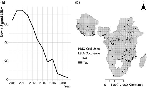
Data on LSLAs are drawn from the Land Matrix Initiative (Citation2022), which gathers qualitative and geographic information on ‘intended, concluded, and failed attempts to acquire land through purchase, lease or concession for a wide range of intended uses’ since 2000. I selected transnational land deals of a minimum of 200 ha for agricultural production, conservation, timber exploitation and renewable energies with a contract signed, but which were not necessarily implemented (some deals remained purely speculative, while others failed before any work could be done on the ground). Between 2008 and 2018, 468 parcels of land were leased or sold to foreign investors in 32 different SSA countries (see Table A1 in Appendix A in the supplemental data online). The spatial precision of the locations was validated by Messerli et al. (Citation2014): in my sample, 148 locations are precise at 0–10 km while 320 locations are precise at 10–100 km. It means that a data point is displaced by up to two units, which is accounted for when building the weight matrix. The dependent variable LSLA OCCURRENCE is binary and indicates whether at least one parcel of land was sold or leased to a foreign investor in unit i and year t. The variable was operationalized as binary due to the highly skewed nature of the data: 85,113 units never experience a LSLA, 388 units experience one land deal in year t, 29 units experience two land deals in year t, five units experience three land deals in year t and finally one experiences seven land deals in a single year. In the final variable specification, out of 85,536 unique cell-yearit, 423 receive at least one LSLA. (a) shows the temporal variation of LSLAs in SSA, while (b) visualizes the countries of my sample and the subnational units affected by LSLAs over the full timeframe.
Figure 1. Temporal and spatial distribution of large-scale land acquisitions (LSLAs).
3.3.2. Explanatory variables
The independent variable INFRASTRUCTURAL CAPACITY is the mean logged night-time light emission intensity in the cell-yearit. The satellite imagery data are provided by the Defense Meteorological Satellite Program (DMSP) Operational Linescan System (OLS) Night-time Lights Time Series. The data were recently calibrated by Chen et al. (Citation2021), which makes possible an analysis over the 2008–18 period, something previously impossible as the data were collected by two different satellites.
The models further include various control variables that could be operationalized at the subnational level. Considering the link between the size of the population and LSLAs (Osabuohien, Citation2014), yearly total logged POPULATION in the cell-yearit is calculated, based on the Oak Ridge National Laboratory LandScan data.Footnote5 As events of violence can deter FDIs and affect infrastructures (Trotter, Citation2016), I estimate a variable INSTABILITY based on the Armed Conflict Location & Event Dataset (Raleigh et al., Citation2010) yearly number of riots, battles and remote violence in the cell-yearit. I also include URBANIZATION, in percentage of the cell-yearit, based on the MODIS Land Cover MCD12Q1 classification (MODIS, Citation2020), to control for the fact that there is a strong bias in electrification of urban areas (Trotter, Citation2016). With the same land cover classification, I also calculated WATER, the percentage of the area of the cell-yearit that is covered by water, as these areas are more attractive for agriculture than drier ones. I further estimate CROPLAND, the percent of the cell-yearit’s area covered by cultivated cropland, to account for the fact that LSLAs may be located in areas where large territories are available for developing commercial agriculture. I also include the sum of RAINFALL in millimetres in the cell-yearit according to the CHIRPS Pentad satellite rainfall data (Funk et al., Citation2015),Footnote6 expecting LSLAs to target areas where rainfed crops are possible. As many commercial crops necessitate large amounts of water (palm oil, sugarcane, etc.), areas with low levels of rainfall should be less attractive. All control variables were rescaled by 100. Finally, explanatory variables are lagged in the statistical models to ensure temporal ordering hence data are collected for 2006–18. summarizes the descriptive statistics of the main variables of interest; for full descriptive statistics, see Table A2 in Appendix A in the supplemental data online.
Table 1. Descriptive statistics.
3.4. Empirical strategy
As Lee and Yu (Citation2012) demonstrated, omissions of either spatial or serial correlation lead to estimation biases. All of the variables considered have a Moran I’s p-value of 0.000, indicating they show patterns of spatial autocorrelation. To determine whether there is also spatial interdependence, I estimate a simple ordinary least squares regression including all of the variables and fixed effects of interest (see Table A3 in Appendix A in the supplemental data online). The Moran’s I statistic on the ordinary least squares residuals is significant, which confirms that the variables included in the models are not enough to account for all of the spatial interdependence in the dependent variable and spatial models are required. In addition, the LM test for error dependence (LMerr), the LM test for a missing spatially lagged dependent variable (LMlag), and a SARMA Portmanteau test all yield p-values below 0.000, indicating the presence of a missing spatial lag, error dependence, and potentially both. Models will therefore include both spatial and temporal parameters. For this, I primarily rely on a new R package built by Wucherpfennig et al. (Citation2021), as well as a package built by Millo and Piras (Citation2012).Footnote7 To estimate the models, a distance-based inverse weight matrix over 100 km is created. The matrix is row-standardized (normalized), and is 0-diagonal so observations are not neighbours to themselves.Footnote8
3.5. Pseudo-maximum likelihood for binary choice-dependent variable
The dependent variable is binary so a model that does not require a normality assumption is necessary. For this I use Wucherpfennig et al.’s (Citation2021) spatio-temporal pseudo-maximum likelihood estimator (SPMLE) for binary choice dependent variable in the statistical program R. Maximum likelihood estimations, which determine parameters so that they maximize the likelihood that the process described by the model produce the data that were actually observed, perform best for spatio-temporal models. The general model in matrix form is as follows:
where
is the binary {0;1} outcome variable in unit
and year
. The weight matrix
measures the spatial dependency between the units,
is the temporal connectivity matrix that links units’ current outcomes to their past realizations,
is a vector of covariates with corresponding parameters, and
is the error term (p. 3). In addition,
is the global spatial autocorrelation parameter, and
is the temporal correlation parameter. The above empirical specification therefore includes both a spatial lag
and a temporal lag
. With my data, it translates into the following equation:
There can be three issues with SPMLE models: (1) the usual omitted variable bias, partially accounted for with country
and year
fixed effects, respectively the
and
terms above; (2) currently it is not possible to derive direct, indirect and total effects from this function, although they greatly enhance the quality of interpretation (Whitten et al., Citation2021); and (3) to speed-up the estimation process, random shocks in unit
are not carried out through the off-diagonal elements, meaning higher order-effects of random shocks are ignored. Even with these limitations, Wucherpfennig et al. (Citation2021) found that their estimations covered the parameter values as well as other estimation alternatives.
3.6. Maximum likelihood estimations under normality assumption
The complementary choice to use the SPML package by Millo and Piras (Citation2012) allows me to calculate direct, indirect and total effects, but it estimates parameters with a normal-distribution assumption. As my dependent variable is binary, it means that standard errors are underestimated. The general spatial panel model of Millo and Piras is a linear probability model:
where
is an
vector of observations on the dependent variable,
is a vector of covariates, and
is the disturbance vector. Among the different specifications, I chose the maximum likelihood panel with a spatial lag, spatial random effects (Kapoor, Kelejian and Prucha-type dependence – KKP), AR(1) serial correlation and spatial error correlation, also called SAREM(2)SRRE (Millo, Citation2014, p. 16). Due to its inclusion of both serial and spatial correlation in the error term, and a spatial lag, it is the closest companion to Wucherpfennig et al.’s (Citation2021) SPMLE. With the KKP dependence specification, the same spatial process (correlation) applies to both errors and individual effects, with only first order spatial effects (i.e., direct neighbour). Thanks to this, the inversion of the weight matrix is considerably facilitated; considering the size of my weight matrix, it seemed to be the only possible option. In that case, the disturbance term is as follows:
where the random and idiosyncratic effects are spatially lagged, and the remainder errors
are serially correlated (for the full explanation, see Millo, Citation2014, pp. 4, 16). In models under non-normal distribution assumption (such as Wucherpfennig et al.’s, Citation2021, SPMLE), the independent variable effect is calculated in relation to the other variables, such as in an interaction term (Berry et al., Citation2010). Hence, to be consistent with the previous results, I interact INFRASTRUCTURAL CAPACITY with each control variables. With the variables for my empirical strategy, it translates into:
As we know, the random effect assumptionFootnote9 is a very strong one to make. However, random effects make more sense to answer my research question, as I am interested in the overall effect of my variables, and not just in within-unit change from one year to the next. In addition, my variables have little variability over time, which is problematic with within-variation model specification. In a similar vein as Millo and Carmeci (Citation2011), I argue that I control heterogeneity with country and year dummies.
4. RESULTS AND DISCUSSION
4.1. Zero-order effects of infrastructural capacity
I first estimate two models with the SPMLE specifications, without (model 1A) and with (model 1B) year and country fixed effects. visualizes the results, and the full results are reported in Table B1 in Appendix B in the supplemental data online. As coefficients in model 1B estimate the effect of change from one year to the next and from one country to another, they are more conservative estimations of the impacts.Footnote10 Furthermore, it is for now impossible to calculate direct, indirect and total effects for SPMLE with binary dependent variable. Coefficient estimates consequently represent zero-order effects of
on
and I can only use a coefficient interpretation approach (Whitten et al., Citation2021).
Figure 2. Spatio-temporal pseudo-maximum likelihood estimator (SPMLE) results without (a) and with (b) fixed effects. Outcome: LSLA OCCURRENCE.
Note: N = 7776, n = 85,536; panel length = 11 (balanced, 2008–18); inverse distance contiguity matrix, row normalized. Country fixed-effects, year fixed-effects and area of the cell are included. A collinearity check shows no multicollinearity between the variables.
Source: Author’s own calculations. For an associated table, see Table 1 in Appendix B in the supplemental data online.
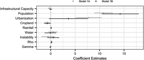
INFRASTRUCTURAL CAPACITY is negatively associated with the likelihood of a land deal being signed in the subnational cell-yearit in both models, although the size and significance of the effect decreases in model 1B , which is not surprising with the inclusion of country and year fixed effects (Millo & Carmeci, Citation2011). The results suggest an overall negative relationship between night-time lights and LSLAs, net of the effects of the control variables. This means that, when other covariates are controlled for, land deals are more likely to be situated in areas with comparatively weaker state infrastructural capacity. Thus, between 2008 and 2018, the extraversion theory has some weight in explaining the location of land deals. The results further show that POPULATION
and URBANIZATION
are positively associated with the likelihood of a LSLA. These coefficients indicate that while there is a narrative that territories for LSLAs are ‘distant’, ‘lawless’ or ‘ripe for investment’ (Wolford et al., Citation2013, p. 199), the areas targeted actually contain urban centres and significant number of people. The effect of URBANIZATION is also consistent with the agglomeration effect found by previous studies on the subnational determinants of FDIs (Hutzschenreuter et al., Citation2020, p. 6). Moreover, the positive effect of RAINFALL
and the negative effect of CROPLAND
support previous findings that LSLAs are resource-seeking investments: the areas targeted have comparatively fewer commercial crops, which allows investors to acquire very large parcels of land that are also suitable for rainfed agriculture. This further implies that the land targeted by LSLAs is not only appropriate for subsistence farming, but considering the positive effect of POPULATION, that it is most probably already used for such agriculture. Hence, my results support previous findings that territories used for community subsistence are the prime target for LSLAs (Dell’Angelo et al., Citation2017).
In model 1A, the global spatial autocorrelation parameter Rho is positive and significant , and in model 1B it is also positive
and almost significant (
. These indicate that the covariates
in unit i positively influence the likelihood of y in neighbouring units, and also that the
coefficients are under-estimated (Whitten et al., Citation2021). Finally, the temporal parameter
(Gamma) is negative in model 1B
, indicating that if a LSLA is signed in a unit at t – 1, it is less likely for another one to take place in the same unit at
(current year). This could be due to several factors, such as the necessity for large amount of arable land from the investors’ perspective, or from the ruling elites’ perspective, because capacity has been improved in the area, or to lessen problems with local communities by limiting land competition.
4.2. Interactions and spatial processes in LSLAs
To estimate direct, indirect and total effects, and not just a global spatial parameter ρ, and therefore use a general approach rather than a coefficient interpretation approach (Whitten et al., Citation2021), I replicate model 1B above with Millo and Piras’ (Citation2012) SAREM(2)SRRE model. Once again, only the visualizations of the estimates of model 2 are reported below (for the full table, see Table B2 in Appendix B in the supplemental data online).
Both spatial parameters of the model are significant, confirming the importance of modelling spatial effects to avoid estimations biases. The spatial lag is negative, indicating dissimilar values on the dependent variable between a unit
and its neighbours. The global spatial parameter
represents the intensity of the spatial dependency between our units: here, there is a positive spatial dependence, similar to the SPMLE models. The error variance further includes a positive serial correlation term
and a non-zero
, the ratio of the random effect’s variance to the idiosyncratic error’s one.
Overall, differentiating between direct, indirect and total impacts reveal that the explanatory variables have opposite zero- and higher order effects (). For the main explanatory variable, the effect of INFRASTRUCTURAL CAPACITY on LSLA OCCURRENCE can be disaggregated spatially: when the state has a comparatively stronger capacity in unit , land deals are less likely to be situated in that area
but will be ‘pushed’ to neighbouring
. However, the negative direct effect is almost four times stronger than the positive indirect effects, so that altogether INFRASTRUCTURAL CAPACITY is a negative predictor of land deals
. These results are thus consistent with the extraversion framework, through which I theorized that ruling elites avoid leasing or selling parcels of land in an area that is relatively well-developed in terms of infrastructure capacity. Methodologically speaking, disaggregating the effects also demonstrate the importance of a spatial analysis: in model 1A and 1B, the estimates are the zero-order or direct effects of the explanatory variables on LSLA OCCURRENCE, we are missing the indirect effects. Therefore, we cannot estimate the overall (total) effects of these variables, and we are missing part of the story. This implication can be extended to all the other explanatory variables.
Figure 3. SAREM(2)SRRE model 2 impacts on LSLA OCCURRENCE.
Note: N = 7776, n = 85,536; panel length = 11 (balanced, 2008–18); inverse distance contiguity matrix, row normalized; Kapoor, Kelejian and Prucha-type dependence (KKP) disturbance term with serial and spatial correlation. Spatial auto regressive spatial lag, country fixed-effects, year fixed-effects and area of the cell are included.
Source: Author’s own calculations. For an associated table, see Table 2 Appendix B in the supplemental data online.
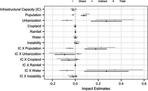
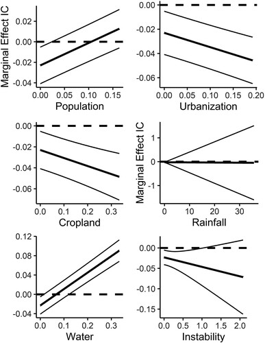
The model above also highlights that the effect of INFRASTRUCTURAL CAPACITY is dependent upon the other explanatory variables, as shown by strength of interaction terms and . In other words, the negative effect that INFRASTRUCTURAL CAPACITY has on the likelihood of a LSLA is strengthened when URBANIZATION, CROPLAND or INSTABILITY increase (b, c, f), while the effect is reduced when POPULATION and WATER increase (a,e), and is not affected by RAINFALL (d). Keeping in mind that interpreting the significance of the coefficients is hardly substantive, due to the underestimation of the standard errors, the figures show how the effect of INFRASTRUCTURAL CAPACITY on LSLA OCCURRENCE varies according to other variables values. On the whole, the effect remains largely negative, and becomes positive only for the extreme values of POPULATION and for most values of WATER.
Figure 4. Marginal Effects of INFRASTRUCTURAL CAPACITY (IC) on LSLA OCCURRENCE.
Note: See .
4.3. Robustness checks
Although the results are already consistent between models 1A, 1B and 2, I further reproduce models 1B and 2 with different specifications. First, the models are reproduced with the explanatory variables lagged of two years rather than one year, allowing for the possibility of effects that are further back in time. The effects of INFRASTRUCTURAL CAPACITY and WATER switch direction in the reproduction of model 1B, and the effects are very similar between model 2 and its reproduction with a lag at t – 2 (see Table C1 in Appendix C in the supplemental data online). Next, both models are reproduced with queen contiguity : the results are similar in direction, significance, and strength (see Table C2 in Appendix C online). In addition, a Hausman test comparing a fully random versus a within-variation specification of model 2 yields a p value of 0.000 (see Table C3 in Appendix C online). In that case, it is important to note that the within-variation results are very similar to the main results, indicating that an increase in INFRASTRUCTURAL REACH in a unit from one year to the next decreases the likelihood of a LSLA being signed in the unit. Yet, random effects remain preferable considering my research question, and the added fact that spatial and temporal dependence cannot be accounted for in a within-unit specification further support my choice to report the SAREM(2)SRRE specification as the most appropriate one (Bell et al., Citation2019). My findings are robust across various specifications, except for a lag t – 2 SPMLE, indicating that the results are not driven by a particular kind of model specification.
5. CONCLUSIONS
Large-scale investments in Sub-Saharan land by foreign companies have been charged with a wide array of negative consequences at the community-level, such as dispossession, impoverishment, or environmental degradation (e.g., Chiarelli et al., Citation2022; Dell’Angelo et al., Citation2021; International Land Coalition, Citation2011); at the national level, they are blamed for losses of food, territorial and social sovereignties (Mechiche-Alami et al., Citation2021; Sassen, Citation2013). My research shows another side of this story, where African ruling elites strategically use their comparatively weak positions in the international system to strengthen themselves domestically – in other words, an affair of extraversion (Bayart & Ellis, Citation2000). Concurrently, I identify the subnational determinants of LSLAs, a crucial contribution if we are to fully understand the global land rush and its local and national ramifications.
This article has theorized and then empirically demonstrated that, between 2008 and 2018, land deals were located in areas with comparatively weak infrastructural capacity, in the form of night-time light emissions. In a context of limited infrastructural capacity, it becomes attractive for ruling elites to outsource responsibility for public goods provisions to foreign investors. Through the granting of European-style land titles, without actually having to do the difficult and expensive task of providing social infrastructures, LSLAs are a relatively cheap way for ruling elites to assert that they are formally in charge. Considering that targeted territories have weak infrastructural capacity, it is also possible that ruling elites never had an intent to fully develop their states’ capacities on the ground – making LSLAs as a cheap extraversion strategy even more attractive. This domestic game plan can be aligned with investors’ own interests in case of a spatial fix of surplus capital (Harvey, Citation2004), or if they are state-operating companies (Khalid et al., Citation2021). Through their corporate social responsibility, investors are generally expected to compensate for states’ weak capacity on the ground by building infrastructures such as schools or clinics – that is, infrastructures that are typically provided by the state.
It is important to emphasize that the kind of power gained by states through LSLA processes is however not a ‘traditional’ form of state governance. This extraversion strategy embodies ‘neoliberal governance’ (Benegiamo, Citation2020, p. 47) and ‘private indirect government’ (Mbembé, Citation2000, p. 159): the state acts as a facilitator of capital’s incursion in new frontiers, by creating a discourse justifying the transfer of land rights, however the management of the new activities are left to the private entity. The investors notably acquire substantial rights to the land, sometimes for up to 99 years. This is why Sassen (Citation2013) argues that, once it goes through a process of foreign acquisition, the national territory is ‘disassembled’: it is integrated into global corporate circuits, and so are domestic elites (p. 28). Yet, while these parcels of land are integrated in global markets, the extraversion theory and my related findings demonstrate that the disassembling of the national territory can happen simultaneously with domestic reinforcement of state power – be it the removal of land resources from potential competitors and autonomous communities, the mapping and standardizing of the territory, or the discharge of responsibilities such as public good provision to foreign corporate entities. Consequently, investors are integral to state consolidation in these areas and shape current forms of African statehood.
The implications of my findings also go beyond matters of African statehood. Not only do LSLAs tend to target countries with relatively poor institutional performance and high levels of corruption (Bujko et al., Citation2016), my research shows that these investments are located in subnational territories with comparatively higher levels of population, urbanization, rainfall and non-commercial crops; consequently, competition for land-related resource is most likely exacerbated by their emplacement in these areas. In this context, the implementation of LSLAs can potentially (further) strain relations between citizens, investors, and ruling elites. Notably, corporate entities are usually neither able nor willing to endorse the role of public good providers (Pemunta, Citation2018). In the words of the General Director of SOCAPALM, a subsidiary of the French Bolloré group implemented in Cameroon for palm oil production, ‘shareholders of SOCAPALM did not join our venture to do social work. They have come only to make profit’ (Trait d’Union Magazine, Citation2016, present author’s translation and emphasis). Where there are situations of imbalanced powers between foreign investors and prior land users, their relations are increasingly characterized by coercion (Dell’Angelo et al., Citation2021, p. 3). And when local communities resist to LSLAs (Hall et al., Citation2015), they do so in response to different impacts, such as resistance to expulsion, land appropriation and concentration, or struggles for incorporation, resources distribution and rights recognition (Borras & Franco, Citation2013).
In the end, there are three important implications to my study. First, the narrative of ‘idle’ land hides a phenomenon of a weak state, rather than an absent population; problems associated with LSLAs are potentially exacerbated by poor local infrastructural capacity and increased competition for land. Second, efforts to make LSLAs ‘socially responsible’ will keep on failing if African ruling elites are using them to strategically avoid building infrastructures. In that situation, investors are not credible replacements for the state (Pemunta, Citation2018), especially considering that in the case of the ‘global land rush’, one third of the investors are financial entities and sovereign wealth funds that are more interested in land speculation rather than economic development (GRAIN, Citation2012). Finally, in the neoliberal post-structural adjustment programme era, states in SSA are playing an active politico-economic role, one of extraversion. Bayart and Ellis (Citation2000) theoretical framework can therefore be used with a quantitative empirical approach to study phenomena across the entire subcontinent, by considering indicators such as night-time light emission as indicators of state capacity. This final implication speaks to the necessity to construct a bridge between the quantitative realm and theories that were initially built on qualitative work, so we can collectively improve our scientific understanding of political dynamics in the Sub-Saharan region.
Supplemental Material
Download MS Word (46.2 KB)ACKNOWLEDGEMENTS
The author thanks Pauline Plagnat (University of Geneva), Didier Péclard (University of Geneva), Simon Hug (University of Geneva), Luca Messerschmidt (Technical University of Munich), Bert Kramar (University of Groningen), Antonio Savoia (University of Manchester), Imke Harbers (University of Amsterdam), Jessica Di Salvatore (University of Warwick), Aya Kachi (University of Basel), and the three anonymous reviewers for their valuable and insightful comments. In addition, the author thanks the University of Geneva’s High Performance Computing Center’s engineers for their help on Yggdrasil cluster resources.
DATA AVAILABILITY
Replication materials are available at Harvard Dataverse https://doi.org/10.7910/DVN/B7JY9S.
DISCLOSURE STATEMENT
No potential conflict of interest was reported by the authors.
Notes
1 All African countries, but the Arab Republic of Egypt, Tunisia, Algeria and Morocco; include only concluded deals that were initiated since 2008, and exclude the projects abandoned; all types of investments and intention of investments (including forest concessions); and transnational deals only.
2 The authors used road network and average time to the nearest city with 50,000 inhabitants.
3 The repertoire of ‘development’ is commonly used by African governments to legitimize actions that would otherwise anger various communities and actors due to their negative outcomes (Hagmann & Péclard, Citation2010).
4 For instance, Gagné (Citation2021) shows how the Senhuile-Senethanol company cleared the land of all trees and then put fences around its property to exclude local communities from accessing it, therefore acting its ownership of the land rights (p. 688). Throughout, Gagné shows how the company mobilized all its resources, being financial, institutional and discursive, to strengthen its claim to the territory it rented out.
5 This product was made using the LandScan (2000–18) High Resolution Global Population Data Set copyrighted by UT-Battelle, LLC, operator of Oak Ridge National Laboratory, under Contract No. DE-AC05-00OR22725 with the US Department of Energy. The US government has certain rights in this dataset.
6 Copyright 2022 MIT: Permission is hereby granted, free of charge, to any person obtaining a copy of this software and associated documentation files (the ‘Software’), to deal in the Software without restriction, including without limitation the rights to use, copy, modify, merge, publish, distribute, sublicense, and/or sell copies of the Software, and to permit persons to whom the Software is furnished to do so, subject to the following conditions: The above copyright notice and this permission notice shall be included in all copies or substantial portions of the Software.
7 Ideally, the empirical strategy would be a zero-inflated negative binomial regression (to account for processes that create excess zeros in the dependent variable) with spatial and temporal parameters, for which we could further estimate direct, indirect and total impacts. Temporal and spatial correlations are problematic for the estimation of count data models (Ahmad & Franck, Citation2016), which is why the SPMLE and SPML alternatives are the best current options.
8 With 7776 units over 11 panel waves, the dataset presents a problem that will be frequently encountered by political scientists: the computational cost of estimating models with so many units and parameters. This notably justifies the use of Wucherpfennig et al.’s (Citation2021) SPMLE package, which includes a Python speed-up. It was also necessary to use the University of Geneva’s High-Performance Computing facilities. For the analysis, the cluster Yggdrasil was used. It takes about two hours and 2 GB of RAM to run a SPMLE model with the Python speed-up; to estimate a SPML model, it takes on average 24 hours and 5 GB of RAM.
9 The unobserved individual effects are assumed to be uncorrelated with the other explanatory variables in the model, and can therefore be treated as components of the error term.
10 Both specifications present advantages and inconvenient: model 1A has a strong omitted variable bias, while standard errors are distorted in model 1B due to the inclusion of fixed effects. However, while the size and significance of the effects may change, their directions do not, indicating that the effects are robust.
REFERENCES
- Ahmad, A., & Francq, C. (2016). Poisson QMLE of count time series models. Journal of Time Series Analysis, 37(3), 291–314. https://doi.org/10.1111/jtsa.12167
- Aliye, A. (2020). Corporate social responsibility and business–community relations in Africa: The case of Ethiopia. Journal of Advanced Research in Economics and Administrative Sciences, 1(2), 77–90. https://doi.org/10.47631/jareas.v1i2.119
- Arezki, R., Deininger, K., & Selod, H. (2015). What drives the global “land rush”? The World Bank Economic Review, 29(2), 207–233. https://doi.org/10.1093/wber/lht034
- Bayart, J. F., & Ellis, S. (2000). Africa in the world: A history of extraversion. African Affairs, 99(395), 217–267. https://doi.org/10.1093/afraf/99.395.217
- Bell, A., Fairbrother, M., & Jones, K. (2019). Fixed and random effects models: Making an informed choice. Quality & Quantity, 53(2), 1051–1074. https://doi.org/10.1007/s11135-018-0802-x
- Benegiamo, M. (2020). Gouverner les frontières du développement: le retour de la question foncière et la «gestion» des investissements au Sénégal. Critique internationale, N°89(4), 29–51. https://doi.org/10.3917/crii.089.0032
- Berry, W. D., DeMeritt, J. H., & Esarey, J. (2010). Testing for interaction in binary logit and probit models: Is a product term essential? American Journal of Political Science, 54(1), 248–266. https://doi.org/10.1111/j.1540-5907.2009.00429.x
- Bigon, L. (2020). An infrastructure of light and darkness: In visual conversation with Baudouin Mouanda. Planning Perspectives, 35(3), 549–556. https://doi.org/10.1080/02665433.2020.1741433
- Borras, S. M. Jr, & Franco, J. C. (2013). Global land grabbing and political reactions ‘from below’. Third World Quarterly, 34(9), 1723–1747. https://doi.org/10.1080/01436597.2013.843845
- Borras, S. M. Jr, Hall, R., Scoones, I., White, B., & Wolford, W. (2011). Towards a better understanding of global land grabbing: An editorial introduction. The Journal of Peasant Studies, 38(2), 209–216. https://doi.org/10.1080/03066150.2011.559005
- Bujko, M., Fischer, C., Krieger, T., & Meierrieks, D. (2016). How institutions shape land deals: The role of corruption. Homo Oeconomicus, 33(3), 205–217. https://doi.org/10.1007/s41412-016-0021-4
- Buur, L., Pedersen, R. H., Nystrand, M. J., & Macuane, J. J. (2019). Understanding the three key relationships in natural resource investments in Africa: An analytical framework. The Extractive Industries and Society, 6(4), 1195–1204. https://doi.org/10.1016/j.exis.2019.11.009
- Carmody, P., & Taylor, D. (2016). Globalization, land grabbing, and the present-day colonial state in Uganda: Ecolonization and its impacts. The Journal of Environment & Development, 25(1), 100–126. https://doi.org/10.1177/1070496515622017
- Chen, Z., Yu, B., Yang, C., Zhou, Y., Yao, S., Qian, X., & Wu, J. (2021). An extended time series (2000–2018) of global NPP-VIIRS-like nighttime light data from a cross-sensor calibration. Earth System Science Data, 13(3), 889–906. https://doi.org/10.5194/essd-13-889-2021
- Chiarelli, D. D., D’Odorico, P., Müller, M. F., Mueller, N. D., Davis, K. F., Dell’Angelo, J., & Rulli, M. C. (2022). Competition for water induced by transnational land acquisitions for agriculture. Nature Communications, 13(1), 1–9. https://doi.org/10.1038/s41467-022-28077-2
- Conigliani, C., Cuffaro, N., & D’Agostino, G. (2018). Large-scale land investments and forests in Africa. Land Use Policy, 75, 651–660. https://doi.org/10.1016/j.landusepol.2018.02.005
- Cotula, L. (Ed.). (2007). Changes in “customary land tenure systems in Africa”. Russell Press.
- Cotula, L. (2013). The great African land grab? Agricultural investments and the global food system. Zed Books.
- De Angelis, M. (2007). The beginning of history: Value struggles and global capital. Pluto Press (UK).
- Dell’Angelo, J., D’Odorico, P., Rulli, M. C., & Marchand, P. (2017). The tragedy of the grabbed commons: Coercion and dispossession in the global land rush. World Development, 92, 1–12. https://doi.org/10.1016/j.worlddev.2016.11.005
- Dell’Angelo, J., Navas, G., Witteman, M., D’Alisa, G., Scheidel, A., & Temper, L. (2021). Commons grabbing and agribusiness: Violence, resistance and social mobilization. Ecological Economics, 184, 107004. https://doi.org/10.1016/j.ecolecon.2021.107004
- De Schutter, O. (2011). How not to think of land-grabbing: Three critiques of largescale investments in farmland. The Journal of Peasant Studies, 38(2), 249–279. https://doi.org/10.1080/03066150.2011.559008
- Funk, C., Peterson, P., Landsfeld, M., Pedreros, D., Verdin, J., Shukla, S., Husak, G., Rowland, J., Harrison, L., Hoell, A., & Michaelsen, J. (2015). The climate hazards infrared precipitation with stations—A new environmental record for monitoring extremes. Scientific Data, 2, 1500–1566. https://doi.org/10.1038/sdata.2015.66
- Gagné, M. (2021). Corporate repertoires of control and performances of power in a contested land deal in Senegal. African Studies Review, 64(3), 675–703. https://doi.org/10.1017/asr.2021.90
- German, L., Schoneveld, G., & Mwangi, E. (2011, April 6-8 ). Processes of largescale land acquisition by investors: Case studies from sub-Saharan Africa. International Conference on Global Land Grabbing, University of Sussex.
- Giovannetti, G., & Ticci, E. (2016). Determinants of biofuel-oriented land acquisitions in Sub-Saharan Africa. Renewable and Sustainable Energy Reviews, 54, 678–687. https://doi.org/10.1016/j.rser.2015.10.008
- GRAIN. (2012). Table: more than 400 largescale land acquisitions in the World [online]. http://www.grain.org/article/entries/4479-grain-releases-data-set-with-over-400-global-landgrabs.
- Grandia, L. (2013). Road mapping: Megaprojects and land grabs in the northern Guatemalan lowlands. Development and Change, 44(2), 233–259. https://doi.org/10.1111/dech.12020
- Hagmann, T., & Péclard, D. (2010). Negotiating statehood: Dynamics of power and domination in Africa. Development and Change, 41(4), 539–562. https://doi.org/10.1111/j.1467-7660.2010.01656.x
- Hall, D. (2013). Primitive accumulation, accumulation by dispossession and the global land grab. Third World Quarterly, 34(9), 1582–1604. https://doi.org/10.1080/01436597.2013.843854
- Hall, R., Edelman, M., Borras Jr., S.M., Scoones, I., White, B., & Wolford, W. (2015). Resistance, acquiescence or incorporation? An introduction to land grabbing and political reactions ‘from below’. The Journal of Peasant Studies. 42 (3–4), 467–488. https://doi.org/10.1080/03066150.2015.1036746
- Harbers, I. (2015). Taxation and the unequal reach of the state: Mapping state capacity in Ecuador. Governance, 28(3), 373–391. https://doi.org/10.1111/gove.12117
- Harvey, D. (2004). The ‘new’ imperialism: Accumulation by dispossession. Socialist Register, 40. 63.87. https://socialistregister.com/index.php/srv/article/view/5811
- Herbst, J. (2000). States and power in Africa: Comparative lessons in authority and control. Princeton University Press.
- Hutzschenreuter, T., Matt, T., & Kleindienst, I. (2020). Going subnational: A literature review and research agenda. Journal of World Business, 55(4), 101076. https://doi.org/10.1016/j.jwb.2020.101076
- Idemudia, U. (2011). Corporate social responsibility and developing countries: Moving the critical CSR research agenda in Africa forward. Progress in Development Studies, 11(1), 1–18. https://doi.org/10.1177/146499341001100101
- Ince, O. U. (2014). Primitive accumulation, new enclosures, and global land grabs: A theoretical intervention. Rural Sociology, 79(1), 104–131. https://doi.org/10.1111/ruso.12025
- International Land Coalition. (2011). Tirana declaration: Securing land access for the poor in times of intensified natural resources competition. Global assembly 2011, Tirana, Albania, May 24–27, 2011. (ILC 2011). https://www.landcoalition.org/documents/6/Tirana_Declaration_2011_EN.pdf
- Khalid, F., Sun, J., Huang, G., & Su, C. Y. (2021). Environmental, social and governance performance of Chinese multinationals: A comparison of state- and non-state-owned enterprises. Sustainability, 13(7), 4020. https://doi.org/10.3390/su13074020
- Koren, O., & Sarbahi, A. K. (2018). State capacity, insurgency, and civil war: A disaggregated analysis. International Studies Quarterly, 62(2), 274–288. https://doi.org/10.1093/isq/sqx076
- Lavers, T., & Boamah, F. (2016). The impact of agricultural investments on state capacity: A comparative analysis of Ethiopia and Ghana. Geoforum, 72, 94–103. https://doi.org/10.1016/j.geoforum.2016.02.004
- Lee, L., & Yu, J. (2012). Spatial panels: Random components versus fixed effects. International Economic Review, 53(4), 1369–1412. https://doi.org/10.1111/j.1468-2354.2012.00724.x
- Mann, M. (1984). The autonomous power of the state: Its origins, mechanisms and results. European Journal of Sociology/Archives européennes de sociologie, 25(2), 185–213. https://doi.org/10.1017/S0003975600004239
- Mazzocchi, C., Orsi, L., & Sali, G. (2021). Environmental, climate and socio-economic factors in large-scale land acquisitions (LSLAs). Climate Risk Management, 32, 100316. https://doi.org/10.1016/j.crm.2021.100316
- Mbembé, J. A. (2000). De la postcolonie: essai sur l’imagination politique dans l’Afrique contemporaine. KARTHALA Editions.
- Mechiche-Alami, A., Yagoubi, J., & Nicholas, K. A. (2021). Agricultural land acquisitions unlikely to address the food security needs of African countries. World Development, 141, 105384. https://doi.org/10.1016/j.worlddev.2020.105384
- Messerli, P., Giger, M., Dwyer, M. B., Breu, T., & Eckert, S. (2014). The geography of largescale land acquisitions: Analysing socio-ecological patterns of target contexts in the global south. Applied Geography, 53, 449–459. https://doi.org/10.1016/j.apgeog.2014.07.005
- Millo, G. (2014). Maximum likelihood estimation of spatially and serially correlated panels with random effects. Computational Statistics & Data Analysis, 71, 914–933. https://doi.org/10.1016/j.csda.2013.07.024
- Millo, G., & Carmeci, G. (2011). Non-life insurance consumption in Italy: A sub-regional panel data analysis. Journal of Geographical Systems, 13(3), 273–298. https://doi.org/10.1007/s10109-010-0125-5
- Millo, G., & Piras, G. (2012). Splm: Spatial panel data models in R. Journal of Statistical Software, 47(1), 1–38. https://doi.org/10.18637/jss.v047.i01
- Min, B. (2015). Power and the vote: Elections and electricity in the developing world. Cambridge University Press.
- MODIS. (2020). MODIS land cover type/dynamics. NASA MODIS: Moderate Resolution Imaging Spectroradiometer. https://modis.gsfc.nasa.gov/data/dataprod/mod12.php
- Nolte, K., & Ostermeier, M. (2017). Labour market effects of largescale agricultural investment: Conceptual considerations and estimated employment effects. World Development, 98, 430–446. https://doi.org/10.1016/j.worlddev.2017.05.012
- Osabuohien, E. S. (2014). Largescale agricultural land investments and local institutions in Africa: The Nigerian case. Land Use Policy, 39, 155–165. https://doi.org/10.1016/j.landusepol.2014.02.019
- Peiffer, C., & Englebert, P. (2012). Extraversion, vulnerability to donors, and political liberalization in Africa. African Affairs, 111(444), 355–378. https://doi.org/10.1093/afraf/ads029
- Pemunta, N. V. (2018). The logic of benevolent capitalism: The duplicity of Sithe Global Sustainable Oils: Cameroon land grab and deforestation scheme as sustainable investment. International Journal of Global Environmental Issues, 17(1), 80–109. https://doi.org/10.1504/IJGENVI.2018.090655
- PKA. (2015, January). Principles for Responsible Investments in Farmland. PKA. https://www.pka.dk/globalassets/om-pka/sadan-investerer-vi/dokumenter/farmland-report—pka.pdf
- PRIO-GRID 2.0. (2021). About. https://grid.prio.org/#/about
- Raleigh, C., Linke, A., Hegre, H., & Karlsen, J. (2010). Introducing ACLED: An armed conflict location and event dataset. Journal of Peace Research, 47(5), 651–660. https://doi.org/10.1177/0022343310378914
- Reno, W. (2004). The collapse of Sierra Leone and the emergence of multiple states-within-states. In P. Kingston & I. S. Spears (Eds.), States-within-states (pp. 47–65). Palgrave Macmillan.
- Sassen, S. (2013). Land grabs today: Feeding the disassembling of national territory. Globalizations, 10(1), 25–46. https://doi.org/10.1080/14747731.2013.760927
- Schetter, C., & Müller-Koné, M. (2021). Frontiers’ violence: The interplay of state of exception, frontier habitus, and organized violence. Political Geography, 87, 102370. https://doi.org/10.1016/j.polgeo.2021.102370
- Schoneveld, G. C. (2017). Host country governance and the African land rush: 7 reasons why largescale farmland investments fail to contribute to sustainable development. Geoforum, 83, 119–132. https://doi.org/10.1016/j.geoforum.2016.12.007
- Scott, J. C. (1998). Seeing like a state. Yale university Press.
- Soifer, H. (2008). State infrastructural power: Approaches to conceptualization and measurement. Studies in Comparative International Development, 43(3–4), 231–251. https://doi.org/10.1007/s12116-008-9028-6
- The Land Matrix Initiative. (2022). International Land Coalition (ILC), The, Centre de Coopération Internationale en Recherche Agronomique pour le Développement (CIRAD), Centre for Development and Environment (CDE), German Institute of Global and Area Studies (GIGA) and Deutsche Gesellschaft für Internationale Zusammenarbeit (GIZ). https://landmatrix.org/
- Tollefsen, A. F., Bahgat, K., Nordkvelle, J., & Buhaug, H. (2015). PRIO-GRID v.2.0 Codebook. Peace Research Institute Oslo.
- Trait d’Union Magazine. (2016, May/June). Entretien avec Bedime Bedime. Train d’Union Magazine, pp. 15–16.
- Trotter, P. A. (2016). Rural electrification, electrification inequality and democratic institutions in sub-Saharan Africa. Energy for Sustainable Development, 34, 111–129. https://doi.org/10.1016/j.esd.2016.07.008
- Whitfield, L., Therkildsen, O., Buur, L., & Kjær, M. (2015). The politics of African industrial policy: A comparative perspective. Cambridge University Press.
- Whitten, G. D., Williams, L. K., & Wimpy, C. (2021). Interpretation: The final spatial frontier. Political Science Research and Methods, 9(1), 140–156. https://doi.org/10.1017/psrm.2019.9
- Wily, L. A. (2011). ‘The law is to blame’: The vulnerable status of common property rights in sub-Saharan Africa. Development and Change, 42(3), 733–757. https://doi.org/10.1111/j.1467-7660.2011.01712.x
- Wily, L. A. (2013). Enclosure revisited: Putting the global land rush in historical perspective. In Allan & Keulertz (Eds.), Handbook of land and water grabs in Africa: Foreign direct investment and good and water security (pp. 11–23). Routledge.
- Wolford, W., Borras, S. M. Jr, Hall, R., Scoones, I., & White, B. (2013). Governing global land deals: The role of the state in the rush for land. Development and Change, 44(2), 189–210. https://doi.org/10.1111/dech.12017
- Wong, D. W. (2004). The modifiable areal unit problem (MAUP). In D. G. Janelle, B. Warf, & K. Hansen (Eds.), Worldminds: Geographical perspectives on 100 problems (pp. 571–575). Springer.
- World Bank. (2010). Rising global interest in farmland: Can it yield sustainable and equitable benefits? World Bank.
- Wucherpfennig, J., Kachi, A., Bormann, N. C., & Hunziker, P. (2021). A fast estimator for binary choice models with spatial, temporal, and spatio-temporal interdependence. Political Analysis, 29(4), 1–7. https://doi.org/10.1017/pan.2020.54