
 ?Mathematical formulae have been encoded as MathML and are displayed in this HTML version using MathJax in order to improve their display. Uncheck the box to turn MathJax off. This feature requires Javascript. Click on a formula to zoom.
Abstract
The landslide-induced surge of river type reservoir in the mountainous area has become one of the most important disasters affecting the waterborne transportation and the safety of human life and property in the reservoir area. Based on the field observation of landslide and landslide-induced surge in the Three Gorges Reservoir (TGR) area and relevant research results, this paper develops the basic principles for selecting the risk factors of landslide-induced surge, analyses the risk factors of landslide-induced surge, and gives the main and secondary risk factors and their characteristics. According to the characteristics of landslide-induced surge disaster, the hierarchical structure, judgment matrix, and risk calculation model suitable for landslide-induced surge disaster are established by using analytic hierarchy process method, and the classification standard of the action index of each main evaluation factor is determined. This well-developed evaluation method is then applied to evaluate the risk of Hongyanzi landslide-induced surge disaster in the TGR area. The evaluation result is high risk, which is consistent with the actual disaster situation.
1. Preface
As a kind of swell, the landslide-induced surge has a large energy and spreadability, which makes it very destructive. The surge will bring great threat to the nearby water area and the service-life of the ships, channel, wharf auxiliary facilities, and other structures and local residents in the spreading area after the landslide enters the water. In serious cases, it can destroy the ships, wharf, dam and other structures, or even cut off the river, obstruct the channel and cause the navigation interruption. It is of great significance to carry out the risk assessment of landslide-induced surge disaster, to reasonably determine the risk level of disaster, and to select the countermeasures and measures for disaster prevention and mitigation, so as to ensure the safety of human economic activities and reduce disaster losses.
At present, there are many studies on the risk assessment of geological disasters such as landslides and collapses (Erener & Düzgün, Citation2013), including the initial wave height, wave runup, wave propagation, and energy dissipation, flow field caused by the wave and the impact of the wave on navigation (Wang et al., Citation2019; Yuan et al., Citation2019). However, there are few studies on the risk assessment of the landslide-induced wave. Slingerland and VoightPaolo (Citation1982) investigated the phenomenon of landslide-induced surge disaster assessment, which was further discussed by Huber (Citation1984). Wieczorek et al. (Citation2003) pre-assessed the landslide-induced surge disaster at the tidal estuary of Glacier Bay National Park in the United States. Gusiakov (Citation2008) studied the catalogue of the sea surge disaster and risk assessment, and Wang et al. (Citation2014) took Baishuihe landslide-induced surge as an example. Lin et al. (Citation2019) established a safety assessment system for landslide-induced surge of river reservoir based on GIS.
In the existing disaster risk evaluation, the popular or well-developed evaluation methods mainly include comprehensive index method, fuzzy comprehensive evaluation method, and chromatography analysis method (Qi, Citation2008; Yang, Citation2014). Comprehensive index method is a method of statistical analysis by using comprehensive index, which needs a lot of original data. Fuzzy comprehensive evaluation method is a method of comprehensive evaluation by using the characteristics of fuzzy relation synthesis, from multiple indexes to the subordinate level of the evaluated things, which is a method of simulating some thinking modes of human brain, with certain uncertainty. Analytic hierarchy process (AHP) is a systematic, flexible, concise, and practical multi-factor decision analysis method combining qualitative and quantitative analysis, which was put forward by Professor T.L. Saaty, an American operational research scientist, in the early 1970s (Yi, Citation2000). It is an effective system analysis method for the combination of qualitative and quantitative problems in system engineering (Wang, Citation2011; Xu, Citation1988). This paper takes Hongyanzi landslide-induced surge in the Three Gorges Reservoir (TGR) area as an example and uses the AHP technology to establish a hierarchical structure model suitable for landslide-induced surge disasters according to the characteristics of the problem to be solved. The main factors of the surge wave are quantitatively evaluated, and the impact of various factors is comprehensively considered to evaluate the risk of the landslide-induced surge disaster.
2. Selection of risk assessment factors of landslide-induced surge
2.1. Principles for selection of evaluation factors
The risk assessment of landslide-induced surge should combine the hazard range of landslide-induced surge with the factors of human engineering economic activities and carry out a general and comprehensive risk assessment. Because there are many factors affecting the generation and propagation of landslide and its induced surge, and the influence degree of each factor on its risk is different. In the case of not fully considering all factors and their interrelations, the main factors should be selected and the influence of secondary factors should be ignored. The risk assessment of landslide-induced surge should adopt the combination of qualitative and quantitative methods, select quantitative analysis as the mathematical expression of qualitative analysis, and take the results of qualitative analysis as the framework of constraint quantitative evaluation.
The evaluation index system is composed of several single evaluation indexes (factors). It should reflect the objectives and requirements of the risk prediction of landslide-induced surge disaster, being comprehensive, reasonable, scientific, and practical, and being accepted by relevant personnel and departments. However, due to various reasons, such as the depth of research, the requirements of various industries and different priorities, China has not yet established a unified and standardized evaluation system of landslide-induced surge disaster indicators, and there are many evaluation systems composed of a single or a few indicators. Although all kinds of evaluation index systems are designed to establish a generally applicable evaluation index system, some focus on the selection of indicators, some focus on the quantitative methods of indicators because of the different focuses (Ali et al, Citation2014). Based on the characteristics of landslide-induced surge in the TGR area, this paper discusses the establishment principle of the index system. It no longer takes universality as the first principle of constructing the evaluation index system, but emphasizes the basic criteria of specific analysis of specific problems, and emphasizes that the specific situation of the evaluation research area should be fully considered under the framework of general adaptability. Therefore, the comprehensive and systematic consideration of the trigger and disaster-causing factors that control and influence the occurrence of landslide-induced surge disasters should be included in the determination of the evaluation index system. The evaluation index strives to be concise, operable, and targeted while making every factor as simple as possible. Meanwhile, they are independent of each other, and the basic principles such as major and minor factors should be distinguished.
2.2. Selection of evaluation factors
Based on the field investigation, field data analysis, physical model test, and numerical simulation of the research object, the main factors affecting the height of landslide-induced surge are landslide volume, slope of sliding surface, initial position of landslide, state of water body and exchange degree (Han et al., Citation2019). Among them, the volume and initial position of the landslide reflect the total potential energy of the landslide, the angle of the sliding surface controls the sliding speed before the landslide enters the water, and the operation level of the reservoir (water depth of the reservoir) controls the state and exchange degree of the water body. Therefore, the main factors that affect the generation and height of the surge are the volume of the landslide, the slope of the sliding surface, the initial position of the landslide, and the operating water level of the reservoir (the water depth of the reservoir), which are called as the disaster trigger environment. After the formation of the surge, the propagation along the reservoir and the wave runup along the bank will affect the safety of various disaster-bearing bodies (such as residential areas, ports and docks, roads and bridges, water conservancy facilities, waterway facilities, municipal facilities, and passing ships), resulting in disaster losses (Zhiyou et al., Citation2018). Therefore, the characteristics of propagation wave height and surge runup are the important factors leading to surge disaster. Other factors, such as landslide structure, rock and soil properties, reservoir water velocity, can be used as reference factors.
Disaster trigger environment
It mainly includes the scale of the landslide, the slope of the landslide, the initial position of the landslide, and the operating water level of the reservoir.
The impact of the scale of the landslide on the landslide-induced surge is obvious. As the scale of the landslide increases, the potential danger or harm of the landslide increases rapidly. Generally speaking, the volume of landslides indicates the scale of landslides, and there is no uniform division standard so far. The commonly used grade standards generally follow the technical standards of the China Geological Survey: small landslide volume is less than 1 × 10⁴ m3; medium landslide volume is 1 × 10⁴ m3 to 10 × 104 m3; large landslide volume is 10 × 104 m3 to 100 × 104 m3; extra large landslide volume is 100 × 104 m3 to 1000 × 104 m3; the volume of giant landslide is more than 100 million m3. According to the statistics of the geometric shape and characteristics of rock mass landslides in the TGR area, the volume of rock mass landslides in the reservoir area is mainly large- or medium-sized. Because the scale of landslide is directly proportional to the risk degree of surge and its induced disaster loss, this paper selects the landslide scale with the volume of 1 × 10⁴ m3 and 10 × 104 m3 as the evaluation criteria.
The slope of the sliding surface determines the movement form of the landslide and the sliding speed before entering the water. Different from rock landslides, collapse (dangerous rock mass) and steep rock mass landslides are sudden and sharp fall movements of rock and soil mass on steep hillsides under the action of gravity, which usually occur on mountain with a slope larger than 60° to 70° and mostly occur in rock sections with hard lithology. Due to the high hardness of rock mass, the scale of landslides is smaller than that of earth rock landslides, and the rock mass still remains in the process of falling with a better integrity. However, the material composition of rock landslides is mainly composed of mudstone and sandstone with small hardness, which are widely distributed in the TGR. The scale is usually large or medium-sized (10 to 1000 × 104 m3). Due to the fracture development and geological structure, they are nearly scattered in the process of sliding and entering the water. Based on the statistical analysis of the slope of sliding surface of typical rock landslides in the TGR area, it is found that the slope of the sliding surface of rock landslides is between 16° and 64° (average value: 38.5°). Therefore, this paper focuses on the selection of 20° and 40° rock landslide slope level as the evaluation criteria.
In addition to the landslide volume and slope angle, the mechanism of surge also depends on the initial position of the landslide relative to the surface of still water, that is, the water state of the landslide. According to the different initial position, it can be divided into an overwater landslide, partially submerged landslide and underwater landslide. The initial surge generated by overwater landslide includes solid, liquid, and gas, which is mainly formed on the surface of water body, and its local amplitude is larger than that of partially submerged landslide and underwater landslide. Compared with the overwater landslide, the sliding speed of the partially submerged landslide is slower, but the initial surge generated by the landslide still belongs to the mixed flow of solid, liquid, and gas. One part of the initial surge is formed on the surface of the water body, the other part is formed underwater, and the local wave amplitude is between the overwater landslide and the underwater landslide. However, the local surge generated by the underwater landslide is far less than the type of landslide and partially submerged landslide, and the sliding speed is also slower. The initial surge only contains solid and liquid phases, and all of them are formed underwater. Therefore, according to the initial position of the landslide relative to the static water surface of the reservoir, this paper takes overwater landslide, partially submerged landslide and underwater landslide as the evaluation criteria.
The operating water level of the reservoir affects the initial wave height when the surge occurs. According to the existing wave height test of the initial wave height of rock mass landslide under three operating water levels of the TGR, it is concluded that the initial wave height of the same volume landslide decreases with the increase of water depth in the reservoir when the water inflow angle is the same. With the rise of water level, the water body is more and more abundant. In the process of energy exchange between landslide and water body, the energy lost is enhanced. Therefore, the greater the water depth is, the greater the energy consumption of the initial wave height is, and the smaller the initial wave height is. In this paper, the three-stage water level (145, 155, 175 m) in the operation of the TGR is used as the criterion of low, medium, and high water level.
Surge characteristics
It mainly includes propagation wave height and surge wave runup.
The initial surge of landslide-induced surge is a complex wave combining progressive wave and oscillating wave. In the process of propagation, surge is affected by friction resistance, leading to a reduction of wave height and energy loss. In practice, the scope of water traffic control and various facilities protection for landslide-induced surge disaster can be determined according to the initial and propagation wave height. Among the landslide-induced surge disasters that have occurred, the frequency of the hazards to ships is the most prominent. Therefore, special attention needs to be given to the impact of the surge height on the safety of the ship. In other words, the degree of impact of the surge height on ship safety in case of the ship being fully loaded can be adopted. According to the data statistics of inland river ship type parameters and design draught, it can be found that the maximum wave height of Navigable Ship is generally 0.4–0.6 m, which is basically consistent with the range of 0.5–0.6 m of lock discharge limit standard (Haiyong et al., Citation2015). Considering the adverse effects, the upper limit of surge height is 0.4 m.
The determination of the local wave runup is a very important parameter in the hazard prediction and disaster reduction design of the bank slope, buildings and local residents. It directly affects the stability of the bank slope, buildings (such as residential areas, ports, roads and bridges, water conservancy facilities, waterway facilities, and municipal facilities) and the life safety of the residents. As many human engineering economic activities fail to fully realize the danger of landslide-induced surge, it often causes casualties and various property losses. In the risk assessment of landslide-induced surge, people-oriented should be taken into account, and the impact of surge runup on the people on the shore should be considered. Generally, it can be discriminated and analysed according to the children of 0.5–1 m height. In this paper, 0.5 and 1 m surge heights are selected as the evaluation criteria.
In summary, six factors that have a greater impact on landslide-induced surge disasters are selected for this evaluation as landslide scale, landslide slope, initial position of the landslide body, reservoir operating water level, spread wave height, and surge climb. The main evaluation factor is to establish the hierarchical structure model to evaluate the danger of landslide-induced surge.
3. Risk assessment model of landslide-induced surge disaster
3.1. Establishment of hierarchy model for risk assessment of landslide-induced surge
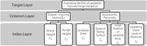
The idea of AHP is to firstl decompose the complex problem into several levels and its related dominating factors, then calculate and compare each factor, so as to obtain the weight value of different dominating factors, and finally provide decision-making basis for the analysis and solution of the problem. When applying AHP to analyse multi-factor decision-making problems, we need firstly establish a hierarchical level and construct a hierarchical structural model, which can generally be divided into the highest level (target level), middle level (criteria level), and bottom level (indicator level). The elements of the previous level dominate the elements of the next level. Each element in each level generally contains no more than nine elements. After various data and information of landslide are analysed and processed, six factors related to the formation of landslide are extracted: propagation wave height (C1), surge runup (C2), landslide scale (C3), slope of sliding surface (C4), initial position of landslide body (C5), operating water level of reservoir (C6) as index layer (second layer), together with the disaster-causing factors (B1), and trigger of criterion layer (first layer) hazard factor (B2), establishing the hierarchical structure model, and evaluating the risk of landslide-induced surge hazard (A). The hierarchy of landslide risk assessment is shown in Figure .
Figure 1. Hierarchy of landslide-induced surge risk assessment.
3.2. Construction of judgment matrix
The judgment matrix represents the comparison of the relative importance between the relevant factors in this level compared with a certain factor in the previous level. The analytic hierarchy process uses the 1–9 scale method to give the quantitative scale for the evaluation of different situations. That is, any two evaluation indicators are compared item by item, while referring to expert opinions to determine their relative importance and assigning corresponding scores to construct a judgment matrix. Therefore, it is necessary to start from the second layer of the hierarchical structure model, and use the numbers 1–9 and its reciprocal as the scale to construct a pair of judgment matrices for each factor of the same layer that belongs to each factor of the upper layer, until the lowest layer. Its form is shown in Tables .
Table 1. Judgment matrix of A-B layer.
Table 2. Judgment matrix of B1-C layer.
Table 3. Judgment matrix of B2-C layer.
Table 4. Judgment matrix of A-C layer.
Then, the feature vector w is solved by hierarchical single sorting. Hierarchical single ranking refers to calculating the weight of the importance order of each factor related to the previous level according to the judgment matrix (Gu et al., Citation2009). Its purpose is to calculate the maximum eigenvalue and the corresponding eigenvector for each pair of judgment matrix by the summation method. According to the square root method, the calculation steps are as follows:
Calculate the product
of each row element of judgment matrix B:
(1)
(1) where xi, xj (i, j = 1, 2, … , n) for each factor. xij is the value of the relative importance of xi to xj.
Calculate the n-th root
of
:
(2)
(2)
Normalize the vector
to get the weight
:
(3)
(3) Then, W=
is the feature vector, that is, the weight value of each index.
Finally, the consistency test is carried out to judge whether the above eigenvectors are reasonable. Consistency test is used to test the constructed judgment matrix. If the test results are within the allowable range, the ranking results are valid. Otherwise, the judgment matrix needs to be readjusted until it is reasonable. The method is as follows:
Calculate the maximum eigenvalue
of judgment matrix:
(4)
(4)
(5)
(5) Among them,
is the maximum eigenvalue of judgment matrix B; n is the number of pairwise comparison factors;
is the component of W, which is the single-order weight value of the corresponding element; W is the normalized eigenvector corresponding to
.
Calculate the consistency indicator CI and find the consistency indicator RI:
(6)
(6) In the formula, the greater the CI value, the worse the consistency of the judgment matrix. When CI = 0, the judgment matrix has full consistency. Then, check the table to determine the corresponding average random consistency index RI, and compare CI with RI to check whether the judgment matrix is consistent. See Table for the index value.
(7)
(7)
Table 5. Average random consistency index chart.
Calculate consistency ratio:
When CR <0.10, the consistency of the judgment matrix is acceptable. When CR > 0.10, the judgment matrix does not meet the consistency requirements, and it should be appropriately modified until the consistency is satisfied.
3.3. Classification of evaluation factors
The classification of risk factors is based on the actual situation of landslide-induced surge disaster in the study area, to evaluate the risk factors of landslide-induced surge. The aforementioned six risk factors are divided into three levels, and the specific classification and the determination criteria of different levels are shown in Table .
Table 6. Classification of evaluation factors and determination criteria for different levels.
The action index is a physical quantity that represents the action size or strength of each factor in landslide risk identification, which is a relatively comparative value and a quantitative expression of qualitative analysis. In recent years, many researchers agree that ‘golden section’ method (Qi, Citation2008), not only can be widely used in the long and wide sections of rectangular objects, but also exists in people's analytical epistemology. For example, there are main and secondary reasons leading to the formation of a natural phenomenon. The main and secondary mathematical sections can still be divided by the proportion coefficient of 0.618. Usually, people use the golden section method to determine the proportional relationship between the effects of geological hazard risk assessment factors, so as to avoid the randomness of the distribution factor action index. In this study, the principle of ‘golden section’ is used to determine the classification standard of the action index of each evaluation factor for landslide-induced surge. In other words, the action index with high risk is taken as 1, the action index with medium risk is taken as 0.618, and the action index with low risk is taken as 0.382, which is represented by V1, V2 and V3, where V1 corresponds to high risk, V2 corresponds to medium risk, and V3 corresponds to low risk V = {V1, V2, V3} = {high risk, medium risk, low risk} = {1, 0.618, 0.382}.
3.4. Evaluation model
Quantitative indicators for risk assessment are obtained by calculating the risk index. The calculation model for landslide-induced surge risk is:
(8)
(8) In the formula,
is the landslide risk factor;
is the weight vector of discrimination factor;
is the action index of discrimination factor. Risk classification standard can be referred to Table .
Table 7. Criteria for risk classification.
4. Example of landslide-induced surge disaster risk assessment
Since the implementation of the 175 m testing impoundment in the TGR in September 2008, a large number of landslides and bank collapses have occurred on both sides of the reservoir area. For example, at 18:40 on 24 June 2015, a large-scale landslide (Hongyanzi landslide) broke out on the North Bank of Jiangdongsi, the mouth of Daning River in Wushan, Chongqing. About 230,000 m3 of rock and soil mass slid into Daning River with a high speed, generating a huge swell of about 6 m high in the near field. Although the Wushan Authority had evacuated residents around the landslide area before the landslide arrived, and arranged all operating vessels on the Daning River to dock in the port. Due to inaccurate estimation of the intensity and danger of the swell wave attenuation, the shore wave unfortunately caused the sinking of a 14 m-long sea cruiser docked on the opposite side of the landslide body, the overthrow of nine small fishing boats and seven self-used ships. In addition, two people were killed and four injured due to local surge runup. In this study, the risk degree of Hongyanzi landslide-induced surge disaster is evaluated by the above evaluation method.
Determination and calculation of judgment matrix
According to the field survey, the average slope of the landslide mass is 34°, the total volume of the landslide mass is 23 × 104m3, the length of the water part of the landslide mass is 130 m, the water depth in the area near the landslide is 25 m (the water level of the TGR is in operation), the initial wave height is 6 m, the runup is 1.3 m, and the propagation wave height is greater than 0.6 m. On the basis of the field data and consultancy of the relevant experts, the judgment matrix of each level is determined according to the AHP.
The evaluation matrix of Hongyanzi surging landslide evaluation factor is shown in Tables .
Table 8. Judgment matrix of layer A-B.
Table 9. Judgment matrix of layer B1-C.
Table 10. Judgment matrix of layer B2-C.
Table 11. General layer judgment matrix A-C.
CR = 0 < 0.1, so the judgment matrix satisfies the consistency check, and the above feature vector W can be used as a weight vector.
CR = 0 < 0.1, so the judgment matrix satisfies the consistency check, and the above feature vector W can be used as a weight vector.
CR = 0.059 < 0.1, so the judgment matrix satisfies the consistency check, and the above-mentioned feature vector W can be used as a weight vector.
Consistency check of hierarchical total ordering: CR = 0, satisfying the consistency check.
Value index of Hongyanzi landslide evaluation factor
See Table for the action index of each evaluation factor of Hongyanzi landslide-induced surge.
Table 12. Effect factors of evaluation factors of swell waves in Hongyanzi landslide.
Risk index of Hongyanzi landslide
According to Tables and , using formula (9), = 0.9327.
Risk assessment results of landslide-induced surge
According to the above calculation results, Hongyanzi landslide has a high risk of surge (Grade I). This is consistent with the actual disaster situation. It can be seen that it is feasible to use AHP to evaluate the risk of landslide-induced surge. Therefore, this method can be used to evaluate and determine the risk level of other possible landslide-induced surge disasters, so as to provide reference for landslide-induced surge prevention and scientific decision-making.
5. Conclusions
The risk assessment of landslide-induced surge should be based on the combination of qualitative and quantitative methods and the selection of main factors. In the process of risk assessment and analysis, in order to meet the needs of risk analysis, through the comprehensive comparison of a large number of prototype observation data and research results, the main risk factors of landslide-induced surge disaster are selected as landslide scale, slope of sliding surface, initial position of landslide mass, operation water level of reservoir, propagation wave height and surge runup.
According to the characteristics of landslide surge disaster, the hierarchical structure, judgment matrix and risk calculation model suitable for landslide surge disaster are established by using the AHP method. The ‘golden section’ method is used to determine the classification standard of the action index of each main evaluation factor, and the risk grade and corresponding assignment of landslide surge disaster are given respectively for landslide scale, slope of sliding surface, initial position of landslide mass, operation water level of reservoir, propagation wave height, and surge climbing height.
Using the evaluation method in this study, the risk of Hongyanzi landslide-induced surge disaster of Daning River in TGR area is evaluated, and the weight of evaluation index and the calculation result of risk degree are given. The risk assessment result of the landslide-induced surge disaster is high risk (Grade I), which is consistent with the actual disaster situation. It can be seen that it is feasible to use AHP to evaluate the risk of landslide-induced surge, which provides a reference for the risk assessment and prevention of other possible landslide-induced surge disasters.
Acknowledgements
This study is supported by the National Natural Science Foundation of China (No. 51479015), Chongqing Basic Science and Advanced Technology Program (cstc2017jcyjBX0070).
Disclosure statement
No potential conflict of interest was reported by the author(s).
Additional information
Funding
References
- Ali, A., Huang, J., Lyamin, A. V., Sloan, S. W., Griffiths, D. V., Cassidy, M. J., & Li, J. H. (2014). Simplified quantitative risk assessment of rainfall-induced landslides modelled by infinite slopes. Engineering Geology, 179, 102–116. https://doi.org/10.1016/j.enggeo.2014.06.024
- Erener, A., & Düzgün, H. B. S. (2013). A regional scale quantitative risk assessment for landslides: Case of Kumluca watershed in Bartin, Turkey. Landslides, 10(1), 55–73. https://doi.org/10.1007/s10346-012-0317-9
- Gu, X. Z., Peng, Y. Q., & Chen, H. K. (2009). Study on landslide risk of fengjiaba, Wushan, Three Gorges Reservoir Area. Journal of Chongqing Jiaotong University (NATURAL SCIENCE EDITION), 28(4), 724–727. https://doi.org/CNKI:SUN:CQJT.0.2009-04-022
- Gusiakov, V. K. (2008). An integrated tsunami research and information system: Application for mapping of tsunami hazard and risk assessment. Solutions to Coastal Disasters 2008: Tsunamis Coastal Disasters and Solutions 2008. American Society of Civil Engineers. pp. 27–38.
- Haiyong, X. U., Pingyi, W. A. N. G., & Tao, Y. U. (2015). Experimental studies of safety scope for ships’ anchorage under landslide generated waves. Yangtze River, 46(15), 78–81. https://doi.org/10.16232/j.cnki.1001-4179.2015.15.019
- Han, L. F., Wang, P. Y., Wang, M. L., & Liu, Y. (2019). Motion characteristics of cataclastic rockslides and change rules of impulse waves in near-field zone. Journal of Zhejiang University (Engineering Science), 53(12), 2325–2334. https://doi.org/10.3785/j.issn.1008-973X.2019.12.009.
- Huber, A. (Feb 1984). Discussion of “evaluating hazard of landslide-induced water waves” by Rudy Slingerland and Barry Voight (November, 1982). Journal of Waterway, Port, Coastal, and Ocean Engineering, 110(1), 111–113. https://doi.org/10.1061/(ASCE)0733-950X(1984)110:1(111)
- Lin, X. S., Luo, H. J., Wang, P. Y., Wang, M. L, Yu, T., & Gong, Y. H. (2019). Design and implementation of safety assessment system for landslide surge in river type reservoir. Journal of Chongqing Jiaotong University(Natural Science), 38(1), 55–61. https://doi.org/10.3969/j.issn.1674-0696.2019.01.09
- Qi, H. L. (2008). Study on the evaluation and prevention of geological hazards of Highway Subgrade. Xi'an.
- Slingerland, R., & VoightPaolo, B. (1982). Evaluating hazard of landslide-induced water waves. Journal of the Waterway Port Coastal and Oeean Division, 1089(4), 504–512. https://doi.org/10.1016/0022-1694(82)90165-2.
- Wang, W. (2011). Application of analytic hierarchy process in system of evaluation for sustainable transport system. Beifang Jiaotong, 7, 68–70. https://doi.org/10.15996/j.cnki.bfjt.2011.07.020
- Wang, Y., et al. (2014). Study on landslide movement and surge disaster of reservoir. China University of Geosciences Press.
- Wang, P. Y., Wang, D. Y., Yu, T., Yang, C. Y., & Chen, L. (2019). Characteristics of landslide surge in mountainous river type reservoir and its influence on navigation and prevention technology. People's Communications Press. ISBN: 9787114142789.
- Wieczorek, G. F., Jakob, M., Motyka, R. J., Zirnheld, S. L., & Craw, P. (2003). Preliminary assessment of landslide-induced Wave hazards: Tidal Inlet, Glacier Bay National Park, Alaska (U.S. Geological Survey Open-File Report.2003:03-100). U.S. Department of the Interior and U.S. Geological Survey.
- Xu, S. B. (1988). Principle of AHP. Tianjin Publishing House.
- Yang, Y. H. (2014). Study on the method and application of landslide risk assessment. Chongqing Jiaotong University.
- Yi, L. X. (2000). Index system design of urban fire risk assessment. Disaster Science, 15(4), 90–94. https://doi.org/10.3969/j.issn.1000-811X.2000.04.019
- Yuan, P. Y., Wang, P. Y., & Zhao, Y. (2019). Model test research on the propagation of tsunamis and their interaction with navigating ships. Applied Sciences, 9, 475. https://doi.org/10.3390/app9030475
- Zhiyou, C. H. E. N. G., Pingyi, W. A. N. G., Chengyu, Y. A. N. G., Shixian, W. A. N. G., Jie, Z. H. E. N. G., & Yaling, L. I. (2018). Control mode of waterway traffic under dangerous mountain landslide conditions. Journal of Southwest Jiaotong University, 53(4), 92–99. https://doi.org/10.3969/j.issn.0258-2724.2018.04.012