
Abstract
Efforts to manage Canadian cities through smart growth policies emphasize the importance of integrated public transit system and bicycle-transit integration. The goal of this paper is to review the impact of planning policies that promote utilitarian cycling on the provision of bicycle facilities (pathways, bikeways and parking) in Calgary. The focus is on new suburban communities built since the 1990s, where new policies and standards affecting cycling have been implemented. The methodology draws on literature review, content analysis of major planning policies affecting utilitarian cycling, GIS spatial analysis of three case study areas and key informant interviews to holistically assess levels of bicycle-transit integration in Calgary. The research applies a straightforward and relatively robust framework for analysis of bicycle-transit integration using a number of quantitative indicators to assess levels of provision/accessibility and connectivity in transit commuter zones. The spatial analysis confirms that newer communities have better developed commuter-oriented cycling networks, bicycle facilities and integration with the light transit system compared to older ones. Despite area-specific challenges, findings indicate that the shift in planning policies in Calgary has a positive impact over the level of provision of bicycle infrastructure, which have the potential to increase utilitarian cycling in the future.
Introduction: rationale and objectives of research
Bicycling as a mode of transportation is getting more attention in North America due to its economic, social and environmental benefits. Bicycling makes efficient use of roadway capacity and reduces congestion. It is a low-polluting and a low-cost transportation alternative and can be an important means for getting to destinations that are not serviced by transit (Handy & Xing, Citation2011; Heinen, van Wee, & Maat, Citation2010). The advantages of cycling include cheap infrastructure requirements and improvements in public health. Bicycle pathways, lanes and parking require less space than their automobile counterparts.Footnote1 Cycling has direct health benefits. It is an aerobic exercise that can minimize the risk of muscle and ligament injury, lower blood pressure and reduce the risk of heart disease (Hillman, Citation1997). Due to the potential economic and social gains from increasing the share of bicycle commuters, policy-makers in a number of North American cities are showing increasing interest in encouraging cycling (Ewing & Cervero, Citation2001; Parkin, Wardman, & Page, Citation2008; Ryley, Citation2001).
In the 1990s, utilitarian cycling – using a bicycle for a purpose other than recreation – became an integral element of sustainable transportation planning strategies in Canada (Pucher & Buehler, Citation2008). Efforts to manage cities through smart growth policies centred on provision of integrated public transit system as well as on promotion of walking and bicycle-transit integration. The rationale for bicycle-transit integration was to capitalize on the synergies of both modes of transportation. The literature brings forward the following arguments. The bicycle is useful for travelling short-to-medium distances. Trips of 5 km or less can be made quickly by bicycle, often faster than they could be made by any other mode of transportation (City of Calgary, Citation1996; Tolley, Citation1997). Meanwhile, public transit is an efficient method of travel for longer distances. Combining the two modes can be a viable alternative to the automobile commute, providing a number of economic, social and environmental benefits. Municipal investments in the development of a cycling network can pay for themselves through road and parking facility savings (Pucher & Buehler, Citation2012a). Increased prominence of the bicycle and public transit could mean better access to jobs, recreation and other services for those who cannot afford or are unable to use an automobile. In addition to affordability, a shift towards bicycle-transit integration can reduce travel time and traffic congestion.
Despite these benefits, many challenges confront planners and policy-makers attempting to promote utilitarian cycling in Canada. Misconceptions about the high risks of cycling are common (Schimek, Citation1996). Adverse weather and climate affect utilitarian cycling, as well as topography, city size and urban density (Pucher, Komanoff, & Schimek, Citation1999). Last but not least, socio-economic factors as well as the level of bicycle infrastructure provision also play a significant role (Hunt & Abraham, Citation2007). Overall, investment in bicycle infrastructure in the largest Canadian cities, complemented by other public policies, has resulted in modest shifts in the commuting patterns to work in favour of cycling and public transit. As the data in Table indicate, utilitarian cycling accounted for less than 2% of the trips to work in 2011, with Ottawa being the obvious exception.
Table 1. Commuting patterns to work in major Canadian cities: bicycle and transit.
While there is a considerable literature on utilitarian cycling in Canada (see Litman, Citation2007; Pucher & Buehler, Citation2006 for additional references), the scholarly work focused directly on planning for bicycle-transit integration in Canadian cities is limited. Does bicycle infrastructure, along with other elements of the physical and social environment shaped by public policies, explain the level of bicycle commuting? To what extent do planning policies on bicycle-transit integration get implemented? To what degree does the commitment to provision of bicycle infrastructure affect neighbourhood design? There is no systematic response to such questions. Previous studies have explored factors influencing cycling behaviour (Hunt & Abraham, Citation2007), types of bicycle infrastructure (Litman, Citation2007; Transport Canada, Citation2008), policies shaping the physical and social environment influencing bicycle commuting (Pucher & Buehler, Citation2006; Wardman, Tight, & Page, Citation2007) and socio-economic impacts on the use of bicycle facilities. In the context of growing interest in planning policies that promote utilitarian cycling and bicycle-transit integration, the absence of research that looks at the effectiveness of policy implementation is really surprising. This article aims to fill this gap.
We focus our analysis on Calgary – one of the largest and fastest growing cities in Canada – where planning policies since the 1990s promote utilitarian cycling and improvements in the quality of bicycle-transit integration in the city (City of Calgary, Citation2008; Jensen, Citation2010). Notwithstanding such positive shifts recognizing the value of cycling, there has been a limited attempt to evaluate planning policy implementation. This research attempts to address this gap relating performance of key planning policies to desired outcomes and key indicators/metrics of performance (Tsenkova & Damiani, Citation2009). This may be useful to determine whether the policies should be continued, modified or terminated (Berke & Conroy, Citation2000; Talen, Citation1996).
The goal of this paper is to review the impact of planning policies that promote utilitarian cycling on the provision of bicycle facilities (pathways, bikeways and parking) in Calgary. The focus is on new suburban communities built since the 1990s, where new policies and standards affecting cycling have been implemented.Footnote2 Specific objectives of the research are:
To review planning policies in Calgary affecting the provision of bicycle facilities and bicycle-transit integration;
To explore the impact of these policies on the quality and connectivity of bicycle facilities in relation to transit stations in selected suburban communities.
The methodology combines quantitative and qualitative methods. It draws on literature review, content analysis of major planning policies affecting utilitarian cycling, GIS spatial analysis of three case study areas and key informant interviews to holistically assess levels of bicycle-transit integration in Calgary. The paper is organized in four parts. First, a review of the literature defines the framework of analysis and the methodology of the research. Second, an overview of key planning policies (plans, standards and institutions) affecting utilitarian cycling in Calgary is linked to the implementation process, its challenges and opportunities. Third, the results of in-depth comparative analysis of accessibility, connectivity and quality of bicycle facilities in three conceptually appropriate case study communities are presented. The final section concludes with a critical commentary on the impact of planning policies on bicycle-transit integration in suburban communities.
Planning for bicycle-transit integration: analytical framework
Much of the academic literature in North America explores the promotion of utilitarian cycling through planning policies that provide bicycle facilities (see Pucher & Buehler, Citation2012a; Pucher, Buehler, & Seinen, Citation2011). The results contribute to an improved understanding of factors associated with the decision to commute by bicycle and help to provide a stronger empirical basis for planning policy and programmes. The transport chain model (Welleman, Citation1997) is helpful in understanding the strengths of both cycling and transit to provide a multi-modal transportation option that can cover great distance and can promote health, social equity and a cleaner environment. The literature on bicycle-transit integration focuses on two types of trips, access and egress (Figure ). Access trips are journeys from a starting point to a public transit hub while egress trips are from a public transit hub to a destination. The varying methods of integration focus on either of these trip types and sometimes on both.
Figure 1. Access and egress.
Source: Adapted from Mahalek (Citation2011).
A number of studies have found that the integration of bicycle and transit facilities can be mutually beneficial, promoting increases in both levels of cycling and public transit ridership (Alta Planning + Design, Citation2005; Brons, Givoni, & Rietveld, Citation2009; Federal Transit Administration [FTA], Citation1999; Hegger, Citation2007; Replogle, Citation1992). The integration may increase the distance a cyclist can travel on a journey, attract new transit users (cyclists) and expand a transit station’s catchment area (FTA, Citation1999). Pucher and Buehler (Citation2006, Citation2012b) review measures taken by North American municipalities to promote utilitarian cycling as well as bicycle-transit integration. Most of these are planning policy tools related to provision of bicycle facilities (paths, routes and parking) and alternatives optimizing the transport chain (access and egress trip for the bicycle). This research will focus more explicitly on the impact of planning policies over the provision of bicycle facilities as an important strategy for the efficient bicycle-transit integration (Pucher, Dill, & Handy, Citation2009).
Further, previous research confirms that the type of bicycle infrastructure matters. Potential users prefer bicycle paths to both bicycle lanes and roads without bicycle facilities (Abraham, McMillan, Brownlee, & Hunt, Citation2002; Hunt & Abraham, Citation2007). Improving access to transit stops can increase both bicycle usage as well as transit usage (Brons et al., Citation2009). Schneider (Citation2005) argues that the provision of better routes for cyclists to rail stations leads to increased use of bicycle facilities. Martens (Citation2007) finds that train stations with better bicycle route access tend to have higher bicycle usage. For cycling to be a viable means of transportation, routes must be direct, safe and convenient. Much of the planning literature focuses on the design and implementation of bicycle facilities/routes (Heinen et al., Citation2010). Connectivity and accessibility are very important for planners promoting utilitarian cycling. Connectivity refers to the directness of links and density of connections along a pathway or roadway, while accessibility refers to a person’s ability to reach desired destinations, goods, services or activities (Hansen, Citation1959; Victoria Transport and Policy Institute [VTPI], Citation2009). Another aspect, continuity of bicycle infrastructure, is also important, because the existence of a route segment with no cycling facilities could deter some people from cycling. The design of our analytical framework takes these issues into account in the selection of key indicators used to assess bicycle infrastructure provision.
We also consider the type of bicycle facilities and their classification (Litman et al., Citation2002). Class I bikeways (bicycle paths, multi-use trails or shared-use paths) can be used by a variety of people including cyclists, pedestrians, inline skaters and skateboarders. They are designed to be completely separate from roadways and automobile traffic, but tend to be often indirect and speed-controlled leading to longer travel time. The cost is higher and when they run adjacent to roads, the potential for conflicts exists (Pucher et al., Citation1999). Class II facilities (bicycle lanes) are the favoured type. They run alongside roadways, usually on arterial and major collector roads, separated by a painted line and a painted symbol inside the lane. The line separating the roadway and bicycle lane becomes dashed at intersections to allow for left-turning bicycles to change lanes to the left and also to allow right-turning cars to turn right over the bicycle lane, enhancing safety (Litman et al., Citation2002). Disadvantages often relate to maintenance – lines differentiating lanes are not repainted, roadway surfaces are not properly cleaned. One the key advantages of bicycle lanes is that they are inexpensive to implement, but this may vary in the context of retrofitting.Footnote3 Class III facility, on street bicycle route, does not have dedicated space to cyclists; has low traffic speed limits (i.e. 40 km/h) and low traffic volumes (3000 vehicles/day or less), often achieved through traffic calming measures (Velo Quebec, Citation1992).Footnote4
Bicycle parking facilities include Class I providing long-term parking for four or more hours. Common locations include schools, transit nodes and places of employment (Litman et al., Citation2002). Class I bicycle parking facilities include lockers, bicycle cages, storage rooms and fenced areas with restricted access, while Class II bicycle parking is short term, normally for a few hours through bicycle racks.
The review of the literature on bicycle-transit integration suggests that planning policies predominantly focus on provision of bicycle facilities with the expectation that this will increase utilitarian cycling. Our analytical framework is built on that premise and seeks to explore the accessibility and connectivity of bicycle facilities (routes and parking) in selected suburban communities in relation to transit stations. We assume that better provision of bicycle facilities, driven by recent shifts in Calgary’s planning policies, will lead to higher rates of utilitarian cycling. This is corroborated by findings of Nelson and Allen (Citation1997) and Dill and Carr (Citation2003) who argue that higher levels of bicycle infrastructure are positively and significantly correlated with higher rates of bicycle commuting in major US cities. In other words, if you build them (bicycle routes and parking) commuters will use them. Further, we are not just looking at levels of provision, but also determining the accessibility and/or connectivity of facilities (see Aultman-Hall, Citation1997), focusing on benchmarks such as contiguous bicycle facility, ratio of bicycle facilities to roadways and bicycle facilities per capita (Inouye & Berry, Citation2008).
The ratio of bicycle facilities (pathways and bikeways) to roadways is an important indicator. It provides an understanding of the total level of accommodation cyclists have in an area and can be used as a measurement of the overall size and extent of the bicycle network. In much the same way, the indicator length of all bicycle facilities per square kilometre and per capita also provides an overview of the cycling network in an area. Another important indicator of a bicycle network connection to public transit is length of contiguous pathway or bikeways. In each of the commuter zones to transit these are important features that enable access to community destinations, such as the light transit (LRT) stations, schools or shopping areas. Quantity of bicycle parking is another important indicator when looking at the potential of an area to stimulate bicycle-transit integration. Potential users are more likely to bicycle to transit if there are ample Class I and Class II bicycle parking facilities available. These quantitative indicators complement the standard method adapted from the Calgary Transportation Plan (2009) focusing on levels of connectivity (City of Calgary, Citation2009, pp. 89–94).
In summary, our analytical framework focuses on the identification of key planning policies adopted in the City of Calgary to promote utilitarian cycling and bicycle-transit integration. But do these policies actually get implemented? To respond to this question, we use a set of quantitative indicators established in the literature to determine the level of provision of bicycle infrastructure and its accessibility and connectivity. These benchmarks illustrate the results of planning policy implementation and its possible impact on bicycle-transit integration.
Methodology
The methodology includes content analysis of major planning policies, standards and guidelines affecting bicycle facility provision in Calgary. The emphasis in this policy review is on planning strategies targeting bicycle-transit integration. This is complemented by nine key informant interviews to better understand the implementation process and the actions of municipal planners, community association leaders and bicycle organization members. City of Calgary staff and community leaders have been selected on the basis of professional knowledge and expertise on the subject of bicycle planning. A focus group session in March 2010 is used to gain understanding of user experiences in case study areas and some of the perceived challenges and opportunities of bicycle-transit integration. A variety of recruitment strategies have been employed (newsletter announcements, Bicycle Calgary internet forum postings and personal invitations to cyclists at each LRT station) to ensure good representation of bicycle users from case study areas.Footnote5
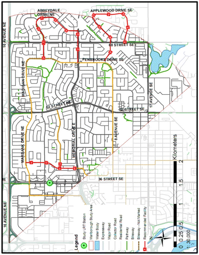
The research targets three suburban case study areas with LRT stations developed in the last 35 years when cycling has emerged as a priority in city-wide planning policies. The stations have been constructed at different phases of LRT development and illustrate the evolution of standards and normative requirements regarding the provision of bicycle facilities (routes and parking) at transit stations. Crowfoot station (2009), Canyon Meadows station (2001) and Marlborough station (1985) are on three different legs of the LRT network (Figure ).
Figure 2. Calgary’s LRT and case study areas.
Source: Adapted from City of Calgary (Citation2008).
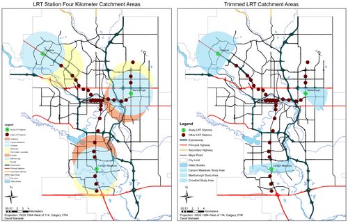
The spatial analysis is based upon a method of Inouye and Berry (Citation2008) who use a network analysis approach to create walk zones mapping pathways, sidewalks and roadways as possible routes between a starting point and a destination point. The outcome is a non-uniform shaped analysis zone where everything within the zone is within a specified distance from the destination taking into account one of the suitable routes. Our spatial analysis uses LRT catchment areas with a radius of 4 km (a suitable distance for a 10 min trip by bicycle at moderate speed) around the three LRT stations.Footnote6 The area within this 4 km radius is referred to as a transit cycling zone (TCZ) identified in Figure .Footnote7 The bicycle network analysis is conducted using ESRI’s Arc GIS 9.3. Data are collected from the University of Calgary’s MADGIC centre to map pathway and bicycle routes, LRT sites and Calgary community district boundaries. ArcGIS 9.3 maps show the roadway and pathway networks within each TCZ and a series of street nodes and street links to determine the overall connectivity index score for each area. Further, bicycle parking conditions at each of the three LRT stations are assessed. The level of bicycle facility provision in TCZ is determined on the basis of several benchmarks:
The longest contiguous bicycle facility;
The ratio of bicycle facilities to roadways;
The length of bicycle facilities per capita;
Bicycle parking facilities per capita & LRT users; and
Active modes connectivity index score.
Field observations and ground-truthing complement the GIS investigation. Since bicycle parking is an essential component of bicycle-transit integration, the quality and quantity of bicycle parking at each LRT station is examined.
Planning for the bicycle in Calgary
Historically different plans and policies impacted cycling in Calgary. In 1937, the idea of a bicycle path was first brought to City Council, yet it was not until 1946 that it became a reality. In the 1950s and 1960s, cycling was not a consideration in city planning. In fact, the only consideration was whether or not bicycles should be banned from major roadways (City of Calgary, Citation1996). Since the 1970s planning documents evolved from basic outlines of a bicycle network to comprehensive plans focused on a variety of issues affecting utilitarian and recreational cycling.
A chronology of major planning policies is presented in Table . Bicycle planning started in earnest in 1972 with the idea of creating a route system consisting of bicycle paths and bikeways. Over time the focus has shifted away from building a route system to optimizing it. The development of new bicycle routes in the last two decades became less important and other bicycle issues, such as safety, facility design, and enforcement of standards, bicycle parking and eventually integration with public transit increased. Planning policies became more specific since the 1980s moving away from broad recommendations, such as create a city-wide system of interconnecting routes, to specific targets and priority investments in the 1990s, followed by normative requirements affecting bicycle parking in the Land Use Bylaw 1P2007.
Table 2. Bicycle planning in Calgary: chronology of major planning documents.
Planning policy shift
The initial plans in Calgary focused on recreational users, while in the 1990s plans started to accommodate utilitarian users. The bicycle became part of The City’s overall transportation strategy and the 2008 Bicycle Policy and Needs Report identified a series of measures to enhance cycling facilities. The integration of bicycles and public transit, although first mentioned in 1984, did not achieve any prominence until the 1996 Calgary Cycle Plan. In this document, improving access to transit stops by bicycle, providing bicycle parking at stations and allowing bicycles on-board transit vehicles were clearly articulated. These planning goals affected community plans, but in many cases the recommendations applied explicitly to newly developed transit stops and/or newly built communities as opposed to retrofits.
Key informant interviews suggest that several planning documents adopted since 2000 define the present policy framework for bicycle-transit integration. The Calgary Pathway & Bikeways Plan introduces standards for a regional pathway system (Class I). It provides a linear network for segregated non-motorized movement for recreational and utilitarian purposes. Elements of the system include open space pathways (in parks, open spaces and environmental reserves) and boulevard pathways (off-street). The plan specifies that a bikeways system in Calgary consists of on-street areas open to bicycle travel, which excludes very few roads in the city.Footnote8 Advantages of residential streets and collectors are related to the lower traffic volume and speed while primary collectors and major roads tend to be more direct. The plan describes two types of bikeways (Class II routes) – signed bicycle route with a wide kerb lane and marked bicycle lane. Wide kerb lanes are suitable for higher volume collector roads and major roads (bikeways have a kerb lane of 4.3–4.6 m wide), while marked bicycle lanes (1.2–1.5 m wide) are useful for medium-to-high volume collector roads and major roads. Class III (shared roadway) is also an option, where there is no bicycle lane, signage or stenciling.
The Transit Friendly Design Guide advances three new policy objectives relevant to bicycle-transit integration. These include: (1) promotion of integration with other transportation modes such as non-motorized vehicles; (2) optimization of bicycle access to the transit system; and (3) the provision of bicycle storage facilities at major transit nodes. Calgary Transportation Plan (2009) represents a shift towards more sustainable transportation with a focus on walking, cycling and public transit. The Active Modes Connectivity Index, presented in the Connectivity Handbook section of the plan, is a tool designed to improve implementation of bicycle facilities throughout the city. The document mandates minimum standards of connectivity in new developments as well as provides opportunities for retrofitting of existing communities to improve walking and cycling. The plan further explains typical levels of connectivity in different community street types (grid, modified grid and curvilinear) and requires greenfield communities to meet or exceed a score of 1.6.
Implementation process
The implementation of planning policies affecting the provision of bicycle facilities and their integration with public transit is a complex process that has become well institutionalized over time. Several business units at the City of Calgary have key responsibilities for the planning, approval, enforcement of standards and actual investment in bicycle facilities (bikeways, pathways and parking). The Parks business unit approaches pathway development from a recreational perspective. However, there is recognition that the commuter is part of the system and we do try to accommodate their needs where possible relative to intensity of use. During the development approval process, Parks ensures that standards and policies are upheld. “We are concerned with connectivity, not only within the community that we are reviewing the application for, but also connectivity to the larger system, the river valley system, the transit system and the adjacent communities” (Parker, Citation2010).
In terms of pathway connections to LRT stations (Class I facilities), there is a two-tiered approach. When new stations are being constructed, the need for access, pathways to and from the LRT is identified at the planning stage. In new developments with LRT alignment, planners require absolute pathway connectivity, while in the context of area redevelopment/retrofits missing links are identified and incremental investments might follow over time. Signed or marked bikeways (Class II facilities) are typically not developed until control of the community is passed over to The City. At this point, the roadway network is assessed to determine where potential on-road bicycle facilities could be placed. The City’s list of priority LRT stations with bicycle improvements includes only seven stations in major activity centres (Crowfoot, Rundle, Marlborough, Brentwood, University, Chinook and Anderson).
The Transportation Solutions branch of the Transportation Planning Department is responsible for the development of the bikeways network. It uses the guidelines set out in the Bicycle Policy and Needs Report (2008) and the Calgary Transportation Plan (2009) (Jensen, Citation2010). Both of these documents discuss bicycle-transit integration and state that the City must take measures to ensure this type of multi-modal journey is possible (City of Calgary, Citation2008, Citation2009). Transportation Solutions and Calgary Roads since 2006 were given a budget to implement on-street bicycle improvements and typically such projects have a two-year cycle. In the Transportation Approved Business Plans and Budget 2006–2009, funding was provided to Transportation Solutions for the planning of bicycle network improvements, while at the same time capital was provided to the Roads Department to implement those improvements.Footnote9 In the 2009–2011, Transportation Budget the expenditures on cycling infrastructure increased six times.Footnote10 While there is no public access to the allocations in the next budget cycle (2012–2015), we were able to confirm that comparable funding would be available. The Transportation Infrastructure Investment Program, created in 2009 as a 10 year investment plan, increased the funding for bicycle and pedestrian infrastructure to over $4.5 million per year.
However, City staff is required to prioritize the allocation of these funds as well as streamline projects to keep costs down. This has created a situation where newer LRT stations have well developed bicycle infrastructure while older stations are left behind. There is no monitoring or ex-post evaluation system related to implementation of planning policies affecting utilitarian cycling or bicycle-transit integration in The City of Calgary, a gap that this research is attempting to address.
Results: spatial analysis in case study areas
The spatial assessment examines the TCZs – areas up to 4 km away from Canyon Meadows, Crowfoot and Marlborough stations. Areas are trimmed down in size based on overlap between the stations’ 4 km radius and its neighbours. The analysis explores bicycle facilities (bikeways and pathways) in each area to determine the level of accessibility for cyclists using a GIS-based methodology of Inouye and Berry (Citation2008). Comparing accessibility, connectivity and levels of bicycle parking in the case study areas highlights the extent to which planning policies have influenced opportunities for utilitarian cycling and bicycle-transit integration. The comparative data are presented in Table . In addition to descriptive characteristics (area size, population density and LRT users), the data are organized in three thematic clusters: (1) bicycle facility characteristics, (2) bicycle parking characteristics and (3) select ratios for easy comparisons regarding levels of bicycle facilities provision per capita.
Table 3. Comparative spatial analysis data in case study areas.
The land use pattern of the case study areas consists of low-density residential developments with clusters of medium-density residential usually adjacent to small strips of commercial and direct control-zoned properties. The areas have local schools, parks and a relatively similar provision (length/km2 12–15) of roadways. The high number of residential and collector streets, typically wide enough and with slow traffic speeds, are available to the experienced cyclists, but do not necessarily provide the most direct travel routes, especially in curvilinear neighbourhoods dominating the three TCZ. The length of pathways/km2 is much higher in the Crowfoot area (1.9 vs. .7), but this excludes the provincial pathway system in Fish Creek Park, a major recreational destination integrated with the Canyon Meadows Golf Course. The total length of bicycle facilities/km2 is the highest in Canyon Meadows (3.02) and the lowest in Marlborough TCZ (1.68).
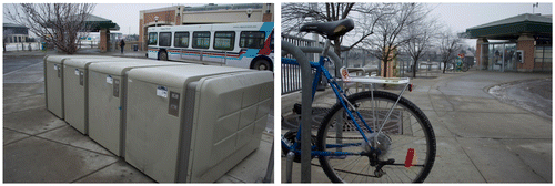
The Canyon Meadows TCZ has a mix of pathways and bikeways that likely meet the needs of different user groups (see Figure ). The pathways in Fish Creek Provincial Park provide limited access to the LRT station and are designed predominantly for recreational cyclists. The pathways within the community districts primarily link residences with school sites and the provincial park, targeting students using the bicycle for utilitarian purposes, recreational users and inexperienced cyclists, but do not connect to commercial districts and the LRT station, which limits the potential for inexperienced cyclists to use their bicycle for utilitarian purposes. The bikeways, however, provide linkages between communities and to potential utilitarian destinations such as shopping areas, particularly on the east side of the LRT station. The area includes 12.1 km of on-street bikeways in the eastern part of TCZ. There is much more opportunity for a cyclist to use a roadway than a bicycle facility, as for every 1 km of roadway there are .25 km of bicycle facilities (bikeways or pathway). The roadway layout has lower connectivity (index 1.33), which means that cyclists must travel relatively long, circuitous routes and/or use more direct collector roadways where the speed for motorists is higher and conditions for cyclists less safe.Footnote11 Additionally, there is a mix of secure and non-secure bicycle parking facilities at the station. The number of parking spots for bicycle is limited to 60 with a ratio of LRT users to bicycle parking of 67, the best in the sample (see Figure ).
Figure 3. Canyon Meadows TCZ.
Source: Adapted from Mahalek (Citation2011).
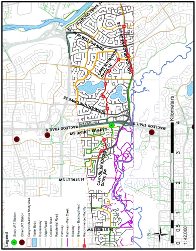
Figure 4. Bicycle parking at Canyon Meadows LRT station.
Source: Authors’ field work (2011).
The Crowfoot TCZ includes many elements that promote bicycle–public transit integration (see Figure ). It has a well-developed pathway system (the highest length/km2 of 1.98) that provides linkages to destinations in each community, such as shopping areas, schools and parks. As the facilities are segregated from motorized traffic they also provide a comfortable setting for inexperienced cyclists to ride to a variety of destinations. The two major bikeways that link Crowfoot LRT station are situated in Arbour Lake and Scenic Acres, providing the longest, most direct routes for cyclists (Figure ). The roadway network, however, has a curvilinear pattern with a connectivity score of 1.3 (lower than the required standard of 1.6). Cycling on the roads is circuitous and long. Despite the challenges for cycling using the roadway network, both pathways and bikeways provide intercommunity access as well as access to destinations within each community that can be utilized by cyclists of all types. Crowfoot LRT station has the highest number of Class I and Class II bicycle parking facilities with a ratio of LRT users to bicycle parking of 118.
Figure 5. Crowfoot TCZ.
Source: Adapted from Mahalek (Citation2011).
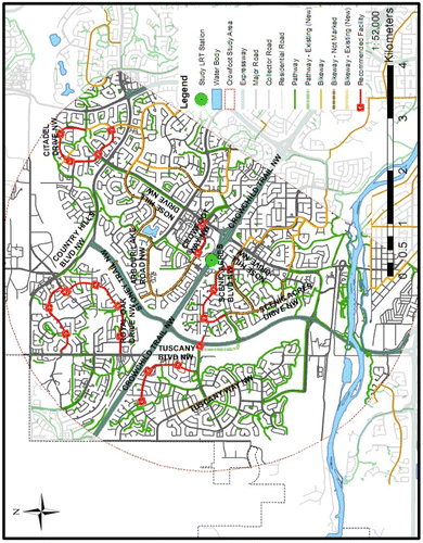
Figure 6. Pathways and bikeways in Crowfoot TCZ.
Source: Authors’ field work (2011).
The Marlborough TCZ has both strengths and weaknesses affecting bicycle–public transit integration (Figure ). The facilities in this area are not accessible to a wide variety of groups. The pathways in this region are few providing access to school sites (length of pathways /km2 is .9). The bikeways serve well major destinations, including the LRT station, in six of the eight communities in the area. The main bikeway (2.1 km long) provides relatively direct access to LRT, but is located on a busy street with some safety risks. The road network has a higher connectivity score (1.39) and is potentially a complement to the bikeway network. The bicycle parking at the Marlborough LRT station is limited; there are no secure bicycle parking facilities and just a few non-secure parking spots. Although the station has the highest LRT use, the bicycle parking situation may discourage users due to lack of security on site.
Figure 7. Marlborough TCZ.
Source: Adapted from Mahalek (Citation2011).
Conclusions and policy implications
The Marlborough and Canyon Meadows TCZs encompass communities developed for the most part in the 1960s and 1970s. The Crowfoot TCZ on the other hand is newer with most communities being established in the 1980s and the 1990s. In the newer communities, bicycle facilities are more developed with potential to facilitate bicycle-transit integration. Levels of accessibility to LRT stations demonstrated through several key metrics (bicycle facility to roadway ratio, bicycle facilities per capita and bicycle facilities to LRT user ratio) are considerably lower in older communities. The Canyon Meadows TCZ has a bicycle facility to roadway ratio of .13 (excluding Fish Creek Park), and length of bicycle facilities/km2 of 1.56. This ratio is similar to the Marlborough TCZ which has a bicycle/roadway ratio of .12 and a length/km2 of 1.68. The Crowfoot area, on the other hand, has a much higher bicycle facility to roadway ratio (.23) and length/km2 of 2.61. It appears that the newer the community, the higher the bicycle facility to roadway ratio and the more bicycle facilities per unit of land area. Newer communities also have longer contiguous pathways and/or bikeways. This corresponds to the shift in planning policies articulating the growing importance of bicycle planning and cycling as utilitarian and recreational pursuit.
The spatial analysis confirms that newer communities, such as those around the Crowfoot LRT, tend to have better developed commuter-oriented cycling networks compared to older ones. The potential for someone to make a multi-modal bicycle-transit journey is higher for Crowfoot and Canyon Meadows based on a much higher bicycle facilities to roadways ratio and bicycle facilities per capita. This is corroborated by insights from the focus group discussion with community association board members.Footnote12 The quality and quantity of bicycle parking facilities also seems to correlate to the period of development of LRT stations. The oldest station in the study, Marlborough (1985), has the worst bicycle parking conditions by a wide margin. Canyon Meadows (2002) performs well with 36 bicycle parking spots, one spot for every 67.5 users per day, with good lighting and site conditions. The newest station, Crowfoot (2009) performs better, suggesting greater influence of planning policies promoting bicycle-transit integration in the last decade.Footnote13
This research uses a straightforward, but relatively robust framework for analysis of opportunities for bicycle-transit integration. It has a number of quantitative indicators that can be useful in assessing the level of provision/accessibility and connectivity in TCZ. It is particularly helpful for a rapid needs assessment in older communities where investment in bicycle infrastructure and improvements around LRT stations are needed. Despite the fact that findings are limited to three case study areas, the research also highlights the importance of spatial aspects in the improvements of bicycle facilities. The current built form and planning implementation processes related to pathways and bikeways play a critical role in facilitating integration with public transit. There are advantages and disadvantages of both types of bicycle facilities, as there are specific opportunities for retrofits and provision of missing links in the most efficient manner. These opportunities are often contextually dependent (USDOT, Citation2009). The methodology of this research facilitates such decisions and a number of facility improvements are presented for each case study area in Figures , and .
In older communities, established prior to the planning policy shift towards utilitarian cycling, pathways are less prevalent and directed towards schools and parks, as Marlborough and Canyon Meadows study areas indicate. Although pathways are not necessarily the optimal facilities for utilitarian cyclists due to speed limit and multi-use nature, they provide relatively direct routes separated from automobile traffic. The interview data suggest that in older neighbourhoods pathways often do not provide linkages to destinations, but are used for recreational purposes. Retrofitting pathway systems in these communities is possible but would require land acquisition and/or repurposing City-owned land with considerable costs. In new communities, however, the pathway system is better developed, ensuring better linkages to community destinations and LRT.Footnote14 It might be feasible to extend it in key areas to improve connectivity at a moderate cost.
The challenges related to bikeways (Class II and III routes) can be abated through good design. It is possible to provide bicycle lanes on existing right of ways, capitalizing on the existing road system (Becker, Citation2005; Transport Canada, Citation2008). In established communities, roadways tend to have higher levels of connectivity (e.g. Marlborough), which means that they already provide relatively direct routes to destinations. In such cases, designated bicycle lanes have relative low cost of implementation and can be a preferred option (Parker, Citation2010).
The findings of the research indicate that the shift in planning policies in Calgary has a positive impact over the level of provision of bicycle infrastructure in suburban communities. It is essential that planners provide well-designed bicycle facilities (pathways, lanes and roadways) to increase bicycle use (see Pucher & Buehler, Citation2012b; Pucher et al., Citation2011). Our analytical framework is built on that premise, but it is not just about “If you build them, they will come”. The approach in this research advocates an emphasis on ex-post evaluation and monitoring by determining the accessibility and/or connectivity of facilities using key benchmarks and spatial analysis of routes. It relates key planning policies to desired outcomes and key indicators/metrics of performance. This may be used to determine what types of measures need to be implemented in practice at the community level to enhance utilitarian cycling and more sustainable travel behaviour.
Notes
1. Roadways in Calgary require a minimum right-of-way between 15.0 and 60.0 m depending on the type of roadway, while bicycle pathways and lanes are typically between 1.5 and 3.0 m wide. A parking stall for one bicycle takes up approximately 1 m2, while an automobile parking stall requires at least 13.5 m2 of land (City of Calgary, Citation2008).
2. Suburban areas in Calgary typically have low concentrations of employment, while the downtown has 138,500 jobs and 15,548 residents. So, a large part of the daily commute is from the suburban areas to the downtown and back at the end of the work day. Calgary’s monocentric job market has made the investment in public transit more efficient (City of Calgary, Citation2008).
3. In some cases, the construction or re-construction of an entire roadway may be required whereas in other cases providing lane striping and bicycle markings may be all that is necessary. In the 2006–2008 capital plan for the Vancouver Cycling Plan, the estimated cost of restriping 1.5 km of roadway with a bicycle lane was between CDN $5,000 and $10,000 and the cost of widening a roadway to accommodate a bicycle lane was $35 000–$150 000 per km (Becker, Citation2005).
4. Unfortunately, many aspects of roadway design do not consider the needs of cyclists, including shoulder width, on-street parking, lane width and signal detectors (Schimek, Citation1996). It is therefore important that planners integrate bicycles into the design of all facilities, particularly shared roadways.
5. Key questions in the focus group discussion targeted user input regarding bicycle facility improvements to enhance bicycle-transit commute and assessment of bicycle parking at LRT stations in the area.
6. In creating the LRT catchment areas, Inouye and Berry’s approach was simplified to establish analysis zones that are within a certain distance to the destination based upon straight line distance (as opposed to distance travelled on specified routes) which results in a circular-shaped study area.
7. In the event of overlap of catchment areas with a neighbouring LRT station, the size of catchment areas is trimmed to better reflect reality. This is based upon the assumption that a person will travel to the station that is closer to them. TCZs are trimmed at the midpoint between the study station and its neighbouring stations.
8. The City of Calgary Design Guidelines for Subdivision Servicing (2004) outline the different types of roadways in the city; residential, collector, primary collector, major and freeways/expressways; listed generally in order from lowest volume/travel speed to highest. Each of these roadways legally could be utilized by a cyclist; however, factors such as volume, speed and number of lanes play a role in a cyclists’ choice of where to ride.
9. Over $3.5 million is provided over the entire budget cycle for the Transportation Solutions branch. The Roads Department budget for bikeways implementation totals $1.5 million in the budget cycle, while the entire Roads Department budget is $111.7 million.
10. Calgary Roads committed a budget of $7.5 million during the three-year budget cycle to the Commuter Cycle Pathways programme.
11. This TCZ is characterized by two different situations for cyclists. Those living to the west are more likely to use Fish Creek Park pathways on their journey towards the LRT station, while those on the east of the station are more likely to use bikeways. A challenge on the east side is the lack of direct linkages between bikeways and the LRT station. A challenge on the west side is the relatively indirect nature of bicycle facilities that a cyclist would use to access the LRT station.
12. A board member in the Crowfoot study area stated that the situation for cyclists in their community was very good due to the proximity of the LRT station, the relatively wide residential streets, and a very good pathway network that runs through the community. A board member in the Canyon Meadows TCZ stated that despite the challenges resulting from lack of pathways that lead to major destinations, utilitarian cyclists have direct and convenient roadways to ride on.
13. The City of Calgary lacks normative requirements for the provision of parking facilities at LRT stations and the intervention is ad hoc.
14. Tuscany, established in 1994 in the Crowfoot area, has a well-developed pathway system that serves multiple destinations and is valued by its residents. Such examples can inform retrofit planning in older communities.
References
- Abraham, J. E., McMillan, S., Brownlee, A. T., & Hunt, J. D. (2002). Investigation of cycling sensitivities. Washington, DC: Transportation Research Board.
- Alta Planning + Design. (2005). Caltrans pedestrian and bicycle facilities technical reference guide: A technical reference and technology transfer synthesis for caltrans planners and engineers. Los Angeles, CA: California Department of Transportation.
- Aultman-Hall, L. (1997). Using GIS for evaluation of neighborhood pedestrian accessibility. Journal of Urban Planning and Development, 123, 10–17.10.1061/(ASCE)0733-9488(1997)123:1(10)
- Becker, J. (2005). Report to council – City of Vancouver cycling program (2006–2008) capital plan, cycling portion ( RTS 4777). Retrieved April 3, 2011, from http://vancouver.ca/ctyclerk/cclerk/20050118/tt3BAC.htm
- Brons, M., Givoni, M., & Rietveld, P. (2009). Access to train stations and its potential for increasing rail use. Transportation Research Part A, 43, 136–149.
- Berke, P., & Conroy, M. (2000). Are we planning for sustainable development? Journal of the American Planning Association, 66, 21–33.10.1080/01944360008976081
- City of Calgary. (1996). Calgary cycle plan. Calgary, City of Calgary: Transportation Department.
- City of Calgary. (2008). Bicycle policy and needs report. Calgary, City of Calgary: Transportation Department.
- City of Calgary. (2009). Calgary transportation plan (plan-it Calgary). Calgary, City of Calgary: Transportation Department.
- Dill, J., & Carr, T. (2003). Bicycle commuting and facilities in major US cities: If you build them, commuters will use them. Transportation Research Record, 1828, 116–123.10.3141/1828-14
- Ewing, R., & Cervero, R. (2001). Travel and the built environment: A synthesis. Transportation Research Record, 1780, 87–114.10.3141/1780-10
- Federal Transit Administration (FTA). (1999). Bicycles & transit; A partnership that works. Washington, DC: Author.
- Handy, S., & Xing, Y. (2011). Factors correlated with bicycle commuting: A study in six small US cities. International Journal of Sustainable Transportation, 5, 91–110. doi:10.1080/1556831090351478910.1080/15568310903514789
- Hansen, W. (1959). How accessibility shapes land use. Journal of the American Institute of Planners, 25, 73–76.10.1080/01944365908978307
- Hegger, R. (2007). Public transport and cycling: Living apart or together? Public Transport International, 2, 38–41.
- Heinen, E., van Wee, B., & Maat, K. (2010). Commuting by bicycle: An overview of the literature. Transport Reviews, 30, 59–96. doi:10.1080/0144164090318700110.1080/01441640903187001
- Hillman, M. (1997). The potential of non-motorised transport for promoting health. In R. Tolley (Ed.), The greening of urban transport (2nd ed., pp. 21–27). Chichester: Wiley & Sons.
- Hunt, J. D., & Abraham, J. E. (2007). Influences on bicycle use. Transportation, 34, 453–470.10.1007/s11116-006-9109-1
- Inouye, D., & Berry, K. (2008). Assessing bikeways networks around public schools: A tool for transportation planning in Washoe County, Nevada. Planning, Practice & Research, 23, 229–247.
- Jensen, N. (2010, February 16). Alternative transportation planner. Personal Interview. City of Calgary.
- Litman, T., Blair, R., Demopoulus, B., Eddy, N., Fritzel, A., Laidlaw, D., & Maddox, H. (2002). Bicycle planning – A guide to best practices. Victoria Policy and Transport Institute. Retrieved June 6, 2009, from www.vpti.org/nmtguide.doc
- Litman, T. (2007). Land use impacts on transport: How land use factors affect travel behavior. Victoria: Victoria Transport Institute.
- Martens, K. (2007). Promoting bicycle-and-ride: The Dutch experience. Transportation Research, 41, 326–338.
- Mahalek, D. (2011). Bycicle transit integration in Calgary. Calgary: Faculty of Environmental Design, University of Calgary.
- Nelson, A., & Allen, D. (1997). If you build them, commuters will use them: Association between bicycle facilities and bicycle commuting. Transportation Research Record, 1578, 79–83.10.3141/1578-10
- Parker, K. (2010, February 19). Leader, parks planning. Personal Interview. City of Calgary.
- Parkin, J., Wardman, M., & Page, M. (2008). Estimation of the determinants of bicycle mode share for the journey to work using census data. Transportation, 35, 93–109.
- Pucher, J., & Buehler, R. (2006). Sustainable transport in Canadian cities: Cycling trends and policies. Berkeley Planning Journal, 19, 97–123.
- Pucher, J., & Buehler, R. (2008). Making cycling irresistible: Lessons from The Netherlands, Denmark and Germany. Transport Reviews, 28, 495–528.10.1080/01441640701806612
- Pucher, J., & Buehler, R. (2012a). City cycling. Cambridge, MA: MIT Press.
- Pucher, J., & Buehler, R. (2012b). Cycling to work in 90 large American cities: New evidence on the role of bike paths and lanes. Transportation, 39, 409–432.
- Pucher, J., Buehler, R., & Seinen, M. (2011). Bicycling renaissance in North America? An update and re-assessment of cycling trends and policies.” Transportation Research A, 45, 451–475.
- Pucher, J., Dill, J., & Handy, S. (2009). Infrastructure, programs, and policies to increase bicycling: An international review. Preventative Medicine, 50, 106–125.
- Pucher, J., Komanoff, C., & Schimek, P. (1999). Bicycling renaissance in North America? Recent trends and alternative policies to promote bicycling. Transportation Research A, 33, 625–654.
- Replogle, M. (1992). Bicycle access to public transportation: Learning from abroad. Institute for Transportation Engineers Journal, 7, 19–21.
- Ryley, T. (2001). Translating cycling policy into cycling practice. World Transport Policy and Practice, 7, 38–43.
- Schimek, P. (1996). The dilemmas of bicycle planning. Presented at the Association of Collegiate Schools of Planning (ACSP) and Association of European Schools of Planning (AESOP) Joint International Congress, July 27, Toronto, Canada.
- Schneider, R. (2005). Integration of bicycles and transit: A synthesis of transit practice. Transit Cooperative Research Program (TRCP) Synthesis 62, Washington, DC: Transportation Research Board. Retrieved September 5, 2009, from http://gulliver.trb.org/publications/tcrp/trcp_syn_62.pdf
- Statistics Canada. (2013). Censuses of population 1996 to 2011, Tables 11a, 11b, 11c. Retrieved January 12, 2014, from http://www12.statcan.ca/census-recensement/2013/as-sa/97-561/tables-tableaux-notes-eng.cfm
- Talen, E. (1996). Do plans get implemented? A review of evaluation in planning. Journal of Planning Literature, 10, 248–259.10.1177/088541229601000302
- Transport Canada. (2008). Urban bicycle planning. Urban Transportation Showcase Program, Issue Paper 77. Ottawa: Author.
- Tolley, R. (1997). Obstacles to walking and cycling. In R. Tolley (Ed.), The greening of urban transport (2nd ed., pp. 3–21). Chichester: Wiley & Sons.
- Tsenkova, S., & Damiani, R. (2009). Urban sustainability: Learning from evaluation of community plans in Calgary. Canadian Journal of Urban Research, 18, 82–106.
- Velo Quebec. (1992). Technical handbook of bikeways design: Planning, design, implementation. Quebec: Author.
- Victoria Transport and Policy Institute (VTPI). (2009). Accessibility: Evaluating people’s to reach desired goods, services and activities. TDM Encyclopedia. Retrieved March 28, 2009, from http://www.vtpi.org/tdm/tdm84.htm
- USDOT. (2009). Lesson 18: Bicycle and pedestrian connections to transit. Washington, DC: Federal Highway Administration. Retrieved October 7, 2009, from http://www.tfhrc.gov/safety/pubs/05085/chapt18.htm
- Wardman, M., Tight, M., & Page, M. (2007). Factors influencing the propensity to cycle to work. Transportation Research Part A, 41, 339–350.
- Welleman, T. (1997). The Dutch bicycle master plan. In R. Tolley (Ed.), The greening of urban transport (2nd ed., pp. 177–190). Chichester: Wiley.