
Abstract
Since the 1990s, the population of Beijing has decentralized. This paper studies the relationship between residents’ commuting tools and their residential location during suburbanization by applying field survey data, statistical methods, and Geographic Information System techniques. The results show that public transportation is the most common choice for commuting. Residents commute the shortest distance do so by walking/bicycling and residents commute the longest distance do so by taking bus/subway. The likelihood of using bus/subway increases as the distance becomes longer; the likelihood of commuting by car/taxi has a very weak correlation with commuting distance. The results imply a public transportation-oriented suburbanization model in Beijing. By further mapping the subway lines and the geographic distribution of newly built houses from 2008 to 2012, it is discovered that public transit especially the subway plays a significant role in residential relocation in Beijing. This could explain the city sprawl in suburbanization in China.
1. Introduction
In Beijing, population migration from the central city to the outer areas has been going on for the past few decades. According to the description of population movement in the model of urban change by Peter Hall, Beijing has been in suburbanization since the 1990s (Zhou, Citation1996). However, population density is still very high in the central city. Moreover, the downtown area is becoming more prosperous than ever with more jobs and higher income residents. Meanwhile, the destinations of migration are not suburbs, but the new districts which are adjacent to downtown and are actually expansion areas of the city center. Relocating in these areas, people still work, go shopping, and share the same basic infrastructure as they did in downtown. It is obvious that this form of expansion is very different from the suburbanization of many cities in rich countries. What factors determine the location of residential expansion in Beijing? When looking at the case of transportation-oriented suburbanization, which kind of transportation mode may play a significant role?
2. Literature review
A classical theory of suburbanization, adopted by transportation experts, insists that when streetcars (e.g. private car and taxi), commuter railroads, and finally the automobiles are created and become available, people use these fast transportation tools to commute between downtown and the suburbs. Initially, expensive transportation modes were utilized by people of higher income, thus creating income-stratified communities. The accepted model created by the experts is that higher income people are the first to settle in suburbs, and this was the primary process of suburbanization (Mieszkowski & Mills, Citation1993). It is generally accepted that although automobile was and is now a major force in suburbanization, the streetcar was the initial determinant of the commuter relocation because it was developed before the wide use of automobile. Streetcar-oriented relocation of residents from downtown has resulted in prospering suburbs and the declining downtown. This effect is generally accepted as true in most developed countries. Xie and Levinson (Citation2005) argued that the streetcar was a crucial determining factor of the distribution and development of suburban housing. They found that having access to streetcar lines within an 800 m (radius), allowed for the prediction of an increase in the residential density to a significant extent as happened in the twin cities of Minneapolis and St Paul. Travisi, Camagni, and Nijkamp (Citation2010) confirmed that the streetcar encourages city sprawl using the data of cities in Italy. An empirical study by Nathaniel (Citation2007) indicated that “one new highway passing through a central city reduces its population by about 18 percent.” The case in suburbs of Boston shows a correlation between the development of streetcar and suburbanization while similar processes took place in Minneapolis and St Paul. Lv’s (Citation2006) research in China’s case indicated that suburbanization is created with dramatic increase of private cars during past several decades. However, Lv’s study only discusses the relationship between suburbanization and increase of private cars without a detailed analysis of other commuting choices. Considering the fact that the numbers of residents in downtown and in suburbs are increasing simultaneously in Beijing, the influencing factors of suburbanization need to be carefully studied.
Suburbanization trends were amplified when rail systems started to operate in Europe and in the United States at the end of the nineteenth century (White, Citation2008). The railway catalyzed both the compactness and the expansion of cities (Levinson, Citation2008; Warner, Citation1970). When the automobile became more affordable and available, road construction increased rapidly. Garcia-López (Citation2012) investigated the effect of improvements of the transportation infrastructure on changes in location patterns of population in Barcelona, Spain, between 1991 and 2006 and, found that transportation improvements led to suburbanization. Empirical findings from Israel by Israel and Galit (Citation2010) suggested that rail transit accelerates suburbanization and counter urbanization. Among studies of East Asian cities, Loo and Chow (Citation2008) examined the relationship between urban expansion and travel behavior based on the case study of Hong Kong. They found that suburban commuters had longer commute distance and time because of the lack of regulation in the new growth suburban areas. However, most non-work-related trips are mainly within new growth areas. It indicated that other factors (e.g. transit related infrastructure) have effects on residential relocation. The proximity and quality of public transportation services are also important factors in transportation mode choice (Buehler, Citation2011; Vega & Reynolds-Feighan, Citation2009). Moreover, many countries now have policies to reduce private car travel distance and to favor the use of public transport, cycling, and walking. However, the factors which determine travel behavior are not fully understood, so that effective policies are insufficient (Dieleman, Dijst, & Burghouwt, Citation2002). It is necessary to find the influence of transit modes on relocation choices.
A large number of studies have discussed the impact of urban form on travel behavior (Cao, Mokhtarian, & Handy, Citation2009; Cervero & Day, Citation2008; Dieleman et al., Citation2002; Pan, Shen, & Zhang, Citation2009; Vega & Reynolds-Feighan, Citation2009). However, residential location choice and travel mode choice may be interconnected. Schwanen and Mokhtarian (Citation2005) found the joint choices of residential location and commute mode. It is necessary to test the impact of different transit mode choice on residential location. When the growth of the city and suburbanization are going on simultaneously, the reasons for each type of urban expansion may be quite different. In China, both heavy vehicle traffic and urban sprawl are problematic in mega cities. It is obvious that the impact of urban form on travel behavior cannot fully explain the situation. It is more of an issue about how transit behaviors affect urban form.
In particular, a mega city in rich countries is always surrounded by many sub-cities which indicate a metropolitan area with a poly centric model. New sub-centers are created during suburbanization. However, urban public transportation that can be used to link the central city and the new suburb is a little bit difficult to construct crossing cities boundaries. Hence, the private car is more common mode of transportation here. However, Beijing is a mono-centric city, where the city center and suburbs are within the same bigger administrative boundary. The roles of different transport modes on urban formation are typically significant for the mono-centric model.
The relationship between transportation mode choices and residential relocation is studied here by examining commuting distances and modes based on a field survey. The following sections will describe methodology, results, and explanation with the assumption of suburbanization. Data from the field survey and ArcGIS techniques will be used to prepare information about commuters who use different transit modes and their residential locations.
3. Beijing’s suburbanization and traffic
China has experiencing a rapid urbanization since its opening-up. With huge amount of people moving from countryside to cities, the land value and housing price has been increased dramatically in cities, which encourages a large number of residential development in the suburban area adjacent to the city. As a result, the suburbanization of Chinese cities is going on with the reform of land and housing market. However, population relocation from center to outer areas does not create sub-centers in suburbs, instead leading to a sprawl around the city such as Beijing. This indicates the different dynamics of suburbanization of Chinese cities from cities in western countries. Certainly, the dynamics include housing price services and facilities in the city and transportation facilities. The former two factors push poor people move away from the center due to big differences between center and outer areas, the latter one leads different migrations and use of different transportation modes. Zhao (Citation2011) discussed the negative effects of regulation–liberation of land development management on the travel behavior modification in Beijing. The use of private car would attract rich residents to relocate in suburbs just under the condition that suburbs provide similar facilities as urban areas; public transit helps people to live in farther area where house price is lower. When transportation modes are combined with urban–rural development gap and the housing price, as well as different groups of income levels, we can explain the mechanics of suburbanization by studying the roles of different transportation modes in residents’ relocation.
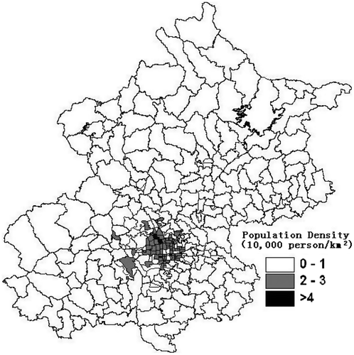
Urbanization and suburbanization are going on almost simultaneously in Beijing. Even population in suburbs has a rapid growth, the highest growth rates are in areas around the city instead of in conventional suburbs. Values of population density of areas right around the city center are much higher than those of suburbs that are farther from the city (see Figure for population density distribution around Beijing based on the 2010 Sixth National Census Data). This shows that Beijing is a typical mono-centric city. Migrating from the center to outer areas within this mono-centric structure leads to the situation in that the city is becoming bigger and bigger like urban sprawl other than the leap-frog growth.
Figure 1. Population density of Beijing at 2010.
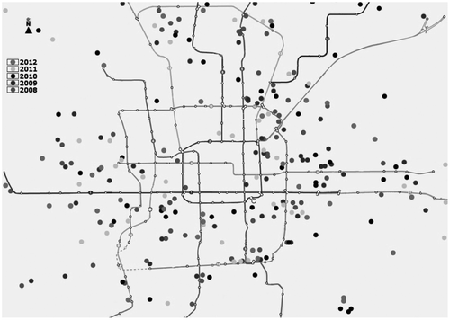
In the situation described above, the job density of central city of Beijing is 17,000 person/km2, with the highest value of 50,000 person/km2 in the Financial Street area in Xicheng District (one of the downtown areas in the city). Some areas near the central city have a high growth rate of 35.6% annually of newly built houses. It indicates the critical mismatch of job-housing in Beijing. A big volume of demand resulted from huge moving leads to heavy traffic for the city. The average daily commuting time for population in Beijing is 1.5 h; the average commuting distance is 19.3 km (Huang, Citation2011). Beijing is the city that has the longest commuting time in China. Kuang and Du (Citation2011) found that the effect of ring road on population distribution is more significant than other factors at district scale after they studied population distribution in Beijing. In Beijing, the construction of subway lines grow rapidly at a 25% annual growth rate, making subway the most important mode of transportation in Beijing. Agglomeration of new houses along subways also tells about residential relocation (see Figure for distribution of newly built houses from 2008 to 2012).Footnote1 The majority of the new development projects of housing after 2008 are found to be located near subway lines.
Figure 2. Newly built houses along railway lines during 2008–2012.
On the other hand, although public transit oriented policy has made Beijing the city which has the lowest prices for bus and subway among Chinese cities (it just cost a single ticket which is 2RMB for a person to take all the subway lines in the city except for airport which is accessible by rapid rail with higher price; The bus ticket just cost .4 RMB within 10 km of the city), more and more automobiles have lead to heavy traffic, as well as the intensive concentration of population in central Beijing. Therefore, although land use policy, housing market as well as transportation development are integrated with the suburbanization of population and industries, transportation development and the effect of transportation modes on residential relocation are crucial in suburbanization for a mono-centric city in China such as Beijing. However, present transportation data are mainly about the number of automobiles and traffic indicators (see Beijing Statistic Yearbook and Website of Beijing Transport Bureau). These data are not sufficient to explain the effects of different transportation facilities on commuting. Studies of job-housing balance and transportation’s effects on population distribution are mostly based on field surveys but without discussing the roles of accessible transportation modes (e.g. Huang, Citation2011; Song, Wang, Zhang, & Peng, Citation2007; Xu, Song, Fang, & Zhang, Citation2009; Zheng & Cao, Citation2009).
4. Methodology
4.1. Assumptions
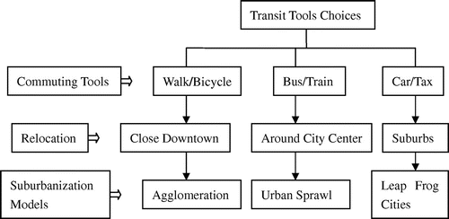
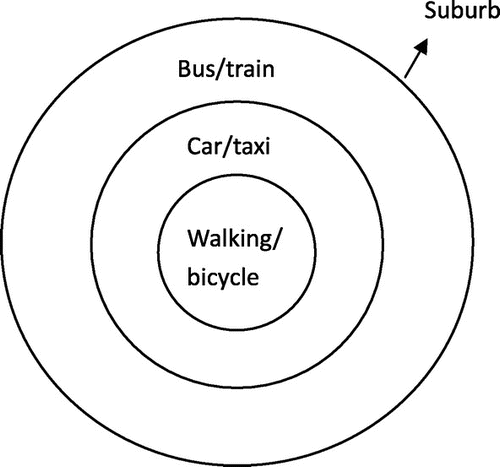
According to the mono-centric model, jobs and housing are concentrated in the central part of a city at primary stage of urbanization, just like Beijing described above. When transportation modes that have faster speed become available, residents in the suburbs use these fast modes to commute. Suburbanization starts with residential locations moved while jobs are still remained where they were initially. This results in a spatial mismatch between job and housing. The distance of mismatch indicates the different process of suburbanization. Zhao (Citation2011) examined the impact of the jobs-housing balance on individual commuting time in Beijing at the period of transformation of the city; the result shows that jobs-housing balance has a statistically significant association with a worker’s commuting time when the factors of transport accessibility are taken into consideration. Beijing’s suburbanization begins with the mono-centric model. During the suburbanization, the accessibility of commuting mode determines the location of housing given an automobile-driven mode. Three types of transportation modes are discussed here. Private car offers the highest accessibility to the furthest location of residence, followed by public transportation, and finally by walking or bicycle. Each type of transportation modes determines the residential location of population and then result in different suburbanization models (see Figure ).
Figure 3. Transit behaviors and suburbanization models.
It has long been a premise that automobile is taken as the significant determinant of suburbanization. However, in Beijing, we may see a new form of applying the automobile-driven mode to suburbanization, or even a non-automobile-driven mode. To determine what has actually happened, the nature of migration needs to be examined by survey. Therefore, a field survey with questionnaire is developed to obtain data about commuting modes, length of distance, and commuting time.
4.2. Data and geographic distribution of samples
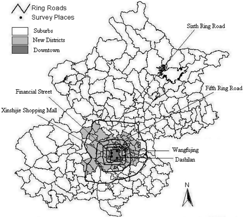
There are in total 18 sub-administrative units and four administrative districts in downtown Beijing before 2011 (the four downtown districts have been combined into two after 2011). Therefore, 14 districts or counties are suburbs of Beijing (e.g. since 1990s Haidian, Chaoyang, Fengtai, Shijingshan have been classified as inner suburbs, which are the potential central areas; six districts are suburbs within medium distance of the central city; four are outer suburbs). Field surveys were conducted in selected sites in all four districts. The four selected sites are: The Financial Street located in Xicheng District, Wangfujing located in Dongcheng District, Xinshijie Shopping Mall located in Chongwen District, and Dashilan of Qianmen located in Xuanwu District. The former two districts represent modern service areas, and the latter two are traditional commercial centers (see Figure ). The four districts were selected according to assumptions that decentralization starts initially from downtown during the primary stage of suburbanization and based on the mono-centric model of Beijing.
Figure 4. Survey sites.
The commuting distances from housing to job places, as obtained from the survey, identifies population relocation or migration. Therefore, the question about migrating distance can be explained by the trends of decentralization. Field survey was conducted in the middle of July 2007 before driving control (driving control policy has been operated since earlier 2008). Questionnaires were filled during 7:00–9:00 am, typical rush hour of commuting. A four-step methodology was adopted to do the survey. (1) The first step was pre-investigating. Investigators checked all the four sites and selected one main point for each survey site, crossroad corner of Fuchengmen North Street and Baiwanzhuang Street in Financial Street District; entrance of Pedestrian Street in Wangfujing; crossroad corner of Chongwenmen Inner Street and Western Chongwenmen Street in Xinshijie; north entrance of Qianmen Street in Dashilan. (2) The second step was selecting samples. Each sample was appointed every 4 min. Finally, 300 samples had been selected for each survey site to answer the questions. (3) The third step was using trained investigators to fill the questionnaires directly other than writing the sheets by respondents. The aim is to insure questions clearly understood by the respondents. (4) The fourth step was selecting qualified questionnaires according to background questions. The samples with Hukou identifications and their own houses were defined to be regular. Finally, the numbers of qualified samples are 253 for Financial Street, 254 for Wangfujing, 249 for Xinshijie, and 249 for Dashilan, a total of 1005 samples. The percentage of pass rate is 83.75%.
Geo-coding for addresses of the samples using ArcGIS software was used to integrate attributes and spatial data from the survey to get precise locations. Among 1005 questionnaires, there were 900 addresses matched with Beijing’s map. Finally, there were 900 valid samples remained for us to do spatial-statistical analysis with the following distributions: 231 samples in the Financial Street, 218 in Wangfujing, 232 in Xinshijie, and 219 in Dashilan. The rate of acceptability is 89.55%.
4.3. Spatial-statistic analysis
The spatial-statistic analysis took two steps. The first one was to classify distances with a natural break methodology. Break points between classes were defined using Junk’s optimization statistical formula, minimizing the sum of the variance within each of the classes. There were 20 breaks between distances classes, as well as groupings and patterns of each class of distance according to the 900 samples.
The second step was to calculate values of spatial statistic index for each of the 20 classes. The statistical function of ArcGIS provided the statistic values of minimum, maximum, count, sum, mean values, and standard deviation and values of all attributes of each class.
The spatial analysis provided both the average commuting distance and the number of commuters using each type of transportation mode. When the location distances were divided into 20 classes, the ratio of each type transit tool users to total one in each class indicates the likelihood of each type of transit mode being used. After getting the ratios and distances for each type of transit mode, we could do a correlation analysis of the ratios and distances to describe relationships between commuting distance and the likelihood of using different transportation modes.
5. Result analysis
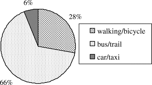
There are three types of transit tools for commuting that have been defined in this paper: walking/bicycles, bus/subway, and car/taxi, all of which have been included in the survey questionnaire.Footnote2 Among the 900 samples in the survey, the numbers of residents who use these three types of transit tools are as the following: 249 residents commute by walking/bicycle, or 27.7%; 597 residents commute by bus/subway, or 66.3%; Just 54 residents commute by car/taxi, only 6.0% of the total one (see Figure ). The result shows that public transportation is the most common choice of transportation mode for commuting for residents in the sample.
Figure 5. Ratios of three transit tools users.
Although public transit is the most common commuting mode choice, there is a question that needs to be explored, “if residents live farther than the majority of people in our study area, do they prefer to commute by car/taxi?” This needs to be examined further by comparing the sample distribution, number and ratio of car/taxi commuters to total commuters in different places and commute different distances. Using the data obtained from the questionnaires and the residential spatial distribution associated with three transportation modes, analysis can be carried out to answer this question.
5.1. Residents distribution by three types of transit modes
According to the different commuting distances of commuters who choose from the three types of transportation modes, it can be assumed that commuters would live in places that are in different distances from stops of their preferred transportation modes. However, the data show that walking/bicycle commuters live near the central city while residents who are using bus/subway tend to commute the longest distances, and those commute by car/taxi are distributed within small range of areas around downtown. This indicates that the car/taxi users commute only slightly longer distance than those on foot or riding bicycles and travel much shorter distance than public transit users (see Figure ).
Figure 6. Residential places by different transit tools.
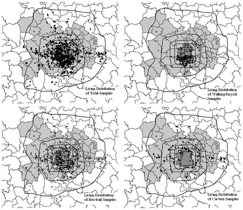
The result shows that average commuting distance for walking/bicycle commuters is 5.45 km, 9.05 km for bus/subway commuters, and 8.27 km for car/taxi commuters. The average distance of all sample commuters is 8.11 km. As expected, the samples of residents commuting by walking/bicycle locate at the nearest place to the central city. Surprisingly, residents commuting by car/taxi travel shorter distance than those by bus/subway.
After the commuting distances of different commuter groups being calculated by ArcGIS, the residential locations of three groups are presented by the three transportation modes and showed the following spatial distribution (see Table ).
Table 1. Distance of samples mismatch with three types of transit tools.
Table shows that most sample commuters live in areas around the downtown, which are actually the new districts of the city instead of suburbs. Nearly half of the sample commuters still live in the downtown, with somewhat fewer people relocating just outside the central city. Commuters who use walking/bicycle is the largest sample group and the group also tends to residentially located in the downtown. Compared to those who travel from outer areas (outside the Fifth Ring Road), the number of walking/bicycle commuters are still larger than that of car/taxi commuters. The number of commuters who take bus/subway also increases as distance becomes longer; it indicates that the residential location does not affect their transit mode choice. The number of commuters by car/taxi is found to be always the smallest. These people usually live around downtown other than somewhere far from the central city. This is quite different from what happened during the suburbanization in rich countries. Besides the numbers of different transit modes users in different areas, relationship between the commuting distance and the choice of three transit modes will show more details.
5.2. The relations between distances and three transit tools
According to the standard automobile-driven model of suburbanization, residents commuting by automobiles should have located at areas farther from the central city than those choosing other types of transit modes. However, the relationship between commuting distance and the number of commuters choosing different types of transportation modes, as well as the likelihood of choosing these types of modes provide some different evidences from the standard one.
The relationship between the commuting distance and the number of commuters choosing from the three transportation modes shows that commuters using walking/bicycles travel the shortest distance. Those using bus/subway commute the longest distance. And those commuting by car/taxi travel only slightly farther than those using walking/bicycles (see Figure ).
Figure 7. Relations between distances and numbers of three transit tools users.
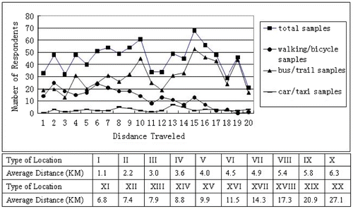
As shown in Figure , the number of commuters using walking/bicycle decreases as the commuting distance becoming longer while the number of commuters taking bus/subway increases as distance increases. However, the number of commuters taking car/taxi is always the smallest regardless of the commuting distance.
In order to show the relationship between the likelihood of choosing different transportation modes and the commuting distances, the ratio of each type of transit mode users to total number of users and the average distance in each distance category are compared, respectively. Higher ratio value indicates commuters more likely to choose this type of mode. The results are shown in Figure .
Figure 8. Relation between distances and possibilities to use three transit tools.
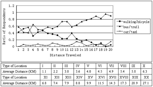
Figure shows that the ratio value of bus/train commuters increases obviously as distance becoming longer even at the longest level of distance. It indicates that bus/subway users tend to commute the longest distance averagely. While, the ratio value of car/taxi commuting number to total number of commuters shows not much change when the commuting distance increases. It indicates that private cars have no significant effect on residential relocation. The number of commuters who use walking/bicycles reduces as the commuting distance increases.
Further analysis of the relationship in form of correlation may provide statistical evidence for the relation in Figure . The formula is as following:(1)
where δxy is the coefficient, x represents the ratio of number of walking/bicycle users to the total number of commuters, y represents the average commuting distance of walking/bicycle commuters. This can also be applied to bus/subway, car/taxi samples, and their corresponding average commuting distances. Variables ux and uy are the average values of each pair of transit mode users (e.g. walking/bicycle, bus/subway, and car/taxi). There are 20 (the classifications number) series of data for each correlation analysis; this is indicated by n in the formula.
According to the result of correlation analysis, the coefficient of the ratio of walking/bicycle users and their average commuting distance is −.84, the one between the ratio of bus/train users and their average commuting distance is .84, and the coefficient between the ratio of car/taxi users and their average commuting distance is .43. These results show that the likelihood of walking/bicycling reduces significantly as the commuting distance increases. The likelihood of taking bus/subway increases substantially as the distance becomes longer. And the correlation of the likelihood of commuting by car/taxi has a very weak relation with commuting distance. The results cannot reach the conclusion of an automobile-driven suburbanization, and it implies a public transportation-oriented suburbanization model in Beijing.
6. Explanation
As showed above, spatial suburbanization influenced by the land use policy and housing marketing is followed by population urbanization in Beijing. In Beijing’s mono-centric model, poor people move first to outer areas because of the cheaper housing price; rich people prefer to stay at downtown due to better urban welfare in the central city than in outer areas even though they have private cars. On the contrary, poor people who have no cars either still live in less expensive places in downtown or move far away from the central city.
Besides the commuting data being used above, 34.5% of total population took bus/subway, and 32.6% took a car/taxi for travel including commuting and non-commuting) in Beijing in 2010 according to Transportation Bureau of Beijing. This implies that most people would travel by car/taxi for non-working trips. Non-commuting travels are not necessarily reflecting the relationship between residential relocation and work location. Hence, the private car is not primarily responsible for the relocation of residents and suburbanization model in Beijing.
Although both the urban and rural areas are under the same administrative authority’s management, there are big differences between the two areas in terms of social and economic situation. Living in urban areas means accessible to more welfare than living in rural areas. In Beijing, there are more public facilities and services provided in the central city, residents of higher income prefer to live around the downtown to access these advantages. Residential locations of different groups of residents in the samples in our field survey also show the different propensities to select transit modes and locations (see Table ).
Table 2. Distribution of transit mode usage by age, education, and occupation and commuting distances.
Among groups of residents as shown in Table , the white-collar, 30–45-aged and post-graduated residents are groups of higher income compared to the other groups. The percentage of car/taxi user in this higher income group is also higher than the other groups. Except that university/college and post graduated educated groups commute a little bit longer distance than the other educated groups do, white collar and residents in an older age cohort locate their house closer to the central city than blue collar and young residents. Therefore, the majority of residents with relatively lower income locate their houses where there is an access to public transportation. Therefore, there is a public transportation-oriented model for suburbanization in Beijing (see Figure ).
Figure 9. Suburbanization model of Beijing with different transit tools.
7. Conclusion
The evidences from this study have shown that in Beijing, the private car is not the determinant of suburbanization. Instead, it is public transportation that creates the accessibility for people to live far away from the central city. This public transportation driven pattern is different from situation in many developed countries. This finding suggest that even though new houses have been mostly built outside the central city, population is intensively distribute around the central city; although many residents with lower income relocate far away from the central city, there is still heavy traffic and commute demand in the central city.
These evidences support the findings of Cervero and Day (Citation2008) that moving near a suburban rail station significantly moderates the travel-consumption impacts of relocation, especially from the central city to the outskirts. With one side of the impact of urban form on travel behavior, this study contributes Schwanen and Mokhtarian (Citation2005)’s findings from Beijing’s case, on the other side this shows that improving public transportation policy may affect urbanization form.
In Beijing, public transportation infrastructure has been developed to serve mainly the central city in the mono-centric model. How far the transportation lines extend from the central city could determine the urban structure. Since the urban public transportation is mainly in the charge of local government, the interaction between the mode choice and transportation infrastructure accessibility impacts more on population density than the vice versa. When public infrastructure is constructed around the central city, the expansion of the city is unavoidable. This is the reason why the suburbanization of most cities in China is not like “leap-frog” but more like urban sprawl. The urban sprawl, which is characterized by lower densities, a low level of jobs-housing balance and a low level of public transport accessibility, would play a negative role in reducing car use and commuting times on the city fringe (Zhao, Citation2011). Therefore, we should pay attention to the role of public transportation development in influencing urban structure, more specifically, avoiding negative impact of leading to urban sprawl from the construction of subway lines. Meanwhile, the construction of rapid rail lines which linking the central city to outer suburbs may encourage a more comprehensive and independent development of outer suburbs in the future.
Funding
This work was supported by the Fundamental Research Funds for the Central Universities and the Research Funds of Renmin University of China [10XNJ007].
Notes
1. Information about the subway lines and houses are acquired from the official website of Beijing Subway (http://www.bjsubway.com) and property transaction column at the website of Beijing Municipal Commission of Housing and Urban–Rural Development, respectively. Dots in different colors represent houses that were approved by the administrative institution in different years.
2. Residents who combine bus/bus and car/taxi together are classified to bus/bus because they take car/taxi just for convenient transferring. The report by Huang (Citation2011) shows that more than 2/3 of commuters transfer 1–2 times one commuting way; particularly along new lines of bus/subway.
References
- Buehler, R. (2011). Determinants of transport mode choice: A comparison of Germany and the USA. Journal of Transport Geography, 19, 644–657.10.1016/j.jtrangeo.2010.07.005
- Cao, X., Mokhtarian, P. L., & Handy, S. L. (2009). Examining the impacts of residential self-selection on travel behaviour: A focus on empirical findings. Transport Reviews, 29, 359–395.10.1080/01441640802539195
- Cervero, R., & Day, J. (2008). Suburbanization and transit-oriented development in China. Transport Policy, 15, 315–323.10.1016/j.tranpol.2008.12.011
- Dieleman, F., Dijst, M., & Burghouwt, G. (2002). Urban form and travel behaviour: Micro-level household attributes and residential context. Urban Studies, 39, 507–527.10.1080/00420980220112801
- Garcia-López, M.-À. (2012). Urban spatial structure, suburbanization and transportation in Barcelona. Journal of Urban Economics, 72, 176–190.10.1016/j.jue.2012.05.003
- Huang, X. (2011). Urban and rural development report of Beijing (2010–2011) (pp. 23, 56). Beijing: Beijing Social Science Literature Press.
- Israel, E., & Galit, C. B. (2010). Testing the decentralization effects of rail systems: Empirical findings from Israel. Transportation Research Part A, 44, 523–536.
- Kuang, W., & Du, G. (2011). GIS study of population distribution in Beijing. Geographic Information Science Press, 13, 506–512.
- Levinson, D. (2008). Density and dispersion: The co-development of land-use and rail in London. Journal of Economic Geography, 8, 55–77.
- Loo, B. P. Y., & Chow, A. S. Y. (2008). Changing urban form in Hong Kong: What are the challenges on sustainable transportation? International Journal of Sustainable Transportation, 2, 177–193.10.1080/15568310701517331
- Lv, L. (2006). Suburbanization dynamics of mega city in China in new economic era, compared with suburbanization in U.S. Area Research and Development, 25, 6–10.
- Mieszkowski, P., & Mills, E. S. (1993). The causes of metropolitan suburbanization. Journal of Economic Perspectives, 7, 135–147.10.1257/jep.7.3.135
- Nathaniel, B. S. (2007). Suburbanization and transportation in the mono-centric model. Journal of Urban Economics, 62, 405–423.
- Pan, H., Shen, Q., & Zhang, M. (2009). Influence of urban form on travel behavior in four neighborhoods of Shanghai. Urban Studies, 46, 275–294.
- Schwanen, T., & Mokhtarian, P. L. (2005). What affects commute mode choice: Neighborhood physical structure or preferences toward neighborhoods? Journal of Transport Geography, 13, 83–99.10.1016/j.jtrangeo.2004.11.001
- Song, J., Wang, E., Zhang, W., & Peng, P. (2007). Mismatch of residential suburbanization and job distribution. Geographic Press, 4, 387–396.
- Travisi, C. M., Camagni, R., & Nijkamp, P. (2010). Impacts of urban sprawl and commuting: A modelling study for Italy. Journal of Transport Geography, 18, 382–392.10.1016/j.jtrangeo.2009.08.008
- Vega, A., & Reynolds-Feighan, A. (2009). A methodological framework for the study of residential location and travel-to-work mode choice under central and suburban employment destination patterns. Transport Research Part A, 43, 401–419.
- Warner, S. B. (1970). Streetcar suburbs. Cambridge, MA: Harvard University Press.
- White, K. J. C. (2008). Sending or receiving stations? The dual influence of railroads in early 20th-century Great Plains settlement. Population Research and Policy Review, 27, 89–115.10.1007/s11113-007-9056-3
- Xie, F., & Levinson, D. (2005). How streetcars shaped suburbanization: A Granger causality analysis of land use and transit in the Twin Cities. Technology and Culture, 46, 662–664.
- Xu, T., Song, J., Fang, C., & Zhang, N. (2009). Study on mismatch of living and job. Geographic Science, 4, 174–181.
- Zhao, P. (2011). Car use, commuting and urban form in a rapidly growing city: Evidence from Beijing. Transportation Planning and Technology, 34, 509–527.10.1080/03081060.2011.600049
- Zheng, S., & Cao, Y. (2009). Determinants and factors on relation between living and job. Urban Studies, 6, 29–34 (Chinese).
- Zhou, Y. (1996). Study on the suburbanization of Beijing. Geographic Science, 8, 198–205.