
Abstract
This research posits the question that good design of the bicycle infrastructure in a city will encourage more people to cycle. Research is carried out to compare the cycle infrastructure in selected European cities against an adapted Level of Service concept using accompanied ride-alongs. The literature review on the factors that encourage/dissuade cycle use suggests that it is the potential rider’s perceptions on the safety of cycling in their neighbourhood that is the deciding feature. Moreover, the literature review showed that contextual factors such as whether the actual infrastructure meets the needs of different cyclists are relatively under-researched. Six case study cities were selected (Edinburgh, Cambridge, Amsterdam, Rotterdam, The Hague, Utrecht) and compared on a range of factors by the riders including the coherence, directness, attractiveness, safety and comfort of the network. A cycle infrastructure scoring system was derived from the cycling research literature and the research was carried out by the researcher, an experienced cyclist, accompanied by an inexperienced cyclist. Using this research, the article makes several recommendations for improving and enhancing existing cycle infrastructure provision.
Introduction
Government bodies in the USA and Europe are sending strong messages to their citizens that physical activity, and in particular, cycling has positive personal and social effects (Cycling Scotland, Citation2013; Transport Scotland, Citation2011). This is a consequence of the growing understanding of the global (CO2 emissions) and local adverse effects (air quality, noise, physical intrusion) of motorised travel and the increasing levels of obesity in society. Government funding has been found for interventions that include awareness raising, personal support and skill training, subsidised equipment and city and workplace bike pool schemes. In many countries the cycling infrastructure has also been improved with segregated and shared tracks mainly catering for the leisure cyclist.
Only a few countries have, however, seen cycling as a means of making their cities more people friendly or as contributing to the green infrastructure in settlements. The Netherlands, Denmark and Germany are characterised, in this respect, as the leading countries in making cycling safe, comfortable and attractive by giving priority for cyclists including extensive bicycle parking, integration with public transport, education and promotion of cycling to a wide circle of recipients (Bertolini & le Clerq, Citation2003; Martins, Citation2004; Pucher & Buehler, Citation2008). At the same time, using a car has become more expensive, less comfortable and less necessary through the implementation of taxes and tangible restrictions associated with using a car. Spatial policies in these countries have, also, developed a compact building style offering mixed uses that reduce travel distance enhancing cycle accessibility. The success of these nations appears embedded in an integrated policy approach to promoting cycle accessibility for commuting, shopping and leisure purposes using car restrictive measures where necessary (Hull, Citation2010).
Government policy towards cycling and the cost of cycling stand out as the two main grouped factors of cycle usage in Rietveld and Daniel’s (Citation2004) conceptualisation of the take up of cycling. National, state and local policies which influence the quality and capacity of bicycle dedicated infrastructure, the spatial design and the pricing of private car use will impact on bicycle use. Whilst the perceived costs of cycling includes monetary costs, travel time, physical energy, risk of injury, risk of theft, comfort and personal security also influence bicycle use. There are several challenges in measuring the causal relationships between these variables. Quantitative cross-sectional research has shown a relationship between characteristics of the built environment, such as the availability of routes for cycling and patterns of cycling (Krizek & Johnson, Citation2006; Ogilvie et al., Citation2011; Parkin, Ryley, & Jones, Citation2007; Rietveld & Daniel, Citation2004) but the direction of the relationship is not clear. Statistical analysis of opinion surveys has focused on individual norms, attitudes and values towards cycling and shown how these vary by socio-demographic group (Department of Transport, Citation2012, Handy, Xing, & Buehler, Citation2010; Transport for London, Citation2010). Whilst Nankervis (Citation1999) studied the effect of weather on ridership, these studies do not readily encompass the influence of external factors in the physical environment. Studies that seek to evaluate complex infrastructural interventions often lack a robust study design and are criticised as exploratory (Chatterjee, Sherwin, & Jain, Citation2013; Ogilvie et al., Citation2011).
Qualitative research has focused on individuals to explore their thoughts and feelings about cycling using interviews, semi-structured questionnaires, focus groups and accompanied ride-alongs. The accessibility of the infrastructure and its connectivity are seen as important in some studies with the most important factors reported as travel time (Talihun, Levinson, & Krizek, Citation2007), safety (Scott, Citation2009; TfL, Citation2010), comfort (width of lanes) (Li, Wang, Liu, & Ragland, Citation2012), and visual interest (Fleming, Citation2012). van Duppen and Spierings (Citation2013) shared a ride with commuters to analyse their social and built environment experiences as they passed through different parts of the city. Lee and Moudon’s (Citation2008) questionnaire survey of the environmental barriers and the facilitating factors in cycling captured the safety, social environment, visual quality, and maintenance issues. The environmental barriers to cycling across all groups included too much traffic (42.0%), too many hills (30.5%), no bike lanes or bike trails (29.0%), no safe place to cycle nearby (20.5%), badly maintained streets such as rough surfaces (16.0%), distances to places too great (12.5%) and no interesting places to which to cycle (12.0%) (ibid: 401). Continuous bike lanes/ trails were the top facilitator across both active groups (74%) and inactive groups (77%). Other factors mentioned were, in order of importance, continuous bike lanes or bike trails, good lighting at night, bike racks at destinations, closer to interesting places to cycle other than parks and recreational facilities, closer to parks and recreational facilities, shower facilities at work, and more trees along streets.
The cycling infrastructure close to the origin of potential journeys and at the destination is, therefore, a key facilitator or potential barrier to encouraging cycling. Having introduced the topic in this first section, the article goes on to review the literature on the safety, or perceived safety, of the cycling infrastructure that has been provided in our cities. The factors identified in the literature review are used to construct a bicycle infrastructure score, which is explained in the third section and used in the research for this article. The article then goes on to compare the cycling infrastructure in six case study cities against the cycle infrastructure score system. The final section discusses the findings and makes recommendations on infrastructure design for policy implementation.
Perceptions of cycling safety
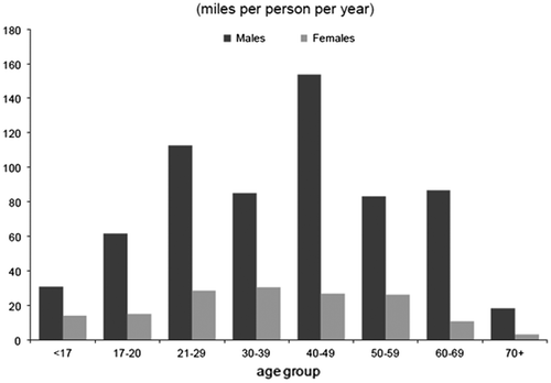
Most surveys show that the perceived traffic danger of cycling is an important deterrent to more widespread cycling (Cleland & Walton, Citation2004; Dill, Citation2009; Directorate-General for Public Transport, Citation2009; Snelson, Lawson, & Morris, Citation1993; TfL, Citation2010). Snelson, Lawson, and Morris (Citation1993) found that while people mostly didn’t cycle because they have a car, 11–17% felt it was too dangerous and 7–16% said that the amount of traffic put them off. In a study in Sydney reported in Cleland and Walton (Citation2004) a much higher 36% of women questioned said that lack of facilities was a reason they didn’t cycle and 32% said it was lack of on-road safety. Age and gender are factors in cycle ridership in the UK as shown in Figure .
Figure 1. Average distance travelled by bicycle in the UK, By Age and Gender.
Source: Department of Transport (Citation2013a) Table NTS0605. Used with the permission of HMSO.
Cyclists and potential cyclists have different levels of sensitivity to perceived conflict. Perception of conflict can be more important than actual conflict in determining whether people will use a route. There is a general trend towards decreasing bicycle fatalities in European countries, although there is anecdotal evidence of an increase of those seriously injured. Pucher and Buehler’s (Citation2008, p. 505) research uncovered that:
Averaged over the years 2002 to 2005, the number of bicyclist fatalities per 100 million km cycled was 5.8 in the USA and 3.6 in the UK, compared to 1.7 in Germany, 1.5 in Denmark, and 1.1 in the Netherlands.
The perceived possibility of accidents plays a significant factor in travel demand. Even a few incidences of accidents in one town will influence modal choice (Reitveld & Daniel, Citation2004). A study by Watchtel and Lewiston (Citation1994) of police accident records in California discovered vehicle collisions accounted for 85% of the bicycle accidents with the remaining accidents involving other cycles and pedestrians. Most collisions (74%) occurred at junctions, whilst the remainder were due to opening doors of parked cars and overtaking automobiles. Tesche et al. (Citation2012, p. 2340) found that cycle tracks had the lowest injury risk, with the next lowest risk shared by bike lanes on major streets with no parked cars and off-street bike paths. Route characteristics such as quiet streets (i.e., local streets) and no car parking on major streets were associated with low levels of injury risk. Other studies capture the benefits of segregated bicycle tracks/ lanes. Li et al. (Citation2012) found that separated bike lanes scored highly on comfort whereas on road lanes scored very low with the most negative features being: road condition, cars not leaving comfortable room, speed of vehicles and parked cars. The comfort level of the segregated group was 2.62 times higher than of the street group. Similar findings have been produced by Chen et al. (Citation2012), Reynolds, Harris, Teschke, Cripton, and Winters, (Citation2009), and Solomonov and Garcia (Citation2011), Research by Talihun et al., (Citation2007) indicates that cyclists are willing to pay the highest price for segregated bike lanes, closely followed by the absence of street car parking. The presence of kerbside parking can result in a loss of safety due to opening doors, cars pulling out and parking in the bike lane (Kang, Xiong, & Mannering, Citation2013).
Intersections, roundabouts and junctions are the main hazard for cyclists on cycle lanes (Dill, Citation2009; Soren, Citation2007; Watchtel & Lewiston, Citation1994). Junctions that are dangerous/ difficult to cross and lanes that suddenly stop (anywhere) are the weak spot in any cycle network and force the user to merge with motor traffic (Krizek & Roland, Citation2005). Junctions and roundabouts can be made safer if cyclists are given priority or have dedicated separate cycle tracks (CROW, Citation2007; James, Citation2012; Reynolds et al., Citation2009). Dutch roundabout design is comprised of a segregated orbital ring for cycling in which motorists must give way when entering and leaving the roundabout.
Safety, comfort, continuity and speed form the strongest drivers for the uptake of cycling and could influence new cyclists if barriers are tackled. Cycle paths are more beneficial where the lane is wide enough for overtaking; there are few intersections and discontinuities, where there is a detailed route layout with markings and good signage mixed with visibility of all cyclists and cars. The merits of the segregated cycle-lane are contested but there is no doubting the power of this lane in attracting new cyclists. From the literature it seems that it is the intersections and discontinuities that are the problem in terms of safety and flow.
Research methods
The key challenge in this research was how to operationalise the physical infrastructure attributes and characteristics of the built environment. The Level of Service concept is an American perception based technique, which was initially designed for motor vehicle infrastructure but has since been adapted for other modes of transport (National Transport Library, Citation1998), most notably for pedestrian movement (Atkins et al., Citation2012). The design factors chosen to audit the cycling network in the selected cities were adapted from the Netherlands Bicycle infrastructure design manual (CROW, Citation2007) the Bicycle Level of Service (Sustainable Cities Institute, Citationn.d.), Bicycle Stress Level (National Transport Library, Citation1998) and Bendiks and Degros (Citation2013) 5 + 3 Method. This research on cyclist’s needs highlight five requirements for a properly designed cycle network. These are the coherence, directness, attractiveness, safety and comfort of the network. In addition, two further categories were added to capture the rider’s overall experience of the ride-along and their perception of how well the routes chosen linked to the facilities or opportunities in the city cyclists might want to access. The seven categories of design factors used to benchmark the selected cities are shown in Table . Each category was broken down to a set of relevant criteria to provide 50 audit criteria which were scored based on a sliding scale of 1–5 with five being the highest rating (see scoring for each city in the Appendix). The riders were asked to observe and reflect upon these criteria when riding the routes selected in each city (CROW, Citation2007; Dill & Gliebe, Citation2008; Ogilvie et al., Citation2011; Snizek, Nielson, & Skov-Peterseing, Citation2013; van Duppen & Spierings, Citation2013).
Table 1. Cycle categories used to evaluate the case study cycle-ways.
The bicycle infrastructure audit is a qualitative, subjective audit to capture the different user perceptions on the comfort, speed and safety of cycling infrastructure in the selected cities. Two UK cities (Edinburgh, Scotland; Cambridge, England) were chosen because they have the highest percentage of bicycle users in their respective countries. Their perceived quality of design was compared with four Dutch cities (The Hague, Rotterdam, Utrecht, Amsterdam) which all have high cycling rates (see Table ).
Table 2. Case study comparison of population and cycling data.
The bicycle cycling infrastructure audit was carried out between September 2013 and January 2014 by the researcher, who is an experienced cyclist accompanied by an infrequent cyclist to give a different perspective on the perceived quality of the physical infrastructure and the mental/ stress factors associated with the ride. By pairing an experienced cyclist with a novice, the limitation of considering one perspective and ability of cyclist is partially overcome. The cycle route in each city selected included the city centre, a suburb, a train station and an educational facility. A video of each route cycled was taken to provide the users’ view and provide visual examples of how the infrastructure was rated by the participants. These were included in the field notes to provide observational data on the route, and with notes on the built environment, were used to assist the analysis. The participants used the cycle infrastructure score system explained above and their findings were combined into a City Cycle Infrastructure Score (CCIS) for each city. The next section gives some context to each city and then goes onto to discuss the results to allow a city comparison and to make recommendations on the cycleway designs encountered by the participants.
Case study context
The design, accessibility and connectivity of the cycling infrastructure in a city will influence the perceived suitability of cycling as a transport mode of choice. Of importance, also, are how cycling fits into the local transport policy and vision and the city spatial structure. This section introduces the spatial and policy context in each city.
Edinburgh
Edinburgh is located on the east coast of central Scotland. A population of 495,360 covering an area of 264 km² and a density of 1828 per km² (CEC, Citation2011) means that Edinburgh is a compact city therefore ideal for short trips by either walking or cycling. The street structure is highly varied from the cobbled, tight, and winding streets of Edinburgh Old Town to the tarmac uniform streets of Edinburgh New Town as well as the many suburbs. Edinburgh’s cycling policy was rated as 4 out of 5 by the Scottish Government’s national assessment of local authority cycling policies in 2013 (Cycling Scotland, Citation2013). Until recently, these policies were rarely activated, but the latest political administration is committed to spending a fixed proportion (6%) of the transport budget on cycling. The Edinburgh Active Travel Action Plan ATAP sets out the target for cycle modal share of 10% by 2020 (CEC, Citation2010). This is an ambitious target considering the current modal share is 2%. However commuter modal share is 10% dwarfing all other Scottish regions (Scottish Government [SG], Citation2013). Edinburgh is aiming to be a cycle friendly city by making it possible to travel by bike anywhere in a safe and convenient manner.
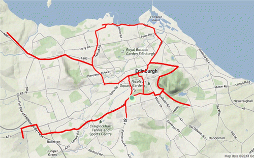
The selected cycle routes assessed are shown in Figure . Part of the route selected follows the National Cycle Network (NCN), which makes use of old railway lines and canals and is fairly connected passing through each side of the city via the city centre. The local authority routes are very disjointed. The route chosen starts at the South side of Edinburgh on the A702.
Figure 2. Route undertaken in Edinburgh Audit.
Source: Map Data@2013 Google.
Cambridge
Cambridge is located in England, around 50 miles north of London. With a population of 123,900 and covering an area of 115.65 km², a density of 1071 per km² (Cambridgeshire County Council [CC], Citation2011), Cambridge is fairly dense and flat, making it suitable for cycling. This is evident with the percentage of all journeys undertaken by bike at 18% with 29.9% being commuters (Office of National Statistics [ONS], Citation2011). Street structure is varied, the historic town centre providing a challenge due to limitations of space. The Cambridge Central Area Access Strategy states that it is necessary to restrict cycling at all times in the most densely used pedestrian streets but elsewhere to have safe and continuous links (CC, Citation2013a). Access to the city, however, is almost radial. Cambridge is one of Cycling England’s ‘Cycle Towns’. In 2008–2011 15 million US Dollars (11 million EUR) was invested to provide improved cycle routes and training and since 2011 has continued as part of a European funded project called ‘Bike Friendly Cities’ (CC, Citation2012). Cambridge Council’s vision is for cycling to be promoted as an attractive and practical alternative to driving and be an enjoyable, safe and healthy activity. Their key areas of focus are congestion, road safety, air quality and accessibility (CC, Citation2013b). To monitor progress the council has automatic cycle counters across the city to collect statistics on a daily basis. One policy impacting greatly on cyclists is that students aren’t allowed car parking permits. With a student population of around 43,000 (Laker, Citation2011) this policy is influential in encouraging other modes of travel.
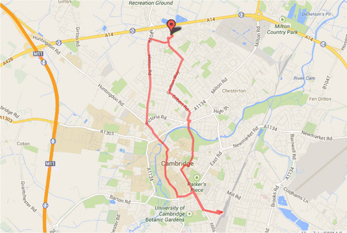
Figure shows the route taken in Cambridge starting in the suburb of Orchid Park following a trunk road into the centre. The route continues through one side of the centre to the train station and turns to navigate through the university quarter and the town centre, finally taking an alternate route back to Orchard Park. The route follows part of the NCN, which provides four points of access to the city, one from the south and three heading north at different tangents.
Figure 3. Route undertaken in Cambridge.
Source: Map Data@2014 Google.
The Netherlands
Cycling infrastructure design is very similar in the four Dutch cities selected, which are within 75 km of each other. Den Haag and Rotterdam are situated on the West coast. Utrecht is centrally located and Amsterdam sits north of the centre. All four cities are different in terms of their size, density, street structure and character. Den Haag is the parliamentary centre for the Netherlands offering a medieval core to the city surrounded by modern infrastructure. Rotterdam is an industrial city with a very busy port and many new striking developments. Utrecht is a medieval city still retaining many old buildings. Utrecht streets are thin and winding, with prominence given to pedestrian areas. Amsterdam, also a medieval city, has the largest population. Amsterdam’s streets consist of large avenues crossing all canals and small cobbled streets running between.
All authorities will stimulate walking and the use of the bicycle as the main means of transportation and as a link in the journey chain from door to door. Municipalities water boards, provinces and city areas will do this, amongst other things, by ensuring a bicycle network which complies with the main traffic requirements of cohesion, directness, attractiveness, safety and comfort. The authorities will also ensure parking facilities for cyclists which meet their demands in terms of quality, quantity and location. The Dutch Mobility Memorandum (Ministry of Transport, Public Works and Water Management, Citation2009, p. 34).
From the statement above we see that regional and local authorities are responsible for the majority of cycle infrastructure and facilities including the local cycle path network. Unusually, the regional water board also has responsibility of cycle infrastructure as many bike paths are alongside canals. The regional authorities are informed by:
Inrastructuur Verkeer en Vervoer (dIVV) (Transport and Infrastructure department).
Platform Feits (Cycle platform).
Dienst Ruimtelijke Ontwikkeling (Spatial Development Department).
Fietserbond (Cycling Association).
Fietsberaad (Cycle Consultancy) funded by the government and made up of members from each municipality.
These organisations inform Dutch policy and collate knowledge to inform the CROW design manual, to be applied in practice and provide regulation, guidelines, and recommendations. The policies between the four cities are remarkably similar despite decentralised policy from state to provinces and local areas. Increasing safety and promotion of bicycle use are the main objectives nationwide, with policy, coherence and continuity as their instrument (Directorate-General for Public Transport, Citation1999; Martins, Citation2006). Funding available from the government is around 46 US Dollars (34 EUR) per person per annum (Ministry of Transport, Public Works and Water Management, Citation2009).
Figures show the routes taken in the four Dutch cities.
Figure 4. Route undertaken in Den Haag.
Source: Map Data@2014 Google.
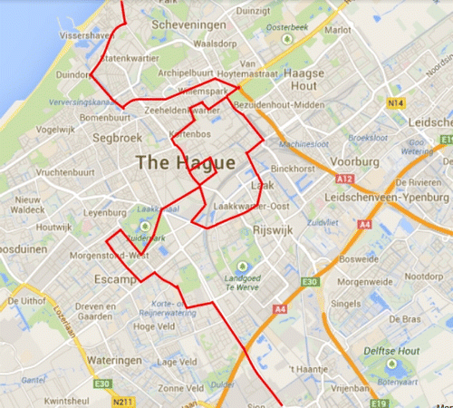
Figure 5. Route undertaken in Rotterdam.
Source: Map Data@2014 Google.
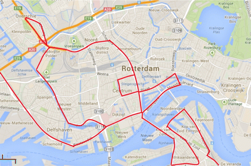
Figure 6. Route undertaken in Utrecht.
Source: Map Data@2014 Google.
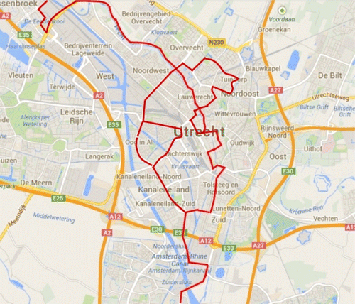
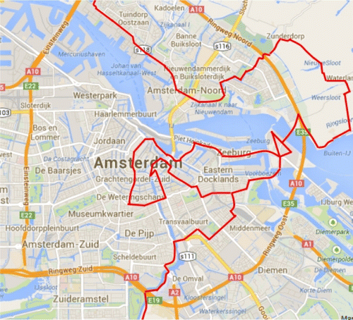
Figure 7. Route undertaken in Amsterdam.
Source: Map Data@2014 Google.
Bicycle infrastructure score findings
The design of the cycling network in the built environment of Edinburgh, Cambridge, Den Haag, Rotterdam and Amsterdam are here assessed to demonstrate how easy, direct, pleasant and interesting this sustainable mode of transportation has been made in the respective case study cities. In each of the cities there were two auditors, one an experienced cyclist and another who was a novice on-road cyclist. As explained earlier, the rating criteria used covered the consistency, directness, attractiveness, safety, comfort, spatial integration, experience and social economic value of the routes. All four Dutch cities are discussed together because infrastructure design is very similar in each.
The summarised results are shown in Figure and Table . The breakdown of results by city for each of the 50 criteria can be found in Appendices 1–6. As expected, a country with the reputation of the Netherlands scored highly in all categories. The combined CCIS for all four cities is 4.45. Utrecht scored the highest with Den Haag following closely. Despite being an historic city, Utrecht shows that it is possible to create good infrastructure in constrained space. Rotterdam achieved the lowest marks which is surprising considering that it is very modern and has the opportunity to implement measures to make roads safer and more attractive than the other Dutch cities; an overall score of 4.08 is still high. Cambridge scored a respectable 3.62 and Edinburgh scored the lowest at 2.51.
Figure 8. Spider web diagram comparing the Bicycle Infrastructure Scores.
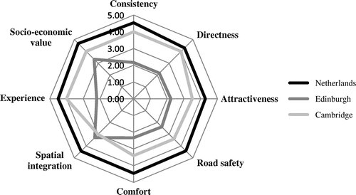
Table 3. Comparison of the bicycle infrastructure scores.
The six cities compared are varied in terms of demographics and density (Table ). In terms of area Cambridge, Utrecht and Den Haag are comparable, but population varies highly. Notably Table shows that higher densities do not translate to the percentage of people cycling. Den Haag has the highest density, but both Utrecht and Amsterdam have higher cycle use. This is the same for Cambridge, which is the least dense, yet has a favourable amount of people that use cycling as a means of transport.
The policies in the British cities are fairly similar with local active transport strategies in place alongside active local cycling groups. Despite similar aims, implementation of cycle infrastructure is highly variable being reliant on voter pressure. Cambridge has an excellent monitoring programme with automatic counters to provide the council with up to date and precise statistics. Another influential policy implemented by Cambridge is the restriction on parking permits for students. This might be harder to implement in other university cities in the UK, especially those with a more decentralised structure with key facilities (including the university) located around an outer ring road. The Dutch system has a more decentralised government system, with policy responsibility shared with the regional authority. The infrastructure is very similar due to the CROW design manual being used as best practice with another major factor being funding. Compared to British cities The Netherlands outperforms Edinburgh and Cambridge (Table ). UK local authorities do not have powers to raise their own funds either from their electorate or from private banks. They are funded to deliver central government policies.
Table 4. Governmental spend per person on cycling provision.
Consistency/continuity
After auditing it is apparent that the cycle infrastructure in the Dutch cities was the most consistent (Table ). There is continuity to the bicycle lanes making it easy to move around all four cities. Amsterdam was the weakest, mainly due to the urban fabric of short, narrow streets and junctions that provide many stopping points. This has, however, been ameliorated with bicycle priority lights at junctions. In Edinburgh and Cambridge the NCN has the most favourable infrastructure. The Cambridge local cycling network is highly regarded but the cycle lanes are continually interrupted where side streets intersect with main roads making the inexperienced cyclist wary of traffic approaching from the left. Many cycle lanes also end abruptly at major junctions with no instructions on how to proceed. Cycling infrastructure is not apparent in Edinburgh with cyclists sharing roads (predominantly two lanes) with automobiles and car parking on each side. The predominant cycle infrastructure in Edinburgh and Cambridge consists of an Advanced Stop Line for cyclists at traffic lights with the cyclist given their own bike box at the head of the queueing vehicles. This area was found to be frequently occupied by cars. Both cities had limited segregation. Edinburgh has made good use of disused train lines and Cambridge has segregation along the guided bus route. Many junctions and roundabouts are difficult as they have to be crossed in two sections and at times three.
Directness
Table shows that the Dutch cities scored the highest with Edinburgh at the bottom. Cambridge has scored well on this measure; while it had many discontinuities the routes were direct. The Dutch cities were signposted with destinations and distances, and routes were extremely easy to join. Where obstacles were presented such as large junctions, cycle infrastructure either bypassed it or cycle priority traffic lights were installed. Only one cycle priority traffic light was found in the UK study, in Cambridge. A major weakness in Edinburgh is the cycle speed calming. Barriers or gates are placed in needed locations to slow down cyclists on paths shared with pedestrians. Infrastructure in Edinburgh can be highly circuitous. To achieve the shortest routes many cyclists will use the busiest roads. Cyclists are not necessarily riding for leisure. To increase cycling, direct routes are needed to encourage other users, with good access to shopping, commuting and education. Not only are Dutch cycle lanes connected, they provide quick access to all land uses and also provide alternate leisure routes.
Attractiveness
The CCIS (Table ) has scored the Netherlands highly. This was due to attractive infrastructure that had a high degree of personal safety. Even at night in the suburbs the main routes were lit using high quality lighting. Parking was also of high quality and frequent. The suburbs close to Rotterdam Airport have a lot of heavy traffic and motorway overpasses, but cyclists can bypass these using underpasses. The public transport system allows cycles on all forms of public transport but only a certain number at a time, such as two cycles per carriage on a tram.
In Cambridge the conversion of car parking spaces into cycle parking was striking. This however needed to be more frequent as these were all full and many bikes were informally parked on railings. Edinburgh’s cycle issues were apparent with parking few and far between. The transport hubs had cycle parking, but insufficient for the demand. Cars parked in cycle lanes were a major issue in Edinburgh; Cambridge had some examples of this and impressively only two were observed in the Netherlands. The attractiveness of Edinburgh’s cycle-ways is mixed. Narrow bike lanes and streets with poor surface material, coupled with heavy traffic and parked cars in cycle lanes can easily dissuade cyclists. The National Cycling Network routes, however, are mainly off road and of better surface quality. Some of these routes, such as the Union canal, are used heavily for commuting but some parts are extremely narrow at 1 metre for two way traffic and pedestrians.
Road safety
Edinburgh has scored the lowest in this category. This is due to poor maintenance of cycle and car lanes. There are many potholes, some of which were extremely dangerous. The issue of parked car doors opening was also apparent in Edinburgh and Cambridge, less so for the latter due to some extra wide lanes and total segregation at points. In the Netherlands maintenance was extremely high and segregation led to the feeling of safety. Where cars are parked near cycle lanes there is adequate space to allow doors to open safely. Traffic speed and volume pose no problem due to the practice of segregating streets at different volumes and speed of cars. Due to speed restrictions and other speed reduction/calming measures, Cambridge feels safe for cyclists even when alongside automobiles. These measures also prevent fast overtaking and the high proportion of cyclists means that drivers are aware. Notably during the case studies most drivers were observant and patient in all cities and there were no altercations with them or pedestrians. The safety of cyclists at junctions in both Edinburgh and Cambridge could be improved with little guidance currently given to the approaching cyclist.
Comfort
Comfort goes hand in hand with safety. What was noticed was that the materials used by the Dutch were more resilient, and comfortable to cycle on. This material also offered little rolling resistance yet provided a high level of grip. This gave the Netherland the highest score (Table ). Den Haag did share tram tracks in the centre, however the rail is filled with soft rubber stoppers to prevent bike tyres getting caught. Intersections were also comfortable to navigate, providing clear indication where the bike should be. Roundabouts, with cycle infrastructure were a new experience for the auditors, with cars having to give way in and out of each road. Infrastructure both in Edinburgh and Cambridge showed signs of wear and little maintenance. Their infrastructure offered a bumpy ride. Cambridge provided more comfort than Edinburgh due to some wide lanes and automobile traffic calming measures. In Edinburgh, bikes can share bus lanes but this can be off-putting for new cyclists as the most vulnerable user is being merged with the largest road user. Parked cars in cycle lanes force cyclists out onto the road. As many as 35 parked cars were found in cycle lanes during the Edinburgh audit.
Spatial integration
All cities offered different urban fabrics. Nevertheless, the implementation of infrastructure in each can inform the others. Utrecht and Den Haag show that the historic fabric of a city can still be used to create a cycle (and pedestrian) friendly place. Amsterdam was the biggest challenge due to the shared narrow streets, especially with many tourists not used to the volume of cyclists. Wide avenues however did provide ample room to get from the centre in a radial format. Each city’s infrastructure complimented each area and allowed continuous freedom of movement. Rotterdam had the least greenery but the waterfront provided a tree lined bicycle highway and modern bridge leading to the south. Evidence of cultural identity is present in each city and in its surrounding areas. The problem in the United Kingdom seems to be that city centres in Britain still have the private car at the top of the transport hierarchy. Edinburgh has still scored the lowest (Table ), however it is the highest score Edinburgh has achieved through good implementation of the NCN sections. It still has a long way to go with many areas capable of supporting cycle infrastructure. Cambridge city centre had good infrastructure (even with discontinuities) in the centre because of the street density and structure, but this deteriorated towards the suburbs.
Experience
It is immediately obvious that in the Netherlands most people cycle as it is easy, quick and convenient. The auditors encountered people of all ages and gender easily identifying commuters, shoppers and leisure riders. This provided a welcome experience and a feeling of inclusiveness. Cambridge claimed its highest mark in this category even though the infrastructure was not as good as the Netherlands. This was due to a high amount of people cycling, some segregation and some wide lanes. The experience in Edinburgh had a dual nature. Experience was good in some parts (Meadows, Union Canal, & NCN route), but cycling in the city centre was highly intimidating especially when sharing with many cars, buses and a tram track.
Socio-economic value
Due to the connectivity of the cycling infrastructure with a variety of destinations and facilities, the audit shows that the Dutch provide best value to the public. All cyclists and destinations are catered for with end trip facilities at most locations. There are electric cycles charging points. Getting from A to B is a quick and pleasurable experience incorporating comfort and safety. The auditors also noticed training facilities for school children, showing that road and traffic awareness and infrastructure use is embedded at an early age. Cambridge also shows value despite a varied infrastructure as routes provide choice to the cyclist. This was apparent due to the many different types of cyclist and uses observed. Edinburgh has the lowest score with many cyclists being male and typically cycling for leisure/sport or hard-core commuter cyclists. In Edinburgh, the cycle infrastructure is connected to some extent, varying from good to minimal.
Conclusions
This research has used a detailed template to benchmark the Level of Service provided to cyclists in six European cities. The methodology has been tested using an experienced and a novice cyclist to capture their perceptions of the design of the cycle infrastructure in these cities. The literature review identified one of the barriers to encouraging more cycling is the potential/ inexperienced cyclist’s perception of the safety, comfort and continuity of the cycling network in their city. The ride-alongs have produced insights into how diverse urban landscapes are perceived by cyclists of different abilities. There are limitations with the research in that the audit was not carried out by sufficient numbers of riders of different abilities and different socio-economic characteristics to generate a greater understanding of their perceived issues. Five of the case studies were undertaken in the months of September and October, whilst the Cambridge audit was undertaken in the month of January. The weather, however, was fairly similar in all case studies therefore should not impact on the outcomes. Amsterdam may have been the anomaly through the number of visiting tourists creating a different experience of cycling through the city. While an effort was made to visit all land uses, the case studies never undertook a comprehensive study of all areas due to the limited time in each city and resources available.
Whilst each city is unique, many of them share the same transportation issues. The growth of car use and the subsequent perceived problem of congestion, particularly during peak hour travel cause financial loss and negatively effects residents who live in the central areas. City administrations have been given a responsibility to improve the health and well-being of their electorate, to enhance infrastructure investments and the spatial legibility of their urban structure, provide convenient transportation options within the city centre and to create an attractive structure of public spaces. Over-dependence on the car is very important from the standpoint of current economic development and urban transformation. One of the solutions to the connectivity and accessibility issues that affect the city, and particularly congested city centres, is to invest in a network of cycling infrastructure. Of the case studies assessed within this research, the Dutch have the most experience to share.
What comes out in this research is that the design of cycle infrastructure involves several spatial and behavioural factors. It requires strong government support to create priority for cyclists and to provide a safe, comfortable and attractive network that integrates with a spatial policy that encourages the concentration of spatial opportunities. The Dutch have followed a spatial policy promoting a compact building style offering mixed use that reduces travel distance, which can be easily made by bicycle. To be safe and convenient to use, government policy must, at least, treat cyclists on an equal footing to car users, public transport users, and walkers. If the spatial policy can make the car less necessary and convenient to use, government financial policy can reinforce this through car taxation and tangible restrictions associated with owning a car and using it. They could change the legal system so that there is an insurance bias to protect vulnerable road users. At the local level, promotion of cycling must involve more than physical infrastructure, it must integrate across policy delivery areas including spatial planning, transport, health and education.
With a supporting institutional structure pursuing agreed goals, as discussed above, the design of cycle infrastructure can have a big impact on choice. The strongest factors were safety, comfort and continuity. These will have to be at the forefront of design, which will need to be flexible enough to plan for any changes in cyclist’s needs through using a palette of policy solutions. UK cities are starting to reduce the speed of motorised traffic, and/ or reduce the space for cars, in their cities. Funding is being found for new cycle lanes. This research has shown that these need to be wide to ensure that cyclists can overtake and are not obstructed by car doors opening. Burchfield (Citation2009) and CROW (Citation2009) both recommend a minimum width of five feet and eight feet for new sections of cycle-way. The Edinburgh and Cambridge case studies also highlight the importance of the consistency and continuity of the bicycle network to ensure that there are no discontinuities and difficulties at junctions. Dutch roundabout design which incorporates cycle lanes on roundabouts increases the visibility of the cyclist and moves conflict with other users away from the junction, without impeding queueing traffic (CROW, Citation2007; James Citation2012). Cyclist confidence and participation may be higher where cycle routes are segregated from other modes of transport, but there is still the issue of discontinuous cycle lanes at junctions where the risk of conflict will be present. The case studies also highlighted the necessity of continually upgrading and maintaining the cycle infrastructure, particularly the surface material, which effects perceptions of comfort and safety.
To conclude, this research has found that cycle infrastructure design can encourage more cycling. It is recommended that when designing cycle infrastructure the following should be considered:
Wide cycle lanes.
Direct routes connecting all land uses.
Segregation where possible, especially on trunk roads and busy centre roads. Segregation does not have to be expensive. Bollards/vegetation can offer segregation through provision of a visual deterrent from driving and parking in cycle lanes. Adoption of the Dutch guidelines for cycle infrastructure.
Clear signage. Include signage in order to join a cycle lane.
No discontinuities of cycle lanes at hazardous locations (Junctions and roundabouts).
For intersections implement either a system to bypass the danger or provide bicycle priority traffic lights.
Use of high quality material for cycle lanes can offer comfort and reduce maintenance.
Speed barriers that are visible (night) and do not make the cyclist dismount.
High quality lighting on darker cycle lanes.
Attractive settings, e.g. Greenery and place making.
Frequent and high quality bicycle parking, not just at transport hubs.
Design of end of route facilities to be discussed with business and employers. (showers, bike storage).
Funding needs to be forthcoming, otherwise good quality infrastructure cannot be implemented.
Don’t implement cycle infrastructure as an add-on. Consider when designing all transport mode networks.
Other recommendations that are not included in design of cycle infrastructure, but have been noted in the case studies:
Regular maintenance of roads.
Enforcement (Cars and Cyclists) i.e. cars parking in cycle lanes, idling in Advanced Stop Lanes, dangerous overtaking of bicycles, cyclists running red lights (only noticed once during audit) and cycling on pedestrian only pavements.
Cycle training for all new drivers.
Continuing cycle training for schoolchildren.
Acknowledgements
We would like to acknowledge the work and support provide by the three novice riders – Euan McLaughlin, Kevin O’Holleran, and John Fern.
References
- Atkins, M. V. A., Phil Jones Associates, TRL. (2012). Shared use – operational review. London: Atkins.
- Bendiks, S., & Degros, A. (2013). Cycle infrastructure. Rotterdam: Nai010 Publishers.
- Bertolini, L., & le Clerq, F. (2003). Urban development without more mobility by car? Lessons from Amsterdam, a multimodal urban region Environment and Planning A, 35, 575–589.10.1068/a3592
- Burchfield, R. (2009). Cycle tracks: Lessons learned. Portland, ME: Alta Planning and Design.
- Cambridgeshire County Council. (2011). Cambridge City Annual demographic and socio-economic report April 2011, Cambridge: Author.
- Cambridgeshire County Council. (2012). County Council celebrates success as cycling levels rise. Retrieved March 14, 2014, from http://www.cambridgeshire.gov.uk/CMSWebsite/Apps/News/Details.aspx?ref=493
- Cambridgeshire County Council. (2013a). Cambridge central area access strategy. Retrieved March 14, 2014, from http://www.cambridgeshire.gov.uk/transport/strategies/transport-plans/cambridge_central_area_access_strategy.htm
- Cambridgeshire County Council. (2013b). Cycle policy and strategy. Retrieved March 14, 2014, from http://www.cambridgeshire.gov.uk/transport/around/cycling/Cyclepolicyand+strategy.htm
- Chatterjee, K., Sherwin, H., & Jain, J. (2013). Triggers for changes in cycling: The role of life events and modifications to the external environment. Journal of Transport Geography, 30, 183–193.10.1016/j.jtrangeo.2013.02.007
- City of Edinburgh Council. (2010). Active travel action plan. Edinburgh: Author.
- City of Edinburgh Council. (2011). Edinburgh by numbers. Edinburgh: Author.
- Chen, L., Chen, C., Srinivasan, R., McKnight, C., Ewing, R., & Roe, M. (2012). Evaluating the safety effects of bicycle lanes in New York City. American Journal of Public Health, 102, 1120–1127.10.2105/AJPH.2011.300319
- Cleland, B. S., & Walton, D. (2004). Why don’t people walk and cycle? (Central Laboratories Report No. 528007.00). Lower Hutt: Opus International Consultants Limited.
- CROW. (2007). Design manual for bicycle traffic. Amsterdam: Author.
- CROW. (2009). Design manual for bicycle traffic. Retrieved January 7, 2014, from http://www.crow.nl/publicaties/design-manual-for-bicycle-traffic
- Cycling Scotland. (2013). 2013 National assessment of local authority cycling policy. Glasgow: Author.
- Cyclist Touring Club. (2013). CTC welcomes Government progress on cycling but far more is needed. Retrieved March 13, 2014, from http://www.ctc.org.uk/news/ctc-welcomes-government-progress-on-cycling-but-far-more-still-needed
- Department for Transport. (2012). Shared use routes for pedestrians and cyclists. Local transport note 1/12. London: TSO.
- Department for Transport. (2013a). National travel survey 2010. London: TSO.
- Department for Transport. (2013b). Walking and cycling statistics. Retrieved August 12, 2013, from https://www.gov.uk/government/organisations/department-for-transport/series/walking-and-cycling-statistics
- Dill, J., & Gliebe, J. (2008). Understanding and measuring bicycling behaviour: A focus on travel time and route choice. Portland, ME: Oregon Transportation Research and Education Consortium.
- Dill, J. (2009). Bicycling for transportation and health: The role of infrastructure. Journal of Public Health Policy, 30, 95–110.10.1057/jphp.2008.56
- Directorate- General for Public Transport. (1999). The Dutch bicycle master plan. Den Haag: Ministry of Transport, public works and water management.
- Directorate- General for Public Transport (2009). Cycling in Netherlands. Den Haag: Ministry of Transport, public works and water management.
- van Duppen, J., & Spierings, B. (2013). Retracing trajectories: The embodied experience of cycling, urban sensescapes and the commute between ‘neighbourhood’ and ‘city’ in Utrecht, NL. Journal of Transport Geography, 30, 234–243.
- Fleming, S. (2012). Cycle space: Architecture & urban design in the age of the bicycle. Rotterdam: nai010 publishers.
- Handy, S., Xing, Y., & Buehler, T. (2010). Factors associated with bicycle ownership and use: A study of six small US cities. Transportation, 37, 967–985.10.1007/s11116-010-9269-x
- Hull, A. D. (2010). Transport matters. Integrated approaches for planning city-regions. London: Routledge.
- James, P. (2012). Roundabouts. Retrieved September 11, 2013, from http://pedestrianiselondon.tumblr.com/post/24151812132/roundabouts
- Kang, L., Xiong, Y., & Mannering, F. (2013). Statistical analysis of pedestrian perceptions of sidewalk level of service in the presence of bicycles. Transport Research Part A, 53, 10–21.
- Krizek, K. J., & Johnson, P. J. (2006). Proximity to trails and retail: Effects on urban cycling and walking. Journal of American Planning Association, 71, 33–42.
- Krizek, K., & Roland, R. (2005). What is at the end of the road? Understanding discontinuities of on street bicycle lanes in urban settings. Transport Research Part D, 10, 55–68.
- Laker, L. (2011). What makes Cambridge a model cycling city? Retrieved February 15, 2014, from http://www.theguardian.com/environment/bike-blog/2011/aug/17/cambridge-model-cycling-city
- Lee, C., & Moudon, A. V. (2008). Neighbourhood design and physical activity. Building Research and Information, 36, 395–411.10.1080/09613210802045547
- Li, Z., Wang, W., Liu, P., & Ragland, D. (2012). Physical environments influencing bicyclists’ perception of comfort on separated and on street bicycle facilities. Transport Research Part D, 17, 256–261.
- Martins, K. (2004). The bicycle as a feedering mode: Experiences from three European countries. Transport Research Part D, 9, 281–294.
- Martins, K. (2006). Promoting bike and ride: The Dutch experience. Transport Research Part A, 41, 326–338.
- Ministry of Transport, Public Works and Water Management. (2009). Cycling in the Netherlands. Den Haag: Municipality of The Hague.
- Nankervis, M. (1999). The effect of weather and climate on bicycle commuting. Transport Research Part A, 33, 417–431.
- National Transport Library. (1998). Development of the bicycle compatibility index: A level of service concept, final report, National Transportation Library. Retrieved August 26, 2013, from http://ntl.bts.gov/DOCS/98072/ch01/ch01_02.html
- Office of National Statistics. (2011). 2011 Census analysis – Method of travel to work in England and Wales report. Retrieved February 8, 2014, from http://www.ons.gov.uk/ons/rel/census/2011-census-analysis/method-of-travel-to-work-in-england-and-wales/art-method-of-travel-to-work.html#tab-Method-of-travel-to-work-across-local-authorities
- Ogilvie, D., Bull, F., Powell, J., Cooper, A., Brand, C., Mutrie, N., Preston, J., & Rutter, H. (2011). An applied ecological framework for evaluating infrastructure to promote walking and cycling: The iConnect study. American Journal of Public Health, 101, 473–481.
- Parkin, J., Ryley, T., & Jones, T. (2007). Barriers to cycling: An exploration of quantitative analyses. In D. Horton, P. Rosen, & P. Cox (Eds.), Cycling and society (pp. 67–82). Aldershot: Ashgate.
- Pedal on Parliament. (2014). Why £10 per head is not enough Retrieved March 13, 2014, from http://pedalonparliament.org/why-10-per-head-is-not-enough/
- Pucher, J., & Buehler, R. (2008). Making cycling irresistible: Lessons from the Netherlands. Denmark and Germany. Transport Reviews, 28, 495–528.
- Reynolds, C., Harris, A., Teschke, K., Cripton, P., & Winters, M. (2009). The Impact of transportation infrastructure on bicycle crashes: A review of the literature. Environmental Health, 8, 47–66.10.1186/1476-069X-8-47
- Rietveld, P., & Daniel, V. (2004). Determents for bicycle use: Do municipal policies matter? Transport Research Part A, 38, 531–550.
- Scott, C. (2009). Research into barriers to cycling in NSW. Sydney: AMR Interactive.
- Scottish Government (2013). Cycling action plan for Scotland. Edinburgh: Author.
- Snelson, A., Lawson, S. D., & Morris, B. (1993). Cycling Motorists – How to encourage them. Traffic Engineering and Control, 34, 555–559.
- Snizek, B., Nielson, T. A. S., & Skov-Peterseing, H. (2013). Mapping bicyclists’ experiences in Copenhagen. Journal of Transport Geography, 20, 227–233.10.1016/j.jtrangeo.2013.02.001
- S.Solmonow, & NGarcia. (2011). NYDOT press release. Retrieved August 18, 2013, from http://www.nyc.gov/html/dot/html/pr2011/pr11_102.shtml
- Soren, J. (2007). Bicycle tracks and lanes: A before – after study. Kongens Lyngsby: The Committee on Bicycle Transportation.
- Sustainable Cities Institute. (n.d.). BLOS/PLOS calculator form. Retrieved August 18, 2013, from http://www.sustainablecitiesinstitute.org/view/page.basic/frameset/feature.calculator/Calculator_Bicycle_Level_of_Service;jsessionid=BBE85CD51D47B43428B323C63BBC9804
- Talihun, N., Levinson, D., & Krizek, K. (2007). Trails, lanes, or traffic: Valuing bicycle facilities with an adaptive stated preference survey. Transport Research Part D, 41, 287–301.
- Tesche, K., Harris, A., Reynolds, C., Winters, M., Babulm, S., Chipman, M., Cusimano, M. D., Brubacher, J. R., Hunte, G., Friedman, S. M., Monro, M., Shen, H., Vernich, L., & Cripton, P. A. (2012). Route infrastructure and the risk of injuries to bicyclists: A case-crossover study. American Journal of Public Health, 102, 2336–2343.10.2105/AJPH.2012.300762
- Transport for London. (2010). Analysis of cycling potential, policy analysis research report December 2010, London: Author.
- Transport Scotland (2011). Cycling by design 2010. Glasgow: Author.
- van Duppen, J., & Spierings, B. (2013). Retracing trajectories: The embodied experience of cycling, urban sensescapes and the commute between ‘neighbourhood’ and ‘city’ in Utrecht, NL. Journal of Transport Geography, 30, 234–243.10.1016/j.jtrangeo.2013.02.006
- Wachtel, A., & Lewison, D. (1994). Risk factors for bicycle-motor vehicle collisions at intersections. ITE Journal, 64, 30–35.