
Abstract
This study aims at using spatial data to investigate and analyze the temporal spatial growth of the city of Dar es Salaam in Tanzania and quantify its relationship to transportation growth. The study will focus on the period from 1945 to 2012 and will use population and economic growth as parameters. The findings of this study show that there is a mutual relationship between Dar es Salaam’s urban growth, population, economy, and transportation. It found that transportation demand and infrastructure growth coincided with population growth; however, Dar es Salaam’s urban spatial expansion and residential area growth have been affected by transportation demand and infrastructure growth. It also found that enormous spatial expansion has caused dramatic changes in the daily share of travel modes and that these disparities have occurred in relation to urban growth and transport. Development initiatives and policies over time have not successfully solved this problem.
1. Introduction
In Global South countries, urbanization is a key driver of national economic growth. Continued growth requires innovative and complementary ways of applying funds and infrastructure to bring positive effects on private investment and living standards (UN-Habitat, Citation2013a). Some literature states that cities in sub-Saharan Africa are urbanized with little or no economic growth (Hsieh, Citation2014). This results in an increase of slums and informal settlements, which are difficult to provide with services and access to facilities (Augustijn-Beckers, Flacke, & Retsios, Citation2011; Vermeiren, Van Rompaey, Loopmans, Serwajja, & Mukwaya, Citation2012; Un-Habitat, Citation2013b, Citation2014). Most of the population of the world living in informal settlements is found in the in Global South (Oosterveer, Citation2009; Un-Habitat, Citation2010). Under the present scenario, informal settlements will continue to increase if mitigating measures are not taken.
There has been an unprecedented pace of rapid city growth mostly in the Global South caused by rapid population growth (Hsieh, Citation2014; Watson, Citation2009). Some literature shows that these drastic changes mostly take place in small- and medium-size cities in the Global South (World Bank, Citation2012). However, the growth has contributed to a rise in demand for social services and transportation (Gulyani, Bassett, & Talukda, Citation2014; World Bank, Citation2013). However, city and transportation planners have been working hard to solve this problem, but its intensity has remained a controversial issue (UN-Habitat, Citation2013b).
The objectives of this study are: to use spatial data to observe, quantify, and analyze spatial and temporal city growth in relation to population and economic growth of Dar es Salaam from 1945 to 2012, and to observe and analyze spatial and temporal growth of transportation demands and infrastructure in relation to population and economic growth from 1945 to 2012. It also intends to show the relationship between city spatial growth and spatial transportation growth, and finally to recommend viable measures to tackle the overriding problems around transportation and city growth.
The main sections that will be covered include: Section 2, literature review and background to the study which concentrates on the historical background, started by a general and then a specific approach. Section 3 includes materials and methods which outline data, materials methods, and the procedures carried out in order to arrive at the findings. Section 4 sets out the results of the research findings. And, Section 5 will cover discussion and final conclusions.
1.1. Study area
Dar es Salaam means “Haven of Peace” (Dari roof salama peace) in the Swahili language. The city was established by Sultan Majid of Muscat in 1857and later German colonialism was established, following the shift of its capital from Bagamoyo to Mzizima (the current Dar es Salaam). The following section introduces the study area and its basic details:
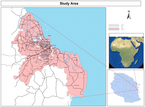
Dar es Salaam is located on the eastern side of the continent of Africa bordered by the Indian Ocean and islands of Zanzibar and Pemba to its east and northeast and to its south, north, and west it is hugged by the Coast Region. (Map ) Since independence, Dar es Salaam has been the major and dominant business and industrial center of Tanzania.
2. Context
2.1. Urban growth
The rate of urbanization has taken off at a remarkable rate around the world, and that speed has recently been widely witnessed in the developing world (Amer, Citation2007; Baffour Awuah, Hammonda, Lamond, & Booth Citation2014; Kombe & Kreibich, Citation2001; Vermeiren, Van Rompaey, et al., Citation2012; Mkurunzinza, Citation2013). There has been a high demographic growth in sub-Saharan Africa for several decades (Ogbazi, Citation2013; Diaz Olvera, Plat, & Pochet, Citation2008). Demographic growth has been on the rise in sub-Saharan Africa in recent decades with the trend appearing to continue. The continent’s population is projected to double to 2 billion over the next 40 years, and about 720 million people are expected to be living in urban areas in that time (Linard, Tatem, & Gilbert, Citation2013).
As opposed to Global North, urbanization in developing countries is primarily the outcome of demographic transitions, and economic factors and other considerations are secondary influences (Hsieh, Citation2014). What is clear in sub-Saharan Africa is the fact that cities are growing unmonitored and without due care for urban planning (Kombe, Citation2005; Lupala, Citation2002; Diaz Olvera, Plat, & Pochet, Citation2013). This trend outpaces infrastructure development leaving planners with the role of playing catch-up with past developments instead of planning for the future (Seto, Citation2011). This growth has brought positive impacts such as trade growth and negative impacts, including increased housing demand, shortage of services, a decline in living standards, land speculation, absence of urban waste management, and overcrowding (Kironde, Citation1997; Mbiba, Citation2014; Rizzo, Citation2014; Wubneh, Citation2013).
We will now focus on Dar es Salaam, the study area.
2.2. Urban growth in Dar es Salaam
The rate of urban growth in Dar es Salaam from 1990 to 2010 had an annual growth rate of 4.67% (Mkurunzinza, Citation2013) and was ranked the third fastest growing urban area in Africa (Hill & Lindner, Citation2010). Unlike in other cities in the developed world, where urbanization was the result of industrialization, urbanization in Dar es Salaam has been the outcome of population growth (Amer, Citation2007). Dar es Salam city residents use public transport (Daladala)Footnote1 and walking as the major means of mobility (Transport Policy, Citation2008) – also see (Figures and , Table ). During the German colonial era, the headquarters of the German East Africa Company was transferred from Bagamoyo to Mzizima (the current Dar es Salaam) because of its natural harbor (Halla, Citation2007), and this was the period when the Germans prepared and implemented the general planning scheme of 1891–1916. German colonization was followed by the British who introduced the second general planning scheme from 1949 (Halla, Citation2007). It was the British who introduced the concept of a master plan for the city center followed by institutional arrangements for professional practices which included the Land Ordinance of 1923, Town and Country Ordinance of 1956, Dares Salaam Municipal Ordinance of 1947, and the establishment of the Town Planning Department to be responsible for relevant tasks including the creation of a new master plan and other relevant issues.
Figure 1. (2014) Current mobility share mode in Dar es Salaam indicates that the split of mode share is dominated by public transport followed by walking. Cars are used by the least number of residents, but the trend changes with time (FIG 3) between 1979 and early 1980s, when a substantial number of residents resorted to walking as their major means of mobility.
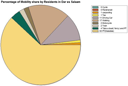
Figure 2. Mobility share mode in 1979: in 1979, the most popular means of mobility among residents of Dar es Salaam was walking; however, it changed with time to public transport.
Source: Dar es Salaam Master Plan (Citation1979, p. 50).
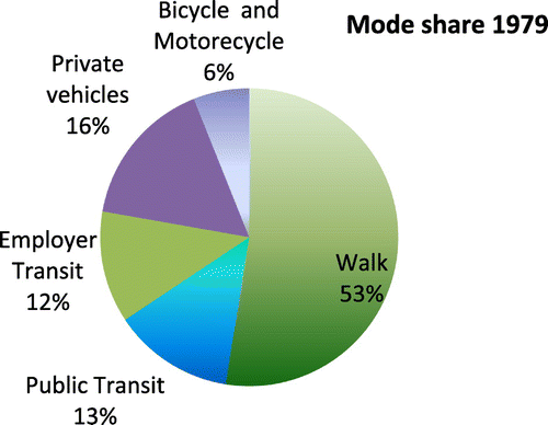
Table 1. Trend of changes in transportation demands and share mode from 1979–2014.
2.3. Transportation in Dar es Salaam
Transportation plays very important part in urban developments (Aljoufie, Zuidgeest, Brussel, & Maarseveen, Citation2013; Chissano & Minnery, Citation2014). Transportation plays a major role in urban development enabling movement of both people and goods between points. For Dar es Salaam, transportation is dominated by public transit and walking between its four primary roads and arterial roads (World Bank, Citation2011).
The history of public transport in Dar es Salaam can be traced back to 1967, when Tanzania adopted the Ujamaasocialist strategy for development and the country’s economic sectors were nationalized (Diaz Olvera, Plat, & Pochet, Citation2003b; Vermeiren, Van Rompaey, et al., Citation2012). In 1970, the Dar es Salaam Motor Transport System (DMT), the British monopoly company, was nationalized and split into Kampuniya Mabasiya Taifa (KAMATA),Footnote2 responsible for regional routes, and Usafiri Dar Es Salaam (UDA),Footnote3 operating and serving as Dar es Salaam public transport (Diaz Olvera, Plat, et al., Citation2003b; Vermeiren, Van Rompaey, et al., Citation2012, p. 136). UDA’s operation, however, declined with time from the very beginning (Table ) due to the economic crisis in the 1970s (Sohail, Maunder, & Miles, Citation2004). And then, privatization contributed to the huge importation of private vehicles from 2003 to 2013 (Table ). This was combined with an economic crisis so that government faced a difficult situation in providing services to major roads.
Table 2. Public buses under UDA.
Table 3. Imported buses from 2003 for government and private use (at Dar es Salaam Port).
2.4. Current transportation situation
Traveling for Dar es Salaam residents is influenced by behavior, proximity, and a mix of land use, density, and design. The city’s residents travel short distances but with much difficulty (Mkurunzinza, Citation2013; Diaz Olvera, Plat, & Pochet, Citation2003a), leading to low levels of mobility and therefore, difficulty in meeting transportation demands. Some literatures show that most of the urban poor cannot afford the fare officially set for private services providers (Diaz Olvera, Plat, et al., Citation2003b; Sohail, Maunder, et al., Citation2004).
The poor level of mobility is caused by overpopulation, poverty, and uncontrolled urban growth, factors that directly affect the provision of transport services and transportation infrastructure construction. Dar es Salaam is generally clustered and uses zoning systems with high-density residential areas; most of its residents regardless of where they live rely on public transport. In spite of this, residents who live on the fringes of the city use informal means of transport due to the fact that access to bus stops varies from place to place.
Normally, the waiting time at a bus stop is five minutes (this is not official since no public transport schedules exist); however, due to a shortage of buses, residents are forced to scramble when a bus pulls in, which means one would spend more time waiting for a decent opportunity to board a bus. It is because of this problem some middle-income earners tend to buy second-hand vehicles to meet their needs (Figure ). As a consequence of heavy congestion during peak hours, some residents resort to using motorcycles, thus increasing their demand and bringing their number to about 600,000 (Table ). Motorcycles account for about 50% of traffic on main roads during peak hours (Figures and , ).
Figure 3. Car use motivation showing people’s attitudes toward choice of using a particular kind of mobility.
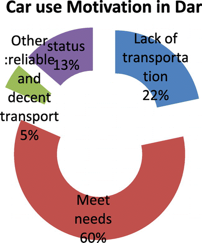
Table 4. Importation of motorcycles and rickshaws at Dar es Salaam port, where 70% of vehicles remain in the city and 30% are shipped to other regions.
Figure 4. Trend of population growth Dar es Salaam from 1948 to 2012.
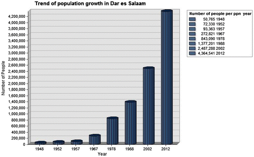
Figure 5. Dar es Salaam’s population growth in relation to other regions of Tanzania has been rising with considerable variation from 1988, and over – escalation increased in 1990s.
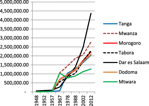
Figure 6. Population growth between the two major cities in east Africa, Dar es Salaam has the highest population growth with Kampala having the highest density.
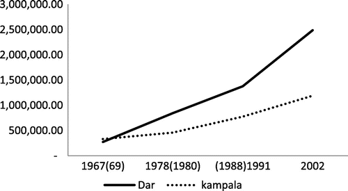
Figure 7. Dar es Salaam’s GDP growth in relation to other regions in Tanzanian Shillings from 1980, 1992–1995 data not available.
Source: Research data.
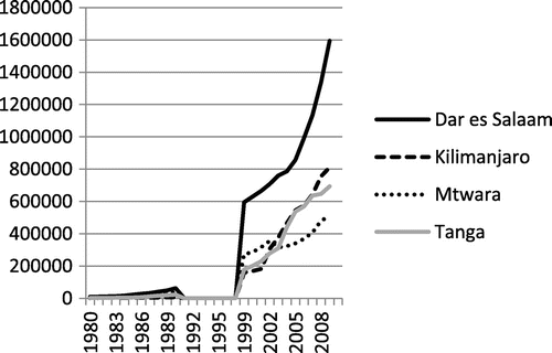
Figure 8. Population Growth in relation to urban growth.
Temporal growth of Dar es Salaam from 1945 to 2012 in relation to population, economic, transportation, and urban growth. Figure shows that the pace of population growth is higher than that of the economy and spatial growth during years of study. Figure shows a close relationship between road construction and urban growth during the same period.
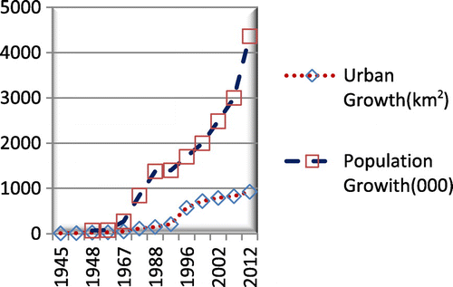
Figure 9. Relationship Between urban growth and road network expansion.
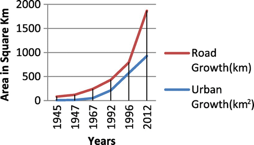
Figure 10. Simultaneous relationship between economic, spatial, and population growth from 1952 to 2012.
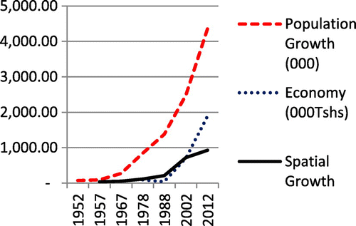
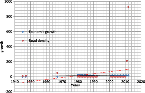
Figure 11. Linear correlation between transportation and economic growth: the graph shows the relationship between economic growth and road construction, where presently, demand for transport has increased simultaneously with road construction, with still not enough roads in the city.
Map 1. Location of the study area, the city of Dar es Salaam, located along the Indian Ocean coast of East Africa on the eastern edge of Tanzania.
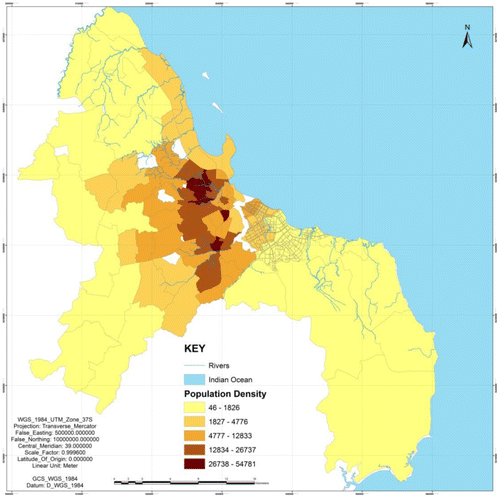
Map 2. Population Density in Dar es Salaam with high density around the city center, decreasing outwardly toward fringes.
The city lacks enough grid arterial roads (Map ), preventing an introduction of an effective public transport system that extends far into the urban fringes that would convince residents to rely on public transport. Other problems plaguing the city include parking space shortage, lack of pedestrian zones, and a high mixture of traffic in the city center (Ministry of lands, Citation2002).
Map 3. Public transport accessibility from the main roads indicating arterial roads when buffered with 1 km from the center to measure the convenience of public transport proximity and accessibility.

2.5. Income disparity
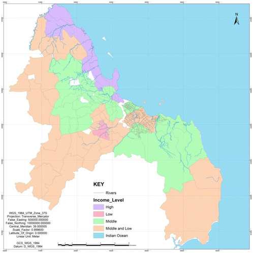
Income disparity is synonymous with the city’s geography and history. Today, most high-income earners live on plots close to the beach in suburbs like Mikocheni, Oyster Bay, and Mbezi Beach (Map ). The income bar drops proportionally as you move away from the sea front (this does not apply to the new city area around Kigamboni, Mjimwema, and Kibada). Historically, during German and consequently British colonization, some areas designated for low-density residences such as Masaki and Oyster Bay were specifically for Europeans (Lupala, Citation2002). Upanga and Kinondoni, which were medium-density suburbs, were for Asians who were middle-income earners. Kariakoo and Tandika with high population densities were for Africans who earned low incomes. The current detailed distribution of income disparity apart from colonialism is shown below.
Map 4. Income-level disparity in Dar es Salaam: the Maroon shade shows areas with high-income dwellers in the northeast section of the city, low-income areas are in the central part of the city in pink, middle- and low-income areas are mixed up in parts shown in brown, while middle-income areas are highlighted in green (light blue is the Indian Ocean and the area in white area is of scope).
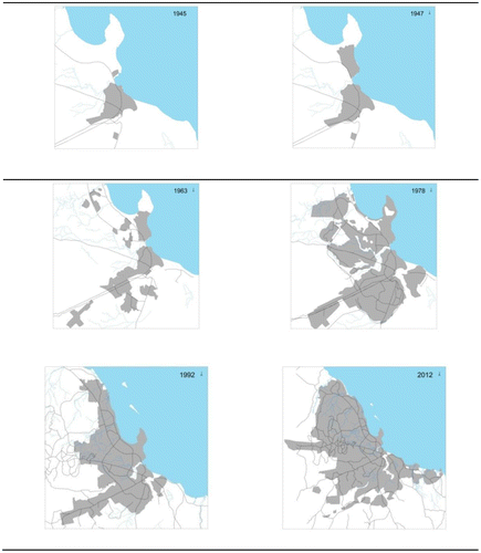
Map 5. Dar es Salaam Temporal spatial Growth.
Source: Master Plan (Citation1979), Master Plan (Citation2012).
3. Methods
3.1. Data
To conduct this research, different methods of collecting primary and secondary data were used. Secondary data collected include policies, master plans, shape files, satellites images, topographic sheets, aerial photographs, and relevant reports.
Primary data were gathered by way of a questionnaire sent or distributed to 654 respondents. Information gathered from the questionnaire aimed at providing information on mobility share mode, traveling time from home to a destination, waiting times at the bus stop, and attitudes of residents toward the use of public transport. Spatial data collected aimed at indicating the temporal changes that have been taking place in the study area, population distribution, services distribution, and transportation infrastructure. The data were then processed into an excel sheets for the purpose of analysis and findings. Other primary data were collected through interviews and direct observations.
Most of the data collected were in spatial data format, so there was a need to process the information by georeferencing to get them in the proper order. The researcher used projection called UTM WGS 84 Southern Hemisphere Zone 37 South, as it is suitable for Dar es Salaam.
Spatial data were also processed by creating two geodatabases of personal and file geodatabase created through Arch Catalog and all of the feature classes and raster data-sets were imported. A digitization process was conducted to create shape files and the required layers for study. The shape files created include urban growth 1945, 1947, 1963,1967,1978,1992, and 2012.
Other layers made include primary road network layers from 1945 to 2012, different layers, rivers, Indian Ocean, population density, income distribution, average distance to the city center, and some other layers of different uses.
3.2. Application of methods
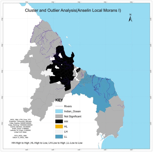
Data collected from the questionnaire were loaded into excel sheets and then simple calculations were made to get graphical results and tables. Some of the graphs were also made using ArcGIS software. Also, modeling and some prediction were done using ArcGIS. Mapping clusters were achieved using cluster outlier analysis (Anselin Local Moran’s I) (Map ). This was done to display the intensity of clustering in the city. Spatial relationships were indicated using ordinal least square (OLS).
Map 6. Population and city growth with the cluster and outlier analysis spatial correlation model (Anselin Local Moran’s) shows a high level of clusters around the city center in black color, which is reduced sequentially outwards towards the city fringes.
Analysis of this study was mainly made using ArcGIS, and for data processing and editing, Arc Catalog was used. ArcMap was used for processing (georeferencing, editing,) analysis (charts, graphs, and calculations), and mapping. There are a lot of works and analyses made using Microsoft Excel due to the fact that it is easy to learn including data entry, simple computations like sum, subtraction, and mean calculation.
Some calculations were computed for population density, city area in spatial size, and road distances in square kilometers. All of them were calculated with an ArcMap attribute table and then the option of calculation geometry for distance and area was used.
4. Results
4.1. Temporal City growth of Dar es Salaam from 1945 to 2012
Urban spatial expansion and residential area growth are catalyzed by transport infrastructure expansion along the four main primary roads of Dar es Salaam, i.e. Morogoro, Ally Hassan Mwinyi, Kilwa, and Mandela roads (see Map ). The increase in vehicle importation (Table ) indicates a rise in the number of trips generally, which also increases travel demand resulting in an imbalance between travel demand and transport infrastructure supply. This consequently is the cause of the substantial increase in congestion.
Table 5. The rate of vehicle importation at Dar es Salaam Port.
Historically, the growth and expansion of Dar es Salaam as a city has gone through different stages. In the years before 1948, it grew at an annual rate of 2.6% and then rose to more than 7.7% after 1948 (Kironde, Citation2000) (Figure ). From the analysis of research findings, there is a substantial temporal relationship between urban growth and economic growth in relation to population growth (see Figures and details in next paragraph).
The figures above provide analysis for the existing situation, for example, Figure indicates the trend of urban growth in different periods measured in km2. Population growth started with a slow pace in 1945 and the intensity increased with time leading to the increase in demand for more land for settlements and urban use (Figure ). Figure indicates that transportation infrastructure grew collinearly with urban growth (this study has taken only road, meaning expansion from 1945 varied with time and it began with latent growth, but the frequency increased after 1995. Figure shows the collinear relationship between population growth and urban expansion.
4.2. Analysis
Growth in population in Dar es Salaam is linked to GDP growth in the city (Figure ). It is also contributed to by the geographical location of the city, the availability of social amenities and serenity, and local and foreign Investments in both industry and business. Currently, the Government of Tanzania has focused priority on paving secondary roads, thus increasing their number and matching them with the rate of urban growth (Figure ). Likewise, for economic growth, the number of people employed with a middle income keeps on increasing, as a result of both the formal and informal sectors providing a significant number of job opportunities.Footnote4 The rates of employment dropped between 2005 and 2007, when the government action affected recruitment in the public sector.
Overall, the population of Dar es Salaam has been swiftly growing for the past 20 years, due in large part to its primacy as the main city in Tanzania, dominating other cities in business and industrial sectors.
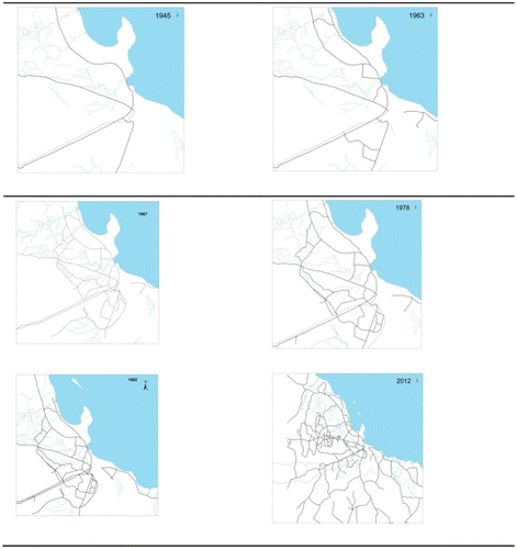
The maps below (Map ) show sequential growth of the city from 1945 to 2012, which is the result of population growth and economic improvements.
The city’s spatial growth varies with time. The series of maps above indicates temporal city growth from 1945, when its size was not more than 10 km2. Today, the situation is different with the city overwhelmed by population growth. Table shows the rate of the city’s temporal spatial growth from only 9 km2 by coverage in 1945 to 927 km2 in 2012. The results indicate that for the past 20 years, the city grew to 715 Km2 from 1996 to 2012, a situation sharply different from 40 years ago when the city grew to 203 km2 from 1945 to 1992. The impact of this swift growth has mostly been a rise in demand for housing creating intense pressure on land. Urban growth, however, does not conform to city planning, resulting in a significant percentage of informal settlements.
Table 6. Dar es Salaam Urban Growth from 1945 to 2012 shows latent growth, but an escalation from 1996 onward.
The city’s growth whose rate was gradual after independence suggesting that economic growth had a direct connection to employment as Table indicates. Data for the period of the economic crisis between 1970 and 1990s are not available. Generally, for the years with available data, economic and population growth both grew. Historically,Dar es Salaam population compared to other main regions is keeping higher (Figure ).
Table 7. The rate of employment in Dar es Salaam from independence in 1961–2012: the rate grew continuously but stopped between the 1970s and 1990s, due to economic depression.
Dar es Salaam’s growth comes in large part from the opportunities for employment available from many institutions found in the city, including universities, hospitals, numerous businesses, international organizations, and diplomatic missions. Its port services most of east and central African landlocked countries like Rwanda, Burundi, Uganda, Zambia, Zimbabwe, and Malawi (UN-Habitat, Citation2013a; Zhong, Li, Xiang & Zhu, Citation2013) (Figure ). In comparison with other big cities in East Africa for example Kampala city, of Uganda the population in Dar es Salaam is found to be higher (Figure ). Dar es Salaam is a venue for tourism due to its convenient connection to Zanzibar, Morogoro, and southern Tanzania, in addition to its international airport connecting Tanzania to the rest of the world, while its railway station links the city to other regions and neighboring countries. These connections also contribute to population growth through business, industry, and tourism as well as immigrants for DR Congo, Rwanda, Burundi, Zambia, Malawi, Mozambique, Uganda, and Kenya (World Bank, Citation2012).
4.3. Spatial and temporal growth of transportation from 1945 to 2012
This section will provide answers to how transportation in Dar es Salaam is growing spatially with time. The analysis shows that transportation services and physical infrastructure have been growing at a substantial pace (Table ).
In Dar es Salaam generally, transportation infrastructure expansion coincides significantly with population growth. In contrast, urban spatial expansion and residential area growth have been affected by transportation infrastructure expansion (Map ). Moreover, population growth seems to have caused an increase in daily trips, trips, and travel demand and consequently congestion. In Dar es Salaam, there has been enormous expansion caused by dramatic changes in daily share modes. There are great disparities between urban growth and transport.
The government has taken initiatives to improve the situation in the city (Transport Policy, Citation2008) through transportation policy interventions and various development processes, though these have not proven successful.
4.4. Analysis by modeling
To arrive at the findings of ArcGIS (mapping clusters), the cluster and outlier analysis model (Anselin Local Moran’s) was used during this analysis, to quantify the level of significance based on population density (Map ). The level of significance in this study determined by population density indicates that areas around the city center with high population density (Map ) have the highest level of significance compared to fringe areas.
It also shows the population is growing temporally from high level to high (H–H) in areas within 10 km from the city center, i.e. Sinza, Oyster Bay, Manzese, Temeke, Tandika, and Buguruni. It also indicates that areas around the city center and the port area are not significant, which may be true because these areas have changed into commercial areas and, therefore, not populated. Moreover, living in the vicinity of the CBD is very expensive and few can afford it.
Areas around the southeast of the city 10–20 km from its center have a significance level of L–L (low–low) despite being areas earmarked for the future new city. The reason may be that residents are moving to new locations to give way to development. Generally, the city is clustered around the center and dispersed toward the fringes. Map shows many closed clusters around the city center, but more dispersed with distance toward the fringes. Its H–L (High to Low) density nature is not available in the results, but shown on the key legend.
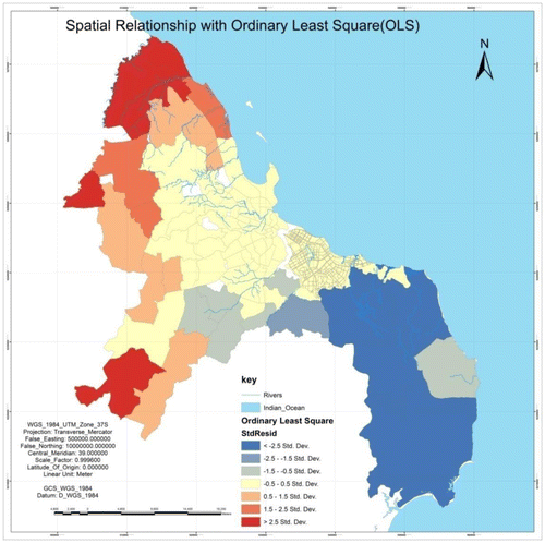
4.5. Analyzing spatial relation with ordinal least square
The other GIS model used was ordinal least square, which provides basic correction of the spatial data and shows prediction of patterns. By taking values from the results of spatial autocorrelation, the ordinary least square was calculated, and the results show that the degree of closeness to the city center is more compact and it decreases with distance toward the fringes. The computations were made using population density as a parameter; therefore, with a correlation map (Map ), we can vindicate the results indicating the relation is gradually transforming from yellow to orange, then to red, as it keeps on transforming as one moves from the city center to the fringes. The pattern does not apply so much in the south and east sides because these areas are not well developed. The concept used the threshold number to determine high and low density. This concept as well applies with the increase in land value and, therefore, house prices as we move away from the city center.
Map 7. The spatial relationship by ordinal least square (OLS) indicates the population is more concentrated (high density – yellow color) around the city center, but decreases (brown orange to red) with positive value toward the northern and western areas and then decreases with negative values (grey – light grey to blue) indicating that land is sequentially reduced to empty as you reach the south and southeastern areas.
4.6. City spatial growth and spatial transportation growth
Table shows the trend of urban and road network growth and expansions from 1945 to 2012. It indicates transport infrastructure expansion is strongly correlated with population growth, spatial expansion, and land use changes. Map shows an enormous continuance of growth from 1945 to 2012 caused by population growth which increased daily trips and transportation demands leading to an increase in congestion. The number of roads with a four-finger pattern in 1945 is very clearly elaborated, but the web of roads has grown into a complex network web by 2012. Temporal analysis made in Map shows the city’s temporal growth that has been contributed by population and economic growth as analyzed above. This growth is making it more complex with the pace of urban challenges growing as well. This paper provides more analysis in the subsequent sections (Table ).
Table 8. The relationship between urban spatial growth and transportation.
Map 8. Road expansion from 1945 to 2012 (Source: Master Plan Citation1979 and Tan roads) the city is shaped by four major roads which provide important links to other roads. The resulting complexity has been growing parallel with the pace of population and economic growth.
The mobility modal share in Dar es Salaam is dominated mainly by public transport followed by walking (Figure ). Residents apply different mobility modes and they change with time (Table ). This study focuses on 1979 onwards (because of data availability). Dar es Salaam had a population of 843,000 people, most whose main means of mobility used to be walking. At the moment, the city fringe was not more than 10 km from city center. Probably, some would tolerate 10-km walk to reach their destination. Modal share started to shift gradually and public transport deployed by government changed to private people. Until recently, public transport was this paramount means of mobility. However, service is not decent and convenient. Over time, the attitude of residents toward car ownership improved, and then the spike in private car ownership is now attributed to problems in public transport.
The results of the analysis of the data indicate that there is a relationship between the economy, population, spatial growth, and road growth. In 1945, the city had only four major primary roads connecting its center with fringes covering only 9 km.
4.7. Economic growth and transportation
For more than a decade now, economic growth in Dar es Salaam has been linked to population and transportation growth Figure . Dar es Salaam GDP growth is coincided with population, transportation, and urban growth.
The scattered graph below (Figure ) indicates the connection between transportation and the city’s economic growth. Economic growth of the city depends on more investment in the city and GDP growth. The latter is said to be caused by an increase in outputs from industrial production induced by population growth which provides cheap labor.
The graphs indicates that there is, but not very direct or simultaneous, connection between economic and transportation growth, for example, from years between 1980 and 1995 (they intersect in the middle). Generally, we can state that there has been simultaneous growth in the economy and transportation which reached a turning point in 1995, when investment in infrastructure rose above GDP as indicated in the graph as a result of enjoying the benefits of political will, especially in Dar es Salaam, where the central government and diplomatic missions are located. Generally, the economy of Tanzania has been steady for almost 20 years as indicated in the graph.
4.8. Recommendations
Taking into account the research, further studies on the mutual relationship between transportation and urban growth using the presented approach for other mono-centric urban, structured cities is desirable.
Inclusion of socioeconomic aspects such as income must be considered in analyzing the interaction between urban growth and transport. It also should involve the impact of spatial and temporal distribution of different population groups in terms of their income or social status on patterns of household trips or traffic movement in the city.
It is recommended that more studies be carried out to analyze a variety of policy interventions and examine the capability of any new proactive approaches of how to make the most use out of land for planning transport infrastructure. These solutions can be applied to other growing cities in the Global South which have mixed land use and multi-transport systems.
Planners and policy-makers in Dar es Salaam must be appreciated that more and more people continue to migrate to the city thus expanding its population, and spatial planning must prioritize adequacy to accommodate this growth.
Arterial grid roads in Dar es Salaam may contribute to the introduction of an effective public transport system that extends far into the urban fringes; however, putting in place an arterial road is not a guarantee in or of itself that the grid will be used effectively to carry public transport unless deliberate and lasting measures are taken.
As Dar es Salaam keeps expanding, the necessary land for public streets, public infrastructure networks, and public open spaces must be secured in advance of developments. This should include right of way for arterial grid roads, preferably spaced 1 km apart and within walking distance from the interior of the area they enclose. The grid can carry public transport and trunk infrastructure as well as facilitate drainage.
Most of the studies indicate that the threshold for the establishment of a metro (subway) is the population of 5 million people; therefore, for a city like Dar es Salaam, which will be a megacity for the next 20 years (UN-Habitat, Citation2014), it is better to foresee in advance a subway or light rail system for public mobility which other major cities such as Lagos and Nigeria have already started.
5. Discussion and conclusions
The simultaneous relationship between spatial city temporal expansion in relation to spatial transportation expansion due to population and economic growth is significant as it has showed the link between the four entities. The trend of growth has a negative impact on the continuation of future growth; consequently, policy-makers and urban planners should take precautions to mitigate negative impacts that may result from it.
The findings of this research have implications for developing countries, which for the past 20 years have seen their populations grow faster and simultaneously with their economies leading to high population increases in big cities linked to immigrants from other regions.
Overall, the findings of this study show that there is mutual relationship between Dar es Salaam urban growth, population, economy, and transportation. It found that transportation demand and infrastructure growth coincide with population growth. However, Dar es Salaam’s urban spatial expansion and residential area growth have been affected by transportation demand and infrastructure growth. The enormous spatial expansion has caused dramatic changes in the daily share of travel modes. These disparities have occurred in relation between urban growth and transport. The pattern of development process and policies intervention which has taken place has not been successful in solving these problems.
Transport infrastructure expansion in Dar es Salaam is mutually related to population growth, spatial expansion, and land use change. Additionally, urban spatial expansion and residential area growth are catalyzed by transport infrastructure expansion. The imbalance between travel demand and transport infrastructure has rendered an increase in congestion. Also in Dar es Salaam, there is huge influence of transport infrastructure on spatial temporal expansion and land use change. The main roads and highways (Morogoro, Kilwa, Ally HassanMwinyi, and Mandela) have a stronger influence on spatial expansion and land use change compared to secondary roads.
Notes
1. Daladala is a small minibus and medium-sized privately owned city buses. The name is old slang for 5 Shillings, the standard fare when the service was first introduced.
2. KAMATA is the Swahili abbreviation for National Bus Company.
3. UDA-Usafiri Dar es Salaam –Swahili for transportation in Dar es Salaam.
4. Informal sector is employing a big number of residents in Dar es Salaam than formal Sector.
References
- Aljoufie, M., Zuidgeest, M., Brussel, M., & van Maarseveen, M. (2013). Spatial–temporal analysis of urban growth and transportation in Jeddah City, Saudi Arabia. Cities, 31, 57–68.10.1016/j.cities.2012.04.008
- Amer, S. (2007). Towards spatial justice in urban health service planning (PhD thesis). ITC, International Institute for Geo-Information Science and Earth Observation, University of Utrecht, Enschede, The Nertherlands. 315 p.
- Augustijn-Beckers, E.-W., Flacke, J., & Retsios, B. (2011). Simulating informal settlement growth in Dar es Salaam, Tanzania: An agent-based housing model. Cities, 31, 57–68.10.1016/j.compenvurbsys.2011.01.001
- Baffour Awuah, K. G., Hammond, F. N., Lamond, J. E., & Booth, C. (2014). Benefits of urban land use planning in Ghana. Geoforum, 51, 37–46.10.1016/j.geoforum.2013.09.019
- Chissano, M. P. H., & Minnery, J. (2014). Roads, rates and development: Urban roads and growth in Xai-Xai, Mozambique. Habitat International, 42, 48–57.10.1016/j.habitatint.2013.10.007
- Diaz Olvera, L., Plat, D., & Pochet, P. (2003a). Transportation conditions and access to services in a context of urban sprawl and deregulation. The case of Dar es Salaam. Transport Policy, 10, 287–298.10.1016/S0967-070X(03)00056-8
- Diaz Olvera, L., Plat, D., & Pochet, P. (2003b). Transportation and acess to urban services in Dar es Salaam. Proceedings of International conference, 87–93.
- Diaz Olvera, L., Plat, D., & Pochet, P. (2008). Household transport expenditure in Sub-Saharan African cities: Measurement and analysis. Journal of Transport Geography, 16, 1–13.10.1016/j.jtrangeo.2007.04.001
- Diaz Olvera, L., Plat, D., & Pochet, P. (2013). The puzzle of mobility and access to the city in Sub-Saharan Africa. Journal of Transport Geography, 32, 56–64.10.1016/j.jtrangeo.2013.08.009
- Gulyani, S., Bassett, E. M., & Talukdar, D. (2014). A tale of two cities: A multi-dimensional portrait of poverty and living conditions in the slums of Dakar and Nairobi. Habitat International, 43, 98–107.10.1016/j.habitatint.2014.01.001
- Halla, F. (2007). A SWOT analysis of strategic urban development planning: The case of Dar es Salaam city in Tanzania. Habitat International, 31, 130–142.10.1016/j.habitatint.2006.08.001
- Hill, A., & Lindner, C. (2010). Land-use modelling to support strategic urban planning - the case of Dar es Salaam, Tanzania. Simulating informal urban growth in Dar es Salaam, Tanzania; 45th ISOCARP Congress, 2010, 12 p.
- Hsieh, S.-C. (2014). Analyzing urbanization data using rural–urban interaction model and logistic growth model. Computers, Environment and Urban Systems, 45, 89–100.10.1016/j.compenvurbsys.2014.01.002
- Kironde, J. M. L. (1997). Land policy options for urban Tanzania. Land Use Policy, 14, 99–117.10.1016/S0264-8377(96)00040-3
- Kironde, J. M. L. (2000). Understanding land markets in African urban areas. Habitat International, 24, 151–165.10.1016/S0197-3975(99)00035-1
- Kombe, W. J. (2005). Land use dynamics in peri-urban areas and their implications on the urban growth and form: The case of Dar es Salaam, Tanzania. Habitat International, 29, 113–135.10.1016/S0197-3975(03)00076-6
- Kombe, W. J., & Kreibich, V. (2001). Informal land management in Tanzania and the misconception about its illegality. A paper presented at the ESF/N-Aerus Annual Workshop “Coping with Informality and Illegality in Human Settlements in Developing Countries”, Leuven, May 23–26, 2001, 15 p.
- Linard, C., Tatem, A. J., & Gilbert, M. (2013). Modelling spatial patterns of urban growth in Africa. Applied Geography, 44, 23–32.10.1016/j.apgeog.2013.07.009
- Lupala, J. M. (2002). Urban types in rapidly urbanizing cities (PhD Thesis). Department of Infrastructure and Planning, Tryck hos Universitetsservice, Stockholm. 280 p.
- Master Plan. (1979). Dar es Salaam Master Plan. Marshal and Macklin Monaghan Ltd, Ontario, Canada.
- Master Plan. (2012). Draft Dar Es Salaam Master plan 2012–2032. Minisrty of Lands. 366 p.
- Mbiba, B. (2014). Urban solid waste characteristics and household appetite for separation at source in Eastern and Southern Africa. Habitat International, 43, 152–162.10.1016/j.habitatint.2014.02.001
- Ministry of lands. (2002). Kariakoo Area Redevelopment Plan. U. Planning: 50.
- Mkurunzinza, A. (2013). Sustainable Tranport in Dar es Salaam (PhD thesis). ITC, Facult of Geo-Information Science and Earth Observation, University of Twente, Enschede, The Netherlands. 192 p.
- Ogbazi, J. U. (2013). Alternative planning approaches and the sustainable cities programme in Nigeria. Habitat International, 40, 109–118.10.1016/j.habitatint.2013.03.001
- Oosterveer, P. (2009). Urban environmental services and the state in East Africa; between neo-developmental and network governance approaches. Geoforum, 40, 1061–1068.10.1016/j.geoforum.2009.08.009
- Rizzo, A. (2014). Rapid urban development and national master planning in Arab Gulf countries. Qatar as a case study. Cities, 39, 50–57.10.1016/j.cities.2014.02.005
- Seto, K. C. (2011). Exploring the dynamics of migration to mega-delta cities in Asia and Africa: Contemporary drivers and future scenarios. Global Environmental Change, 21, S94–S107.10.1016/j.gloenvcha.2011.08.005
- Sohail, M., Maunder, D. A. C., & Miles, D. W. J. (2004). Managing public transport in developing countries: Stakeholder perspectives in Dar es Salaam and Faisalabad. International Journal of Transport Management, 2, 12.
- Tanzania Revenue Authority. (2013). CMRS VEH STAT2003-2013. Excel. C. V. STAT2003-2013. 48kb.
- Transport Policy. (2008). Dar es Salaam Transport Policy and System Development Master Plan. Dar es Salaam Council. Dar es Salaam, The United Republic of Tanzania 2, 210 p.
- Transport Policy. (2008). Dar es Salaam Transport Policy and System Development Master Plan. J. I. C. Agency, Dar es Salaam City Council, The United Republic of Tanzania. 200 p.
- Un-Habitat. (2010). The State of African Cities 2010; Governance, Inequality and Urban Land Markets. United Nations Human Settlements Programme (UN-HABITAT) P.O. Box 30030, Nairobi, Kenya, United Nations Human Settlements Programme (UN-HABITAT). ISBN Number: (Volume) 978-92-1-132291-0:280.
- UN-Habitat. (2013a). Urban planning for city leaders Nairobi GPO KENYA, 2nd ed. United Nations Human Settlements Programme (UN-Habitat). 187 p.
- Un-Habitat. (2013b). Planning and Design For Sustainable Urban Mobility Global Report on Human Settlements 2013. First published 2013 (this electronic version has been revised on 15 January 2014 and includes errata reported by this date). by Routledge 2 Park Square, Milton Park, Abingdon, Oxon, OX14 4RN Simultaneously published in the USA and Canada by Routledge 711 Third Avenue, New York, NY 10017 Routledge is an imprint of the Taylor & Francis Group, an informa business, United Nations Human Settlements Programme (UN-Habitat): 348.
- UN-Habitat. (2014). The state of African Cities 2014; Re-Imagining Sustainable Urban Transitions. Nairobi 00100, Kenya, United Nations Human Settlements Programme (UN-Habitat). ISBN Number (Volume): 978-92-1-132598-0:278.
- Vermeiren, K., Van Rompaey, A., Loopmans, M., Serwajja, E., & Mukwaya, P. (2012). Urban growth of Kampala, Uganda: Pattern analysis and scenario development. Landscape and Urban Planning, 106, 199–206.10.1016/j.landurbplan.2012.03.006
- Watson, V. (2009). ‘The planned city sweeps the poor away…’. Urban planning and 21st century urbanisation. Progress in Planning, 72, 151–193.10.1016/j.progress.2009.06.002
- World Bank. (2011). Cities and climate change. Edited by D. Hoornweg, M. Freire, Marcus J. Lee, P. BhadaTata and B. Yuen. Washington, DC: World Bank. 328 p.
- World Bank. (2012). Urban risk assessments: Understanding disaster and climate risk in cities. Edited by Eric Dickson, Judy L. Baker, D. Hoornweg and A. Tiwari. Washington, DC: The World Bank, 276 p.
- World Bank. (2013). Building sustainability in an urbanizing world. Edited by Daniel Hoornweg, Mila Freire, Julianne Baker-Gallegos, & A. Saldivar-Sali. World Bank: Washington, DC, USA, No. 17, 216 p.
- Wubneh, M. (2013). Addis Ababa, Ethiopia – Africa’s diplomatic capital. Cities, 35, 255–269.10.1016/j.cities.2013.08.002
- Zhong, F.-N., Li, Q., Xiang, J., & Zhu, J. (2013). Economic growth, demographic change and rural-urban migration in China. Journal of Integrative Agriculture, 12, 1884–1895.10.1016/S2095-3119(13)60597-3