
Abstract
The article examines: 1) how travel behaviour was influenced by urban form in three terrorism-affected Baghdad districts; and 2) how the responses to terrorism in these neighbourhoods affected travel behaviour. The results suggest that urban form can mediate the impacts of terrorism and counter-terrorism with traditional urban form districts being more resilient than modern high-rise districts.
Introduction
A range of factors can affect transportation behaviour within an urban environment. For example, urban form and land use can play a significant role in shaping individual travel behaviour. Pan et al. (Citation2009) demonstrate that traditional urban form can greatly restrict transport behaviour because it makes the use of motorized modes more difficult while making non-motorized modes such as walking and cycling easier. Conversely, modern urban form tends to increase private motor vehicle use for commuting and other travel (Cervero & Day, Citation2008). The use of the private motor vehicle is convenient because it can provide travel options of a range of household activities; hence motor vehicles strongly influence travel behaviour (Buliung & Kanaroglou, Citation2006). Individual travel behaviour can be affected by urban form, land uses and their activities.
However, travel behaviour can also be dramatically affected by terrorism and counter terrorism measures. The destruction of transport infrastructure and measures to counter terrorism are the main factors affecting travel behaviour. In Baghdad, acts of terrorism, particularly in crowded markets and institutions, have changed daily activities, routes and transportation modes. Individuals have adopted defensive behaviours to protect themselves from terrorism. Many daily activities and trips that previously occurred at the district level, now take place within smaller more confined neighbourhoods. This change in travel behaviour has been exacerbated by the damage to transport infrastructure and subsequent rebuilding efforts. Furthermore, the use of counter-terrorism measures in the form of precast concrete barriers has also affected travel behaviour.
In spite of these observable behaviours, there are gaps in understanding the relationship between urban form, travel behaviour and terrorism. Therefore, this paper examines: (1) how travel behaviour was influenced by urban form in three terrorist-affected Baghdad neighbourhoods; and (2) how the responses to terrorism in these neighbourhoods affected travel behaviour.
Literature review
Urban form, design and policies can play a significant role in creating secure and more sustainable environments. They can also play an important role in shaping individual travel behaviour through the control of household daily travel. This in turn can minimize motorized travel and reduce its environmental impacts (van Wee & Handy, Citation2014). The quality and quantity of transport facilities within an urban area contributes to the volume of travel and the modes that are used (Giles-Corti et al., Citation2013).
The role of urban form in individuals’ travel behaviour can be affected by the surrounding circumstances. For example, insecure circumstances including war and terrorist acts can add major challenges to daily activities and individual travel behaviour. The fear of terrorism and the minimum practice of urban daily activities is one of the usual and known challenges. A terrorist act that aims to create a fearful state of mind in an audience different from the victims (Ruby, Citation2002).
The review of literature on the war and terrorism impacts on transportation confirms that terrorists target transport infrastructure because it disrupts urban life and individual movement. For example, the terrorist attacks on transport in the US, UK, France and Tokyo suggest a focus on transport systems (Jenkins & Gersten, Citation2001). The terrorist attacks on the US Navy ship in Yemen, the aircraft used in the 9/11 attacks in New York, Washington, DC and Pennsylvania, trains targeted by terrorists in London and Madrid and trucks in Iraq confirm the importance of transport.
Moreover, research shows that individual transportation behaviour was significantly affected by these attacks and those threatened by terrorism were expected to support actions that decreased their terrorism exposure (Huddy, Fledman, Capelos, & Provost, Citation2002). Glaeser and Shapiro (Citation2002) argue that the continued attacks on transport infrastructure made travelling unsafe. They confirmed that these attacks created chilling behaviour among individuals during their travel on the roads; hence they reduced their use of transport to avoid exposure to terrorism. The evidence from those who had experienced terrorism attacks and threats found that they were continually changing their travel modes, and had adopted new behaviour to protect themselves against terrorist acts. Gigerenzer (Citation2006) highlighted this point with the fact that prior to 9/11, a majority of Americans preferred to travel by air, but after 9/11 air travel dropped sharply. This resulted in an increased use of driving which caused an increase in the number of road crash deaths.
In the past, traditional urban form used elements such as overhangs, small courtyards and decorative bollards around alleys to increase security and guide travellers and hence to control behaviour. Newman (Citation1995) describes a successful defensible space as a place that gives pedestrians a series of psychological cues to guide their movement and behaviour. He confirms the impact of security concerns and the physical elements on individual behaviour. Likewise, contemporary security, concerned with the use of fortification elements and technological methods to cope with the terrorist acts and protect transportation infrastructure, also affect individual behaviour because it tends to restrict free movement, flexibility and route choice. While many of these measures are no longer in place, Coaffee (Citation2003) described the types of security measures used in Belfast, Northern Ireland – concrete barriers, rings of steel and gated fences that divided the city centre into separate zones with only limited vehicle entrances. Movement of cars and parking was restricted with only two car parking areas that significantly affected transport behaviour. Moreover, these measures created an “atmosphere of fear and a culture of surveillance that have consequences for social control and freedom of movement” (Coaffee & Rogers, Citation2008, 106). Graham (Citation2008) demonstrated that pushing cars outside of the security cordon increased the possibility of attack in neighbouring areas, so surveillance cameras were added to monitor movement of cars and to increase security. Moreover, the Belfast methods were used to secure London against terrorism; however, rings of plastic were used instead of rings of steel. Wigan and Clarke (Citation2006) argue that one unintended consequence of electronic surveillance of transport is that individuals’ daily activities may be impeded more than any terrorist acts.
A review of the research on terrorism’s influence on transport infrastructure highlights two points. First, there is very little discussion on how terrorism and related security measures affect transport, travel behaviour and daily activities. Second, almost no research has been conducted in high-risk areas, like Iraq because of unstable security and a lack of reliable information sources. Savitch (Citation2008) indicated that the lack of security/safety as well as restricted data sources and accuracy made him exclude countries like Iraq from his research.
Methods of data collection and analysis
Two forms of data collection were used – a questionnaire administered to the district residents and semi-structured interviews of planning professionals and university academics.
The questionnaire was used to collect data from three Baghdad neighbourhoods. It was designed to explore the influence of urban form on travel behaviour in terrorism affected districts. The questionnaire included questions about: individual characteristics; daily activities and routines, travel routes and modes, number of cars owned and use of general facilities. The objective of this research, as noted above, was to see if there were any statistically significant differences in responses across the three Baghdad districts.
The process of data collection was not easy. Baghdad’s unstable security circumstances made conventional data collection methods difficult. Therefore, special methods were used to make primary data collection possible and safe. Two strategies were employed; the first was to use the Mukhtar, a respected individual and well known to local residents. The Mukhtar was important for the following reasons: (1) he introduced the research team to local residents in the community; (2) he was able to secure permission from local authorities and security organizations to conduct the survey; (3) because of his status in the community he provided a safety factor that encouraged local residents to participate in the survey; and (4) he provided an introduction to the Imam (see below).
The second strategy involved the use of another influential member of the local community – the Imam of the Mosque (Sheik). As noted above, the Mukhtar provided the introduction of the researchers to the Imam. The involvement of the Imam also helped to encourage individuals to participate in the survey. The use of the Imam was important for two reasons: (1) it helped to ensure the accuracy of responses on the questionnaires as they were administered at the mosque in the presence of a trusted person; and (2) it helped to get more participants within a short period of time because the questionnaire was distributed during Friday prayers, so there were a large number of participants. Data were collected outside of four mosques: two in the Centre of Rusafa; one in Falestin; and one in Haifa. The survey team included three persons who helped distribute and collect the questionnaire after prayers. The survey was administered over six weeks in the latter part of 2012. The number of the completed questionnaires across the three districts was 281.
We acknowledge the bias in using these strategies given that the overwhelming majority of participants were males that attended Friday prayers. Social norms and traditions as well as security concerns prevented direct contact between the researchers and female residents. These data collection concerns have prevented research in Iraq, which is evidenced by the paucity of academic research on this topic (Savitch, Citation2008). As researchers, we decided that there was no other realistic alternative to collecting these data. Thus, the findings presented here need to be considered in light of this bias.
The questionnaires were coded and analysed using SPSS in an effort to see if there were any statistically significant differences in travel behaviour across the three case study districts. One of the main objectives of the research was to see if travel behaviour was affected by the district’s urban form.
Interviews were conducted with 20 urban planners, architects and other professionals from government and the private sector. The primary purpose of these semi-structured interviews was to help: (1) frame the survey questions; and (2) interpret the survey results. The interviewees were selected based on their knowledge of and experience in: (1) the designs used by individuals in case study areas; and (2) the consequences of war and terrorism on urban form. All of the professionals interviewed were residents of Baghdad – fifteen were male and five were female. The interviews focused on questions aimed at identifying the changes in urban form resulting from war and terrorism. The interviews were analysed using Microsoft Excel.
Selection of case study areas
Within Baghdad’s inner urban area, three case study areas were selected for analysis as shown in Figure . The first was Centre of Rusafa, located in the centre of Baghdad and extending along the Tigris River for 4,000 metres. Its population in 2007 was estimated to be 164,119 (Iraqi Central Census 2007) and is bounded on the south-west by the Tigris River, on the north-east by the Mohammad Al-Kasm highway, on the north-west by the Bab Al-Moazam Bridge and on the south-east by Al-Tahreer intersection.
Figure 1. Map of the case study areas.
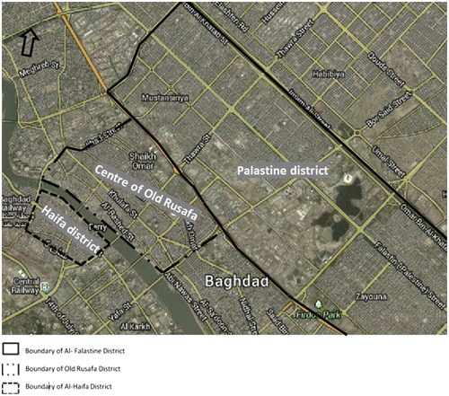
The second case study area was Falestin, which is located north-east of the centre of Rusafa district. It is part of the New Baghdad district and had a 2007 population of 870,462 (Iraqi Central Census 2007). It is bounded on the south-west by the Mohammed Al-Kasm highway (shared with Al-Rusafa), on the north-east by the highway of the Army Channel, on the north-west by the Mustansiriya Square (Safi Al Din Al Hilli Street), and on the south-east by Al Maysaloon Square.
The third case study area was Haifa district. It is located on the opposite side of the Tigris River from Rusafa. The official 2007 population estimate for the Kharh district which contains Haifa was 139,079 (Iraqi Central Census 2007). Haifa is bounded on the north-east by the Tigris River, on the south-east by Al Nasr St, on the south-west by Shaik Maruf Street, and on the north-west by Shehab Square.
These case study areas where selected because they represent contrasts of physical and social attributes including the historical development, building styles, urban layouts, administrative functions, economic functions, population demographics and household characteristics. Table shows the characteristics of each district.
Table 1. Comparison of the case study areas.
Case study area #1 – centre of Rusafa district
Baghdad is one of the oldest cities in the world. Its history dates back to about AD754–775, when the first stone was erected by the Abbasid Caliph, Abu Ja’far Al-Mansour to erect The Round City (Lassner, Citation1968). The centre of Rusafa is considered one of the oldest centres, not only in Baghdad but also in the world. The district central location in the heart of Baghdad city as well as the presence of historical buildings such as Al-Moustansirya school, Abasi Palace, Baghdadi Museum, Al Qishla (alarm clock), old defence ministry, Saray Sq, Marjan Kan, the Museum of Pioneers and Artists, the Place of culture and arts has given it attractive and distractive features and are the key features of heritage factors in the district.
This district is also considered the heart of Iraq’s commercial activities. Its strategic location, network of roads, as well as the presence of the Tigris River, are the main factor for its dominant economic role. Meanwhile, the presence of the Ministries of Higher Education and Industry and Minerals has supported its administrative importance.
The district’s urban form, represented through its unique urban fabric, contains traditional types of Al-Baghdadi houses and alleys, as well as the presence of social and cultural places and streets such as Abu Nuwas Street, Al-Rashid Street, and Al-Motanabee Street. Moreover, the presence of social cafes and public libraries, have made this area a key social and cultural centre of the region.
Case study area #2 – Falestin district
Falestin is one of the most distinctive districts in Baghdad. It embraces Falestin Street, which is considered one of the most important and longest streets in Baghdad. Development started in this district in the early 1960’s.
The district is surrounded by two highways: Mohammed Al-Kasm, and the Channel of Army. These give it more accessible routes as well as a strategic relationship with the surrounding districts. The district contains a number of important residential and commercial parts including Palestine, Robayee, Al-mustansiriya, Idrissi, Almuhandseen, Nile and Al-Zayouna. Each of these neighbourhoods has its unique and distinctive features in terms of type of residences and size of property and date of construction. The presence of unique universities and colleges, as well as the cultural institutes, represent the main features of the district such as Al-Mustansiriya University, Al-Rafideen College, teacher training institute as well as the distinctive secondary school
The administrative importance of this district is due to the presence of a number of official buildings and ministries, such as the Ministry of Oil, Transportation, Water resources and interior. Moreover, the official directorates such as Military Survey, General Traffic, Housing and College of Police are located in the district.
This district is considered one of the main social and entertainment centres in Baghdad. The district is well known for formal and informal ceremonies. The construction of social and entertainment clubs such as General’s Entertainment, Air Force as well as the presence of official institutes such as Iraqi House for Fashion increasingly encouraged the social and entertainment activities.
Case study area #3 – Haifa district
This area, across the Tigris River from Rusafa, has a number of distinctive characteristics and contains both traditional and modern forms. Parts of this area have been built with modern design with structures and are completely different from Rusafa. Multi-story buildings and pre-cast construction were used for the first time in Baghdad in this district.
There are number of amazing traditional zones within the district. They are located behind and along Haifa Street and are considered of heritage conservation zones (AMANAT AL ASSIMA & Alousi Associates, 1980–1985).
This area is the new administrative centre of Iraq. It contains a number of official and government buildings including the Ministries of Finance, Municipalities, Justice, and Tourism. Being close to the Green Zone has increased its administrative role. The Green Zone is the centre and location of the residences of the Iraq president and Prime Minister as well as the home of the Iraqi Parliament. This zone contains the majority of governmental ministries as well as many international embassies.
This area has eight unique sections along Haifa Street with each section’s design representing a particular event. Some parts represent Iraqi historical icons and others embody Al-Baghdadi house (Alshanashil). All these parts share Iraqi traditional streets in the use of arcades, but in modern appearance.
Terrorist activities in case study areas
When selecting the case study areas, we considered and compared the number and severity of terrorist attacks across the city. Obtaining this information from official sources was not possible; therefore we relied on data collected from a variety of news sources including Gene Thorp/Washington Post (Citation2009). These data allowed us to examine the general location and number of terrorist attacks in and around the three case study areas. They suggest that terrorist attacks have occurred in all three case study neighbourhoods; however, it is difficult to determine the actual number.
These terrorist attacks have targeted urban infrastructure, government buildings, military sites, and places were large number of people congregate such as schools, markets and cafes. The main methods used in these attacks were suicide bombs and car bombs.
What follows is a description of specific terrorist attacks in each of the case study areas and shows that similar types and numbers of attacks have affected all three areas. These examples are indicative of the targets, methods, loss of life and extent of damage to infrastructure.
Terrorist attacks in case study area #1 – centre of Rusafa
As the historic centre of Baghdad there have been many terrorist attacks in this district in the form of car bombings and suicide attacks.
Terrorist attacks in case study area #2 – Haifa
According to the official sources, this district was the most dangerous zone and the centre of terrorist attacks and insurgents’ gathering. On 9 January 2007 about 1,000 American and Iraqi troops, which were supported by helicopters and fighter jets, battled insurgents in one of the most dramatic operations to push the insurgents out of Al-Haifa Street. Iraqi official sources announced that at least 50 militants were killed during the operation (Santora, Citation2012).
Terrorist attacks in case study area #3 – Falestin
After 2003, the majority of residents believed Falestin to be the best and safest district to live compared to others in Baghdad. But this area has not been free from terrorist attacks. Because this is area with many administrative buildings, it has seen scores of terrorist attacks that have not distinguished between civil and official targets.
Findings
The survey findings are provided below. The first section provides background demographic and housing characteristics of the three case study districts. These characteristics are important because family size and the number of households accommodating multiple families directly impact on travel behaviour particularly the number of trips. As the household size grows, so does the number of trips. The second section provides results from the questions about travel behaviour.
Demographic and housing characteristics
A majority of respondents owned their home with home ownership being somewhat lower in Haifa (60%) compared to the Centre of Rusufa (76%) and Falestin (80%) as shown in Table .
Table 2. Housing tenure status.
The family size was similar across the three districts with the majority of families having four or more members. In terms of household size, 57% of Haifa households were one family. In the Centre of Rusufa, 57% of the households were two families and in Falestin 83% were two family households as shown in Table . In addition, respondents indicating that they lived with their parents were similar across all case study areas – about 70%.
Table 3. Household size.
In order to accommodate multiple families, structures had to be altered. As Table shows, the methods varied across the case study areas with 74% of Haifa respondents indicating they had repartitioned interior spaces with 14% having converted their garden into living space compared to the Centre of Rusufa where 34% had repartitioned their interior space with 30% having added a new flat. In Falestin, 26% added a new flat and 51% converted their garden into living space.
Table 4. Methods used to accommodate families.
Since 2003, 86% of respondents in Haifa indicated that buildings had been affected in their neighbourhood compared to 63% in Falestin and 39% in Centre of Rusufa. Residents were also asked whether any buildings had been damaged or had been evacuated in their districts. There was a wide disparity in responses with 86% in Haifa responding that this had occurred compared to 44% in Falestin and 39% in Centre of Rusafa.
The survey results were supported by the information provided from the interviews. Eight of the 20 interviewees indicated that security concerns were the main motivation for residents altering their dwellings (splitting units or converting gardens) to accommodate additional people. Another eight of the sixteen interviewees blamed weaknesses in building regulations and monitoring systems for the spread of dwelling unit alterations and for building materials used in these alterations that were not common prior to 2003.
Transportation impacts
Travel was affected by terrorist activities and by the security and safety counter-terrorism measures put in place by government. The use of precast concrete barriers, temporary checkpoints and curfew actions were very effective in protecting the public in part because they restricted terrorist movements. But in doing so, they also restricted the daily movements and activities of district residents. What is surprising however is that while the threat of terrorism and the existence of counter-terrorism measures were similar across the three districts, there were significant differences in travel behaviour.
Daily routines
There were several questions related to the daily routines of residents in the three districts. The first was about whether their daily routines had changed since 2003. The year was chosen as it represented the transformation period in Iraq towards a new regime as well as the beginning of widespread terrorism and counter-terrorism responses. As such it represented the start of a period that significantly affected urban daily life and behaviour in Baghdad. About 46% of Centre of Rusafa respondents indicated that their daily routine had changed after 2003. This compares with 54% in Falestin residents and 94% in Haifa residents.
A second was about restrictions of their daily travel. Approximately 58% of respondents from Centre of Rusafa indicated that their daily movements had been restricted by use of precast concrete barriers, compared to 70% from Falestin and almost 100% from Haifa. This difference is attributable to the different street patterns across the three districts. The Centre of Rusufa has a street network that has evolved over the past 1,250 years, while Haifa’s network is a modern one from the 1960s with wide straight streets in a grid-iron pattern.
A third question related to traditional meeting places. Because the daily routines and routes were disrupted, meeting places also changed. As Table shows, about 94% of Haifa respondents indicated that their meeting places have changed since 2003 compared to 63% in Falestin and 42% in Centre of Rusafa.
Table 5. Change in meeting places.
Transport routes
About 53% of Centre of Rusafa respondents indicated that their route to work, school, etc. changed after 2003 compared to 63% in Falestin and 95% in Haifa as shown in Table . The high percentage in Haifa is due to: (1) the modernist urban form with wide streets; and (2) the counter-terrorism measures needed in terms of blockades, etc. to secure this type of urban form.
Table 6. Transportation route changes after 2003.
Scheduling of daily activities
This question was asked because of the limited availability of other essential services such as electricity and water. At best, electricity may only be available for 8–10 h each day. Thus many plan their activities when they know that electricity is likely to be available, particularly if they live in high-rise buildings or plan on doing business in such buildings and want to use the elevator rather than walking up and down many flights of stairs. In Falestin, 24% of the respondents preferred to schedule their daily activities hourly, whereas this was the case for only 15% of Centre of Rusafa respondents and 40% in Haifa. This result is due to the fact that Haifa is dominated by multi-story apartment buildings. In contrast, 55% of Centre of Rusafa respondents, 42% in Falestin and 35% in Haifa preferred daily schedules.
Car ownership/use
About 54% of Centre of Rusafa respondents indicated that they owned one car, whereas the results were 31% for Falestin and 48% for Haifa as shown in Table . About 65% of Falestin respondents indicated that they owned two cars compared to 42% in Centre of Rusafa and 43% in Haifa. The tendency to own three or more cars was similar across all three areas – less than 10%.
Table 7. Number of cars owned.
Centre of Rusafa respondents had the lowest level of car ownership and also the least tendency of to use it for their daily activities and shopping. This was reversed in Falestin where respondents had the highest tendency to own two cars and to use them for daily activities and shopping. Haifa respondents had similar characteristics to Falestin. The high use of private cars in Falestin and Haifa was due to several factors including: the denser urban form and activities; and the lack of good quality public transport services.
Shopping behaviour
Within Centre of Rusafa about 48% of respondents indicated that they preferred shopping at the main district centre, compared to 41% in Falestin and 31% in Haifa. Meanwhile, 50% of Falestin’s, 35% of Centre of Rusafa’s and 22% of Haifa’s respondents preferred shopping at the closest commercial centre. Shopping at the other centres was preferred by 45% of Haifa respondents, 17% of Centre of Rusafa respondents and 9.5% of Falestin respondents.
As for the preferred travel mode for shopping outside of their local district, about 39% of Haifa respondents indicated that they used their car. However, only 7% of Falestin, and 9% Centre of Rusafa respondents used their cars for this type of shopping. For these trips they largely used public transport – 36% in Falestin and about 25% in Centre of Rusafa.
Thus, about half of Centre of Rusafa respondents preferred shopping at the district’s centre, and demonstrated less preference for shopping at nearby or other district centres. On the other hand, Falestin respondents preferred shopping at the closest district centre and were less apt to shop at other district centres.
As Table shows, in Centre of Rusafa, only 3% of respondents indicated that they used a car for shopping or conducting personal business, whereas the percentage was 28% in Falestin and 20% in Haifa. Centre of Rusafa respondents preferred to walk to shops at their district centre. About 65% of Centre of Rusafa respondents preferred to walk compared to 41% in Falestin and 28% in Haifa. For shopping at nearby or other district centres Centre of Rusafa respondent’s relied on public transport.
Table 8. Travel Mode for district (neighbourhood) shopping/personal business.
To examine whether there were any statistically significant differences between the three case study districts across the range of issue discussed above, a chi-square analysis was done. As Table shows, there were statistically significant differences (at the .01 significance level) for all characteristics, except housing tenure. The results suggest that, regardless of the nature and size of the terrorist activities, travel behaviour across the three districts was significantly different. Traditional urban form appears to be more resilient from a travel behaviour perspective to terrorism and counter-terrorism impacts. While modern high-rise urban form as exhibited in Haifa is more susceptible to travel behaviour disruption due to terrorism and counter-terrorism measures.
Table 9. Pearson chi-square results.
Conclusions
It is evident from this research that terrorism and counter-terrorism measures affected daily travel behaviour, and different urban forms created different responses. The results show that the counter-terrorism measures used by government and official institutions, such as precast concrete barriers, check points and curfew conditions significantly affected the daily activities of individuals. They disrupted the use of traditional meeting places, and had a clear impact on travel behaviour. However, the results confirm that the magnitude of these impacts differed across the three districts even though they had similar functions and land use mixes. Our research suggests that the respondents of Centre of Rusafa and Falestin were least affected and those from Haifa were the most affected. These differences were most likely due to: (1) the urban form; and (2) the counter-terrorism measures that were designed for that urban form. We believe that counter-terrorism measures are context specific. In the case of these three districts, the measures required to secure areas having contemporary urban form, like that found in Haifa, appear to impact residents more severely than measures required in areas with traditional urban form, like Centre of Rusafa and Falestin.
The results also show that daily routines and schedules, as well as the use of alternative routes to work or school, changed as a result of the both the terrorism threat and the counter-terrorism measures. The results confirm that the magnitude of disruptions to travel behaviour differed across the three study areas – having a much greater impact on Haifa (modern form) and a far less impact on the Centre of Rusafa (traditional form).
This research suggests that planners in Baghdad should add terrorism and security to their list of criteria when thinking about future urban form and structure. While this paper focused on travel impacts, it was part of a larger study that examined a range of other social impacts. The impact of terrorism across a range of social areas is consistent with what was found for travel – the traditional area (Centre of Rusafa) fared much better and was less impacted than the modern area (Haifa).
The results from this analysis have wider implications beyond Baghdad, particularly for other areas experiencing severe disruptions due to terrorism and security concerns. It suggests that security should be a factor when considering future land use plans in terms of their built form and structure. While continuing to use modern urban form, as in the case of Haifa may not be advisable for the reasons discussed above, replicating traditional urban form (the Centre of Rusafa) may not be feasible due to cost and other physical and social considerations. This suggests that a district such as Baghdad’s Falestin that blends the old and new may be the most appropriate and resilient, particularly from a transport perspective.
Acknowledgement
This work was supported by the Iraq Ministry of Higher Education and Scientific Research.
References
- Buliung, R. N., & Kanaroglou, P. S. (2006). Urban form and household activity-travel behavior. Growth and Change, 37, 172–199.
- Cervero, R., & Day, J. (2008). Residential relocation and commuting behavior in Shanghai, China: The case for transit oriented development (Working Paper UCB-ITS-VWP-2008-4). Berkeley, CA: UC Berkeley Center for Future Urban Transport.
- Coaffee, J. (2003). Terrorism, risk, and the city: The making of a contemporary urban landscape. Surrey: Ashgate.
- Coaffee, J., & Rogers, P. (2008). Rebordering the city for new security challenges: From counter-terrorism to community resilience. Space and Polity, 12, 101–118.10.1080/13562570801969556
- Gene Thorp/The Washington Post. (2009). Iraq bombings interactive map and timeline. Retrieved from http://www.mapmanusa.com/cci-twp-interactive-3.html
- Gigerenzer, G. (2006). Out of the frying pan into the fire: Behavioral reactions to terrorist attacks. Risk Analysis, 26, 347–351.10.1111/risk.2006.26.issue-2
- Giles-Corti, B., Bull, F., Knuiman, M., McCormack, G., Van Niel, K., Timperio, A., Christian, A., … Boruff, B. (2013). The influence of urban design on neighbourhood walking following residential relocation: Longitudinal results from the RESIDE study. Social Science & Medicine, 77, 20–30.10.1016/j.socscimed.2012.10.016
- Glaeser, E. L., & Shapiro, J. M. (2002). Cities and warfare: The impact of terrorism on urban form. Journal of Urban Economics, 51, 205–224.
- Graham, S. (2008). Cities, war, and terrorism: Towards an urban geopolitics. Oxford: Wiley-Blackwell.
- Huddy, L., Feldman, S., Capelos, T., & Provost, C. (2002). The consequences of terrorism: Disentangling the effects of personal and national threat. Political Psychology, 23, 485–509.10.1111/pops.2002.23.issue-3
- Jenkins, B. M., & Gersten, L. N. (2001). Protecting public surface transportation against terrorism and serious crime: Continuing research on best security practices. San Jose, CA: Mineta Transportation Institute, San Jose State University.
- Lassner, J. (1968). The Caliph’s personal domain: The city plan of Baghdad reexamined. Kunst des Orients, 5, 24–36.
- Newman, O. (1995). Defensible space: A new physical planning tool for urban revitalization. Journal of the American Planning Association, 61, 149–155.10.1080/01944369508975629
- Pan, H., et al. (2009). Influence of urban form on travel behaviour in four neighbourhoods of Shanghai. Urban Studies, 46, 275–294.
- Ruby, C. L. (2002). The definition of terrorism. Analyses of Social Issues and Public Policy, 2, 9–14.10.1111/asap.2002.2.issue-1
- Santora, M. (2012, January 10). U.S. and Iraqis hit insurgents in all-day fight. The New York Times. Retrieved from http://www.nytimes.com/2007/01/10/world/middleeast/10iraq.html?pagewanted=print
- Savitch, H. V. (2008). Cities in a time of terror: Space, territory, and local resilience. Armonk, NY: ME Sharpe Incorporated.
- van Wee, B., & Handy, S. (2014). Do future land-use policies increase sustainable travel? In T. Gärling, D. Ettema, & M. Friman (Eds.), Handbook of sustainable travel (pp. 231–242). Dordrecht: Springer.
- Wigan, M., & Clarke, R. (2006). Social impacts of transport surveillance. Prometheus, 24, 389–403.10.1080/08109020601029961