
Abstract
Based on predictions, almost 60% of the world population will be living in cities by 2030. Tanzania is urbanizing at a rapid rate of 4.7%, and 30% of the total population lives in urban areas. Urban regeneration projects in developing countries are facing various challenges. Moreover, the issue of challenges of community participation and satisfaction in regeneration projects is less documented. In recent decades, a bottom-up planning approach has been advocated as an approach for sustainable development planning whereby local actors participate in decision-making. But how top-down planning meets bottom-up planning is less documented, as well as the correlation between participation and satisfaction. This is due to the fact that zoning system has been dominating in urban planning, where experts zone areas according to land uses with an input from the community. In this research community participation, public satisfaction in urban regeneration projects was investigated. The research was based on Kariakoo, Dar es Salaam, Tanzania. The research explored public perceptions on satisfaction and the relationship between community participation and community satisfaction in urban regeneration projects. 292 respondents were interviewed on their perceptions on the redevelopment satisfaction. The results were analyzed using SPSS and tabulated in a form of tables, figures, and charts. The results revealed that it is not necessary that the more the participation the more the satisfaction, hence the more the quality of the service/plan. This means that several factors have an influence on satisfaction of urban redevelopment such as gender, level of education, age, time lived or stayed in the area, as well as the level of participation.
1. Introduction
Urbanization and urban expansion in less developed countries like Tanzania is an issue given enough attention by scholars and state administration for various reasons (Layson, Citation2014). Urban regeneration is defined as comprehensive and integrated vision and action which leads to the resolution of urban problems and which seeks to bring about a lasting improvement in the condition of an area that has been subject to change (Roberts & Skyes, Citation2000, p. 17).
1.1. Background
Africa is no longer a rural continent; urbanization is rapidly approaching the global average of 50% of its population. This represents an “unprecedented phenomenon” resulting in one of the most spectacular upheavals that Africa has experienced for years (Hart, Citation2010; SSATP, Citation2010). Commitment to public participation was reinforced at the United Nations Conference on Environment and Development in Rio (United Nations, Citation1992a), including the Agenda 21 action plan for sustainable development at global, national, and local levels (United Nations, Citation1992b). Therefore, public participation is considered an essential part of sustainable development strategies.
In urban regeneration programs, legitimation is sought through public participation in partnership processes (Lin & Hsing, Citation2009). Legitimation of state activity assists with the maintenance of hegemony, defined here as: the importance of a consensual social structure which allows power to be maintained through the establishment and upholding of dominant ideological positions within the institutions of civil society (following Gramsci, Citation1971; Simon, Citation1991). Alternatively, counter-hegemonic positions may be developed within civil society, to challenge the state agenda.
Jessop (Citation1997) describes the implementation of “hegemonic projects” which help to stabilize society and therefore create or maintain conditions for capital accumulation, through achieving “relative unity of diverse social forces” and resolving “conflicts between particular interests and the general interest” (Jessop, Citation1997, p. 62).
1.2. Research issues and objectives
The concern of this research is related to community participation, satisfaction, and partnership in urban regeneration projects, as value-added for sustainable development.
The main academic idea of this research work is addressing the challenges of community participation in urban regeneration projects particularly the issue of satisfaction and partnership in Dar es Salaam. The country of Tanzania through its planning authorities is undertaking different urban development projects with an objective of improving the living conditions of the residents, and creating a better spatial and physical image of the cities; however, urban regeneration projects in Tanzania still face challenges.
Public perceptions on satisfaction and participation have been given less priority in investigation, which hinders effective planning and implementation of urban regeneration projects. Moreover, challenges of community participation in urban regeneration projects are less documented, particularly in relation to public participation and satisfaction. Thus, the study aimed at studying and assessing public perceptions on satisfaction and the relationship between community participation and community satisfaction in urban regeneration projects, and finally recommending the best way for implementation of urban regeneration based on the findings above
2. Urban regeneration and community involvement
Every substance has a life span. They wear and tear naturally and inevitably as a result of usage and aging, with cities as no exception. Urban decay in global south countries results in undesirable or even dangerous living environments and creates health and safety hazards to the residents and the general public in the developing countries of the global south. In order to provide a high-quality living environment for the public and to avoid any loss of lives and properties, urban decay ought to be dealt with promptly. Any delay in making good the deteriorating urban space will prolong the existence of the hazards and endanger the lives and properties of the public (Neto & Serrano, Citation2011). In most cities in developing countries, the dramatic pace of demographic, economic, and social changes severely overburdens the capacity of local authorities to provide urgently needed housing and urban services (Kulsrisombat Citation2008). Community participation is a proven approach to addressing urban environmental issues and has been long utilized in various development projects in the global south countries like Tanzania (Layson, Citation2014). In this research, the authors seek to examine the challenges in planning and implementing urban regeneration projects, particularly in relation to participation, and to identify factors influencing the participation process and satisfaction in the post-colonial era.
2.1. The roots of participation in spatial planning
The idea of participation in the public sphere has a long history with its roots in the classical democracies of the Greek polis. While contemporary conceptions of democracy are characterized by their “representative” rather than “participatory” structures, there have been periodic exhortations, from the left and the right, maintaining that the populous should have more direct influence over the decisions that affect their lives. In recent years, public participation has made a comeback. Whereas a decade ago, the literature was replete with laments about limited opportunities for public involvement (Lane, Citation2006) also (see, e.g. Munro-Clarke, Citation1992; Webber & Crooks, Citation1996), participation has become a central feature of making and implementing policy (Lane, Citation2003). Historically, advocates of participatory democracy from the radical dissenters of seventeenth-century England to the students’ movement of 1968 have largely been unsuccessful and representative democracy has remained theoretically and practically dominant since the re-emergence of democratic ideas at the beginning of the eighteenth century (Held, Citation1987).
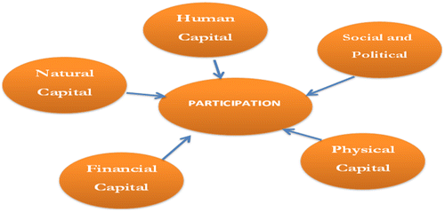
While the specific emphasis on participatory democracy has come from the left, it is also implicit in the liberalism of the right. Nozick, for example, envisages a framework in which people are “at liberty to join together voluntarily to pursue and attempt to realize their own vision of the good life in the ideal community but where no one can impose his (sic) own utopian vision upon others” (Nozick, Citation1974, p. 312) (Figure ).
Figure 1. Determinants of participation.
Source: Layson, Citation2014.
3. Research methodology
This section presents the research methodology. The focus is mainly on research design, strategy as well as the whole process by which the research was executed. It also includes tools for selecting, collecting, and analyzing data. Common research methods are quantitative, qualitative methods, or a mixture of both (Cavaye,Citation1996; Perry et al., Citation2002). The quantitative approach is sometimes referred to as traditional, the positivist, the experimental, or the empirical approach.
A desk review of relevant published and unpublished documents was assessed in order to gain understanding of the situation guiding the project and the process, and also to cross-validate the data collected from the other sources. The desk review assessed information from project documents, legislations, policy documents, strategies, action plans, performance reports, newspaper articles, and other relevant secondary documents. Different documents were reviewed as a source of evidence so as to get relevant information. Various books, journals, and reports on urbanization were reviewed.
As part of the sampling strategy for gathering data in the case study, a survey was carried out in both neighborhoods in Kariakoo area in Dar es Salaam, which involved written questionnaires with both closed as well as open-ended questions. Using a mix like this, it was hoped that the results from the questionnaires as well as the study as a whole would not become too reliant on empirical data (Drenscombe, Citation2007). Questionnaires are able to deal with value issues while at the same time leaving room for gathering quantitative data that can then be analyzed using statistical methods (Drenscombe, Citation2007). Purposive selection was used, based on the selection of information-rich cases for in depth study (Patton, Citation1990).
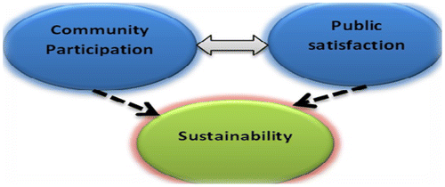
From the figure below, theoretically, it is hypothesized that there is a link between participation and satisfaction .The more the public participation, the more the public satisfaction, hence project sustainability is achieved, while assuming other factors are constant (Figure ).
Figure 2. Linkage between community participation, public satisfaction, and sustainability.
Source: created by the authors.
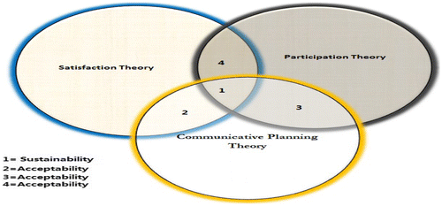
From the above assumptions, theoretically, when the community participates in the project, they can easily accept the project or reject the project. Access to information and understanding the decision-making processes is crucial in planning and planners need to include communication practices in their technical work in order to encourage community participation. When the community is involved in a project through participation, getting feedback as well as responding with views on how the project is going on, then the project is easily accepted or rejected. The acceptance of the project will influence participation and satisfaction. All these factors when integrated should assist with sustainability as shown in Figure below, which integrates theories to form a core value concept of sustainability. It is assumed that when the community is well informed about the project, then this can influence a high rate of participation due to acceptability (intersection 3). In addition to this, when the project is well understood by the community and the flow of information is clear, then this influences satisfaction due to acceptability (intersection 2). Moreover, satisfaction is highly influenced by participation due to acceptability (see Section 4 of Figure ). When the project is communicated well, participation may influence satisfaction hence sustainability (see Section 1, Figure below).
Figure 3. Conceptual theory on sustainability.
Source: created by the authors.
4. Background of the study area
“Dar es Salaam,” from the Arabic etymology, was founded as a “Haven of Peace” (sanctuary) in the Tanzania mainland by one of the feuding sons of the ruling Zanzibar Sultan as they contended for inheritance in Zanzibar in the 1860s.
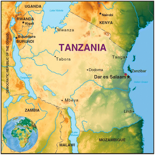
Dar es Salaam, “the abode of peace,” is the administrative center and the biggest city of Tanzania, though the capital city status was changed to Dodoma in 1974. Dar es Salaam contains 80% of the country’s industry. This is the third fastest growing city in Africa. It is divided into three municipalities which have their own local governments. These municipalities are Kinondoni in the north, Ilala in the center, and Temeke in the south. Dar Es Salaam is located close to the equator and by the coast of the warm Indian Ocean (Figure ).
Figure 4. Map of Tanzania showing location of Dar es Salaam.
Source: Layson, Citation2014.
The city began as a fishing village in the mid-nineteenth century, and is now Tanzania’s largest city, and has become one of East Africa’s most important ports and trading centers. Dar es Salaam is a prime example of a rapidly growing city in sub-Saharan Africa. In the most recent inter-census period from 2002 to 2012, population growth has been as rapid as ever. Dar es Salaam has experienced an absolute population increase of 1.9 million people, almost doubling its population from 2.5 million inhabitants in 2002 to 4, 364, 541 million in 2012. This translates into an average growth rate of 5.8% per year, which is significantly higher than in the two previous inter-census periods. It is also much faster than national population growth, which suggests that in-migration has been an important source of population growth (National Bureau of Statistics Tanzania Citation2006, Citation2013).
It is well documented that population growth in Dar es Salaam historically has translated into spatial expansion and residential sprawl, rendering the current transport system unable to cope with the spatial expansion of the city. The bulk of urban spatial expansion has happened in the form of informal settlements, often with little infrastructure in place (Figure ).
Figure 5. Map of Dar es Salaam showing districts and location of Kariakoo.
Source: Layson, Citation2014.
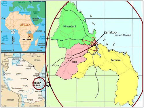
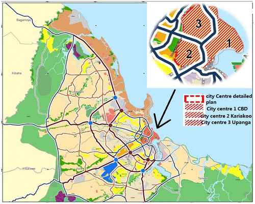
Figure 6. Location of Kariakoo in Dar es Salaam city.
Source: United Republic of Tanzania, Dar es Salaam master plan, 2012.
Urban transformations in Tanzania started during the German colonial period (1891–1920), followed by the British colonial government (1921–1961), which enforced Germany’s colonial urban rules and regulations by establishing the first Dar es Salaam master plan in 1949 followed by the Town and Country Planning Ordinance of United Republic of Tanzania (URT), Citation1956 and other policies to control land development in the urban areas. According to Kironde (Citation1994), the lands belonging to native Africans were pooled and traditional houses were demolished to pave the way for the construction of residential and commercial buildings for Europeans and Asians in low-density areas. According to Lupala Dar es Salaam, the town was divided into zones according to development zones as stipulated in the 1914 “Bauordnung” (Lupala, Citation2002, p. 42).
Basing on racial segregation principle, the Bauordnung defined the three development zones as follows: (i) Zone I was residential buildings for Europeans; (ii) Zone II was residential and trading building, mainly for Asians, and (iii) Zone III was for African, native quarters (Lupala, Citation2002). In this last zone, native buildings with flexible standards were allowed. As a result, the houses constructed were simple and traditional, typical of the African culture and “Swahili type of building” Kironde (Citation1994, p. 125). The British Government inherited the German planning system and maintained the status of Dar es Salaam.
4.1. Description of the case study
Kariakoo is a ward of the Ilala District of Dar es Salaam, Tanzania. It has an area of 1.96 km² and has an overnight resident population of approximately 50,000 people; the day population is estimated at 210,000. The name derives from a corruption of that of the British “Carrier Corps,” which used to be based in this area. Today, Kariakoo is mainly known for its extensive market, which spans several city blocks and contributes substantially to Dar es Salaam’s food provision as well as small-scale economy.
In pre-colonial times, there was a large village in the area now known as Kariakoo. This village was frequently raided by slave traders. In the latter half of the nineteenth century, the area became a shamba (farm) belonging to the Sultan of Zanzibar. During German rule, 200 hectares of the shamba were bought by a German businessman named Schoeller, who rented the land to the Africans. At the same time, Dar es Salaam began to grow, and while Europeans built their houses in exclusive areas such as Oyster Bay, Kariakoo became Dar’s main African settlement. In 1913, 15.000 out of the total 24.000 African inhabitants of Dar lived in Kariakoo.
Urban transformations in Tanzania started during Germany’s colonial period (1891–1920), followed by the British colonial government (1921–1961), which enforced the previous colonial urban rules and regulations by establishing the first Dar es Salaam master plan in 1949 followed by the enactment of Town and Country Planning Ordinance of 1956 to manage urban development. It is estimated that currently about 1 million of Dar es Salaam population, in one way or another find themselves in Kariakoo daily. The British who occupied the territory from 1919 to independence in 1961 maintained the settlement pattern. The Germans in their plan divided Dar es Salaam into three zones, I, II, and III (Figure ).
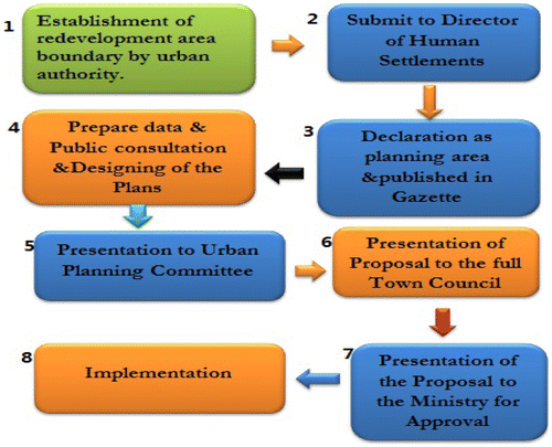
Figure 7. Procedures for preparation of urban renewal/redevelopment plans.
Source: author.
The allocation of the zones was based on race, allocating the bigger part, Zone I (along the harbor front and eastern part of the city) exclusively for European settlement and only European type of buildings were allowed; the central part of the town and Upanga as Zone II (where other buildings were also allowed, so long as they were built of solid materials and did not fall into the category of native huts) were to be occupied by Asians, in particular Indians; and the rest of Dar es Salaam to the periphery constituted Zone III (in which no types of buildings were specified, allowing room for construction of the simplest huts) to be occupied by the native Africans (Kironde,Citation1995, p. 130). In between Zone II and Zone III, a separating green belt was provided to serve as a buffer or a filter through which the native Africans had to go through in order to enter the town center. Over time, Zone I was extended to include Oyster Bay and Masaki to the northeastern part along the beach and to the harbor front.
Characteristically, Zone I was characterized by large plot layouts that formed low-density residential types. Zone II layouts were usually of medium-density plot sizes producing medium-density residential types, while Zone III was characterized by small plot layouts that produced high-density residential areas for the natives and/ or low-income groups. The African residential zone to the west of Dar es Salaam was initially limited to Kariakoo and was further extended to include Ilala in the 1930s (Kironde, Citation1995). After the British takeover of Tanganyika in 1919, planning separated or segregated residential areas and the segregation of residential areas was later taken on board as the planning instrument. This policy existed until independence in 1961:
While segregation is usually presented in the context of health and differential standards of living, it is also important to see it as a tool of domination. It is in the rarest of social organizations that ruler and ruled mingle together. Usually, the rulers segregate themselves, and are able thereby, to physically and ideologically domineer upon the ruled. (Kironde, Citation1995, p. 125)
The Colonialists zoned and created the government area, which was essentially for Europeans; the commercial area was partly for Europeans but mainly for Indians; and the urban village was mainly for native Africans.
4.2. Overview of Tanzania’s urban planning process and system after independence
4.2.1. Introduction
Soon after independence, that is, from 1961 to 1980, Tanzania like many other developing countries set out ambitious social and human resources development plans, including programs generally aimed at the eradication of poverty, ignorance, and diseases over two decades. In 1967, Tanzania adopted the top-down policies (Arusha declaration) and in 1972, Tanzania introduced a decentralization policy. In Swahili, “madaraka Mikoani” means giving powers to the local governments; this focused on decentralizing key authorities and functions of government from the center to the grass-roots level, so as to enable the community to participate in decision-making (URT, Citation2000).
The most important intended links between local government and the residents of the given area are the Vitongojis (subwards) in the rural areas and the urban Mtaa committees (subward committees), which are designed to mobilize citizen participation in local development.
In addition to the above, citizen participation in local government decision-making is encouraged by the amendments to the Local Government (District Authorities) Act 1982, which provide for councils to organize public hearings for people to question political leaders and staff. Councils have also been empowered to establish special kinds of service boards, open to all citizens in the area and providing an opportunity to influence service provision. Participatory budget-making has also become a means to increase resident participation. It is currently enabled by the bottom-up budgeting through the ward development committees and the democratic structures above them.
For urban planning, after independence in 1961, the Tanzania Government copied and modified the British planning system. Colonial zones were categorized as Zone I (low-density areas), Zone II (medium-density areas), and Zone III (high-density areas). These differences were also in sizes: Zone I is characterized by large areas, compared with zone II whose areas are medium-sized, while Zone III has small areas. Zone I is planned for high-income earners, Zone II for medium-income earners, and Zone III for low-income earners.
The legal basis for urban planning in Tanzania after independence (Citation1961) was the Town and Country Planning Ordinance (Capacity 378) of 1956 as amended in 1961. This ordinance was supported by subsidiary legislation such as the Local Government (Urban Authorities) Act No. 8 of 1982, as amended in 2002, which gives power for urban authorities to prepare detailed planning schemes and submit these to the Minister responsible for local governments for approval, and the Land Act No. 4 of 1999, as amended in 2004. Sites for residential development in Tanzania are usually designated in master plans or strategic urban development plans (SUDP) for large- and medium-sized cities and interim land use plans for small towns. The urban councils (local authorities) are preparatory authorities responsible for preparing detailed schemes commonly referred to as layout plans, subdivisions plans, or town planning (TP) drawings of the area designated in the master plans, SUDP, or interim land use plans. Town planning drawings are prepared by the respective local council and approved by the Ministry of Lands Housing and Human Settlement Development. The Ministry participates in the designing and preparation of layouts only when a particular council seeks assistance. The Town and Country Planning Ordinance (Capacity 378) of 1956 was amended in 1961 after the parliament enacted Urban Planning Act no 8 of 2007. Section 19(1b) of the Urban Planning Act (2007) calls for participation of all stakeholders including landowners, public and private institutions, community-based organizations, and non-governmental organizations in the area to be affected by the plan.
4.2.2. Preparation process of redevelopment/urban renewal
With assistance of Ministry of Lands, the urban councils (local authorities) are preparatory authorities responsible for preparing urban regeneration plans. The following is a summary of the procedures followed by local councils in the preparation of urban renewal/redevelopment plans (Figure ).
| (a) | Establishment of redevelopment area boundary. This is carried out by the respective planning authority (urban council), defining the boundary and preparing a map of the area. Approval of the proposed boundaries is by the full council of the respective town/municipal or city. | ||||
| (b) | Submission of the approved proposal to the Director of Human Settlements This involves publishing of proposals in the government gazette as an area for preparation of a redevelopment scheme. Section 34 of the Land Acquisition Act (1967) Cap 118s empowers the Minister for Lands to declare a scheme of redevelopment. Where the Minister declares any area to be a redevelopment area, he must cause the area to be defined on a map and he must cause copies of the map to be exhibited at the offices of the local government authority within whose jurisdiction the redevelopment area or any part thereof is situated. Subject to such declaration, he may advice the President where necessary to acquire land, for the areas requiring redevelopment in urban areas. In the case of redevelopment, all interests in or over land within the redevelopment area, once acquired, become extinguished. Upon such declaration of redevelopment schemes, residents of the area whose buildings were of acceptable quality will be deemed to have a valid right in the area. Other residents will have to apply for rights of occupancy as developers under the new terms and conditions. In that case, the law has empowered the Minister to grant to every development owner within the redevelopment area, a right of occupancy over the land on which an acceptable building is situated. The development owner is further deemed to hold a right of occupancy over such land on such terms as the Minister may by order prescribe until the time the grant is made. Moreover, according to Section 8(3) of the Urban Planning Act (2007) Cap 355, the process for the declaration of the planning area requires (a) a favorable response at a public hearing or in the area, conducted by the planning authority; (b) a resolution by planning authority recommending the declaration of planning area; and (c) a positive recommendation by the Regional Secretariat of the respective region. | ||||
| (c) | Preparation of base maps and collection of socioeconomic data for planning purposes. After the declaration of the planning area, the relevant planning authorities may prepare general and detailed schemes of development. The schemes must adhere to legally established procedures. | ||||
| (d) | Presentation of a first draft report showing the existing situation of buildings, land uses, and infrastructure to the Urban Planning Committee (UPC) for comments and recommendation on how they would like their central area to be redeveloped. | ||||
| (e) | Presentation of the proposed redevelopment plan to the full council for approval. The full council consists of ward representatives (neighborhood). These are elected representatives by their respective neighborhoods. | ||||
| (f) | Presentation of the proposed redevelopment plan to the Minister for Lands and Human Settlement Development for authorization. | ||||
| (g) | Distribution of copies of the authorized plan to the respective council and other stakeholders for implementation. | ||||
Figure 8. Assessing demand for project initiation.
4.3. Respondent profile
The study interviewed a total of 292 respondents of which 57.53% were males and 42.47% were females. The study shows that 42.5% reside in the area, while 27.4% lived and worked in Kariakoo and the rest just worked in the area. In the study, 68.49% of the interviewed people were tenants, while 28.77% were house owners. Moreover, 2.74% were not educated, while 39.73% were primary education leavers and 38.36% were secondary education leavers. Only 18.71% had completed college education and 1.37% were university graduates (Table ).
Table 1. Cross-tabulation of tenure status with gender.
The study shows that about 63.0% of the respondents had lived in Kariakoo for more than 10 years, and 26% had lived between 1 and 10 years, while only 11% had lived less or equal to 5 years (Table ).
Table 2. Duration of respondents residing in the area.
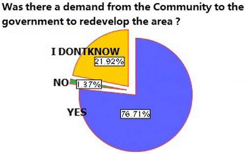
Moreover, residents were assessed as to whether they considered that efforts for the redevelopment of Kariakoo were initiated by themselves or the government. The study shows that Kariakoo residents initiated the idea for redeveloping the area through community meetings; this is evidenced by 76.71% of the respondents who agreed that the community initiated the need for redevelopment as shown in Figure .
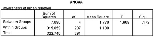
Figure 9. ANOVA, comparison on level of education and awareness.
4.4. Awareness of the urban redevelopment program
The participation of the residents in the redevelopment projects depends on many factors, some of them are internal (motivation, understanding, and capability/capacity), and some are external (government regulations and restrictions, cultural attitudes, etc.). Information, communication, and cooperation are the basics of effective and transparent public participation. The Kariakoo Community was assessed on their awareness of the redevelopment program. The study revealed that the majority were not aware of what was going during the preparation of the plan. This is evidenced by the fact that only 8.2% of those interviewed were familiar, while 43.8% responded that they heard about the project, and 28.8% had never heard about the redevelopment, as shown in the table below. Moreover, only 22.6% of the respondents participated in the project (Table ).
Table 3. Respondents’ awareness of Kariakoo urban redevelopment.
Awareness of Kariakoo urban redevelopment
The majority claimed that they discussed the issue of redevelopment, but they were not aware whether their ideas were addressed or not. However, these claims from the community might be influenced by the level of education – as explained above the majority have low levels of education in analyzing technical issues. This is evidenced by 19.2% of respondents who were not sure of the question. Analysis of variance (ANOVA) was tested to compare level of awareness and level of education. This aimed at testing the differences between means on variables (awareness of urban renewal and level of education) (Figure ).
Figure 10. Correlation between level of education and awareness on urban renewal/redevelopment.
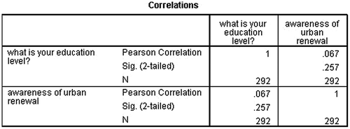
For this case, the results show that at a 95% confidence interval, there is no statistical significance between the level of education and awareness because level of significance (p = 0.172) is greater than 0.05. Similar results were obtained after correlating between levels of education and awareness. The results show that there is no statistical correlation between the level of education and awareness of urban redevelopment/renewal in Kariakoo as shown in the table below (Figure ).
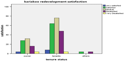
Figure 11. Satisfaction assessment based on housing ownership.
4.5. Factors that influenced the participation process in the Kariakoo redevelopment plan
There are several problems that have hindered community participation in Kariakoo redevelopment plan and which must be avoided in order for future projects to be successful in Kariakoo and Dar es Salaam, as follows:
| (1) | Lack of clear objectives linking the short- and long-term visions of the program and the redevelopment plan, and | ||||
| (2) | Lack of pilot projects with extensive training programs or lead-in time to allow for proper planning. | ||||
| (3) | Lack of commitment from other community members. | ||||
| (4) | Poor communication regarding the community participation process, leading to poor meeting attendance; as the results revealed, the majority of interviewed people (80.82%) were not aware of the project. The results revealed that 43.84% got information through community meetings and 24.6% got the information about the project through community leaders, thus there is a need to fully involve community leaders in educating people about the project to enable them to participate fully. | ||||
| (5) | Unequal level of education of facilitators and participants. The majority of the participants had a low education level; as the study revealed, more than 80% were below college level. They needed clear and intensive training about the program and their roles in making the program and projects successful. | ||||
4.6. Community perceptions on satisfaction in Kariakoo Redevelopment
A questionnaire survey on public satisfaction on the Kariakoo redevelopment was aimed to assess different aspects such as the environmental aspect, the satisfaction with public services such as infrastructure and with services such as education, water supply, electricity, telecommunications, etc. After processing the data-sets via SPSS, the empirical results revealed that the involvement of the private sector (telecommunication industry) shows a positive impact to the community. The study shows that 60.27% of the respondents were satisfied with telecommunications services in the redeveloped area and only 4.11% were very dissatisfied. In addition to this, the research revealed that in the issue of water supply, about 1.37% were very satisfied, while 20.55% were satisfied with the Kariakoo redevelopment. However, there was a high rate of dissatisfaction with water supply improvement. This was due to the fact that the proposals for improvement were not implemented as proposed and the high population growth of Kariakoo with limited water infrastructure made the situation worse. In addition to this, in relation to road improvements, 2.74 and 23.29% of the respondents were very satisfied and satisfied, respectively. The high rate of satisfaction is due to the improvement of roads; since the majority of Kariakoo roads are under Tanzania Road Agency TANROAD funds, thus there is fund for routine maintenance from municipality and TANROAD (Figure ).
Figure 12. Cross-tabulation of project satisfaction and participation.
When housing ownership was disaggregated on a gender basis, the ANOVA shows that at a 95% confidence interval, the result is statistically significant at the level of significance of 0.049. Since the significance value is less than 0.05, we can conclude that there is a statistically significant difference between tenure status and gender.
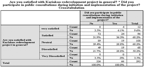
The study shows that there is a significance relationship between satisfaction and the participation. The research shows that 3.5% of those who did not participate were very satisfied with the redevelopment project, while 6.1% of those who participated were very satisfied with the redevelopment. There was no big difference on the level of dissatisfaction between those who participated and those who did not. There was no big difference in the issue of satisfaction, as the results show that 31.9% of those who did not participate were satisfied compared to 36.3% of those who participate, as the table below shows (Figure ).
Figure 13. A graph of relation between participation and satisfaction.
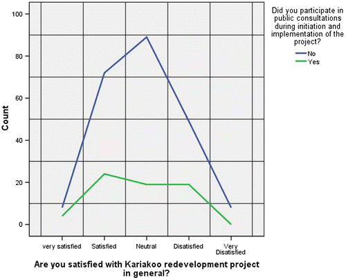
The graph below was drawn using SPSS to assess relation between participation and satisfaction. From the figure below, there is no positive relation between participation and satisfaction (Figure ).
Figure 14. Correlation between participation and awareness on urban renewal/redevelopment.
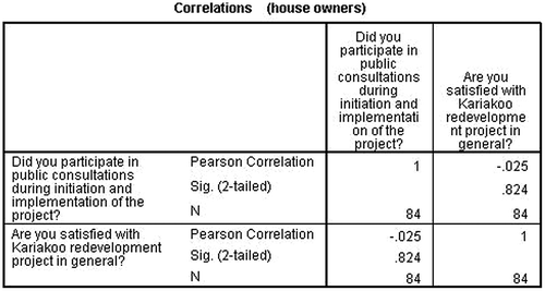
From the Pearson r correlation coefficient using SPSS, the results show that the actual Pearson correlation is statistically significant at –.044. This means the relationship is negative. From the interpretation of the results, it shows that for this case, there is little negative relationship between participation and satisfaction when considering the whole sample of 292 respondents. It may be concluded that there is no relationship between participation and satisfaction. The same question was analyzed by taking samples of house owners only.
A cross-tabulation of participation of house owners and satisfaction was studied and analyzed. This was retrieved from a sample population of 292 and analyzed owners only (84). The results show that for the case of house owners, there is no relationship between participation and satisfaction, as the table above indicates. A similar test was done by correlating the house owners alone (N = 84), comparing participation and satisfaction, and the Pearson correlation shows that results have no positive correlation between participation and satisfaction as the table below indicates (Figure ).
Moreover, 19.0% of the owners who did not participate were satisfied with redevelopment, while 14.3% were satisfied though they did not participate. This might be caused by the low level of knowledge of the redevelopment process and the long process of preparation of the plan which took 4 years of preparation since 1998 and was completed in 2002. This was due to the low government budget allocated for completion of the task.
5. Conclusion
The results above indicate that participation in urban redevelopment does not significantly influence levels of satisfaction. Moreover, guidelines for community involvement are not clear. The emphasis is on public hearing and consultations. However, consultation does not ensure that the community views must be taken and be part of decision-making. The chance for community views to be accommodated in the planning process is too low. Based on procedures for the preparation of redevelopment plans, the land laws give the Minister of Lands too much power in the management of land use. Less power is given to the land owners. The Minister may revoke titles whenever he/she feels the necessity to do so according to what is regarded as “public interest.” The affected group/residents give their opinions as some consultative meetings. However, the public consultations and the samples of representation are unclear, and not sufficiently stipulated in urban planning regulations. Poor communication regarding the community participation process leads to poor meeting attendance as evidenced by the results that majority of interviewed people (80.82%) were not aware of the project. The levels of awareness influence the participation as described in Figure above. The results revealed that 43.84% got information through community meetings and 24.6% got the information about the project through community leaders; thus there is a need to fully involve community leaders in educating people about the project, to enable them to participate fully.
The planning system during the colonial period was a top-down approach. The zoning system was ordered by the government accompanied with forced eviction without compensations. Following independence, the government adopted the colonial system of planning until 2007 when a new act was established (Urban Planning Act, 2007). Section 19(1b) of the Urban Planning Act calls for participation of all stakeholders including landowners, public and private institutions, community-based organizations, and non-governmental organizations in the area to be affected by the plan. The Kariakoo redevelopment was prepared in 2002, thus the Urban Planning Act came later. Tenants’ views and opinions are normally ignored during the planning process, even though they are among the important stakeholders positively affected by the proposed plans.
The study also found that many residents have mixed feelings about the impacts of the Kariakoo redevelopment on their physical residential environment. The redevelopment inevitably caused social disturbance for many residents, particularly for the disadvantaged people (low-income residents) who were tenants. The majority of tenants claimed that they lost their friendly neighbors after change from residential to commercial uses.
Clearly, therefore, a gap exists between the public service that is provided (social and physical infrastructures) and the perceptions on the services provided (to Kariakoo residents). Reducing this gap requires far greater concern to be given to for individual perceptions and the quality of service. The involvement of the community in deciding its future is crucial for sustainability. Without the community being involved, its requirements and needs may easily be ignored by policy-makers in the decision-making process. Decision-makers may think they understand the needs of the community well, but actually they may not. For instance, the telecommunication services show a high satisfaction among residents compared to other services, due to the involvement of private stakeholders in the telecommunication industry. Moreover, while a high level of participation results in a high level of satisfaction in some aspects of public service delivery, it is not necessarily the case that the high level of satisfaction results from participation in the project, as shown by the evidence above.
Disclosure statement
No potential conflict of interest was reported by the authors.
References
- Cavaye, A. L. M. (1996). Case study research: A multi-faceted research approach for IS. Information Systems Journal, 6, 227–242.10.1111/j.1365-2575.1996.tb00015.x
- Drenscombe, M. (2007). The good research guide (2nd ed.). New York, NY: McGraw-Hill International.
- Gramsci, A. (1971). Selections from the prison notebooks. (eds. Q. Hoare & G. Nowell Smith). London: Lawrence and Wishart.
- Hart, K. (2010). Chapter 20. Africa’s urban revolution and the informal economy. In V. Padayachee (Ed.), The political economy of Africa (pp. 371–388). London: Routledge.
- Held, D. (1987). Models of democracy. Cambridge: Polity Press. Retrieved from: http://www.un.org/esa/sustdev/documents/agenda21/english/agenda21toc.htm
- Jessop, B. (1997). A neo-Gramscian approach to the regulation of urban regimes: Accumulation strategies, hegemonic projects, and governance. In M. Lauria (Ed.), Reconstructing urban regime theory: Regulating urban politics in a global economy (pp. 51–75). Thousand Oaks, CA: Sage.
- Kironde L. (1994). The evolution of land use structure of Dar es Salaam 1980–1990, a study in the effects of land policy (PhD dissertation). Faculty of Architecture, Design and Development, University of Nairobi, Nairobi.
- Kironde, J. M. (1995). Access to land by the urban poor in Tanzania: Some findings from Dar es Salaam. Environment and Urbanization, 7, 77–96.10.1177/095624789500700111
- Kulsrisombat, N. (2008). De Facto urban regeneration: A case study of Chiang Mai City, Thailand in sustainable city regions: Space, place and governance. In T. Kidokoro, N. Harata, L. P. Subanu, J. Jessen, A. Motte, & E. P. Seltzer (Eds.), cSUR-UT Series: Library for sustainable urban regeneration (Vol. 7). Tokyo.
- Lane M. B. (2003). Participation, decentralization, and civil society: Indigenous rights and democracy in environmental. Journal of Planning Education and Research. 22, 360–373.
- Lane, M. B. (2006). The role of planning in achieving indigenous land justice and community goals. Land Use Policy. 23, 385–394.
- Layson, J. P. (2014). Integrating community participation in urban redevelopment projects: The case of Makongo in Dar es Salaam Tanzania. Civil and Environmental Research, 6, 27–35.
- Lin, C.-Y., & Hsing, W.-C. (2009). Culture-led urban regeneration and community mobilisation: The case of the Taipei Bao-an Temple Area, Taiwan. Urban Studies, 46, 1317–1342.10.1177/0042098009104568
- Lupala, J. (2002). Urban types in rapidly urbanising cities: Analysis of formal and informal settlements in Dar es Salaam. Stockholm: KTH.
- Munro-Clarke, M. (Ed.). (1992). Citizen participation in government. Sydney: Hale & Ironmonger.
- National Bureau of Statistics Tanzania, N. (2006). Tanzania census 2002 analytical report (Vol. X). Dar es Salaam: URT.
- National Bureau of Statistics Tanzania, N. (2013). 2012 Population and housing census. Population distribution by administrative areas. Dar es Salaam: URT
- Neto, P., & Serrano M. M. (2011). Governance and creativity on urban regeneration processes. CEFAGE-UE Working Paper 2011/07.
- Nozick, R. (1974). Anarchy, state, and Utopia. New York, NY: Basic Books.
- Patton, M. Q. (1990). Qualitative evaluation and research methods (2nd ed.). Newbury Park, CA: Sage.
- Perry, J. N., Liebhold, A. M., Rosenberg, M. S., Dungan, J., Miriti, M., Jakomulska, A., & Citron-Pousty, S. (2002). Illustration and guidelines for selecting statistical methods for quantifying spatial patterns in ecological data. Ecography, 25, 578–600.10.1034/j.1600-0587.2002.250507.x
- Roberts, P., & Skyes, H. (2000). Urban regeneration: A handbook. London: Sage.
- Simon, R. (1991). Gramsci’s political thought: An introduction. London: Lawrence & Wishart.
- SSATP. (2010). A study of institutional, financial and regulatory frameworks for urban transport in large Sub-Saharan African cities. Sydney: SSATP.
- United Nations (1992a). Report of the United Nations conference on environment and development, annex I: Rio declaration on environment and development. Retrieved from: http://www.un.org/documents/ga/conf151/aconf15126-1annex1.htm
- United Nations. (1992b). Agenda 21, Rio declaration, forest principles. New York, NY: Author.
- United Republic of Tanzania (URT). (1956). Town and country planning ordinance-cap 378. Revised in 1961. Dar Es Salaam: Government Printer.
- URT. (2000). Legal Framework for implementation of the government policy on decentralization by devolution. Dar Es Salaam: Government Printer.
- Webber, M., & Crooks, M. L. (Eds.). (1996). Putting the people last: Government, services and rights in Victoria. Melbourne: Hyland House.