
Abstract
South Africa’s history prior to the 1990s was one of racial division in all areas of life. To investigate the spatial extent of racial integration since the dismantling of apartheid in the early 1990s, population distribution by race across the Gauteng City-Region was mapped at a ward boundary level using the national 2011 Census, where one dot on the map represents 100 people. While racial segregation is still evident at a regional scale, there has been a gradual mixing of races at a residential suburb level in a number of historically coloured, Indian and white-only suburbs. In contrast, townships such as Soweto and the previous homeland areas of north-western Gauteng remain predominantly black. Although some progress has been made, generations of change are still required to achieve a spatially integrated society in South Africa.
South Africa’s history prior to the 1990s was one of racial division in all areas of life. The graphic shown in Figure represents a visualization of racial integration in Gauteng-City Region (GCR) since the dismantling of apartheid in the early 1990s, measured by where people live. Located in the central north-east of South Africa, the heart of the city-region is Gauteng province – home to 24% of South Africa’s population (12.2 million). Gauteng is the economic powerhouse of the South African economy with the province contributing 34% of national gross value added (GVA) and wider city-region accounting for 42% (Gauteng City-Region Observatory (GCRO), Citation2011).
Figure 1. Racial integration in the Gauteng-City Region (GCR).
Source: Statistics South Africa: 2011 Census, Municipal Demarcation Board. Software: Esri ArcGis 10.
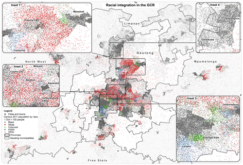
To investigate the spatial extent of racial integration, population distribution by race across the GCR was mapped at a ward boundary level using the national 2011 Census. In the South African context, wards refer to the spatial delineation of political administrative boundaries within local municipalities, with a total of 508 wards in the Gauteng province delineated for the 2011 local (municipal) elections. The total number of each race group per ward was mapped using the dot density option within Arcmap, where one dot on the map represents 100 people. The apartheid racial divide is still clearly visible in the main map with the white population (indicated by red dots) largely at the core of the central urban form, surrounded by clusters of black (grey), coloured (green) and Indian (blue) population living on the outer fringes.
While division is still evident, there has been a gradual mixing of races. Between 1991 and 2011 residential segregation has decreased in the City of Johannesburg (Parry, Citation2013). A more diverse racial mix is evident in the traditionally white northern suburbs of the City of Johannesburg centred around Sandton (inset 2) – areas of middle to high suburban house prices, indicative of an emerging black, coloured and Indian middle class. The recently developed mixed-income, mixed-race housing development of Cosmo City contrasts against the historical low-income black township of Alexandra (established in 1912), which remains predominately black. The racial distribution of former apartheid townships previously designated for the black, Indian and coloured population, such as Soweto, Lenasia and Eldorado Park, are shown in inset 3. Some integration is evident, especially in the suburbs south of the Johannesburg central business district (CBD), but to a lesser degree in Soweto which remains predominantly black. A lack of integration is especially prevalent in the north-west of Gauteng (inset 4), where massive new low-cost housing developments have occurred on the fringes, far from economic opportunities in the central areas of the GCR, thus perpetuating the apartheid form.
Although Figure illustrates a gradual mixing of races at a suburb level, on a city-regional scale residential settlements remain split along a racial divide which will require generations to change.
Acknowledgements
Gauteng City-Region Observatory (GCRO) is a partnership between the University of Johannesburg, the University of the Witwatersrand, Johannesburg, and the Gauteng Provincial Government, Johannesburg, South Africa. The author wishes to thank Kavesha Damon for assisting with the initial data preparation.
Related Research Data
References
- Gauteng City-Region Observatory (GCRO) (2011). State of the city-region review. Johannesburg: GCRO.
- Parry, K. (2013, September). Measuring racial segregation at different geographic scales in Cape Town and Johannesburg 1991–2011. Paper presented at the Gauteng ISIbalo Symposium 2013, Pretoria, South Africa.