
Abstract
Floodplain areas across the world have always played an attractive role for residential and non-residential developments. The Alpine regions have a strong pressure to develop new residential and non-residential buildings in hazard areas due to lack of other areas suitable for development. Consequently, the number of elements at risk and vulnerability to flood hazards increased. In order to reduce the vulnerability, the focus of mitigation flood hazards was for decades on structural engineering measures with the problem of spatial misfits between the threat and management strategy. Since the late 1990s/early 2000s, Austrian policy makers have been trying to overcome this spatial misfit with the implementation of an inter-local co-operation approach with the use of so-called ‘new spatial planning’ (Heley, 2013) in the planning process. Therefore, the paper examines what the actors and stakeholders are doing in practice and how the concept of fuzziness helps. Although a partnership approach may be seen as a promising solution, in practice there are many limitations and barriers in establishing these collaborations and making them effective (especially in the long term). Rhetoric may not be matched by reality and a ‘partnership’ agenda may bring more problems (i.e. high transactions costs, high risk of failure, uncertainty in the long term) than it solves.
Introduction
Floodplain areas across the world have always been attractive for residential and non-residential developments. Regions (such as Alpine floodplains) lacking other suitable development areas face strong pressure to develop buildings in hazard areas. Both policy-makers and researchers focused upon questions of reducing vulnerability to natural hazards against a current transformation in the state’s role in terms of responsibility sharing and individual responsibilities for risk management and precaution. Traditional flood-risk management approaches envisage implementing engineering solutions within local authority boundaries: local municipalities use their territorial power to restrict land use and build/compel flood defence schemes (Hartmann, Citation2011; Thaler, Citation2014).
However, with flood events not stopping at administrative borders, traditional approaches suffer from a spatial misfit between threats and flood risk-management strategies. A new policy approach is emerging where national, regional and local levels all play some role in managing flood-risk management and collaborating to safeguard natural storage capacities by restoring/enhancing the natural features and characteristics of wetlands, rivers and floodplains (Thaler, Citation2014): catchment-wideFootnote1 management plans may encompass measures from upland forestry to river restoration, alongside floodplain interventions with storage reservoir implementation and agricultural practice changes (Ayre & Nettle, Citation2015; Thaler, Priest, & Fuchs, Citation2016).
A proliferation of new concepts and approaches have emerged concerning these emerging catchment-wide managements, here highlighting two that allow a rethinking of time, stakeholders or policy fields in the planning processes (Sielker, Citation2016). Firstly, the emergence of new kinds of interaction boundaries (fuzzy boundaries) faced by those planning and managing integrated catchment planning (Allmendinger & Haughton, Citation2009; Heley, Citation2013; Metzger & Schmitt, Citation2012). Secondly, new institutional arrangements necessary to allow implementation flexibility. According to Haughton, Allmendinger, Counsell, and Vigar (Citation2010) these two new planning concepts (soft spaces and fuzzy boundaries) produce ‘new opportunities for creative thinking, especially in areas where public engagement and cross-sectoral consultation has seen entrenched oppositional forces either slowing down or freezing out most forms of new development’ (p. 52). Formal institutional settings’ shortcomings are addressed via the transfer of power and responsibility from local authorities, thereby involving new actors or stakeholders in decision-making, and creating new ‘sub-regions’ outside ‘hard’ political boundaries (Allmendinger & Haughton, Citation2009, Citation2010; Haughton, Allmendinger, & Oosterlynck, Citation2013). These soft spaces and fuzzy boundaries supplement ‘hard’ political boundaries and decision-making processes, although they may also become formalized within political processes resulting in a hardening/formalization of these non-statutory planning approaches (Metzger & Schmitt, Citation2012).
This paper seeks to explore these processes in the context of flood-risk management, examining what actors and stakeholders are doing in practice and focusing on what the concept of fuzziness can reveal in terms of these process dynamics. Analysing stakeholders’ perspective highlights that these new planning practices encourage flexibility and creativity in regional and local decision-making processes. Further, the key advantage is the ability to adapt to local interests and objectives. The results indicate that catchment-wide management plans have a significant positive effect in increasing the sustainability in flood-risk management. Therefore, this paper asks two research questions:
| • | What roles do soft spaces and fuzzy boundaries play in shaping opportunities and barriers for partnership activities in flood-risk management, and what are their social and political functions and consequences in flood-risk management? | ||||
| • | How have fuzzy boundaries and soft spaces dynamics influenced national flood-risk management strategy? | ||||
THE ILL-WALGAU CASE STUDY
This paper uses a case study of the Austrian flood-risk management system, where flood-risk management shifted spatial focus from local flood-alleviation schemes towards a broader focus based on inter-local flood-risk management activities. Since the 1990s, Austrian flood-risk management policy emphasized using inter-local catchment-management plans to achieve holistic strategies for addressing particular flood hazard situations (Holub & Fuchs, Citation2009). With local authorities pressurized to reduce the spending alongside declining central resources, some have vaunted inter-local cooperation (engaging local authorities more strongly in decision-making processes) as a means to increase both available budgets’ ‘value’ and efficiency in using current public resources.
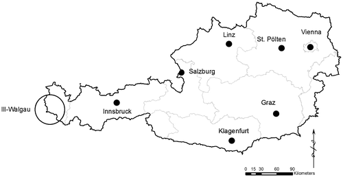
The case study (Figure ) covers the inter-local flood-risk management cooperation Ill-Walgau in the Austrian federal state of Vorarlberg, a high-pressure location where only 37.04% of the surface area is suitable for permanent settlement and associated economic activities (Statistics Austria, Citation2015). Ill-Walgau embodies a long tradition of riparian regulation, where upstream communities changed the river flow for agricultural and industrial developments.
Figure 1. Selected study site.
In the past 20 years the area suffered several flood events, most notably in summer 2005 where severe flooding affected western Austria (Salzburg, Tyrol and Vorarlberg) with substantial damage to commercial and private property alongside critical regional infrastructure (railway lines, highways and motorways). As a response to these flood events, the regional inter-local cooperation Ill-Walgau was established in 2010 with 20 members, including 12 local authorities, three infrastructure operators – the highway road authority (Asfinag), the national railways (ÖBB), the regional road authority (Landesstraßen) and five utility operators. Its overall objective is to implement inter-local flood-alleviation schemes to reduce overall catchment vulnerability, particularly downstream.
The inter-local cooperation approach has a number of differences from Austria’s traditional planning system, including:
| • | a more holistic view of the catchment, for example, by considering the different land-use patterns, social and political development and nature conservation; | ||||
| • | a whole-catchment focus; | ||||
| • | a risk-based approach; and | ||||
| • | a focus on future developments instead of the actual state. | ||||
The inter-local cooperation’s key task is organizing building flood defence measures between the inter-local cooperation and the local authorities. Therefore, inter-local cooperation is responsible for implementing inter-local flood defence measures, representing the key developer of the implementation of the catchment-management plan, for example, the design contracts with farmers to purchase the necessary land or design contracts with construction companies.
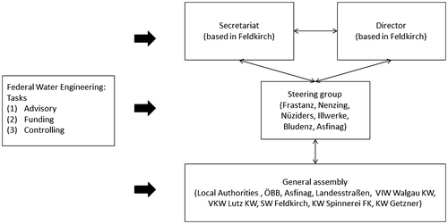
The inter-local cooperation’s structure can be characterized by a two-level structure: firstly, a general assembly and, secondly, a steering group (Figure ). The general assembly of members is the association’s highest board including all inter-local cooperation members, usually meeting twice annually to exchange information between members and discuss the overall strategy. The steering group is responsible for the implementation of the defined programme of measures intended to shift power and responsibility from the local level towards the steering group. Therefore, the formal decision-making competence is controlled and coordinated by the steering group and the Federal Water Engineering Administration. The steering group includes seven members (three permanent and four elected), mixing small and large members, being mainly responsible for the implementation, future maintenance and daily administration tasks.
Figure 2. Organizational and structural set-up in the Ill-Walgau study site.
The action plan include three key objectives:
| • | widening and sediment management of the river; | ||||
| • | returning the river banks to a natural state; and | ||||
| • | implementing five flood water storages in the catchment. | ||||
Local stakeholders are strongly involved in the planning, decision and implementation process of flood-risk management schemes. Organizationally, these are pooled in a management scheme, which is coordinated by the Federal Water Engineering Administration.
SOFT SPACES AND FUZZY BOUNDARIES IN THE ILL-WALGAU RIVER CATCHMENT AREA
A qualitative research design was used and primary and secondary data were collected to understand the practices of actors and stakeholders involved in creating new ‘sub-regions’ in the III-Walgau area. Eleven semi-structured interviews were conducted between February and May 2012 with actors and stakeholders from national, regional and local levels with different policy positions and backgrounds. The interviews were guided by a series of closed and open questions and took in general between 50 and 80 minutes, then transcribed and analysed using a grounded theory approach (Strauss & Corbin, Citation1998).
In the case study region, the ‘classical’ administrative flood-risk management approach was not able to respond to the actual developments and circumstances, and most notably the flood of 2005. Therefore, the Austrian flood-risk management policy change demanded a new ‘creative’ approach to the decision-making process with the consequence of new job descriptions for each actor in the cooperation. It is important to note that these changes happened informally. These new creative thinking processes encompassed two main areas, namely using new arrangements to encourage informal strategies to overcome time delays based on the formal planning processes; and secondly, to provide spaces for local initiatives to solve spatial planning conflicts in flood-risk management.
First, at the local scale we see the creation of new sub-regions outside the traditional political boundaries with the result of a new territorial thinking for the different involved actors and stakeholders – moving away from a local focus. These include a shift of responsibility and duties between national, regional and local bodies. This interaction of different stakeholders caused many conflicts and differences with the consequence that the Federal Water Engineering Administration redefined its job description with a stronger focus on project management and support and relationship building, communicating and problem solving instead of planning structural measures (Thaler & Levin-Keitel, Citation2016). These also influence the interaction and engagement between the different local actors and stakeholders. Therefore, we can conceptualize this as the use of fuzzy boundaries as a means of incorporating different stakeholders at local and regional levels to develop a common strategy in flood-risk management that could potentially represent a new space for emerging opportunities to develop inter-local (catchment-wide) flood-risk management plans (Allmendinger & Haughton, Citation2012).
Secondly, the stakeholders regarded the inter-local cooperation as a challenge due to new administrative practices and regulatory rules, often outside the formal legislation framework. A key motivation was that flood issues are not constrained by artificial borders, demanding inclusion of all relevant actors in the planning process as well as flexibility. Nevertheless, the local management plans must adapt to national and international strategies, and indeed in the Ill-Walgau example the local actors went a step further, incorporating these tiers into a single-level governance structure. We can interpret this as a policy process producing a meta-governance structure (Jessop, Citation2004) or a new ‘sub-region’ (Haughton & Allmendinger, Citation2008) to organize flood hazard aspects more efficiently.
Thirdly, all interviewees noted that the challenge of the introduction of new planning practices, and developing new sub-regions in organizing flood-risk management, involved a break from rigidly formalized regulation to facilitate tactical manoeuvres at the decision-making level (Allmendinger & Haughton, Citation2009). The new institutional spaces were mainly used in negotiation processes between the local municipalities and local land owners to change catchment-wide management plans. Consequently, the new spatial planning principles allowed the public administration a strongly pragmatic approach in the planning, decision and implementation stages. Interviews highlighted the importance of flexibility in the planning process, because of difficulties in building agreements between local land owners and local authorities. Ultimately, what emerged can be considered as ‘new spatial imaginaries’ – new identification platforms for policy-makers, stakeholders and citizens (Allmendinger & Haughton, Citation2010; Boudreau, Citation2007; Heley, Citation2013).
DISCUSSION AND CONCLUSIONS
Recent changes in the Austrian flood-risk management policy introduced a new discourse in the national flood-risk management policy system. With the introduction of a catchment-wide management approach, the inter-local cooperation was confronted with a mismatch between formally statutory planning and decision-making regulations and actually practical implementation of inter-local flood-risk management strategies. The results from the Ill-Walgau case study focus more on changes in the construction of boundaries and flexibility in the planning process.
Place identification was a key driver in the political mobilization of local actors with inter-local cooperation characterized by strong local attachment by local actors, stakeholders and citizens. Identification plays an important role for promoting financial contributions and support by local actors, where a key conflict was the contribution (e.g., land, financial) of each member in the cooperation. The consequence was a strong focus on ‘place-based’ flood-risk policy: different inter-local cooperations labelled themselves towards third actors to promote the cooperation, and used the inter-local cooperation as the official ‘branding’ name in communication processes (albeit with limited success).
Nevertheless, national authorities retained a central role in flood-risk management policy, with local authorities acting generally passively arguably arising from their lack of technical knowledge and experiences alongside limited interest. The inter-local cooperation primarily focused on operational implementation of the catchment management plan, for example, negotiation with farmers and signing contracts with construction companies. Local involvement in discussion and decision-making process depends upon local capacities for action, such as resources (knowledge, financial, time) and interest.
Further, a key problem within a cooperational approach was in shifting power to a steering group where ‘large’ local authorities were members, leaving ‘small’ members with less overall power in the decision. Founding the inter-local cooperation was very cost intensive and time consuming because the involvement of local stakeholders implies a longer negotiation process than in the case of individual local authority-based solutions.
Therefore, the new planning practices (use of soft spaces and fuzzy boundaries) can be understood in sum as a result and product from the actual flood-risk management policy in Europe. The key advantage in the use of fuzzy boundaries and soft spaces is the flexibility and the creation and development of new solutions capable of adapting to local circumstances. Consequently, the outcome is that the use of fuzzy boundaries and soft spaces play an important role in the actual flood-risk management discussion. Management plans also included concrete top-down management to provide discursive closure avoid endless discussion (Sielker, Citation2016), representing a process of ‘hardening’ of the catchment-wide boundaries (Haughton et al., Citation2013; Metzger & Schmitt, Citation2012), where different collaborations show a high degree of formalization between the different actors.
The results demonstrate that the use of approaches that constitute fuzzy boundaries and soft spaces show a tendency to ‘harden’ the space. ‘Hardened’ space were used as a political tool in the decision-making process where soft spaces and fuzzy boundaries are not only the result of the political process in the Austrian flood-risk management system (Allmendinger, Chilla, & Sielker, Citation2014). Consequently, use of fuzzy boundaries and soft spaces shows the potential to change flood-risk management towards more sustainability. In particular, the new spatial planning concepts encourage the use of green infrastructure (natural water retention resources) in flood-risk management.
ACKNOWLEDGMENTS
The authors thank Sabrina Lai and four anonymous reviewers for their valuable comments and suggestions made to an earlier version of this paper.
Additional information
Funding
Notes
1. A catchment basin (also called a drainage or watershed basin) is defined as the area that ‘refers to a drainage area in which surface water flows to a common outlet channel’ (Pulwarty, Citation2003, p. 865). I define river catchment, or drainage basin, as all land drained by a single river and its tributaries from the mountain to the seashore, with catchments separated by watersheds. The nature of a catchment and its activities (both human and natural) determine any river’s characteristics.
References
- Allmendinger, P. , & Haughton, G. (2012). Post-political spatial planning in England: A crisis of consensus? Transactions of the Institute of British Geographers , 37 , 89–103. 10.1111/j.1475-5661.2011.00468.x.
- Allmendinger, P. , Chilla, T. , & Sielker, F. (2014). Europeanizing territoriality – Towards soft spaces? Environment and Planning A , 46 , 2703–2717. 10.1068/a130037p.
- Allmendinger, P. , & Haughton, G. (2009). Soft spaces, fuzzy boundaries, and metagovernance: The new spatial planning in the thames gateway. Environment and Planning A , 41 , 617–633. 10.1068/a40208.
- Allmendinger, P. , & Haughton, G. (2010). Spatial planning, devolution, and new planning spaces. Environment and Planning C: Government and Policy , 28 , 803–818. 10.1068/c09163.
- Ayre, M. , & Nettle, R. (2015). Doing integration in catchment management research: Insights into a dynamic learning process. Environmental Science & Policy , 47 , 18–31. 10.1016/j.envsci.2014.10.011.
- Boudreau, J. A. (2007). Making new political spaces: Mobilising spatial imaginaries, instrumentalising spatial practices, and strategically using spatial tools. Environment and Planning A , 39 , 2593–2611. 10.1068/a39228.
- Hartmann, T. (2011). Clumsy floodplains: Responsive land policy for extreme floods . Farnham, Surrey: Ashgate.
- Haughton, G. , & Allmendinger, P. (2008). The soft spaces of local economic development. Local Economy , 23 , 138–148. 10.1080/02690940801976216.
- Haughton, G. , Allmendinger, P. , Counsell, D. , & Vigar, G. (2010). The new spatial planning: Territorial management with soft spaces and fuzzy boundaries . London: Taylor & Francis.
- Haughton, G. , Allmendinger, P. , & Oosterlynck, S. (2013). Spaces of neoliberal experimentation: Soft spaces, postpolitics, and neoliberal governmentality. Environment and Planning A , 45 , 217–234. 10.1068/a45121.
- Heley, J. (2013). Soft spaces, fuzzy boundaries and spatial governance in post-devolution wales. International Journal of Urban and Regional Research , 37 , 1325–1348. 10.1111/j.1468-2427.2012.01149.x.
- Holub, M. , & Fuchs, S. (2009). Mitigating mountain hazards in Austria – Legislation, risk transfer, and awareness building. Natural Hazards and Earth System Science , 9 , 523–537. 10.5194/nhess-9-523-2009.
- Jessop, B. (2004). Multi-level governance and multi-level metagovernance changes in the European Union as integral moments in the transformation and reorientation of contemporary statehood. In I. Bache , & M. Flinders (Eds.), Multi-level Governance (pp. 49–74). Oxford: Oxford University Press.10.1093/0199259259.001.0001
- Metzger, J. , & Schmitt, P. (2012). When soft spaces harden: The EU strategy for the Baltic Sea Region. Environment and Planning A , 44 , 263–280. 10.1068/a44188.
- Pulwarty, R. S. (2003). Transboundary river flow changes. In T. D. Potter , & B. R. Colman (Eds.), Handbook of weather, climate and water . Hoboken, New Jersey: Wiley-Interscience
- Sielker, F. (2016). New approaches in European governance? Perspectives of stakeholders in the Danube macro-region. Regional Studies Regional Science , 3 , 88–95. 10.1080/21681376.2015.1116957.
- Statistics Austria . (2015). Dauersiedlungsraum Abgrenzung 2011, Gebieststand 2014. Retrieved June 29, 2015, from http://www.statistik.at/web_de/klassifikationen/regionale_gliederungen/dauersiedlungsraum/index.html
- Strauss, A. , & Corbin, J. M. (1998). Basics of qualitative research: Techniques and procedures for developing grounded theory . Thousand Oaks: Sage
- Thaler, T. (2014). Developing partnership approaches for flood risk management: Implementation of inter-local co-operations in Austria. Water International , 39 , 1018–1029. 10.1080/02508060.2014.992720.
- Thaler, T. , & Levin-Keitel, M. (2016). Multi-level stakeholder engagement in flood risk management – A question of roles and power: Lessons from England. Environmental Science & Policy , 55 , 292–301. 10.1016/j.envsci.2015.04.007.
- Thaler, T. , Priest, S. , & Fuchs, S. (2016). Evolving inter-regional co-operation in flood risk management: Distances and types of partnership approaches in Austria. Regional Environmental Change , 16 , 841–853. 10.1007/s10113-015-0796-z.