
ABSTRACT
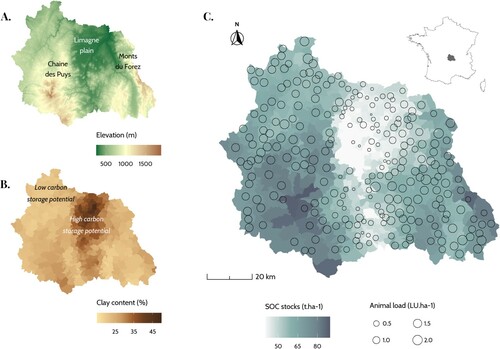
The ‘4 per 1000’ initiative aims to increase soil organic carbon stocks to offset carbon dioxide emissions. For a French case study, this graphic offers evidence of the links between carbon stocks and agricultural productions at the territorial level: stocks are positively associated with animal loads, whereas soils with arable crops have much lower stocks despite a higher storage potential. Territorial mapping of both storage capacities and organic resources is needed to optimize soil carbon storage.
KEYWORDS:
The ‘4 per 1000’ initiative aims to increase soil organic carbon (SOC) stocks by 0.4% per year to offset carbon dioxide emissions from human activities. Understanding the determinants explaining the distribution of current SOC stocks is an important step towards achieving this target. The Puy-de-Dôme departmentFootnote1 was chosen as a case study because of a wide diversity of soils and agricultural productions. The Limagne plain, specializing in arable crops, is surrounded by mountain ranges specializing in livestock breeding on grasslands.
Soil characteristics come from the SoilGrids projectFootnote2 (Hengl et al., Citation2017), statistical data from the French agricultural census (Agreste, Citation2010) and elevation from the French Digital Elevation Model BD ALTI ® (IGN, Citation1998). Animal load was calculated as the ratio of livestock units to total agricultural area at the municipality level. For municipalities where the herds were concentrated in a small number of farms, data on animal numbers were restricted to preserve anonymity and animal loads could not be calculated.
shows a clear difference in SOC stocks between the plain and the mountains, which can be partly related to agricultural productions. For the Limagne plain, it has already been shown that SOC stocks had decreased following the specialization in cereal production, which led to a reduction in manure spreading and the replacement of grassland with crops (Nowak et al., Citation2020). Consequently, it appears that there is a mismatch between potential SOC storage capacities and current stocks: while clay soils have the highest storage potential (Wiesmeier et al., Citation2019), they have the lowest stocks here. Beyond this case study, this trend can be observed in several territories, with the segregation of crop and livestock productions. Crops are mainly cultivated on soils with high storage potential, but with little organic input, such as manure. Mapping of both storage capacities and the available resources is a first step to optimize soil carbon storage. The territorial level is a key scale for carrying out such work because of the constraints related to the transportation of organic inputs.
Figure 1. (A) Elevation for the Puy-de-Dôme department in France; (B) clay content from 15–30 cm depth; and (c) soil organic carbon (SOC) stocks from 0 to 30 cm depth and animal load per municipality.
DISCLOSURE STATEMENT
No potential conflict of interest was reported by the author.
Notes
1 French departments are administrative entities of intermediate size, between municipalities and regions.
2 SoilGrids combines soil observations, remote sensing and machine learning to create digital soil maps.
REFERENCES
- Agreste. (2010). Recensement agricole 2010. http://agreste.agriculture.gouv.fr/recensement-agricole-2010/resultats-donnees-chiffrees/
- Hengl, T., Mendes de Jesus, J., Heuvelink, G. B. M., Ruiperez Gonzalez, M., Kilibarda, M., Blagotić, A., Shangguan, W., Wright, M. N., Geng, X., Bauer-Marschallinger, B., Guevara, M. A., Vargas, R., MacMillan, R. A., Batjes, N. H., Leenaars, J. G. B., Ribeiro, E., Wheeler, I., Mantel, S., Kempen, B., & Bond-Lamberty, B. (2017). Soilgrids250m: Global gridded soil information based on machine learning. PLoS ONE, 12(2), article e0169748. https://doi.org/https://doi.org/10.1371/journal.pone.0169748
- IGN. (1998). BD ALTI® 25 mètres. https://geoservices.ign.fr/documentation/diffusion/telechargement-donnees-libres.html#bd-alti-25-m
- Nowak, B., Marliac, G., & Hou, D. (2020). Optimization of carbon stock models to local conditions using farmers’ soil tests: A case study with AMGv2 for a cereal plain in central France. Soil Use and Management, 36(4), 633–645. https://doi.org/https://doi.org/10.1111/sum.12608
- Wiesmeier, M., Urbanski, L., Hobley, E., Lang, B., von Lützow, M., Marin-Spiotta, E., van Wesemael, B., Rabot, E., Ließ, M., Garcia-Franco, N., Wollschläger, U., Vogel, H.-J., & Kögel-Knabner, I. (2019). Soil organic carbon storage as a key function of soils - A review of drivers and indicators at various scales. Geoderma, 333, 149–162. https://doi.org/https://doi.org/10.1016/j.geoderma.2018.07.026