
ABSTRACT
The oceans cover roughly 2/3 of the Earth’s surface and are a fundamental ecosystem regulating climate, weather and representing a huge reservoir of biodiversity and natural resources . The preservation of the oceans is therefore not only relevant on an environmental perspective but also on an economical one. A sustainable approach is requested that cannot be simply achieved by improving technologies but calls for a shared new vision of common goods.Within such a complex and holistic problem, the role of satellite microwave remote sensing to observe marine ecosystem and to assist a sustainable development of human activities must be considered. In such a view the paper is meant. Accordingly, the key microwave sensor technologies are reviewed paying particular emphasis on those applications that can provide effective support to pursue some of the UN Sustainable Development Goals. Three meaningful sectors are showcased:oil and gas, where microwave sensors can provide continuous fine-resolution monitoring of critical infrastructures; renewable energy, where microwave satellite remote sensing allows supporting the management of offshore wind farms during both feasibility and operational stages; plastic pollution, where microwave technologies that exploit signals of opportunity offer large-scale monitoring capability to provide marine litter maps of the oceans.
Introduction
Earth’s surface is covered by oceans and seas for about 71% of its surface. The Pacific Ocean is the largest in extent (about 179 million km2), the second largest is the Atlantic Ocean (about 106 million km2) while the third largest is the Indian Ocean (about 73.5 million km2). These three oceans are separated by continents. In recent years, it has been identified the Southern Ocean (about 22 million km2), also known as Antarctic Ocean, that surrounds Antarctica and extends from the coast of Antarctica north to 40° south latitude. The ocean’s global circulation system plays a key role in distributing heat energy, regulating weather and climate, and cycling vital nutrients and gases. As an example, the irregular climate pattern describing the unusual warming of surface waters in the Eastern Pacific Ocean – at tropical latitudes – together with the local change in air pressure (Southern Oscillation) has a remarkable impact on ocean temperatures and currents, the health of coastal fisheries and local weather from Australia to South America and beyond. This well-known phenomenon is called El Niño. Density differences in ocean water drive the global conveyor belt. This global circulation system is also called thermohaline (thermo = temperature; haline = salinity) circulation (Mecklenburg et al., Citation2021; Rahmstorf, Citation2006). An associated phenomenon is the coastal polynya, a loanword from the Russian полынья that means an area of open water surrounded by sea ice (Nunziata et al., Citation2017; Smith & Barber, Citation2007). In summary, Oceans play a fundamental role in ruling the climate and the weather.
Oceans (and seas) are not only crucial for their environmental role but also as a source of economic growth and people prosperity. Such economical activities are given by the sum of the activities of the ocean-based industries, such as shipping, fishing, aquaculture, but even emergent activities as offshore wind, along with the assets, goods, and services of the sea ecosystem. Nowadays, offshore wind farms are growing and growing all over the world but especially in developed countries where the dependence from fossil fuels cannot be sustained by internal extractions. This is the energy counterpart of a well-assessed industry, the oil and gas one, that extracts about 30% of oil by offshore platforms. All extractive industries are prone to controversial debate on sustainability (Van Dover et al., Citation2017) but even industrial fisheries are on the spot. According to the UN (United Nations) Food and Agriculture Organization (FAO), in 2017, seafood accounted for 7% of all protein consumed globally and for about 17% of total animal protein. Fishing activities, traditionally done in coastal areas, have expanded now into the high seas and more than 30% of global fish stocks are considered overfished (FAO, Citation2020). This leads to an altered ecosystem and food chain, impacting local coastal populations who are dependent on these ecosystems. In general, the issue to be considered for each activity is the interrelationship among environment, health and economy. In modern terms, blue economy is referred to when the impact of such economical activities on the environment, and consequently on the heath, is considered and hopefully taken under control. Hence, “The blue economy concept seeks to promote economic growth, social inclusion, and the preservation or improvement of livelihoods while at the same time ensuring environmental sustainability of the oceans and coastal areas” (World Bank & United Nations Department of Economic and Social Affairs, Citation2017).
The ocean economy is relevant and diversified. According to (Rayner et al., Citation2019), it conservatively accounts for about US$ 1.5 trillion of global gross value-added economic activity and it is expected to double within 2030. In 2010, the number of direct full-time employment due to the ocean economy was estimated to be about 31 million jobs. The rapid expected growing pressure over the ocean ecosystem is per se a matter of concern but it is straightforward that it may hamper the ocean resources at the basis of such economical activities. Hence, the rational interest of all actors is to develop activities preserving the long-term environment in question.
Although such a rational goal sounds natural there are factors that generate great concern. Politically seas may belong to national states and therefore are ruled by national laws, but the greatest part are international waters (high seas) and, therefore, law definition is much more complex as well as its enforcement. The political difficulties are also witnessed by the fact that only since the 2015 COP (Conference of Parties) meetings have paid attention to oceans. At the recent 26th COP UN climate change conference in Glasgow, UK, only a round table was about oceans. While some steps have been made toward the sustainable use of oceans and especially high seas, see for example, the Biodiversity Beyond National Jurisdiction (UN resolution 72/249) of 2017 and follow on, there are strong economic interests such as deep seas mining which generates concern about sea biodiversity (Van Dover et al., Citation2017). It is important to underline that the different ocean economic sectors have different impacts (Rayner et al., Citation2019) and in each sector there are always activities of major and minor concern. Usually, the activities of major concerns are associated with large companies and politically more relevant countries. Further, independent observations are not always available and agreed (Rayner et al., Citation2019).
The matter of sustainability as a rational driver of economic actions is actually a matter that has promoted a strong contrast between different economic views. Although the reader can find ample literature in specialized economical journals it is here important to sketch the framework of such a debate in view of providing the reasonable expectations of the modern observation techniques that are detailed in the paper.
The milestone paper is the one by G. Hardin (Hardin, Citation1968), based on an earlier study of William Forster Lloyd (Lloyd, Citation1883), which describes the tragedy of “commons”, that is, of the goods, as oceans, which are unregulated and shared (not private properties). Since such kinds of resources are not accounted for in classical economic models they are known as externalities (Smith, Citation1776). The very essence of the study presented in (Hardin, Citation1968) can be summarized as follows: a finite world can support only a finite population and, in profound contrast with the economic theory of Adam Smith (Smith, Citation1776), the best individual choice does not lead at all to the optimum for the society as a whole. The first point implies the technical impossibility to have an always growing Gross Domestic Product (GDP) model while the second point means that the so-called A. Smith “invisible hand” is false. Although reference is here made to classical studies the reader is made aware that such Adam Smith theory “natural rules” are popularly taken for granted even nowadays. The criticisms of Hardin lead to a new economical approach that accounts for the externalities, such as the environment, and underlines that the preservation of the “commons” calls not only requires technical changes but a change on the human values and/or ideas of morality (Hardin, Citation1968). In modern words, sustainability calls for a holistic approach: abandoning commons to free riders we impoverish our society and a new set of agreed values must be considered. Nowadays, we are aware of all this and, according to Hardin, “the morality of an act is a function of the state of the system at the time it is performed” (Hardin, Citation1968). Accepting a limitation of our freedom is the only way to mitigate the tragedy of commons.
Once such values are shared the freedom limitation that is enforced can be monitored by satellite measurements (Nunziata et al., Citation2021). Earth observation is certainly an important tool of such a complex sustainable process as also witnessed by recent official documents (O’Connor et al., Citation2020). Within this framework this paper is to be meant. The remainder of the paper is organized as follows: in Section 2, an overview of the microwave satellite remote sensing techniques to support sea sustainability is presented. They are grouped in passive (see 2.1) and active (2.2) technologies. In Section 3, the added-value provided by spaceborne microwave sensors to pursue the Un SDGs is discussed. Conclusions are drawn in Section 4.
Microwave satellite remote sensing
Space-borne microwave remote sensing instruments can be divided into two broad categories: passive and active sensors.
Passive sensors
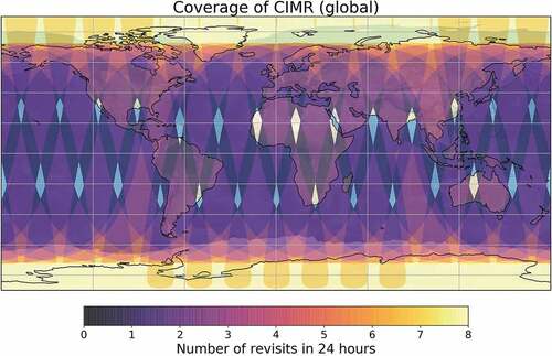
The reference passive microwave sensor is the Microwave Radiometer (MWR), a sensor that measures the radiation naturally emitted by the Earth surface at different frequencies and polarizations. The MWR measurements over sea are combined to generate added-value products of relevance for marine monitoring such as Sea Surface Temperature (SST), Sea Surface Salinity (SSS), the extent and concentration of sea ice cover (SIC), the wind speed and the rain rate over the ocean (Emery & Camps, Citation2017). The importance of MWRs in the context of sustainability is further highlighted by the recent approval of the Copernicus Imaging Microwave Radiometer (CIMR; Vanin et al., Citation2020) mission among the six High Priority Candidate Missions within the European Union’s Earth Observation Programme Copernicus. Once launched, the CIMR mission will provide observations of sea-surface temperature, sea-ice concentration and sea-surface salinity, setting a new standard for resolution and performance (ESA, Citation2020). The mission design will ensure a sub-daily coverage in all the Arctic region (see, ). This is due to the fact that the CIMR mission has been specifically designed to support the EU Integrated Policy for the Arctic (European Parliament, Citation2017), which contains requirements and specification for a sustainable development in and around the Arctic and promotes the development of a “blue economy” that will contribute to climate change mitigation. The CIMR primary objectives are the measurements SIC and SST to monitor the extent of areas covered by ice and the Arctic Ocean surface dynamics, respectively. In order to effectively support the EU Policy for the Arctic, both the above-mentioned products should be provided at resolutions much higher than the current generation of instruments. Even if the CIMR mission has been designed to provide native high-spatial resolution measurements, the use of resolution enhancement techniques could provide enhanced resolution products useful for certain applications, such as enhancing the understanding of marginal ice zones with coincident high-resolution ice and ocean (temperature and salinity) observations (Nunziata et al., Citation2022).
Figure 1. Simulation of the CIMR expected global coverage, with the color code showing the number of revisit overpasses in a period of 24 hours. Over 95% of the Earth’s surface will be covered on a daily basis (Lavergne et al., Citation2019). The few gaps in area coverage are represented by the diamond-shape regions.
Besides the specific use in the Arctic region, “high-resolution” microwave radiometry products obtained by means of resolution enhancement techniques (Alparone et al., Citation2019, Citation2020; Long et al., Citation2019; Santi, Citation2010) can be exploited for regional studies, taking advantage of the dense revisit time and the capability of getting information during both day and night (since MWRs measure the electromagnetic radiation naturally emitted by targets and surfaces on the Earth) under almost any weather conditions (since MWRs receive microwave radiations). As an example, it will help improve coastal zone monitoring from space, providing continuous and systematic measurements to be combined with other space-borne sensors and in situ observations and databases, allowing to better constrain models of coastal change.
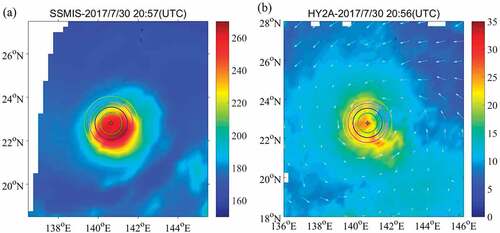
Another application of paramount importance in the context of climate studies and sustainability is hurricane monitoring. The debilitating impact of such events is challenging the successful implementation of the SDG targets, and due to climate change their power will be likely fueled even more in the upcoming years (Knutson et al., Citation2021) leading to higher socioeconomic and environmental costs. In the last 50 years, tropical cyclones have killed more than 779,000 people and caused $1.4 trillion in economic losses worldwide, according to the World Meteorological Organization (WMO). The 2020 Atlantic hurricane season had an unprecedented 30 named storms, marking the fifth year in a row with above-average hurricane activity. The benefit of using large-scale sensors such as MWRs is evident by observing the acquired images and the added-value products. In fact, such sensors can provide a whole picture of a hurricane and therefore provide a set of key information to the institutions meant to mitigate casualties and damages (see, ). In particular, multi-channel polarized microwave radiometer measurements can provide additional information of TC structure (Xiang et al., Citation2019).
Figure 2. Passive microwave measurements of Super Typhoon Noru during the mature stage of development using (a) SSMI/S, (b) HY-2A (Xiang et al., Citation2019).
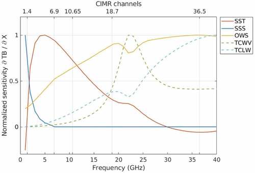
Operational services currently use microwave passive measurements as added-value products. As an example, at their scale it is possible to exploit microwave sensitivity (significant at L-band) to sea surface salinity. Physical justification can be explained by the plot in where the frequency sensitivity of passive microwave satellite observations to ocean parameters is shown (Kilic et al., Citation2021). Although in real practice the idea that at L-band the emission is insensitive to sea surface wind speed and sea surface temperature has been corrected, see, for instance, the National Aeronautics Space Administration (NASA) Aquarius mission design, it is true that the sea emission is mostly influenced by SSS at L-band (Kilic et al., Citation2021).
Figure 3. Sensitivity to SSS and other ocean parameters versus frequency (Kilic et al., Citation2021).
All the above-mentioned applications can be framed under the UN Sustainable Development Goal (SDG) 13 “Climate action”, that aims at strengthening resilience and adaptive capacity to climate-related hazards and natural disasters in all countries.
In the context of sustainability, together with the above-mentioned traditional microwave passive sensors, techniques using signals of opportunity, that is signals intended for different purposes and coming from satellites that are already operational, should stand out. As an example, Global navigation Satellite System-Reflectometry (GNSS-R), whose origin dates back to 1988 with the concept of multi-static scatterometry using GPS signals (Emery & Camps, Citation2017), uses GNSS as L-band radar sources, exploiting the fact that the latter are always available, globally, and the signal structures are well known. Such technique allows obtaining measurements of several geophysical variables such as ocean wind speed, polar ice and hydrological land parameters at a higher spatial resolution, reducing the costs an order of magnitude with respect to ad-hoc dedicated missions that necessarily result in high planning, design, and implementation costs.
Recently, the exploitation of ocean surface roughness measurements using GNSS-R has been proposed as an efficient method to detect the global distribution of ocean microplastics from space (Evans & Ruf, Citation2021). This specific application can be framed under the first target of the UN SDG 14 “Life below waters”, which states that marine pollution of all kinds must be prevented and significantly reduced.
Active sensors
Active sensors allow transmitting and receiving electromagnetic pulses and, according to the change into the structure of the scattered (received) electromagnetic field induced by the interaction with the target, one can extract geophysical information. Active sensors can be grouped into two main classes according to their area coverage: large-scale (up to thousands of kilometers) and regional or small-scale (up to few hundred kilometers). In the first class, we have real aperture radars as the scatterometer and the altimeter. The scatterometer is a high radiometric resolution sensor that measures the electromagnetic field backscattered from the ocean at variance of azimuthal direction. The special configuration of the scatterometer allows estimating the sea surface wind field, that is, wind speed and direction, according to proper inversion procedures. The scatterometer wind field estimate is at mesoscale with a spatial resolution of tens of kilometers. Scatterometer wind field products found their key role in meteorological forecasting even though they are also widely used for marine applications such as the planning of offshore wind farms. Nonetheless, in this case finer spatial resolutions are needed, and use of Synthetic Aperture Radar (SAR) measurements is due. Typically, VV polarization is used for sea surface wind estimation but for high wind regime HV polarization is better tailored (Mouche et al., Citation2017). Alternative approaches that exploit spectral information (wavelet, azimuth cut-off) or the speckle signal, a geophysical “noise” occurring in the SAR image plane due to the coherent narrow-band nature of the SAR, for wind speed estimation are under study (Corcione et al., Citation2021, Citation2018; Migliaccio et al., Citation2019). Those recent research trends suggest that, even though sea wind field estimation from satellite imagery seems to be – and to some extent it is – a mature and operational topic, there are still new insights to be explored. Although mesoscale sea wind field estimation can be associated with scatterometer measurements and, therefore, can be framed under the UN SDG 13 “Climate action”, fine-scale sea wind field estimation based on SAR measurements is logically associated with UN SDG 7 “Affordable and clean energy”. However, it must be underlined that offshore wind farms are not the only renewable and clean energy sources although it is the most relevant one when dealing with the marine environment. The interested reader can find further details in (European Commission, Citation2020a, Citation2020b; Inger et al., Citation2009).
Among the critical environments belonging to the marine ecosystem, small islands and atolls are of great interest. For instance, the Maldives archipelago consists of 26 atolls covering an area of about 300 km2 but spread over 90,000 300 km2! Considering the average sea level of 1.5 m, it is very critical in case of natural hazards such as tsunamis and flooding, especially in the perspective of the continuous sea level rise due to global warming. Hence, for such countries, early warning and alert systems are very important as well as effective tools that monitor the shoreline change induced by persistent sea level rising. In this context, microwave active sensors onboard satellite platforms represent a very useful asset. With respect to tsunami monitoring, the use of radar altimeters is coupled with dedicated buoy systems (Smith et al., Citation2005). The most advanced system is the US Tsunami Warning System. Again, the radar altimeter is a large-scale sensor so if one is interested to monitor with fine spatial resolution a smaller area the SAR is the most suitable sensor. With respect to atoll monitoring, to model both sea and land backscattering is required, that is, it is very interesting to observe very densely vegetated small islands and their shorelines (Ferrentino et al., Citation2017; Sarti et al., Citation2017). The coastline extraction by SAR measurements can be improved once polarimetric information is available (Ferrentino et al., Citation2020b, Citation2020a). An interesting study was conducted taking advantage of the peculiar Cosmo-SkyMed polarimetric SAR mode known as Ping-Pong (Migliaccio et al., Citation2014). The two polarimetric channels that are measured are the VV and HH channels and in such a mode the two acquisitions are made at a time interval that is sensitive to sea changes. Since at low-to-moderate wind regimes the VV and HH returns are highly correlated, it is possible to design a physically based filter that discriminates among different scattering scenarios (Migliaccio et al., Citation2014).
The studies related to small islands can be framed primarily under the UN SDG 14 “Life below water” but also under the UN SDG 13 “Climate action”.
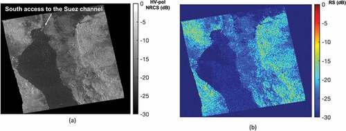
Polarimetric methodologies can be also exploited to monitor critical infrastructures at sea and oil spills (Marino et al., Citation2017; Migliaccio et al., Citation2012). A Sentinel-1 C-band SAR image relevant to the Ever Given container accident that occurred on the south side of the Suez channel in March 2021 is shown in (a). The gray-tones and dB scale SAR image collected on 25 March 2021 and referring to the cross-polarized channel is presented that clearly shows the ships, appearing as bright spots, which blocked the south access to the Suez channel. Only apparently SAR ship detection is an easy task. In fact, even considering very high-resolution SAR imaging modes, it is challenging because of the limited revisit time of a single SAR satellite but also because not all ships have a strong backscattering return due to their material or size. On a similar but different ground, one can consider the oil and gas field as well as the offshore wind farms SAR monitoring.
Figure 4. Maritime surveillance using satellite SAR imagery. (a) Cross-polarized Sentinel-1 SAR graytones image (in dB scale) acquired on 25 March 2021 after the Ever Given container accident, when the south access to the Suez channel was blocked. (b) Corresponding reflection symmetry (RS) false-colors image (in dB scale).
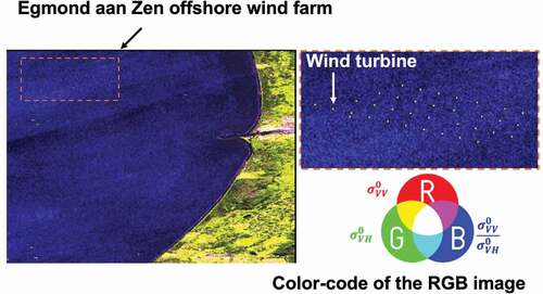
In it is shown a false-colors C-band SAR image collected over a large offshore wind farm off the coast of the Netherlands in the North Sea, namely Egmond aan Zen. The Sentinel-1 dual-polarimetric image was acquired in interferometric wide swath mode on 1 June 2019. While apparently the case shown in seems to be identical to the one shown in , this is untrue (Ferrentino et al., Citation2019). The polarimetric scattering analysis described and discussed in (Ferrentino et al., Citation2019) demonstrates that operating wind turbines have peculiar polarimetric scattering characteristics.
Figure 5. False-colors image derived from a dual-polarimetric Sentinel-1 C band SAR measurements collected over the Egmond aan Zee offshore wind farm (North Sea, The Netherlands).
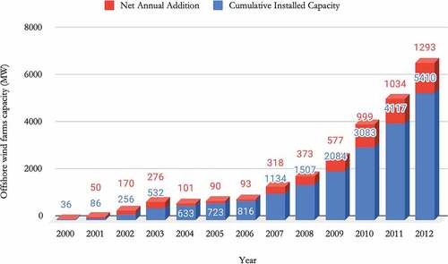
With reference to the offshore wind farms monitoring, it is also appropriate to show the plot of that demonstrates the growing and growing interest in such renewable sources of energy. A finer analysis shows that China, Germany, and UK are the countries more involved.
Figure 6. Relevant to the growing interest into offshore wind farms, adapted from (Earth Policy Institute, Citation2013).
Another interesting class of man-made structures at sea is made by aquaculture. In fact, the UN FAO statistic shows that world aquaculture has been growing from 0 to more than 100 million tons in years ranging from 1960 to 2015. In this case, China dominates the global aquaculture (1/3 of the total produced live weight). It was recently estimated that aquaculture provides 43% of all the fish consumed by humans today. This industry is not without controversies since the highly densely populated farms are the large use of chemicals and drugs to control viral, bacterial, fungal or other pathogens. In simple terms, most of the aquaculture production is of some concern for human health. Aquaculture can be observed by single-polarization and polarimetric SAR (Ballester-Berman et al., Citation2018; Profeti & Travaglia, Citation2010).
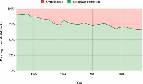
Aquaculture falls into the general problem of fishing. In fact, industrial fishing generates overexploitation. If the amount of wild fish we catch exceeds the rate at which fish can reproduce and replenish, populations will decline over time. Such populations we would call “overexploited”. In it is shown that most of the decline in sustainable fish populations occurred through the 1970s and 1980s. Over the past few decades there has been a marked slowdown of overexploitation. This is in part owed to the fact that increased demand has instead been met by aquaculture (fish farming) rather than wild catch.
Figure 7. On the status of the world’s fish stocks, adapted from (FAO, Citation2020).
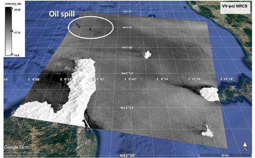
Independent observation of oil slick at sea is another relevant environmental issue. Oil at sea is very harmful to many fish species including corals. Three main classes of oil slicks can be considered depending on their size, that is, micro, macro, and huge oil slick (Migliaccio et al., Citation2015). The first class is generally associated with deliberate and illegal oil discharge by ships, the second class is usually connected to oil-tank accidents and the third one can be connected to oil platform accidents as the British Petroleum Deepwater accident in Gulf of Mexico in April 2010 (Migliaccio et al., Citation2015) and Star Petroleum accident in Gulf of Thailand in January 2022. The most tailored satellite remote sensing sensor to observe sea oil slicks is the SAR but most of the operational procedures are tailored to macro-oil slicks. As a result, most of the open available statistics undervalue the overall oil spill pollution. The interested reader can find all details of new physically based polarimetric SAR-related procedures in (Migliaccio et al., Citation2015) but hereafter a VV-polarized SAR image is shown in .
Figure 8. VV-polarized Sentinel-1 C-band SAR gray tones image, in decibel scale, overlaid on the Google Earth© layer. The image refers to a ship-based oil spill, that was about 20 km to 35 km long, occurred in the Mediterranean Sea, north of Corsica, on 8 October 2018.
The benefit of using polarimetric SAR is that the peculiar low-to-moderate sea Bragg scattering does not apply to heavy damping oil spills and, therefore, the multi-steps conventional single-polarization procedures that must be assisted by human personnel can be fully automated (Meng et al., Citation2021).
All referred monitoring activities fall into the UN SDGs and especially the SDG 14 “Life below water”.
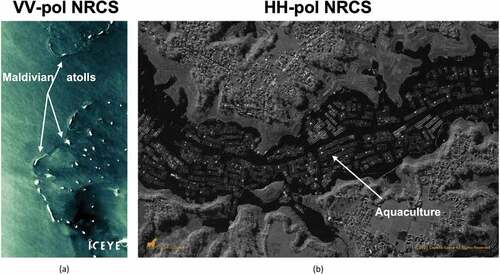
It is also worth noting that, in recent years, the management of marine-related hazards that call for demanding time, that is, real-time and near real-time, and spatial, that is, resolution down to 3 m, constraints, can get benefits by SAR observations collected from small-satellite constellations (Kramer & Cracknell, Citation2008). Small-satellites constellations, whose launch was boosted by the advancements of engineering miniaturization technologies, consist of dozens of satellites equipped with cheap and small-weight, that is, down to a few kilograms, SAR sensors (usually at X-band) that allow providing extremely dense revisit times, down to 24 hours (Peral et al., Citation2018). Among them, one can mention the operating Finnish ICEYE and the US Capella space missions that launched their first micro-SAR satellites in 2018. When fully operational, they will consist of 18 and 36 SAR satellites, respectively, providing imagery with a revisit time down to 6 hours and a very-high spatial resolution finer than 1 m depending on the latitude and the imaging mode. Accordingly, those micro-SAR satellites represent a key asset that offer persistent fine-resolution daily observations which are crucial to address quick responses to natural hazards such as flood monitoring and storms and to improve maritime surveillance as tracking fast-moving ships.
As a showcase, shows the potential of ICEYE (a) and Capella (b) X-band SAR sensors to support operational monitoring of the marine environment (Capella Space, Citation2022; ICEYE, Citation2022). They refer to the routine observation of small atolls in the Maldivian archipelago and water supply and aquaculture, including fishing farming structures, respectively.
Figure 9. Micro-SAR satellites. (a) VV-polarized ICEYE StripMap image collected on 25 December 2019 over the northernmost atolls of Maldives, Indian ocean (courtesy of ICEYE under creative common license). (b) HH-polarized Capella spotlight image collected on 13 January 2021 over the Saguling dam reservoir in West Java, Indonesia (courtesy of Capella Space).
Microwave satellite remote sensing for a sustainable sea
In this Section, we provide a critical general framework in which some key microwave remote sensing applications can effectively provide support to ocean sustainability. While the approach is general, the rationale is to emphasize – using meaningful showcases – how a quality standard can be promoted by microwave remote sensing added-value products.
Before proceeding further, it is important to underline a semantic problem that occurs even in scientific literature (Martínez-Vázquez et al., Citation2021). In fact, in such a study it is examined as apparently similar terms are wrongly interchanged. For instance, ocean economy or blue growth are not at all identical to blue economy.
Another key critical factor is related to the actual relationship between the sustainability philosophy and the global scale UN SDGs (Lee et al., Citation2020; Martínez-Vázquez et al., Citation2021). In (Lee et al., Citation2020) it is pointed out that the identification of scope and boundaries of the blue economy in line with the UN’s SDGs is unfortunately vague. Accordingly, this impacts directly on stakeholders’ behavior. Furthermore, it is underlined in (Martínez-Vázquez et al., Citation2021) that linking the blue economy philosophy to the UN SDGs targets is challenging also because the objectives are interconnected. Apart from such a theoretical criticism, on the practical side the interpretation of the SDGs is rather heterogeneous, especially when comparing less developed countries with developed ones (Martínez-Vázquez et al., Citation2021). On the practical side, countries are making decisions according to their own needs (Wenhai et al., Citation2019), still pushed by a short-term vision which is ruled by the present economic, political, social, cultural, and environmental context (Martínez-Vázquez et al., Citation2021). The real picture is complex and, in fact, there are less developed countries in which the awareness of a wild economic growth is a peril for marine environment and human wellbeing (Bennett et al., Citation2019; UNCTAD, Citation2014). In Small Island Developing States (SIDS) a great concern is paid to risks associated with rising ambient temperatures and sea levels. On the economic viewpoint, although the level of dependence on oceans can vary among SIDS, it is always remarkable.
National heterogeneity is not the only factor to be considered. The other important factor is related to the different economic sectors relying on marine resources. With these respects, the fundamental study reported in (Virdin et al., Citation2021) must be considered. It is shown that the 10 largest companies in 8 core ocean economy industries generate, on average, 45% of each industry’s total revenues. In summary, the 100 largest corporations, also named by the Authors as “Ocean 100”, account for 60% of total revenues. Of course, such a concentration level is at the same time a risk and an opportunity. Among them, the biggest industry in the Ocean 100 is offshore oil and gas, followed by shipping, shipbuilding and repair, maritime equipment and construction, seafood production (4%), cruise tourism (3%), and port activities (2%; Virdin et al., Citation2021).
The requested high technical skills and capitals to operate in oceans create a natural barrier to small companies and this is a common trait of all “Ocean 100” (Virdin et al., Citation2021). However, the “Ocean 100” companies are highly heterogeneous in many respects including the sensitivity to the blue economy philosophy. Although voluntary company efforts cannot guarantee the success of the blue economy, it must be underlined that in some specific sectors the sensitivity is higher and the economic concentration in few companies help to push in the correct direction. In (Virdin et al., Citation2021) it is suggested that although some “green clubs” may naturally arise, that is, groups of companies that voluntarily commit to undertake sustainability measures, they are not able to lead to sustainability without public regulatory policies. Along with such policies it is also underlined that creating incentives for rapid innovation in business strategy is an important task to be considered. Financing a sustainable ocean economy is the topic of (Sumaila et al., Citation2021) among others.
In summary, a three-legs action is meant to be successful: 1) a social and cultural changes that consider not appropriate to act and support companies that spoil the future of the oceans, that is, promoting voluntary “green clubs”; 2) nationally standardized and international regulatory policies as well as 3) financial support to create strategic changes into the business strategy and practice.
With respect to point 2), to enforce nationally standardized and international regulatory policies satellite remote sensing technology is considered a unique and valuable source of information. In fact, satellite remote sensing is a non-cooperative measurement technique that is open access and available to agencies in developed and less developed countries. All this matter is meant to facilitate the so-called alignment of the blue economy with the UN SDGs (Lee et al., Citation2020). Although ocean remote sensing is meant as the primary source of information, some key open questions remain to be solved (McCarthy et al., Citation2017; Zhang et al., Citation2021). In particular, in (Zhang et al., Citation2021) it is claimed that three main issues must be considered in order to strengthen the role of remote sensing for SDGs monitoring: 1) data availability, sharing and openness; 2) added-value marine data standard quality, that is, the variability in quality of geophysically interpreted remote sensing data and 3) multi-source data interoperability.
Although the blue economy and the use of microwave remote sensing to support the blue economy is a multi facets problem, in the Authors’ opinion, it is important to provide to remote sensing scientists the general framework and the challenges that must be tackled. In particular, it is important that, on the science side, all efforts are made to match the requested needs. In view of this, it is here depicted how in some key showcases microwave remote sensing can provide a unique support to ocean sustainability.
Two sector cases, oil and gas and offshore wind farms, and an intersectoral case, plastic pollution, are considered.
As already previously mentioned, oil and gas companies are connected to the greatest revenues in the marine economy (Virdin et al., Citation2021). Oil and gas exploration and drilling are challenging high technologies skills that are concentrated in few enterprises. Such activities are environmentally risky as well as oil transportation. Coordinated actions to monitor oil fields and oil transportation are essential to enforce environmental policies. The most effective and advanced monitoring systems benefit from wide area monitoring by microwave remote sensing, typically SAR, mounted on board of appropriately designed surveillance airplanes along with satellite SAR measurements. The implementation of such well-designed monitoring systems along with clear and tough environmental norms has reduced the occurrence of illegal oil discharge. In simple words, the satellite and airborne SAR surveillance is a deterrent that is effective, see for example, the Belgian case (Schallier & Van Roy, Citation2016). In order to enhance the SAR monitoring service of oil spills three main lines of development can be envisaged in the near future: a) use of small satellites to reduce costs and enhance revisit time (Kramer & Cracknell, Citation2008); b) employ new SAR imaging modes that allow, for instance, to cover large area with polarimetric measurements without losing spatial resolution (Migliaccio et al., Citation2015) and c) use polarimetric SAR measurements to improve the quality of the added-value products (Migliaccio & Nunziata, Citation2014).
It must be noted that such near future trends are not at all unrealistic since the ICEYE constellation, although not designed with this application in mind, provides single-polarization SAR coverage ensured by a large set of small satellites (Peral et al., Citation2018). Furthermore, the second point is under development at the German Aerospace Center (DLR) and is known as staggered SAR and the benefit of polarimetric SAR measurements in oil spill monitoring is well assessed in terms of frequency diversity (L-, C- and X-band), processing time and spatial resolution (Migliaccio et al., Citation2015; Villano et al., Citation2021).
Moving to the renewable energy sector, the most relevant marine source of energy is the wind (European Commission, Citation2020a, Citation2020b). Offshore wind farms make a substantial contribution to the electricity supply. In such a sector, leading countries are China and Europe as a whole, with northern European countries at lead. In this context, microwave remote sensing plays a role in looking for the best location of the offshore wind farms since, by exploiting the peculiar scatterometer measurements, it is possible to estimate the wind field at mesoscale (Emery & Camps, Citation2017). Thanks to the heritage of scatterometer missions, it is also possible to have a first glance of the winds in a given area. In addition, to estimate sea surface wind field at finer spatial scale it is possible to exploit SAR measurements, typically co-polarized VV-pol measurements, to retrieve the wind speed once that a first guess about the wind direction is provided. When high wind regime applies, that is, wind speed larger than about 20 m/s, co-polarized SAR measurements saturate and use of cross-pol SAR measurements must be considered (Mouche et al., Citation2017). When the offshore wind farm is operational, it is advisable to monitor the status of the plant by exploiting co-pol and cross-pol SAR measurements as well as microDoppler effect due to the turbine blade motion (Mouche et al., Citation2017; Nepal et al., Citation2015).
With reference to the third showcase, plastic is the most common type of debris floating in the world’s oceans. Plastic originates with a variety of coastal and ocean-based sources across industries, enters the water in many ways, and negatively impacts the oceans. Most of the plastic debris comes from anthropogenic coastal activities but also by fishing ones (UNEP, Citation2019). In (UNEP, Citation2019), it is clearly underlined that it is a challenging problem and several and diverse gaps must be filled to mitigate or solve the problem at the origin. In (Virdin et al., Citation2021), it is explicitly pointed out that companies should not only exploit public incentives to move to a new sustainable business model but also contribute to costs of cleanup of marine plastic debris. This issue is analyzed in more detail in (Landon-Lane, Citation2018), where it is claimed that only harnessing corporate social responsibility such a wicked problem can be realistically tackled. Of course, cleanup needs to know where plastic debris is.
Within such a challenging framework, it is important to underline how microwave satellite remote sensing can contribute to monitor plastics at sea. A very recent and promising approach is the use of GNSS-R measurements. The NASA Cyclone Global Navigation Satellite System (CYGNSS) is a network of eight microsatellites that was launched in 2016 to help scientists predict hurricanes by analyzing tropical wind speeds. Physically speaking, the measurements are related to the sea roughness induced by the wind but sea roughness anomalies can be interpreted as potential plastic presence (Evans & Ruf, Citation2021). Such large-scale observations are able to provide reliable plastic maps at global level (Evans & Ruf, Citation2021).
Conclusions
Oceans and seas sustainability call for an integrated approach that sum up a paradigmatic change in moral values, laws, and technologies. In simple terms, it is only possible if a holistic long-term vision is meant. In this paper, we have depicted on one side the complexity of a sustainable development and on the other side the opportunities given by a growing and growing public consciousness. The role of microwave remote sensing has been outlined by a set of examples but also in connections of two blue economy sectoral cases: the oil and gas sector and the renewable energy sector. Further, a third intersectoral case has been illustrated related to the plastic debris pollution.
Ultimate goal of the paper is to provide to the microwave remote sensing community a reference framework to align their scientific efforts toward sea sustainability.
Acknowledgments
The Authors would thank ESA to provide Sentinel-1 SAR data free of charge through the Copernicus scientific data hub.
Disclosure statement
No potential conflict of interest was reported by the author(s).
References
- Alparone, M., Nunziata, F., Estatico, C., Lenti, F., & Migliaccio, M. (2019). An adaptive $ L^{p} $-Penalization method to enhance the spatial resolution of microwave radiometer measurements. IEEE Transactions on Geoscience and Remote Sensing, 57(9), 6782–6791. https://doi.org/10.1109/TGRS.2019.2908560
- Alparone, M., Nunziata, F., Estatico, C., & Migliaccio, M. (2020). A multichannel data fusion method to enhance the spatial resolution of microwave radiometer measurements. IEEE Transactions on Geoscience and Remote Sensing, 59(3), 2213–2221. https://doi.org/10.1109/TGRS.2020.3005204
- Ballester-Berman, J. D., Sanchez-Jerez, P., & Marino, A. (2018, June). Detection of aquaculture structures using Sentinel-1 data. In EUSAR 2018; 12th European Conference on Synthetic Aperture Radar (pp. 1–4). VDE.
- Bennett, N. J., Cisneros-Montemayor, A. M., Blythe, J., Silver, J. J., Singh, G., Andrews, N., Calò, A., Christie, P., Di Franco, A., Finkbeiner, E. M., Gelcich, S., Guidetti, P., Harper, S., Hotte, N., Kittinger, J. N., Le Billon, P., Lister, J., López de la Lama, R., McKinley, E., … Sumaila, U. R. (2019). Towards a sustainable and equitable blue economy. Nature Sustainability, 2(11), 991–993. https://doi.org/10.1038/s41893-019-0404-1
- Capella Space (2022): gallery archive, available at https://www.capellaspace.com/gallery/
- Corcione, V., Buono, A., Nunziata, F., & Migliaccio, M. (2021). A sensitivity analysis on the spectral signatures of low-backscattering sea areas in Sentinel-1 SAR images. Remote Sensing, 13(6), 1183. https://doi.org/10.3390/rs13061183
- Corcione, V., Grieco, G., Portabella, M., Nunziata, F., & Migliaccio, M. (2018). A novel azimuth cutoff implementation to retrieve sea surface wind speed from SAR imagery. IEEE Transactions on Geoscience and Remote Sensing, 57(6), 3331–3340. https://doi.org/10.1109/TGRS.2018.2883364
- Earth Policy Institute (2013). 2013 to be a record year for offshore wind, available at: http://www.earth-policy.org/plan_b_updates/2013/update117
- Emery, B., & Camps, A. (2017). Introduction to satellite remote sensing: Atmosphere, Ocean, Land and Cryosphere Applications. Elsevier Science.
- ESA. (2020) . Copernicus imaging microwave radiometer (CIMR) mission requirements document v4.0, ESA-EOPSM-CIMR-MRD-3236. Earth and Mission Science Division Reference.
- European Commission (2020a). Marine renewable energy. https://ec.europa.eu/oceans-and-fisheries/ocean/blue-economy/marine-renewable-energy_en
- European Commission (2020b). Communication from the Commission to the European Parliament, the Council, the European Economic and Social Committee and the Committee of the Regions - An EU Strategy to harness the potential of offshore renewable energy for a climate neutral future. https://eur-lex.europa.eu/legal-content/EN/TXT/?uri=COM%3A2020%3A741%3AFIN
- European Parliament (2017). Resolution of 16 March 2017 on an integrated European Union policy for the Arctic, 2016/2228(INI). https://www.europarl.europa.eu/doceo/document/TA-8-2017-0093_EN.html?redirect
- Evans, M. C., & Ruf, C. S. (2021). Toward the detection and imaging of ocean microplastics with a spaceborne radar. IEEE Transactions on Geoscience and Remote Sensing, 60, 1–9. https://doi.org/10.1109/TGRS.2021.3081691
- FAO (2020). Share of fish stocks within biologically sustainable levels, available at: https://www.fao.org/sustainable-development-goals/indicators/1441/en/
- Ferrentino, E., Buono, A., Nunziata, F., Marino, A., & Migliaccio, M. (2020b). On the use of multipolarization satellite SAR data for coastline extraction in harsh coastal environments: The case of solway firth. IEEE Journal of Selected Topics in Applied Earth Observations and Remote Sensing, 14, 249–257. https://doi.org/10.1109/JSTARS.2020.3036458
- Ferrentino, E., Nunziata, F., Buono, A., Urciuoli, A., & Migliaccio, M. (2020a). Multipolarization time series of sentinel-1 SAR imagery to analyze variations of reservoirs’ water body. IEEE Journal of Selected Topics in Applied Earth Observations and Remote Sensing, 13, 840–846. doi:10.1109/JSTARS.2019.2961563
- Ferrentino, E., Nunziata, F., Marino, A., Migliaccio, M., & Li, X. (2019). Detection of wind turbines in intertidal areas using SAR polarimetry. IEEE Geoscience and Remote Sensing Letters, 16(10), 1516–1520. https://doi.org/10.1109/LGRS.2019.2905714
- Ferrentino, E., Nunziata, F., & Migliaccio, M. (2017). Full-polarimetric SAR measurements for coastline extraction and coastal area classification. International Journal of Remote Sensing, 38(23), 7405–7421. https://doi.org/10.1080/01431161.2017.1376128
- Hardin, G. (1968). The tragedy of commons. Science, 162(12), 1243–1248. https://doi.org/10.1126/science.162.3859.1243
- ICEYE (2022). Iceye public archive. https://www.iceye.com/lp/iceye-18000-public-archive
- Inger, R., Attrill, M. J., Bearhop, S., Broderick, A. C., James Grecian, W., Hodgson, D. J., Mills, C., Sheehan, E., Votier, S. C., Witt, M. J., & Godley, B. J. (2009). Marine renewable energy: Potential benefits to biodiversity? An urgent call for research. Journal of Applied Ecology, 46(6), 1145–1153. https://doi.org/10.1111/j.1365-2664.2009.01697.x
- Kilic, L., Prigent, C., Jimenez, C., & Donlon, C. (2021). A sensitivity analysis from 1 to 40 GHz for observing the arctic ocean with the Copernicus imaging microwave radiometer. Ocean Science, 17(2), 455–461. https://doi.org/10.5194/os-17-455-2021
- Knutson, T. R., Chung, M. V., Vecchi, G., Sun, J., Hsieh, T. L., & Smith, A. J. (2021). Climate change is probably increasing the intensity of tropical cyclones. Critical issues in climate change science. ScienceBrief Review. https://doi.org/10.5281/zenodo.4570334
- Kramer, H. J., & Cracknell, A. P. (2008). An overview of small satellites in remote sensing. International Journal of Remote Sensing, 29(15), 4285–4337. https://doi.org/10.1080/01431160801914952
- Landon-Lane, M. (2018). Corporate social responsibility in marine plastic debris governance. Marine Pollution Bulletin, 127, 310–319. https://doi.org/10.1016/j.marpolbul.2017.11.054
- Lavergne, T., Pinol Sole, M., & Donlon, C. (2019). Daily coverage of CIMR (Arctic, Antarctic, and global views. figshare. https://doi.org/10.6084/m9.figshare.7749284.v1
- Lee, K.-H., Noh, J., & Khim, J. S. (2020). The blue economy and the United Nations’ sustainable development goals: Challenges and opportunities. Environment International, 137, 105528. https://doi.org/10.1016/j.envint.2020.105528
- Lloyd, W. F. (1883). Two lectures on the checks to population. Oxford University Press.
- Long, D. G., Brodzik, M. J., & Hardman, M. A. (2019). Enhanced-resolution SMAP brightness temperature image products. IEEE Transactions on Geoscience and Remote Sensing, 57(7), 4151–4163. https://doi.org/10.1109/TGRS.2018.2889427
- Marino, A., Velotto, D., & Nunziata, F. (2017). Offshore metallic platforms observation using dual-polarimetric TS-X/TD-X satellite imagery: A case study in the Gulf of Mexico. IEEE Journal of Selected Topics in Applied Earth Observations and Remote Sensing, 10(10), 4376–4386. https://doi.org/10.1109/JSTARS.2017.2718584
- Martínez-Vázquez, R. M., Milán-García, J., & de Pablo Valenciano, J. (2021). Challenges of the blue economy: Evidence and research trends. Environmental Sciences Europe, 33(61):1-17. https://doi.org/10.1186/s12302-021-00502-1
- McCarthy, M. J., Colna, K. E., El-Mezayen, M. M., Laureano-Rosario, A. E., Méndez-Lázaro, P., Otis, D. B., Toro-Farmer, G., Vega-Rodriguez, M., & Muller-Karger, F. E. (2017). Satellite remote sensing for coastal management: A review of successful applications. Environmental Management, 60(2), 323–339. https://doi.org/10.1007/s00267-017-0880-x
- Mecklenburg, S., Albergel, C., Cipollini, P., Sabia, R., Seifert, F. M., & Trofaier, A. M. (2021) ESA’S climate change initiative: How SMOS contributes. IEEE International Geoscience and Remote Sensing Symposium IGARSS, pp. 1114–1115.
- Meng, T., Yang, X., Chen, K.-S., Nunziata, F., Xie, D., & Buono, A. (2021). Radar backscattering over sea surface oil emulsions: Simulation and observation. IEEE Transactions on Geoscience and Remote Sensing. 60.
- Migliaccio, M., Huang, L., & Buono, A. (2019). SAR speckle dependence on ocean surface wind field. IEEE Transactions on Geoscience and Remote Sensing, 57(8), 5447–5455. https://doi.org/10.1109/TGRS.2019.2899491
- Migliaccio, M., Mascolo, L., Nunziata, F., Sarti, M., & Mazzarella, G. (2014). COSMO-SkyMed HH/VV PingPong mode SAR data to discriminate among sea, urban, and vegetated areas. IEEE Journal of Selected Topics in Applied Earth Observations and Remote Sensing, 7(7), 2880–2894. https://doi.org/10.1109/JSTARS.2014.2339631
- Migliaccio, M., & Nunziata, F. (2014). On the exploitation of polarimetric SAR data to map damping properties of the Deepwater Horizon oil spill. International Journal of Remote Sensing, 35(10), 3499–3519. https://doi.org/10.1080/01431161.2014.905730
- Migliaccio, M., Nunziata, F., & Buono, A. (2015). SAR polarimetry for sea oil slick observation. International Journal of Remote Sensing, 36(12), 3243–3273. https://doi.org/10.1080/01431161.2015.1057301
- Migliaccio, M., Nunziata, F., Montuori, A., & Paes, R. L. (2012). Single-look complex COSMO-SkyMed SAR data to observe metallic targets at sea. IEEE Journal of Selected Topics in Applied Earth Observations and Remote Sensing, 5(3), 893–901. https://doi.org/10.1109/JSTARS.2012.2184271
- Mouche, A. A., Chapron, B., Zhang, B., & Husson, R. (2017). Combined co- and cross-polarized SAR MEASUREMENTS UNDER EXTREME WIND CONDITIONS. IEEE Transactions on Geoscience and Remote Sensing, 55(12), 6746–6755. https://doi.org/10.1109/TGRS.2017.2732508
- Nepal, R., Cai, J., & Zhang, Y. (2015). Micro-Doppler radar signature identification within wind turbine clutter based on short-CPI airborne radar observations. IET Radar, Sonar & Navigation, 9(9), 1268–1275. https://doi.org/10.1049/iet-rsn.2015.0111
- Nunziata, F., Alparone, M., Camps, A., Park, H., Zurita, A. M., Estatico, C., & Migliaccio, M. (2022). An enhanced resolution brightness temperature product for future conical scanning microwave radiometers. IEEE Transactions on Geoscience and Remote Sensing, 60, 1–12. https://doi.org/10.1109/TGRS.2021.3109376
- Nunziata, F., Buono, A., Moctezuma, M. F., Parmiggiani, F., & Migliaccio, M. (2017). Observations of Terra Nova Bay polynya by Radarsat-2: Comparison of dual- with single-polarization segmentation performances. In RTSI 2017-IEEE 3rd International Forum on Research and Technologies for Society and Industry, Conference Proceedings.
- Nunziata, F., Li, X., Marino, A., Shao, W., Portabella, M., Yang, X., & Buono, A. (2021). Microwave satellite measurements for coastal area and extreme weather monitoring. Remote Sensing, 13(16), 3126. https://doi.org/10.3390/rs13163126
- O’Connor, B., Moul, K., Pollini, B., de Lamo, X., & Simonson, W. (2020), Earth observation for SDG – compendium of earth observation contributions to the SDG targets and indicators, ESA contract No. 4000123494/18/I-NB.
- Peral, E., Im, E., Wye, L., Lee, S., Tanelli, S., Rahmat-Samii, Y., Horst, S., Hoffman, J., Yun, S.-H., Imken, T., & Hawkins, D. (2018). Radar technologies for earth remote sensing from cubesat platforms. Proceedings of the IEEE, 106(3), 404–418. https://doi.org/10.1109/JPROC.2018.2793179
- Profeti, G., & Travaglia, C. (2010). Monitoring aquaculture structures by means of SAR imagery. Geospatial World.
- Rahmstorf, S. (2006). Thermohaline ocean circulation. Encyclopedia of Quaternary Sciences, 5.
- Rayner, R., Jolly, C., & Gouldman, C. (2019). Ocean observing and the blue economy. Frontiers of Marine Science, 6(330), 1–6. https://doi.org/10.3389/fmars.2019.00330
- Santi, E. (2010). An application of the SFIM technique to enhance the spatial resolution of spaceborne microwave radiometers. International Journal of Remote Sensing, 31(9), 2419–2428. https://doi.org/10.1080/01431160903005725
- Sarti, M., Migliaccio, M., Nunziata, F., Mascolo, L., & Brugnoli, E. (2017). On the sensitivity of polarimetric SAR measurements to vegetation cover: The Coiba National Park, Panama. International Journal of Remote Sensing, 38(23), 6755–6768. https://doi.org/10.1080/01431161.2017.1363439
- Schallier, R., & Van Roy, W. (2016). Oil pollution in and around the waters of Belgium. In A. Carpenter (Ed.), Oil pollution in the north sea (pp. 93–116). Springer.
- Smith, A. (1776). An inquiry into the nature and causes of the wealth of nations: Volume one (pp. 1776). printed for W. Strahan; and T. Cadell.
- Smith, Jr, W. O., & Barber, D. (Eds.). (2007). Polynyas: Windows to the world, Chapter 13: Polynyas and climate change: A view to the future. Elsevier.
- Smith, W. H., Scharroo, R., Titov, V. V., Arcas, D., & Arbic, B. K. (2005). Satellite altimeters measure tsunami. Oceanography, 18(2), 11–13. https://doi.org/10.5670/oceanog.2005.62
- Sumaila, U. R., Walsh, M., Hoareau, K., Cox, A., Teh, L., Abdallah, P., Akpalu, W., Anna, Z., Benzaken, D., Crona, B., Fitzgerald, T., Heaps, L., Issifu, I., Karousakis, K., Lange, G. M., Leland, A., Miller, D., Sack, K., Shahnaz, D., and Zhang, J. (2021). Financing a sustainable ocean economy. Nature Communications, 12(1): 1-11. https://doi.org/10.1038/s41467-021-23168-y
- UNCTAD. (2014). The oceans economy: opportunities and challenges for small island developing states.
- UNEP. (2019). Addressing marine plastics: A systemic approach - Recommendations for action.
- Van Dover, C. L., Ardron, J. A., Escobar, E., Gianni, M., Gjerde, K. M., Jaeckel, A., Jones, D. O. B., Levin, L. A., Niner, H. J., Pendleton, L., Smith, C. R., Thiele, T., Turner, P. J., Watling, L., & Weaver, P. P. E. (2017). Biodiversity loss from deep-sea mining. Nature Geoscience, 10(7), 464–465. https://doi.org/10.1038/ngeo2983
- Vanin, F., Laberinti, P., Donlon, C., Fiorelli, B., Barat, I., Sole, M. P., Galeazzi, C. (2020, September). Copernicus imaging microwave radiometer (CIMR): System aspects and technological challenges. In IGARSS 2020-2020 IEEE International Geoscience and Remote Sensing Symposium (pp. 6535–6538). IEEE.
- Villano, M., Nogueira Peixoto, M., Ustalli, N., Krieger, G., & Moreira, A. (2021, July). Staggered SAR: Recent advances and design trade-offs. In EUSAR 2021; 13th European Conference on Synthetic Aperture Radar (pp. 1–6). VDE.
- Virdin, J., Vegh, T., Jouffray, J.-B., Blasiak, R., Mason, S., Österblom, H., Vermeer, D., Wachtmeister, H., & Werner, N. (2021). The Ocean 100: Transnational corporations in the ocean economy. Science Advances, 7(3): 1-10. https://doi.org/10.1126/sciadv.abc8041
- Wenhai, L., Cusack, C., Baker, M., Tao, W., Mingbao, C., Paige, K., Xiaofan, Z., Levin, L., Escobar, E., Amon, D., Yue, Y., Reitz, A., Neves, A. A. S., O’Rourke, E., Mannarini, G., Pearlman, J., Tinker, J., Horsburgh, K. J., Lehodey, P., and Yufeng, Y. (2019). Successful blue economy examples with an emphasis on international perspectives. Frontiers in Marine Science, 6(261):1-14. https://doi.org/10.3389/fmars.2019.00261
- World Bank, & United Nations Department of Economic and Social Affairs. (2017). The potential of the blue economy: Increasing long-term benefits of the sustainable use of marine resources for small island developing states and coastal least developed countries.
- Xiang, K., Yang, X., Zhang, M., Li, Z., & Kong, F. (2019). Objective estimation of tropical cyclone intensity from active and passive microwave remote sensing observations in the Northwestern Pacific Ocean. Remote Sensing, 11(6), 627. https://doi.org/10.3390/rs11060627
- Zhang, B., Li, F., Zheng, G., Wang, Y., Tan, Z., & Li, X. (2021). Developing big ocean system in support of sustainable development goals: Challenges and countermeasures. Big Earth Data, 5(4), 557–575. https://doi.org/10.1080/20964471.2021.1965371