
Abstract
This paper presents a multi-criteria conceptual framework for decision-making processes during Territorial and Administrative Reform (TAR) relying on sustainable development principles. In general, TAR processes highly consider socio-cultural and economic factors, but they lack responsiveness to environmental dynamics of the context. While this practice achieves a fair allocation of the new administrative units’ centers, the border defining criteria are indistinct. Thus, we turn a spotlight on the environmental factors as fundamental criteria in TAR decision-making processes, especially the boundary definition stage. Topography, watershed, land cover, and natural conservation areas are among the proposed environmental measures. The research makes a real case of land cover data utilization as environmentally sensitive decision-making mediator. First, the CORINE Land Cover (CLC) data of 2012 serves as an evaluation criteria of the recent TAR (2014) in Albanian territory, based on the landscape fragmentation caused by the new spatial division. Second, the CLC data generates an alternative municipal boundary of the Albanian capital. The results show that a TAR process not taking into account the environmental criteria leads to functionally disconnected territories which in the long run may lead to physically fragmented natural landscapes. Furthermore, the new alignment for municipal borders of Tirana shows a successful result in minimizing natural landscape fragmentation caused by local administrative boundaries. The proposed multi-criteria conceptual framework and the application via CLC utilization presents a methodical approach which may assist decision-making processes of TAR in other developing countries, conform sustainable territorial management principles.
Public Interest Statement
TAR is a crucial decision-making process, having direct impact on social, economic, and environmental aspects in both national and local levels. A tangible outcome of TAR is the territorial subdivision of the national lands into local administrative units. In general, during decision-making process of TAR, the social and economic factors are being highly considered, but the environmental ones are neglected. This practice leads to conflictual relationship between the administrative border line and natural landscapes. The split administrative competences, over the same natural surface separated by the border line, may cause landscape fragmentation, which leads to natural lands degradation. This study, first, analyzes the recent TAR in Albania quantifying landscape fragmentation caused by the current territorial subdivision. Furthermore, it presents a method to use land cover data as a guide to define new local administrative borders to minimize natural landscapes’ fragmentation.
1. Introduction
The conflict between the political borders and cross-boundary ecoregions is a well-known issue in conservation studies (Kark et al., Citation2015). The main contradiction relies on the transboundary character of ecological services (Hoffman, Varady, Flessa, & Balvanera, Citation2009), while specific governmental bodies perform the conservation planning practice within the boundary jurisdiction. This practice significantly brings uncoordinated interventions (Jantke & Schneider, Citation2010) and sometimes even interfering/overlapping/duplicating each other (Gordon, Bastin, Langford, Lechner, & Bekessy, Citation2013). Certainly, there is an emphasis on the collaboration among a variety of actors as well as across spatial borders (political, regional, municipal, and others) (Mace et al., Citation2000). Moreover, the natural conservation issue is of a multi-range character including a variety of shareholders acting at different spatial scales (Guerrero, Mcallister, & Wilson, Citation2014) such as, global, regional, or local. In the global scale, the international collaboration in natural conservation agendas might be the only solution toward cross-border conservation goals. This is due to the fact that the national borders apparently are a product of the most extreme conflicts (wars) among the humankind (Harvey & Most, Citation1976), and their readjustment is the last considerable alternative on the table.
Differently, in the local scale, the administrative boundaries within the national borders and the subdivision of the territory into local administrative units are a vibrant topic continuously consuming a serious discussion. One of the most tangible platforms of the debate is the Territorial and Administrative Reform (TAR), which is still scholarly under-estimated (Kuhlmann & Wollmann, Citation2011). The reforms of the local administration and the territorial reorganization were first applied during the ‘60s and the ‘70s (Norton, Citation1994) for the western European countries, and after the ‘90s for the post-socialist countries (Wollmann, Citation2010). The TAR process follows certain criteria to perform the territorial subdivision. Generally, the socio-cultural and economic factors are seriously considered during the decision-making processes of TAR. However, the case is not the same with the environmental criteria which are substantially ignored, despite being advocated to be the third pillar of sustainable development (Giovannoni & Fabietti, Citation2013; Hens, Citation1996).
This practice results in justified decisions on the amount and centers’ location (urbanized areas) of the new administrative units. But, it remains insufficient in reasonably defining the administrative boundary line, especially while crossing through natural lands. As a consequence, the borders defined, based only on the socio-cultural and economic factors, result in functionally divided natural landscapes, which later might lead to permanent physical landscape fragmentation. In this study, the landscape fragmentation stands for the phenomenon not caused by physical barriers; it is a breakup of the interest and the consumption methods toward a specific common pool resource (CPR) (Ostrom, Citation2010) split among different, local administrative units (Swianiewicz, Citation2010). In the long-run, the split management and administration of a specific natural landscape surface may lead to physical landscape fragmentation.
In this context, the study focuses on the local scale, first, by conceptually discussing the multi-criteria character of the decisions within TAR processes. Furthermore, we propose a conceptual framework based on sustainable landscapes principles (Buttimer, Citation2001). Even though, it still relies on three fundamental pillars (social, economic, and environmental) of sustainable development, sustainable landscapes notion brings a decoupling between “sustainability” and “development” by implying that the former already bears the latter within itself (Blaschke, Citation2006). In consequence, we structured the criteria of the proposed framework into three main groups: the socio-cultural, the economic, and the environmental criterion. Each category consists of several sub-criteria being organized by their role and scope within the TAR process.
Beyond the conceptual multi-criteria approach, the paper presents a demonstrative application of the framework by utilizing land cover data as an environmental sub-criteria in the decision-making process of TAR, especially during local administrative boundary definition phase. The experiment relies on CORINE Land Cover (CLC) data of 2012 applied upon the recent TAR of Albanian territory (2014). CLC data are currently labeled as a well-established and reliable information source in support of environmental policy-making (Steenmans, Citation2016). The spatial relationship between CLC data and the current, local administrative borders provides pieces of evidence of landscape fragmentation caused by the reform. Furthermore, CLC data are empirically put forward as local administrative boundary definition mean as shown here for the case of Tirana. The experiential stages of this study are performed utilizing ArcGIS 10.2.2 software.
2. Case study: territorial and administrative reform in Albania
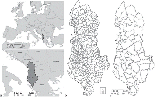
In 2014, Albania ratified the administrative and territorial reform as a demand by the European Union within the decentralization processes of local administration (Reçi & Ymeri, Citation2016). The new divisions, referred to as development zones, are responsible for the funds’ management on economic and social development of candidate countries (Ghinea & Moraru, Citation2006). The territory is re-organized from 374 (65 municipalities and 309 communes within 36 localities joining into 12 prefectures) (Figure )) administrative units to 61 municipal districts (Ndreu, Citation2016) (Figure )). The local administration reform of decentralization reduced distinctly the institutional ties and dependency between central and local governments. Moreover, the new reform annihilated a core administrative unit of the pre-reform version such as “rreth,” reported as administratively ineffective (Saltmarshe, Citation2001). According to the new local administrative map of Albania, provided via the geoportal by the Albanian State Authority of Geospatial Information, the new layout decreased the local administrative borders cumulative length by more than 50%, specifically from 7766 km to 3583 km (ASIG, Citation2015).
Figure 1. Location of Albania within Europe (a) and the Albanian local administrative maps; pre-TAR (b), post-TAR (c).
The recent Albanian TAR is criticized for being highly driven by electoral interest (Krasniqi, Citation2014), which is a well-known concern having earlier been addressed by different scholars even in western European regions such as Flanders (De Peuter, Pattyn, & Wayenberg, Citation2011). This is due to the fact that the reform process may lead to alterations of political posts, job security, and prestige (Swianiewicz, Citation2010). Beyond the political discourse, the official technical report of TAR in Albania highlights to have considered a variety of social and economic criteria during the decision-making process. For example, the concept of Functional Zones defines a territorial area characterized by dense and substantial interaction between citizens and institutions with economic, social development, and cultural interest (MLA, Citation2014). Any area that has a relatively distinctive and considerable level of economic and unique cultural identity, deserves to become a local administrative unit under the new division. Furthermore, the ethnic minority rights have been an important drive leading to independent local administration units for certain minority groups (example of Greek minorities) located in the southern Albanian territory. Ethnic minority rights is a fragile issue and should be carefully considered during TAR decision-making processes, especially in South Eastern European context, as experiences from multi-ethnic geographies such as FYROM has shown before (Kreci & Ymeri, Citation2010).
However, referring to the same report, the environmental criteria are absent from the decision-making process during the recent TAR in Albania. The consequences of this fact are reported to have led to a less fair distribution of the core natural resources comparing spatial division schemes of pre (36 rreth) and post reform (61 municipality) (Hysa, Citation2018). The study shows that broad-leaved forest surfaces (clc-311), considered as a crucial part of the natural capital (Costanza et al., Citation2016), head the least fair distributed natural surfaces among local administrative units. The anthropocentric approach, predominantly focusing on the economic and socio-cultural assets, might delineate the number of the new administrative units and their corresponding center locations. However, this approach fails to address the environmentally sensitive definition of the administrative boundaries at the rural and at the natural landscape level.
While the recent administrative reform in Albania has apparently neglected the environmental concerns, the new local administration law 115/2014, dated 31.07.2014 (QBZ, Citation2014), has raised the natural assets’ value. The new law exclusively assigns the management of Forested Lands to the municipality (as the new local administrative unit) lodging them. Moreover, referring to the Directive by the Albanian Ministry of Environment, the local government can give for rent areas from the Forest and Pastures Fund contributing directly to their institutional budgetary income (MEA, Citation2016).
Commercializing the ecological services (Costanza et al., Citation2011), brings new financial opportunities for local government based on the natural attributes of the lands under their jurisdiction. Yet, it boosts a serious conflict between development interest and conservation goals. Furthermore, the HELVETAS (Citation2016) organization monitoring the TAR implementation, reports on an official transfer of the Fire Safety and Evacuation (FSE) services, from the central government’s responsibility to the local administration.
The responsibility dissolution of the Forest and Pasture Fund management and the FSE service among local government units implies uncertainty for natural landscapes. For instance, a natural land surface patch crossed by administrative borders functionally splits into parts of distinct local administrations. Thus, uncoordinated decisions on the usage of Forest and Pasture fund may lead to over consumption of resources. Similarly, in case of a wildfire in a disrupted forest surface, as the firefighting service responsibility ends within the administrative boundary, it might cause an uncontrolled wildfire situation beyond the border. To minimize the split of natural landscape patches, the proposal highlights the land cover pattern of the territory as decisive criteria in local administrative boundary definition phase of TAR process.
3. Methods and materials
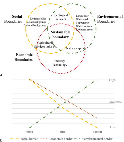
This study follows a multi-criteria methodological approach in accordance with the sustainable development principles cited previously. We highlight the environmental factors as a significant, yet neglected, aspect of the TAR processes. Our objective is to test the land cover data set as an environmental factor which might serve as a measure to criticize and improve the current, local administrative reform in Albania (Figure )). The study utilizes Geographic Information Systems (GIS) technologies as a tool for the data management and analysis.
Figure 2. Conceptual diagram of sustainable boundary derived from multi-criteria boundary dynamics (a); and Hypothetical impact rates of social, economic, and environmental factors at urban, rural and natural context (b).
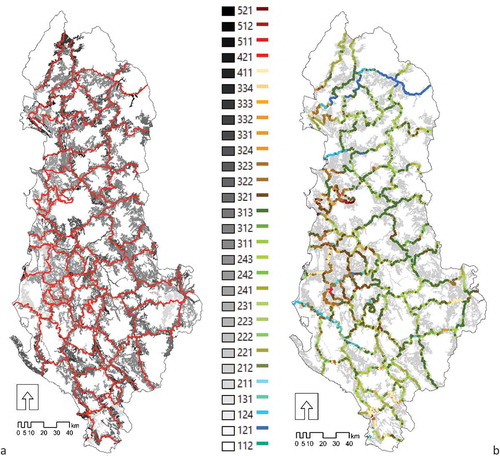
In the first part of this empirical study, we assess the landscape fragmentation resulting from the new local administrative map of Albania. Furthermore, the numerical data on the count and surface area of intersected CLC patches split via local administrative boundaries present information about spatial coverage distribution of fragmented land cover surfaces (Figure ). This step aims to validate our hypothesis: a TAR process neglecting the environmental concerns during the decision-making stages, leads to function-wise fragmented natural landscapes.
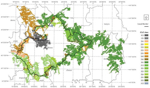
Figure 3. CLC patches intersecting with local administrative borders (a); and local administrative borders by their land cover type matching (b).
In the second part, we propose a new alignment for the administrative boundary of the Albanian capital, Tirana. Assuming that the TAR process has significantly considered the socio-cultural and economic criteria, we put forward the land cover pattern as a boundary defining reference to reduce the landscape fragmentation. The landscape patches intersecting with the actual borders are the core focus of the study, leading to a modified administrative boundary line. The alteration follows two rules: (i) the new border should track the land cover patch boundary it overlaps with and (ii) the smaller (in terms of area) parts of split patches, should spatially transfer to the neighboring administrative unit already containing the largest portion (Figure ).
Figure 4. Conceptual model for boundary definition via CLC; (a) landscape mosaic in a territory facing TAR, (b) border defined via socio-economic criteria between administrative units A and B and fragmentation of patch x and y, (c) transference of smaller split patches, and (d) the final boundary.

3.1. Multi-criteria framework for sustainable territorial and administrative reform
The environmental factors complement the socio-cultural and economic criteria, all of which comprise the sustainable management of the territory. However, the TAR decision-making processes either refer minimally or totally neglect the environmental ones. We posit that the environmental criteria when taken in consideration in a TAR process leads to a sustainable management of cross-border natural landscapes. Our approach (Figure ) follows the “sustainable landscapes” notion, standing as a holistic as well as anthropocentric model, considering the social, economic, and environmental dimensions of the landscapes all at once (Blaschke, Citation2006). Landscape sustainability is strongly related with both the ecological and community scales. Yet, an obstacle in achieving sustainable landscapes is the discordance between responsibility boundaries among agencies or stakeholders (Saunders & Briggs, Citation2002).
Figure ) presents a conceptual scheme of sub-criteria distribution per each main category (social, economic, environmental) according to their shared fields of relevancy. For example, we categorize the demographical data, social, and cultural background within the social criteria boundaries. Similarly, industry, commerce, and technology fall under the economic factors. Furthermore, we consider the land cover, watershed, topography, water features, and protected areas as environmental features of the territory. Besides, certain shared criteria fall within the common ground of two main sets. For instance, a common criterion across the economic and environmental factors is the natural capital. Similarly, we propose the ecological services as a shared factor of social and environmental, whereas the agricultural activity falls within the common ground of social and economic criteria.
Further analyzing the criteria by their relative significance weight at different spatial scales and context, like urban, rural, and natural, we state that the socio-cultural and economic factors are primarily more decisive in the urban context (Figure )). The aforementioned factors, predominantly associate with anthropogenic dynamics, which are spatially concentrated around the urbanized areas of the local administrative units, whereas the environmental criteria are more influential in the rural and natural environments extending in the municipal territories’ peripheral areas. Although our hypothetical assumption might motivate future studies on the issue, it stands on the same line with the distribution scheme of each criterion to TAR process stages as proposed in Table .
Table 1. Multi-criteria framework presented by their relevance to decision-making process stages of TAR
The proposal outlines three main stages of the TAR process: (i) defining the number and the local administrative units’ centers locations, as a macro-scale judgment, (ii) defining each unit’s hinterland, as a mezzo-scale finding, and (iii) defining the local, administrative boundary lines, as a micro-scale decision. Referring to Table , the socio-cultural and economic criteria are concentrated in the Stage 1 and the Stage 2, supporting the hypothesis in Figure ), while, the environmental factors are predominantly present in the Stage 2 and the Stage 3 of TAR process. Finally, by taking into account all the criteria, we promote a condition which defines new administrative borders that conform the sustainability principles.
3.2. Measuring landscape fragmentation caused by territorial division of administrative reform
The recent Albanian TAR process is performed within the scope of the decentralization policies in post-socialist countries. It generated a new map of local administrative organization by reducing the number of units from 374 to 61. Principally, the shrinkage in number of the administrative units, thus their amalgamation or territorial upscaling (Askim, Klausen, Vabo, & Bjurstrøm, Citation2017) in the scope of TAR, stands effective in reducing the landscape fragmentation within the territory (Ojima & Chuluun, Citation2008). However, if TAR does not consider the environmental features of the territory, it cannot guarantee the minimum fragmentation among natural lands. In this study, we experiment with CLC data as a mean to assess the landscape fragmentation caused by the TAR. We analyze the spatial relation among the land cover patches and the local administrative borders as illustrated in Figure .
Land cover properties of a territory may give reliable facts on the state of its natural assets. Previous studies (Zhang, Zhao, Liu, Liu, & Li, Citation2015) use the land cover statistics to analyze the changes of the natural capital through certain temporal sequences due to land use alterations. In our study, we employ the land cover statistics to assess and discuss the landscape fragmentation caused by the new administrative reform in Albania. The fragmentation analysis relies on the intersection condition between the CLC data and post-reform local administrative map as illustrated in Figure ). We ground our findings on the statistical results from the cross-split operation between both data. First, the statistics about the length of local administrative boundaries split through the overlapping CLC patches (Figure )) highlight the borders in conflict with natural land surfaces. The assessment expands by measuring the surface areas of split land cover patches overlapping with the local administrative boundaries.
3.3. Land Cover Data as Environmental Criterion in Deciding the Borders of the Local Administrative Units
The geography literature defines landscape as the external surface of the earth beneath the atmosphere, and merely being an outward manifestation of the factors at work in the area (Hartshorne, Citation1939). The study introduces land cover data as an evidence of the landscape surface properties, which might be utilized as an environmental parameter during decision-making processes of TAR.
Our experiment relies on CLC data, which provide structured typological spatial information on the land cover classified under specific categories. CLC nomenclature is organized in three hierarchical levels of surface cover types. The first divides the land surfaces into five main categories; artificial surfaces, agricultural areas, forests and semi-natural areas, wetlands, and waterbodies (Büttner & Kosztra, Citation2017). Finally, CLC provides information about land coverage properties under 44 classes of the third level. Open source spatial data derived from EIONET database provide useful spatial information about the land cover types of 6 years intervals. In this study, we decided to proceed with the data of 2012, as they coincide with the timeline of the recent TAR decision-making process performed in Albania, between 2013 and 2014. As presented in the multi-criteria framework, we applied the land cover data especially during the local administrative boundary definition phase.
In this study, we discuss the boundary concept referring to Finch’s articulation. The first one is based on the natural features of the context, which he calls “eternal,” caused by the “physical geography of the soil.” It is equivalent to the “antecedent boundary” concept theorized by Hartshorne in his evolution of boundaries theory (Dikshit, Citation1975). The second is the “variable” as caused by the “power of man” (Finch, Citation1833). In our research, we first borrow the dichotomy between natural and manmade, during the division of CLC classes into two groups of land cover surfaces. The artificial (CLC-100) and agricultural lands (CLC-200) are classified as surfaces transformed via anthropogenic factors, whereas forests and semi-natural areas (CLC-300), wetlands (CLC-400), and water bodies (CLC-500) are categorized as natural surfaces demarcated by eternal boundaries.
The conceptual dichotomy leads the study to highlight two aspects of the multi-criteria frame, as the most definitive input while deciding the boundary line between two local administrative units. First, the boundary condition between two artificial land cover patches belonging to their respective adjacent administrative units can be defined as a border line based on the socio-cultural and economic criteria, such as private property. We accept the property lines as definitive indicators of the local administrative boundary dividing the artificial surfaces. As we assume that TAR considers all the socio-cultural and economic factors, including the property rights, the actual municipal borders passing through artificial land cover patches are considered successful, thus, outside the scope of this work.
However, we propose that the border line passing among natural lands should track according to the land cover pattern, following certain rules. The procedure starts with the identification of the existing overlapping condition between the municipal borders of the reference map (post-reform local administrative map of Albania), and the natural landscape patches as derived from CLC data of 2012 (Figure ). Via a split operation, we subdivide the cross-border patches into at least two components (x and y) falling inside different adjacent administrative units (A and B) (Figure )). Figure illustrates diagrammatically the fundamental rule of the proposal: the smaller (in surface area) split patches are combined with their larger sibling patch, thus being spatially transferred to the neighboring administrative unit (Figure )). Finally, the new local administrative border should follow the boundary line of the patch it previously split through (Figure )).
3.4. Utilizing GIS technology in boundary definition of local administrative units
The study utilizes ArcGIS 10.2.2 software during the empirical steps of the research. Initially, we assess the landscape fragmentation generated by the new layout of administrative map, via spatial statistics in ArcMap. Apart from the default toolbox of ArcGIS package, the research applied two extension tools. As a first step, the ModelBuilder utility automates the process of generating the map of split cross-boundary landscape patches. ModelBuilder utilization varies; however, in this research, we customize it as a unique tool according to the goals of our study (Allen, Citation2011). The workflow of the model relies on two input variables: (i) the local administrative map and (ii) CLC data (shp). The model produces a new polyline shapefile presenting an improved version of the reference administrative borders’ map following the rules explained before. Furthermore, we applied the Matrix Green toolbox (Bodin & Zetterberg, Citation2010) while preparing the island-free patches of transferred landscape surfaces, as the patches to be reclassified may consist of other patches within them. In such cases, all island patches face the same transfer with the patch they fall within.
4. Results & discussions
We organize the results of this research into two main tiers. First, it delivers information about the landscape fragmentation caused by the current, local administrative borders with an emphasis on the natural landscapes. Second, it presents a revised version of the municipal borders of Tirana, based on the unique pattern of the natural land cover mosaics. Finally, we discuss significant drawbacks as further development of the work presented in this article.
4.1. Measuring landscape fragmentation caused by TAR in Albania
The overlapping condition between administrative boundaries and land cover patches provides ground for the assessment of functional landscape fragmentation caused by the new TAR in Albania. First, we use the “selection by location” tool in ArcMap, to filter CLC patches that intersect with the local borders’ lines. As a result, we derive numerical information about the number of patches (count) and their surface area as illustrated in the Table . Next, local boundary polyline feature split by the geometry of the filtered CLC patches provides statistical evidence about the total border length per land cover type. Further on, the filtered CLC polygons split by the polyline feature of the local borders, prepare the spatial basis for the local boundary definition method as explained in Figure .
Table 2. Statistics of landscape patches being fragmented by administrative borders
Table illustrates that 74% of new administrative borders overlap with natural surfaces. Referring to the same evidence, the list of border length per land cover type is headed by boundaries crossing, broad-leaved forests (CLC-311), natural grasslands (CLC-321) and transitional woodland-shrub (CLC-324), comprising about 43% of the total boundary length. Comparing percentage distribution of borders length and land cover patch count values, the highest difference belongs to broad-leaved surfaces (19.27%—11.72%), water courses (3.14%—0.61%), and water bodies (3.31%—0.66%). These numbers are on the same line with the average length values per surface type, respectively, being: 2.8, 8.7, 8.5 km. The high rates of broad-leaved surfaces indicate that the forested landscape patches are larger in surface area in comparison with other land cover types, resulting in longer border lines they overlap with.
The numerical data of Table in accordance with the visual information in Figure ), point out a possible consideration of the water resources as decision-making criteria during the last TAR process in Albania. According to the statistical data in Table and Figure , 113 km of administrative borders overlap with watercourses (CLC-511, southern Albania) and 119 km are tracking through waterbodies (CLC-512, northern Albania). This fact implies a sharing of the freshwater resources among neighboring administrative units. Although water sources are among the only environmental criteria relatively considered during the reform, unfortunately it is not explicitly included in the technical report of TAR.
While, three quarters of the total administrative borders are overlapping with the natural land cover surfaces, the remaining 26% of local administrative boundaries cross over artificial (CLC-100) and agricultural (CLC-200) surfaces. More precisely, agricultural surfaces dominated by complex cultivation patterns (CLC-242) and non-irrigated arable land (CLC-211), overlap with 24% of total administrative borders. The remaining 2% of the total administrative borders overlap with the artificial surfaces, which are dominated by discontinuous urban fabric (CLC-112), industrial and commercial units (CLC-121), and mineral extraction sites (CLC-131).
The dominance of natural landscapes and the minimal presence of artificial surfaces intersecting administrative borders might serve as a validation to the hypothesis illustrated in Figure ) and the Table . Accordingly, we might assert that the environmental criterion is the most significant drive during the Stage 3 or boundary definition phase, specifically at the rural context. As a consequence, the results show that the TAR processes of Albania which apparently neglected the environmental properties of the territory have led to extensive functional fragmentation, particularly among natural landscapes.
4.2. CLC data as reference for defining the boundaries of local administrative units
Beyond the conceptual approach and the assessment of landscape fragmentation caused by the new administrative division under the recent TAR in Albania, the study makes a demonstrative case of readjusting the municipal borders of the capital city, Tirana (Figure ). The experiment stands on the assumption that if the existing version of local administrative map was an output of a process that has significantly considered the socio-cultural and economic features of the context during the decision-making process of TAR, then the land cover data as an environmental criteria are proposed as the final step of local boundary definition/refinement stage as conceptually targeted in the Table . Based on this postulation, the boundaries dividing two artificial surfaces are considered successful, consequently, out of the scope of the experiment.
Figure 5. Location of Tirana municipality (a) and the shared municipal borders overlapping with CLC patches (b).
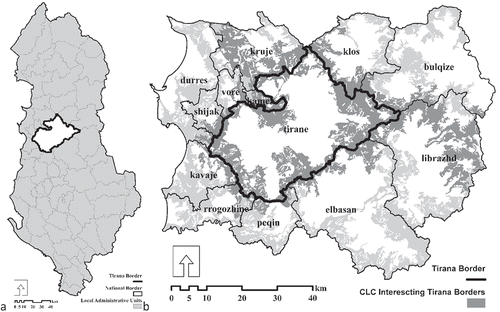
The focus of the alteration are the border segments of the recent administrative map of Tirana municipality (Figure ) that overlap with the natural lands of CLC data. The borders crossing over artificial land surfaces are excluded, since, as proposed in the multi-criteria framework, the boundaries of artificial and agricultural land cover surfaces are dictated by the cadastral property line rather than the land cover pattern of their mosaic. Furthermore, if urbanized areas (CLC-112), as shown in Figure , are considered within the readjustment process, it results in transferring of the adjacent smaller urbanized zones causing a total cancellation of the neighboring administrative unit. Since the consequence is in conflict with the socio-cultural criteria of the Stage 1 and the Stage 2 of the multi-criteria framework (Table ), the urbanized and artificial land cover surfaces are excluded from the readjustment procedure.
Figure 6. CLC patches intersecting with the current municipality borders of Tirana.
According to the overlapping operation between CLC data of 2012 and Tirana municipality border line, there are 143 cross-border land cover patches shared among Tirana and other neighboring municipalities (Figure ). Among patches split by local administrative border, 49 are artificial surfaces covering an area of 38,265 ha (31%). The remaining 94 patches are natural lands of a total area of 84,707 ha (69%). According to the above-mentioned rationale, in the further steps of the experiment, the artificial surfaces are excluded. First, the natural land cover surfaces (CLC-311; CLC-312; CLC-321; CLC-323; CLC-324; CLC-331; CLC-333; CLC-512) are filtered from the set of patches intersecting the administrative borders of Tirana (Figure ). The selected natural patches are split via the current administrative border line. A comparison among split parts of each cross-border natural land cover patch is performed, to identify the smaller portions to be deported to the neighboring administrative unit consisting the larger part. This condition is based on the rules of the proposed method, where the smaller fragments of split patches have to be joined with the largest sibling portion (Figure ).
Figure 7. Import and export of cross-border natural landscape patches in case of Tirana.
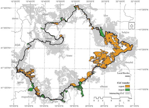
According to the map shown in Figure and numerical data included in Table , Tirana is exporting 38 patches (orange) of natural land cover with a total area of 13,825 ha. On the other hand, Tirana is importing 56 patches (green) covering 3003 ha of surface area. As it is shown in Figure , the largest patch to be exported located in the eastern corner of the municipal border consists of certain island patches within it (indicated by “x” in Figure ). These areas are accepted to be transferred following the destination of the same patch they spatially fall within. Thus, if the island areas are included, the total exported area is updated to 15,103 ha, implying for an island lands of 1300 ha. Consequently, according to the proposed methodology, Tirana municipal surface area is decreased by 12,100 ha, which makes about 11% of the total municipal surface area.
Table 3. Statistics of imported and exported landscape patches according to new proposal of Tirana Municipality borders
5. Discussion and further improvements
First, considering that the process results in patches to be imported and exported simultaneously, one may expect a certain balance in the cumulative change of the local administrative territories’ surface areas. In this context, referring to the results of the study, the reduction of the surface area of Tirana municipal territory by 11%, in principle, is beyond the expectation. This dominant difference between imported and exported patches is dictated by a special case of the largest exported surface in the eastern part consisting of broad-leaved forested areas (CLC-311). The patch alone has an area of 9677 ha (about 9% of the total municipal area). At the same time, it is a smaller portion of a large cross-border patch (ID = “AL-10,469”), which covers a total surface area of 29,115 ha and is concurrently split among four neighbor administrative units. Moreover, a major part of this patch is part of national protected areas being subject of central government management. Considering these reasons, the patch “AL-10,469” and similar other patches might be excluded from the transferring procedure, consequently improving the results of the study.
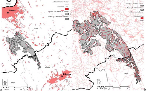
Furthermore, the modified municipal border might result in conflict with the other criteria, the socio-cultural or economic properties of the territory. For instance, such a conflict emerges in case when the smallest (in terms of surface area) portion of a cross-border natural landscape patch has a linear layout perpendicular to the splitting border by continuing deep into the central territory of the administrative unit (Figure ). This is due to the fact that the transferred patch may overlap with crucial elements such as local transportation network, cultural heritage sites, rural settlements that traditionally may be connected with the other urban center. Consequently, the paper calls for further research on analyzing these conflicting cases. To avoid similar divergences, the methodology might improve by bringing other restricting parameters such as surface area, shape of patch, the national scale interest, and status of large patches.
Figure 8. Patch ID = AL-10,460 in relation with urban centers (a) and with rural settlements and transportation network (b).
Finally, we acknowledge a possible contradiction between the rigid form of the administrative boundaries and the evolving character of land cover properties of the territory. As previous studies have shown, the transformation of land cover pattern of the territory within a relatively short period of time does not only result out of anthropogenic reasons, but also by changes in the systemic cycles in the natural environment such as global climate change (Davidson et al., Citation2012) or ecological succession (Alonso & Sole, Citation2000; Parker, Mans, Janssen, Hoffmann, & Deadman, Citation2003). The concept of dynamic local administrative boundary might be elaborated as a further step of the study.
6. Conclusions
This paper demonstrates a case of the local administrative boundaries re-organization, based on land cover data introduced as a territory’s environmental feature. Principally, the methodology relies on a proposed multi-criteria framework, which consists of socio-cultural, economic, and environmental features of the context. The multi-criteria framework aims at providing a comprehensive structure for considering the complete properties of a territory undergoing the process of TAR.
The results of the study show that a local administrative division process which disregards the environmental factors of the territory leads to functionally fragmented landscapes. The fragmentation consists of a division of responsibilities and interest on a certain landscape patch as a natural capital asset, among different administrative units. In the long run, this practice is forecasted to lead to uncoordinated changes in the landscape structure, thus potentially resulting in physically fragmented landscapes.
The study has shown that the fragmentation among the landscape patches minimizes when TAR processes consider the land cover properties of the territory, thus the landscape mosaic structure is a decisive criteria during the local administrative boundary definition phase. The proposed method generates a different administrative division which avoids any condition of cross-border natural landscape patches. Hence, the landscape fragmentation significantly reduces at the CLC data scale. While the method results successful in most of the small- and moderate-sized land cover patches, it is debatable in conflicting cases between large natural landscape patches and the socio-economic priorities of region.
The study proposes a multi-criteria framework highlighting the environmental features of the territory facing TAR processes, along with the socio-cultural and economic, converging with the principles and goals of sustainable development. The proposed method for defining the local administrative borders based on multi-criteria basis by utilizing land cover data can be applied in future TAR processes, especially in post-socialist countries. Finally, the CLC data provided an appropriate spatial information to define the local boundary based on sustainable land management principles, within the scope and objectives of TAR.
Acknowledgements
The authors are grateful to the European Environment Agency, for providing the open source Corine Land Cover data utilized as the raw material of the presented model. Further on, the authors are grateful to Hayriye Eşbah Tunçay and B. Niyami Nayim for their continuous guidance. This research study has been made in support of the PhD thesis of the contact author in the Graduate School of Science, Engineering, and Technology at Istanbul Technical University.
Additional information
Funding
Notes on contributors
Artan Hysa
Artan Hysa is an architect by education. He is a PhD candidate at Istanbul Technical University, Department of Landscape Architecture, currently being at the very final stage of his doctoral studies. This article is prepared within the scope of his PhD dissertation entitled “Utilizing CORINE Land Cover in Diverse Spatial Decision Making and Management Processes.” His research activity is driven by an interest on the utility of cross-disciplinary knowledge in problem-oriented research.
Fatma Ayçim Türer Başkaya
Fatma Aycim Turer Baskaya is an associate professor at Istanbul Technical University, Department of Landscape Architecture. She is the coordinator of the landscape architecture master and PhD programs at the Graduate School of Science, Engineering and Technology, ITU. Her research areas are Coastal Landscape Planning and Design, Disaster Sensitive Landscape Architecture, Landscape Reclamation and Restoration, and GIS Based Landscape Studies.
References
- Allen, D. W. (2011). Getting to know ArcGIS modelBuilder. Redlands: Esri Press.
- Alonso, D., & Sole, R. V. (2000). The DivGame simulator: A stochastic cellular automata model of rainforest dynamics. Ecological Modeling, 133(1/2), 131–141. doi:10.1016/S0304-3800(00)00287-8
- ASIG. (2015, June 1). Administrative Units Layer. Retrieved September 14, 2017, from: https://geoportal.asig.gov.al/map/
- Askim, J., Klausen, J. E., Vabo, S. I., & Bjurstrøm, K. (2017). Territorial upscaling of local governments: A variable-oriented approach to explaining variance among Western European countries. Local Government Studies, 43(4), 555–576. doi:10.1080/03003930.2017.1310102
- Blaschke, T. (2006). The role of the spatial dimension within the framework of sustainable landscapes and natural capital. Landscape and Urban Planning, 75(2), 198–226. doi:10.1016/j.landurbplan.2005.02.013
- Bodin, Ö., & Zetterberg, A. (2010). MatrixGreen user’s manual: Landscape ecological network analysis tool. Retrieved September 2016, from http://www.stockholmresilience.org/.
- Buttimer, A. (Ed.). (2001). Sustainable landscapes and lifeways: Scale and appropriateness. Cork: Cork University Press.
- Büttner, G., & Kosztra, B. (2017). CLC2018 technical guidelines. Wien: European Environment Agency.
- Costanza, R., d’Arge, R., de Groot, R., Farber, S., Grasso, M., Hannon, B., & van den Belt, M. (2016). The value of the world’s ecosystem services and natural capital. In P. Newell (Ed.), The globalization and environment reader (pp. 117–134). West Sussex: John Wiley & Sons.
- Costanza, R., Kubiszewski, I., Ervin, D., Bluffstone, R., Boyd, J., Brown, D., … Yeakley, A. (2011). Valuing ecological systems and services. F 1000 Biology Reports. doi:10.3410/B3-14
- Davidson, E. A., de Araújo, A., Artaxo, P., Balch, J. K., Brown, F., Bustamante, M. M., … Wofsy, S. C. (2012). The amazon basin in transition. Nature, 481(7381), 321–328. doi:10.1038/nature10717
- De Peuter, B., Pattyn, V., & Wayenberg, E. (2011). Territorial reform of local government: Evaluation criteria underpinning decisions and debate in Flanders. Local Government Studies, 37(5), 533–552. doi:10.1080/03003930.2011.604546
- Dikshit, R. D. (1975). Political geography: The spatiality of politics. New York: McGraw-Hill Publishing Company.
- Finch, I. (1833). Power of man over boundaries. In I. Finch (Ed.), Travels in the United States of America and Canada: Containing some account of their scientific institutions and a few notices of the geology and mineralogy of those countries (pp. 419-421). London: Longman.
- Ghinea, A., & Moraru, A. (2006). Aspects regarding decentralization process in Romania, The Administrative Territorial Reform. Bucharest: Institute for Public Policy. Retrieved September 7, 2017, from http://www.ase.md/files/catedre/mgs/Decentralization_Process.pdf
- Giovannoni, E., & Fabietti, G. (2013). What is sustainability? A review of the concept and its applications. In C. Busco, M. L. Frigo, A. Riccaboni, & P. Quattrone (Eds.), Integrated reporting; Concepts and cases that redefine corporate accountability (pp. 21–40). Switzerland: Springer International Publishing.
- Gordon, A., Bastin, L., Langford, W. T., Lechner, A. M., & Bekessy, S. A. (2013). Simulating the value of collaboration in multi-actor conservation planning. Ecological Modelling, 249, 19–25. doi:10.1016/j.ecolmodel.2012.07.009
- Guerrero, A. M., Mcallister, R. R., & Wilson, K. A. (2014). Achieving cross-scale collaboration for large scale conservation initiatives. Conservation Letters, 8(2), 107-117.
- Hartshorne, R. (1939). The nature of geography: A critical survey of current thought in the light of the past. Lancaster, Pennsylvania: Association of American Geographers.
- Harvey, S., & Most, B. A. (1976). The substance and study of borders in international relations research. International Studies Quarterly, 20(4), 581–620. doi:10.2307/2600341
- HELVETAS. (2016). The Inter-sectorial Strategy for Decentralisation of Local Government: Monitoring Report for July 2015- August 2016. Tirana: The Minister of State for Local Affairs. Retrieved September 26, 2017, from http://www.ceshtjetvendore.gov.al/files/pages_files/Raporti_i_Monitorimit
- Hens, L. (1996). The Rio Conference and thereaft. In L. Hens & D. Devuyst (Eds.), Sustainable development European Centre for Pollution Research (pp. 81–109). Brussels: Free Univer- sity of Brussels and UN Educational Scientific and Cultural Organisation VUB Pres. doi: 10.1016/S0940-2993(96)80099-6
- Hoffman, L. L., Varady, R. G., Flessa, K. W., & Balvanera, P. (2009). Ecosystem services across borders: A framework for transboundary conservation policy. Frontiers in Ecology and the Environment, 8(2), 84–91. doi:10.1890/070216
- Hysa, A. (2018). Land cover statistics as a measure of natural capital distribution fairness among altered administrative territorial divisions. International Journal of Applied Statistics and Econometrics, 1(1), 48–61.
- Jantke, K., & Schneider, U. A. (2010). Multiple-species conservation planning for European wetlands with different degrees of coordination. Biological Conservation, 143(7), 1812–1821. doi:10.1016/j.biocon.2010.04.036
- Kark, S., Tulloch, A., Gordon, A., Mazor, T., Bunnefeld, N., & Levin, N. (2015). Cross-boundary collaboration: Key to the conservation puzzle. Current Opinion in Environmental Sustainability, 12–24. doi:10.1016/j.cosust.2014.08.005
- Krasniqi, A. (2014, July 19). ORANEWS. RetrievedSeptember 07, 2017, from http://www.oranews.tv/analiza/reforma-territoriale-produkt-i-pazareve-politike/
- Kreci, V., & Ymeri, B. (2010). The impact of territorial re-organisational policy interventions in the republic of Macedonia. Local Government Studies, 36(2), 271–290. doi:10.1080/03003930903560646
- Kuhlmann, S., & Wollmann, H. (2011). The evaluation of institutional reforms at sub-national government levels: A still neglected research Agenda. Local Government Studies, 37(5), 479–494. doi:10.1080/03003930.2011.604542
- Mace, G., Balmford, A., Boitani, L., Cowlishaw, G., Dobson, A., Faith, D. P., & Gaston, K. J. (2000). It’s time to work together and stop duplicating conservation efforts. Nature, 405, 393–493. doi:10.1038/35013247
- MEA. (2016, June 09). Forest fund legislation. Retrieved February 25, 2017, from Ministry of Environment of Albania: http://www.mjedisi.gov.al/files/userfiles/Pyjet/Udhezimi_Nr._1_Date_09.06.2016_merged.pdf
- MLA. (2014, March 06). albanian administrative- territorial reform; Technical criteria. Ministry of Local Affairs. Tirana: Author. Retrieved March 06, 2017, from http://www.reformaterritoriale.al/images/presentations/KRITERETTEKNIKEPROPOZIMIPERKOMISIONIN_28Prill2014.pdf
- Ndreu, A. (2016). Implementation of the administrative- territorial reform for a sustainable development of the economy in Albania. Social and Natural Sciences, 10(1), 1–4.
- Norton, A. (1994). International handbook of local and regional government: A comparative analysis of advanced democracies. Cheltenham, UK: Edward Elgar Pub.
- Ojima, D., & Chuluun, T. (2008). Policy changes in Mongolia: Implications for land-use and landscapes. In K. A. Galvin, R. S. Reid, R. H. Behnke Jr, & T. N. Hobbs (Eds.), Fragmentation in Semi-Arid and Arid landscapes: Consequences for human and natural systems (pp. 179–193). Dordrecht, The Netherlands: Springer.
- Ostrom, E. (2010). The challenge of common-pool resources. Science and Policy for Sustainable Development, 50(4), 8–21.
- Parker, D. C., Mans, S. M., Janssen, M. A., Hoffmann, M. J., & Deadman, P. (2003). Multi-agent systems for the simulation of land-use and land-cover change: A review. Annals of the Association of American Geographers, 93(2), 314–337. doi:10.1111/1467-8306.9302004
- QBZ. (2014, September 1). Retrieved from Center of Official Publications: http://www.qbz.gov.al/botime/fletore_zyrtare/2014/PDF-2014/137-2014.pdf
- Reçi, S., & Ymeri, I. (2016). Administrative and territorial reform in Albania and the issue of decentralization: Comparative overview of relevant international legislation. Academic Journal of Business, Administration, Law and Social Sciences, 2(1), 175–183.
- Saltmarshe, D. (2001). Developments in Albanian Local Government. Local Government Studies, 27(2), 111–129. doi:10.1080/714004100
- Saunders, D. A., & Briggs, S. V. (2002). Nature grows in straight lines—Or does she? What are the consequences of the mismatch between human-imposed linear boundaries and ecosystem boundaries? An Australian example. Landscape and Urban Planning, 61, 71–82. doi:10.1016/S0169-2046(02)00103-2
- Steenmans, C. (2016). Foreword. In J. Feranec, T. Soukup, G. Hazeu, & G. Jaffrain (Eds.), European landscape dynamics: CORINE land cover data (pp. xi–xii). Boca Raton: CRC Press.
- Swianiewicz, P. (2010). If territorial fragmentation is a problem is Amalgamation a solution an east european perspective. Local Government Studies, 183–203. doi:10.1080/03003930903560547
- Wollmann. (2010). Territorial local level reforms in the East German Regional States (Länder): Phases, patterns, and dynamics. Local Government Studies, 36(2), 251–270. doi:10.1080/03003930903560612
- Zhang, Y., Zhao, L., Liu, J., Liu, Y., & Li, C. (2015). The impact of land cover change on ecosystem service values in Urban Agglomerations along the coast of the Bohai Rim, China. Sustainability, 7(8), 10365–10387. Retrieved 2017 doi: 10.3390/su70810365