
 ?Mathematical formulae have been encoded as MathML and are displayed in this HTML version using MathJax in order to improve their display. Uncheck the box to turn MathJax off. This feature requires Javascript. Click on a formula to zoom.
Abstract
In conventional aviation, flight route planning aims to guarantee security and reduce the operating costs of the different types of aircraft that are currently available. This paper presents and analyses the results obtained from planning a flight route in real time for short-range aircraft fitted with geared turbofans with a constant volumecombustor to reduce operating costs by optimizing the route in terms of less distance traveled. In the analysis, an off-line route obtained from a flight profile using the Preliminary Multidisciplinary Design Framework tool is compared with the same route that is run in real time using a route planner optimized with a particle swarm optimization algorithm. The average results indicate that the route proposed by the optimization algorithm reduces direct and indirect operating costs if compared to the alternative route (traditional approach according to flight plan). This is mainly due to the lower fuel consumption and maintenance costs when selecting an optimized route. In cases where direct and alternate routes are completely obstructed, the planner can find an optimized route based on the lower costs. In this way, the pilot and the flight controller on the ground can make the decision whether to risk the aircraft with passengers on a route with adverse weather conditions or to have an optimized and safe one. The use of this type of route optimizer leads to significant benefits with respect to aircraft environmental taxes for emissions and noise, and increases aviation safety. This finding indicates that the route planner is a suitable support option when the course of an aircraft must be changed to follow a different route than the suggested alternative.
Public Interest Statement
In conventional aviation, flight route planning aims to guarantee security and reduce the operating costs of the different types of aircraft. This paper presents the outcomes obtained from planning a flight path for an aircraft with regards to less operational costs using a simulation tool, and then are compared to business-as-usual approach (flight plan). The average results indicate that the simulated route reduces the operational costs if compared to the business-as-usual approach. This is mainly due to the lower fuel consumption and maintenance costs when selecting an optimized route. In this way, the pilot and the flight controller on the ground can make the decision whether to risk the aircraft with passengers on a route with adverse weather conditions or to have an optimized and safe one. The use of this type of route optimizer leads to significant benefits with respect to aircraft environmental taxes and increases aviation safety.
1. Introduction
An aerial system is a network of interconnected systems that includes human resources, operation procedures and certifications, routes, no-fly zones and all equipment used to provide safe air navigation services. The routes that are commonly referred to as airways are nominal routes that have a protected area that enables an aircraft to fly along a safe path at a safe altitude. In addition, the aviation authority sets the controlled and non-controlled airspace depending on the type of systems. For example, air traffic services may fully or partially prohibit flying per Visual Flight Rules (VFR), which establish the necessary conditions for a pilot to steer an aircraft, navigate and maintain a safe distance from any obstacle, only by sight (Anon, Citation2014; ICAO, Citation2009).
In this sense, the route planning is one of the most important factors in civil aviation since it is directly related to fuel consumption, pollutant emissions to the atmosphere, operating costs and aviation safety. A flight route is a set of geographic coordinates that an aircraft must follow to travel from a departure point to a destination point. Four key sectors exist in the aircraft world: commercial aviation, military aviation, cargo and short- and long-range unmanned aerial vehicles. In this context, the increase in the number of aircraft in operation causes the need to define new routes and to optimize flight plans based on aviation safety, the reduction of operating costs and of polluting emissions (Mason & Miyoshi, Citation2009).
The need for new routes and optimizing the flight space, proposes new challenges in the formulation of techniques and algorithms for the planning and optimisation of routes. That is, to find the different directions an aircraft must follow to reach its destination. The route planning algorithm obtains the points between each coordinate while considering a series of restrictions that are imposed by the environment or the mission (Meng & Xin, Citation2010; Peng & Li, Citation2012). Route planning algorithms are divided into two groups: algorithms that undertake the planning online and algorithms that plan offline (Xue, Cheng, & Cheng, Citation2014). Offline route planning is a technique that is specific to civil aviation, in which pre-established routes exist (Aeronáutica Civil Colombiana, Citation2015; International Civil Aviation Organization, Citation2006) and course corrections directly depend on flight controllers on the ground that transmit data to an aircraft (Jardin, Citation2003). Route planning in conventional aviation is based on optimizing fuel consumption with regard to a shorter distance traveled taking into account the cruise altitude (Jensen, Hansman, & Venuti, Citation2014; Xu, Andrew Ning, Bower, & Kroo, Citation2014). In Wang, Yin, Zhang, and Yu (Citation2014) propose a multi-objective optimization technique to analyze emissions and the cost of operation during the design stage of the aircraft. In Murrieta-Mendoza, Botez, and Félix Patrón (Citation2015) propose a method based on genetic algorithms to analyze the coordinates available in the flight plan to determine the altitudes that minimize the total fuel consumption taking into account the cruising stages, ascend and descend.
This paper proposes a method for route planning using an algorithm inspired by particles swarms, in order to reduce the direct operating costs of short-range aircraft powered by turbofan with a constant volumecombustor. The selection of the algorithm was based on the good results obtained with this method in the solution of multi-objective optimization problems. Its evaluation in terms of quality of the solution and execution time on embedded systems of reduced computational capacity can be found in (Góez, Citation2016; Góez et al., Citation2016; Munoz, Llanos, Coelho, & Ayala-Rincon, Citation2010; Roberge, Tarbouchi, & Labonté, Citation2013; Tewolde, Hanna, & Haskell, Citation2009).
With regards to the particle swarm optimization (PSO), there are several works proposing variants of this algorithm aiming to improve its performance. Classic PSO variations are focused on introducing cognitive components to improve personal and social experience, complemented with the introduction of new restrictions. This type of techniques allows to dynamically controlling the PSO parameters. As a result, particles speed regulation is observed during the exploration, improving the algorithm performance (Jadoun, Gupta, Niazi, Swarnkar, & Bansal, Citation2015a, 2015b, 2015c). Another example of PSO variant is found in Jadoun, Gupta, Niazi, and Swarnkar (Citation2014) where the inertia operator of the PSO is modulated by entering a sinusoidal function. The obtained result shows an improved exploration of the search space.
Moreover, to validate the results found in the literature, this work also integrates the route planner taking as basis the search optimization algorithm Cuckoo. Cuckoo search is a relatively new optimization algorithm showing satisfactory results and low convergence times (Yang & Deb, Citation2014; Yang & Press, Citation2010).
2. Route planning using the developed algorithm
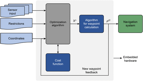
The proposed method for planning a route involves evaluating each possible path generated by the individual waypoints. This evaluation determines the coordinates of the best point obtained by the algorithm that evaluates all possible routes, where the new coordinate is employed as a direction vector as a basis for determining the new waypoint based on the cruising speed.
Figure , shows a block diagram of the route planning algorithm (Góez, Citation2016), where
| • |
| ||||
| • |
| ||||
| • | Database that corresponds to a matrix of the altitudes for each coordinate point H. | ||||
| • | Destination coordinates in latitude and longitude. | ||||
| • | Initial departure coordinates in latitude and longitude, which are updated with each new coordinate delivered by the route optimization algorithm. | ||||
Figure 1. Block diagram of the route planning algorithm.
2.1. Optimization techniques
2.1.1. Cuckoo (CK) search optimization
Cuckoo Search is a method based on the parasitic behavior of the cuckoos when it comes to depositing their eggs in other birds’ nests. Each possible solution of the problem is associated with the coordinates of a nest that is occupied. In this way, part of an initial set of nests in which an egg has been deposited. Among them, the best eggs will go unnoticed and survive, but the worst eggs will have a chance to be discovered by the owner of the nest and will be discarded. For the selection of new nests and completing the search space, the behavior of some fruit flies and birds is imitated. What shows a random flight that fits the so-called Lévy Flights. When generating new Xg + 1 solutions for an i-th cuckoo, a Lévy flight is generated and given by the following Equation (1):(1)
(1)
This type of flight is characterized by long straight line routes followed by abrupt changes of direction with 90 degree turns. The direction of the turn is evenly distributed and the size of the increase is established according to the following distribution of lévy, Equation (2).(2)
(2)
2.1.2. Particle swarm optimization (PSO)
Particle swarm optimization (PSO) refers to numerous methods and heuristic optimization algorithms that are reminiscent of the behaviors of swarms of bees in nature and the movements of large groups of insects or schools of fish. In these groups, the movements of each individual searching for an objective are investigated, with the advantage of some form of communication among individuals. Thus, each of their movements is driven by three variables: first, the experience of the best places visited to date; second, the best place discovered by another member of the swarm; and third, an inertia component of the previous movement that buffers the velocities of the particles (Lee & Kim, Citation2013).
Equation (3) expresses the particle velocity, whereas Equation (4) expresses the position of the i-th particle (Clerc, Citation2005; Leonard & Engelbrecht, Citation2013).(3)
(3)
Position of the i-th particle:(4)
(4)
The PSO parameters are as follows (Clerc, Citation2012):
| • |
| ||||
| • |
| ||||
| • |
| ||||
| • |
| ||||
| • |
| ||||
| • |
| ||||
| • |
| ||||
| • |
| ||||
| • | Stop method, minimum error reached by each member of the population. | ||||
Figure 2. Social behavior of the PSO algorithm (Góez, Citation2016).
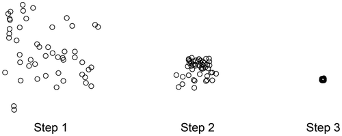
In this algorithm, each solution is associated with the coordinates of a point and the performance of each solution or point will be calculated using the objective function. The algorithm will begin with a cloud of points that will move in search of the best solutions until the optimum solution is reached.
2.2. Cost function
Route planning systems associate the best route with finding the shortest path. The cost function evaluates both the shortest distance to a destination coordinate and the specific air navigation features of an aircraft, such as maximum turning radius, true air speed (TAS), and flight altitude. In addition, restrictions are established based on the impossibility of flying over certain places due to either weather changes or other obstacles that require a new path and a new route.
Figure shows the components of the cost function.(5)
(5)
Figure 3. Cost function for route evaluation (Góez, Citation2016).
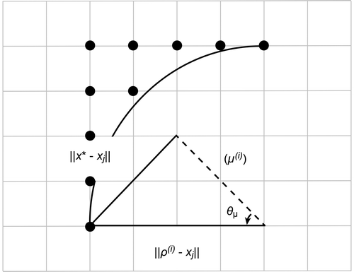
where,(6)
(6)
where , is the angle formed by the vector magnitude defined among coordinate
, which is the departure coordinate, the coordinate indicated by the direction vector
that the airplane follows at time i, and the coordinate
proposed by the particle in the i-th execution of the optimization algorithm.
3. Methodology
The simulations were performed using a database that encompasses an area from latitude 4.4029° N to 5.8860° N, and longitude −74.9069° to −76.3969° W, which corresponds to an altitude matrix size of 217*314. Table lists the flight parameters. First step, the route planner is compared using as a base PSO and CK separately. The quality of the solutions is compared. Second step, the planner is run with the PSO optimizer having as configuration parameters the flight characteristics of an A320. Third step, the flight profiles are obtained in direct route, alternate route according to the flight plan and the flight profile obtained with the distance traveled in the route delivered by the flight planner proposed in this work. The flight profiles and direct operating costs are obtained with the PMDF tool.
Table 1. Validation results
The Preliminary Multidisciplinary Design Framework (PMDF) tool was employed to obtain the reference cruising flight profile, which follows a straight line between two geographic coordinates. Figure shows a general view of the structure of the PMDF tool.
Figure 4. General description of the PMDF tool (Colmenares Quintero, Citation2009; Colmenares Quintero et al., Citation2010; Colmenares, Brink et al., Citation2009; Colmenares, Coutinho et al., Citation2009).
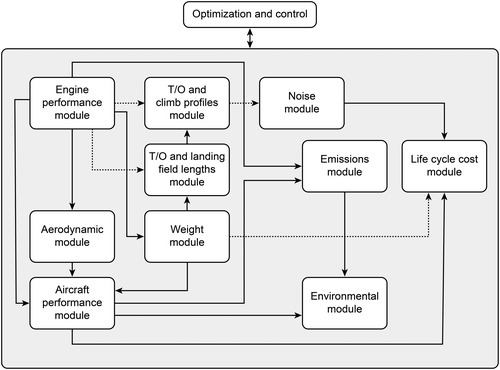
The PMDF computational tool has several interconnected modules that are linked to an optimization and control unit. These modules are briefly described in the next section.
3.1. Engine performance module
The engine performance module enables modeling the performance of a conventional and innovative turbine engine. The cycle analysis is based on a one-dimensional steady state model that combines several configurations of Mach number and altitude.
3.2. Aerodynamic module
This module is based on an empirical estimation technique that uses the “Delta Method” developed by “Lockheed” in cooperation with National Aeronautics and Space Administration (NASA).
3.3. Aircraft performance module
The weight and performance data of the engine are entered in this module. A user can program a cruise flight from ten options, including optimum altitude and/or Mach number.
3.4. Weight module
This module estimates the weight of an aircraft using empirical correlations. In addition, the weight module can calculate the center of gravity of an airplane and the moment of inertia.
3.5. Takeoff and landing field lengths module
The PMDF tool has an independent module to calculate takeoff and landing distances. The results comply with FAR Part 25 and/or MIL-STD-1793 regulations depending on the application.
3.6. Takeoff and climb profiles module
This module can calculate the takeoff and climb profile. Different profiles can be created since different power settings can be implemented.
3.7. Noise module
This module calculates the aircraft noise at an airport and the noise radiated to the community in compliance with FAR Part 36 regulations. The noise module generates noise footprints for airports.
3.8. Emissions module
The polluting emissions that are calculated in this module are carbon monoxide (CO), carbon dioxide (CO2), unburned hydrocarbons (UHC), water vapor (H2O) and nitrogen oxides (NOx). These emissions are determined through the Emissions Index (EI).
3.9. Validation and engine data
PMDF is validated with the data of an Airbus A320 mounted with CFM56-5 turbofan engines. A selection of validation results is listed in Colmenares Quintero et al. (Citation2010) (please, refer to Table ). The data for the validation are obtained from the public domain (PD). The reliability of these data cannot be guaranteed.
The main performance parameters for the GTF CVC are given in Colmenares Quintero et al. (Citation2010) (refer to Table ).
Table 2. Main performance parameters for GTF CVC
4. Results and analysis
In order to validate the convergence of the particle swarm algorithm and its adaptability to route planning, this section presents the routes obtained with the route planner as well as the analysis of the quality of the solution in terms of lower distance traveled and how it affects the direct operating costs.
4.1. Comparison of algorithms based on PSO and CK populations
Table shows the parameters that were established for the algorithms.
Table 3. Simulation parameters
The route planning algorithm is executed separately, using as a basis the swarm optimization algorithms of PSO particles and Cuckoo search.
Table shows the departure and arrival coordinates of the five test routes. In Table the results of the route planner are presented using as a base PSO and CK separately.
Table 4. Coordinates of test routes
Table 5. PSO vs. CK
The results obtained are for five runs per route. Table relates the average of the runs per route in terms of distance traveled and number of coordinates found. The results of distance traveled show that the PSO-based planner carried out an average of 50% of the distance traveled with the route planner but based on CK. In terms of the number of coordinates found, PSO identified an average of 48% less than CK. The number of coordinates found is an indicative of the stability of the planner when finding a route. That is, a smaller number of coordinates show that the route is more direct and does not need to take unnecessary directions that represent a greater distance traveled.
4.2. Route planner based on PSO to optimize the flight profile of an Airbus 320
The route planner evaluation using the PSO and the CK allowed validating what was found in the literature regarding the versatility of the PSO for the flight routes planning. According to these results, the route planner is validated by optimizing a flight profile of an Airbus 320 powered by a constant-volumecombustor turbofan engine simulated using a computational tool that assesses the flight profiles in terms of operating costs and polluting emissions to atmosphere. Table lists the flight parameters delivered to the route planner, which are taken from the characteristics of an A320. Table lists the flight parameters entered into the route planner.
Table 6. Flight parameters
The flight parameters of the A320 define a recommended cruising speed of 828 km/h with a maximum speed of 871 km/h, and a flight ceiling of 39,370 ft.
Table lists the parameters of the PSO algorithm, which is the basis of the route planner:
Table 7. Optimization parameters of the algorithm
Table shows the configuration parameters of the optimization algorithm. The size of the population was selected from the non-observation of positive change when increasing the members of the population, i.e. the increase of the swarm from 40 particles gave the same solution as if the population size were conserved in 40 particles. The search space is defined by the detection distance of the radar, which for the case of this work was defined as 20 km. The stop method is defined by the minimum error measured from the concentration of the particles; in addition as a security method a number of 400 iterations was established to stop the algorithm in case of not finding a solution that concentrates all the members of the population.
The studies consisted of selecting two different departure coordinates and two different destination coordinates, which generated five routes for testing. In addition, a straight line (black) was drawn as a reference route; although it is not feasible due to obstacles, it enables the routes delivered by the route planning algorithm to be evaluated.
The route planning algorithm was run five times for each route. The route planner delivered the coordinates that establish the routes, which enables the maximum distance traveled to be determined. The distance traveled and flight altitudes were entered in the PMDF tool to obtain the flight profile of each route.
4.3. Test scenarios
The different test scenarios and their flight profiles obtained with the PMDF tool are presented here.
Figures and show the direct route in green, the alternate route in black and the route proposed by the route planner in red. The yellow color represents the obstruction level of the route. As can be seen in both cases, both the direct route and the alternate route do not avoid the obstruction at all, for this reason the route proposed by route planner is an option that minimizes risks and distance traveled. Table shows the results of the simulation for five runs per route.
Figure 5. Route 1 analyzed in a contour map.
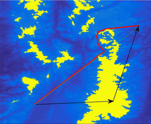
Figure 6. Route 2 analyzed in a contour map.
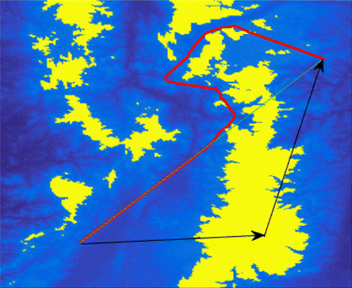
Table 8. Simulation results in terms of distance traveled
4.4. Simulation results
The results of the simulation of different profiles and flight segments in terms of operating costs are listed here. To provide a future perspective, the direct operating costs are presented with a 30-year forecasting horizon.
Tables and list the results of the operating costs of the test routes. Two test routes were established with three possible paths for each route. The three test paths consisted of a direct route without obstacles following the flight plan, an alternate route following the flight plan, and a route proposed by the optimization algorithm developed in this study. Alternate routes are an option when the direct route has obstacles that require a different route.
Table 9. Optimized route vs alternate route: route 1
Table 10. Optimized route vs alternate route: route 2
The simulated flight conditions were under adverse weather conditions, which in the case of the direct and alternate route according to the flight plan were completely obstructed by storms that would affect the safety of a flight. Under these conditions, the proposed route planner delivered optimized routes based on a safe flight route without obstacles.
The results showed that in route 1, when the density of the obstruction is high and the obstruction area is low, as presented in Figure , the route proposed by the planner is 11 km shorter than the alternate route based on a flight plan. The direct operating cost is 1.16% and the total operating cost is 0.14% lower in the route obtained with the route planner with respect to the alternate route (refer to Table ).
The route 2 has particularities in its result, that is, the alternate route presents better results in operating costs (see Table ). But the alternate route has total obstruction with high density covering a very large area as can be observed in Figure . The analysis of these results will allow the pilot and the flight controller to make the decision of whether to risk the aircraft and passengers when selecting a route with high obstruction due to adverse weather conditions or to take an optimized route that presents no risk, but increases the operating costs.
5. Conclusion
This study evaluated the behavior of an online route planning system. This system provides flight crews and traffic controllers on the ground with possible alternate routes that were not considered in the pre-planning of the route at the time of delivering the flight plan. Within the recommendations and suggestions made by International Civil Aviation Organization (ICAO) to maintain air safety, note that procedures were established for circumstances that require drastic changes to the primary flight route and the alternate route. Because these drastic changes are not considered in the flight plan, proposing and providing tools to help reduce operating costs by route optimization, when these tools are not considered in the original flight plan, will reduce pollutant emissions to the atmosphere while reducing fuel consumption and the direct costs of operation and maintenance.
This study proposes a technique that is intended to help route planning in real time and provide options in the design of a new route that maintains the shortest travel distance compared with the direct route.
The results have demonstrated the potential for the evaluation of routes that were not previously considered, and their cost relative to a reference route can be evaluated. It demonstrates in one of the scenarios that the proposed route planner reduces the engine direct operating cost in 1.16% with respect to the alternate route (i.e. according to the flight plan) when the direct route needs to be changed due to weather or other circumstances.
For future work the algorithm proposed will be used to optimize the main segments of an aircraft flight profile (i.e. take-off, climb-out, cruise, decent and landing).
| Subscripts | ||
| c | = | Combustor |
| cr | = | Cruise condition |
| sls | = | Sea Level Static |
| Nomenclature | ||
| BPR | = | ByPass Ratio |
| CO | = | Carbon Monoxide |
| CO2 | = | Carbon Dioxide |
| EI | = | Emission Index |
| FAR | = | Federal Aviation Regulations |
| FN | = | Net thrust |
| FPR | = | Fan Pressure Ratio |
| GTF | = | CVC Constant volumeCombustor Geared Turbofan |
| H2O | = | Water Vapor |
| LTO | = | Landing and Take-Off |
| MTOW | = | Maximum Take-Off Weight |
| NASA | = | National Aeronautics and Space Administration |
| NOx | = | Nitrogen Oxides |
| OPR | = | Overall Pressure Ratio |
| PD | = | Public Domain |
| PMDF | = | Preliminary Multidisciplinary Design Framework |
| PSO | = | Particle Swarm Optimization |
| RF | = | Radiative Forcing |
| SFC | = | Specific Fuel Consumption |
| TAS | = | True Air Speed |
| TET | = | Turbine Entry Temperature |
| UHC | = | Unburned HydroCarbons |
| VFR | = | Visual Flight Rules |
| ZFW | = | Zero Fuel Weight |
Funding
This work was supported by the Universidad Cooperativa de Colombia [grant number 1510].
Acknowledgments
This study was supported by the Universidad Cooperativa de Colombia under the “Evaluación Ambiental y Tecno-económica de Sistemas de Micro cogeneración a partir de Biomasa” research project sponsored by the University. It was also supported by Instituto Tecnológico Metropolitano in the framework of the master’s thesis entitled “Metodología para el Planeamiento Automático de Rutas en Vehículos Aéreos no Tripulados Usando Algoritmos Bio-inspirados Sobre Sistemas Embebidos”. We recognize the “Catalysis for Sustainable Energy Production and Environmental Protection” Group of Institute of Physical Chemistry of the Polish Academy of Sciences for their assistance in the creation of the environmental impact models and their contribution to the discussion of the results.
Additional information
Notes on contributors
Ramón Fernando Colmenares-Quintero
Ramón Fernando Colmenares-Quintero is currently national head of research in engineering and Professor Dr at the Universidad Cooperativa de Colombia (UCC) with research focus on energy generation, simulation and modelling in the energy sector, aviation and techno-economic and environmental risk assessments and multi-objetive optimization for biomass-based cogeneration and innovative propulsion systems.
Germán David Góez-Sánchez
Germán David Góez-Sánchez is assistant professor at the Department of Electronics and Telecommunications Engineering of the Instituto Tecnológico Metropolitano (ITM). His main research interests encompass bioinformatics, optimization, robotics and embedded systems. He is a researcher of the Automation, Electronics and Computer Science Group whose work consists of bioinformatics, optimization, pattern recognition, machine learning and image recognition.
Juan Carlos Colmenares-Quintero
Prof. Dr Juan Carlos Colmenares-Quintero is the leader of the research group “Catalysis for sustainable energy production and environmental protection, CatSEE” from the Institute of Physical Chemistry of the Polish Academy of Sciences in Poland. His interests range from materials science, nanotechnology and heterogeneous catalysis to biomass/CO2 valorisation, solar chemicals, sonication, photocatalysis and water/air purification.
Related Research Data
References
- Aeronáutica Civil Colombiana . (2015). Autoridad Aeronáutica . Retrieved from http://www.aerocivil.gov.co/AAeronautica/Paginas/Inicio.aspx
- Anon . (2014). Reglas de vuelo visual , 4–5. AIP COLOMBIA ENR.
- Clerc, M. (2005). Particle swarm optimization . Hermes Science/Lavoisier.
- Clerc, M. (2012). Standard particle swarm optimisation (Chapter 1, 1–19). Innovations and Developments of Swarm Intelligence Applications. Retrieved from https://pdfs.semanticscholar.org/c26f/d373a085b72b9a83724ef44b0d3780f0b93e.pdf
- Colmenares, R. F. , Brink, R. , Ogaji, S. , Pilidis, P. , Singh, R. , Colmenares, J. C. , & García, A. (2009). Application 2009 power for land, sea and air conference, Orlando, USA, June 8–12 2009, GT2009-59096.
- Colmenares, R. F. , Coutinho, A. , Ogaji, S. , Pilidis, P. , Singh, R. , Pincay, N. A. , & Hernandez, J. C. (2009). Feasibility study of a conventional turbofan with a constant volumecombustor. ASME Turbo Expo 2009 Power for Land, Air Conference, Orlando, USA, June 8–12 2009, GT2009-59097.
- Colmenares Quintero, R. F. (2009). Techno-economic and environmental risk assessment of innovative propulsion systems for short-range civil aircraft ( PhD Thesis). Cranfield University, Cranfield, UK.
- Colmenares Quintero, R. F. , Brink, R. , Ogaji, S. , Pilidis, P. , Colmenares Quintero, J. C. , & Quintero, A. G. (2010). Application of the geared turbofan with constant volumecombustor on short-range aircraft: A feasibility study. Journal of Engineering for Gas Turbines and Power , 132 (6), 061702. doi:10.1115/1.4000135
- Góez, G. D. (2016). Planeamiento de Rutas en Vehículos Aéreos No Tripulados usando Algoritmos Bio-inspirados sobre Sistemas (MSc Thesis). Instituto Tecnologico Metropolitano, Medellin, Colombia.
- ICAO . (2009). Manual de diseño de procedimientos de performance de navegación requerida con autorización obligatoria (RNP AR) ( O. de A. C. Internacional , Ed.). (2009th ed.).
- International Civil Aviation Organization . (2006). Convention on International Civil Aviation . Retrieved from http://www.icao.int/publications/documents/7300_9ed.pdf
- Jadoun, V. K. , Gupta, N. , Niazi, K. R. , & Swarnkar, A. (2014). Nonconvex economic dispatch using particle swarm optimization with time varying operators. In The Advances in Electrical Engineering (Vol. 2014, 13 pages). Hindawi Publishing Corporation. Article ID 301615. doi:10.1155/2014/301615
- Jadoun, V. K. , Gupta, N. , Niazi, K. R. , Swarnkar, A. , & Bansal, R. C. (2015a, May). Short-term non-convex economic hydrothermal scheduling using dynamically controlled particle swarm optimization. 3rd Southern African Solar Energy Conference, South Africa, 11–13 May, 2015 , 199–204. Retrieved from http://doi.org/http://hdl.handle.net/2263/49490
- Jadoun, V. K. , Gupta, N. , Niazi, K. R. , Swarnkar, A. , & Bansal, R. C. (2015b). Improved particle swarm optimization for multi-area economic dispatch with reserve sharing scheme. IFAC-PapersOnLine , 48 (30), 161–166. doi:10.1016/j.ifacol.2015.12.371
- Jadoun, V. K. , Gupta, N. , Niazi, K. R. , Swarnkar, A. , & Bansal, R. C. (2015c). Multi-area economic dispatch using improved particle swarm optimization. Energy Procedia , 75 , 1087–1092. doi:10.1016/j.egypro.2015.07.493
- Jardin, M. (2003, June). Real-time conflict-free trajectory optimization. 5th USA/Europe ATM 2003 R&D Seminar . Retrieved from http://www.atmseminar.org/seminarContent/seminar5/presentations/pr_027_TFO.pdf
- Jensen, L. , Hansman, J. R. , Venuti, J. , & Reynolds, T. (2014). Commercial airline altitude optimization strategies for reduced cruise fuel consumption. 14th AIAA Aviation Technology, Integration, and Operations Conference (P. 3006) . http://doi.org/10.2514
- Lee, K.-B. , & Kim, J.-H. (2013). Multiobjective particle swarm optimization with preference-based sort and its application to path following footstep optimization for humanoid robots. IEEE Transactions on Evolutionary Computation , 17 (6), 755–766. doi:10.1109/TEVC.2013.2240688
- Leonard, B. J. , & Engelbrecht, A. P. (2013). On the optimality of particle swarm parameters in dynamic. Environments , 1564–1569. doi:10.1109/CEC.2013.6557748
- Mason, K. , & Miyoshi, C. (2009). Airline business models and their respective carbon footprint? Final Report Main Thematic Area? Economics .
- Meng, H. , & Xin, G. (2010). UAV route planning based on the genetic simulated annealing algorithm. IEEE International Conference on Mechatronics and Automation , 2010 , 788–793. doi:10.1109/ICMA.2010.5589035
- Munoz, D. M. , Llanos, C. H. , Coelho, L. D. S. , & Ayala-Rincon, M. (2010). Hardware particle swarm optimization based on the attractive-repulsive scheme for embedded applications. In 2010 International Conference on Reconfigurable Computing and FPGAs , 55–60. doi:10.1109/ReConFig.2010.73
- Murrieta-Mendoza, A. , Botez, R. M. , & Félix Patrón, R. S. (2015, September). Flight altitude optimization using genetic algorithms considering climb and descent costs in cruise with flight plan information (SAE Technical Papers). doi:10.4271/2015-01-254
- Peng, Z. , & Li, B. (2012). Online route planning for UAV based on model predictive control and particle swarm optimization algorithm, (60925011), 397–401. doi:10.1109/WCICA.2012.6357907
- Roberge, V. , Tarbouchi, M. , & Labonté, G. (2013). Comparison of parallel genetic algorithm and particle swarm optimization for real-time UAV path planning. IEEE Transactions on Industrial Informatics , 9 (1), 132–141.
- Tewolde, G. S. , Hanna, D. M. , & Haskell, R. E. (2009). Accelerating the performance of particle swarm optimization for embedded applications. In 2009 IEEE Congress on Evolutionary Computation , 2294–2300. doi:10.1109/CEC.2009.4983226
- Wang, Y. , Yin, H. , Zhang, S. , & Yu, X. (2014). Multi-objective optimization of aircraft design for emission and cost reductions. Chinese Journal of Aeronautics , 27 (1), 52–58. doi:10.1016/j.cja.2013.12.008.
- Xu, J. , Andrew Ning, S. , Bower, G. , & Kroo, I. (2014). Aircraft route optimization for formation flight. Journal of Aircraft , 51 (2), 490–501. doi:10.2514/1.C032154
- Xue, Q. , Cheng, P. , & Cheng, N. (2014). Offline path planning and online replanning of UAVs in complex terrain, 2287–2292. doi:10.1109/CGNCC.2014.7007525
- Yang, X. , & Deb, S. (2014). Cuckoo search: Recent advances and applications. Neural Computing and Applications , 24 , 169–174. doi:10.1109/CGNCC.2014.7007525
- Yang, X. , & Press, L. (2010). Nature-inspired metaheuristic algorithms (2nd ed.). Luniver Press Frome, BA11 6TT, United Kingdom. Retrieved from www.luniver.com