
 ?Mathematical formulae have been encoded as MathML and are displayed in this HTML version using MathJax in order to improve their display. Uncheck the box to turn MathJax off. This feature requires Javascript. Click on a formula to zoom.
Abstract
In Malaysia, containerized freight transport has been growing and is expected to continue in that trend in the future. This research aims to provide a model for the assessment of containerized freight movement through intermodal transport network of Peninsular Malaysia. To design such a model, ArcMap software was used to build the transport network and MATLAB software was used to design the user-interface and to develop shortest path algorithm for analyzing the transport network. The focus of the analysis was to identify the optimum route and mode(s) of transport from origin to destination for different objective functions such as distance, time, emission and cost. Besides, the study explored tradeoffs associated with least-distance, least-time, least-emission and least-cost routes. To demonstrate the applicability of the proposed model, two case studies were analyzed. The presented methodology and procedures are applicable not only on any origin-destination pair in the transport network of Malaysia, but also on any other intermodal transport networks.
Public Interest Statement
In Malaysia, containerized freight transport has been growing and it is expected to continue in that trend in the future. The growth of Malaysia’s annual container volumewas projected to be more than 28% from 2015 to 2020. Therefore, the freight transport system needs to consider the growing impacts it has on the congestion, time of delivery, cost and environmental issues. To address such issues, there is a need to develop a model to analyze intermodal transport network under different decision criteria and scenarios. In this study, ArcMap and MATLAB software were implemented to design a model to apply intermodal transport network of Peninsular Malaysia. This is targeted at proposing the optimum route and mode(s) of transport of containers from origin to destination point in the network. The developed model could be applied in any other region of similar characteristics.
1. Introduction
The last decade has shown a significant increase in the number of freight containers transportation in Malaysia and prospects for the future shows steadily increase. Containers at ports can be local or transshipment containers. Local containers are referred to as containers which is moving in and out of the country from or to ports, and transshipment containers are those containers in transit to another country. The growth of Malaysia’s annual container volumewas reported by Ministry of International Trade and Industries (Ministry of International Trade & Industries Malaysia, Citation2005). It is expected that the growth of annual containers volumeto be more than 28% during the period 2015 to 2020. According to World Shipping Council (Citation2017), in the year 2014, Malaysia was ranked 13th and 12th in the world respectively for import and export of containerized cargoes.
As a result of increasing volumeof local containers, inefficient use of transport modes or over dependent on one mode of transport can lead to major problems in term of environmental issue. In Malaysia, about 98 percent of major local containers are transported by road and others by rail (Chen, Jeevan, & Cahoon, Citation2016). Over utilization of trucks for movement of containers might increase congestion on the roads, which consequently increase transport time and fuel consumption. Excess fuel consumption will not only lead to increase in the cost of freight transport, but also increase emission and air pollution on roads and its surrounding areas.
Sustainable freight transportation necessitates the movement of containers in more cost-efficient and environmental-friendly ways. Thus, it is imperative to analyze intermodal transport networks for movement of containers and identification of optimum route based on a set of criteria such as distance, time, cost, and emission. Previous research has shown that time-based route selection is very important for products with short expiry date while least-cost route can ultimately affect final price of goods. The environmental impacts of freight movement are becoming noticeable than the past (Ang-Olson & Cowart, Citation2002; Horvath, Citation2006; Hricko, Citation2006; Kreutzberger, Macharis, Vereecken, & Woxenius, Citation2003; Léonardi & Baumgartner, Citation2004). Hence, route selection based on environmental criteria could identify environmentally sustainable ways for freight movement which could significantly reduce pollution and its effect on air quality. According to ICF Consulting (Citation2005), most freight transportation modes such as trucks, trains and ships are powered by diesel engines. These freight transport vehicles are significant emission sources releasing some local and regional pollutants such as nitrogen oxides, sulfur dioxide, particulate matter as well as greenhouse gases (GHG) like carbon dioxide (CO2) (Ang-Olson & Cowart, Citation2002; Friedrich & Bickel, Citation2001; Horvath, Citation2006; Kroon, Smit, & van Ham, Citation1991). CO2 being the major greenhouse gas contributor from burning fossil fuels, can exacerbate the problem of climate change. Research by European Commission [ECO] (Citation2012) indicates that the emission of CO2 is the predominant GHG as far as global warming is concerned.
In spite of the extensive literature on the container transportation studies, yet detailed and specific research about the route choice analysis on intermodal freight transportation in Malaysia has not been carried out. This research provides an approach combining ArcGIS and MATLAB modeling for container transport analysis to overcome shipments challenges through intermodal networks in terms of route/modal preferences across various decision criteria. ArcMap software was used to construct the intermodal transport network, and characterize its components by coordinate attributes. In addition, MATLAB software was adopted to develop Dijkstra’s algorithm to analyze transport network and to design the user-interface. According to Sniedovich (Citation2006), Dijkstra’s algorithm is very well-known among shortest path algorithms since it generates (exact) optimal solutions to a large class of shortest path problems. Nowadays, the usage of MATLAB software is increasing extensively specially in the application of Dijkstra’s shortest path algorithm (Gu & Shang, Citation2012). To demonstrate the use and approach of the proposed model, two case studies in transport network of Peninsular Malaysia were analyzed in this study.
2. Prior studies
The Geographic Information System (GIS) software have been used as a modeling tool in transportation-related studies since late 80s. One of the main advantages of GIS is its capability in creation of variety of network models by using arcs and nodes. The capability of visualizing of transportation networks differentiate GIS models from the mathematical models. The prior intermodal models which utilize GIS to construct an intermodal transport network were developed to model freight flow include (Arnold, Peeters, & Thomas, Citation2004; Boile, Citation2000; Janic, Citation2007; Luo and Grigalunas, Citation2002; Southworth & Peterson, Citation2000; Southworth, Xiong, & Middendorf, Citation1997; Standifer & Walton, Citation2000).
Southworth et al. (Citation1997) discussed the method of construction of an intermodal network by integrating highway, rail, marine, and air networks in GIS environment to study freight transport. They used both real and notional connectors for the construction of intermodal network. Real connectors were either local access roads or rail spurs that connect a modal segment to an intermodal terminal. The notional connector is an artificial connector linking one mode to another, but the links are only for representation and not physical links. According to these authors, inability to connect separate modes into a cohesive routable network was the main problem. Southworth and Peterson (Citation2000) described the development of a large and detailed multimodal network. The paper focused on the routing of the large number of intermodal freight movements. Routings involve different combinations of truck, rail and water transportation. Selection of appropriate intermodal routes requires procedures for linking freight origins and destinations to the transportation network, modeling intermodal terminal transfers, and generating multimodal impedance functions to reflect the relative costs of alternative routes. Boile (Citation2000) presented a framework to conduct shortest-path analysis of intermodal freight movement. The method used TransCAD, the GIS environment, to generate analysis necessary files for the network, which includes information on network, service and demand characteristics, capacity of network facilities and cost components associated with the transportation services such as tolls, parking fees and transit fares. The mathematical model used was developed outside GIS by using linear programming software such as General Algebraic Modeling System (GAMS). The results provided information on traffic volumes and flow patterns on the network, and associated transport times and costs. The author also evaluated the impacts of traffic on the performance of transportation systems.
Standifer and Walton (Citation2000) created an intermodal network focused on the State of Texas. The authors created a cohesive intermodal network in GIS integrating rail, ocean, inland waterway, and truck modes with transfer facilities. The authors were one of the first to utilize the Network Analyst extension within ArcView GIS to create their intermodal network. They also adopted the concept of real and notional connectors as highlighted by Southworth et al. (Citation1997). The model was utilized to find least time and least cost routes for freight within the State of Texas. Their model could perform a variety of analyzes as a decision support system for shippers, planning agencies and researchers.
Winebrake et al. (Citation2008) presented a Geospatial Intermodal Freight Transportation (GIFT) model developed through GIS platform. It finds the route from an origin to destination in an intermodal transportation network by considering the objective functions such as cost, time and emission. The GIFT model integrates highway, rail, and shipping networks through ports, rail yards, and other transfer facilities to create an intermodal freight transportation network and characterizes the network using temporal, economic, and environmental attributes. The GIFT model was developed in ArcGIS 9.3 and uses the ArcGIS Network Analyst tool to conduct its optimal route solving. What differentiated GIFT model from other GIS-based intermodal networks is the inclusion of economic, time, energy and environmental attributes, which allows for the analysis of optimal freight routing across a host of objective functions. Tradeoffs associated with different goods movement choices can be explored. Comer et al. (Citation2010) explored environmental, economic and time-of-delivery tradeoffs associated with the application of marine vessels as substitutes for heavy-duty trucks operating in the Great Lakes region of North America by using the GIFT network optimization model.
Athakorn, Tuammee, and Tuominen (Citation2014) developed a six-phase framework for route selection in multimodal transportation reduce cost, lead time, risk and CO2 emission in multimodal transportation systems. The stages of the framework were data collection of each route, selection of origin and destination, calculate time and cost of each route by using a multimodal transport cost-model, calculation of the CO2 emissions based upon the 2006 guidelines of Intergovernmental Panel on Climate Change. It also involves evaluation of multimodal transportation risk through integration of quantitative risk assessment, Analytic Hierarchy Process (AHP) and data envelopment analysis methodology, prioritizing criteria by using the AHP, and finally, optimal route calculation by using the zero-one goal programming. Their approach has been tested a realistic multimodal transportation service, originating from Bangkok in Thailand to a destination at Da Nang port in Vietnam. Their result showed that the approach provided the guidance in choosing the lowest cost route in accordance with other criteria, and to minimize the CO2 emission effectively.
3. Methodology
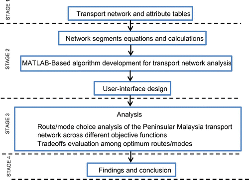
The approach of the presented study comprises 4 stages, which include construction of intermodal transport network, development of the Dijkstra’s algorithm and design the user-interface, route/modal choice analysis and tradeoff evaluation of the results, and finally, findings and conclusion. The flowchart of the approach is depicted in Figure .
Figure 1. The flow chart of the study stages.
3.1. Intermodal transport network construction
The components of transport network can be categorized into line and point features. Line features include single-mode transport networks and auxiliary links, and point features consist of ports and modal change points. All components of the transport network include attribute table. The attribute table of point features include latitude and longitude, and that of line features consist of the length of each line as well as coordinate information of its start and end points. The coordinate system of all line and point features was projected as UTM WGS 1984 Zone 47 N.
3.1.1. Line features
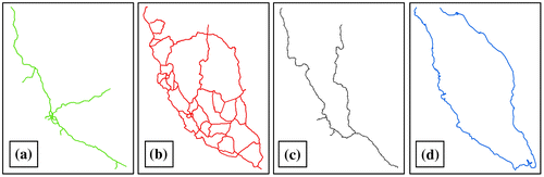
The single-mode transport networks involve road, railway and waterway networks. The road transport network includes highway and federal road feature classes. In this study, the coast-line of Peninsular Malaysia was considered as waterway network. Each single-mode network was saved in one shapefile in ArcMap. The highway, federal road, railway and waterway networks include 61, 121, 9 and 10 segments, respectively. The coordinate of start and end point of each link were calculated by using “calculate geometry option”. The results were saved in their related attribute tables. Highway, federal road, railroad and waterway feature classes are illustrated in Figure (a–d).
Figure 2. Highway (a), federal road (b), railroad (c), and waterway (d).
3.1.2. Auxiliary (artificial) lines
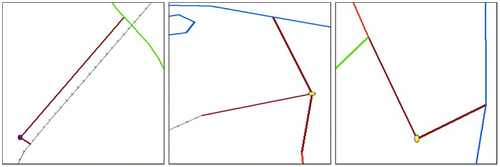
Network auxiliary transfer links are the artificial connections that are created to form a connection between the three modal networks. These are artificial connections because they are just used to connect the road, rail and water networks at ports and intermodal terminals. This connection is essential for completing the network model since it allows freight shipments to transfer from one mode to another. The examples of artificial lines in the transport network are shown in Figure .
Figure 3. Examples of artificial lines.
3.1.3. Point features
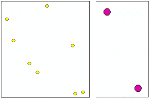
In this study, In this study, ports and intermodal terminals are represented as points or nodes. There are eight ports and two intermodal terminals. The ports include Klang port, Tanjung Pelepas port, Lumut Maritime terminal, Penang port, Kuantan port, port Dickson, Kota Bahru port, and Johor port, and intermodal terminals include Nilai Inland port and Ipoh Cargo terminal. Generally, based on the roles of nodes in container transport, they are categorized into origin, destination and transfer nodes. Origin nodes are starting point, and destination nodes are the final destinations for container shipments. Transfer nodes are points in which containers could be loaded into vehicle, unloaded from the vehicle, and transferred from one mode of transport to another.
Ports and intermodal terminals are point features which were saved in two different shapefiles. The coordinates of each point were saved in its attribute table. Ports and intermodal terminals are depicted in Figure .
Figure 4. Ports (left) and intermodal terminals (right).
3.2. Intermodal transport network model
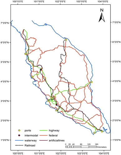
The resulting intermodal transport network model of Peninsular Malaysia consists of 178 nodes and 224 links as shown in Figure . It includes all single-mode transport networks, point features and auxiliary lines. In constructing the network, highway and federal-road are connected to one another at intersection points. Therefore, at such points, there is possibility to navigate from highway to federal-road and vice versa. While there is no connection between road modes and other networks (i.e., railroad and waterway) at their intersection points. In this transport network, any node can be selected as origin or destination point, and mode-to-mode transfer can be occurred at ports and intermodal terminal nodes. All links in the transport network were considered as bidirectional links.
Figure 5. Intermodal transport network of Peninsular Malaysia.
3.3. Modelling the decision criteria
The purpose of decision criteria modeling is to determine the method and equations used to calculate each segment of the transport network based on objective functions such as distance, time, CO2 emission and cost. The MATLAB software was used for coding the decision criteria equations. In calculating the distance, length of each link is acquired by using “length” option in calculate geometry window of attribute table of each single-mode transport network. The total distance of the least-distance route between any pair of points is equal to the sum of the length of all links included in the route. Transport time for each link of the transport network was calculated based on the length of the links and average speed of the transport vehicle used to transport containers on that particular link. The total transport time is the sum of transport time through all involved links in the optimum route plus the transfer time for modal changing at ports or intermodal points where applicable. The accumulative transport time was calculated using Equation (1).(1)
(1)
where Tt = total transport time (h), Td = transport distance (km), Sa = average speed (km/h) and Tmc = time of modal change (h).
The amount of emission (in kg) on each segment of the network is a function of emission factor, and operations related factors such as distance of the path, number of containers and weight of loaded container. The total amount of CO2 is the total sum of emission generated in all links involved in the optimum route plus the transfer emission for modal changing at ports or intermodal points where applicable. The CO2 emission can be expressed by Equation (2). In this study, 20-foot dry container was chosen. Weight specification for the selected container includes cargo capacity of 2,1640 kg and tare weight of 2,360 kg. Hence, the total weight of the loaded container is approximately 24tons. An emission factor is a representative value that attempts to relate the quantity of a pollutants released to the atmosphere with an activity associated with the release of that pollutant. The emission factor was obtained from the (Greenhouse Gas Protocol, Citation2017) (Available at: http://www.ghgprotocol.org/) to estimate emission for different modes of transport as presented in Table .(2)
(2)
Table 1. Associated emission factor for different transport modes
where E, Ef, Cw, Nc, Td, and Emc are total emission (kg), emission factor (kg/ton-km), container weight (ton), the number of containers, transport distance (km), and emission for modal change (kg).
In this study, the purpose of total cost is the transportation cost in intermodal networks which include internal costs and transfer cost. Therefore, the calculations for total cost are broken down into transport cost of all network segments involved in the optimum route and transfer cost at ports or intermodal points where applicable. The influential parameters of transport cost function composed of fuel price, fuel consumption, driver wage, maintenance, toll cost on highway, cost at modal change points, number of containers, capacity of transport vehicle, involved distance and time. Transport cost was calculated using Equation (Equation3(3)
(3) ).
(3)
(3)
where Tc, Fp, Fc, Td, Tdh, and Cmc are transport cost (RM), fuel price (RM/liter), and fuel consumption (liter/km), transport distance (km), transport distance on highway (km), and cost for modal change (RM), respectively. While Wa, Tt, Ma, Nc, and Cv represent wage (RM/h), transport time (h), maintenance (RM/km), number of containers, and capacity of the vehicle (number of TEUs) respectively. In this study, the average toll cost per truck per kilometer was considered as RM 0.25.
3.4. Modal change points calculation
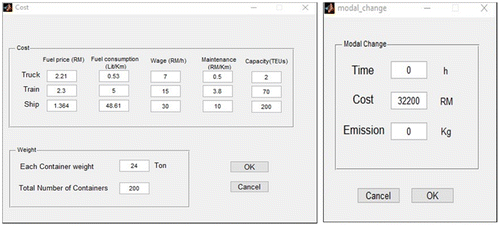
Changing mode of transport at intermodal terminals or ports include time, emission and cost per container. These parameters should be considered in calculating total time, emission and transport cost when identifying an optimum route. Unfortunately, there is lack of information in the literature regarding time of transfer and emitted CO2 per container at Malaysian ports and intermodal terminals. Therefore, value for transfer time was assumed as 10 min/container. According to Starcrest Consulting Group (Citation2005), CO2 emissions at intermodal terminals for ship to rail, ship to truck and truck to rail are considered as 741, 749 and 567 gr/TEU respectively. In this study, the average amount of CO2 among transport vehicles for modal changing was considered as 686 gr/TEU. According to container terminal handling tariff report of Westport Malaysia (port Klang) 2016 (Available at: www.westportsmalaysia.com.my), cost for transshipment of containers are given as RM 161 for 20-foot containers. In this study, it was assumed that container handling equipment at all ports and intermodal are the same. Hence, the transfer time, cost, and emission in all intermodal terminals and ports are same.
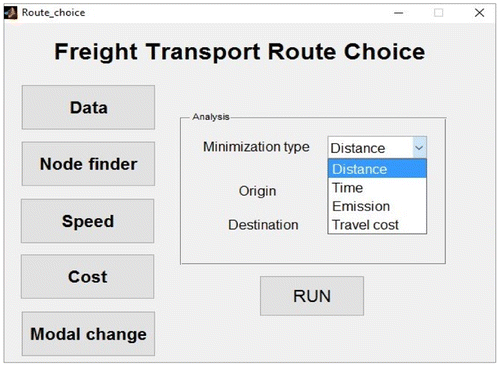
3.5. User-interface design
The user-interface for intermodal freight transport network was designed in MATLAB environment. It comprises main window and sub-windows which is depicted in Figure . The main window enables the user to select any of four objective functions from the drop-down menu, input origin and destination nodes by typing node number in the designated origin and destination area. The sub-windows enable the user to input speed of vehicles, influential parameters of cost and modal change, and node finder. The node finder is designed in order to find out the node number of origin and destination points. For this purpose, it is necessary to input the coordinate of the nodes. Using the information button in ArcMap and clicking on each point or line feature, provide the user with coordinates of any specific node or link. In the cost sub-window, the user inputs information such as fuel price, fuel consumption, wage of the driver, maintenance cost and the vehicle capacity, for truck, train and ship. Also, information regarding the weight of each fully-loaded container and total number of containers can be input in the cost sub-window. The last sub-window of the user-interface is the modal change window. This window allowing the user to input information such as necessary transfer time between modes per container, cost incurred by changing mode per container and amount of CO2 emitted per container at modal change points.
Figure 6. Main window of the user-interface.
4. Approach of the algorithm
The development of the model for route proposing in intermodal transport networks includes a nine-phase approach. The first phase is to load highway, federalroad, railway, waterway and auxiliary line shapefiles. The second phase is to reading X and Y coordinate of all point features as well as coordinate of start-point and end-point of all segments of each mode of transport. In the third phase, the length of all segments are calculated by using Pythagoras theorem. The fourth phase is to save the result of steps 2 and 3 in 1 × 5 matrix (e.g. [X1 Y1 X2 Y2 L] where X1 and Y1 are coordinate of start-point of a segment, X2 and Y2 are coordinate of end-point of a segment, and L is the length of a segment). In the fifth phase, time, emission, and cost of all network segments are calculated by using Equations (2)–(4) respectively. The sixth phase is to select the type of minimization, origin and destination nodes through user-interface. The seventh phase is to read coordinates of all segments of each mode of transport and identifying the mode of transport between nodes and save them in different matrices for each mode of transport. The eighth phase is to propose optimum route from origin to destination based on minimization type through Dijkstra’s algorithm and to save the route. The final phase is to plot the result.
5. Result for case 1
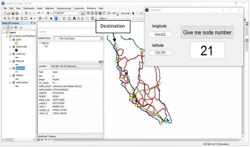
In case 1, the origin and destination points were Johor port and the top-north-point on the transport network respectively. The top-north-point was considered because it appeared to be farthest from origin point. Before conducting analysis, it was necessary to determine the node number of origin and destination points. For this purpose, the “identify” option in ArcMap software and “node finder” option in main the window of user-interface were used. Coordinates (longitude and latitude) of the origin and destination points can be obtained by using either “identify” option or from the attribute table of each feature type of the network in ArcMap. These information were input into the “node finder” sub-window of user-interface to acquire related node numbers. Node number of origin and destination points were shown in Figures and .
Figure 7. Node number of the origin point.
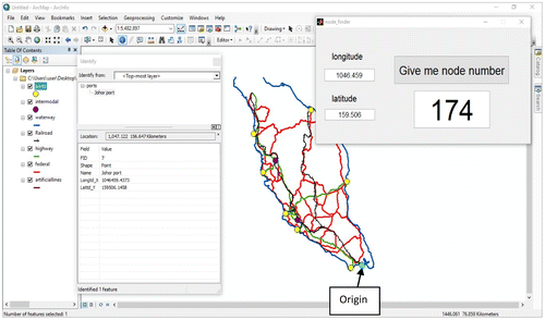
Figure 8. Node number of the destination point.
5.1. Transport distance
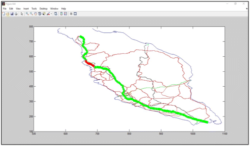
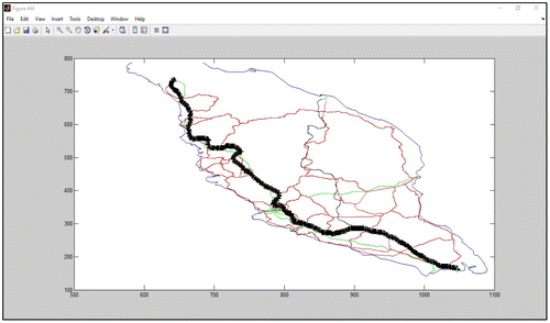
In identifying the best route based on distance, the only effective parameter is the length of the links in the network. To run the analysis, distance option from the “Minimization Type” dropdown was selected, and node number of origin and destination points were typed in the main window of user-interface. The goal in least-distance analysis was to determine an optimum route from the origin to destination point based on minimum distance. The results of transport distance analysis are depicted in Figures and . The results indicate the mode of transport for least-distance route was truck and the distance was 839.96 km. Most part of the route was through highway and very short part of it was through federal road.
Figure 9. Network representation of distance analysis.
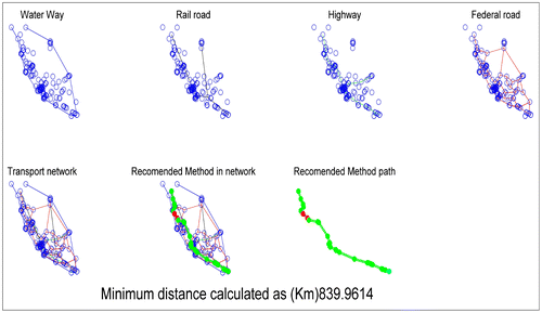
Figure 10. Graphical representation of distance analysis.
5.2. Transport time
Parameters influencing the time of transport are distance, average speed and transfer time at intermodal points or ports. Since modal transfer time was assumed as 10 min per container, and the total number of containers assumed as two-hundred. Then total modal transfer time was estimated as 33.3 h. Speed of each transport mode was assumed to be constant in all network segments of single mode transport networks. In this study, the average speed on road segments for highway, federal road, railroad and waterway were assumed as 50 and 40, 36, and 25 km/h respectively.
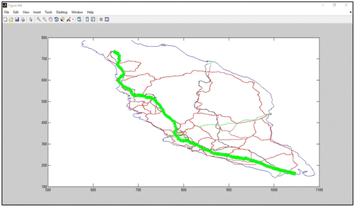
The least-time analysis was to identify an optimum path and associated mode(s) of transport in fastest possible time for movement of containers from the origin to destination point. The results of the least-time analysis are illustrated in Figures and . The result of least-time analysis clearly indicates that using trucks for movement of containers had the minimum time among transport vehicles and their combination. The total time for the least-time path was estimate to be 50.1 h. The least-time path included loading containers into truck at start point, but not unloading from trucks at destination point since the destination point was not intermodal terminal or port.
Figure 11. Network representation of time analysis.
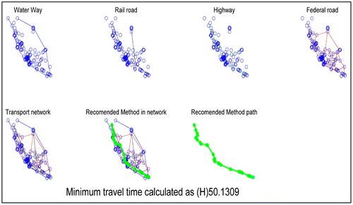
Figure 12. Graphical representation of time analysis.
5.3. Transport emission
Parameters influence the CO2 emission were emission factor, number of containers, weight of each container, distance, and emission generated at intermodal points or ports for modal changing. Since modal change emission was assumed as 686 grams per container at intermodal points and ports, and the total number of containers assumed as two-hundred, then, total emitted CO2 was estimated as 137.2 kg at modal changing points.
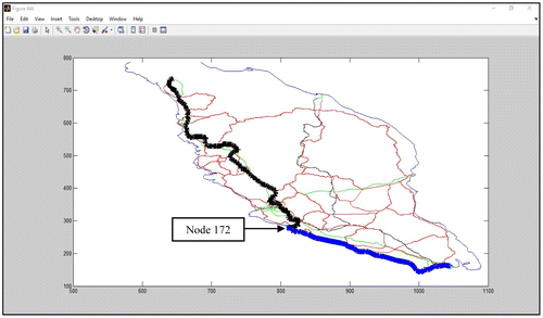
The least-emission analysis was to identify an optimum route and mode(s) of transport which emitted minimum amount of CO2 for movement of containers. The results in Figures and obviously indicated that the intermodal transport of containers by using ship and train had least amount of emission. The optimum path consisted of waterway mode from the origin to node number 172 (which is port Dickson), modal change at node number 172 from ship to train, then from node 172 to node 19 through artificial line. Finally, transport the rest of the route to the ultimate-destination point through railway mode. The total amount of emitted CO2 was calculated as 118052.6 kg (590.26 kg per container).
Figure 13. Network representation of emission analysis.
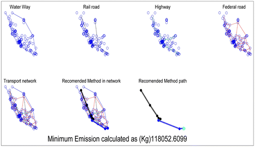
Figure 14 Graphical representation of emission analysis.
5.4. Transport cost
Influential parameters on transport cost consisted of fuel price, fuel consumption, driver wage, and maintenance cost of transport vehicle and capacity of vehicles for truck, train and ship. For this analysis, capacity of truck, train and ship were assumed as 2, 70, and 200 TEUs respectively. Since mode-to-mode transfer cost was assumed as RM 161 per container at intermodal points and ports, then total cost at modal changing points for two-hundred containers was estimated as RM 32200. This value was input on the “modal change” sub-window of the user-interface, and the value of other cost-related parameters such as number of containers, capacity of vehicles and weight of container were input in the “cost” sub-window of the user-interface as shown in Figure .
Figure 15. Values for influential parameters on transport cost.
The least-cost analysis was to identify an optimum route and associated mode(s) of transport, which included minimum cost for movement of containers from origin to destination point. Based on the results in Figures and , the total transport cost of loading containers into train at Johor port and direct railway to destination point was RM 73367.08 (i.e., RM 366.80 per container).
Figure 16. Network representation of transport cost analysis.
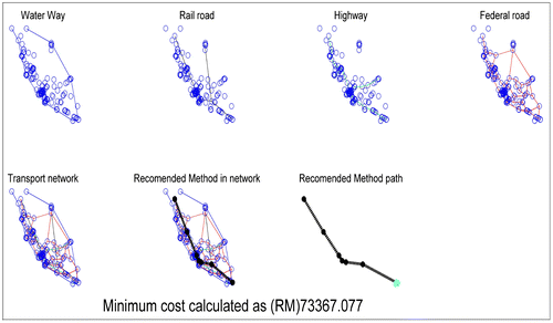
Figure 17. Graphical representation of transport cost analysis.
5.5. Tradeoffs evaluation
Tradeoffs evaluation was meant to compare the least-distance, least-time, least-emission and the least-cost route. The result of the tradeoffs evaluation is depicted in Figure . Based on the results, the least-distance and least-time routes for the movement of container was the road mode. However, when minimum cost was the objective, the choice was primarily train. The least-time route emitted highest CO2, and it was the costliest mode among other minimized-routes. The most environmental-friendly route was the combination of waterway and railway modes.
Figure 18. Route analysis result.
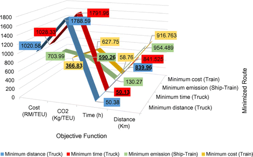
Comparing the least-time path with the least-emission showed considerable tradeoffs between them. The total cost of least-time route was less than half of the least-emission route, but instead the CO2 emission of the least-time route was about three times more than the least-emission path. Also, the emitted CO2 of the least-time route was about three times more than the least-cost path, while transport of containers through least-cost route lasted almost 8 h longer.
For least-cost and least-emission routes, although the emission of least-cost route was a bit higher than the least-emission route, the total cost of least-cost route was about half of least-emission cost. In addition, the total transport time of least-cost route was less than half of the time of least-emission route.
6. Result for case 2
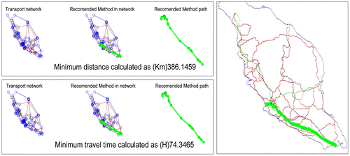
In case 2, the origin point selected similar to case 1, but its destination point was main port of Malaysia, Port Klang (Node number 171), as it is shown in Figure . The results of transport distance and time as shown in Figure , showed that the route and mode of transport are the same. The distance and the total transport time were estimated as 386.14 km and 74.3 h respectively. The total time of the least-time path included time of loading containers into truck at start point, transport time of all segments of the route and time of unloading them at destination point.
Figure 19. Destination node.
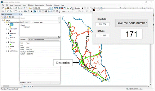
Figure 20. Network and graphical representation of transport distance and time analysis.
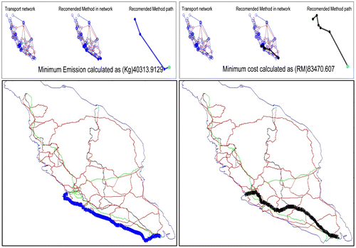
The results of emission and cost analysis are illustrated in Figure . The results of least-emission analysis in case 1 obviously indicates that ship emitted minimum amount of CO2 among other transport vehicles. Its total CO2 emission was obtained as 40,313.91 kg for transport of two-hundred containers (201.56 kg per container) from origin to destination node. The results of cost analysis clearly showed that the best mode of transport for moving containers in terms of minimum transport cost was railway mode (RM 417.30 per container).
Figure 21. Network and graphical representation of emission and cost analysis.
6.1. Tradeoffs evaluation
The result of the tradeoffs evaluation is shown in Figure . The results clearly indicate associated modal preferences for each of considered objective functions. The shortest route in terms of distance was related to road mode. Truck was the predominant mode of transport when time of transport has priority over other objectives. Waterway is the best mode in terms of least amount of CO2 emission while the cheapest mode of transport was the railroad.
Figure 22. Route analysis result.
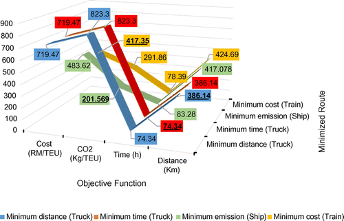
With attention to the point that the distance of least-time route was the minimum distance when compared with least-emission and least-cost routes, following tradeoffs can be deduced. Firstly, although the total transport time of the least-time route was about 9 h less than the least-emission route, but its emitted CO2 was four times more than the least-emission path. Secondly, comparing least-time route and least-cost route showed that total time of the least-time route was about 4 h less than least-cost route, but its total cost was about 70% higher than the least-cost route.
Comparison between least-cost (train) and least-emission (ship) routes showed that the CO2 emission of least-emission route was about two-third of the CO2 from the least-cost route, the total transport cost of each container in least-emission route was about 15% higher than the least-cost route.
7. Conclusions
The work presented a model to analyze the intermodal transport network of Peninsular Malaysia by finding the optimum route and mode(s) of transportation for specific objective functions such as distance, time, emission and cost. The model was demonstrated with two case studies. Since the results of analysis was completely dependent on origin and destination points, each case study was discussed separately, and it was difficult to generalize the results for any other origin-destination point in the network. Therefore, the main outcomes under the assumptions used in this analysis include: firstly, road mode was the fastest mode of transport in both case studies in terms of time-of-delivery. Secondly, for case 1, the most environmental-friendly method of transport was intermodal transport by combination of ship and train, while the least emission method of container transport was ship in case 2. Finally, the cheapest mode of transport for both case studies was the railroad. Besides route/modal choice analysis, the model was used to compare least-distance, least-time, least-emission and least-cost routes in order to evaluate their associated tradeoffs for both case studies. The results indicated that the only advantage of containers transport by truck, when compared with train and ship, was the matter of time of delivery. Over dependence on truck-based container transport might lead to production of high rate of CO2 emission. However, more involvement of trains in container transport would extremely reduce transport cost, CO2 emission that will consequently reduce the impacts on global warming and climate change.
Funding
The authors received no direct funding for this research.
| List of Abbreviations | ||
| TEU | = | Twenty-Foot Equivalent Unit |
| CO2 | = | Carbon Dioxide |
| GIS | = | Geographic Information System |
| GHG | = | Greenhouse Gas |
| ESRI | = | Environmental Systems Research Institute |
| WGS | = | World Geodetic Survey |
| UTM | = | Universal Transverse Mercator |
| List of Symbols | ||
| Tt | = | Transport Time |
| Td | = | Transport Distance |
| d | = | Distance |
| X i, Y i | = | Coordinate of Start-point of Segments |
| X j, Y j | = | Coordinate of End-point of Segments |
| Sa | = | Average Speed |
| Tmc | = | Modal-Change Time |
| Te | = | Transport Emission |
| Ef | = | Emission Factor |
| Cw | = | Container Weight |
| Nc | = | Number of Containers |
| Emc | = | Modal Change Emission |
| Tc | = | Transport Cost |
| Fp | = | Fuel Price |
| Fc | = | Fuel Consumption |
| Wa | = | Wage of the Driver |
| Ma | = | Maintenance Cost of the Transport Vehicle |
| Cv | = | Capacity of the Vehicle |
| Tdh | = | Transport Distance on Highway |
| Cmc | = | Modal Change Cost |
Additional information
Notes on contributors
Adel Gohari
Adel Gohari, Iraj Toloue, Khin Cho Myint, and Abdulkadir Sholagberu are PhD candidates at the Department of Civil and Environmental Engineering, Universiti Teknologi PETRONAS, Malaysia. Their research interest includes Geographical Information System (GIS), Intermodal freight transportation, Transport networks, Offshore platform, MATLAB as well as Global Positioning System. Abd Nasir Matori and Khamaruzaman Wan Yusof are Associate Professors at the same Department of the same institution, and their research interest are Geography, GIS, GPS, surveying, transportation studies as well as water resources engineering.
Related Research Data
References
- Ang-Olson, J. , & Cowart, B. (2002). Freight activity and air quality impacts in selected north American free trade agreement trade corridors. Transportation Research Record: Journal of the Transportation Research Board , 1815 , 86–95.10.3141/1815-11
- Arnold, P. , Peeters, D. , & Thomas, I. (2004). Modelling a rail/road intermodal transportation system. Transportation Research Part E: Logistics and Transportation Review , 40 (3), 255–270.10.1016/j.tre.2003.08.005
- Athakorn, K. , Tuammee, S. , & Tuominen, M. (2014). The development of a framework for route selection in multimodal transportation. The International Journal of Logistics Management , 25 , 581–610.
- Boile, M. P. (2000). Intermodal transportation network analysis-A GIS application. In Electrotechnical Conference, 2000, MELECON 2000 (Vol. 2 , pp. 660–663). IEEE.
- Chen, S. L. , Jeevan, J. , & Cahoon, S. (2016). Malaysian container seaport-hinterland connectivity: Status, challenges and strategies. The Asian Journal of Shipping and Logistics , 32 (3), 127–138.10.1016/j.ajsl.2016.09.001
- Comer, B. , Corbett, J. J. , Hawker, J. S. , Korfmacher, K. , Lee, E. E. , Prokop, C. , & Winebrake, J. J. (2010). Marine vessels as substitutes for heavy-duty trucks in great lakes freight transportation. Journal of the Air & Waste Management Association , 60 (7), 884–890.10.3155/1047-3289.60.7.884
- Consulting, I. C. F. (2005). Assessing the effects of freight movement on air quality at the national and regional level . Washington, DC: Office of Natural and Human Environment, US Federal Highway Administration.
- European Commission . (2012). Transport in Figures–Statistical Pocketbook . Luxembourg: Publications Office of the European Union.
- Friedrich, R. , & Bickel, P. (2001). Environmental external costs of transport . Berlin Heidelberg: Springer-Verlag.10.1007/978-3-662-04329-5
- Greenhouse gas protocol . (2017). Emission factors from cross sector tools . Retrieved June 2, 2017, from https://www.google.com/url?sa=t&rct=j&q=&esrc=s&source=web&cd=3&cad=rja&uact=8&ved=0ahUKEwi4zeSx2KnUAhWKQ48KHf2qBpoQFggtMAI&url=http%3A%2F%2Fwww.ghgprotocol.org%2Fsites%2Fdefault%2Ffiles%2Fghgp%2FEmission_Factors_from_Cross_SectorTools_March_2017.xlsx&usg=AFQjCNHVrWn2v-tPzys-ftNaILYtON0SNA/
- Gu, H. , & Shang, X. (2012, April). The research of Dijkstra shortest path algorithm based on Matlab. In Proceedings of the 2012 Second International Conference on Electric Information and Control Engineering, IEEE Computer Society (Vol. 2, pp. 1839–1841).
- Horvath, A. (2006). Environmental Assessment of Freight Transportation in the US. The International Journal of Life Cycle Assessment , 11 (4), 229–239.10.1065/lca2006.02.244
- Hricko, A. M. (2006). Ships, trucks, and trains: Effects of goods movement on environmental health. Environmental Health Perspectives , 114 (4), A204–A205.10.1289/ehp.114-a204
- Janic, M. (2007). Modelling the full costs of an intermodal and road freight transport network. Transportation Research Part D: Transport and Environment , 12 (1), 33–44.10.1016/j.trd.2006.10.004
- Kreutzberger, E. , Macharis, C. , Vereecken, L. , & Woxenius, J. (2003). Is intermodal freight transport more environmentally friendly than all-road freight transport? A review. In Nectar conference (Vol. 7, pp. 13–15).
- Kroon, M. , Smit, R. , & van Ham, J. (Eds.). (1991). Freight transport and the environment (Vol. 45). Amsterdam: Elsevier.
- Léonardi, J. , & Baumgartner, M. (2004). CO2 efficiency in road freight transportation: Status quo, measures and potential. Transportation Research Part D: Transport and Environment , 9 (6), 451–464.10.1016/j.trd.2004.08.004
- Luo, M. , & Grigalunas, T. A. (2003). A multimodal transportation simulation model for US coastal container ports. Presented at the Transportation Research Board Conference , Washington, DC.
- Ministry of International Trade and Industries Malaysia . (2005). Industrial Master Plan 3 . Retrieved June 2, 2017, from http://www.miti.gov.my/miti/resources/auto%20download%20images/557f968c24904.pdf/
- Sniedovich, M. (2006). Dijkstra’s algorithm revisited: The dynamic programming connexion. Control and cybernetics , 35 (3), 599.
- Southworth, F. , & Peterson, B. E. (2000). Intermodal and international freight network modeling. Transportation Research Part C: Emerging Technologies , 8 (1-6), 147–166.10.1016/S0968-090X(00)00004-8
- Southworth, F. , Xiong, D. , & Middendorf, D. (1997). Development of analytic intermodal freight networks for use within a GIS . In American Association of State Highway and Transportation Officials Conference Proceedings of the GIS-T 97 Symposium (pp. 201–218). United States.
- Standifer, G. C. , & Walton, C. M. (2000, June). (2000), “Development of a GIS model for intermodal freight” . Austin, TX: Southwest Regional University Transportation Center, The University of Texas.
- Starcrest Consulting Group, L. (2005). Port of Los Angeles Baseline Air Emission Inventory-2001 . Los Angeles, CA . Retrieved from https://www.portoflosangeles.org/DOC/REPORT_Final_BAEI.pdf
- Winebrake, J. J. , Corbett, J. J. , Falzarano, A. , Hawker, J. S. , Korfmacher, K. , Ketha, S. , & Zilora, S. (2008). Assessing energy, environmental, and economic tradeoffs in intermodal freight transportation. Journal of the Air & Waste Management Association , 58 (8), 1004–1013.10.3155/1047-3289.58.8.1004
- World Shipping Council . (2017). Trade Statistics . Retrieved June 12, 2017, from http://www.worldshipping.org/about-the-industry/global-trade/trade-statistics/