
 ?Mathematical formulae have been encoded as MathML and are displayed in this HTML version using MathJax in order to improve their display. Uncheck the box to turn MathJax off. This feature requires Javascript. Click on a formula to zoom.
Abstract
Rural electrification plans are a means of enhancing electricity services in a given area within a given period of time in accordance with pre-defined strategies. Establishment of prioritization concepts on the basis of objective criteria provides important indications for practical energy development. The choice of the most suitable electrification option with the given context is vital in energy planning. In developing countries, it’s difficult to electrify a sparsely populated community. Lack of scientific and methodological know-how in regards planning, site selection, distribution and density of population settlement, economic level, and distance from the national grid are main factors to lowest electrification rates in Ethiopia. Therefore, the objective of this study is to study the introduction of renewable energy systems as a possible alternative for rural electrification by using geospatial technologies in South Gondar Zone. Data like sunshine hour/irradiance, wind speed, slope, land use-land cover, protected areas, water bodies, forest, and towns are collected and analyzed with ArcGIS. These data are used to identify optimal electrification options for particular areas in four districts of the Zone. The weighting factors of these criteria are also determined using Analytic Hierarchy Process (AHP). This weighted and reclassified values are multiplied to produce the final map of electrification options. From the final results obtained, study area covers 5226.289 square kilometers from which 2897.742, 2836.134, and 802.003 square kilometer area is suitable for electrification using solar, wind, and grid extension, respectively. Solar energy is the optimal options for most of area in the Zone.
PUBLIC INTEREST STATEMENT
Electrifying rural community is difficult where distribution and density of population settlement is spaced like Ethiopia. Lack of proper planning in site selection, distribution, and density of population settlement, economic level, and distance from the national grid are challenging the process of electrification Ethiopia. Therefore, scientific planning is required to meet the targets of rural electrification. Thus, this study introduces renewable energy systems as a possible alternative for rural electrification by using geospatial technologies in South Gondar Zone . A Geographic information system (GIS)-based graphics management system is important for rural electricity planning. The integration of basic information and geographic information enables planning easy. These information are considered by developing a geospatial information system to obtain best possible electrification planning and strategies.
1. Introduction
About 85 million people are without access to electricity in Ethiopia, majority of them are living rural parts of the country (Michael, Citation2018). Electricity access is a key for sustainable development of any country. However, in developing countries like Ethiopia, it is difficult to electricity a sparsely populated community. Lack of scientific and methodological know-how as regards planning, site selection, distribution, and density of population settlement, economic level, social levels, and distance from the national grid are main factors to lowest electrification rates in Ethiopia. Thus, this study introduces renewable energy systems as a possible alternative for rural electrification (Qerimi et al., Citation2020).
Ethiopia is endowed with so many renewable energy potentials. As per the study, the estimated potential for hydropower is 45GW, for wind is 10GW, for geothermal 5GW, and the potential for solar irradiation ranges from 4.5kwh/m2/day to 7.5kwh/m2/day (Mondal et al., Citation2018) (Falchetta et al., Citation2019). With all the resources potential available, improper electrification planning is a challenge in Ethiopia to reach the required level of standard in rural electrification. Ethiopian national electrification program implementation roadmap presents action plan for achieving nationwide universal electricity access by 2025 (Korkovelos et al., Citation2019) (Drouin, Citation2018). Fast-paced ambitious grid connections rollout program to increase access by 65% of the population without access is one of the programs priorities. The other option established in the action plane is the enhanced design and reach of grid access rollout program to provide the remaining 35% of the population resided in the rural and deep rural households by 2025 using solar home systems and isolated mini/micro grids (Mondal et al., Citation2018). However, there is no appropriate electrification planning to meet this target.
A Geographic information system (GIS) based graphics management system is important for rural electrification planning. The integration of basic information and geographic information enables rural electrification planning easy. Basic information and geographic information are considered in developing a geospatial information system to obtain the best possible electrification planning and strategies. Data like sunshine hour/irradiance, wind speed, slope, land use-land cover, protected areas, water bodies, forest, and towns are collected and analyzed. These data are used to identify the optimal electrification options for particular areas in four districts of the Zone (Fogera, Dera, Farta, and Este). The weighting factors of this criterion are also determined using Analytic Hierarchy Process (AHP) (Alami Merrouni et al., Citation2018). These weighted and reclassified values are multiplied to produce the final map of electrification options.
There is different energy planning system in which geographical information system-related studies in which multi-criteria decision making and geographic information system have been used for different perspectives. Geographic information system has been used for energy planning. The existing literature review explored that different researchers used different energy planning methods. This study contributes to the existing literature by proposing more available energy resource options nearby the community.
Besides integrating renewable energy resources like solar, wind, hydropower, geothermal, and fossil, Ethiopia is developing large-scale hydropower to achieve universal electrification program. However, the challenges of the preferred option and mix in cost effective way based on geospatial procedure to determine accurately is not sounded to achieve the goal. Therefore, the objective of this study is to study the introduction of renewable energy systems as a possible alternative for rural electrification by using geospatial technologies in South Gondar Zone.
2. Analytic hierarchy process (AHP) for criteria evaluation
Analytic Hierarchy Process (AHP) is one of multi criteria decision-making method (Alami Merrouni et al., Citation2018)(Sedrati et al., Citation2019). Thus, a pairwise comparison method was used to make complex decision problems in this study. The input was obtained from subjective opinion like satisfaction feelings and preferences. The pairwise comparison of the attributes makes it easy to decisions for complex problems. It compares the importance of two attributes at a time (Table ).
Table 1. Fundamental Scale for Pairwise Comparisons (Ramík, Citation2017)
2.1. Selecting criteria for optimal renewable energy resources selection
In finding the potential sites for renewable power plants, site selection is dependent on the weights of each criteria. Opinions of experts were used to determine each site selection criterion for locating the required plants. Solar Irradiance, roads, towns, slopes, land use-land cover, forest, water bodies, and protected area were used to create a model to identify suitable locations for the corresponding plants as per the nature of the study area (Table ).
Table 2. Decision maker matrix of solar PV power plant
The normalized decision matrix of each power plant including grid extension was obtained by summing up the column values and dividing to each cell value and the result is depicted (Table ).
Table 3. Normalized decision matrix of solar PV power plant
The normalized values were calculated from the decision-making matrix (Aij) as:
Where;
N is normalized value
X is the column of the matrix
y is the values of column of the decision
The potential site selection for the power plants is highly dependent on the weights of each layer (Table ). The weights of the criteria were calculated from the normalized matrix (Anm) using the following formula:
Table 4. Eigenvector and weights of the criteria solar PV attributes
Where;
W is weights of the criteria
m is the row values of normalized matrix
u is the number of criteria for suitability analysis
Similar procedures have been followed to determine the corresponding eigenvectors and weight factors for wind and grid extension methods of electrification.
2.2. Site suitability analysis of solar power plant
Geographic information system (GIS) and ArcGIS were used to identify the appropriate sites for solar PV power plant. ArcGIS can prioritize the site to determine the most suitable sites. GIS was modeled to store data, analyze data and display spatial data on the map (Yousefi et al., Citation2018) (Wang et al., Citation2018).
To determine the most suitable areas for solar PV installation, eight data sets were taken as a separate layer. Thus, datasets were solar irradiance, roads, forest, water bodies, protected areas, town, slope and land use-land cover. The study area was ranked to determine the most suitable sites, and the potential sites for solar PV placement were prioritized as highly suitable, suitable, moderately suitable, and unsuitable.
2.2.1. Solar irradiance reclassification
The solar irradiance is one of the most dominant factors to find the most suitable location for solar power plant. The solar irradiance data set was taken from National Aeronautics and Space (NASA) surface metrology which represents the average of daily totals of global horizontal solar irradiance in kwh/m2 (CitationR. Manufacturing) (Hysa, Citation2019).
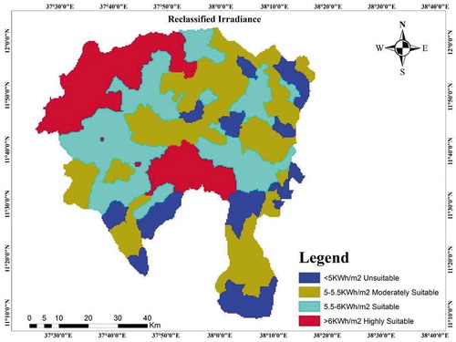
As the national renewable energy laboratory report, areas with 5kwh/m2 solar irradiance per day are economically feasible (Mentis et al., Citation2015). Therefore, areas less than this threshold value per day are considered as unsuitable in the study (Table ).
Table 5. Solar irradiance reclassification
The raster solar irradiance was reclassified to unsuitable (<5), moderately suitable (5–5.5), suitable (5.5–6), and highly suitable (>6) KWh/m2 per day, respectively (Figure ).
As shown in the figure below, the North-West and South part of the study area is highly suitable for solar energy installation whereas the Western and the eastern part is suitable.
Figure 1. Irradiance reclassified
2.2.2. Roads reclassification
Transportation cost is another important factor for any power plant installations since the cost required to reach all spare parts to the selected site will be significant. Thus, areas far from roads are economically infeasible and unsuitable for solar site selection (Shorabeh et al., Citation2019)(Ghasempour et al., Citation2019). As a result, areas whose distance is less than 500 m are selected as highly suitable sites for solar power plant installation whereas areas with distance (500–1000 m) suitable, (1000–1500 m) moderately suitable and greater (1500 m) unsuitable were prioritized, respectively (Figure ). The Euclidean distance was used for road data set reclassifications in ArcGIS tool and the Euclidean distance are reclassified as below (Table ).
Figure 2. Roads reclassification
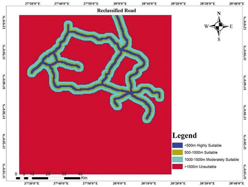
Table 6. Road reclassification
2.2.3. Reclassification of slope
The surface of the earth is also another important factor in finding suitable locations for solar power plant. The earth gradient remarkably affects the receiving radiation from the sun. Thus, flatter areas receive more radiation and produce more power from solar PV modules.
Areas less than 3% gradient were classified as highly suitable and greater than 10% gradient was unsuitable (Figure ) (Capasso et al., Citation2019). The slope was categorized as highly suitable (3%), suitable (3–7%), moderately suitable (7–10%), and greater than (>10%) was unsuitable (Table ).
Figure 3. Reclassified slope
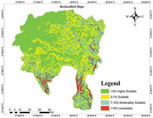
Table 7. Slope reclassification
2.2.4. Land use-land cover
Land use land cove is also another key factor in finding optimal location solar PV power plant. Cultivated/agricultural areas, forest areas, urban areas were excluded in this scenario (Shiraishi et al., Citation2019)(Majumdar & Pasqualetti, Citation2019). The open areas were considered as highly suitable areas for solar power plant installations (Figure ).
Figure 4. Reclassified land use-land cover

2.2.5. Distance from town
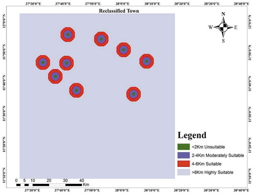
Distance from towns was determinant factor in identifying suitable sites for solar PV power plant (Tunc et al., Citation2019)(Gil-García et al., Citation2019). The farthest distance from town was considered as highly suitable and the shortest was considered as unsuitable for solar PV in this study (Table ).
Table 8. Town reclassification
The town datasets were reclassified to highly suitable (>6 km), suitable (4–6 km), moderately suitable (2–4 km), and unsuitable (<2 km) (Figure ).
Figure 5. Reclassified town
2.2.6. Distance from protected areas
Historical paces, recreation areas, schools, health posts, health centers and churches were excluded in indicating optimal locations for solar PV power plant (Home-Ortiz et al., Citation2019). Based on the nature of the study area, the distance from these protected areas were reclassified into four categories i.e less than 300 m, 300–400 m, 400–1000 m, and greater than 1000 m (Table ). The farthest distance from protected were considered as highly suitable areas and the shortest distances were considered as the unsuitable sites for solar PV power plant (Figure ).
Figure 6. Reclassified protected area
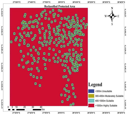
Table 9. Protected areas reclassification
2.2.7. Distance from water bodies
The solar power plant locations were affected by the water bodies (Jones et al., Citation2019)(Asakereh et al., Citation2014). The farthest locations were the more suitable locations. The water bodies were reclassified into four main categories depending on the distance from these sites. The farthest locations were taken as more suitable and the nearest locations were taken as unsuitable (Figure ). The distance greater than (2000 m) highly suitable, (1000–2000 m) Suitable, (500–1000) moderately suitable, and less than 500 m was unsuitable, respectively (Table ).
Figure 7. Reclassified water body
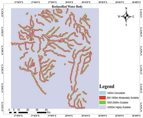
Table 10. Stream reclassification
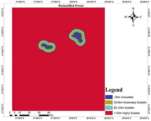
2.2.8. Distance from forest
Distance from forest was the dominant factor for solar PV power plant site selection (Al Garni & Awasthi, Citation2017). The solar radiation is highly affected by forest shadow. Thus, farthest the distance from the forest was considered as the most suitable and the nearest distance was considered as unsuitable locations (Table ).
Table 11. Forest reclassification
The forest dataset was reclassified into four main classes in this paper, greater than (120 m) highly suitable, (80–120) suitable, (30–80 m) moderately suitable, and less than (30 m) unsuitable (Figure ).
Figure 8. Reclassified Forest
2.3. Wind farm site selection criteria
Similarly, to the procedures followed in determining suitable locations for solar power plant installation, suitable site selection for wind farms requires set of factors to determine suitability of a particular area. Geographic information system (GIS) and ArcGIS were used to determine the appropriate sites for wind farm. ArcGIS can prioritize the site to determine the most suitable sites. To find the most suitable areas for wind farm location, eight data sets were taken as a layer. These data sets were average wind speed, roads, forest, water bodies, protected areas, town, slope and land use land cover.
The study area was then ranked to identify the most suitable sites, and the potential locations for wind farm were prioritized, as highly suitable, suitable, moderately suitable, and unsuitable.
2.3.1. Average wind speed reclassification
The average wind speed was the most important factor to determine the suitable site for wind farm. The dataset was taken from National Aeronautics and space (NASA) surface metrology since it is impossible to obtain instrumental (record) wind speed data of the study area(CitationR. Manufacturing)(Sengupta et al., Citation2018).
Areas with 3.5–5 m/s average wind speed at 25 m height are not economically feasible (Cui & Caracoglia, Citation2018). Thus, areas in between (3.5–5 m/s) average wind speed are considered as unsuitable in the study (Table ). The average wind speed was reclassified into unsuitable (3.5–5 m/s), moderately suitable (56 m/s), suitable (6–7 m/s), and highly suitable (>7 m/s).
Table 12. Wind speed reclassification
2.3.2. Roads reclassification
The most challenging factor for wind power plant installation is the transportation cost since the towers are too large (Solangi et al., Citation2018). Therefore, transportation cost is important factor for wind power plant installations. Thus, the areas far from roads are economically infeasible and unsuitable. This study considers the cost and visual of disturbance wind turbines. Consequently, areas between (5,005,000 m) from main roads were selected as highly suitable sites for wind farm. Areas with distance (5000–10,000 m) suitable, (10,000–20,000 m) moderately suitable and greater (20,000 m) unsuitable were prioritized, respectively.
The Euclidean distance was used for road data reclassifications in ArcGIS tool and the Euclidean distance were reclassified as below (Table ).
Table 13. Road reclassification
2.3.3. Reclassification of slope
Nature of the earth surface was important factor in identifying suitable site for wind farm. The earth gradient affects the coming wind speed to the turbine. The flat areas also receive less wind speed and extract less power from wind farm (Alcalá et al., Citation2019).
Areas less than 15% gradient were classified as highly suitable and greater than 20% gradient was unsuitable. The slope reclassification data sets were categorized into four main categories (Table ).
Table 14. Slope reclassification
2.3.4. Distance from town
Distance from towns was another important factor in finding suitable sites for wind power plants (Ghasempour et al., Citation2019)(Gil-García et al., Citation2019). Wind turbine causes visual disturbance to environment of aesthetic beauty. Thus, distance less 2 km from town was considered unsuitable and distance greater than 50 km was considered as unsuitable for wind farm in this study (Table ).
Table 15. Town reclassification
The town data set were reclassified to highly suitable (5–10 km), suitable (10–15 km), moderately suitable (15–30 km), and unsuitable (>30 km).
2.3.5. Distance from protected areas
Historical paces, recreation areas, and churches were excluded in indicating optimal sites for wind power plants (Home-Ortiz et al., Citation2019). Depending on the nature of the study area, the distances from protected were reclassified into four categories.
Thus, areas less than 4 km (Unsuitable), 4–8 km (moderately suitable), 8–10 km (suitable) and greater than 10 km (highly suitable) for wind power plants (Table ).
Table 16. Protected reclassification
2.3.6. Distance from water bodies
Water bodies were important factors in finding suitable sites for wind farms (Koc et al., Citation2019). The water bodies were reclassified into four main categories depending on the distance from the sites. The farthest locations were taken as more suitable and the nearest locations were taken as unsuitable. The distance greater than (5 km) highly suitable, (3–5 km) suitable, (1–3 km) moderately suitable, and less than 500 m was unsuitable, respectively (Table ).
Table 17. Water bodies reclassification
2.3.7. Distance from forest
Distance from forest was another factor for wind power plant site selection (Koc et al., Citation2019). Forest block coming wind speed to wind turbine and cause wind turbine damage. Thus, farthest the distance from the forest was considered as the most suitable and the nearest distance was considered as unsuitable locations (Table ).
Table 18. Forest reclassification
The forest dataset was reclassified into four main classes in this paper, distance (>20 km) highly suitable, (10–20 km) suitable, (5–10 km) moderately suitable, and greater than (<5 km) unsuitable.
2.4. Grid routing criteria
Suitable path selection for grid connection requires set of factors to find suitable path of a particular area. Geographic information system (GIS) and ArcGIS were used to indicate the appropriate path for the national grid. ArcGIS can prioritize the ways to determine the most suitable path. To determine the most suitable path for national grid, eight data sets were taken as layer. Thus, data sets were distance from national grid tapping point, roads, forest, water bodies, protected areas, town, slope, and land use land cover. The study area was ranked to identify the most suitable path, and the path was prioritized, as highly suitable, suitable, moderately suitable, and unsuitable.
2.4.1. Distance from national grid
Distance from national grid is most important factor to connect load to national grid (Machrafi, Citation2012). Thus, the areas far from national grid are economically infeasible and unsuitable. This study considers the cost and technical power loss. Therefore, areas less distance (20 km) from national grid were selected as highly suitable sites for national grid connection. Areas with distance (20–60 km) suitable, (60–100 km) moderately suitable, and greater (100 km) unsuitable were prioritized, respectively (Table ).
Table 19. Distance from national grid reclassification
2.4.2. Roads reclassification
Transportation cost is an important factor in finding the best routing (Bahaj et al., Citation2019). Thus, the areas far from roads are economically infeasible and unsuitable. This study considers the cost transmission line cost. Therefore, areas less than (500 m) from main roads were selected as highly suitable sites for wind farm. Areas with distance (500–5000 m) suitable, (5000–8000 m) moderately suitable, and greater (8000 m) unsuitable were prioritized, respectively.
The Euclidean distance was used for road data reclassifications in ArcGIS tool and the Euclidean distance are reclassified (Table ).
Table 20. Road reclassification
2.4.3. Distance from town
Distance from towns was a determinant factor in finding suitable routing for grid connection (Du & Cheng, Citation2018). Electric transmission line causes for shock to human and health effects. Thus, the town data set was reclassified to highly suitable (1–3 km), suitable (3–5 Km), moderately suitable (5–6 Km), and unsuitable (>6 Km) (Table ).
Table 21. Town reclassification
2.4.4. Distance from water bodies
Water bodies were important factors in finding a suitable path for grid connection (Mat Isa et al., Citation2017). The water bodies were reclassified into four main categories depending on the distance from the site. The farther path from water bodies were taken as more suitable and the nearest were taken as unsuitable. The distance greater than (5000 m) highly suitable, (3000–5000 m) Suitable, (500–3000 m) moderately suitable, and less than 500 m was unsuitable, respectively (Table ).
Table 22. Water bodies reclassification
2.4.5. Distance from forest
Distance from forest was another factor for nation grid path site selection (Bertheau et al., Citation2017). Forest may cause transmission line damages and power system unreliability. Thus, farthest the distance from the forest was considered as the most suitable and the nearest distance was considered as unsuitable locations (Table ).
Table 23. Forest reclassification
The forest dataset was reclassified into four main classes in this paper, distance (>4 km) highly suitable, (3–4 km) suitable, (2–3 km) moderately suitable, and less (<2 km) unsuitable.
2.4.6. Distance from protected areas
Historical paces, recreation areas and churches were excluded in finding optimal routing for national grid connection (Aklin et al., Citation2018). Depending on the nature of the study area, the distances from protected were reclassified into four categories. Thus, areas less than 2 km (Unsuitable), 2–3 km (moderately suitable), 3–4 km (suitable), and greater than 4 km (highly suitable) for national grid connection (Table ).
Table 24. Protected reclassification
2.4.7. Reclassification of slope
Topology of the earth surface was important factor in identifying suitable path for national grid connection (Da Reginato & Julião, Citation2019). The earth gradient affects pole erection for national grid explanations. The flat areas are the most suitable areas for pole erection.
Areas less than 2% gradient were classified as highly suitable and greater than 10% gradient was unsuitable. The slope reclassification data sets were categorized into four main categories (Table ).
Table 25. Slope reclassification
2.5. Result and discussion
2.5.1. Weighted overlay of solar PV suitability analysis
All weights of the criteria were combined by using ArcGIS10.4.1 weight overlay tool. The reclassified data set of the criteria which include solar irradiance, distance from roads, distance from protected areas, and distance from town, slope, and distance from forest, and land use-land cover were overlaid to the aggregate base on its weight.
The final map of suitability was obtained by multiplying each reclassified value with each weight value and summing up all layer products. From the result obtained, solar power plants are best options to electrify the Western, South-West and North-West parts of the district whereas the majority parts of the study area are found to be unstable (Figure ).
The range of solar PV suitability was from one to four. Thus, study area was separated into four main categories. Highly suitable and suitable areas are considered as suitable options for solar PV electrification whereas the remaining areas are moderately suitable and totally unsuitable. More than half of the total area is suitable for solar energy electrification (Table ). 55.585 % of the total area is found to be feasible for electrification through solar energy whereas 44.415% is not suitable for solar power plant installation. 2897.742 Square kilometer is found to be suitable. The North-West and some Southern part of the study area is highly suitable for electrification using solar energy.
Figure 9. Solar weighted overlay
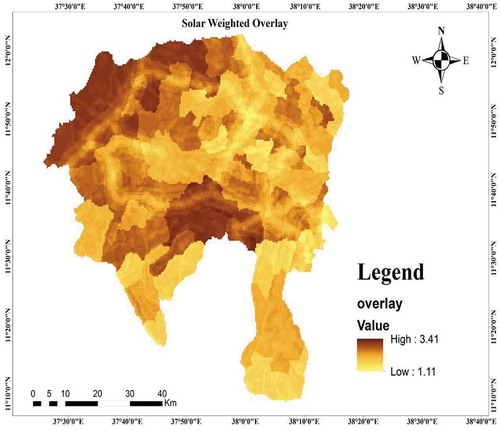
Table 26. Suitability rank for solar power plant
2.5.2. Weighted overlay of wind suitability analysis
Weights of wind power criteria were combined by using ArcGIS10.4.1 weight overlay tool. The criteria include average wind speed, distance from roads, distance from protected, and distance from town, slope, and distance from forest, water bodies, and land use land cover were overlaid for aggregate mapping. Similarly, wind energy is best alternative to electrify the North-East, South-West, and the Northern part of the study area (Figure ). Wind power suitability was found by multiplying each reclassified value with each weight value and summing up all layer products. The suitability of wind plant was ranged from one to four of which highly suitable areas for placing wind farm was Value was one (Table ). 54.267% of the total area is found to be feasible for electrification through wind energy whereas 45.733% is not suitable for wind power plant installation. 2836.134 square kilometer is found to be suitable. The North-East and some central and Western parts of the study area are highly suitable for electrification using wind energy.
Figure 10. Wind weighted overlay
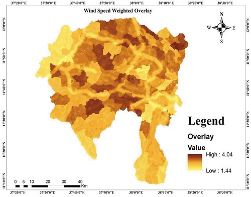
Table 27. Suitability rank for wind power plant
2.5.3. Weighted overlay of national grid routing suitability analysis
In similar way to the previous, weights of national grid connection criteria were combined by using ArcGIS10.4.1 weight overlay tool. The criteria include distance from national grid, distance from roads, distance from protected, and distance from town, slope, and distance from forest, water bodies, and land use land cover were overlaid for aggregate mapping (Figure ).
Suitable path for grid was found by multiplying each reclassified value with each weight value and summing up all layer products. The suitability of grid connection was ranged from one to four of which highly suitable areas for connecting to grid was Value was one (Table ). 15.351 % of the total area is found to be feasible for electrification through grid extension whereas 84.649% is not suitable for electrifying by extending the national grid. 802.003 square kilometer area is found to be suitable. The North-West and some Southern part of the study area is highly suitable for electrification using grid extension.
Figure 11. Grid weighted overlay
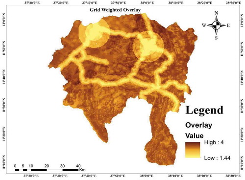
Table 28. Suitability rank for grid extension
3. Conclusion
Solar energy was the optimal options for most of area in the South Gonder Zone followed by wind energy. This potential contributes to increase access to electricity if the country starts to use such proper planning options for rural electrification. Solar irradiance, towns, slope, land use land cover, forest, water bodies and protected areas are determinant factors in finding optimal energy options for particular area in the south Gonder Zone. From the overlaid, the study area covers 5226.289 square kilometers from which 2897.742, 2836.134, and 802.003 square kilometer is suitable for electrification using solar, wind and grid extension, respectively.
Further studies should investigate optimal energy options for rural electrification by integrating AHP with fuzzy. Additionally, design and mathematical modeling of optimal options should be investigated by future work.
Abbreviations
GIS: Geographic information system; AHP: Analytic Hierarchy Process; GW: Giga Watt; PV: Photovoltaic
Conflicts of interest
The author declares that there is no conflict of interest in regard to the publication of this paper.
Acknowledgements
We would like to acknowledge our friends who were very interested, encouraged and helped us to do these research projects. We also thank Ethiopian Electric power workers to their permission to give necessary information to conduct the research.
Data availability statement
The date of this study will be shared as the authors requested.
Additional information
Funding
Notes on contributors
Biniyam Zemene Taye
Mr. Biniyam Zemene Taye is a lecturer at faculty of electrical and computer engineering, Bahir Dar Institute of Technology. He obtained his first degree in Electrical Engineering in Adama University and his second degrees in Electrical Power Engineering in Bahir Dar University.
Tewodros Gera Workineh
Mr. Tewodros Gera Workineh is a lecturer at faculty of electrical and computer engineering, Bahir Dar Institute of Technology. He obtained his first and second degrees in Electrical Power Engineering in Adama University.
Abraham Hizikiel Nebey
Mr. Abraham Hizkiel Nebey is a lecturer at faculty of electrical and computer engineering, Bahir Dar Institute of Technology. He obtained his first degree in Electrical Power Engineering in Debre Markos University and second degree in Electrical Power System Engineering in Bahir Dar University.
Habtemariam Aberie Kefale
Mr. Habtemariam Aberie Kefale is a lecturer at faculty of electrical and computer engineering, Bahir Dar Institute of Technology. He obtained his first and second degrees in Electrical Power Engineering in Bahir Dar University.
References
- Aklin, M., Cheng, C. Y., & Urpelainen, J. (2018). Social acceptance of new energy technology in developing countries: A framing experiment in rural India. Energy Policy, 113(August 2017), 466–23. https://doi.org/http://doi.10.1016/j.enpol.2017.10.059
- Al Garni, H. Z., & Awasthi, A. (2017). Solar PV power plant site selection using a GIS-AHP based approach with application in Saudi Arabia. Applied Energy, 206(September), 1225–1240. https://doi.org/http://doi.10.1016/j.apenergy.2017.10.024
- Alami Merrouni, A., Elwali Elalaoui, F., Ghennioui, A., Mezrhab, A., & Mezrhab, A. (2018). A GIS-AHP combination for the sites assessment of large-scale CSP plants with dry and wet cooling systems. Case study: Eastern Morocco. Solar Energy, 166(September 2017), 2–12. https://doi.org/http://doi.10.1016/j.solener.2018.03.038
- Alcalá, G., Perea-Moreno, A. J., & Hernandez-Escobedo, Q. (2019). Wind Resource Assessment using Weibull Function for Different Periods of the Day in the Yucatan Peninsula. Chemical Engineering Transactions, 76, 1003–1008. https://doi.org/http://doi.10.3303/CET1976168
- Asakereh, A., Omid, M., Alimardani, R., & Sarmadian, F. (2014). Developing a GIS-based fuzzy AHP model for selecting solar energy sites in shodirwan region in Iran. International Journal of Advanced Science and Technology, 68, 37–48. https://doi.org/http://doi.10.14257/ijast.2014.68.04
- Bahaj, A. B., Blunden, L., Kanani, C., James,P., Kiva, I., Matthews, Z., Price, H., Essendi, H., Falkingham, J., & George, G. (2019). The impact of an electrical mini-grid on the development of a rural community in Kenya. Energies, 12(5), 1–21. https://doi.org/http://doi.10.3390/en12050778
- Bertheau, P., Oyewo, A. S., Cader, C., Breyer, C., & Blechinger, P. (2017). Visualizing national electrification scenarios for sub-saharan African countries. Energies, 10(11), 1–20. https://doi.org/http://doi.10.3390/en10111899
- Capasso, L., Diana, A., Manca, O., Nardini, S., & Vigna, S. (2019). Numerical investigation on a solar chimney in a building façade under different climatic condition. Tecnica Italiana-Italian Journal of Engineering Science, 63(2–4), 409–416. https://doi.org/http://doi.10.18280/ti-ijes.632-443
- Cui, W., & Caracoglia, L. (2018). A unified framework for performance-based wind engineering of tall buildings in hurricane-prone regions based on lifetime intervention-cost estimation. Structural Safety, 73, 75–86. https://doi.org/http://doi.10.1016/j.strusafe.2018.02.003
- da Reginato, V. S. C., & Julião, R. P. (2019). Geographic modelling of wind and solar energy potential. Boletim De Ciências Geodésicas, 25(3), 0–3. https://doi.org/http://doi.10.1590/s1982-21702019000300019
- Drouin, C. (2018). Geospatial cost drivers in computer-aided electrification planning: the case of rwanda. Vol. 2012, (p. 106). [Online]. http://hdl.handle.net/1721.1/115656.
- Du, M., & Cheng, L. (2018). Better understanding the characteristics and influential factors of different travel patterns in free-floating bike sharing: Evidence from Nanjing, China. Sustain, 10(4). https://doi.org/http://doi.10.3390/su10041244
- Falchetta, G., Pachauri, S., Parkinson, S., & Byers, E. (2019). A high-resolution gridded dataset to assess electrification in sub-Saharan Africa. Scientific Data, 6(1), 1–9. https://doi.org/10.1038/s41597-019-0122-6
- Ghasempour, R., Nazari, M. A., Ebrahimi, M., Ahmadi, M. H., & Hadiyanto, H. (2019). Multi-criteria decision making (MCDM) approach for selecting solar plants site and technology: A review. International Journal of Renewable Energy Development, 8(1), 15–25. https://doi.org/http://doi.10.14710/ijred.8.1.15-2
- Gil-García, I. C., García-Cascales, M. S., Fernández-Guillamón, A., & Molina-García, A. (2019). Categorization and analysis of relevant factors for optimal locations in onshore and offshorewind power plants: A taxonomic review. Journal of Marine Science and Engineering, 7(11), 1–21. https://doi.org/http://doi.10.3390/jmse7110391
- Home-Ortiz, J. M., Pourakbari-Kasmaei, M., Lehtonen, M., & Sanches Mantovani, J. R. (2019). Optimal location-allocation of storage devices and renewable-based DG in distribution systems. Electric Power Systems Research, 172(March), 11–21. https://doi.org/http://doi.10.1016/j.epsr.2019.02.013
- Hysa, A. (2019). Modeling and simulation of the photovoltaic cells for different values of physical and environmental parameters. Emerging Science Journal, 3(6), 395–406. https://doi.org/http://doi.10.28991/esj-2019-01202
- Jones, E., Qadir, M., van Vliet, M. T. H., Smakhtin, V., & Mu Kang, S. (2019). The state of desalination and brine production: A global outlook. Science of the Total Environment, 657(December 2018), 1343–1356. https://doi.org/http://doi.10.1016/j.scitotenv.2018.12.076
- Koc, A., Turk, S., & Şahin, G. (2019). Multi-criteria of wind-solar site selection problem using a GIS-AHP-based approach with an application in Igdir Province/ Turkey. Environmental Science and Pollution Research, 26(31), 32298–32310. https://doi.org/http://doi.10.1007/s11356-019-06260-1
- Korkovelos, A., Khavari, B., Sahlberg, A., Howells, M., & Arderne, C. (2019). The role of open access data in geospatial electrification planning and the achievement of SDG7. An onsset-based case study for Malawi. Energies, 12(7), 1395. https://doi.org/http://doi.10.3390/en12071395.
- Machrafi, H. (2012). Green Energy and Technology.
- Majumdar, D., & Pasqualetti, M. J. (2019). Analysis of land availability for utility-scale power plants and assessment of solar photovoltaic development in the state of Arizona, USA. Renewable Energy, 134(September 2018), 1213–1231. https://doi.org/http://doi.10.1016/j.renene.2018.08.064
- Mat Isa, N., Wei Tan, C., & Yatim, A. H. M. (2017). A techno-economic assessment of grid connected photovoltaic system for hospital building in Malaysia. IOP Conference Series: Materials Science and Engineering, 217(1). https://doi.org/http://doi.10.1088/1757-899X/217/1/012016
- Mentis, D., Welsch, M., Nerini, F. F., Broad, O., Howells, M., Bazilian, M., & Rogner, H. (2015). A GIS-based approach for electrification planning-A case study on Nigeria. Energy for Sustainable Development, 29(DECEMBER), 142–150. https://doi.org/http://doi.10.1016/j.esd.2015.09.007
- Michael, A., “www.econstor.eu,” 2018.
- Mondal, M. H. A., Gebremeskel, A. G., Gebrehiwot, K., & Ringler, C., “Ethiopian universal electrification development strategies,” p. 4, 2018, [Online]. http://ebrary.ifpri.org/cdm/ref/collection/p15738coll2/id/132767.
- Qerimi, D., Dimitrieska, C., Vasilevska, S., & Rrecaj, A. A. (2020). Modeling of the solar thermal energy use in urban areas. Journal of Civil Engineering, 6(7), 1349–1367. https://doi.org/http://doi.10.28991/cej-2020-03091553
- R. Manufacturing. Universal and compatible. Forschung, m.
- Ramík, J. (2017). Ranking alternatives by pairwise comparisons matrix and priority vector. Scientific Annals of Economics and Business, 64(Specialissue), 85–95. https://doi.org/http://doi.10.1515/saeb-2017-0040
- Sedrati, M., Maanan, M., & Rhinane, H. (2019). PV power plants sites selection using gis-fahp based approach in north-western morocco. International Archives of the Photogrammetry, Remote Sensing and Spatial Information Sciences (ISPRS Archives), 42(4/W19), 385–392. https://doi.org/http://doi.10.5194/isprs-archives-XLII-4-W19-385-2019
- Sengupta, M., Xie, Y., Lopez, A., Habte, A., Maclaurin, G., & Shelby, J. (2018). The national solar radiation data base (NSRDB). Renewable and Sustainable Energy Reviews, 89(September 2017), 51–60. https://doi.org/http://doi.10.1016/j.rser.2018.03.003
- Shiraishi, K., Shirley, R. G., & Kammen, D. M. (2019). Geospatial multi-criteria analysis for identifying high priority clean energy investment opportunities: A case study on land-use conflict in Bangladesh. Applied Energy, 235(August 2018), 1457–1467. https://doi.org/http://doi.10.1016/j.apenergy.2018.10.123
- Shorabeh, S. N., Firozjaei, M. K., Nematollahi, O., Firozjaei, H. K., & Jelokhani-Niaraki, M. (2019). A risk-based multi-criteria spatial decision analysis for solar power plant site selection in different climates: A case study in Iran. Renewable Energy, 143, 958–973. https://doi.org/http://doi.10.1016/j.renene.2019.05.063
- Solangi, Y. A., Tan, Q., Khan, M. W. A., Mirjat, N. H., & Ahmed, I. (2018). The selection of wind power project location in the Southeastern Corridor of Pakistan: A factor analysis, AHP, and fuzzy-TOPSIS application. Energies, 11(8). https://doi.org/http://doi.10.3390/en11081940
- Tunc, A., Tuncay, G., Alacakanat, Z., & Sevimli, F. S. (2019). Gis based solar power plants site selection using analytic hierarchy process (ahp) in istanbul, Turkey. International Archives of the Photogrammetry, Remote Sensing and Spatial Information Sciences (ISPRS Archives), 42(2/W13), 1353–1360. https://doi.org/http://doi.10.5194/isprs-archives-XLII-2-W13-1353-2019
- Wang, C. N., Nguyen, V. T., Thai, H. T. N., & Duong, D. H. (2018). Multi-criteria decision making (MCDM) approaches for solar power plant location selection in Viet Nam. Energies, 11(6), 1504. https://doi.org/http://doi.10.3390/en11061504
- Yousefi, H., Hafeznia, H., & Yousefi-Sahzabi, A. (2018). Spatial site selection for solar power plants using a gis-based boolean-fuzzy logic model: A case study of Markazi Province, Iran. Energies, 11(7), 1648. https://doi.org/http://doi.10.3390/en11071648