
 ?Mathematical formulae have been encoded as MathML and are displayed in this HTML version using MathJax in order to improve their display. Uncheck the box to turn MathJax off. This feature requires Javascript. Click on a formula to zoom.
Abstract
Satellite remote sensing of near real-time reservoir filling has important implications for the monitoring of territorial hydrological resources. These tasks are particularly relevant for reservoirs whose ground hydrological characteristics are not accessible. The monitoring of reservoir filling demands bathymetric data or satellite altimetry. However, bathymetry and satellite altimetry data, which are essential for estimating water storage variations, are only available for a limited number of reservoirs. Another possibility is to combine satellite monitoring of the water mirror with data from the Digital Terrain Model (DEM). In this research, we suggest using global DEM to estimate the slope of a reference alluvial inflow cone entering a reservoir, such as a riverbed. Satellite monitoring of the water mirror creates a set of coastlines at different reservoir fills. The spatial location of coastlines on a reference alluvial cone with a known slope allows altimetric linking of water mirrors. The resulting set of altimetrically referred water mirrors gives the possibility to reconstruct the reservoir 3D bed characteristics. The 3D model of the reservoir bed is constructed as a set of layers. Each layer is a truncated pyramid. Pyramid bases are the neighboring altimetric reference water mirrors. The Kapshagay reservoir (Northwest China) on the River Tekes which is the main tributary of the cross-border (Kazakhstan-China) River Ili was considered as an example. Landsat-5,7,8 (resolution 30 m) data for the period 2007–2018 were used to monitor the water mirror area of the Kapshagay reservoir, which varies from 22 to 59 km2. Shuttle Radar Topography Mission (SRTM) was used as DEM. The nine-layer 3D model of the reservoir bed was created. The operation volume of the reservoir is estimated at 1,37 ± 0,08 km3, which is close to the official 1,4 km3. The empirical equation of the relationship between the mirror area and the water storage in the operating part of the reservoir, received as a result of 3D model calculations, is the basis for operational hydrological monitoring of objects that do not have access to ground data.
PUBLIC INTEREST STATEMENT
Satellite monitoring of water mirrors and global digital elevation models can help when information is needed about the fullness of an artificial reservoir of variable size. The methodology for estimating the water deposit of reservoirs uses information on the terrain slope and the coastline positions. In mid-mountain landscapes, if the reservoir is located on a uniform slope, it is possible to monitor the water deposit of reservoirs with an area of several tens of km2. This approach can be useful in arid climate zones (water scarcity) for monitoring artificial water bodies located in transboundary river basins on the territory of neighboring countries. In this case, satellite measurements of water deposits can be used to verify available foreign ground data or be the main source of information. This is relevant for the Central Asian countries, for example, Kazakhstan and Northwest China.
1. Introduction
Human-made reservoirs, which are managed by storing and releasing water under predetermined operation rules, especially in transboundary river basins, play an important role in improving the efficiency of the territorial water supply (Bai et al., Citation2015; Haddeland et al., Citation2014; Zhao et al., Citation2016). Although most human-operated reservoirs are monitored in real-time, reservoir storage information is not collected by international organizations, for example, such as the World Meteorological Organization, and there are limitations on its availability to the public. This limits the effectiveness of reservoir flow regulation, especially within transboundary river basins. Due to the limited availability of gauge observations remote sensing technology provides a promising alternative (Berry et al., Citation2005; Gao et al., Citation2012; Lettenmaier et al., Citation2015; Li et al., Citation2019; Pereira et al., Citation2019; Rodrigues et al., Citation2012; Yao et al., Citation2019). With remotely sensed water surface area and elevation data, reservoir storage information can be inferred. Reservoir surface area is commonly estimated by classifying optical satellite imageries (Kornienko, Citation2017; Wang et al., Citation2013; Yao et al., Citation2019; Zhang & Gao, Citation2020) and surface elevation values are typically obtained from satellite radar altimetry (Berry et al., Citation2005; Birkett, Citation1998) or ground bathymetry data. Even though a variety of remote sensing approaches were developed to monitor reservoir storage from space (Busker et al., Citation2019; Liebe et al., Citation2005; Smith & Pavelsky, Citation2009), they are still insufficient in terms of spatial and temporal coverage in case of small objects with water mirrors about 20–60 km2. Water surface area from Landsat and the elevation relationship provided by the Shuttle Radar Topography Mission (SRTM) were combined to infer the water level and reservoir storage variations (Bonnema & Hossain, Citation2017; Getirana et al., Citation2018; Tseng et al., Citation2016) Sentinel-2A and Landsat-5,7,8 can be used to estimate water surface area for smaller reservoirs due to its high spatial resolution (10–30 m). However, its repeat period of 5–16 days gives the possibility to monitor reservoir storage at a high temporal resolution only in case of arid climate when cloud coverage is small.
The deficient communications with regard to reservoir storage further exacerbate the casualties and economic losses in the water-deficit arid climate for transboundary river basins. Therefore, acquiring reservoir storage information in the upper part of the transboundary river basin is critical for minimizing the vulnerabilities and maximizing the economic benefits in the down part river basin through good irrigation arable land and reservoir management practices. But the accuracy of the global DEM is limited (Schumann & Bates, Citation2018), which allows you to analyze water storage only for large objects. Analysis of smaller reservoirs requires additional clarifying procedures. The SRTM DEM was used to extract the elevation relationship for calculating reservoir storage in this study. In the case of reservoirs built after 2000, SRTM provides information about the digital elevation model of its bottom (bathymetry). Our overarching goal was to improve the spatial description of the remotely sensed reservoir storage dataset with help of using a set of coastlines. Coastlines can be used as equilibrium line altitudes (ELA), the accuracy of which much better than SRTM-DEM data.
The purpose of this study is to consider the possibility of creating a 3D model of the small reservoir bed based on remote sensing of coastlines and global DEM using the example of the Kapshagay reservoir (Northwest China), transboundary River Ile (China-Kazakhstan) basin.
2. Study area
The transboundary river Ile (China-Kazakhstan), with a length of 1439 km and 12 km3 of annual runoff at the China-Kazakhstan border, collects water in the Eastern and Northern Tien Shan ridges, . The sharply continental climate of the Tien Shan mountains leads to significant annual variations in the territory’s moisture content and river runoff (Terekhov et al., Citation2020). The Kapshagay reservoir was built in 2006 on River Tekes (the largest tributary of the River Ile) in the Chinese part of the transboundary River Ile basin. In Landsat-5,7,8 data, the reservoir enters the WRS-2: Path\Row 146 × 30 scene. The Kapshagay reservoir was chosen as the object of this study, . It should be noted that there is another large reservoir on the Ili river (area of 1800 km2, volume 28 km3) with the same name, but on the territory of Kazakhstan.
The Kapshagay reservoir on the river Tekes (China) is located at an altitude of about 1000 m above sea level. Depending on the degree of seasonal filling, the water mirror is about 50 km2 (Terekhov & Pak, Citation2019). The reservoir operates in an energy mode, i.e. replenishing occurs in the summer, and operating in the cold period (Terekhov et al., Citation2015), . In a dry year, the operation of the reservoir can have a significant impact on the river runoff (Mikhailov et al., Citation2015; Terekhov, Citation2016).
Figure 1. Study area. The basis is “Temporally smoothed NDVI” scene from USGS/EROS/FEWS NET, e-MODIS C6 (July 1–10, 2003) and Sentinel-2A (27 July 2017, resolution 20 m)
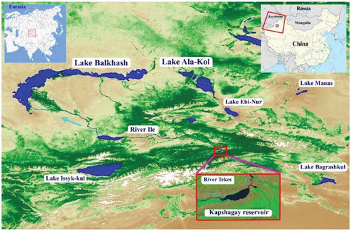
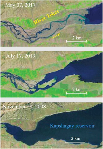
Figure 2. Examples of LANDSAT images (resolution 30 m) with different coastline positions. Fragment of Kapshagay reservoir (River Tekes, Xinjiang China) with different water levels. LandsatLook Natural Color product from (https://glovis.usgs.gov/app)
3. Methods
3.1. General principles
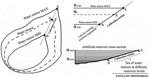
Reservoirs are important in the economy of the territories. The water stored in the reservoir is mainly used for power generation and irrigation of arable land, which leads to seasonal variations in the reservoir’s water deposit. To determine the current water deposit, we need to know how the water level and the area of the mirror changes. The area of the water mirror can be easily monitored by satellite monitoring. The water level in a reservoir can be determined in several ways: at a hydrometric station, as the distance between the water surface and a reference level; using remote radar altimetry (satellites, aircraft, etc.); or using DEM, when the position of the coastline is compared with a digital terrain model. The proposed method is a variation of the DEM-based water level assessment methodology. When considering small reservoirs, changes in the position of the coastline may be insignificant, up to a few pixel positions in the DEM matrix. To reduce the level of errors, the altimetric reference of the water mirror is based not on comparing the position of the coastline with single DEM pixels, but by taking into account its position on a long uniform slope. The slope of an extended territory can be determined using DEM with fewer errors than the single pixels of the DEM matrix. For altimeter linking of water mirrors at different water levels, we must to choose a fragment of the periodically drained bottom of the reservoir, which is a plain with a constant angle of inclination. The riverbed can often be described using this model. The transported suspended material in the river is deposited on the bends of the slope (if any), which ensures that the slope is uniform.
The estimation of changes in reservoir filling can be based on satellite monitoring of water mirrors and global DEM data. This approach is based on the registration of coastline positions at different water levels in reservoir and mirror elevations. When considering a relatively small reservoir the changes in coastline positions may be minor, up to a few pixel positions in the global DEM matrix. Accordingly, there appears a problem with the accuracy of the altimetric water mirror reference. The solution to this problem may be to consider the extreme values for reservoir fullness, the position of the coastline in the case of a multi-year minimum and maximum. The altimetry of maximally spaced points on the DEM matrix can be determined better. For altimetric linking of water mirrors of intermediate stages of reservoir filling, it is necessary to select a place for analyzing the positions of coastlines and determine the geometric shape of the surface of this periodically draining bottom. In the simplest case, it is an inclined plane characterized by a certain angle of slope. A riverbed located in an alluvial outflow cone can very often be described by this model. The transferred suspended material in the river is deposited at the bends of the slope (if any), which ensures uniformity of the slope.
In the framework of this model, the extreme positions of coastlines (min\max water mirror) received from satellite reservoir monitoring determine the calibration segment. To determine the water mirror elevation (Hx), it is sufficient to have three parameters: the minimum (Hmin) and maximum (Hmax) of water mirror elevation and the coastline position of the analyzed water mirror on the calibration segment, . The analyzed water mirror elevation (Hx) can be determined according to Equationequation (1)(1)
(1) :
A set of altimetrically linked water mirrors that display long-term variations in reservoir filling allows to determine the 3D model of the reservoir bed, in particular its operating part. A 3D model of a reservoir is required to determine the relationship between the water mirror area and reservoir storage. This relationship is the basis for satellite monitoring of the reservoir filling.
In this study, we propose to build a 3D model of a reservoir as a set of layers (Vi), each of which is formed by two adjacent water mirrors. The volume of the reservoir operating part (Vreservoir) is determined according to Equationequation (2)(2)
(2) .
Each layer is considered as a truncated pyramid with parallel bases, which are the corresponding water mirrors. The layer volume is determined according to the volume equation of the truncated pyramid (3), where Sn and Sn+1 are the areas of the water mirrors of the considered layer.
Figure 3. Concept for reservoir storage from satellite water mirror monitoring and global DEM
3.2. Kapchagay reservoir
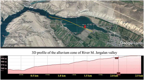
The Kapshagay reservoir on the River Tekes (Northwest China) was chosen as an illustration of the proposed method for calculating the reservoir’s water supply. During the season, this reservoir is characterized by significant variations in both: the area of the water mirror and changes in the positions of coastlines (). Part of the right-side tributary of the River M. Jergalan was selected as a calibration segment for registering f the coastline positions, . According to the SRTM-2000 v.2, the elevation difference of the water surface, from the state of a long-term minimum to a long-term maximum, is estimated at 38 meters from 963 to 1001 meters, above sea level. The distance between the extreme positions of the coastlines (min and max) on the calibration segment was about 2400 m. This is 80 Landsat pixel positions (30 m resolution). Altimetric linking of the water mirror based on coastline positions gave an 0,5 meter’s elevation step per Landsat pixel position (80 pixels per 38 m height difference). This altimetric scale is significantly higher than the SRTM-DEM.
4. Results
The USGS Global Visualization Viewer (GloVis) data portal (https://glovis.usgs.gov/app) for the period from 2007 to 2018 years has more than 200 satellite Landsat images covering the Kapchagay (River Tekes) reservoir, which are of satisfactory quality (cloud cover interference) allowing the mapping of the water mirror. The long-term minimum of the water deposit, with a water area of 22.3 ± 0.2 km2, was registered on 7 May 2017. The long-term maximum was observed on 20 November 2008, when the water area increased to 58.9 ± 0.6 km2, .
The 10 cloud-free images showing the different reservoir water levels were selected from the free GloVis satellite database. The coastlines of this water mirrors, approximately uniform steps, cover the entire range of long-term variations of the reservoir’s filling. A set of these coastlines (ELA) formed a 3D elevation model, . The operating volume of this reservoir, as the difference between the multi-year minimum and maximum of filling, according to the 3D model of the bottom, was equal to 1.37 ± 0.08 km3. This is close to official information which is declared as 1,4 km3 (Terekhov, Citation2016). The relationship between the reservoir water mirror area and its water deposit was determined also, .
Figure 4. DEM (relative scale) for Kapshagay reservoir: SRTM v.2 (resolution 90 m); ASTER GTM v.2 (resolution 30 m)
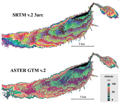
Figure 5. Google-Earth tools: SRTM profile analysis (River M.Jergalan, Kapshagay reservoir)
5. Validation
A relative root-mean-squared error of determining the water mirror area according to Landsat data is determined about 2% (Rodrigues et al., Citation2012; Yao et al., Citation2019).
Relative elevation errors of SRTM-2000 depend on landscape type (Miliaresis & Paraschou Ch, Citation2005). Global average altimetric relative error, the standard deviation is 3.4 meters (Rao et al., Citation2006). But the SRTM DEM gives more accuracy relative estimations altimetry of plains. For reservoir low-lying floodplain errors can be about 1 meter (G. P. Schumann et al., Citation2008). In a study of the River Po in Northern Italy (G. Schumann et al. (Citation2010) showed that SRTM-DEM can be used to estimate river gradients almost as reliably as LiDAR data.
The calibration section of Kapchagay reservoir has a problem with the down part, where the landscape became not plane with deflection. This is the reason why we use a higher error (2 meters). Also, taking into account this circumstance Leads to a change in the slope of the curvilinear relationship between the curve of the relationship between the water mirror area and the reservoir water deposit in a zone of a small filling.
6. Discussion
The SRTM DEM and Aster GTM v.2 data, for the bottom of the Kapshagay reservoir (River Tekes), is presented in . Visually, they are not identical. SRTM DEM looks more accurate in the large-scale parts. In Aster GTM v.2, on a small scale at all altitudes, there are systems of “holes” and “hillocks,” which contradict the alluvium slopes landscapes and are obviously artifacts. Satellite monitoring of the water mirrors at the various water levels of the reservoir does not register small “islands” and “lakes” in the coastline zone. The 3D profile of the reference alluvial slope of the M. Jergalan river valley in the SRTM DEM representation has no artifacts and silting processes are not developed here. This location was optimal for altimetric binding of water mirrors according to Equationequation 1(1)
(1) .
The main interest in practical hydrological studies in the satellite data processing was the empirical relationship between the water mirror area and the water storage in the reservoir’s operating part. An error rate of at least 10% seems sufficient for practical purposes.
7. Conclusion
A 3D model of small reservoirs can be based on global DEM data and coastlines positions retrieved from Landsat satellite monitoring. The 3D model was constructed as a set of layers formed by altimetry water elevation products at different water levels in the reservoir. Each layer was described by a truncated pyramid, where its bases are adjacent to the elevation water mirrors. Altimetric referring to water mirrors was based on the analysis of their coastline positions on the test alluvial cone of the inflow (calibration section). It was assumed that the test cone of the inflow was a simple inclined plane with an angle of inclination determined from the global DEM data based on coastline positions of the maximum and minimum water mirrors received from satellite monitoring data. As an example, the Kapchagay reservoir, located in the basin of the cross-border (China-Kazakhstan) River Ile, was considered. The empirical equation of the relationship between the mirror area and the water storage in the operating part of the reservoir, received as a result of 3D model calculations, was the basis for operational hydrological monitoring of objects that do not have access to ground data. The developed method assimilates the positions of coastlines accumulated at different reservoir water levels, that allows to describe the water deposit dynamic of small reservoirs with a water mirror area of tens of square kilometers and with a seasonal difference in the water mirror elevation within a few tens of meters.
Figure 6. Reservoir DEM (relative scale) on base of coastline set and SRTM, with [water area—reservoir filling] relationship
![Figure 6. Reservoir DEM (relative scale) on base of coastline set and SRTM, with [water area—reservoir filling] relationship](/cms/asset/8ee6668f-ce56-4d12-9646-ab6538014c81/oaen_a_1853305_f0006_oc.jpg)
Additional information
Funding
Notes on contributors
Alexey Terekhov
Alexey Terekhov, Candidate of Technical Sciences in Institute of information and computational technologies, Ministry of education and sciences, Almaty, Kazakhstan. His research interests include diagnostics of natural systems (hydrology, agriculture, etc.) based on remote sensing data, digital image analysis, statistical data analysis.

Nikolai Makarenko
Nikolai Makarenko, Doctor of Technical Sciences in Institute of information and computational technologies, Almaty, Kazakhstan, Doctor of Mathematical Sciences in Central Astronomical Observatory at Pulkovo, St. Petersburg, Russia. His research interests include topological data analysis, artificial intelligence, chaotic dynamics.
Alexander Pak
Alexander Pak, Candidate of Technical Sciences in Institute of information and computational technologies, Almaty, Kazakhstan. His research interests include topological data analysis, artificial intelligence.
Nurlan Abayev
Nurlan Abayev, in al-Farabi Kazakh National University, Almaty, Kazakhstan. His research interests include meteorology, hydrology, remote sensing and GIS application.
References
- Bai, T., Wu, L., Chang, J.-X., & Huang, Q. (2015). Multi-objective optimal operation model of cascade reservoirs and its application on water and sediment regulation. Water Resources Management, 29(8), 2751–11. https://doi.org/10.1007/s11269-015-0968-0
- Berry, P., Garlick, J., Freeman, J., & Mathers, E. (2005). Global inland water monitoring from multi-mission altimetry. Geophysical Research Letters, 32(16). https://doi.org/10.1029/2005GL022814
- Birkett, C. M. (1998). Contribution of the TOPEX NASA radar altimeter to the global monitoring of large rivers and wetlands. Water Resources Research, 34(5), 1223–1239. https://doi.org/10.1029/98WR00124
- Bonnema, M., & Hossain, F. (2017). Inferring reservoir operating patterns across the Mekong Basin using only space observations. Water Resources Research, 53(5), 3791–3810. https://doi.org/10.1002/2016WR019978
- Busker, T., de Roo, A., Gelati, E., Schwatke, C., Adamovic, M., Bisselink, B., Pekel, J.-F., & Cottam, A. (2019). A global lake and reservoir volume analysis using a surface water dataset and satellite altimetry. Hydrology and Earth System Sciences, 23(2), 669–690. https://doi.org/10.5194/hess-23-669-2019
- Gao, H., Birkett, C., & Lettenmaier, D. P. (2012). Global monitoring of large reservoir storage from satellite remote sensing. Water Resources Research, 48, W09504. https://doi.org/10.1029/2012WR012063
- Getirana, A., Jung, H. C., & Tseng, K.-H. (2018). Deriving three dimensional reservoir bathymetry from multi-satellite datasets. Remote Sensing of Environment, 217, 366–374. https://doi.org/10.1016/j.rse.2018.08.030
- Haddeland, I., Heinke, J., Biemans, H., Eisner, S., Flörke, M., Hanasaki, N., Konzmann, M., Ludwig, F., Masaki, Y., & Schewe, J. (2014). Global water resources affected by human interventions and climate change. Proceedings of the National Academy of Sciences, 111(9), 3251–3256. https://doi.org/10.1073/pnas.1222475110
- Kornienko, S. G. (2017). Analysis of errors in estimating changes in water body areas by satellite data: Case study of thermokarst lakes in Yamal Peninsula. Water Resources, 44(2), 180–192. https://doi.org/10.1134/S0097807816060038
- Lettenmaier, D. P., Alsdorf, D., Dozier, J., Huffman, G. J., Pan, M., & Wood, E. F. (2015). Inroads of remote sensing into hydrologic science during the WRR era. Water Resources Research, 51, 7309–7342. https://doi.org/10.1002/2015WR017616
- Li, Y., Gao, H., Jasinski, M. F., Zhang, S., & Stoll, J. D. (2019). Deriving high-resolution reservoir bathymetry from ICESat-2 prototype photon-counting lidar and landsat imagery. IEEE Transactions on Geoscience and Remote Sensing, 57(10), 7883–7893. https://doi.org/10.1109/TGRS.2019.2917012
- Liebe, J., Van De Giesen, N., & Andreini, M. (2005). Estimation of small reservoir storage capacities in a semi-arid environment: A case study in the Upper East Region of Ghana. Physics and Chemistry of the Earth, Parts A/B/C, 30(6–7), 448–454. https://doi.org/10.1016/j.pce.2005.06.011
- Mikhailov, V. N., Kravtsova, V. I., & Isupova, M. V. (2015). Impact of reservoirs on the hydrological regime and morphology of the lower reaches and Delta of the Zambezi River (Mozambique). Water Resources, 42(2), 170–186. https://doi.org/10.1134/S0097807815020098
- Miliaresis, G. C., & Paraschou Ch, V. E. (2005). Vertical accuracy of the SRTM DTED level 1 of Crete. International Journal of Applied Earth Observation and Geoinformation, 7(1), 49–59. https://doi.org/10.1016/j.jag.2004.12.001
- Pereira, B., Medeiros, P., Francke, T., Ramalho, G., Foerster, S., & De Araújo, J. C. (2019). Assessment of the geometry and volumes of small surface water reservoirs by remote sensing in a semi-arid region with high reservoir density. Hydrological Sciences Journal, 64(1), 66–79. https://doi.org/10.1080/02626667.2019.1566727
- Rao, K. S., Phalke, S. M., Sarup, J., & Al-Jassar, H. K. (2006). Assessment of geo-coding and height accuracy of the DEM derived from preliminary data sets of x-band SRTM. Journal of the Indian Society of Remote Sensing, 34(4), 369. https://doi.org/10.1007/BF02990921
- Rodrigues, L. N., Sano, E. E., Steenhuis, T. S., & Passo, D. P. (2012). Estimation of small reservoir storage capacities with remote sensing in the Brazilian Savannah Region. Water Resources Management, 26(4), 873–882. https://doi.org/10.1007/s11269-011-9941-8
- Schumann, G., Di Baldassarre, G., Alsdorf, D., & Bates, P. D. (2010). Near real-time flood wave approximation on large rivers from space: Application to the River Po, Italy. Water Resources Research, 46(5). https://doi.org/10.1029/2008WR007672
- Schumann, G. J.-P., & Bates, P. D. (2018). The need for a high-accuracy, open-access global DEM. Frontiers in Earth Science, 6, 225. https://doi.org/10.3389/feart.2018.00225
- Schumann, G. P., Matgen, P., Cutler, M. E. J., Black, A., Hoffmann, L., & Pfister, L. (2008). Comparison of remotely sensed water stages from LiDAR, topographic contours and SRTM, ISPRS. ISPRS Journal of Photogrammetry and Remote Sensing, 63(3), 283–296. https://doi.org/10.1016/j.isprsjprs.2007.09.004
- Smith, L. C., & Pavelsky, T. M. (2009). Remote sensing of volumetric storage changes in lakes. Earth Surface Processes and Landforms, 34(10), 1353–1358. https://doi.org/10.1002/esp.1822
- Terekhov, A. G. (2016). Potential of influence of reservoirs of the Chinese sector of the Ile river basin on the regime of its water content on the border of China-Kazakhstan. Gidrometeorologiya I Ekologiya, 83 (4), 63–70. https://www.elibrary.ru/item.asp?id=29102083. (in Russian)
- Terekhov, A. G., Abayev, N. N., Vitkovskaya, I. S., Pak, A. A., & Egemberdieva, Z. M. (2020). Links between the vegetation state over Tien-Shan mountains and North Atlantic Oscillation indices of the upcoming season. Sovremennye Problemy Distantsionnogo Zondirovaniya Zemli Iz Kosmosa, 17(2), 275–281. (in Russian). https://doi.org/10.21046/2070-7401-2020-17-2-275-281
- Terekhov, A. G., & Pak, A. A. (2019). Influence of the Kapshagay Reservoir (China) refill on transboundary River Ile runoff and satellite-based forecasting. Sovremennye Problemy Distantsionnogo Zondirovaniya Zemli Iz Kosmosa, 16(4), 298–302. (in Russian). https://doi.org/10.21046/2070-7401-2019-16-4-298-302
- Terekhov, A. G., Pak, I. T., & Dolgikh, S. A. (2015). Hydrology monitoring of Kapchagay reservoir on River Tekes (China’s part of river Ile basin) based on LANDSAT 5,7,8 data and DEM batymetry. Sovremennye Problemy Distantsionnogo Zondirovaniya Zemli Iz Kosmosa, 12 (6), 174–182. (in Russian) http://d33.infospace.ru/d33_conf/sb2015t6/174-182.pdf
- Terekhov, A. G., Pak, I. T., & Dolgikh, S. A. (2016). Satellite observation of the anomalous spring flood at the lower reach of the Ayagus River in 2016. Current Problems in Remote Sensing of the Earth from Space, 13(4), 273–277. (in Russian). https://doi.org/10.21046/2070-7401-2016-13-18-273-276
- Tseng, K.-H., Shum, C., Kim, J.-W., Wang, X., Zhu, K., & Cheng, X. (2016). Integrating Landsat imageries and digital elevation models to infer water level change in Hoover Dam. IEEE Journal of Selected Topics in Applied Earth Observations and Remote Sensing, 9(4), 1696–1709. https://doi.org/10.1109/JSTARS.2015.2500599
- Wang, X., Chen, Y., Song, L., Chen, X., Xie, H., & Lin, L. (2013). Analysis of lengths, water areas and volumes of Three Gorges Reservoir at different water levels using Landsat images and SRTM DEM data. Quaternary International, 304, 115–125. https://doi.org/10.1016/j.quaint.2013.03.041
- Yao, F., Wang, J., Wang, C., & Crétaux, J.-F. (2019). Constructing long-term high-frequency time series of global lake and reservoir areas using Landsat imagery. Remote Sensing of Environment, 232, 111210. https://doi.org/10.1016/j.rse.2019.111210
- Zhang, S., & Gao, H. (2020). Using the digital elevation model (DEM) to improve the spatial coverage of the MODIS based reservoir monitoring network in South Asia. Remote Sensing, 12(5), 745. https://doi.org/10.3390/rs12050745
- Zhao, G., Gao, H., Naz, B. S., Kao, S.-C., & Voisin, N. (2016). Integrating a reservoir regulation scheme into a spatially distributed hydrological model. Advances in Water Resources, 98, 16–31. https://doi.org/10.1016/j.advwatres.2016.10.014