
Abstract
Climatic impacts on the environment, land cover and land use change such as urbanisation and deforestation affect rainfall and change riverflow responsiveness and seasonal flows as a result of their influence on nonlinear behaviour of the catchments of rivers. Water supply is seriously affected which invariably impacts on domestic activities and agriculture. In some countries river transportation, hydropower, irrigation and fish farming are at risk due to these impacts. Within this paper, a review of existing hydrological and climatic studies in Africa and Ghana in particular is presented. The paper highlights the knowledge gaps identified in the review, such as rainfall-riverflow processes and their controls in the country, estimation of cycles in evapo-transpiration and solar radiation time series, together with the complete characterisation of the temporal and spatial fluctuations within the climate cycles. The establishment of a monograph of catchment response characteristic across the Ghanaian latitudinal gradient and if possible across the tropics is recommended. This could be used for the prediction of hydrologic response of ungauged catchments in the country.
PUBLIC INTEREST STATEMENT
In Africa, over 50 percent of employment, foreign exchange earnings and Gross Domestic Product (GDP) in many of the countries which Ghana is included are accounted for by agriculture. As these rainfed agricultural activities are very sensitive to droughts, the continent’s economic activity is very sensitive to periods of low water availability as a result of multi-year droughts in the rainfall and riverflow. In this paper, a review of existing hydrological and climatic studies in Ghana is reported. The paper highlights the knowledge gaps identified in the review, such as rainfall-riverflow processes and their controls in the country, estimation of cycles in evapo-transpiration and solar radiation time series together with the complete characterisation of temporal and spatial fluctuations within the climate cycles. Establishment of a monograph of catchment response characteristic across the latitudinal gradient of the country and if possible across the tropics is recommended.
1. Introduction
Riverflow is generated through the arrival of precipitation in stream channels via flow paths. It is one of the most important natural resources required for human existence on the earth (Cosgrove & Rijsberman, Citation2000). Generally, in developing countries this precious commodity is principally used for domestic activities and agriculture. In some countries like Ghana, usage includes transportation, hydropower generation and fish farming (Biney, Citation2012). However, most of these countries have water management problems due to large or increasing populations, land degradation, inadequate response to climate change and variability impacts, weak institutional capacity both human and financial and lack of data (Ofori et al., Citation2016; WHO/UNICEF, Citation2000). In Africa, the situation is very precarious because water is often only available for a short period of the year (i.e. during the rainy season) due to the nature of the rainfall seasonality (Almer et al., Citation2017; Nicholson Citation1979, Citation1980, Citation1989; Ojo et al., Citation2004). The fragile socio-economic structure of the continent has compounded the complex nature of the region’s water resources management problems (Chitonge, Citation2020).
In Africa, over 50 percent of employment, foreign exchange earnings and Gross Domestic Product (GDP) in many of the countries are accounted for by agriculture (FAO, Citation2005a; Sonu, Citation1991). These agricultural activities are mainly rainfed, with only about 0.4 percent of the land under irrigation, but representing around 20 percent of the total agricultural output (Chipeta, Citation2012; Sonu, Citation1991). The situation in Ghana, which is the main focus of this study, is not different; only about 1 percent of the arable land is irrigated artificially, which represents about 1 percent of the agricultural output (Van Edig et al., Citation2003).
In West Africa, the agricultural sector employs about 66 percent of the population and accounts for about 30 percent of the region’s GDP (Niasse et al., Citation2004). For instance, in Ghana, during the year 2006, agriculture contributed about 36 percent of GDP (Baah-Wiredu, Citation2006), which was above the regional average. Although the agricultural sector’s contribution to GDP has decreased from 29.1 percent in 2007 to 22 percent by end of 2013 (GSS, Citation2013), it is still recognized as the backbone of the Ghanaian economy as the sector accounts for substantial portion of the GDP and employs about 50 percent of households in rural communities in the country (Adomako & Ampadu, Citation2015). This indicates that poor performance of the agricultural sector will have a disastrous effect on the economies of most of the African states.
As these rainfed agricultural activities are very sensitive to droughts the continent’s economic activity is very sensitive to periods of low water availability. The sensitivity arises as a result of multi-year droughts in the rainfall (e.g. see: Hulme, Citation1992; LeBarbe et al., Citation2002; Nicholson Citation1981, Citation1993; Nicholson et al., Citation2018; Ojo, Citation1987) and riverflow (e.g. see: Aka et al., Citation1996; Mahe et al., Citation2013; Niasse et al., Citation2004; Ojo, Citation1987; Ojo et al., Citation2004) and the lack of advanced water supply systems to store and redistribute riverflow. Other serious impacts of low riverflow include the lack of water for public consumption and lack of water for hydropower turbines.
In addition to the climatic impacts on riverflows, land use change such as urbanisation and deforestation change river responsiveness and seasonal flows (Bruijnzeel, Citation1990; Douglas, Newbery et al., Citation1999; Douglas et al., Citation1992; Environmental Protection Agency, Citation2010, Citation2019). For instance, in Ghana, several activities contribute to the destruction of the vegetation cover. These are the slashing and burning as a means of land clearing for agriculture, bush burning to induce rapid growth of grasses for grazing or as a means of hunting for game and the exploitation of the forest resources for lumber, fuel wood, mining and charcoal production (Ahenkorah et al., Citation1994; Boafo, Citation2013; Environmental Protection Agency, Citation2019). All these activities have serious impacts on riverflows. The objective of this paper is to review existing hydrological and climatic studies in Africa and Ghana in particular and identify the missing knowledge gaps within the past hydrological and Climatic studies of Ghana. The study is to open up avenues for further research in the climate and hydrology fields in Ghana and adjacent countries.
2. Location and brief characteristics of Ghana
Ghana is an African country located at latitude 7.9465° N, and longitude of 1.0232° W (). The country lies in the middle of West Africa, which covers an area of about 239000 sq km. It is bordered in the west by Côte D’Ivoire (i.e. Ivory Coast), the east by Republic of Togo, the north by Burkina Faso and the south by the Gulf of Guinea ().
Figure 1. Map of Africa showing the location of Ghana
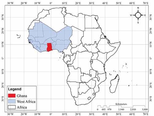
Figure 2. Mean monthly daily rainfall distribution at a) Kumasi (south) and b) Tamale (north) from March to February (water year) showing bi-modal and uni-modal distribution of rainfall, typical in southern and northern Ghana, respectively. (Source: drawn using data from Ghana Meteorological Service). See map, for station locations
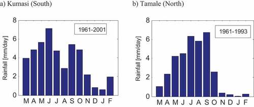
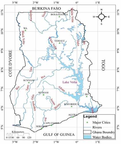
Figure 3. Map of Ghana showing major rivers and water bodies in Ghana
In Ghana and West Africa as a whole, the climate is influenced principally by the movement of three air masses which are the tropical maritime (monsoon), tropical continental (harmattan) and equatorial air masses (Ahenkorah et al., Citation1994; Boateng, Citation1966; Dickson & Benneh, Citation1988; Walker, Citation1962). The tropical maritime (monsoon) air mass takes its source from the South Atlantic Ocean. It is heavily laden with moisture due to its long movement over the ocean. The tropical continental air mass (harmattan) originates from the Sahara-Arabian desert and it is characterised by high temperatures and low relative humidity as a result of its long journey over the desert. The equatorial air mass has an uncertain origin, but it is restricted to the equatorial regions (Ahenkorah et al., Citation1994; Walker, Citation1962). The northwards and southwards movement of the Inter Tropical Convergence Zone (ITCZ), which is the converging zone of the monsoon and the harmattan air masses control the weather pattern of Ghana and West Africa as a whole. The country experiences two distinct seasonal rainfall distributions, i.e. the bi-modal distribution for the south and the uni-modal distribution for the north ()
Generally, the physical relief of Ghana is low (i.e. up to about 450 m above sea level) with topography which is predominantly undulating except the Akwapim-Togo mountain ranges which is located in the eastern part of the country. Mount Afadjato which is the highest altitude of the country (i.e. 880 m above sea level) is situated within this area. The relief of the country has been categorized into five physiographic regions namely: coastal plain, forest dissected plateau, savanna high plains, Voltain sandstone basin and the ridges and escarpment bordering the Voltain sandstone basin (Dickson & Benneh, Citation1988).
The geology of Ghana is made up of several rock formations. The largest formation underlain the country is the Voltain system which covers about 45 percent of the surface area, extending from the lower mid-section of the country up to the north. The Voltain system is compact and cemented with little or no porosity (Bates, Citation1962b; FAO, Citation2005b). It is mainly made up of sandstone, shale, mudstones, and limestone
(Bates, Citation1962a; Boateng, Citation1966; Dickson & Benneh, Citation1988). The major rivers in Ghana flow southwards and empty into the Gulf of Guinea (). Nearly 75 percent of the country is drained by River Volta, which basin covers parts of the neighbouring countries; of which 42 percent lies in Ghana, 43 percent in Burkina Faso and the remaining 15 percent in Mali, Ivory Coast, Togo and Benin (Van de Giessen et al., Citation2001).
3. Existing climatic and hydrological studies in Ghana
This section of the paper presents an overview of the existing climatic and hydrological studies in Ghana. This review of the local knowledge gives the starting point for further climatic and hydrological studies in Ghana
3.1. Climatic studies in Ghana
The climate of Ghana has been studied by numerous researchers. For instance, the causes of the rainfall anomaly along the coast of Ghana have been examined by Acheampong (Citation1982). He attributes the anomaly to meteorological effects within the rainy season, namely the South Atlantic high, which causes fluctuation in the thickness of the monsoon, resulting in low or no rain. Along the coast of Ghana and Ivory Coast, Koranteng and Pezennec (Citation1998) report reduced rainfall and increased wind speeds. They further point out that rainfall is less in coastal Ghana as compared to coastal Ivory Coast.
Within the Volta basin that drains about three-quarters of Ghana, Kunstmann and Jung (Citation2005) found a statistically significant increasing trend of temperature using ECHAM4 Global Circulation Model (GCM) simulations. Kunstmann and Jung (Citation2005) also found a slight increase in annual precipitation of about 5 percent and a significance decrease of rainfall in April (up to about 70 percent), which marks the transition from dry to rainy season.
Competition for water resources within the Volta basin has been studied by Van De Giessen et al. (Citation2001). They reported of high inter-annual variation of riverflow as compared to rainfall and high sensitivity of riverflow to rainfall. The Akosombo Dam which is the main source of electric power to the country has been experiencing low levels as a result of climatic changes. Gyau-Boakye (Citation2001) has discussed these changes and their causes. He points out that, the declining lake levels are due to declining riverflows from the catchment of River Volta as a result of rising temperatures and reduction of rainfall, principally, in the headwater catchments north of Ghana.
Using time-series analysis, Koranteng and Mcglade (Citation2001) have analysed Sea Surface Temperature (SST) data from near Ghana and Ivory Coast. They reported that the decomposed trend of the observed period (i.e. 1963–1992) could be divided into three climatic periods: the period before 1972, from 1972 to 1982 and the period after 1982. Within the first period SST were relatively high. The second climatic period was characterised by low temperatures and in the third period rising SST was observed. They concluded that the changes in the SST might influence the dynamics of fishery resources since the abundance and distribution of certain species coincided with particular climatic periods.
Numerous droughts have affected Ghana among which are the 1975–1977 and 1983 droughts (McSweeney et al., Citation2010) which have raised concern about water resources management in the country. Ofori-Sarpong (Citation1982) studied the nature and causes of the 1975–1977 droughts. The study found that the north-eastern part of the country was the most severely affected area, resulting in famine in 1977. The drought was attributed to climatic fluctuations and disturbances of the natural ecological balance by man. Further assessment of the distribution of annual rainfall and water budgets in the North-Eastern Ghana (i.e. Upper East Region) during the 1975–1977 droughts has been presented by Ofori-Sarpong (Citation1985). The study revealed wide fluctuations in the annual and seasonal rainfalls and susceptibility of the area to droughts. Generally, declining rainfall in the interior savannah zone has culminated in shorter agricultural seasons (Kranjac-Berisavljevic, Citation1999).
Attempts have also been made in the development of simulation models for the prediction of weather. For example, the investigation of within season variability of rainfall together with the estimation of average dry-spell durations and the development of simulation models for the prediction of rainfall patterns and amount at Accra and Tamale have been reported by Adiku et al. (Citation1997). They observed that in Accra (South) the average duration of dry spells in the rainy season fluctuated from 7 days in March to 2 days in June and 5 days in July, while in Tamale (North) it was about 3 days. They pointed out that the regular pattern at Tamale suggests that rainfed agriculture is more likely to be successful in Tamale than Accra. Predicting rainfall using the Southern Oscillation Index (SOI) has been discussed by Adiku and Stone (Citation1995). They found that direct correlation of SOI and rainfall did not yield a very strong relationship. However, the lagged relationship and the SOI-phase system could be used as a means of predicting rainfall in Ghana. Examination of possible relationship between rainfall in Ghana and Atlantic SSTs has been reported by Opoku-Ankomah and Cordery (Citation1994). They found significant correlation between SST and monthly rainfall with lags, which offers the possibility of up to two-month forecast of rainfall in advance in the country.
The climate of Ghana has also been studied by African Monsoon Multiplicity Analysis (AMMA) project, which is an international project covering the whole of the West Africa sub-region, with the goal of improving the knowledge of the West African monsoon and its variability and impacts on the environment, including water resources, health and food security (Giles, Citation2006; Lebel et al., Citation2005; Redelsperger et al., Citation2006). In 2012, with funding from German Federal Ministry of Education and Research (BMBF) the West African Science Service Centre on Climate Change and Adapted Land Use (WASCAL) was formed by pooling the expertise of ten West African countries including Ghana and Germany together (WASCAL Cooperation Agreement Document, Citation2012). The main objective of WASCAL is to strengthen the research infrastructure and capacity in West Africa related to climate change. Since then WASCAL has carried out numerous research on climate change and its impacts on the environment and improving human livelihoods which can be found on their website (www.wascal.org). With support from USAID, Ghana’s climate change, vulnerability and adaptation have been assessed by Stanturf. et al. (Citation2011).
The understanding of rainfall patterns in the country is very crucial and due to that numerous studies on the analysis of rainfall distribution and variation in the country have been recently carried out. These include: rainfall cessation and length of rainy days (Amekudzi. et al., Citation2015), trends in Spatio-temporal rainfall variability in Ghana (Owusu & Waylen, Citation2009), the simulation of the rainfall regime over Ghana from CORDEX by Owusu and Klutse (Citation2013), rainfall and temperature changes and variability in the Upper East Region of Ghana (Issahaku et al., Citation2016), rainfall distribution in the Upper East region of Ghana (Ampadu et al., Citation2019), analysis of rainfall variability in Ghana (Logah et al., Citation2013), rainfall variability over Ghana: model versus gauge observation (Nkrumah et al., Citation2014), climate change and variability in Ghana: stocktaking (Asante & Amuakwa-Mensah, Citation2015) and drying climate of the country from 1960 to 2005 (Lacombe et al., Citation2012).
Cycles in the rainfall across the Ghanaian latitudinal gradient have been studied by (Ampadu, Citation2007). From spatial analysis of the cycles in the rainfall the study found out that stations only a few tens of kilometres apart, have different inter-annual dynamics. Similarly, Abbam et al. (Citation2018) in their study of the spatio-temporal variations in rainfall and temperature in the country over the twentieth century from 1900 to 2014 established that the pattern of changes in rainfall and temperature is spatially heterogeneous and recommended a large-scale adaptation policy to mitigate these effects.
Kasei et al. (Citation2014a) and (Citation2014b) report of climate downscaling over Densu Basin and nexus on the hydrology of Ghana and the changing climate and impacts on rainfed water supply and fresh water availability for the basin. Recent climate trends and the use of CCLM and RCA regional climate models to simulate the climate characteristics and extremes of the Volta Basin have been reported by Darko et al. (Citation2019a, Citation2019b). GCM projections of future climate of Ghana have been presented by McSweeney et al. (Citation2010). Their study found a projected rapid warming in the northern inland regions as compared to the coastal areas.
3.2. Hydrological studies in Ghana
The hydrology of Ghana has been studied both in the field and by modelling, but primary by modelling techniques. One of the most important hydrological projects in the country has been the development of a Decision Support System (DSS) for the Volta Basin by Global Change in the Hydrologic Cycle (GLOWA) project (Berger et al., Citation2002; Van de Giesen et al., Citation2002, Citation2001; Van Edig et al., Citation2003). This project was involved in the development of a decision-making tool for the sustainable management of water in the Volta basin.
The hydrology of Ghana is characterised by extreme drought with marked deficit of soil-water and riverflow during the dry season and excess soil-water and riverflow during the wet season (Acheampong, Citation1988). This feature of the Ghanaian hydrology is due to seasonal rainfall falling on an undulating landscape, with large tracts of low-lying land being very well drained (Acheampong, Citation1988). Generally, in the Southwest of Ghana, where rainfall is heavy and last longer there is high water surplus while in the North, where there is low rainfall and high potential evaporation, water deficit is high (Acheampong, Citation1988).
Other more localised hydrological studies include Nyarko (Citation2002), who used the Rational Model in a GIS framework to zone flood risk areas in Accra. The results of the study showed that the high flood risk zone covers 35.66 percent of Accra while the low-risk zone covers 26.85 percent and the areas likely to experience periodic floods with a given input of rainfall are mostly below 350 m contour. Turner et al. (Citation1996) investigated the hydrology of Lake Bosumtwi, a crater lake in the Ashanti region. They developed an empirical water balance model for the lake by using the lake-level records of 60 years. The study revealed that rainfall rather than temperature largely controls the year-to-year changes in the lake levels. Besides this study, the hydrology of the major sources of water to the Lake has been reported by Amu-Mensah et al. (Citation2019).
The development of a regression model for the assessment of the riverflow resources of the South-Western and Coastal basin systems has been reported by Opoku-Ankomah and Forson (Citation1998). Their model explained 90 percent and 70 percent of the variance in the observed flows, respectively. In the South-Western river basin Opoku-Ankomah and Amisigo (Citation1998) found a reduction in the mean rainfall and discharge from 1951 to 1970 to a lower mean from 1971 to 1991. In addition, they also found that a decrease in the riverflow was higher than that of the rainfall. For the same period of 1951–1970 and 1971–1990, Gyau-Boakye and Tumbulto (Citation2000) studied the rainfall and riverflow pattern of the Oti and the White Volta basins. They reported of a reduction in mean streamflow of 32.5 percent at Saboba on the Oti River and 23.1 percent at Nawuni on the White Volta River between the two time periods. Bekoe (Citation2005), reports of the successful modelling of flows of River Densu by the application of the Agricultural Catchment Research Unit (ACRU) model. Troch et al. (Citation2007) report of a water balance study in the Volta basin, also the relationship between rainfall and runoff on the White Volta Basin at Pwalugu has been presented by Kasei et al. (Citation2013).
Modelling of rainfall and riverflow using Data based Mechanistic (DBM) modelling approach in the Volta Basin and the River Pra Basin have been reported by Amisigo (Citation2005), Ampadu (Citation2007), Citation(2013a), and (Citation2015), respectively. Climate change and its impacts on water resources have been reported by Ofori et al. (Citation2016). The study found out that with increasing water demand due to an increase in population coupled with climate change and variability, sectors in the economy that depend mostly on water resources are going to be affected. The impacts of climate change on streamflows have also been reported by Obuobie et al. (Citation2012) and Kankam-Yeboah et al. (Citation2013). Within the Volta basin and other river systems, Amisigo et al. (Citation2015) reports on the modelling of climate change impacts on agricultural water demand. A review of water resources of the country on the management and the future prospect (Owusu et al., Citation2016) and that of the quality and management of freshwater resources (Yeleliere et al., Citation2018) have been reported.
Recently, Guug et al. (Citation2020) applied the SWAT hydrological model to assess water availability at the Sherigu catchment of Ghana and Southern Bukina Faso with a satisfactory model performance of Nash and Sutcliffe efficiency greater than 70 percent. The model revealed that a whopping 72 percent of the total annual precipitation is consumed by evapotranspiration. Soil-water balance of an agricultural watershed in the Guinea Savannah Agro-ecological Zone of the Tono watershed in the Upper East region of Ghana has also been modelled using the SWAT model by Ampofo et al. (Citation2020). The study indicates a decrease of 17.6 percent, 9.6 percent, and 1.6 percent in rainfall, soil moisture and evapotranspiration respectively from 1984 to 2014.
4. Declining rainfall and riverflows in Africa vis-à-vis Ghana
Weston and Steven (Citation2005) report that water scarcity in the African continent is expected to increase drastically by the end of 2025, with climate being the main factor. In recent decades, within West Africa, declining rainfall has been observed by numerous studies (Hulme, Citation1992; LeBarbe et al., Citation2002; Nicholson et al., Citation2018, Citation2000; Ojo, Citation1987; Ojo et al., Citation2004; Paturel et al., Citation1997) together with reduction in riverflows (Gyau-Boakye & Tumbulto, Citation2000; Mahe et al., Citation2013; Niasse et al., Citation2004; Ojo et al., Citation2004). Notably among them is the significant reduction of annual rainfall in the Sahel region of about 15 to 40 percent from 1931 to 1960 and 1968 to 1997 reported by Nicholson et al. (Citation2000) and a massive decline of flows of about 60 percent of the River Senegal and River Gambia from 1971 to 1989 as compared to the period of 1951–1970 (Niasse et al., Citation2004).
The declining rainfall and riverflows have not only serious economic implications but also profound environmental effects. For example, the destruction of forest by bush fires during drought conditions (Ahenkorah et al., Citation1994; Bagamsah, Citation2005) and water quality problems in times of river low flow (Antonopoulus et al., Citation2001; Frederick, Citation1993).
There is, therefore, the need to investigate the West African rainfall behaviour and effects on riverflows, of which Ghana is a representative region, because of its central location () and coverage of the principal hydro-climatic zones (Ojo et al., Citation2004). This calls for the modelling of the historical records of rainfall and riverflow, to identify cycles and trends within the data, in order to study the temporal and spatial variability within the records. If we can quantify the separate components of the rainfall and riverflow cycles and trends, then we might be able to a) assist in understanding the physical causes (climatic or anthropogenic phenomena), and b) facilitate better forecasts of changing rainfall and riverflow resources. This is of great interest and importance in the formulation of policies and development of strategies which will lead to efficient utilisation of water resources for consumption, agriculture, hydropower generation and environmental protection.
Understanding the dynamic link between rainfall and riverflow response can give greater understanding of rainfall-riverflow processes through hydrologic interpretation of the Dynamic Response Characteristics (DRCs) within models (Young, Citation1992; Young & Beven, Citation1994; Young et al., Citation1997; Chappell et al., Citation1999; Sefton & Howarth, Citation1998: Ampadu et al., Citation2013a, 2015) with its limited data on distributed catchment characteristics (e.g. soil properties and hydro-geology). This will also give improved forecasts of riverflow from rainfall data, which would greatly enhance the government’s planning of water supply provision within the basins in the African region and Ghana in particular.
4.1. Rainfall-riverflow modelling and limited data in Africa and Ghana in particular
Rainfall-riverflow modelling provides the means, for the investigation of the interaction between climate and riverflow. This requires the use of extensive historical records which are generally, lacking in Africa. According to Weston and Steven (Citation2005) and Giles (Citation2005) the number of weather stations in Africa is eight times below the minimum level recommended by the World Meteorological Organisation (WMO).
In West Africa, the dearth of meteorological data is very common, as pointed out by Van de Giesen et al. (Citation2002). In Ghana, the situation is not far different from other African countries; hydrological and meteorological data of the country are inadequate and of poor quality, with the exception of a few stations (Adiku et al., Citation1997; Ampofo et al., Citation2020). Generally, rainfall and riverflow stations in the tropics are of low density and in some areas of interest; the requisite data is simply not available (Douglas, Citation1999). Some of the recording instruments are no more in existence, while the existing ones are deteriorating, especially, in Africa and the northern part of Ghana in particular.
This calls for the use of models that can handle time-series records with many gaps or missing data, and quantify the effects of sometimes poor data quality on model structures and parameters to be interpreted (Chappell et al., Citation2006; Young, Citation2001; Young et al., Citation1999). One of such approaches is the relatively new Data-Based Mechanistic (DBM) modelling routines (Beck & Young, Citation1975; Whitehead & Young, Citation1975; Young, Citation1978, Citation1983, Citation1984, Citation1986, Citation1992, Citation1993; Young & Minchin, Citation1991; Young & Lees, Citation1993; Young & Beven, Citation1994; Chappell et al., Citation1999; Lees, Citation2000; Amisigo, Citation2005; Ampadu et al., Citation2013a, 2015).
4.2. Problems with rainfall-riverflow modelling using limited data and the call for DBM approach in Africa
Riverflow simulation routines have been classified in numerous ways (Ampadu et al., Citation2013b; Beck, Citation1991; Chappell, Citation2005; Clarke, Citation1973; Freeze & Harlan, Citation1969; Leavesley, Citation1994; Legesse et al., Citation2003; Refsgaard, Citation1996; Wheater et al., Citation1993). A classical example is the physics-based, distributed models, which emanates from the solution of physics-based equations, based on the lumping over grids usually of dimensions between 100 × 100 m and 1000 × 1000 m in surface area (Wheater et al., Citation1993).
Catchment properties lumped over these scales do not realistically represent the larger scale say 100–50,000 km2 variability. This is because hydrological systems are inherently nonlinear (Young & Beven, Citation1994; Chappell et al., Citation2004a, Citation2006; Ampadu et al., Citation2013a, 2015), because of the nature of certain catchment characteristics such as the presence of varying sub-surface soil moisture. These models also require 100s or 1000s of model parameters to be optimised (e.g. see: K. Beven, Citation1989), unlike the few parameters required by the DBM routines (Chappell et al., Citation1999, Citation2006; Lees, Citation2000; Young & Beven, Citation1994; Young et al., Citation1997). Typical examples of physics-based distributed models include Système Hydrologic Européen (SHE) (Abbot et al., Citation1986a, 1986b), Institute of Hydrology Distributed Model (IHDM) (Beven et al., Citation1987; Calver & Wood, Citation1995), and the MIKE SHE (Refsgaard & Storm, Citation1995; Refsgaard et al., Citation1999).
The major negative impact of having complex model structures with huge numbers of parameters to be defined by model calibration is the consequent uncertainty in the value of each parameter identified. If we are to interpret the value of each parameter (e.g. permeability and residence time), the uncertainty must be small, thus the number of parameters must be constrained. Conceptual models, e.g. NAM (Refsgaard et al., Citation1995) tend to use fewer parameters in comparison to physics-based distributed models (Abbot et al., Citation1986a; K. Beven, Citation1989; Refsgaard & Storm, Citation1995; Refsgaard et al., Citation1999); however, some of the most simple model structures that still describe hydrological response are Data-Based Mechanistic (DBM) models (Chappell et al., Citation1999, Citation2006, Citation2004a; Tsang, Citation1995; Young, Citation1998, Citation2002, Citation2003, Citation2005; Young & Beven, Citation1994; Young et al., Citation1997). This efficient simplicity and “parsimony” (Chappell et al., Citation1999, Citation2004b; Ampadu et al., Citation2013a, Citation2013b, 2015) results from the three-stage process of the DBM approach. These three stages
are:
Extraction of information from the rainfall and riverflow records by fitting models to the data.
Identification of a range of models and their associated hydrological system parameters using objective statistical tests.
Selection of the model with the most plausible physical explanation of the data.
The DBM routines used within the three-stage DBM approach, namely Dynamic Harmonic Regression (DHR) and Transfer Function (TF) are capable of extracting climatic and riverflow cycles and trend and characterising the uncertainty of the cycles and trend for subsequent identification of land use impacts (Chappell et al., Citation2001, Citation2004a) and quantifying the dynamics of rainfall to riverflow process (Young & Beven, Citation1994; Young et al., Citation1997; Young, Citation2001; Vongtanaboon & Chappell, Citation2004; Vongtanaboon, Citation2004; Chappell et al., Citation2006; Ampadu et al., Citation2013a, Citation2013b, 2015). The approach unlike the traditional modelling approaches which fit data to predefined model structures is based on the concept whereby the data is allowed to suggest the type of model structure compatible to the input and output data in a stochastic manner. The mechanistic nature of the approach allows the physical interpretation of the resulting model (e.g. number of dominant water pathways).
The technique has been applied successfully in humid temperate conditions (Beven, Citation2001; Young, Citation1998, Citation2001; Young & Beven, Citation1994; Young et al., Citation1997) and in tropical conditions in South-East Asia (Chappell et al., Citation2004b, Citation2001, Citation1999, Citation2006, Citation2004a; Solera-Garcia, Citation2009; Solera-Garcia et al., Citation2006; Vongtanaboon & Chappell, Citation2004). The DBM three-stage approach has also been applied successfully in East Africa in the semi-arid environment of Tanzania by Mwakalila et al. (Citation2001) and in a forest area in the same country by Vigiak et al. (Citation2006) and in Ghana, semi-arid area in the north (Volta Basin) by Amisigo (Citation2005) and in the forest area (River Pra Basin) in the south by Ampadu (Citation2007) and Ampadu et al. (Citation2013a, 2015). The “parsimonious” nature of the DBM routines, the handling of missing data and explicit estimation of uncertainty in the simulation, make them very appropriate for modelling and interpreting rainfall and riverflow time series from Africa and Ghana in particular, where data quality is sometimes poor.
5. Value of filling the knowledge gaps within the past hydrological and climatic studies in Ghana
The above studies (Sections 3.1 and 3.2) point to the efforts of researchers in climatic and hydrological studies in Ghana. This leads to the knowledge gap of innovative ways of further understanding of rainfall-riverflow processes and their controls in the country which future studies should consider. Furthermore, estimation of cycles in evapo-transpiration time series and riverflows should also be considered together with the complete characterisation of the temporal and spatial fluctuations within the climate cycles including solar radiation because of its impacts on evaporation and for that matter water availability in the country. This is very important because it will provide a clear understanding of the rainfall-riverflow behaviour throughout the seasons over the years, across the Ghanaian latitudinal gradient. This is very crucial to agriculture and the planning of water supply provision within the country. As mentioned by McGranahan (Citation2002), the reliance on mean annual riverflow for agricultural planning could be very misleading, since floods in one period do not compensate for low flows in another. In this regard, the study of rainfall and riverflow behaviour of Ghana, in order to understand how rainfall regulates the riverflow hydrology and runoff generation processes (Ward & Robinson, Citation1990; Shaw et al., Citation2011) is very crucial and cannot be overemphasised.
The transformation of rainfall to riverflow or runoff is a nonlinear process due to antecedent moisture conditions and the changing surface moisture (FAO, Citation1981; Young & Beven, Citation1994; Amisigo, Citation2005; Ampadu, Citation2007; Ampadu et al, 2013). Thus, the wetter the catchment prior to a unit input of rainfall, the greater the volume of runoff that will be generated (Beven, Citation2001). In semi-arid areas such as the northern part of Ghana, nonlinearity is high due to transmission losses as a result of infiltration into a dry channel bed. This becomes very high as the catchment area increases (Beven, Citation2001). In respect of this, hydrological studies in the country especially in rainfall-riverflow modelling processes, the nonlinear behaviour or non-stationarity of the catchments should be of great concern as considered by Amisigo (Citation2005) in the Volta basin and Ampadu (Citation2007) and Ampadu et al. (Citation2013a, 2015) in the River Pra basin. This is very important because the catchment characteristics keep on changing due to land use and land cover change which are related to deforestation, urbanisation, bush fires, climate change, socio-economic activities and ecosystem dynamics (Pechlivanidis et al., Citation2011). This may aggravate non-linear behaviour of the catchments thereby affecting their hydrologic response.
6. Concluding remarks
Hydrological and meteorological data of Ghana are of poor quality and inadequate, with the exception of a few stations. The rainfall and riverflow stations are of low density and in some areas data is simply not available, especially in the northern part of the country. Some of the recording instruments are no more in existence whilst the existing ones are very weak and deteriorating. This calls for the use of models capable of handling such data in studying the climate and hydrology of Ghana or Africa as a whole. One such modelling approach is the Data-based Mechanistic (DBM) modelling approach, which has been discussed above in this review. The approach is parsimonious, in that it requires little internal catchment characterisation. It is, therefore, particularly suited to a data limited region like West Africa and Ghana in particular. Furthermore, DBM Transfer Function rainfall to riverflow modelling within all the catchments in Ghana and if possible tropical catchments are recommended so that a monograph of catchment characteristics including nonlinearity and dynamic response characteristics could be established. Such monograph could help in the prediction of hydrologic response of ungauged catchments in the tropics and Ghana in particular which is the goal of the International Association of Hydrological Sciences (IAHS) Predictions in Ungauged Basins (PUB) initiative (Pechlivanidis et al., Citation2011; Troch et al., Citation2007).
To better model riverflow cycles, estimation of cycles in evapo-transpiration time series should also be considered together with the complete characterisation of the temporal and spatial fluctuations within the climate cycles and that of the riverflows across the West African sub-region. This will help in the identification of changes in the rainfall and riverflow regime which is very crucial for water resources projects planning and management across the region.
There is also the need for a modelling technique such as the DBM approach which is capable of analysing environmental systems, and coupled with other techniques, may give a greater insight and complete understanding of the hydrological, climatic and environmental systems and the link between rainfall and riverflow response of the West African sub-region, Ghana in particular and Africa as a whole.
Additional information
Funding
Notes on contributors

Boateng Ampadu
Boateng Ampadu is an Associate Professor at the Department of Environmental Science, Faculty of Earth and Environmental Sciences, C. K. Tedam University of Technology and Applied Sciences (CKT-UTAS), Navrongo, Ghana. He graduated with BSc (Agricultural Engineering), MSc (Water Resources Engineering), and PhD (Environmental Science) from KNUST, Ghana, University of Dar es Salaam, Tanzania, and University of Lancaster, UK, respectively, and is also a member of Ghana Institution of Engineers and Ghana Science Association. He teaches Environmental Modeling, Hydrological Processes, Catchment Hydrology, Environmental Physics and Climate Change Studies, among others. His research interest is in climate variability and hydrological impact; hydrological modelling; estimation of trend and cycles in long-term environmental data; rainfall distribution and variability analysis among others. He has attended many workshops, short courses, and conferences and has over thirty-five (35) publications in local and international peer reviewed journals to his credit.
References
- Abbam, T., Johnson, F. A., Dash, J., & Padmadas, S. S. (2018). Spatiotemporal variations in rainfall and temperature in Ghana over the twentieth century, 1900–2014. Earth and Space Science, 5(4), 120–17. https://doi.org/10.1002/2017EA000327
- Abbot, M. B., Bathurst, J. C., Cunge, J. A., O’Connell, P. E., & Rasmussen, J. (1986a). An introduction to the European hydrological system-systeme hydrologique European “SHE”, 1: History and philosophy of a physically-based distributed modelling system. Journal of Hydrology, 87(1–2), 45–59. https://doi.org/10.1016/0022-1694(86)90114-9
- Abbot, M. B., Bathurst, J. C., Cunge, J. A., O’Connell, P. E., & Rasmussen, J. (1986b). An introduction to the European hydrological system-systeme hydrologique european “SHE”, 2: Structure of a physically-based distributed modelling system. Journal of Hydrology, 87(1–2), 61–77. https://doi.org/10.1016/0022-1694(86)90115-0
- Acheampong, P. K. (1982). Rainfall anomaly along the coast of Ghana-Its nature and causes. Geographical Annaler, 64A(3–4), 199–211.
- Acheampong, P. K. (1988). Water balance analysis for Ghana. Geography, 73(2), 125–131.
- Adiku, S. G. K., Dayananda, P. W. A., Rose, C. W., & Dowuona, G. N. N. (1997). An analysis of the within-season rainfall characteristics and simulation of the daily rainfall in two savannah zones in Ghana. Agricultural and Forest Meteorology, 86(1–2), 51–62. https://doi.org/10.1016/S0168-1923(96)02414-8
- Adiku, S. G. K., & Stone, R. C. (1995). Using the Southern oscillation index for improving rainfall prediction and agricultural water management in Ghana. Agricultural Water Management, 29(1), 85–100. https://doi.org/10.1016/0378-3774(95)01181-1
- Adomako, T., & Ampadu, B. (2015). The impact of agricultural practices on environmental sustainability in Ghana: A review. Journal of Sustainable Development, 8(8), 71–85. https://doi.org/10.5539/jsd.v8n8p70
- Ahenkorah, Y., Amatekpor, J. K., Dowuona, G. N. N., & Yentumi, S. D. (1994). Soil and water resources of Ghana: Their conservation, management and constraints to their utilization for sustainable development (pp. 131). United Nations University/Institute of natural Resources for Africa.
- Aka, A. A., Servat, E., Paturel, J. E., & Koume, B. (1996). Analysis of the temporal variability of runoff in ivory coast: Statistical approach and phenomena characterisation. Hydrological Sciences Journal, 41(6), 959–970. https://doi.org/10.1080/02626669609491561
- Almer, C., Laurent-Lucchetti, J., & Oechslin, M. (2017). Water scarcity and rioting: Disaggregated evidence from Sub-Saharan Africa. Journal of Environmental Economics and Management, 86, 193–209. https://doi.org/10.1016/j.jeem.2017.06.002
- Amekudzi., L. K., Yamba, E. I., Preko, K., Asare, E. O., Aryee, J., Baidu, M., & Codjoe, S. N. A. (2015). Variabilities in rainfall onset, cessation and length of rainy season for the various agro-ecological zones of Ghana. Climate, 3(2), 416–434. https://doi.org/10.3390/cli3020416
- Amisigo, A. A. (2005). Modelling riverflow in the volta basin of West Africa: A data-driven framework (Ecology and Development Series, No. 34), pp 175. Cuvillier Verlag
- Amisigo, B. A., McCluskey, A., & Swanson, R. (2015). Modeling impact of climate change on water resources and agriculture demand in the volta basin and other basin systems in Ghana. Sustainability, 7(6), 6957–6975. https://doi.org/10.3390/su7066957
- Ampadu, B. (2007). Simulating rainfall and riverflow dynamics in Ghana [An Unpublished PhD Thesis]. Lancaster University.
- Ampadu, B., Chappell, N. A., & Kasei, R. A. (2013b). Rainfall-riverflow modelling approaches: Making a choice of Data-based Mechanistic (DBM) modelling approach for data limited catchments: A review. Canadian Journal of Pure and Applied Sciences, 7(3), 2571–2580.
- Ampadu, B., Chappell, N. A., & Tych, W. (2013a). Data-based mechanistic modelling of rainfall to riverflow of large nested tropical rainforest catchments in Ghana. Canadian Journal of Pure and Applied Sciences, 7(2), 2195–2201.
- Ampadu, B., Chappell, N. A. and Tych, W. (2015). Data Based Mechanistic modelling optimal utilisation of raingauge data for rainfall-riverflow modelling of sparsely gauged tropical basin in Ghana. Journal of Mathematical Theory and Modelling,5(8), 29–49.
- Ampadu, B., Sackey, I., & Cudjoe, E. (2019). Rainfall distribution in the Upper East Region of Ghana, 1976 – 2016. Ghana Journal of Science, Technology and Development, 6(2), 45–59. https://doi.org/10.47881/168.967x
- Ampofo, S., Ampadu, B., Biyogue, D. N., & Kusibu, M. M. (2020). Modeling soil water balance of an agricultural watershed in the Guinea Savannah Agro-ecological Zone; a case of the Tono irrigation dam watershed. Ghana Journal of Science, Technology and Development, 7(1), 69–81. https://doi.org/10.47881/223.967x
- Amu-Mensah, F. K., Amu-Mensah, M. A., Akrong, M. O., Darko, H., & Addico, G. (2019). Hydrology of the major water sources of Lake Bosomtwe in Ghana. West African Journal of Applied Ecology, (WAJAE), 27(1), 42–51.
- Ankomah, Y. O., & Forson, M. A. (1998). Assessing surface water resources of the south-western and coastal basin systems of Ghana. Hydrological Sciences Journal, 43(5), 733–740. https://doi.org/10.1080/02626669809492169
- Antonopoulus, V. Z., Papamichail, D. M., & Mitsiou, K. A. (2001). Statistical and trend analysis of water quality and quantity data for the Strymon River in Greece. Hydrology and Earth Systems Sciences, 5(4), 679–691. https://doi.org/10.5194/hess-5-679-2001
- Asante, F. A., & Amuakwa-Mensah, F. (2015). Climate change and variability in Ghana: Stocktaking. Climate, 3(1), 78–101. https://doi.org/10.3390/clic3010078
- Baah-Wiredu, K. (2006). The budget statement and economic policy of the Government of Ghana for the 2007 financial year (pp. 462). Ghana of Ghana (GoG).
- Bagamsah, T. T. (2005). The impact of bushfire on carbon and nutrient stacks as well as albedo in the savanna of northern Ghana (Ecology and Development Series No. 25), pp 156. Cuvillier Verlag.
- Bates, D. A. (1962a). Geology. In J. B. Willis (Ed.), Agricultural and land use in Ghana (pp. 51–61). Oxford University Press.
- Bates, D. A. (1962b). Rural water supplies. In J. B. Willis (Ed.), Agricultural and land use in Ghana (pp. 62–76). Oxford University Press.
- Beck, M. B. (1991). Forecasting environmental change. Journal of Forecasting, 10(1–2), 3–19. https://doi.org/10.1002/for.3980100103
- Beck, M. B., & Young, P. C. (1975). A dynamic model for DO-BOD relationships in a non-tidal stream. Water Resources Research, 9(9), 769–776. https://doi.org/10.1016/0043-1354(75)90028-7
- Bekoe, E. O. (2005). Application of a hydrological model in a data-poor tropical West African catchment: A case study of the densu basin of Ghana. Institute of water and environment [Unpublished PhD Thesis]. Cranfield University at Silsoe, 228.
- Berger, T., Park, S., Vescori, F., Vlek, P. L. G., & van de Giessen, N. (2002). Sustainable water use under changing land use, rainfall reliability and water demands in the Volta basin (Glowa Volta). IHDP Newsletter, 6, 14–15.
- Beven, K. (1989). Changing ideas in hydrology - The case of physically-based models. Journal of Hydrology, 105(4), 157–172. https://doi.org/10.1016/0022-1694(89)90101-7
- Beven, K., Calver, A., & Morris, E. M. (1987). The institute of hydrology distributed model. (Institute of Hydrology Report, 98).
- Beven, K. J. (2001). Rainfall-runoff modelling: The primer (pp. 360). Wiley.
- Biney, C. A. (2012). Integrated water resources management for sustainable use: The case of the volta basin in West Africa. FAO Nature and Faune, 27(1), 19–21.
- Boafo, J. (2013). The impact of deforestation on forest livelihoods in Ghana. Backgrounder, 49, 1–7.
- Boateng, E. A. (1966). A geography of Ghana (2nd ed., pp. 212). Cambridge University Press.
- Bruijnzeel, L. A. (1990). Hydrology of moist tropical forests and effects of conversion: A state of knowledge review (pp. 224). UNESCO.
- Calver, A. & Wood, W. L. (1995). The Institute of Hydrology Distributed Model. In: V. P, Singh (Ed.), Computer models of watershed hydrology.Highlands Ranch: Water Resources Publications,595–626.
- Chappell, N. A., Tych, W., Yusop, Z., Rahim, N. A., & Kasran, B. (2004a). Spatial significant effects of selective tropical forestry on water, nutrient and sediment flows: A modelling supported review. In M. Bonell & L. A. Brujinzeel (Eds.), Forest, water and people in the humid tropics (pp. 513–533).
- Chappell, N. A., Bidin, K., Sherlock, M. D., & Lancaster, J. W. (2004b). Parsimonious spatial representation of tropical soils within dynamic rainfall- runoff models. In M. Bonell & L. A. Brujinzeel (Eds.), Forest, water and people in the humid tropics (pp. 756–769).
- Chappell, N. A. (2005). Modelling tropical forest watersheds: Setting realistic goals. ETFRN News, 45, 25–28.
- Chappell, N. A., Sherlock, M., Bidin, K., Macdonald, R., Najman, Y., & Bidin, K. (2007). Runoff processes in South East Asia: Role of soil, regolith and rock type. In H. Sawada, M. Araki, N. A. Chappell, J. V. LaFrankie, & A. Shimizu (Eds.), Forest environments in the Mekong River Basin (pp. 3–23). Springer Velag.
- Chappell, N. A., Bidin, K., & Tych, W. (2001). Modelling rainfall and canopy controls on net precipitation beneath selective-logged tropical forest. Plant Ecology, 153(1/2), 215–229. https://doi.org/10.1023/A:1017532411978
- Chappell, N. A., & Bonell, M. (2005). Uncertainties in the hydrology of tropical reforestation: Beyond ‘ from the mountain to the tap’. ETFRN News, 45, 8–11.
- Chappell, N. A., Franks, S. W., & Larenus, J. (1998). Multi-scale permeability estimation for a tropical catchment. Hydrological Processes, 12(9), 1507–1523. https://doi.org/10.1002/(SICI)1099-1085(199807)12:9<1507::AID-HYP653>3.0.CO;2-J
- Chappell, N. A., McKenna, P., Bidin, K., Douglas, I., Walsh, A. R. P. D., Newbery, D. M., Clutton–Brock, T. H., & Prance, G. T. (1999). Parsimonious modelling of water and suspended sediment flux from nested catchments affected by selective tropical forestry. Philosophical Transactions of the Royal Society of London. Series B: Biological Sciences, 35(4), 1831–1846. https://doi.org/10.1098/rstb.1999.0525
- Chappell, N. A., Tych, W., Chotai, A., Bidin, K., Sinun, W., & Chiew, T. H. (2006). BARUMODEL: Combined data based mechanistic models of runoff response in a managed rainforest catchment. Forest Ecology and Management, 224(1–2), 58–80. https://doi.org/10.1016/j.foreco.2005.12.008
- Chipeta, M. E. (2012). If Africa is to develop its agriculture, should it follow the recommendations of the World Commission on Dams? FAO Nature and Faune, 27(1), 22–25.
- Chitonge, H. (2020). Urbanisation and the water challenge in Africa: Mapping out orders of water scarcity. African Studies, 79(2), 192–211. https://doi.org/10.1080/00020184.2020.1793662
- Clarke, R. T. (1973). A review of some mathematical models used in hydrology, with observations on their calibration and use. Journal of Hydrology, 19(1), 1–20. https://doi.org/10.1016/0022-1694(73)90089-9
- Cosgrove, W. J., & Rijsberman, F. R. (2000). Making water everybody’s business (pp. 108). Earth Scan Publications Ltd.
- Darko, D., Adjei, K. A., Appiah-Adjei, E. K., Odai, S. N., Obuobie, E., & Asmah, R. (2019b). Simulation of climate characteristics and extremes of the volta basin using CCLM and RCA regional climate models. Theoretical and Applied Climatology, 134(1–2), 741–763. https://doi.org/10.1007/s00704-018-2485-6
- Darko, D., Adjei, K. A., Odai, S. N., Obuobie, E., Asmah, R., & Trolle, D. (2019a). Recent climate trends for the volta basin in West Africa. Weather, 74 (S1), S13–S22. Royal Meteorological Society. https://doi.org/10.1002/wea.3303
- Dickson, K. B., & Benneh, G. (1988). A new geography of Ghana (pp. 170). Longman.
- Douglas, I., Bidin, K., Balamurugan, G., Chappell, N. A., Walsh, R. P. D., Greer, T., & Sinun, W. (1999). The role of extreme events in the impacts of selective tropical forestry on erosion during harvesting and recovery phases at Danum Valley, Sabah. Philosophical Transactions of the Royal Society London, B 354(1391), 1749–1761. https://doi.org/10.1098/rstb.1999.0518
- Douglas, I., Newbery, D. M., Clutton–Brock, T. H., & Prance, G. T. (1999). Hydrological investigations of forest disturbance and land cover impacts in South-East Asia: A review. Philosophical Transactions of the Royal Society B, 354, 1725–1738. https://doi.org/10.1098/rstb.1999.0516
- Douglas, I., Spencer, T., Greer, T., Bidin, K., Sinun, W., & Meng, W. M. (1992). The impact of selective commercial logging on stream hydrology, chemistry and sediment loads in the Ulu Segama rain forest, Sabah, Malaysia. Philosophical Transactions of the Royal Society London B, 335, 397–406.
- Environmental Protection Agency. (2010). National greenhouse gas inventory report for 1990 – 2006. (Vol. 1, pp 90). October 2011.
- Environmental Protection Agency. (2019, February). Ghana’s fourth national greenhouse gas inventory report. pp 318.
- FAO. (1981). Arid zone hydrology. FAO Irrigation and drainage paper, (vol. 37, p. 96).
- FAO. (2005a). Irrigation in Africa in figures-Aquastat survey. (FAO Water reports), pp 649.
- FAO. (2005b). Irrigation in Africa in figures-Aquastat survey (Country profile- Ghana) (FAO Water reports, 29), pp 89.
- Frederick, K. D. (1993). Balancing water demands with supplies: The role of management in a world of increasing scarcity. World Bank Technical Paper Number, 189, 72.
- Freeze, R. A., & Harlan, R. L. (1969). Blueprint for a physically-based, digitally- simulated hydrologic response model. Journal of Hydrology, 9(3), 237–258. https://doi.org/10.1016/0022-1694(69)90020-1
- Giles, J. (2005). Solving Africa’s Climate-data problem. Nature, 435, 863.
- Giles, J. (2006). Meteorologists pour into West Africa. Nature, 442(7102), 496. https://doi.org/10.1038/442496a
- GSS. (2013). Ghana statistical services, national accounts statistics for provisional gross domestic product, Accra, Ghana. http://www.stasghana.gov.gh
- Guug, S., Abdul-Ganiyu, S., & Kasei, R., . A. (2020). Application of SWAT hydrological model for assessing water availability at the Sherigu catchment of Ghana and Southern Burkina Faso. HydroResearch, 3, 124–133. https://doi.org/10.1016/j.hydres.2020.10.002
- Gyau-Boakye, P. (2001). Environmental impacts of the Akosombo dam and effects of climate change on the lake levels. Environment, Development and Sustainability, 3(1), 17–29. https://doi.org/10.1023/A:1011402116047
- Gyau-Boakye, P., & Tumbulto, J. W. (2000). The Volta Lake and declining rainfall and streamflows in the Volta River Basin. Environment, Development and Sustainability, 2(1), 1–10. https://doi.org/10.1023/A:1010020328225
- Hulme, M. (1992). Rainfall changes in Africa: 1931-1960 to 1961-1990. International Journal of Climatology, 12(7), 685–699. https://doi.org/10.1002/joc.3370120703
- Issahaku, A., Campion, B. B., & Edziyie, R. (2016). Rainfall and temperature changes and variability in the Upper East Region of Ghana. Earth and Space Science, 3(8), 284–294. https://doi.org/10.1002/2016EA000161.
- Kankam-Yeboah, K., Obuobie, E., Amisigo, B., & Opoku-Ankomah, Y. (2013). Impact of climate change on streamflow in selected river basins in Ghana. Hydrological Sciences Journal, 58(4), 773–788. https://doi.org/10.1080/02626667.2013.782101
- Kasei, R. A., Amissigo, B., & Ampadu, B. (2014b). Climate downscaling over densu basin and nexus on hydrology in Ghana, Using RegCM4. In J. Yang (Ed.), Basins methods of formation, ongoing developments and emerging challenges (pp. 134–146). Nova Science Publishers.
- Kasei, R. A., Amissigo, B., & Ampadu, B. (2014a). The Nexus of changing climate and impacts on rainfed water supply and fresh water availability for densu basin and parts of Accra - Ghana, West Africa. Journal of Environment and Earth Science, 4(20), 84–96.
- Kasei, R. A., Ampadu, B., & Sapanbil, G. S. (2013). Relationship between rainfall- runoff on the White Volta River at Pwalugu of the Volta Basin in Ghana. Journal of Environment and Earth Science, 3(11), 92–99.
- Koranteng, K. A., & Pezennec, O. (1998). Variability and trends in some environmental time series along the Ivorian and the Ghanaian Coasts. In M. A. Durand, et al (Ed.), Global versus local changes in upwelling systems (pp. 167–177). Orstrom editions.
- Koranteng, K. A., & Mcglade, J. M. (2001). Climatic trends in continental shelf waters off Ghana and in the Gulf of Guinea, 1963-1992. Oceanologica Acta, 24(2), 187–198. https://doi.org/10.1016/S0399-1784(01)01140-9
- Kranjac-Berisavljevic, G. (1999). Recent climatic trends in northern interior savannah zone of Ghana. In International Hydrological Programme, Proceedings of the International conference on Integrated Drought Management, (pp. 157–165). Lessons for Sub - Saharan Africa, 20–22 September, 1999. Pretoria South Africa, IHP-V/ Technical Documents in Hydrology, No. 35, UNESCO.
- Kunstmann, H., & Jung, G. (2005). Impact of regional climate change on water availability in the Volta basin of West Africa. IAHS Publication, 295, 1–11.
- Kuntsman, H., & Jung, G. (2003). Investigation of feedback mechanisms between soil moisture, land use and precipitation in West Africa (IAHS Publication No. 280), pp. 149–159
- Lacombe, G., McCartney, M. and Forkuor, G. (2012). Drying Climate in Ghana over the Period 1960-2005: Evidence from the Resampling-Based Mann-Kendall Test at Local and Regional Levels. Hydrological Sciences Journal,57, 1594–1609. http://dx.doi.org/10.1080/02626667.2012.728291
- Leavesley, G. H. (1994). Modelling the effects of climate change on water resources. Climate Change, 28(1–2), 159–177. https://doi.org/10.1007/BF01094105
- LeBarbe, L., Lebel, T., & Tapsoba, D. (2002). Rainfall variability in West Africa during the years 1950-1990. Journal of Climate, 15(2), 187–202. https://doi.org/10.1175/1520-0442(2002)015<0187:RVIWAD>2.0.CO;2
- Lebel, T., Redelsperger, J. L., & Thorncroft, C. (2005). The international plan for AMMA (pp. 103).
- Lees, M. J. (2000). Data-based mechanistic modelling and forecasting of hydrological systems. Journal of Hydroinformatics, 2(1), 15–34. https://doi.org/10.2166/hydro.2000.0003
- Legesse, D., Vallet-Coulomb, C., & Gasse, F. (2003). Hydrological response of a catchment to climate and land used changes in Tropical Africa: Case study South Central Ethiopia. Journal of Hydrology, 275(1–2), 67–85. https://doi.org/10.1016/S0022-1694(03)00019-2
- Logah, F. Y., Obuobie, T., Ofori, D., & Yeboah-Kankam, K. (2013). Analysis of rainfall variability in Ghana. International Journal of Latest Research in Engineering and Computing (IJLREC), 1(1), 1–8.
- Mahe, G., Lienou, G., Descroix, L., Bamba, F., Paturel, J. E., Laraque, A., Meddi, M., Habaieb, H., Adeaga, O., Dielin, C., & Kotti, F. C. (2013). The rivers of Africa: Witness of climate change and human impact on the environment. Hydrological Processes, 27(15), 2105–2114. https://doi.org/10.1002/hyp.9813
- McGranahan, G. (2002). Demand-side water strategies and the urban poor (Poverty, Inequality and Environment Series (PIE) No. 4), pp 67.
- McSweeney, C., New, M., & Lizcano, G. (2010). UNDP climate change country Priles, Ghana. [Online]. Retrieved July 10, 2020, from http://www.countryprofiles.geog.ox.ac.uk
- Mwakalila, S., Campling, P., Feyen, J., Wyseure, G. & Beven, K. (2001). Application of data-based mechanistic modelling (DBM) approach for predicting runoff generation in semi-arid regions. Hydrological Processes,15, 2281–2295.
- Niasse, M., Afouda, A., & Amandi, A. (2004). Reducing West Africa’s vulnerability to climate impacts on water resources, wetlands and desertification. Elements for a regional strategy for preparedness and adaptation (pp. 66). IUCN.
- Nicholson, S. E. (1979). Revised rainfall series for the West African sub tropics. Monthly Weather Review, 1071, 620–623. https://doi.org/10.1175/1520-0493(1979)107<0620:rrsftw>2.0.CO;2
- Nicholson, S. E. (1980). The nature of rainfall fluctuations in subtropical West Africa. Monthly Weather Review, 108(4), 473–487. https://doi.org/10.1175/1520-0493(1980)108<0473:TNORFI>2.0.CO;2
- Nicholson, S. E. (1981). Rainfall and atmospheric circulation during drought periods and wetter years in West Africa. Monthly Weather Review, 109(10), 2191–2208. https://doi.org/10.1175/1520-0493(1981)109<2191:RAACDD>2.0.CO;2
- Nicholson, S. E. (1989). Long term changes in African rainfall. Weather, 44(2), 47–56. https://doi.org/10.1002/j.1477-8696.1989.tb06977.x
- Nicholson, S. E. (1993). An overview of African rainfall fluctuations of the last decade. Journal of Climate, 6(7), 1463–1466. https://doi.org/10.1175/1520-0442(1993)006<1463:AOOARF>2.0.CO;2
- Nicholson, S. E., Funk, C., & Fink, H. K. (2018). Rainfall over the African continent from the 19th through the 21st century. Global and Planetary Change, 165, 114–127. https://doi.org/10.1016/j.gloplacha.2017.12.014
- Nicholson, S. E., Some, B., & Kone, B. (2000). An analysis of recent rainfall conditions in West Africa, including the rainy seasons of the 1997 El Nino and the 1998 La Nina. Journal of Climate, 13(14), 2628–2640. https://doi.org/10.1175/1520-0442(2000)013<2628:AAORRC>2.0.CO;2
- Nkrumah, F., Klutse, A. B., Adukpo, D. C., Owusu, K., Quagraine, K. A., Owusu, A., & Gutowski, W. (2014). Rainfall variability over Ghana: Model versus rain gauge observation. International Journal of Geosciences, 5(7), 673–683. https://doi.org/10.4236/ijg.2014.57060
- Nyarko, B. K. (2002). Application of the rational model in GIS for flood risk assessment in Accra, Ghana. Journal of Spatial Hydrology, 2(1), 1–14.
- Obuobie, E., Kankam-Yeboah, K., Amisigo, B., Opoku-Ankomah, Y., & Ofori, D. (2012). Assessment of vulnerability of river basins in Ghana to water stress conditions under climate change. Journal of Water and Climate Change, 3(4), 276–286. https://doi.org/10.2166/wcc.2012.030
- Ofori, D., Kankam-Yeboah, K., & Logah, F. Y. (2016). Climate change and river basin – Level management of water resources in Ghana. Journal of Ghana Science Association, 16(1), 93–108.
- Ofori-Sarpong, E. (1982). Perspective of the drought of 1975-1977 in Ghana. Indonesia Journal of Geography, 12(44), 1–14.
- Ofori-Sarpong, E. (1985). The nature of rainfall and soil moisture in the North Eastern part of Ghana during the 1975-1977 droughts. Geografiska Annaler, 67A(3–4), 177–187.
- Ojo, O. (1987). Rainfall trends in West Africa, 1901-1985. In S. I. Solomon, M. Beran, & W. Hogg (Eds.), The influence of climate change and climatic variability on the hydrologic regime and water resources (pp. 37–43). IAHS Publication no. 168.
- Ojo, O., Gbuyiro, S. O., & Okoloye, C. U. (2004). Implications of climatic variability and climate change for water resources availability and management in West Africa. GeoJournal, 61(2), 111–119. https://doi.org/10.1007/s10708-004-2863-8
- Opoku-Ankomah, Y., & Amisigo, B. A. (1998). Rainfall and runoff variability in the south western river system of Ghana (IAHS Publication No. 252), pp. 307–414.
- Opoku-Ankomah, Y., & Cordery, I. (1994). Atlantic sea surface temperatures and rainfall variability in Ghana. Journal of Climate, 7(4), 551–558. https://doi.org/10.1175/1520-0442(1994)007<0551:ASSTAR>2.0.CO;2
- Opoku-Ankomah, Y., & Forson, M. A. (1998). Assessing surface water resources of the South-Western and Coastal basin systems of Ghana. Hydrological Sciences Journal, 43(5), 733–740.
- Owusu, K., & Klutse, N. A. B. (2013). Simulation of the rainfall regime over Ghana from CORDEX. International Journal of Geosciences, 4(4), 785–791. https://doi.org/10.4236/ijg.2013.44072
- Owusu, K., & Waylen, P. (2009). Trends in Spatio-temporal variability in annual rainfall in Ghana (1951–2000). Weather, 64(5), 115–120. https://doi.org/10.1002/wea.255
- Owusu, P. A., Asumadu-Sarkodie, S., & Ameyo, P. (2016). A review of Ghana’s water resource management and the future prospect. Cogent Engineering, 3(1), 1–14. https://doi.org/10.1080/23311916.2016.1164275
- Paturel, J. E., Servat, E., Kouame, B., Lubes, H., Ouedrago, M., & Masson, M. J. (1997). Climatic variability in humid Africa along the Gulf of Guinea part II: An integrated regional approach. Journal of Hydrology, 191(1–4), 16–36. https://doi.org/10.1016/S0022-1694(96)03069-7
- Pechlivanidis, I. G., Jackson, B. M., Mcintyre, N. R., & Wheater, H. S. (2011). Catchment scale hydrological modelling: A review of model types, calibration approaches and uncertainty analysis methods in the context of recent developments in technology and applications. Global NEST Journal, 13(3), 193–214.
- Redelsperger, J. L., Thorncroft, C. D., Diedhiou, A., Lebel, T., Parker, D. J., & Polcher, J. (2006). African monsoon multiplicity analysis: An international research project and field campaign. Bulletin of American Meteorological Society, 87(12), 1739–1746. https://doi.org/10.1175/BAMS-87-12-1739
- Refsgaard, J. C., & Storm, B. (1995). MIKE SHE. In V. P. Singh (Ed.), Computer models of watershed hydrology (pp. 809–846). Water Resources Publications, Highlands Ranch.
- Refsgaard, J. C. (1996). Terminology, modelling protocol and classification of hydrological model codes. In M. B. Abbott & J. C. Refsgaard Eds., Distributed hydrological modelling (pp. 17–40). Kluwer Academic Publishers. Chapter 2.
- Refsgaard, J. C., Storm, B., & Refsgaard, A. (1995). Validation and applicability of distributed hydrological models (IAHS Publication no. 231), pp. 387–397.
- Refsgaard, J. C., Thorsen, M., Jensen, J. B., Kleeschulte, S., & Hansen, S. (1999). Large scale modelling of groundwater contamination from Nitrate leaching. Journal of Hydrology, 221(3–4), 117–140. https://doi.org/10.1016/S0022-1694(99)00081-5
- Sefton, C. E. M., & Howarth, S. M. (1998). Relationships between dynamic response characteristics and physical descriptors in England and Wales. Journal of Hydrology, 211(1–4), 1–16. https://doi.org/10.1016/S0022-1694(98)00163-2
- Shaw, E. M., Beven, K. J., Chappell, N. A., & Lamb, R. (2011). Hydrology in practice (Fourth Edition ed., pp. 543). Taylor and Francis.
- Solera-Garcia, M. A. (2009). Analysis of hydro-climatic interactions in SE Asia using Data- Based modelling [Unpublished PhD Thesis]. Department of Environmental Science. Lancaster University.
- Solera-Garcia, M. A., Chappell, N. A., & Tych, W. (2006). Identification of the distribution of hydro-climatic cycles of field observations in South East Asia (IAHS Publication No 308), pp. 356–361.
- Sonu, M. (1991). Management issues of irrigation in Africa (Faculty of Agriculture lecture paper). Kwame Nkrumah University of Science and Technology.
- Stanturf., J. A., Warren, M. L., Charnley, S., Polasky, S. C., Goodrick, S. L., Armah, F., & Nyako, Y. A. (2011). Ghana climate change vulnerability and adaptation assessment (pp. 244). USAID/GHANA Publication.
- Troch, P. A., Dijksma, R., Van-lanen, H. A. Y., & Van-loon, E. E. (2007). Towards improved observations and modelling of catchment-scale hydrological processes: Bridging the gap between local knowledge and global problem of ungauged catchments. (IAHS Publication No. 309), pp. 173–185.
- Tsang, F. C. (1995). Advances in flood forecasting using radar rainfalls and time series analysis [Unpublished PhD Thesis]. Lancaster University.
- Turner, B. F., Gardner, L. R., & Sharp, W. E. (1996). The hydrology of Lake Bosumtwi, a climate - sensitive lake in Ghana, West Africa. Journal of Hydrology, 183(3–4), 243–261. https://doi.org/10.1016/0022-1694(95)02982-6
- Van de Giesen, N., Kunstmann, H., Jung, G., Liebe, J., Andreini, M., & Vlek, P. L. G. (2002). The GLOWA volta project: Integrated assessment of feedback mechanisms between climate, landuse and hydrology. In M. Beniston (Ed.), Climatic change. Implications for the hydrological cycle and water management, Advances in Global Research, (Vol. 10, pp. 151–170).
- Van de Giessen, N., Andreini, M., Van Edig, A., & Vlek, P. L. G. (2001). Competition for water resources of the Volta basin (IAHS Publication 268, pp. 199–205.
- Van Edig, A., Engel, S., & Laube, W. (2003). Ghana water institution in the process of reform. In S. Nuabert, et al. (Ed.), Reforming institutions for sustainable water management (pp. 31–50). German Development Institute.
- Vigiak, O., Romanowicz, R. J., Van-loon, E. E., Sterk, G., & Beven, K. J. (2006). A disaggregating approach to describe overland flow occurrence within a catchment. Journal of Hydrology, 323(1–4), 22–40. https://doi.org/10.1016/j.jhydrol.2005.08.012
- Vongtanaboon, S., & Chappell, N. (2004). DBM rainfall-runoff modelling of large rainforest catchments in Thailand. In R. C. Sidle, M. Tani, A. R. Nik, & T. A. Tadese (Eds.), Forests and water in warm humid Asia (pp. 252–255). Disaster Prevention Research Institute.
- Vongtanaboon, S. (2004). Parsimonious modelling of the rainfall-runoff behaviour of large catchments in Thailand [Unpublished PhD Thesis]. Lancaster University.
- Walker, H. O. (1962). Weather and climate. In J. B. Willis (Ed.), Agriculture and land use in Ghana (pp. 7–50). Oxford University Press.
- Ward, R. C. and Robinson, M. (1990). Principles of Hydrology (Third Edition), UK: McGraw Hill.
- WASCAL Cooperation Agreement Document. (2012). Agreement on the cooperation with regard to the creation of the West African Science Service Centre on Climate Change and Adapted Land Use (WASCAL). https://wascal.org/legal-documents/
- Weston, M., & Steven, D. (2005). Climate proofing Africa: Climate and Africa’s development challenge, DFID/DEFRA (pp. 26).
- Wheater, H. S., Jakeman, A. J., & Beven, K. J. (1993). Progress and directions in rainfall-runoff modelling. In A. J. Jakeman, M. B. Beck, & M. J. McAleer Eds., Modelling change in environmental systems (pp. 101–132). John Wiley. Chapter 5.
- Whitehead, P. G., & Young, P. C. (1975). A recursive approach to time series analysis for multivariable systems. In G. C. Vansteenkiste (Ed.), Modelling and simulation of water resources systems (pp. 39–58).
- WHO/UNICEF. (2000). Global water supply and sanitation assessment 2000 report, Geneva. pp.80.
- Yeleliere, E., Cobbina, S. J., & Duwiejuah, A. B. (2018). Review of Ghana’s water resources: The quality and management with particular focus on freshwater resources. Applied Water Science, 8(93), 1–12. https://doi.org/10.1007/s13201-018-0736-4
- Young, P. C. (1978). A general theory of modelling for badly defined dynamic system. In G. C. Vansteenkiste (Ed.), Modelling, identification and control in environmental systems (pp. 103–135).
- Young, P. C. (1983). The validity and credibility of models for badly defined systems. In M. B. BecK & G. Van Straten (Eds.), Uncertainty and forecasting of water quality. Springer-Verlag.
- Young, P. C. (1984). Recursive estimation and time series analysis (Vols. 69–98). Springer- Verlag.
- Young, P. C. (1985). The instrumental variable method: A practical approach to identification and system parameter estimation. In H. A. Barker & P. C. Young (Eds.), Identification and system parameter estimation (pp. 1–16). Pergamon Oxford.
- Young, P. C. (1986). Time series methods and recursive estimation in hydrological systems and analysis. In D. A. Kraijenhoff & D. J. Moll (Eds.), River flow modelling and forecasting (pp. 129–180). D. Reidal Publishing Company.
- Young, P. C. (1991). Simplified refined instrumental variable (SRIV) estimation and true digital control. In Proceedings of the first European Control Conference, Grenoble, (pp 1295–1306).
- Young, P. C. (1992). Parallel processes in hydrology and water quality: A unified time-series approach. Journal of Institution of Water and Environmental Management, 6(5), 598–612. https://doi.org/10.1111/j.1747-6593.1992.tb00796.x
- Young, P. C., & Lees, M. J. (1993). The active mixing volume (AMV): A new concept in modelling environmental systems. In V. Barnett. & K. F. Turkman (Eds.), Statistics for the environment (pp. 3–44). John Wiley.
- Young, P. C. (1993). Time variable and state dependant modelling of non-stationary and non-linear time series. In T. Subba Rao (Ed.), Developments in time series analysis (pp. 374–413). Chapman and Hall.
- Young, P. C. (1998). Data-based mechanistic modelling of environmental, ecological, economic and engineering systems. Environmental Modelling and Software, 13(2), 105–122. https://doi.org/10.1016/S1364-8152(98)00011-5
- Young, P. C. (2001). Data-based mechanistic modelling and validation of rainfall- flow process. In M. G. Anderson & P. D. Bates (Eds.), Model validation: Perspectives in hydrological science (pp. 117–161). J. Wiley.
- Young, P. C. (2002). Advances in real-time flood forecasting. Philosophical Transactions of the Royal Society London A, 360(1796), 1433–1450. https://doi.org/10.1098/rsta.2002.1008
- Young, P. C. (2003). Top-down and data-based mechanistic modelling of rainfall - flow dynamics at the catchment scale. Hydrological Processes, 17(11), 2195–2217. https://doi.org/10.1002/hyp.1328
- Young, P. C. (2005). Rainfall - runoff modelling: Transfer function models. In M. G. Anderson (Ed.), Encyclopaedia of hydrological sciences (pp. 1985–2000). John Wily and Sons, Ltd.
- Young, P. C. (2006). Updating algorithms in flood forecasting (Flood Risk Management Research Consortium (FRMRC) Research Report, UR5), pp 80.
- Young, P. C., & Beven, K. J. (1991). Computation of the instantaneous unit hydrograph and identifiable component flows with application to two small upland catchments-Comments. Journal of Hydrology, 129(1–4), 389–396. https://doi.org/10.1016/0022-1694(91)90060-U
- Young, P. C., & Beven, K. J. (1994). Data-based mechanistic modelling and the rainfall flow non-linearity. Environmetrics, 5(3), 335–363. https://doi.org/10.1002/env.3170050311
- Young, P. C., Jakeman, A. J., & Post, D. A. (1997). Recent advances in the data- based modelling and analysis of hydrological systems. Water Science and Technology, 36(5), 99–116. https://doi.org/10.2166/wst.1997.0174
- Young, P. C., & Minchin, P. (1991). Environmetric time-series analysis: Modelling natural systems from experimental time-series data. International Journal of Biological Macromolecules, 13(3), 190–201. https://doi.org/10.1016/0141-8130(91)90046-W
- Young, P. C., Pedregal, D. J., & Tych, W. (1999). Dynamic harmonic regression. Journal of Forecasting, 18(6), 369–394. https://doi.org/10.1002/(SICI)1099-131X(199911)18:6<369::AID-FOR748>3.0.CO;2-K