
Abstract
Irrigation is the artificial application of water to crops to supply moisture. With rising drought indices and rapid population expansion, the need for irrigation water for food production is growing. Nonetheless, irrigated agriculture is battling several issues that have resulted in poor performance, inefficient water usage, and low crop water production. Improving water use efficiency in irrigated agriculture necessitates using technology that decreases water losses, matches available supplies to demand, and tracks performance. Geographical Information Systems (GIS) and Remote Sensing (RS) allow for effectively managing water and land resources for irrigation. Current GIS and RS uses in irrigation systems are covered in this study, covering land suitability for irrigation, crop water needs, irrigation scheduling, performance evaluation, and other related applications. The future potential of GIS and RS applications for sustainable irrigation water management are highlighted. This paper offers relevant information for researchers, irrigators, and policymakers on using GIS and RS in irrigation water management and how technological improvements will change irrigation water management to enhance water usage efficiency.
PUBLIC INTEREST STATEMENT
This research discusses the uses of geographic information systems and remote sensing in irrigation systems. We describe that these tools have been used to discover good agricultural locations, build maps for irrigated regions, determine crop water needs, evaluate irrigation system performance, and make judgments on the map. In addition, we show additional developing technologies, such as IoT, UAV, Big Data, and Machine Learning, which are being coupled with GIS and RS to increase precision irrigation management. With detailed research, we demonstrate that water use efficiency may be enhanced once these technologies are integrated into irrigation systems.
1. Introduction
Climate change, particularly protracted drought, has resulted in poor agricultural production, particularly in arid and semi-arid countries. As a result, the use of irrigation systems to adapt to the impacts of climate change has increased. Irrigation contributes about 40 % of the world’s food production from 25 % of the worlds’ land area (FAO, Citation2020). Irrigation ensures the continuous production of food, especially in arid and semi-arid lands of the world. Nevertheless, irrigation is a significant water user sector, as it accounts for 70 % of all freshwater withdraws, of which 60 % is lost in evaporation, seepage and deep percolation (Ungureanu et al., Citation2020). Many countries are experiencing water scarcity, making it difficult to practice irrigation. Increasing drought indices in most parts of the world coupled with rapid population growth threatens the future availability of food and water resources (FAO, Citation2018a).
Irrigated agriculture faces tremendous challenges ranging from poor management, deteriorating infrastructure, lack of participation in decision-making, sedimentation of reservoirs (Iradukunda & Bwambale, Citation2021) and poor irrigation scheduling (Kywe & Aye, Citation2019). This has led to the poor performance of most surface irrigation schemes in Africa. On the other hand, pressurized irrigation systems like drip and sprinkler systems are associated with pipe leakages, component failures, high labour costs and variability of soil characteristics leading to spatial variation in irrigation (Belaud et al., Citation2020). Therefore, sustainable management of irrigation systems using robust and holistic tools and software is necessary to improve water use efficiency and productivity (Bwambale et al., Citation2019a).
Geographical Information Systems (GIS) have evolved to address various spatial and temporal issues in irrigation and water resource management. GIS is capable of capturing, storing, manipulating, managing, and analyzing geographically referenced datasets and producing output. As a result, it is an essential tool in resource allocation, modelling, optimization, and decision-making processes. Gebeyehu (Citation2019) recognized GIS and RS as effective and powerful tools for detecting land cover and land use change. In combination with other tools, GIS has been used to understand plant health status, pest infestation, potential yield, soil conditions, crop identification, crop area estimation and agricultural water management (Gebeyehu, Citation2019).
1.1. An overview of geographical information systems and remote sensing
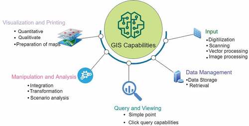
GIS is a tool for data input, storage, retrieval, manipulation, analysis, and output of spatial data (Huisman, Citation2009). GIS plays a vital role in spatial decision-making. GIS allows users to combine multiple types of information depending on the data’s geographic and locational components. GIS allows users to create maps, integrate data, visualize scenarios, solve complicated issues, present persuasive ideas, and develop effective solutions(ESRI, Citation2022). GIS and its related technologies are progressively being recognized as useful tools for natural resource inventory studies and management (Campbell & Shin, Citation2011). Fundamentally, GIS is employed to provide perceptions into quantitative inquiries and decision-making. Figure represents five sets of geographic data handling capabilities performed by geographical information systems.
Figure 1. GIS capabilities.
Furthermore, geographic information systems are utilized for the collecting, storage, and analysis of objects and phenomena when the geographical position is an essential property or vital to the research. GIS is a better information system due to its spatial searching and overlay capabilities. GIS is a sophisticated and effective planning tool for resource managers and decision-makers in calculating and analyzing large datasets in a short amount of time. Because of these characteristics, GIS has been used in a wide range of industries, including urban and rural planning, natural resource management, military, business, and agriculture.
Remote sensing is the art, science and technology of obtaining information about objects especially using aircraft or satellites (NOAA, Citation2021). Remote sensors collected data by detecting energy from the earth. The energy can be light or any other form of electromagnetic radiation, force fields, or acoustic energy (Tempfli et al., Citation2009). A remote sensor can be a conventional camera. Light reflected from an object passes through the lens and the light-sensitive film detects it, and a latent image is recorded. A photograph is then developed and generated in the photo lab for interpretation (Tempfli et al., Citation2009). RS defined as above, is applied in many fields, including architecture (Citation2021), archaeology (Villa, Citation2011), medicine (Suzuki et al., Citation2012), industrial quality control (Barsi et al., Citation2019), robotics (Guo & Wang, Citation2012), extra-terrestrial mapping (Nina et al., Citation2021), etc.
In agriculture, RS and GIS have enabled the spatio-temporal visualization of field information, allowing for monitoring crop and animal real-time conditions. GIS has been used in irrigation for a variety of purposes, including agricultural watershed management (Rudra et al., Citation1993), hydrology (Y. Chen et al., Citation2004), water productivity estimation (Tantawy, Citation2019), irrigation delivery monitoring (Rowshon et al., Citation2018), groundwater assessment (Megahed, Citation2020; Bhunia et al., Citation2018), calculating water demand (Santos et al., Citation2008), spatiotemporal variations of water requirements (Kyagulanyi et al., Citation2016).
(Rudra et al., Citation1993), hydrology (Y. Chen et al., Citation2004), water productivity estimation (Tantawy, Citation2019), Related Research
One of the motivations for this systematic literature review is to develop a rich and comprehensive understanding of the existing application domains of GIS and RS in irrigation systems. Specifically, concerning the application of GIS and RS in irrigation, to the best of our knowledge, there are very few Systematic Literature Reviews (SLR) available.
The most recent review papers in the realm of geospatial technologies in irrigation are by Maina et al. (Citation2014). The authors review the literature on web GIS-based support services for irrigation management in the study. In our view, the study presents valuable information for researchers on the different tools and future developments of web GIS in irrigation water management. Similarly, Saroj et al. (Citation2014) reviewed the use of geographical information systems in irrigation water management. The authors suggested that future research should concentrate on building GIS tools that deal with the unpredictability of spatial and temporal data. However, information technology is fast evolving, and various irrigation tools have subsequently been created. A few reviews on remote sensing, particularly remote sensing applications in agriculture, have been published. (Karthikeyan et al., Citation2020), application of remote sensing in precision agriculture (Sishodia et al., Citation2020), and remote sensing for agricultural crops (Alvino & Marino, Citation2017). Besides this study, very few reviews have been published regarding GIS and RS applications in irrigation systems. In the study, we discuss the different application domains of GIS and RS in irrigation and give future prospects of this field.
Our SLR is unique as it discusses the potential integration of other technologies to improve irrigation water management. Emerging technologies like cloud technology, real-time data, Internet of Things (IoT), 3D GIS, Mobile GIS and Unmanned Aerial Vehicles (UAVs), Big data and Machine Learning that are improving the capabilities and horizons of GIS are discussed in relation to agricultural water management.
2. Review methodology
The Systematic Literature Review (SLR) guidelines described by Xiao and Watson (Citation2019) were followed for this study. Keywords were chosen to obtain target results to address the study questions. The following search phrase was used for seeking the most relevant literature to our research:
(``GIS” OR `` Geographical Information System” OR `` Remote Sensing” OR ``Geomatics”)
AND
(“Irrigation” OR “Agricultural water management”).
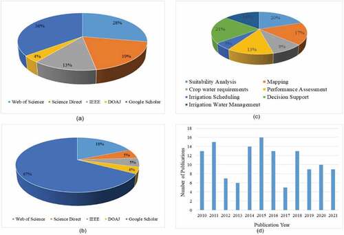
Web of Science, Science Direct, the Institute of Electrical and Electronics Engineers (IEEE), the Directory of Open Access Journals (DOAJ), and Google Scholar were all used in the search. Depending on the search parameters of a given database, the search was done using the title, keywords, or abstract fields. Despite the fact that GIS and remote sensing have been employed since the 1990s, we focused on published literature from 2010 to Citation2020. A total of 398 items of published literature were acquired from the databases, with Google Scholar accounting for 36% of the results, Web of Science accounting for 28%, Science Direct accounting for 19%, IEEE accounting for 13%, and DOAJ accounting for 4%. The number of articles collected from each of the databases analyzed for this investigation is shown in Table .
Table 1. Number of publications obtained from databases
Further analysis was performed on MS Excel following a procedure presented in Figure . The removal of duplicates was carried using the Conditional formatting tool in Excel. The quality check was conducted by reading the articles and judging the quality of work done. And using the search command in excel the application domains were obtained.The number of articled finally considered for this review was 76.
Figure 2. Selection criteria.
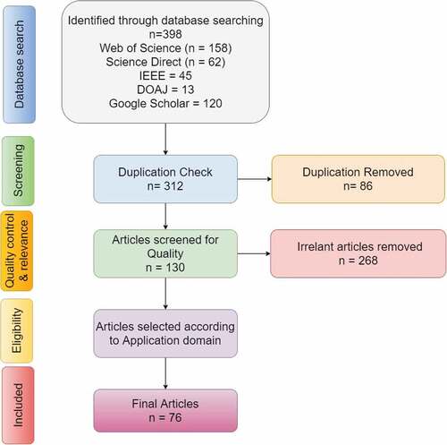
Figure presents the distribution of search results obtained from the databases. Figure presents the search results after duplicates have been removed in MS Excel. Figure shows the published literature according to the application domain, while Figure shows the studies published between 2010–2020 in this field.
Figure 3. Publications for the SLR: a) Before duplicates are removed b) After duplicates are removed, c) Publications according to application domain d) Number of publications per year.
3. Review findings and discussions
3.1. GIS-based irrigation suitability analysis
Suitability analysis is a technique of selecting the optimal place to locate goods or regions to conserve. The site to be selected relies on the site-specific characteristics. Various GIS applications contain suitability tools/Modelers used for performing out suitability studies. A suitability Modeler is an interactive, exploratory platform for generating and assessing a suitability model (ESRI, Citation2021). The Modeler delivers analytical input at each level of the model generation process and enables for smooth back and forth movement between stages. (ESRI, Citation2021).
In recent years, Geographical Information Systems have been applied to evaluate the suitability of land for irrigated agriculture (Aldababseh et al., Citation2018; El Baroudy et al., Citation2020; Elnashar et al., Citation2021; Seif-Ennasr et al., Citation2020). Not every land has suitability attributes for irrigation. Data on soils, land use/land cover, climate, distance from water resources, slopes and crops are collected and analyzed using GIS. The data is used to develop slope, land-use/landcover, climate, soil, and water resource maps, which are then categorized into suitability classes based on different criteria (Mandal et al., Citation2018). Figure presents the process for land suitability evaluation for irrigation using GIS.
Figure 4. Flowchart for land suitability for irrigation. adapted from (AL-Taani et al., Citation2021).
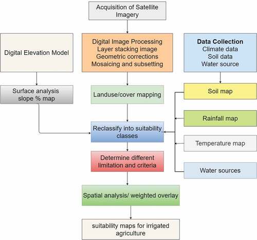
Several researchers have used GIS in land suitability analysis; for example, AL-Taani, Al-husban, et al. (Citation2021) used GIS and RS techniques to assess land suitability for agricultural use in Jordan. Rainfall, temperature, slope %, soil types, and water well distribution were all studied geographically by the authors. According to the authors, just 0.2 percent of Ma’an’s total land is appropriate for rainfed agriculture, whereas 1.4 percent is suitable for irrigated crops. The authors ascribe the low levels of agricultural land suitability to poor soil fertility and water shortages. Simillarily, Paul et al. (Citation2020) used geospatial multi-criteria decision analysis to assess agricultural land irrigation with reclaimed water. The researchers discovered a substantial relationship between the geographical distribution of appropriate regions for recovered water reuse in agricultural areas. A summary of search results for suitability analysis studies in irrigation is presented in Table .
Table 2. Suitability analysis studies using GIS and RS
3.2. Mapping in irrigation
In addition to evaluating land for irrigation, GIS can be used to accurately map irrigated areas which are vital in achieving precision in irrigation. Data is acquired from satellites like MODIS, LandSat and AVHRR to detect irrigated areas. Spectral patterns of the data are analyzed to classify irrigated, and non-irrigated areas and also spatio-temporal variations of irrigation can be assessed. This is achieved through the spectral reflectance concept that is compared with other land use and land cover types (Karthikeyan et al., Citation2020). GIS has also been used in groundwater potential mapping, soil salinity mapping, and irrigation infrastructure mapping, as seen in Table .Citation2020
Table 3. Mapping in irrigated agriculture
Several researchers have used this procedure to map irrigated agricultural systems. Gumma et al. (Citation2011) mapped irrigated areas in Ghana using MODIS data at 30 m and 250 resolution, Ketchum et al. (Citation2020) used Irrimapper, using machine learning approaches to determine the trends and extent of irrigation coverage in the United States and noted a 15% increase of irrigated agriculture over 33 years. Vogels et al. (Citation2019) presented an object-based approach to map irrigated agriculture in the Central Rift Valley in Ethiopia using SPOT6 imagery. The authors came to the conclusion that SPOT6 imagery and GIS mapping are beneficial for assessing spatiotemporal dynamics of irrigated (smallholder) agriculture in complicated terrain and provide a foundation for agricultural land and water management. Mapping irrigated areas and rainfed areas under the same cropping conditions was done by Jin et al. (Citation2016) in China using Normalized Difference Vegetation Index (NDVI) at a 30 × 30 m spatial resolution derived from the Chinese HJ-1A/B.
The process of measuring soil salinity entails locating hotspots in an irrigated area. The following GIS tools are necessary for soil salinity mapping: Excel, ArcMap with the spatial analyst extension, Arc Toolbox, and Arc Catalog. To generate continuous surface maps from discrete sample points, the Spatial Analyst extension is necessary. Additionally, this expansion offers a wide range of analytic and spatial modelling capabilities, such as converting features (points, lines, and polygons) to rasters, carrying out zone and neighborhood studies, and modelling and analysing both raster and vector data. ArcPad and Geostatistical Analyst are further optional programs and extensions. Using a hand-held device equipped with a GPS, ArcPad is an application used to specify and georeference the boundaries of the surveyed area The Geostatistical Analyst extension can be used to define a spatial model that will be integrated into the kriging interpolation. New trends in mapping irrigated areas involve the use of advanced technologies, object-based image classification and non-parametric machine learning algorithms, and artificial intelligence evolved in a GIS environment (Basukala et al., Citation2017;; Ketchum et al., Citation2020).
3.3. Determination of crop water requirements
The amount of water a crop needs to grow in wide fields under unrestrictive soil conditions, such as soil water and fertility, and to reach its maximum output potential in the given growing environment is known as the crop’s water requirements (Pereira & Alves, Citation2013). Crop evapotranspiration is a product of reference evapotranspiration and the crop coefficient. Detailed information on crop water requirements can be found in R. G. Allen et al. (Citation1998).
In a GIS environment, crop water requirements are estimated spatially using an inbuilt FAO Penman-Monteith Model that estimates the reference crop evapotranspiration. Monthly crop coefficients values are associated with each crop class and a reference evapotranspiration map derived from meteorological data (Casa et al., Citation2009). Several researchers have used this approach to determine crop evapotranspiration (Elnashar et al., Citation2021; Fares et al., Citation2016; Ramírez-Cuesta et al., Citation2018; Tessema Roba et al., Citation2021; Garrido-Rubio et al., Citation2018). Reyes-González et al. (Citation2018) estimated crop water use using a satellite-based vegetation index in northern Mexico for four growing seasons. The authors developed crop evapotranspiration maps which were used for irrigation scheduling. Similarly, Ramírez-Cuesta et al. (Citation2018) developed a novel ArcGIS toolbox which has been useful in estimating the amount of water required by a crop by integrating a dual crop coefficient method with multi-satellite imagery. The tool is appropriate for irrigation scheduling and other applications that account for water balance in agroecosystems.
For mapping and tracking ETa (actual evapotranspiration) at the field size, remote sensing methods using satellite and aircraft photography have become more popular in recent years. For example, potential differences in spatial and temporal resolutions have proved helpful for calculating ETa based on thermal infrared (TIR) data. Additionally, a number of sensors have been extensively used for mapping ETa in irrigated agricultural areas, including Landsat-TM/OLI (60–120 m), Moderate-resolution Imaging Spectrometer (MODIS) (1 km), ASTER (90 m), and GOES (4 km). The capabilities were recently improved with the start of the ESA’s Sentinel-2 and Sentinel-3 missions. The lack of fine spatial resolution in satellite TIR pictures is a key drawback despite extensive study on ETa estimates with satellites. Furthermore, ground validation is still insufficient.
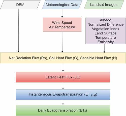
Geospatial models can provide spatial estimates of actual evapotranspiration (ETa) through the integration of satellite and meteorological data. These models include Surface Energy Balance Algorithm for Land, SEBAL (Bastiaanssen et al., Citation1998), SEB, Mapping Evapotranspiration with Internalized Calibration, METRIC (Richard G. Allen et al., Citation2007), PySEBAL and FAO’s ET-Look based WaPOR product (FAO, Citation2018b). The ETa obtained from these algorithms is used in irrigation scheduling calculations. Although it is a reasonable assumption that ETa is crop water requirement, this may not be the case in water-stressed conditions because the soil water limits ETa. ETa information provides an estimate of how much water a farmer should apply (Govind, Citation2021).Remote sensing Based determination of evapotranspiration is presented in Figure .
Figure 5. Remote sensing determination of evapotranspiration.
3.4. Irrigation scheduling
Irrigation Scheduling is the process of deciding when and how much to irrigate. Optimal irrigation scheduling is important to ensure that crop water requirements are met and also in saving water (Bwambale et al., Citation2022). GIS has been applied in irrigation scheduling. Rowshon et al. (Citation2003)Citation2003 developed a program using GIS for the spatial and temporal distribution of irrigation supply for Malaysia’s large-scale rice irrigation system. The system determined and delivered water periodically based on spatial and temporal demand. Fortes et al. (Citation2005) used a GIS-based irrigation scheduling simulation model to support improved water use. The model implemented a 15–20-day time interval between irrigations. In addition, the model was useful in handling time series of weather data. Table presents a summary of published literature that has used GIS for irrigation scheduling applications.
Table 4. GIS-enabled irrigation scheduling
3.5. Irrigation systems management
The right allocation of water resources to distribute irrigation water with variable irrigation requirements is necessary to improve irrigation scheme management. Crop water requirements may vary in space and time and using the spatial data management and utilization tools of GIS, the Spatio-temporal variation in water allocation can be harmonized (Rowshon et al., Citation2009)Citation2009. GIS provides an effective information system of the scheme that is interactive and representative of the hierarchy of irrigation system operation. Rowshon et al. (Citation2009) developed a Rice Irrigation Management System (RIMIS) in a GIS environment. The developed system was able to provide information on the uniformity of water distribution, with maps as output, irrigation managers were able to make informed decisions in regard to the operation and management of the scheme. Likewise, Garrido-Rubio et al. (Citation2020)Citation2020; Maina et al. (Citation2014); Mohd et al. (Citation2014); ; Valencia et al. (Citation2020)Citation2020; and Yang et al. (Citation2016) have applied GIS and RS techniques in designing irrigation canals, visualization of water management and demand, groundwater assessment, and evaluating irrigation approaches under various environmental conditions.
3.6. Decision support systems
GIS and RS have been used in the development of spatial decision support tools for irrigation management. Geospatial systems provide a framework for combining database management systems, analytical models, and graphics to facilitate decision-making from the field to basin scale. Fortes et al. (Citation2005) developed a graphical user interface for irrigation management with the support of GIS customization using Visual Basic for Application (VBA). Table presents a summary of GIS-enabled decision support systems published in recent times for irrigation management.
Table 5. GIS-based decision support systems for irrigation management
3.7. Irrigation performance assessments
The systematic observation, documenting, and interpretation of activities connected to irrigated agriculture with the goal of continual improvement may be characterized as irrigation system performance assessment (Bwambale et al., Citation2019b). Evaluation of irrigation scheme performance is possible when water balance and information is combined with remotely sensed evapotranspiration. Recent developments in GIS and RS make it possible to assess irrigation performance on a pixel-by-pixel basis (Taghvaeian et al., Citation2018). Performance Indicators like adequacy, equity, dependability, sustainability ratio, drainage ratio and drainage uniformity were estimated by Taghvaeian et al. (Citation2018) using GIS. Nikam et al. (Citation2020) used indicators of agricultural performance, water delivery performance and physical performance using remotely sensed data and GIS to evaluate the performance of a large scale irrigation project at a disaggregated level. The authors reported that the project positively impacted agriculture and economic growth of the region, despite excessive water logging in some parts of the command area and inadequacy at the tail end. Zafar et al. (Citation2021) demonstrated that using remote sensing-derived information to complement classic canal flow data with spatially discrete field-level water use information is essential to improve equity in canal water delivery in Punjab, Pakistan. Various organizations have developed models for monitoring land and water productivity. They make use of satellite data that is input and analyzed in a GIS environment to determine land and water productivity using inbuilt algorithms (Bastiaanssen & Steduto, Citation2017). FAO’s WaPOR database helps monitor agricultural water productivity using satellite data analyzed in a GIS environment (FAO, Citation2018a, Citation2018b). Researchers (Blatchford et al., Citation2018, Citation2020; Sawadogo et al., Citation2020; Tantawy, Citation2019) have already used this database to monitor agricultural water productivity. The authors report that the GIS-enabled database is very accurate and important in estimating water productivity in production areas where field data is unavailable. This makes GIS a very important tool in estimating the productivity of land in both rainfed and irrigated agricultural systems.
4. Opportunities and challenges of GIS and RS technologies
GIS and remote sensing have shown to be excellent methods for monitoring irrigated areas in various locations throughout the globe under various environmental circumstances. They offer synoptic coverage of irrigated fields in numerous spectral areas and with temporal frequencies suitable to estimate agricultural water usage at various crop development stages. Furthermore, archival data that spans several years allows for picture comparison, demonstrating evolution. Because satellite data is digital, it is extremely simple to incorporate into a GIS for synthesis or comparison with other data sources. Remote sensing reduces the cost and time required to acquire datasets compared to conventional statistical surveys, which may entail aerial photography over huge regions. As a result, GIS and remote sensing technologies have become vital in underdeveloped nations where financing for data collecting for irrigation research is limited. Moreso, remote sensing offers meaningful geographical information on the specific locations of irrigated areas rather than just totals inside arbitrary administrative subdivisions. This is vital for optimizing water distribution, measuring irrigation performance, giving irrigation schedules, enumerating environmental effect, objectively assessing irrigation water consumption and understanding irrigation dynamics (Ozdogan et al., Citation2010). Finally, remote sensing may give timing data, both in terms of the number of irrigation-related vegetation peaks and the amount of time irrigation is used over the course of a year.
Difficulty distinguishing between irrigated and non-irrigated lands. In humid places, separating irrigated fields from non-irrigated plots is challenging due to significant overlap in their spectral signatures. For example, during some development phases, the fingerprints of flooded irrigated fields may overlap with those of natural wetlands, reducing mapping accuracy. Researchers have addressed these constraints by combining time information on crop planting, maturity, and harvest with spectral data. Unfortunately, the gathering of remotely sensed data is limited by the orbit and return interval of a specific satellite, thus observations are not always caught at optimal periods. The availability of optical data is also a challenge in locations with regular cloud cover, such as humid tropical and subtropical settings.
The other difficulty faced with geospatial technology is real-time irrigation scheduling. Precision irrigation management attempts to provide the plant with the optimal moisture conditions in both time and space. These geospatial technologies, particularly satellite images, are unable to provide real-time data collecting to aid with irrigation scheduling choices. This complicates matching crop water demand with supply across wide regions in time and space.
Finally, detecting agricultural fields via remote sensing is problematic because irrigated landscapes are a subtype of croplands, which have historically proven difficult to map. Agrarian fields (particularly irrigated fields) are very dynamic since each field is at a distinct stage of development and hence may be mistaken with natural land cover classes. The categorical detail of land-cover maps is often negatively proportional to their accuracy. Because agriculture is difficult to identify and map in and of itself, recognizing irrigated regions as a subclass of farming becomes much more challenging. Perhaps here is where temporal data profiles will come in handy for distinguishing irrigation from rainfed crops.
GIS and RS technologies do not work in isolation; they must be integrated with other tools to acquire, store, visualize, analyze, and output geographical data effectively. The combination of geospatial technology with advances in agricultural Internet of Things, Artificial Intelligence, 3D GIS, Mobile GIS, Big data, and Machine Learning makes collecting and processing spatiotemporal agricultural data simpler.
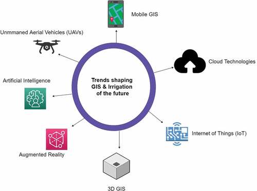
5. Future prospects and emerging technologies for precision irrigation management
A GIS professional market and application survey of more than 200 respondents revealed that major trends in technological advancements that will become their organizations point out cloud technology, real-time data, Internet of Things(IoT), 3D GIS, Mobile GIS, Unmanned Aerial Vehicles (UAVs) and Artificial Intelligence (USC, Citation2021; see, Figure ). These advancements will not only be limited to other sectors but also agriculture and irrigation, to be specific. These advancements will improve irrigation management of the future in the following ways.
Figure 6. Technological advancements that will shape future irrigation systems.
5.1. Cloud technology and GIS in irrigation systems
In precision irrigation technologies, cloud computing combined with geographical information systems will be critical to ensure variable rate application. In the cloud, revolutionary algorithms and software have the potential of thoroughly analyzing field conditions to estimate spatially distributed crop water requirements (Debauche et al., Citation2018). The data can then be communicated to an irrigation control to perform for actuation. The farmer then can view soil moisture status on his smartphone or a web interface and with just a click, the farmer can control the system where he/she is. This has the potential of saving irrigation water and eliminating high operational costs.
Complex computations from ET algorithms can easily be handled and data sent to a GIS-enabled smartphone in the form of irrigation water to be applied. Forcén-Muñoz et al. (Citation2022) described the Irriman Platform, a system based on cloud computing techniques, which includes low-cost wireless data loggers, capable of acquiring data from a wide range of agronomic sensors, and novel software architecture for safely storing and processing such information, making crop monitoring and irrigation management easier. The proposed platform helps agronomists optimize irrigation procedures through a web-based tool that allows them to elaborate irrigation plans and evaluate their effectiveness over crops. Similarly, Younes and Salman (Citation2021) developed a cloud-based smart irrigation system leveraging satellite data. The system provides communication interfaces to trigger irrigation scheduling in the field. The application enables building a decision-support system that allows an inexperienced farmer to practice productive farming in a semi-automated manner. Other applications include, among others, the determination of actual evapotranspiration (Laipelt et al., Citation2021), assessing irrigated area expansion (Naboureh et al., Citation2021), and automated mapping of cropped areas (Xiong et al., Citation2017)
5.2. Internet of things for irrigation management
The advent of the Internet of Things (IoT) has resulted in a paradigm shift in agricultural water management. Traditionally, farmers use heuristic approaches to schedule irrigation which oftentimes results into over or under irrigation (Kashyap et al., Citation2021). Closed-loop control strategies ensure that the amount of water to be applied is determined by the current soil moisture status and prevailing crop environment. IoT provides a platform for precision irrigation, wirelessly connecting several soil sensors and other different hardware on the farm. The coupling of Geographical Information Systems with the Internet of Things is essential in the automation of irrigation systems. The combination of Geographical Information systems and IoT will bring a dynamic change in the irrigation industry and other sectors as well. IoT technology is one of those techniques in which, by using the normal internet protocol, the desired technology may wirelessly transmit the data gained by digitizing the data of the object or domain of the adapter that it is adapting to the server. With a system architecture comprising of soil moisture sensors, weather sensors and solenoids placed on sprinklers, Lora modulation and 4 G connection, real-time irrigation requirements can be met (Rehman et al., Citation2022).
Recently, Abioye, Abidin, et al. (Citation2021) implemented an IoT-based monitoring and data-driven modelling of drip irrigation system for mustard leaf cultivation experiment. The authors used plant sensors to monitor water stress and weather sensors to monitor the plant environment conditions and the data was sent over a wireless sensor network. The system was able to schedule irrigation in real-time. Other applications of IoT Integrated with GIS/RS include Real-time detection of irrigation water pollution (Lin et al., Citation2020), estimation of leaching requirement (Bashir et al., Citation2020), irrigation scheduling for water management (Roy et al., Citation2021) and irrigation management (Liu, Citation2021).
5.3. Augmented reality and virtual reality
Augmented reality is a field of research that combines the real environment and computer-generated data to increase the human perception of a scene in real-time, enhancing visible details and displaying invisible or inexistent objects (Mirauda et al., Citation2017). This virtual-real merge is achieved via the appropriate Graphical User Interfaces (GUIs) on the user’s hand-held portable devices (smartphones, tablets, etc.). Future outdoor activities will be transformed by augmented reality. It gives mobile field personnel a handy tool for visualizing their surroundings, providing related information, and reducing the need to read maps and documentation while monitoring and managing operations. This will assist in bridging the gap between GIS data on a PC that is not helpful to field employees in real-time. An irrigator may use augmented reality to aim a phone camera at the ground and observe the position and direction of water pipelines and power wires buried under the earth. The AR software uses the GIS system and the irrigator’s position to visually represent the infrastructure underneath. This assists in detecting leaks in subsurface drip irrigation systems and subterranean conveyance pipelines.
5.4 3D GIS
3D GIS adds another dimension(z) to objects for greater details and visibility 3D GIS adds an elevation component to objects that 2D maps are unable to provide. 3D technologies in GIS maps gives explanatory illustrations to represent the scale of real-world objects (Jacob, Citation2019). The models in three dimensions result in a great appearance, aiding surveying in different domains. Integrating 3D technologies can help irrigation engineers envision, evaluate and analyze how certain changes in irrigation layouts will look like, and how sustainable the changes are. A typical 3D model would consist of irrigation infrastructure information, satellite imagery and data to help irrigation designers decide on the most economical routes for irrigation conveyance systems. In ArcGIS, it is possible to integrate 2D GIS and 3D GIS for greater visualization and simulations of irrigation systems (Yang et al., Citation2016). With this integration, it is possible to assess the impact of flooding on irrigated agriculture in 3D using GIS 3D spatial analysis tools.
By using 3D geographic information system (3D GIS) and remote sensing (RS) technologies, Cheng et al. (Citation2015) offered a simple, practical, and cost-effective technique. 3D terrain and ground feature models were built interactively using multi-source data such as Google Earth (GE) high-resolution remote sensing images, ASTER G-DEM, hydrological facility maps, etc. After that, both models were produced with texture data and linked into the ArcGIS platform. A vibrant, realistic 3D virtual picture of an irrigation field was created with a nice visual impact and basic GIS tools for data retrieval and analysis.
5.5 Mobile GIS
Mobile GIS makes it easier to conduct feasibility studies for irrigation development by allowing field personnel to gather, save, update, edit, analyze, and display geospatial data and information. This is made possible by integrating mobile devices, GIS software, GPS, and wireless connections that provide internet-based GIS access. With mobile GIS, it is possible to make changes and updates in real-time while collecting data, accelerating processing and increasing accuracy. Several mobile GIS applications have been developed for numerous purposes, and because to significant developments in mobile technology, these applications now go well beyond basic mapping (Mostafa, Citation2019). Some of these applications were developed by private sector companies for commercial purposes. Weather forecasting, acquiring market prices, and detecting plant diseases are a few examples of mobile GIS applications purposefully designed for irrigated agricultural systems.
5.6 Unmanned aerial vehicles
An unmanned aerial vehicle (UAV) is an aircraft that carries no human pilot or passengers. UAVs, sometimes called “drones” can be fully or partially autonomous but are more often controlled remotely by a human pilot (RAND, Citation2020). Unmanned aerial vehicles (UAVs) are evolving toward autonomy, choosing where to fly based on deep learning, a variety of navigational signals, and sensor data. In order to create accurate 3D models and orthophotos of a region of interest, on-demand detailed picture gathering with UAVs is a quick and affordable alternative (Giacomo & David, Citation2018). UAV‐based remote sensing and GIS mapping of processed data can be used for irrigation scheduling, plant water status assessment and nutrient assessment applications. Recent studies have applied UAVs in energy balance of an irrigated field (Ortega-Farias et al., Citation2021), surface moisture mapping (Zeyliger et al., Citation2022) and determination of actual evapotranspiration (Mokhtari et al., Citation2021). Remote sensing using unmanned aerial vehicles can provide precise information of irrigated crop areas through monitoring the phenological development of crops through multi-temporal images.
5.7 Big data and machine learning
To deliver sustainable irrigation, irrigation managers need to employ cutting edge technologies like big data, machine learning and blockchain. Data-driven- precision irrigation with these technologies is the most promising approach to solve existing and future problems (Alfred et al., Citation2021; Bhat & Huang, Citation2021; Kashyap et al., Citation2021). Once vast data is obtained from an irrigated field, it can be used to drive irrigation and other farming decisions. Data-driven agriculture has been proven to improve crop yield, reduce cost, and ensure sustainability. The integration of GIS, RS with Big data and machine learning encourages the automation of farm data collection, analysis and decision making. GIS-based data management systems have been developed to help farmers with specific irrigation-related tasks like weather prediction, mapping, irrigation scheduling, automated field management, Big data, and Machine Learning tools and the increase in computational power has made it possible to develop algorithms from data collected from the field either by UAVs, satellites and sensors to make decisions.
Data-driven machine learning models for irrigation have gained attention (Abioye, Abidin, Aman et al., Citation2021; Bwambale et al., Citation2022, Citation2023; Lozoya et al., Citation2014; McCarthy et al., Citation2014)) over physical/mechanistic models to predict soil moisture content because data-driven models require less data for calibration as compared to mechanistic model calibration. In addition, ML models process spatial and temporal data easily in less time and show good predictive performance over physical models. The ML model-based irrigation systems have a closed-loop controller that learns from calibration, in which the system itself employs feedback from the comparison between pre-processed data and measured real-time data (Abioye et al., Citation2023).
Big data and machine learning techniques have been applied in paddy rice to ensure the optimum water level is maintained in the field. Climate data is obtained using satellites, drones ae used in monitoring water stress while a wireless sensor network is used to build a smart irrigation system for paddy. Significant increases in yields have been reported using this approach of maintaining a certain amount of water in the paddy field using a data-driven approach.
6. Conclusion
This study examines the most current uses of Geographical Information Systems in irrigation. Furthermore, developing technologies in irrigation management are highlighted. Geographical Information Systems have been used in land suitability analysis mapping, crop water consumption estimation, irrigation scheduling, productivity monitoring, and irrigation performance evaluations. Combining GIS with existing irrigation management systems is more powerful and effective when dealing with significant amounts of geographical and temporal data. It is used to organize, retrieve, and show geographical and geographic data for irrigation at the field or basin size. Despite the fact that a few tools and systems have been developed to simulate irrigation models, there is still a need for new tools to examine spatial irrigation water needs, which might be produced by altering current GIS software. Technological and application advancements in GIS will determine the future usage of these geospatial tools in irrigation systems. Integration of cloud computing, Internet of Things Big Data and Machine Learning, 3D GIS, Mobile GIS, Augmented and Virtual Reality, and Unmanned Aerial Vehicles with GIS and Remote Sensing technologies will transform agriculture and continue to play an important role in agriculture 5.0. In site-specific precision irrigation, smart irrigation systems like as drip and sprinkler irrigation are widely employed. With water supplies becoming scarce, sophisticated water management and irrigation techniques are required to conserve this valuable resource. To address under- or over-irrigation issues, as well as soil leaching or drying, requirement-based irrigation may be carried out utilizing a mix of geospatial technologies, information systems, and decision support systems.
Acknowledgements
The authors are grateful to the West African Centre for Water, Irrigation and Sustainable Agriculture (WACWISA), and the University for Development Studies.
Disclosure statement
No potential conflict of interest was reported by the author(s).
Additional information
Funding
Notes on contributors

Erion Bwambale
Erion Bwambale is a PhD Candidate at the West African Center for Water, Irrigation and Sustainable Agriculture (WACWISA) hosted at the University for Development Studies in Ghana. Erion is an early-career researcher passionate about irrigation systems modelling for improved water use efficiency. He is also the Irrigation Engineer and co-founder at Irrisol Engineering Ltd, a company that provides farmers with custom-designed water and irrigation solutions in Uganda. He holds a masters degree in Civil Engineering with a specialization in Irrigation and Drainage from Jomo Kenyatta University of Agriculture and Technology, Kenya and a B.Sc in Agricultural Mechanization and Irrigation Engineering, Busitema University, Uganda. He is a Member of ASABE, ASCE, PASAE and ICID.
References
- Abdalla, F. (2012). Mapping of groundwater prospective zones using remote sensing and GIS techniques: A case study from the central eastern desert, Egypt. Journal of African Earth Sciences, 70 , 8–22. https://doi.org/10.1016/j.jafrearsci.2012.05.003
- Abioye, E. A., Abidin, M. S. Z., Mahmud, M. S. A., Buyamin, S., AbdRahman, M. K. I., Otuoze, A. O., Ramli, M. S. A., & Ijike, O. D. (2021). IoT-based monitoring and data-driven modelling of drip irrigation system for mustard leaf cultivation experiment. Information Processing in Agriculture, 8(2), 270–283. https://doi.org/10.1016/j.inpa.2020.05.004
- Abioye, E. A., Abidin, M. S. Z., Aman, M. N., Mahmud, M. S. A., & Buyamin, S. (2021). A model predictive controller for precision irrigation using discrete lagurre networks. Computers and Electronics in Agriculture, 181(July 2020), 105953. https://doi.org/10.1016/j.compag.2020.105953
- Abioye, E. A., Shukri, M., Abidin, Z., Saiful, M., Mahmud, A., Buyamin, S., Denis, O., Okino, A., Abiodun, A., & Musbau, O. (2023). Smart agricultural technology a data-driven kalman filter-PID controller for fibrous capillary irrigation. Smart Agricultural Technology, 3(April 2022), 100085. https://doi.org/10.1016/j.atech.2022.100085
- Abu-Hashim, M., Sayed, A., Zelenakova, M., Vranayova, Z., & Khalil, M. (2021). Soil water erosion vulnerability and suitability under different irrigation systems using parametric approach and. Sustainability (Switzerland), 13(3), 1057. https://doi.org/10.3390/su13031057
- Al-taani, A., Al-husban, Y., & Farhan, I. (2021). The Egyptian journal of remote sensing and space sciences land suitability evaluation for agricultural use using GIS and remote sensing techniques : The case study of Ma ’ an governorate, Jordan. The Egyptian Journal of Remote Sensing and Space Sciences, 24(1), 109–117. https://doi.org/10.1016/j.ejrs.2020.01.001
- AL-Taani, A., Al-husban, Y., & Farhan, I. (2021). Land suitability evaluation for agricultural use using GIS and remote sensing techniques: The case study of Ma’an governorate, Jordan. Egyptian Journal of Remote Sensing and Space Science, 24(1), 109–117. https://doi.org/10.1016/j.ejrs.2020.01.001
- Aldababseh, A., Temimi, M., Maghelal, P., Branch, O., & Wulfmeyer, V. (2018). Multi-criteria evaluation of irrigated agriculture suitability to achieve food security in an arid environment. Sustainability (Switzerland), 10(3), 803. https://doi.org/10.3390/su10030803
- Alfred, R., Obit, J. H., Chin, C. P. Y., Haviluddin, H., & Lim, Y. (2021). Towards paddy rice smart farming: A review on big data, machine learning, and rice production tasks. IEEE Access, 9 , 50358–50380. https://doi.org/10.1109/ACCESS.2021.3069449
- Allen, R. G., Pereira, L. S., Raes, D., & Smith, M. (1998). Crop evapotranspiration. guidelines for computing crop water requirements. FAO Irrigation and drainage paper 56. Food and Agricultural Organization of the United Nations.
- Allen, R. G., Tasumi, M., Morse, A., Trezza, R., Wright, J. L., Bastiaanssen, W., Kramber, W., Lorite, I., & Robison, C. W. (2007). Satellite-based energy balance for mapping evapotranspiration with internalized calibration (METRIC)—applications. Journal of Irrigation and Drainage Engineering, 133(4), 395–406. https://doi.org/10.1061/(asce)0733-9437(2007)133:4(395)
- Alvino, A., & Marino, S. (2017). Remote sensing for irrigation of horticultural crops. Horticulturae, 3(2), 40. https://doi.org/10.3390/horticulturae3020040
- Andrade, M. A., O’Shaughnessy, S. A., & Evett, S. R. (2016). A GIS-based decision support tool for center pivot irrigation systems. 2016 American society of agricultural and biological engineers annual international meeting, ASABE 2016, December. https://doi.org/10.13031/aim.20162461449
- Asfaw, E., Suryabhagavan, K. V., & Argaw, M. (2018). Soil salinity modeling and mapping using remote sensing and GIS: The case of Wonji sugar cane irrigation farm, Ethiopia. Journal of the Saudi Society of Agricultural Sciences, 17(3), 250–258. https://doi.org/10.1016/j.jssas.2016.05.003
- Barsi, Á., Kugler, Z., Juhász, A., Szabó, G., Batini, C., Abdulmuttalib, H., Huang, G., & Shen, H. (2019). Remote sensing data quality model: From data sources to lifecycle phases. International Journal of Image and Data Fusion, 10(4), 280–299. https://doi.org/10.1080/19479832.2019.1625977
- Bashir, R. N., Bajwa, I. S., & Shahid, M. M. A. (2020). Internet of things and machine-learning-based leaching requirements estimation for saline soils. IEEE Internet of Things Journal, 7(5), 4464–4472. https://doi.org/10.1109/JIOT.2019.2954738
- Bastiaanssen, W. G. M., Meneti, M., Feddes, R. A., & Holtslag, A. A. M. (1998, January). A remote sensing surface energy balance algorithm for land (SEBAL). Journal of Hydrology, 212-213(213), 198–212. https://doi.org/10.1016/S0022-1694(98)00253-4
- Bastiaanssen, W. G. M., & Steduto, P. (2017). The water productivity score (WPS) at global and regional level: Methodology and first results from remote sensing measurements of wheat, rice and maize. Science of the Total Environment, 575 , 595–611. https://doi.org/10.1016/j.scitotenv.2016.09.032
- Basukala, A. K., Oldenburg, C., Schellberg, J., Sultanov, M., & Dubovyk, O. (2017). Towards improved land use mapping of irrigated croplands: Performance assessment of different image classification algorithms and approaches. European Journal of Remote Sensing, 50(1), 187–201. https://doi.org/10.1080/22797254.2017.1308235
- Bazzi, H., Baghdadi, N., Ienco, D., Hajj, M. E., Zribi, M., Belhouchette, H., Escorihuela, M. J., & Demarez, V. (2019). Mapping irrigated areas using sentinel-1 time series in Catalonia, Spain. Remote Sensing, 11(15), 1–25. https://doi.org/10.3390/rs11151836
- Belaud, G., Mateos, L., Aliod, R., Buisson, M. C., Faci, E., Gendre, S., Ghinassi, G., Gonzales Perea, R., Lejars, C., Maruejols, F., & Zapata, N. (2020). Irrigation and energy: Issues and challenges. Irrigation and Drainage, 69(S1), 177–185. https://doi.org/10.1002/ird.2343
- Bhat, S. A., & Huang, N. F. (2021). Big data and ai revolution in precision agriculture: Survey and challenges. IEEE Access, 9 , 110209–110222. https://doi.org/10.1109/ACCESS.2021.3102227
- Bhunia, G. S., Keshavarzi, A., Shit, P. K., Omran, E.-S. E., & Bagherzadeh, A. (2018). Evaluation of groundwater quality and its suitability for drinking and irrigation using GIS and geostatistics techniques in semiarid region of Neyshabur, Iran. Applied Water Science, 8(6), 1–16. https://doi.org/10.1007/s13201-018-0795-6
- Blatchford, M., Stokvis, B., Galindo, A., Blatchford, M., & Hoekstra, A. Y. (2018). Database methodology : Level 3 data. The Science of the Total Environment, 653 :241–252. Issue August 2019. https://doi.org/10.1016/j.scitotenv.2018.10.311.
- Blatchford, M., Mannaerts, C. M., Zeng, Y., Nouri, H., & Karimi, P. Influence of spatial resolution on remote sensing-based irrigation performance assessment using WaPOR data. (2020). Remote Sensing, 12(18), 2949. https://doi.org/10.3390/RS12182949
- Bwambale, E., Home, P., Raude, J., & Wanyama, J. (2019a). Development of a water allocation model for equitable water distribution at doho rice irrigation scheme, Uganda. Hydrology, 7(4), 62. https://doi.org/10.11648/j.hyd.20190704.12
- Bwambale, E., Home, P., Raude, J., & Wanyama, J. (2019b). Hydraulic performance evaluation of the water conveyance system of doho rice irrigation scheme in Uganda. Journal of Sustainable Research in Engineering, 5(December), 101–112. http://sri.jkuat.ac.ke/ojs/index.php/sri
- Bwambale, E., Abagale, F. K., & Anornu, G. K. (2022). Smart irrigation monitoring and control strategies for improving water use efficiency in precision agriculture : A review. Agricultural Water Management, 260(107324), 1–12. https://doi.org/10.1016/j.agwat.2021.107324
- Bwambale, E., Abagale, F. K., & Anornu, G. K. (2023). Data-driven model predictive control for precision irrigation management. Smart Agricultural Technology, 3(May 2022), 100074. https://doi.org/10.1016/j.atech.2022.100074
- Campbell, J., & Shin, M. E. (2011). Essentials of Geographical Information Systems, 259 (https://www.saylor.org/books/) ISSN:978-1-4533219-6-6 https://digitalcommons.liberty.edu/textbooks/2 .
- Casa, R., Rossi, M., Sappa, G., & Trotta, A. (2009). Assessing crop water demand by remote sensing and GIS for the pontina plain, central Italy. Water Resources Management, 23(9), 1685–1712. https://doi.org/10.1007/s11269-008-9347-4
- Chen, Y., Takara, K., Cluckie, I., & De Smedt, F. H. (2004). GIS and remote sensing in hydrology, water resources and environment. In IAHS Series of Proceedings and Reports (Vol. 289, Issue January 2004).
- Chen, Z., Wang, J., Sun, J., Duan, A., Liu, Z., Song, N., & Liu, X. (2012). Water-saving irrigation management and decision support system based on WEBGIS. IFIP Advances in Information and Communication Technology, 368 AICT(Part 1), 301–312. https://doi.org/10.1007/978-3-642-27281-3_36
- Cheng, S., Dou, M., Wang, J., Zhang, S., & Chen, X. (2015). Approach to constructing 3d virtual scene of irrigation area using multi-source data. ISPRS Annals of the Photogrammetry, Remote Sensing and Spatial Information Sciences, 2(2W2), 227–233. https://doi.org/10.5194/isprsannals-II-2-W2-227-2015
- Chikabvumbwa, S. R., Sibale, D., & Chisale, S. W. (2021). Irrigation site selection using hybrid GIS-based approach. International Journal F Human Capital in Urban Management, 6(2), 149–158. https://doi.org/10.22034/IJHCUM.2021.02.04
- Corwin, D. L., & Scudiero, E. (2019). Review of soil salinity assessment for agriculture across multiple scales using proximal and/or remote sensors. In Advances in agronomy (Vol. 158 , pp. 1–130). . https://doi.org/10.1016/bs.agron.2019.07.001
- Debauche, O., El Moulat, M., Mahmoudi, S., Manneback, P., & Lebeau, F. (2018). Irrigation pivot-center connected at low cost for the reduction of crop water requirements. Proceedings - 2018 International conference on advanced communication technologies and networking, commnet 2018, 1–9. https://doi.org/10.1109/COMMNET.2018.8360259
- Djuraev, A., Mirdjalalov, D., Nuratdinov, A., & Khushvaktov, T. (2021). Evaluation of soil salinity level through NDVI in Syrdarya province, Uzbekistan. E3S Web of Conferences, 03017.
- El Baroudy, A. A., Ali, A. M., Mohamed, E. S., Moghanm, F. S., Shokr, M. S., Savin, I., Poddubsky, A., Ding, Z., Kheir, A. M. S., Aldosari, A. A., Elfadaly, A., Dokukin, P., & Lasaponara, R. (2020). Modeling land suitability for rice crop using remote sensing and soil quality indicators: The case study of the Nile delta. Sustainability (Switzerland), 12(22), 1–25. https://doi.org/10.3390/su12229653
- Elnashar, A., Abbas, M., Sobhy, H., & Shahba, M. (2021). Crop water requirements and suitability assessment in arid environments: A new approach. Agronomy, 11(2), 260. https://doi.org/10.3390/agronomy11020260
- ESRI. (2021). The general suitability modeling workflow—ArcGIS Pro | Documentation. https://pro.arcgis.com/en/pro-app/latest/help/analysis/spatial-analyst/suitability-modeler/the-general-suitability-modeling-workflow.htm
- ESRI. (2022, February 26). What is GIS? | Geographic Information System Mapping Technology. https://www.esri.com/en-us/what-is-gis/overview
- FAO. (2018a). The future of food and agriculture – Alternative pathways to 2050. http://www.fao.org/3/I8429EN/i8429en.pdf
- FAO. (2018b). WaPOR Database methodology: Level 1 data. In Remote Sensing for Water Productivity Technical Report: Methodology Series.September). http://www.fao.org/fileadmin/user_upload/faoweb/RS-WP/pdf_files/Web_WaPOR-beta_Methodology_document_Level1.pdf
- FAO. (2020). Irrigation Management. https://pdf4pro.com/download/irrigation-management-aims-at-increasing-food-23697e.html#google_vignette
- Fares, A., Awal, R., Fares, S., Johnson, A. B., & Valenzuela, H. (2016). Irrigation water requirements for seed corn and coffee under potential climate change scenarios. Journal of Water and Climate Change, 7(1), 39–51. https://doi.org/10.2166/wcc.2015.025
- Forcén-Muñoz, M., Pavón-Pulido, N., López-Riquelme, J. A., Temnani-Rajjaf, A., Berríos, P., Morais, R., & Pérez-Pastor, A. (2022). Irriman platform: Enhancing farming sustainability through cloud computing techniques for irrigation management. Sensors, 22(1), 228. https://doi.org/10.3390/s22010228
- Fortes, P. S., Platonov, A. E., & Pereira, L. S. (2005). GISAREG - A GIS based irrigation scheduling simulation model to support improved water use. Agricultural Water Management, 77(1–3), 159–179. https://doi.org/10.1016/j.agwat.2004.09.042
- Fue, K. G., & Sanga, C. (2015). Remote scheduling system for drip irrigation system using geographic information system. Journal of Geographic Information System, 7(5), 551–563. https://doi.org/10.4236/jgis.2015.75044
- Garrido-Rubio, J., Calera Belmonte, A., Fraile Enguita, L., Arellano Alcázar, I., Belmonte Mancebo, M., Campos Rodríguez, I., & Bravo Rubio, R. (2018). Remote sensing-based soil water balance for irrigation water accounting at the Spanish Iberian Peninsula. Proceedings of the international association of hydrological sciences, 380, 29–35. https://doi.org/10.5194/piahs-380-29-2018
- Garrido-Rubio J, Calera A, Arellano I, Belmonte M, Fraile L, Ortega T, Bravo R and González-Piqueras J. (2020). Evaluation of Remote Sensing-Based Irrigation Water Accounting at River Basin District Management Scale. Remote Sensing, 12(19), 3187 10.3390/rs12193187
- Gebeyehu, M. N. (2019). Remote sensing and GIS application in agriculture and natural resource management. International Journal of Environmental Sciences & Natural Resources, 19(2), 556009. https://doi.org/10.19080/IJESNR.2019.19.556009
- Giacomo, R., & David, G. (2018). Gerard , Sylvester. In E-agriculture in action: Drones for agriculture. FAO and ITU 978-92-5-130246-0s https://www.fao.org/3/I8494EN/i8494en.pdf .
- Gorji, T., Tanik, A., & Sertel, E. (2015). Soil salinity prediction, monitoring and mapping using modern technologies. Procedia Earth and Planetary Science, 15 , 507–512. https://doi.org/10.1016/j.proeps.2015.08.062
- Govind, A. (2021). Physics of remote sensing and sensor characteristics : A Primer. Remote Sensing Determination of Evapotranspiration.
- Gumma, M. K., Thenkabail, P. S., Hideto, F., Nelson, A., Dheeravath, V., Busia, D., & Rala, A. (2011). Mapping irrigated areas of Ghana using fusion of 30 m and 250 m resolution remote-sensing data. Remote Sensing, 3(4), 816–835. https://doi.org/10.3390/rs3040816
- Guo, F., & Wang, Y. (2012). Study of remote sensing and remote sensing robot technology. Applied Mechanics and Materials, 214 , 914–918. https://doi.org/10.4028/www.scientific.net/AMM.214.914
- Huisman, O. (2009). . In H. Otto & de B. Rolf A (Eds.), Principles of geographical information systems (Vol. 1 ITC Educational Textbook Series). H. Otto & de B. Rolf A (Eds.). The International Institute for Geo-Information Science and Earth Observation (ITC).
- Iradukunda, P., & Bwambale, E. (2021). Reservoir sedimentation and its effect on storage capacity–A case study of murera reservoir, Kenya. Cogent Engineering, 8(1), 0–14. https://doi.org/10.1080/23311916.2021.1917329
- Jacob, A. (2019, June 26). What is 3D GIS and what are its uses? – Geospatial World. GeoSpatial World Blogs. https://www.geospatialworld.net/blogs/what-is-3d-gis-and-what-are-its-uses/
- Jasmin, I., & Mallikarjuna, P. (2015). Evaluation of groundwater suitability for irrigation in the araniar river basin, south India — a case study using gis approach †. Irrigation and Drainage, 64(5), 600–608. https://doi.org/10.1002/ird.1930
- Jin, N., Tao, B., Ren, W., Feng, M., Sun, R., He, L., Zhuang, W., & Yu, Q. (2016). Mapping irrigated and rainfed wheat areas using multi-temporal satellite data. Remote Sensing, 8(207), 1–19. https://doi.org/10.3390/rs8030207
- Karthikeyan, L., Chawla, I., & Mishra, A. K. (2020). A review of remote sensing applications in agriculture for food security: Crop growth and yield, irrigation, and crop losses. Journal of Hydrology, 586(March), 124905. https://doi.org/10.1016/j.jhydrol.2020.124905
- Kashyap, P. K., Kumar, S., Jaiswal, A., Prasad, M., & Gandomi, A. H. (2021). Towards precision agriculture : IoT-Enabled. IEEE Sensors Journal, 21(16), 17479–17491. https://doi.org/10.1109/JSEN.2021.3069266
- Ketchum D, Jencso K, Maneta M P, Melton F, Jones M O and Huntington J. (2020). IrrMapper: A Machine Learning Approach for High Resolution Mapping of Irrigated Agriculture Across the Western U.S. Remote Sensing, 12(14), 2328. https://doi.org/10.3390/rs12142328.
- Kyagulanyi, J., Kabenge, I., Banadda, N., Muyonga, J., Mulamba, P., & Kiggundu, N. (2016). Estimation of spatial and temporal water requirements of grain amaranth using satellite, local and virtual weather stations datasets in Uganda. International Journal of Agricultural and Biological Engineering, 9(2), 85–97. https://doi.org/10.3965/j.ijabe.20160902.1676
- Kywe, K., & Aye, N. (2019). Possible solutions to the challenges of irrigation water pricing for saedawgyi irrigated area. American Scientific Research Journal for Engineering, Technology, and Sciences ASRJETS, 52(1) , 176–188 https://core.ac.uk/display/235050773?utm_source=pdf&utm_medium=banner&utm_campaign=pdf-decoration-v1.
- Laipelt, L., Henrique Bloedow Kayser, R., Santos Fleischmann, A., Ruhoff, A., Bastiaanssen, W., Erickson, T. A., & Melton, F. (2021). Long-term monitoring of evapotranspiration using the SEBAL algorithm and google earth engine cloud computing. ISPRS Journal of Photogrammetry and Remote Sensing, 178 , 81–96. https://doi.org/10.1016/j.isprsjprs.2021.05.018
- Li, X., Zhang, J., Liu, J., Liu, J., Zhu, A., Lv, F., & Zhang, C. (2011). A modified checkbook irrigation method based on GIS-coupled model for regional irrigation scheduling. Irrigation Science, 29(2), 115–126. https://doi.org/10.1007/s00271-010-0221-9
- Lin, Y. P., Mukhtar, H., Huang, K. T., Petway, J. R., Lin, C. M., Chou, C. F., & Liao, S. W. (2020). Real-time identification of irrigation water pollution sources and pathways with a wireless sensor network and blockchain framework. Sensors (Switzerland), 20(13), 1–22. https://doi.org/10.3390/s20133634
- Liu, H. (2021). Agricultural water management based on the internet of things and data analysis. Acta Agriculturae Scandinavica Section B: Soil and Plant Science, 1–12. https://doi.org/10.1080/09064710.2021.1966496
- Lozoya, C., Mendoza, C., Mejía, L., Quintana, J., Mendoza, G., Bustillos, M., Arras, O., & Solís, L. (2014). Model predictive control for closed-loop irrigation. IFAC Proceedings, 19(January), 4429–4434. https://doi.org/10.3182/20140824-6-za-1003.02067 Volumes (IFAC-PapersOnline)
- Maina, M. M., Amin, M. S. M., & Yazid, M. A. (2014). Web geographic information system decision support system for irrigation water management: A review. Acta Agriculturae Scandinavica Section B: Soil and Plant Science, 64(4), 283–293. https://doi.org/10.1080/09064710.2014.896935
- Mandal, B., Dolui, G., & Satpathy, S. (2018). Land suitability assessment for potential surface irrigation of river catchment for irrigation development in Kansai watershed, Purulia, West Bengal, India. Sustainable Water Resources Management, 4(4), 699–714. https://doi.org/10.1007/s40899-017-0155-y
- McCarthy, A. C., Hancock, N. H., & Raine, S. R. (2014). Simulation of irrigation control strategies for cotton using Model Predictive Control within the VARIwise simulation framework. Computers and Electronics in Agriculture, 101 , 135–147. https://doi.org/10.1016/j.compag.2013.12.004
- Megahed, H. A. (2020). GIS-based assessment of groundwater quality and suitability for drinking and irrigation purposes in the outlet and central parts of Wadi El-Assiuti, Assiut governorate, Egypt. Bulletin of the National Research Centre, 44(187), 1–31. https://doi.org/10.1186/s42269-020-00428-3
- Mirauda, D., Erra, U., Agatiello, R., & Cerverizzo, M. (2017). Applications of mobile augmented reality to water resources management. Water (Switzerland), 9(9), 699. https://doi.org/10.3390/w9090699
- Mohammed, H. R., Alkanaani, H. A., & Alowaid, H. K. (2021). Using GIS technology for land suitability analysis to select drainage project location : Nasiriya city south of Iraq as a case study using GIS technology for land suitability analysis to select drainage project location : Nasiriya city south of Iraq as a. Journal of Physics: Conference Series, 01( 20). https://doi.org/10.1088/1742-6596/1895/1/012001
- Mohd, M. M., Soom, M., Amin, M., Kamal, R., & Wayayok, A. (2014). Application of web geospatial decision support system for tanjung karang rice precision irrigation water management. International Conference on Agriculture, Food and Environmental Engineering (ICAFEE’2014) Jan. 15-16, 2014, 24–28.
- Mokhtari, A., Ahmadi, A., Daccache, A., & Drechsler, K. (2021). Actual evapotranspiration from UAV images: A multi-sensor data fusion approach. Remote Sensing, 13(12), 2315. https://doi.org/10.3390/rs13122315
- Mostafa, G. (2019 Developing a Mobile GIS Application for Facilitating Information Communications in Agri-Environmental Programs. (The University of GuelphIn)Accessed 12 February 2022 https://atrium.lib.uoguelph.ca/xmlui/handle/10214/17664). .
- Naboureh, A., Li, A., Ebrahimy, H., Bian, J., Azadbakht, M., Amani, M., Lei, G., & Nan, X. (2021). Assessing the effects of irrigated agricultural expansions on Lake Urmia using multi-decadal landsat imagery and a sample migration technique within google earth engine. International Journal of Applied Earth Observation and Geoinformation, 105 25 December 2021 , 102607. https://doi.org/10.1016/j.jag.2021.102607
- Narany, T. S., Ramli, M. F., Fakharian, K., & Aris, A. Z. (2016). A GIS-index integration approach to groundwater suitability zoning for irrigation purposes. Arabian Journal of Geosciences, 9(7), 502. https://doi.org/10.1007/s12517-016-2520-9
- Narziev, J., Nikam, B., & Gapparov, F. (2021). Infrastructure mapping and performance assessment of irrigation system using GIS and remote sensing. E3S Web of Conferences, 03005.
- Ng Cheong, L. R., & Teeluck, M. (2018). Development of an irrigation scheduling software for sugarcane. Sugar Tech, 20(1), 36–39. https://doi.org/10.1007/s12355-017-0517-7
- Nigussie, W., Hailu, B. T., & Azagegn, T. (2019). Mapping of groundwater potential zones using sentinel satellites (−1 SAR and −2A MSI) images and analytical hierarchy process in ketar watershed, main Ethiopian rift. Journal of African Earth Sciences 160 , 103632. https://doi.org/10.1016/j.jafrearsci.2019.103632
- Nikam, B. R., Garg, V., Thakur, P. K., & Aggarwal, S. P. (2020). Application of remote sensing and GIS in performance evaluation of irrigation project at disaggregated level. Journal of the Indian Society of Remote Sensing, 48(7), 979–997. https://doi.org/10.1007/s12524-020-01128-1
- Nina, A., Radovanović, M., & Popović, L. (2021). Extraterrestrial influences on remote sensing in the earth’s atmosphere. Remote Sensing, 13(5), 1–4. https://doi.org/10.3390/rs13050890
- NOAA. (2021, February 26). What is remote sensing? https://oceanservice.noaa.gov/facts/remotesensing.html
- Ortega-Farias, S., Esteban-Condori, W., Riveros-Burgos, C., Fuentes-Peñailillo, F., & Bardeen, M. (2021). Evaluation of a two-source patch model to estimate vineyard energy balance using high-resolution thermal images acquired by an unmanned aerial vehicle (UAV). Agricultural and Forest Meteorology 304-305 , January 108433. https://doi.org/10.1016/j.agrformet.2021.108433
- Owusu, S., Mul, M. L., Ghansah, B., Kofi, P., Owusu, O., Awotwe, V., & Davie, P. (2017). Assessing land suitability for aquifer storage and recharge in northern Ghana using remote sensing and GIS multi-criteria decision analysis technique. Modeling Earth Systems and Environment, 3(4), 1383–1393. https://doi.org/10.1007/s40808-017-0360-6
- Ozdogan, M., Yang, Y., Allez, G., & Cervantes, C. (2010). Remote sensing of irrigated agriculture: Opportunities and challenges. Remote Sensing, 2(9), 2274–2304. https://doi.org/10.3390/rs2092274
- Patra, S., Mishra, P., & Mahapatra, S. C. (2018). Delineation of groundwater potential zone for sustainable development: A case study from ganga alluvial plain covering hooghly district of India using remote sensing, geographic information system and analytic hierarchy process. Journal of Cleaner Production, 172 , 2485–2502. https://doi.org/10.1016/j.jclepro.2017.11.161
- Paul, M., Negahban-Azar, M., Shirmohammadi, A., & Montas, H. (2020). Assessment of agricultural land suitability for irrigation with reclaimed water using geospatial multi-criteria decision analysis. Agricultural Water Management, 231(April 2019):105987. https://doi.org/10.1016/j.agwat.2019.105987.
- Peragón, J. M., Pérez-Latorre, F. J., Delgado, A., & Tóth, T. (2018). Best management irrigation practices assessed by a GIS-based decision tool for reducing salinization risks in olive orchards. Agricultural Water Management, 202(July 2017), 33–41. https://doi.org/10.1016/j.agwat.2018.02.010
- Pereira, L. S., & Alves, I. (2013). Crop water requirements. In Reference module in earth systems and environmental sciences (issue may), 322-334. Elsevier Inc. ISBN: 978-0-12-409548-9. https://doi.org/10.1016/b978-0-12-409548-9.05129-0
- Ramírez-Cuesta, J. M., Mirás-Avalos, J. M., Rubio-Asensio, J. S., & Intrigliolo, D. S. (2018). A novel ArcGIS toolbox for estimating crop water demands by integrating the dual crop coefficient approach with multi-satellite imagery. Water (Switzerland), 11(1), 38. https://doi.org/10.3390/w11010038
- RAND. (2020, May 12). Unmanned Aerial Vehicles. https://www.rand.org/topics/unmanned-aerial-vehicles.html
- Rehman, A., Saba, T., Kashif, M., Fati, S. M., Bahaj, S. A., & Chaudhry, H. (2022). A revisit of internet of things technologies for monitoring and control strategies in smart agriculture. Agronomy, 12(1), 127. https://doi.org/10.3390/agronomy12010127
- Reyes-González, A., Kjaersgaard, J., Trooien, T., Hay, C., & Ahiablame, L. (2018). Estimation of crop evapotranspiration using satellite remote sensing-based vegetation index. Advances in Meteorology, 2018(1), 1–12. https://doi.org/10.1155/2018/4525021
- Rowshon M, Kwok C and Lee T. (2003). GIS-based scheduling and monitoring of irrigation delivery for rice irrigation system. Agricultural Water Management, 62(2), 105–116. https://doi.org/10.1016/S0378-3774(03)00092-1
- Rowshon M K, Amin M S, Lee T S and Shariff A R. (2009). GIS-Integrated Rice Irrigation Management Information System for a River-Fed Scheme. Water Resour Manage, 23(14), 2841–2866. https://doi.org/10.1007/s11269-009-9412-7
- Rowshon, M. K., Iqbal, M., Mojid, M. A., Amin, M. S. M., & Lai, S. H. (2018). Optimization of equitable irrigation water delivery for a large-scale rice irrigation scheme. International Journal of Agricultural and Biological Engineering, 11(5), 160–166. https://doi.org/10.25165/j.ijabe.20181105.3536
- Roy, S. K., Misra, S., Raghuwanshi, N. S., & Das, S. K. (2021). AgriSens: IoT-Based dynamic irrigation scheduling system for water management of irrigated crops. IEEE Internet of Things Journal, 8(6), 5023–5030. https://doi.org/10.1109/JIOT.2020.3036126
- Rudra, R. P., Dickinson, W. T., & Sharma, D. N. (1993). Application of GIS in watershed management. New Techniques for Modelling of Stormwater Quality Impacts, January 2016 , 469–482. https://doi.org/10.14796/jwmm.r175-21
- Sankar, G., Ali, B., Pravat, K., Shit, K., Sayed, E., Omran, E., & Bagherzadeh, A. (2018). Evaluation of groundwater quality and its suitability for drinking and irrigation using GIS and geostatistics techniques in semiarid region of Neyshabur, Iran. Applied Water Science, 8(6), 1–16. https://doi.org/10.1007/s13201-018-0795-6
- Santos, C., Lorite, I. J., Tasumi, M., Allen, R. G., & Fereres, E. (2008). Integrating satellite-based evapotranspiration with simulation models for irrigation management at the scheme level. Irrigation Science, 26(3), 277–288. https://doi.org/10.1007/s00271-007-0093-9
- Santos B, Gonçalves J, Martins A M, Pérez-Cano M T, Mosquera-Adell E, Dimelli D, Lagarias A and Almeida P G. (2021). GIS in Architectural Teaching and Research: Planning and Heritage. Education Sciences, 11(6), 307 10.3390/educsci11060307
- Saroj, A., Ashish, P., & C, U. C. (2014). Use of geographical information systems in irrigation management: A review. Journal of Indian Water Resources Society, 34(2), 32–39. https://docplayer.net/14420348-Use-of-geographic-information-systems-in-irrigation-management-a-review.html.
- Sawadogo, A., Kouadio, L., Traoré, F., Zwart, S. J., Hessels, T., & Gündoğdu, K. S. (2020). Spatiotemporal assessment of irrigation performance of the kou valley irrigation scheme in Burkina Faso using satellite remote sensing-derived indicators. ISPRS International Journal of Geo-Information, 9(8), 484. https://doi.org/10.3390/ijgi9080484
- Sebnie, W., Adgo, E., & Kendie, H. (2020). Irrigation suitability evaluation of zamra irrigation scheme, abergelle district of wag ‑ himra zone, Amhara region Ethiopia. Environmental Systems Research, 9(1), 1–9. https://doi.org/10.1186/s40068-020-00200-6
- Seif-Ennasr, M., Bouchaou, L., El Morjani, Z. E. A., Hirich, A., Beraaouz, E. H., & Choukr-Allah, R. (2020). GIS-based land suitability and crop vulnerability assessment under climate change in chtouka Ait Baha, Morocco. Atmosphere, 11(11), 1167. https://doi.org/10.3390/atmos11111167
- Seyedmohammadi, J., Sarmadian, F., Asghar, A., & Mcdowell, R. W. (2019). Geoderma development of a model using matter element, AHP and GIS techniques to assess the suitability of land for agriculture. Geoderma, 352(Feb 2018): 80–95. https://doi.org/10.1016/j.geoderma.2019.05.046
- Singh, A. K., Dubey, O. P., & Ghosh, S. K. (2016). Irrigation scheduling using intervention of geomatics tools—A case study of Khedli minor. Agricultural Water Management, 177 , 454–460. https://doi.org/10.1016/j.agwat.2016.05.024
- Sishodia, R. P., Ray, R. L., & Singh, S. K. (2020). Applications of remote sensing in precision agriculture: A review. Remote Sensing, 12(19), 1–31. https://doi.org/10.3390/rs12193136
- Sultan, D. (2013). Assessment of irrigation land suitability and development of map for the fogera catchment using gis, south gonder. Asian Journal of Agriculture and Rural Development, 3(1), 7–17. https://doi.org/10.22004/ag.econ.198027
- Suzuki, S., & Takemi, M. (2012). Remote sensing for medical and health care applications. In ItechOpen. Ed., Remote Sensing Applications, (vol. 32 (ItechOpen), pp. 137–144). http://www.intechopen.com/books/trends-in-telecommunications-technologies/gps-total-electron-content-tec-prediction-at-ionosphere-layer-over-the-equatorial-region%0AInTec
- Taghvaeian, S., Neale, C. M. U., Osterberg, J. C., Sritharan, S. I., & Watts, D. R. (2018). Remote sensing and GIS techniques for assessing irrigation performance: Case study in southern California. Journal of Irrigation and Drainage Engineering, 144(6), 05018002. https://doi.org/10.1061/(ASCE)IR.1943-4774.0001306
- Tantawy, I. (2019). The application of the FAO WaPOR data portal to monitor efficient water use in agriculture: A case study on the eastern Nile river basin. TU DELFT.
- Tempfli, K., Kerle, N., Huurneman, G. C., Janssen, L. L. F., Bakker, W. H., Feringa, W., Gieske, A. S. M., Gorte, B. G. H., Grabmaier, K. A., Hecker, C. A., Horn, J. A., Huurneman, G. C., Janssen, L. L. F., Kerle, N., Meer, F. D., Van Der, P., Pohl, G. N., Reeves, C., Ruitenbeek, C. V., … Woldai, T. (2009). Principles of remote sensing : An introductory textbook. The International Institute for Geo-Information Science and Earth Observation (ITC).
- Tessema Roba, N., Kebede Kassa, A., & Yadeta Geleta, D. (2021). Modeling climate change impacts on crop water demand, middle Awash River basin, case study of Berehet woreda. Water Practice and Technology, 1–22. https://doi.org/10.2166/wpt.2021.033
- Thapliyal, A., Panwar, A., Space, U., Centre, A., Sum, W., & Classification, Q. (2019). Agriculture potential zone identification using gis technique in the hilly terrain block of uttarkashi district. The International Archives of the Photogrammetry, Remote Sensing and Spatial Information Sciences, XLII(February), 18–20. https://doi.org/10.5194/isprs-archives-XLII-3-W6-439-2019
- Ungureanu, N., Vlăduț, V., & Voicu, G. (2020). Water scarcity and wastewater reuse in crop irrigation. Sustainability (Switzerland), 12(21), 1–19. https://doi.org/10.3390/su12219055
- USC. (2021, February 23). The Future of GIS - USC GIS Online. //Gis.Usc.Edu/Blog. https://gis.usc.edu/blog/the-future-of-gis/
- Valencia J, Monserrate F, Casteleyn S, Bax V, Francesconi W and Quintero M. (2020). A GIS-based methodological framework to identify superficial water sources and their corresponding conduction paths for gravity-driven irrigation systems in developing countries. Agricultural Water Management, 232, 106048. https://doi.org/10.1016/j.agwat.2020.106048
- Villa, R Orlando, P. (2011). Remote sensing applications in archaeology. Archeologia E Calcolatori, 22, 147–168 https://core.ac.uk/display/33151603?utm_source=pdf&utm_medium=banner&utm_campaign=pdf-decoration-v1.
- Vogels, M. F. A., de Jong, S. M., Sterk, G., & Addink, E. A. (2019). Mapping irrigated agriculture in complex landscapes using SPOT6 imagery and object-based image analysis – A case study in the central rift valley, Ethiopia –. International Journal of Applied Earth Observation and Geoinformation, 75(May 2018):118–129. https://doi.org/10.1016/j.jag.2018.07.019.
- Xiao Y and Watson M. (2019). Guidance on Conducting a Systematic Literature Review. Journal of Planning Education and Research, 39(1), 93–112. 10.1177/0739456X17723971
- Xiong, J., Thenkabail, P. S., Gumma, M. K., Teluguntla, P., Poehnelt, J., Congalton, R. G., Yadav, K., & Thau, D. (2017). Automated cropland mapping of continental Africa using Google earth engine cloud computing. ISPRS Journal of Photogrammetry and Remote Sensing, 126 , 225–244. https://doi.org/10.1016/j.isprsjprs.2017.01.019
- Yang, B., Chen, D., Ren, B., & Wu, Y. (2016). Application of GIS and 3D visualization simulation in irrigation management system-an effective solution of visualization and dynamic for water resourses management International Conference on Applied Mathematics, Simulation and Modelling. , 219–222. https://doi.org/10.2991/amsm-16.2016.50
- Younes, M., & Salman, A. (2021). A cloud-based application for smart irrigation management system. 2021 8th International Conference on Electrical and Electronics Engineering, ICEEE 2021, 85–92. https://doi.org/10.1109/ICEEE52452.2021.9415913
- Zafar, A., Prathapar, S., & Bastiaanssen, W. (2021). Optimization of canal management based on irrigation performance analysis using satellite measurements. (165). http://dx.doi.org/10.22617/BRF210022-2
- Zeyliger, A. M., Muzalevskiy, K. V., Zinchenko, E. V., & Ermolaeva, O. S. (2022). Field test of the surface soil moisture mapping using Sentinel-1 radar data. Science of the Total Environment, 807(2) , 151121. https://doi.org/10.1016/j.scitotenv.2021.151121
- Ziadat, F. M., & Sultan, K. A. (2011). Combining current land use and farmers ’ knowledge to design land-use requirements and improve land suitability evaluation. Renewable Agriculture and Food Systems, 26(4), 287–296. https://doi.org/10.1017/S1742170511000093