
 ?Mathematical formulae have been encoded as MathML and are displayed in this HTML version using MathJax in order to improve their display. Uncheck the box to turn MathJax off. This feature requires Javascript. Click on a formula to zoom.
Abstract
The mismatch between the actual requirements and what is actually implemented in a given land could be avoided through land suitability evaluation through its contribution in identifying the inherent land potentials and constraints. This study aims to assess suitability for sorghum (Sorghum bicolor L. Moench) crop by integrating geographic information system (GIS), fuzzy set models and analytical hierarchy process (AHP) methods. Soil, climate and topographic characteristics were considered in the study. As evidenced from the model output, 29,534 ha (30.54%), 34,984.74 ha (36.17%), 17,455 ha (18.05%), 14,744.61 ha (15.24%) of the area is moderately suitable, marginally suitable, currently not suitable and permanently not suitable for sorghum crop production respectively. Slope gradient, altitude, temperature, length of growing period, available water capacity, mean weight diameter, total nitrogen, available phosphorus and soil organic carbon contents were found the main limiting factors constraining cultivation of that crop in the area. Organic and inorganic fertilizer application, tillage and soil and water management activities are needed to boost the productivity of the area.
PUBLIC INTEREST STATEMENT
Ethiopia has large potential of arable land supporting the growth of diverse crops. Unwise use of natural resources and lack of appropriate soil management practices commonly observed in smallholder farmers of the country are, however, resulting in below global average yield of crops. Land suitability evaluation is crucial to identify land potentials and constraints and accordingly recognize portions of land (un)suitable for crop production. This helps to develop appropriate land management. Land suitability evaluation for sorghum crop production was conducted. Topographic, climatic and edaphic factors (though with varying degrees) severely limited the cultivation potential of the area for sorghum crop. This indicates the area is in need of soil fertility, tillage and soil and water management practices in order to boost its sorghum crop yield.
1. Introduction
The unbalanced increase in population growth and food production (FAO, Citation2009; Grafton, Daugbjerg, & Qureshi, Citation2015; McKenzie & Williams, Citation2015; Scherer, Verburg, & Schulp, Citation2018) supported by greater reliance of rural livelihoods on agriculture-led income sources (Davis, Giuseppe, & Zezza, Citation2017) is leading to a decline in health and productivity of global land resources (Cowie et al., Citation2018). Land and soil degradation emanated from such factors is the main concern of the world (Keesstra et al., Citation2016; Popp, Lakner, Harangi-Rakos, & Fari, Citation2014) today as it might lead to serious threats in sustainability of agricultural systems. Limited natural resources, degradation, water scarcity and climatic variability are critically constraining agricultural development of arid to dry sub-humid areas (Elaalem, Comber, & Fisher, Citation2011; Robinson, Ericksen, Chesterman, & Worden, Citation2015). Even though not evenly distributed, Ethiopia has large potential of arable land (Chamberlin, Jayne, & Headey, Citation2014; Kebede, Citation2002; You et al., Citation2011) supporting the suggestion noting the presence of vast acreages of suitable but unused land in the world (IIASA/FAO, Citation2012) in general and Africa (Deininger & Byerlee, Citation2011) in particular for crop production. Agriculture in Ethiopia, however, is mostly rain-fed subjected to high inter-annual and seasonal rainfall variability (Mekuriaw, Citation2017; Seleshi & Camberlin, Citation2006) and land degradation (Abegaz, Winowiecki, Vågen, Langan, & Smith, Citation2016; Gebreselassie, Kirui, & Mirzabaev, Citation2016; Nyssen, Frankl, Zenebe, Deckers, & Poesen, Citation2015; Pender, Place, & Ehui, Citation2006). Unwise use of natural resources (Negusse, Yazew, & Tadesse, Citation2013) and lack of appropriate soil management practices are commonly observed (Worqlul et al., Citation2017; Yebo, Citation2015) in smallholder farmers.
Moreover, timely and reliable land resources information with respect to their nature, extent and spatial distribution are missing in the country even though they are very fundamental for optimal utilization of available natural resources on a sustained basis (Karlen & Rice, Citation2015; Sahu, Reddy, Kumar, & Nagaraju, Citation2015; Tóth, Jones, & Montanarella, Citation2013). Observation of high cereal yield gaps in the country (Van Ittersum et al., Citation2016) might be related with those factors. Its increase in agricultural production, due those reasons, could never been able to keep pace with raising demands of its drastic population growth in the past decades (Beyene, Citation2008). More than 65% of the land in Tigray region of northern Ethiopia is under cultivation (Beyene, Gibbon, & Haile, Citation2006). It has rugged topography and variable and erratic but intense rainfall (Vanmaercke et al., Citation2010; Hadgu Tesfaye, & Mamo, Citation2015; Meaza et al., Citation2017; Tesfaye, Birhane, Leijnse, & van der Zee, Citation2017). Its soils are not well studied in terms of their fertility and productivity classes. Similarly, the study area which is located in Enderta dry midlands of southern Tigray is characterized by limited information on soil characteristics, their potentials and limitations; climate and topographic derivatives despite they are fundamental requirements of developing appropriate land-use planning. The degrees of suitability of the area for crop production purposes, accordingly, do not well studied. Goals of sustainable agriculture would, however, be achieved when lands were categorized and utilized based up on their different use (FAO, Citation1993).
Land suitability evaluation made by matching land characteristics with land utilization requirements (Mustafa et al., Citation2011) is needed to match land resources and land use in an effective and logical way (Abd-Elmabod et al., Citation2017; Bagherzadeh & Gholizadeh, Citation2016; Jiao, Zhang, & Xu, Citation2017; Li et al., Citation2017). It is fundamental to reduce unwise utilization of natural resources (AbdelRahman, Natarajan, & Hegde, Citation2016; Yu, Shi, Huai, & Li, Citation2013) by avoiding the mismatch between the actual requirement and what is actually implemented in the field (Hegde, Niranjana, Natarajan, & Naidu, Citation2012) and accordingly develop strategies for achieving optimum agricultural outputs (Pramanik, Citation2016; Zabihi et al., Citation2015) by identifying its inherent potentials and constraints (Bagherzadeh, Ghadiri, Darban, & Gholizadeh, Citation2016; Mousavi, Sarmadian, Alijani, & Taati, Citation2017). Apart from this, land evaluation is necessary for land-use planners in avoiding costly mistakes and improving efficiency of investments (Young, Citation2000) and sustainability of crop production over time (Qureshi, Singh, & Hasan, Citation2018).
Land suitability, however, needs information integration from different streams of science (Otgonbayar et al., Citation2017) and asks multiple criteria (Duc, Citation2006; Kidanu, Kindu, & Chernet, Citation2009; Prakash, Citation2003; Yalew, Van Griensven, Mul, & van der Zaag, Citation2016b). Geographical information systems (GIS) is a powerful tool in storing, retrieving, processing and analyzing multi-source spatial/temporal data needed for spatial planning and management (Kamkar, Dorri, & da Silva, Citation2014; Singh, Jha, & Chowdary, Citation2017). However, GIS does not take in to account criteria preferences as all criteria are not equally important (Gigović, Pamučar, Bajić, & Drobnjak, Citation2017; Kazemi, Sadeghi, & Akinci, Citation2016). It cannot overcome the issue of inconsistency when judging and assigning relative importance of criteria (Rad & Haghyghy, Citation2014) required for land suitability evaluation. In such conditions, advancements in geo-spatial domain generated multiple-criteria decision-making (MCDM) tools to expand the decision support capabilities of GIS (Malczewski & Rinner, Citation2015). Those techniques aid decision-makers in formally structuring multi-faceted decisions and evaluating the alternatives (Greene, Devillers, Luther, & Eddy, Citation2011; Zavadskas, Stević, Tanackov, & Prentkovskis, Citation2018) by ranking sets of alternatives for problem solving (Romano, Dal Sasso, Liuzzi, & Gentile, Citation2015).
Due to these reasons, planners are encouraged to use MCDM tools in combination with GIS (Mosadeghi, Warnken, Tomlinson, & Mirfenderesk, Citation2015) for in integrating and handling multiple and heterogeneous factors (Harper, Anderson, James, & Bahaj, Citation2017; Houshyar, Smith, Mahmoodi-Eshkaftaki, & Azadi, Citation2017; Torrieri & Batà, Citation2017). Those techniques provide structured and spatially explicit evaluation frameworks (Seyedmohammadi, Sarmadian, Jafarzadeh, Ghorbani, & Shahbazi, Citation2018; Yalew et al., Citation2016b) and facilitate evidence-based judgments for sustainable land-use management practices (Musakwa, Citation2017; Singha & Swain, Citation2016). Moreover, those methods are proved to be flexible, effective and powerful approaches in the area of land suitability (Al-Mashreki, Akhir, Rahim, Lihan, & Haider, Citation2011a; Bagheri, Sulaiman, & Vaghefi, Citation2013; Xu & Zhang, Citation2013) as they present options for developing feasible land suitability maps (Van Chuong, Citation2008). Analytical hierarchy process (AHP) technique is one of the most commonly used MCDM techniques in GIS-based suitability procedures (Din & Yunusova, Citation2016) because of its appropriateness for making decisions on the basis of multiple factors ranked according experts’ preferences (Qureshi et al., Citation2018; Wijenayake, Amarasinghe, & De Silva, Citation2016).
Integrating AHP with fuzzy set theory provides more sophisticated results as fuzzy set theories use advanced algorithms to address uncertainties, incompleteness and vagueness (Elaalem, Citation2012; Pamučar, Gigović, Bajić, & Janošević, Citation2017; Zhang & Achari, Citation2010) and increase robustness associated with suitability criteria (Liu, Jiao, Liu, & He, Citation2013; Malmir, Zarkesh, Monavari, Jozi, & Sharifi, Citation2016; Pichaimani & Manjula, Citation2016). Several researchers all over the world (Table ) used GIS techniques and multi-criteria analysis in land suitability evaluation of different purposes. The objective of this study was to identify suitable lands for sorghum crop production using GIS-based fuzzy AHP techniques for Enderta dry midlands of northern semiarid Ethiopia.
Table 1. Data used for land suitability, their details and data sources
2. Materials and methods
2.1. Study area
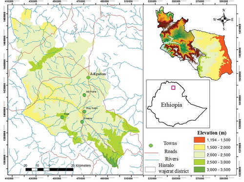
The study area encompasses the central plateau regions of northern Ethiopian which lies between latitudes of 12º 55ʹN to 13º 20ʹN and longitudes of 39º 20ʹE to 39º 55ʹE with elevation ranging from 2000 to 3500 m above sea level (Figure ). The area consists of rolling and undulating plains, medium to high gradient slopes consisting valleys, hills and mountainous landforms. Its land use is mainly subsistence rain-fed agriculture and has a semi-arid climate with mean annual rainfall of 500–850 mm and daily mean temperature of 15–30°C. The lithology comprises mesozoic Antalo limestone, Amba Aradom sandstone, Tertiary basalt and dolerites (Arndt & Menzies, Citation2005; Nyssen et al., Citation2004).
Figure 1. Location of the study area.
2.2. Data collection
Land characteristics influencing rain-fed sorghum production (Table ) were identified based on different literatures and available data. Accordingly, climate, soil and topographic factors mostly taken as critical determinant parameters of land suitability evaluation (Al-Mashreki et al., Citation2011b; Bhagat et al., Citation2009; Guan, Wu, & Carnes, Citation2016; Mesgaran, Madani, Hashemi, & Azadi, Citation2017) were used to determine the overall suitability of the area for that crop. Data needed for land suitability modeling were collected from different sources (Table ). Physical and chemical soil data were collected from laboratory analysis results while environmental and site factors were gathered during field work. Soil characteristics were averaged according to the effective rooting depth (control section) of sorghum which was taken as 1m (FAO, Citation1992). Slope and elevation information was obtained from Topographic maps of 1:50,000 scale and ASTER DEM (Advanced Spaceborne Thermal Emission and Reflection Radiometer) downloaded from Unites States Geological Survey (USGS) databases using different GIS softwares. Climate variables were assembled from national and regional meteorological agencies and then were exported to ArcMap10 and their spatial variability over the area was expressed by using “kriging” interpolation method.
Table 2. Review of papers that used GIS-based MCDM for land suitability evaluation
Table 3. Scale for pair wise comparison in AHP preference (after Saaty, Citation1980)
Table 4. Ranges of factor suitability used for fuzzy membership function for rainfed sorghum
Sorghum is among the major cereal crops grown in Ethiopia accounted for staple food of local people (Kidanu et al., Citation2009; Motuma, Suryabhagavan, & Balakrishnan, Citation2016). It grows in diverse agro-ecologies but adapts well to warm climates worldwide (AbdelRahman et al., Citation2016). It requires 450–650 mm rain and fairly long and frost-free growing season for high rain-fed production (Smith, Citation1997). It is intolerant to low temperature conditions and permits completion of its growing period within the rainy season (FAO, Citation1987c). It needs at least 0.50 m soil depth (Verdoodt & Van Ranst, Citation2003), higher CEC, nutrient and moisture contained clayey soils but asks high fertilizer application when grown in light-textured soils (Naidu, Ramamurthy, Challa, Hegde, & Krishnan, Citation2006) to allow optimal growth. It moderately tolerates drainage, salinity and sodicity and has moderate fertility requirement but asks high workability (FAO, Citation1987c).
2.3. Methods
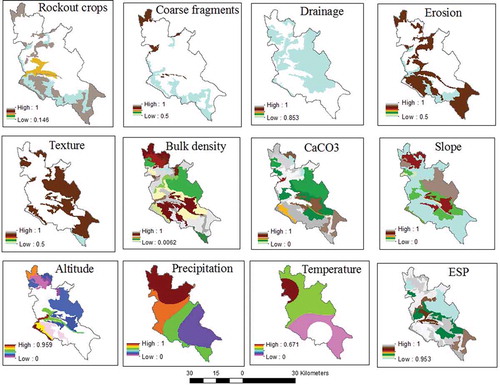
The overall methodology followed in the study is illustrated in Figure . Criteria maps showing the spatial distribution of attributes were constructed based on different GIS functions. Criteria maps showing the spatial distribution of attributes were constructed based on different GIS functions. Fuzzy membership functions which gives more informative results by reducing vagueness and uncertainty (Elaalem, Citation2012) with membership grades ranging from 0 (non-membership) to 1 (complete membership) were used to standardize criteria maps. Higher pixel score indicates a higher suitability level for that pixel. Suitable ranges of the factors that determine the lowest and greatest suitability levels were determined based on different scientific resources (Table ) in order to apply fuzzy membership functions. Standardized factor maps (Figures and ) were accordingly developed using sigmoidal fuzzy membership function (Table ) using the decision support tool of IDRISI software.
Figure 2. Flow chart of the land suitability evaluation for sorghum crop.
Figure 3. Standardized factor maps of criteria used for sorghum suitability.
All criteria were ranked according to their significance following expert opinions and literatures. Accordingly, weights of criteria used for suitability evaluation were obtained using professional experiences of local experts in Hintalo Wajerat district supported by different scientific literatures through pair-wise comparisons following AHP (a widely accepted decision-making method (Eskandari, Homaee, & Mahmodi, Citation2012; Feizizadeh & Blaschke, Citation2013)) in IDRISI software. AHP constructs a pair-wise comparison matrix by assigning values in the range of 1–9 (Table 3) for each factor against every other (Saaty, Citation1980) which finally gives in eigenvector weights indicating the relative importance of the various factors considered (Bagherzadeh & Gholizadeh, Citation2016; Li et al., Citation2017; Saatsaz, Monsef, Rahmani, & Ghods, Citation2018). Consistency ratio (CR) was used to evaluate the degree of consistency of comparison of the factors (Saaty, Citation1977). A CR value of less than 10% was considered acceptable (Brunelli, Citation2014; Liu, Peng, Zhang, & Pedrycz, Citation2017).
After weightings and rating of all criteria over the hierarchy obtained, standardized criteria maps were multiplied with these criteria weights (Ayoade, Citation2017; Romano et al., Citation2015) at each level of the hierarchy by pertaining weighted linear combination (the most common method in MCDA (Malczewski & Rinner, Citation2015)) in order to produce an overall sorghum crop suitability map following the equation below.
, Where: SI = Suitability Index, Wi = weight of factor I, and Xi = normalized criterion score.
The map produced was reclassified as permanently not suitable (<0.2), currently not suitable (0.2–0.4), marginally suitable (0.4–0.6), moderately suitable (0.6–0.8) and highly suitable (>0.8) (FAO, Citation1976, Citation1983; Sys, Van Ranst, & Debaveye, Citation1991).
3. Results and discussion
According to the pair-wise comparison results (Table ), climate, soil and topographic factors were assigned weight values of 0.4126, 0.3275 and 0.2599, respectively. From the climate sub-criteria, length of growing period (0.5396) followed by precipitation (0.2970) got high weight values. Contribution of slope was superior (0.6) over altitude (0.4) from the topographic sub-criteria in relation to sorghum crop production. Among the main soil factors, chemical (0.4434) followed by physical (0.3874) got higher values than site and morphological soil characteristics (which scored weight value of 0.1692). The matrix result indicated that depth (0.2613), erosion (0.2063) and coarse fragments (0.1687) from morphological; texture (0.2894) and bulk density (0.2894) from physical factors and soil organic carbon (0.1941), total nitrogen (0.1217) and available phosphorus (0.1204) from chemical factors were the most important factors for sorghum production. Drainage (0.0496) and consistency (0.0636) followed by soil structure (0.1119); mean weight diameter (0.1750); exchangeable sodium percentage (0.0180), electrical conductivity (0.0248) and calcium carbonate (0.0348) were considered least important from morphological, physical and chemical factors respectively for cultivation of that crop. For sorghum production, the matrix produced CR values ranging between 0.00 and 0.05 indicating that the results were within the 0.1 (the threshold value).
Table 5. Pair-wise comparison matrix for evaluating relative importance of the factors used for suitability evaluation of sorghum crop
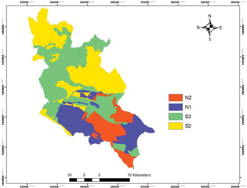
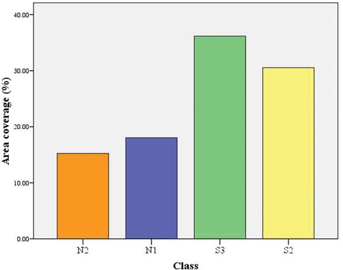
The result of land suitability classification for sorghum is presented in Figure and Table . The area was moderately suitable (29,534.86 ha or 30.54% of it) scattered in the eastern and northwestern parts of the area, marginally suitable (34,984.74 ha/36.17%) concentrated in western, central and partly eastern locations of the area, currently not suitable (17,455.81 ha/18.05%) dominating the south and southwestern portions and permanently not suitable (14,744.61 ha/15.24%) to the south and southeast parts of the area (Table ). Short length of growing period was more serious for that crop. Mean weight diameter, available water capacity, soil organic carbon, total nitrogen and available phosphorus (Figures and ) were below optimum posing very severe limitations. Taking in to account the weights of main and sub-factors. The weights of main and sub-factors (Table 5), overall weight of each factor (Table 6) was calculated by multiplying the weight of main factors and sub-factors.
Table 6. Overall weight of main and sub-criteria for sorghum crop production
Table 7. Area and percentage distribution of suitability classes
Figure 4. Standardized factor maps of criteria used for sorghum suitability.
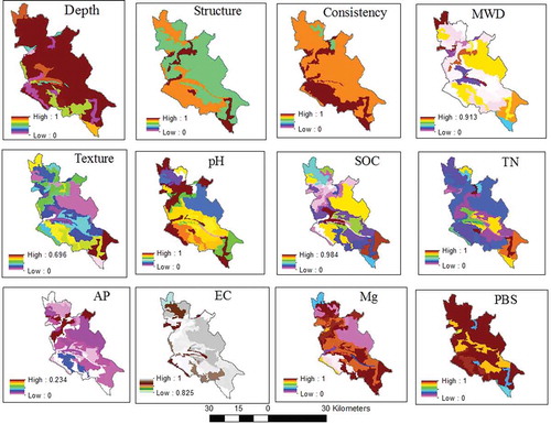
Figure 5. Land suitability map for sorghum.
Moreover, limitations of depth and coarse fragments (western parts of the area), bulk density (southern, eastern and northern parts), magnesium (central, western and north eastern locations) and precipitation (its southern parts) constrained the sorghum production capacity of the area (Figures and ). Altitude and temperature are above optimum level resulting in moderate to severe limitations. Influences of high pH and calcium carbonate were noticeable in the valley floors, plateau and sloping land situated in central and (north) eastern part of the study area. Similarly, Ahmed and Jeb (Citation2014) reported that areas in Bunkure Kano state of Nigeria were moderately suitable to permanently unsuitable for growing sorghum since they exhibited limitations in soil organic carbon, soil depth and rockout crops.
Figure 6. Distribution of suitability classes (by percent area coverage) for rain fed sorghum production.
Low soil organic carbon, total nitrogen, available phosphorus and soil moisture of an agricultural farm in Tanzania (Kaaya, Msanya, & Mrema, Citation1994) limited its suitability for sorghum cultivation. Moreover, rainfall, temperature and calcium carbonate content expressed serious limitations in suitability of micro-water watershed for sorghum production (Mohan, Citation2008). Temperature of Wogdie district in south Wollo of Ethiopia, similarly, was found moderately and marginally suitable for cultivation of the crop (Motuma et al., Citation2016). Sorghum production in western Ethiopia was influenced by shallow depth, limited amounts of total nitrogen, organic carbon and available phosphorus (Yitbarek, Kibret, Gebrekidan, & Beyene, Citation2013). In a study by AbdelRahman et al. (Citation2016), limitations posed by slope grouped the area under moderate suitability for that crop. In support of this result, slope steepness and low soil moisture content were found the major problems influencing agricultural suitability of north western and central Ethiopian highlands (Yalew, Van Griensven, & van der Zaag, Citation2016a).
The study has shown that the area is potential for producing that crop. However, considerable attention should be given to crop selection that best fit the agro-ecology and proper management of the soils in order to get optimum yield.
4. Conclusion
Soil, climate and topographic characteristics were the main criteria used to generate land suitability evaluation for sorghum crop in Enderta dry midlands of northern semi arid highlands, Ethiopia. GIS-based fuzzy AHP model was employed in identifying potential sorghum areas. Soil, climate and topographic criteria were used in the study. According to the land suitability map produced, moderately suitable, marginally suitable, currently not suitable and permanently not suitable lands cover 29,534.86 ha (30.54%), 34,984.74 ha (36.17%), 17,455.81 ha (18.05%) and 14,744.61 ha (15.24%), respectively. Slope gradient, altitude, temperature, length of growing period, available water capacity, mean weight diameter, total nitrogen, available phosphorus and soil organic carbon contents and partly rockout crops, coarse fragments, depth, CaCO3, bulk density and pH were severely limiting the cultivation potential of the area for sorghum crop. It should be noted that careful use of organic and inorganic (acidifying) fertilizers, tillage management, soil and water conservation measures should be taken into consideration in order to maintain soil health and accordingly improve the yield of the crop. Even though climate limitation is difficult to overcome, since the area best suits for very short maturing crop verities (60–90 days Yizengaw (Citation1994)), growing crops which best fit LGP of the area should be taken into consideration. GIS integrated with MCDM analysis was found with great assistance in integrating soil, climate and topographic parameters for land suitability evaluation in the study. The criteria considered for land suitability evaluation were mainly biophysical and, hence, further studies can be made by incorporating socio-economic variables so as to improve the suitability results.
Competing interests
The authors declare no competing interest.
Acknowledgments
Special thanks to the Ethiopian Mistry of Education and Haramaya University for supporting this study. The authors also would like to acknowledge the farmers, agricultural development agents and local administrators of the study area for their field support.
Additional information
Funding
Notes on contributors
Araya Kahsay
Araya Kahsay is a PhD candidate in Soil Science at Haramaya University and lecturer at Natural Resources Management department in Dilla University. His area of focus is GIS for natural resources evaluation and soil pedology. Mitiku Haile is a professor of Soil Science in Mekelle University. His spheres of professional expertise are pedology, soil and water management, hydrology and land-use planning. Girmay Gebresamuel is associate professor of soil and water management in Mekelle University. He carried out several researches on soil quality management, environmental and climate circumstances. Muktar Mohammed, an associate professor of Agroforestry in Oda-Bultum University, is with specialized skills of remote sensing and GIS Application and sustainable agriculture.
References
- Abd-Elmabod, S. K., Jordán, A., Fleskens, L., Phillips, J. D., Muñoz-Rojas, M., van der Ploeg, M., … de La Rosa, D. (2017). Modeling agricultural suitability along soil transects under current conditions and improved scenario of soil factors. In Pereira, P., Brevik, E., Muñoz-Rojas, M., and Miller, B. (Eds.) Soil mapping and process modeling for sustainable land use management (pp. 193–219). Amsterdam, Netherlands: Elsevier.
- AbdelRahman, M. A., Natarajan, A., & Hegde, R. (2016). Assessment of land suitability and capability by integrating remote sensing and GIS for agriculture in Chamarajanagar district, Karnataka, India. The Egyptian Journal of Remote Sensing and Space Science, 19(1), 125–141. doi:10.1016/j.ejrs.2016.02.001
- Abegaz, A., Winowiecki, L. A., Vågen, T. G., Langan, S., & Smith, J. U. (2016). Spatial and temporal dynamics of soil organic carbon in landscapes of the upper blue nile basin of the ethiopian highlands. Agriculture, Ecosystems & Environment, 218, 190–208. doi:10.1016/j.agee.2015.11.019
- Aburas, M. M., Abdullah, S. H., Ramli, M. F., & Asha’ari, Z. H. (2017). Land suitability analysis of urban growth in Seremban Malaysia, using GIS based analytical hierarchy process. Procedia Engineering, 198, 1128–1136. doi:10.1016/j.proeng.2017.07.155
- Ahmed, M., & Jeb, D. N. (2014). Land suitability for sorghum using multicriteria evaluation (MCE) and analytical hierarchy process (AHP) in Bunkure Kano State, Nigeria. Journal of Agriculture and Veterinary Science (IOSRJAVS) e-ISSN, 7(9), 2319–2380.
- Akıncı, H., Özalp, A. Y., & Turgut, B. (2013). Agricultural land use suitability analysis using GIS and AHP technique. Computers and Electronics in Agriculture, 97, 71–82. doi:10.1016/j.compag.2013.07.006
- Al-Mashreki, M. H., Akhir, J. B. M., Rahim, S. A., Kadderi, D. M., Tukimat, L., & Haider, A. R. (2011b). Land suitability evaluation for sorghum crop in the Ibb Governorate, Republic of Yemen using remote sensing and GIS techniques. Australian Journal of Basic and Applied Sciences, 5(3), 359–368.
- Al-Mashreki, M. H., Akhir, J. B. M., Rahim, S. A., Lihan, K. M. D. T., & Haider, A. R. (2011a). GIS-based sensitivity analysis of multi-criteria weights for land suitability evaluation of sorghum crop in the Ibb Governorate Republic of Yemen. Journal of Basic and Applied Scientific Research, 1(9), 1102–1111.
- Arndt, N., & Menzies, M. A. (2005). The ethiopian large igneous province. http://www.largeigneousprovinces.org/print/05jan.
- Ayehu, G. T., & Besufekad, S. A. (2015). Land suitability analysis for rice production: A GIS based multi-criteria decision approach. American Journal of Geographic Information System, 4(3), 95–104.
- Ayoade, M. A. (2017). Suitability assessment and mapping of Oyo State, Nigeria, for rice cultivation using GIS. Theoretical and Applied Climatology, 129(3–4), 1341–1354. doi:10.1007/s00704-016-1852-4
- Bagdanavičiūtė, I., Umgiesser, G., Vaičiūtė, D., Bresciani, M., Kozlov, I., & Zaiko, A. (2018). GIS-based multi-criteria site selection for zebra mussel cultivation: Addressing end-of-pipe remediation of a eutrophic coastal lagoon ecosystem. The Science of the Total Environment, 634, 990–1003. doi:10.1016/j.scitotenv.2018.03.361
- Bagheri, M., Sulaiman, W. N. A., & Vaghefi, N. (2013). Application of geographic information system technique and analytical hierarchy process model for land-use suitability analysis on coastal area. Journal of Coastal Conservation, 17(1), 1–10. doi:10.1007/s11852-012-0213-4
- Bagherzadeh, A., Ghadiri, E., Darban, A. R. S., & Gholizadeh, A. (2016). Land suitability modeling by parametric-based neural networks and fuzzy methods for soybean production in a semi-arid region. Modeling Earth Systems and Environment, 2(2), 104. doi:10.1007/s40808-016-0152-4
- Bagherzadeh, A., & Gholizadeh, A. (2016). Modeling land suitabilit evaluation for wheat production b parametric and TOPSIS approaches using GIS, northeast of Iran. Modeling Earth Systems and Environment, 2(3), 126. doi:10.1007/s40808-016-0177-8
- Beyene, A., Gibbon, D., & Haile, M. (2006). Heterogeneity in land resources and diversity in farming practices in Tigray, Ethiopia. Agricultural Systems, 88(1), 61–74. doi:10.1016/j.agsy.2005.06.004
- Beyene, H. (2008). Adoption of improved Teff and Wheat production technologies in Crop and Livestock mixed systems in Northern and Western Shewa Zones of Ethiopia ( Doctoral dissertation). University of Pretoria, Pretoria.
- Bhagat, R. M., Singh, S., Sood, C., Rana, R. S., Kalia, V., Pradhan, S., … Shrestha, B. (2009). Land suitability analysis for cereal production in Himachal Pradesh (India) using geographical information system. Journal of the Indian Society of Remote Sensing, 37(2), 233. doi:10.1007/s12524-009-0018-6
- Brunelli, M. (2014). Introduction to the analytic hierarchy process (pp. 82). New York, NY: USA, Springer Briefs in Operations Research.
- Buruso, F. H. (2018). Habitat suitability analysis for hippopotamus (H. amphibious) using GIS and remote sensing in Lake Tana and its environs, Ethiopia. Environmental Systems Research, 6(1), 6. doi:10.1186/s40068-017-0083-8
- Chamberlin, J., Jayne, T. S., & Headey, D. (2014). Scarcity amidst abundance? Reassessing the potential for cropland expansion in Africa. Food Policy, 48, 51–65. doi:10.1016/j.foodpol.2014.05.002
- Cowie, A. L., Orr, B. J., Sanchez, V. M. C., Chasek, P., Crossman, N. D., Erlewein, A., … Tengberg, A. E. (2018). Land in balance: The scientific conceptual framework for land degradation neutrality. Environmental Science & Policy, 79, 25–35. doi:10.1016/j.envsci.2017.10.011
- Davis, B., Di Giuseppe, S., & Zezza, A. (2017). Are African households (not) leaving agriculture? Patterns of households’ income sources in rural Sub-Saharan Africa. Food Policy, 67, 153–174. doi:10.1016/j.foodpol.2016.09.018
- Deininger, K., & Byerlee, D. (2011). Rising global interest in farmland: Can it yield sustainable and equitable benefits? Washington, DC: World Bank Publications.
- Dell’Ovo, M., Capolongo, S., & Oppio, A. (2018). Combining spatial analysis with MCDA for the siting of healthcare facilities. Land Use Policy, 76, 634–644. doi:10.1016/j.landusepol.2018.02.044
- Din, G. Y., & Yunusova, A. B. (2016). Using AHP for evaluation of criteria for agro-industrial projects. International Journal of Horticulture & Agriculture, 1(1), 6.
- Diop, A., Ndiaye, M. L., Sambou, H., Dacosta, H., & Sambou, B. (2017). Integrated a GIS and multicriteria evaluation approach for mapping flood vulnerability of buildings in the Grande Niaye Watershed of Dakar, Senegal. American Journal of Geographic Information System, 6(2), 41–53.
- Duc, T. T. (2006, November). Using GIS and AHP technique for land-use suitability analysis. In International symposium on geoinformatics for spatial infrastructure development in earth and allied sciences (pp. 1–6). Vietnam: Ho Chi Minh.
- Elaalem, M. (2012). Land suitability evaluation for sorghum based on boolean and fuzzy-multi-criteria decision analysis methods. International Journal of Environmental Science and Development, 3(4), 357–361. doi:10.7763/IJESD.2012.V3.247
- Elaalem, M., Comber, A., & Fisher, P. (2011). A comparison of fuzzy AHP and ideal point methods for evaluating land suitability. Transactions in GIS, 15(3), 329–346. doi:10.1111/j.1467-9671.2011.01260.x
- Eskandari, M., Homaee, M., & Mahmodi, S. (2012). An integrated multi criteria approach for landfill siting in a conflicting environmental, economical and socio-cultural area. Waste Management, 32(8), 1528–1538. doi:10.1016/j.wasman.2012.03.014
- FAO. (1976). A framework for land evaluation. Soils Bulletin No. 32, Food and Agriculture Organization of the United Nations, Rome, Italy.
- FAO. (1983). Guidelines: land evaluation for rain fed agriculture. FAO Soils Bulletin No. 52, Author, Rome.
- FAO. (1987a). Land Evaluation and recommendations for land use planning in the Borkena study area (Welo/Shewa). AG/DP/ETH/82/010, Field Document No.18. Author.
- FAO. (1987b). Land Evaluation and recommendations for land use planning in the Bichena study area (Gojjam). AG: DP/ETH/82/010 Field Document No. 19. Author.
- FAO. (1987c). Manual on a computerized land evaluation system for Ethiopia with special reference to the highlands of Ethiopia: volume ii: the influence of environmental conditions on plant growth and development. AG: DP/ETH/82/010, Field Document No. 17. Author.
- FAO. (1988). A summary of the agricultural ecology of Ethiopia. Prepared under FAO projects Food Information Systems (GCPS/ETH/044/NOR), Zonation and Calibration for Project Planning (TCP/ETH/6658), Master Land Use Plan (ETH/82/010), FAO, Rome. doi:10.3168/jds.S0022-0302(88)79586-7
- FAO. (1992). Crop water requirements. FAO irrigation and drainage paper 24.
- FAO. (1993). Guidelines for land-use planning (Vol. 1). FAO Development Series 1.
- FAO. (2009, October). How to Feed the World in 2050. Paper prepared for the high level expert forum. Author, Rome. http://www.fao.org/fileadmin/templates/wsfs/docs/expert_paper/How_to_Feed_the_World_in_2050.pdf.
- Feizizadeh, B., & Blaschke, T. (2012). Land suitability analysis for Tabriz County, Iran: A multi-criteria evaluation approach using GIS. Journal of Environmental Planning and Management, 56(1), 1–23. doi:10.1080/09640568.2011.646964
- Feizizadeh, B., & Blaschke, T. (2013). GIS-multicriteria decision analysis for landslide susceptibility mapping: Comparing three methods for the Urmia lake basin, Iran. Natural Hazards, 65(3), 2105–2128. doi:10.1007/s11069-012-0463-3
- Gebreselassie, S., Kirui, O. K., & Mirzabaev, A. (2016). Economics of land degradation and improvement in Ethiopia. In E. Nkonya, A. Mirzabaev, & J. Von Braun (Eds.), Economics of land degradation and improvement–A global assessment for sustainable development (pp. 401–430). Cham: Springer.
- Gigović, L., Pamučar, D., Bajić, Z., & Drobnjak, S. (2017). Application of GIS-interval rough AHP methodology for flood hazard mapping in urban areas. Water, 9(6), 360. doi:10.3390/w9060360
- Gigović, L., Pamučar, D., Božanić, D., & Ljubojević, S. (2017). Application of the GIS-DANP-MABAC multi-criteria model for selecting the location of wind farms: A case study of Vojvodina, Serbia. Renewable Energy, 103, 501–521. doi:10.1016/j.renene.2016.11.057
- Gigović, L., Pamučar, D., Lukić, D., & Marković, S. (2016). GIS-Fuzzy DEMATEL MCDA model for the evaluation of the sites for ecotourism development: A case study of “Dunavski ključ” region, Serbia. Land Use Policy, 58, 348–365. doi:10.1016/j.landusepol.2016.07.030
- Grafton, R. Q., Daugbjerg, C., & Qureshi, M. E. (2015). Towards food security by 2050. Food Security, 7(2), 179–183. doi:10.1007/s12571-015-0445-x
- Greene, R., Devillers, R., Luther, J. E., & Eddy, B. G. (2011). GIS‐based multiple‐criteria decision analysis. Geography Compass, 5(6), 412–432. doi:10.1111/j.1749-8198.2011.00431.x
- Guan, W. W., Wu, K., & Carnes, F. (2016). Modeling spatiotemporal pattern of agriculture‐feasible land in China. Transactions in GIS, 20(3), 426–447. doi:10.1111/tgis.2016.20.issue-3
- Hadgu, G., Tesfaye, K., & Mamo, G. (2015). Analysis of climate change in Northern Ethiopia: Implications for agricultural production. Theoretical and Applied Climatology, 121(3–4), 733–747. doi:10.1007/s00704-014-1261-5
- Harper, M., Anderson, B., James, P., & Bahaj, A. (2017, July). Identifying suitable locations for onshore wind turbines using a GIS-MCDA approach. In: the 17th International conference on sustainable energy technologies. Bologna, Italy.
- Hegde, R., Niranjana, K. V., Natarajan, A., & Naidu, L. G. K. (2012, January). Efficient techniques for detailed land resources inventorization using remote sensing and conventional tools: A case study of Tirumale sub-watershed in Magadi Taluk, Karnataka. In Prabhuraj, D. K., Reddy, R.S., Murthy, T.R.S., Vadivelu, S., Bakre, S.S., Prathima, K., Brunda, D.D., & Priya, H. (Eds.). National seminar on geospatial solutions for resource conservation and management (pp. 1–16). Bengaluru, India.
- Hossain, M. S., & Das, N. G. (2010). GIS-based multi-criteria evaluation to land suitability modelling for giant prawn (Macrobrachium rosenbergii) farming in Companigonj Upazila of Noakhali, Bangladesh. Computers and Electronics in Agriculture, 70(1), 172–186. doi:10.1016/j.compag.2009.10.003
- Houshyar, E., Smith, P., Mahmoodi-Eshkaftaki, M., & Azadi, H. (2017). Sustainability of wheat production in Southwest Iran: A fuzzy-GIS based evaluation by ANFIS. Cogent Food & Agriculture, 3(1), 1327682. doi:10.1080/23311932.2017.1327682
- IAO, 2008. Land evaluation in Enderta district-Tigray region, Ethiopia. 28th course professional master in Geomatics and Natural resources evaluation. Istituto Agronomico per l’Oltremare, pp. 241.
- IIASA/FAO. (2012). Global agro-ecological zones–model documentation (GAEZ v. 3.0). Laxenburg, Austria & Rome, Italy: International Institute of Applied Systems Analysis & Food and Agricultural Organization.
- Jiao, S., Zhang, X., & Xu, Y. (2017). A review of Chinese land suitability assessment from the rainfall-waterlogging perspective: Evidence from the Su Yu Yuan area. Journal of Cleaner Production, 144, 100–106. doi:10.1016/j.jclepro.2016.12.162
- Kaaya, A. K., Msanya, B. M., & Mrema, J. P. (1994). Soils and land evaluation of part of the Sokoine University of agriculture farm (Tanzania) for some crops under rainfed conditions. African Study Monographs, 15(2), 97–117.
- Kamkar, B., Dorri, M. A., & da Silva, J. A. T. (2014). Assessment of land suitability and the possibility and performance of a canola (Brassica napus L.)-soybean (Glycine max L.) rotation in four basins of Golestan province, Iran. The Egyptian Journal of Remote Sensing and Space Science, 17(1), 95–104. doi:10.1016/j.ejrs.2013.12.001
- Karlen, D. L., & Rice, C. W. (2015). Soil degradation: Will humankind ever learn? Sustainability, 7, 12490–12501. doi:10.3390/su70912490
- Kazemi, H., & Akinci, H. (2018). A land use suitability model for rainfed farming by multi-criteria decision-making analysis (MCDA) and geographic information system (GIS). Ecological Engineering, 116, 1–6. doi:10.1016/j.ecoleng.2018.02.021
- Kazemi, H., Sadeghi, S., & Akinci, H. (2016). Developing a land evaluation model for faba bean cultivation using geographic information system and multi-criteria analysis (A case study: Gonbad-Kavous region, Iran). Ecological Indicators, 63, 37–47. doi:10.1016/j.ecolind.2015.11.021
- Kebede, F. (2002). Analysis of yield gap for wheat cultivation in the highlands of North Ethiopia ( Doctoral dissertation). Gent University, Belgium. doi:10.1044/1059-0889(2002/er01)
- Keesstra, S. D., Bouma, J., Wallinga, J., Tittonell, P., Smith, P., Cerdà, A., … Bardgett, R. D. (2016). The significance of soils and soil science towards realization of the united nations sustainable development goals. Soil, 2(2), 111–128. doi:10.5194/soil-2-111-2016
- Kidanu, S., Kindu, M., & Chernet, T. (2009). GIS-based agricultural land suitability for target crops. Ethiopian Institute of Agricultural Research, research report, pp.23.
- Lal, R. (1994). Methods and guidelines for assessing sustainable use of soil and water resources in the tropics. Washington, US: Soil Management Support Services.
- Li, Q., Huang, J., Wang, C., Lin, H., Zhang, J., Jiang, J., & Wang, B. (2017). Land development suitability evaluation of Pingtan island based on scenario analysis and landscape ecological quality evaluation. Sustainability, 9(7), 1292. doi:10.3390/su9071292
- Liu, F., Peng, Y., Zhang, W., & Pedrycz, W. (2017). On consistency in AHP and Fuzzy AHP. Journal of Systems Science and Information, 5(2), 128–147.
- Liu, Y., Jiao, L., Liu, Y., & He, J. (2013). A self-adapting fuzzy inference system for the evaluation of agricultural land. Environmental Modelling & Software, 40, 226–234. doi:10.1016/j.envsoft.2012.09.013
- Malczewski, J., & Rinner, C. (2015). Multicriteria decision analysis in geographic information science (pp. 331). New York, NY: USA. Springer Science.
- Maleki, F., Kazemi, H., Siahmarguee, A., & Kamkar, B. (2017). Development of a land use suitability model for saffron (Crocus sativus L.) cultivation by multi-criteria evaluation and spatial analysis. Ecological Engineering, 106, 140–153. doi:10.1016/j.ecoleng.2017.05.050
- Malmir, M., Zarkesh, M. M. K., Monavari, S. M., Jozi, S. A., & Sharifi, E. (2016). Analysis of land suitability for urban development in Ahwaz County in southwestern Iran using fuzzy logic and analytic network process (ANP). Environmental Monitoring and Assessment, 188(8), 447. doi:10.1007/s10661-016-5401-5
- McKenzie, F. C., & Williams, J. (2015). Sustainable food production: Constraints, challenges and choices by 2050. Food Security, 7(2), 221–233. doi:10.1007/s12571-015-0441-1
- Meaza, H., Frankl, A., Poesen, J., Zenebe, A., Deckers, J., Van Eetvelde, V., … Nyssen, J. (2017). Natural resource opportunities and challenges for rural development in marginal grabens–The state of the art with implications for the rift valley system in Ethiopia. Journal of Arid Environments, 147, 1–16. doi:10.1016/j.jaridenv.2017.08.003
- Mekuriaw, A. (2017). Assessing the effectiveness of land resource management practices on erosion and vegetative cover using GIS and remote sensing techniques in Melaka watershed, Ethiopia. Environmental Systems Research, 6(1), 16. doi:10.1186/s40068-017-0093-6
- Mendas, A., & Delali, A. (2012). Integration of multicriteria decision analysis in GIS to develop land suitability for agriculture: Application to durum wheat cultivation in the region of Mleta in Algeria. Computers and Electronics in Agriculture, 83, 117–126. doi:10.1016/j.compag.2012.02.003
- Mesgaran, M. B., Madani, K., Hashemi, H., & Azadi, P. (2017). Iran’s land suitability for agriculture. Scientific Reports, 7(1), 7670. doi:10.1038/s41598-017-08066-y
- Mighty, M. A. (2015). Site suitability and the analytic hierarchy process: How GIS analysis can improve the competitive advantage of the Jamaican coffee industry. Applied Geography, 58, 84–93. doi:10.1016/j.apgeog.2015.01.010
- Mishra, A. K., Deep, S., & Choudhary, A. (2015). Identification of suitable sites for organic farming using AHP & GIS. The Egyptian Journal of Remote Sensing and Space Science, 18(2), 181–193. doi:10.1016/j.ejrs.2015.06.005
- Mohan, M. M. (2008). Characterization and classification of sols and land suitability of a micro-watershed in Hanagal taluk ( Master’s thesis). UAS, Dharwad.
- Mosadeghi, R., Warnken, J., Tomlinson, R., & Mirfenderesk, H. (2015). Comparison of Fuzzy-AHP and AHP in a spatial multi-criteria decision making model for urban land-use planning. Computers, Environment and Urban Systems, 49, 54–65. doi:10.1016/j.compenvurbsys.2014.10.001
- Motuma, M., Suryabhagavan, K. V., & Balakrishnan, M. (2016). Land suitability analysis for wheat and sorghum crops in Wogdie District, South Wollo, Ethiopia, using geospatial tools. Applied Geomatics, 8(1), 57–66. doi:10.1007/s12518-016-0168-5
- Mousavi, S. R., Sarmadian, F., Alijani, Z., & Taati, A. (2017). Land suitability evaluation for irrigating wheat by geopedological approach and geographic information system: A case study of Qazvin plain, Iran. Eurasian Journal of Soil Science, 6(3), 275–284.
- Musakwa, W. (2017). Identifying land suitable for agricultural land reform using GIS-MCDA in South Africa. Environment, Development and Sustainability, 1–19. doi:10.1007/s10668-017-9989-6
- Mustafa, A. A., Singh, M., Sahoo, R. N., Ahmed, N., Khanna, M., Sarangi, A., & Mishra, A. K. (2011). Land suitability analysis for different crops: A multi criteria decision making approach using remote sensing and GIS. Researcher, 3(12), 61–84.
- Naidu, L. G. K., Ramamurthy, V., Challa, O., Hegde, R., & Krishnan, P. (2006). Manual soil-site suitability criteria for major crops. Amravati, Road, Nagpu, India: National Bureau of Soil Survey and Land Use Planning (I CAR).
- Nedeco, N., 1997. Tekeze river basin integrated development master plan project. Second phase report vol. NR. 2-Soils and terrain.
- Negusse, T., Yazew, E., & Tadesse, N. (2013). Quantification of the impact of integrated soil and water conservation measures on groundwater availability in Mendae Catchment, Abraha We-Atsebaha, eastern Tigray, Ethiopia. Momona Ethiopian Journal of Science, 5(2), 117–136.
- Nyssen, J., Frankl, A., Zenebe, A., Deckers, J., & Poesen, J. (2015). Land management in the northern Ethiopian highlands: Local and global perspectives; past, present and future. Land Degradation & Development, 26(7), 759–764. doi:10.1002/ldr.2336
- Nyssen, J., Poesen, J., Moeyersons, J., Deckers, J., Haile, M., & Lang, A. (2004). Human impact on the environment in the Ethiopian and Eritrean highlands-a state of the art. Earth-Science Reviews, 64(3–4), 273–320. doi:10.1016/S0012-8252(03)00078-3
- Otgonbayar, M., Atzberger, C., Chambers, J., Amarsaikhan, D., Böck, S., & Tsogtbayar, J. (2017). Land suitability evaluation for agricultural cropland in Mongolia using the spatial MCDM method and AHP based GIS. Journal of Geoscience and Environment Protection, 5(09), 238–263. doi:10.4236/gep.2017.59017
- Owusu, S., Mul, M. L., Ghansah, B., Osei-Owusu, P. K., Awotwe-Pratt, V., & Kadyampakeni, D. (2017). Assessing land suitability for aquifer storage and recharge in northern Ghana using remote sensing and GIS multi-criteria decision analysis technique. Modeling Earth Systems and Environment, 3, 1383–1393. doi:10.1007/s40808-017-0360-6
- Pamučar, D., Gigović, L., Bajić, Z., & Janošević, M. (2017). Location selection for wind farms using GIS multi-criteria hybrid model: An approach based on fuzzy and rough numbers. Sustainability, 9(8), 1315. doi:10.3390/su9081315
- Pender, J., Place, F., & Ehui, S. (Eds.). (2006). Strategies for sustainable land management in the East African highlands. Washington, DC: Intl Food Policy Res Inst.
- Pichaimani, V., & Manjula, K. R. (2016). Research directions on GIS database design and management. Indian Journal of Science and Technology, 9, 39. doi:10.17485/ijst/2016/v9i39/92774
- Popp, J., Lakner, Z., Harangi-Rakos, M., & Fari, M. (2014). The effect of bioenergy expansion: Food, energy, and environment. Renewable and Sustainable Energy Reviews, 32, 559–578. doi:10.1016/j.rser.2014.01.056
- Prakash, T. N. (2003). Land suitability analysis for agricultural crops: a fuzzy multicriteria decision making approach. ITC (Master’s thesis). Retrieved from: https://webapps.itc.utwente.nl/librarywww/papers_2003/msc/gfm/prakash.pdf.
- Pramanik, M. K. (2016). Site suitability analysis for agricultural land use of Darjeeling district using AHP and GIS techniques. Modeling Earth Systems and Environment, 2(2), 56. doi:10.1007/s40808-016-0116-8
- Purnamasari, R. A., Ahamed, T., & Noguchi, R. (2018). Land suitability assessment for cassava production in Indonesia using GIS, remote sensing and multi-criteria analysis. Asia-Pacific Journal of Regional Science, 2(1), 1–32.
- Qureshi, M. R. N., Singh, R. K., & Hasan, M. A. (2018). Decision support model to select crop pattern for sustainable agricultural practices using fuzzy MCDM. Environment, Development and Sustainability, 20(2), 641–659. doi:10.1007/s10668-016-9903-7
- Rad, L. K., & Haghyghy, M. (2014). Integrated analytical hierarchy process (AHP) and GIS for land use suitability analysis. World Applied Sciences Journal, 32(4), 587–594.
- Raza, S. M. H., Mahmood, S. A., Khan, A. A., & Liesenberg, V. (2018). Delineation of potential sites for rice cultivation through multi-criteria evaluation (MCE) using remote sensing and GIS. International Journal of Plant Production, 12(1), 1–11. doi:10.1007/s42106-017-0001-z
- Ristić, V., Maksin, M., Nenković-Riznić, M., & Basarić, J. (2018). Land-use evaluation for sustainable construction in a protected area: A case of Sara mountain national park. Journal of Environmental Management, 206, 430–445. doi:10.1016/j.jenvman.2017.09.080
- Robinson, L. W., Ericksen, P. J., Chesterman, S., & Worden, J. S. (2015). Sustainable intensification in drylands: What resilience and vulnerability can tell us? Agricultural Systems, 135, 133–140. doi:10.1016/j.agsy.2015.01.005
- Romano, G., Dal Sasso, P., Liuzzi, G. T., & Gentile, F. (2015). Multi-criteria decision analysis for land suitability mapping in a rural area of Southern Italy. Land Use Policy, 48, 131–143. doi:10.1016/j.landusepol.2015.05.013
- Roy, J., & Saha, S. (2018). Assessment of land suitability for the paddy cultivation using analytical hierarchical process (AHP): A study on Hinglo river basin, Eastern India. Modeling Earth Systems and Environment, 4(2), 1–18.
- Saatsaz, M., Monsef, I., Rahmani, M., & Ghods, A. (2018). Site suitability evaluation of an old operating landfill using AHP and GIS techniques and integrated hydrogeological and geophysical surveys. Environmental Monitoring and Assessment, 190(3), 144. doi:10.1007/s10661-018-6505-x
- Saaty, T. (1980). The analytical hierarchy process, planning priority. Resource Allocation, TWS Publications. USA, 287.
- Saaty, T. L. (1977). A scaling method for priorities in hierarchical structures. Journal of Mathematical Psychology, 15(3), 234–281. doi:10.1016/0022-2496(77)90033-5
- Sahu, N., Reddy, G. O., Kumar, N., & Nagaraju, M. S. S. (2015). High resolution remote sensing, GPS and GIS in soil resource mapping and characterization-A review. Agricultural Reviews, 36(1), 14–25. doi:10.5958/0976-0741.2015.00002.1
- Scherer, L. A., Verburg, P. H., & Schulp, C. J. E. (2018). Opportunities for sustainable intensification in European agriculture. Global Environmental Change, 48, 43–55. doi:10.1016/j.gloenvcha.2017.11.009
- Seleshi, Y., & Camberlin, P. (2006). Recent changes in dry spell and extreme rainfall events in Ethiopia. Theoretical and Applied Climatology, 83(1–4), 181–191.
- Seyedmohammadi, J., Sarmadian, F., Jafarzadeh, A. A., Ghorbani, M. A., & Shahbazi, F. (2018). Application of SAW, TOPSIS and fuzzy TOPSIS models in cultivation priority planning for maize, rapeseed and soybean crops. Geoderma, 310, 178–190.
- Singh, L. K., Jha, M. K., & Chowdary, V. M. (2017). Multi-criteria analysis and GIS modeling for identifying prospective water harvesting and artificial recharge sites for sustainable water supply. Journal of Cleaner Production, 142, 1436–1456.
- Singha, C., & Swain, K. C. (2016). Land suitability evaluation criteria for agricultural crop selection: A review. Agricultural Reviews, 37(2), 125–132.
- Smith, J. M. B. (1997). Crop, pasture and timber yield estimates for KwaZulu-Natal ( Cedara Report No. N/A/97/9). KwaZulu-Natal Department of Agriculture, Cedara.
- Sys, C., Van Ranst, B., & Debaveye, J., 1993. Land evaluation. Part II: Methods in land evaluation. Agriculturala publication No. 7. International training center for post graduate soil scientists, University Ghent, Belgium.
- Sys, C., Van Ranst, E., & Debaveye, J. (1991). Land evaluation. Part II: Method of land evaluation. General administration for development cooperation, International training center for post graduate soil scientists. University GHENT, Brussels, Belgium. Agric Publication No. 7:1–265.
- Tesfaye, S., Birhane, E., Leijnse, T., & van der Zee, S. E. A. T. M. (2017). Climatic controls of ecohydrological responses in the highlands of northern Ethiopia. Science of the Total Environment, 609, 77–91.
- Tomić, H., Mastelić Ivić, S., & Roić, M. (2018). Land consolidation suitability ranking of cadastral municipalities: Information-based decision-making using multi-criteria analyses of official registers’ data. ISPRS International Journal of Geo-Information, 7(3), 87.
- Torrieri, F., & Batà, A. (2017). Spatial multi-criteria decision support system and strategic environmental assessment: A case study. Buildings, 7(4), 96.
- Tóth, G., Jones, A., & Montanarella, L. (2013). The LUCAS topsoil database and derived information on the regional variability of cropland topsoil properties in the European Union. Environmental Monitoring and Assessment, 185(9), 7409–7425.
- Van Chuong, H. (2008, December). Multicriteria land suitability evaluation for crops using GIS at community level in central vietnam. In International Symposium on geoinformatics for spatial-infrastructure development in earth and allied sciences. Hanoi, Vietnam.
- Van Ittersum, M. K., Van Bussel, L. G., Wolf, J., Grassini, P., Van Wart, J., Guilpart, N., … Yang, H. (2016). Can sub-Saharan Africa feed itself? Proceedings of the National Academy of Sciences, 113(52), 14964–14969.
- Van Orshoven, J., Terres, J. M., & Tóth, T., 2014. Updated common bio-physical criteria to define natural constraints for agriculture in Europe. JRC Scientific and Technical Report, European Commission Joint Research Centre Institute for Environment and Sustainability-IES, Luxemburg.
- Vanmaercke, M., Zenebe, A., Poesen, J., Nyssen, J., Verstraeten, G., & Deckers, J. (2010). Sediment dynamics and the role of flash floods in sediment export from medium-sized catchments: A case study from the semi-arid tropical highlands in northern Ethiopia. Journal of Soils and Sediments, 10(4), 611–627.
- Verdoodt, A., & Van Ranst, E. (2003). Land evaluation for agricultural production in the tropics: A large-scale land suitability classification for Rwanda. Ghent University. Laboratory of Soil Science, Krijgslaan 281 S8, B-9000 Gent, Belgium.
- Walke, N., Reddy, G. O., Maji, A. K., & Thayalan, S. (2012). GIS-based multicriteria overlay analysis in soil-suitability evaluation for cotton (Gossypium spp.): A case study in the black soil region of Central India. Computers & Geosciences, 41, 108–118.
- Wijenayake, W. K., Amarasinghe, U. S., & De Silva, S. S. (2016). Application of a multiple-criteria decision making approach for selecting non-perennial reservoirs for culture-based fishery development: Case study from Sri Lanka. Aquaculture, 459, 26–35.
- Worqlul, A. W., Jeong, J., Dile, Y. T., Osorio, J., Schmitter, P., Gerik, T., … Clark, N. (2017). Assessing potential land suitable for surface irrigation using groundwater in Ethiopia. Applied Geography, 85, 1–13.
- Xu, E., & Zhang, H. (2013). Spatially-explicit sensitivity analysis for land suitability evaluation. Applied Geography, 45, 1–9.
- Yalew, S. G., van Griensven, A., Mul, M. L., & van der Zaag, P. (2016b). Land suitability analysis for agriculture in the Abbay basin using remote sensing, GIS and AHP techniques. Modeling Earth Systems and Environment, 2(2), 101.
- Yalew, S. G., Van Griensven, A., & van der Zaag, P. (2016a). AgriSuit: A web-based GIS-MCDA framework for agricultural land suitability assessment. Computers and Electronics in Agriculture, 128, 1–8.
- Yebo, B. (2015). Integrated soil fertility management for better crop production in Ethiopia. International Journal of Soil Science, 10(1), 1–16.
- Yitbarek, T., Kibret, K., Gebrekidan, H., & Beyene, S. (2013). Physical land suitability evaluation for rainfed production of cotton, maize, upland rice and sorghum in Abobo Area, western Ethiopia. American Journal of Research Communication, 1(10), 296–318.
- Yizengaw, T. (1994). An approach towards a macro-scale land evaluation as a basis to identify resource management options in Central Ethiopia ( Doctoral dissertation). Univ. Gent, Belgium.
- You, L., Ringler, C., Wood-Sichra, U., Robertson, R., Wood, S., Zhu, T., … Sun, Y. (2011). What is the irrigation potential for Africa? A combined biophysical and socioeconomic approach. Food Policy, 36(6), 770–782.
- Young, A. (2000). Land resources: Now and for the future. Cambridge University Press, Cambridge, UK.
- Yu, Y., Shi, L., Huai, H., & Li, C. (2013, September). Study on the application of information technologies on suitability evaluation analysis in agriculture. In Li, D. and Chen, Y. (Eds.). International conference on computer and computing technologies in agriculture (pp. 165–176). Berlin, Heidelberg: Springer.
- Zabihi, H., Ahmad, A., Vogeler, I., Said, M. N., Golmohammadi, M., Golein, B., & Nilashi, M. (2015). Land suitability procedure for sustainable citrus planning using the application of the analytical network process approach and GIS. Computers and Electronics in Agriculture, 117, 114–126.
- Zavadskas, E. K., Stević, Ž., Tanackov, I., & Prentkovskis, O. (2018). A novel multicriteria approach–rough step-wise weight assessment ratio analysis method (R-SWARA) and its application in logistics. Studies in Informatics and Control, 27(1), 97–106.
- Zhang, J., Su, Y., Wu, J., & Liang, H. (2015). GIS based land suitability assessment for tobacco production using AHP and fuzzy set in Shandong province of China. Computers and Electronics in Agriculture, 114, 202–211.
- Zhang, K., & Achari, G. (2010). Uncertainty propagation in environmental decision making using random sets. Procedia Environmental Sciences, 2, 576–584.
- Zolekar, R. B., & Bhagat, V. S. (2015). Multi-criteria land suitability analysis for agriculture in hilly zone: Remote sensing and GIS approach. Computers and Electronics in Agriculture, 118, 300–321.