
Abstract
Urban forests are one of the crucial ecosystems for sustainability, by which they provide carbon sequestration, microclimate regulation, recreation and other ecosystem services. Despite the profound benefits obtained, anthropogenic disturbances are hindering its development. On the other hand, to ensure the livability of urban areas, communities and governments have been putting efforts in managing urban forests. Although, a huge amount of labor is invested in enhancing the urban vegetation cover of Endayesus area, it is not clear to what extent it succeeded or failed over years. Based on that, this paper aimed to detect forest cover change and contribution of forestry practices in enhancing forest cover of Endayesus urban forest area. Aerial photos were obtained from Ethiopian mapping agency and planning office of Mekele city. Other data were collected from randomly selected 196 sample households and purposively selected 20 officials using questionnaire and interview checklists. SPSS and GIS software were used for analysis and generating figurative and spatial outputs. Analysis was carried out using descriptive statistics. The study confirmed forest cover in Endayesus increased by 1387.43% from 1965 to 2009. However, the existence of bare and bushland use types exist substantially. Enclosing the catchment, plantations, public education and tree management activities contributed in improving forest cover of the area. There should have to be a land cover/use plan prepared in a way to maximize the benefits of urban forests within the area based on established multiple criteria. In addition, further research is needed in modeling the possible damage to Mekele city under vegetated and non-vegetated scenarios of Endayesus area in different climatic conditions.
PUBLIC INTEREST STATEMENT
The research was conducted to understand if forest cover is being changed over time and forestry activities have an impact on the change in Endayesus area of Mekele, Tigray, Ethiopia. The study area is sloppy by which many residents and their socioeconomic activities are found down the catchment. Therefore, it is a kind of place which needs various natural conservation activities (including forest management) to safeguard the community down of it. Considering such issues this paper highlights the success/failure of the investments done over years by the local government to enhance vegetation cover of the area. The information obtained from the findings will be helpful for local governments, which will enable them to revise their strategies in a way to make urban forestry more successful.
Competing Interests
The author declares no competing interests.
1. Introduction
Because of improper utilization, land resources are degrading fast creating high pressure and slowing down the effort to achieve sustainable development goals (Keesstra et al., Citation2016; Keesstra et al., Citation2018). Land degradation can be avoided by multifunctional utilization of land. Scholars introduced four approaches, namely; systems thinking, connectivity, nature-based solutions and regenerative economics by which realize land degradation neutrality. These approaches bring sustainable solutions from an economic, environmental and social point of view (Keesstra et al., Citation2018). One of the nature-based solutions is managing urban forests.
Starting from the beginning of the twenty-first century, one of the major issues in sustainable land management is the relationship between towns and forests (FAO, Citation2012) It is believed that green infrastructures provide equal benefit as gray infrastructure to a city; but communities promoting green infrastructure are more livable; producing fewer pollutants and cost-effective to operate (FAO, Citation2012). Urban forests enable to get benefits of commercial product (Chiras, Citation2013), local climate regulation, energy use, air quality improvement, climate change mitigation, noise abatement, home for wildlife and biodiversity, etc. In addition to all its ecosystem services, well-managed urban forest is an important tool for reducing stormwater runoff by slowing time to peak runoff and reducing the volumes of those peak flows (Nowak et al., Citation2010) and trapping sediment load from an upper catchment (Mekonnen, Keesstra, Baartman, Stroosnijder, & Maroulis, Citation2017).
Despite the various benefits obtained from urban forests and other natural ecosystems (Chiras, Citation2013), it is observed less emphasis is given by neglecting the role we could obtain from them (Locatelli, Citation2015). Urban growth is resulting high burden on natural areas, waterways, increased road and traffic problems, waste related problems and disturbance from intensive recreation and tourism (Bekessy & Gordon, Citation2007). As urban expansion continues, challenges are likely to increase and new ones might emerge (Nowak et al., Citation2010). There are evidences that urban areas are affecting vegetation areas near and within them. For instance, the conversion of vegetated land to human uses in watersheds of Nairobi city has a negative impact on urban biodiversity (Bosco, Geoffrey, & Kariuki, Citation2011). Besides, in West Africa, urban expansion, land scarcity and poor implementation of government policies are some factors affecting urban forest development (Fuwape & Onyekwelu, Citation2011).
When forests near residential areas and cities are degraded, the forest functions of regulating water flows, preventing landslides, floods and droughts in the nearby downstream areas are lost. This could lead high cost to the community in terms of human life loose, infrastructure destruction, island heat effect and water supply shortage (FAO, Citation2012). For example, a study conducted in the central rift valley of Ethiopia confirms that a long-term decline in forest and woodland cover causes the temperature to rise (Muluneh et al., Citation2017) thereby escalate the certain climate change impacts (Muluneh, Stroosnijder, Keesstra, & Biazin, Citation2017).
Globally forests cover almost more than a quarter of the Earth’s land surface, estimated approximately 4.2 Billion hectares (Chiras, Citation2013).Reports show Ethiopia’s forest cover is 12.2 million ha (11%) (FAO, Citation2012; Moges, Eshetu, & Nune, Citation2010). If we see in Ethiopia of Addis Ababa, the area covered by forest, mostly eucalyptus is 7,734 ha. This is about 15% of the total area covered by Addis Ababa, but only 35% of the planned green border of the city (Yan et al., Citation2010).
A research in selected areas of Tigray (North Ethiopia) proves that woody vegetation and built up area increased strongly, which mostly occurred at the expense of bushland (Meire et al., Citation2013). On the contrary, based on the research in land cover analysis of Mekele, sparse forest showed no changeover years. It was also noted that urban features in Mekele increased by 200% in the years between 1985 and 2010 (Tahir & Hussain, Citation2013)
Examining the distribution of urban forests within and between communities is important (Jensen, Gatrell, Boulton, & Harper, Citation2016). Assessing driving forces of forest cover change and mapping forest cover change of an area enables responsible bodies to have better information on how to conserve forests (Tahir & Hussain, Citation2013). In Ethiopia, such studies have been done so far to investigate land use/land cover and forest covers issues (Solomon et al., Citation2018). But, these studies were not comprehensive enough in scope and not focused on specific urban forest areas.
Endayesus catchment (the specific study area) is a sloppy area by which many residents and their socioeconomic activities are found down the catchment. Although, a huge amount of labor is invested in enhancing the vegetation cover of the catchment through plantation and other activities, it is not clear to what extent it succeeded or failed over the years. Therefore, this study analyzed the extent of forest cover change over years and identified the main urban forestry practices enhancing urban forest cover in Endayesus of Mekele city.
2. Materials and methods
2.1. Description of the study area
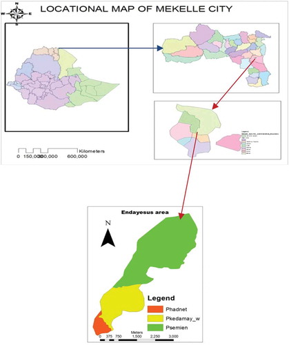
Mekele is found in the Northern part of Ethiopia, 783 km far from Addis Ababa. It is the capital city of National, regional state of Tigray, situated within the boundary of Enderta wereda in the southeastern zone of Tigray region. Its geographical location is 13° 32ʹ North latitude and 39° 28ʹ East longitudes, specifically within the limit of 13° 18ʹ 30ʹ’—13° 39ʹ 52ʹ’ North latitude and 39° 22ʹ 30ʹ’ −39° 39ʹ’ 33ʹ’ East longitude (Municipality, Citation2010) (Figure ).
Figure 1. Study area.
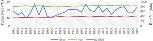
The city has a total population of 273, 459, with 132, 868 Male and 140, 593 Female populations (CSA, Citation2007). It occupies a total area of 74 km 2. Mekele is divided into seven administrative sub cities, namely Kedamay weyane, Semien, Hadinet, Adihaki, Aider, Quiha and Hawelti. The agroclimatic condition of the city is mild (Weyna Dega). Based on the analysis of climate data from 1981–2016 the average rainfall of Mekele is 614.5 ± 150.7 mm with 24.53% coefficient of variance. It was increasing by 36.6 mm every 10 years. Arithmetic mean of the minimum temperature of the study area is 11.31 ± 0.57°C with a 5.02% coefficient of variance. It shows an increase of 0.02°C every 10 years. In addition, arithmetic mean of maximum temperature of the study area is 25.1 ± 0.66°C with 2.63% coefficient of variance. It increased by 0.51°C every 10 years. Therefore, the maximum and minimum temperature and rainfall of the study area showed an increasing trend (Figure ).
Figure 2. Temperature and rainfall trend of the study area.
The vegetation cover of Mekele has been observed varying from time to time. There are some evidences justifying this, in which there are indigenous highland type of forest such as Juniperus procera, Podocarpus (Afrocarpus falcatus), Cordia Africana, Acacia etbaica, etc. in Enda medhanie alem churchyards and Enda rasi recreational sites (Municipality, Citation2010). Endayesus area is also known for its hilly and partly vegetated features. It is found within the city surrounded by Quiha (Eastern part), Semien (North Western part), Kedamay weyane(Western part), and Adihaki(Southern part) sub cities.
2.2. Data collection
Aerial photographs of Mekele for 1665, 1994 and 2009 were purchased from Ethiopian mapping agency and Mekele planning office. These data were used for generating a land cover map of the study area.
Apart from that, 196 households were selected using proportionate random sampling from the three sub-cities to assess the contribution of urban forestry practice in improving forest cover of Endayesus urban forest area. Questionnaire and semi structured interview checklist were used to collect data from sampled households. Besides, 20 key informants were selected from different institutions.
2.3. Data analysis
Data collected from households, key informants and aerial photographs were compiled into segregated databases, cleaned, and checked for accuracy. Statistical tools from SPSS, Microsoft Excel and GIS were used to analyze these data. Spatial analysis was done by which the aerial photos were made to generate seven land cover types in terms of hectare through on-screen digitizing in GIS software. The aerial photos were georeferenced using ground control points. The Universal Transverse Mercator (UTM) projection, Clarke 1880 spheroid, and Adindan zone 37 North datum were used for Geo-referencing the photos. In order to distinguish forest cover of the catchment, land cover of the study area was categorized into seven types; these are, bare land, built up, bushland, farmland, dense forest, sparse forest and scattered tree population. This classification was done using the supervised method of classification. Finally, land cover map of 1965, 1994 and 2009 were generated through GIS analysis.
3. Results
3.1. Forest cover change in Endayesus area
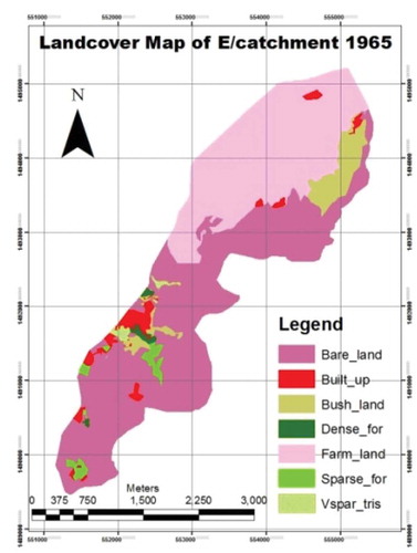
From the land cover of the catchment in 1965 bare land and farmland accounted 51.6% (443 ha) and 36.51% (313.4 ha) of the total area of the designated area, respectively. The rest land use types; built up, bushland, dense forest, sparse forest and scattered trees account 11.89% collectively. All vegetation types accounted 8.69% (74.6 ha) of the total area. Dense and sparse forest cover had coverage of 2.13% (18.3 ha) (Table and Figure ).
Table 1. Land cover of Endayesus catchment over the years by Hectare
Figure 3. L/cover map of E/catchment for 1965.
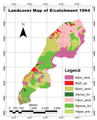
In 1994 sparse forest, farmland and bare land accounted 23.16% (198.8 ha), 22.28% (191.3 ha) and 20.85% (179 ha) respectively, by which the rest, dense forest, scattered trees, bushland and built up accounted 66.29% collectively. All vegetation types (dense forest, sparse forest, bushland and scattered trees cover) had area coverage of 53.5% (459.3 ha). In addition, 24.22% (207.9 ha) area coverage was recorded from dense and sparse forest cover types (Table and Figure ).
Figure 4. L/cover map of E/catchment—1994.
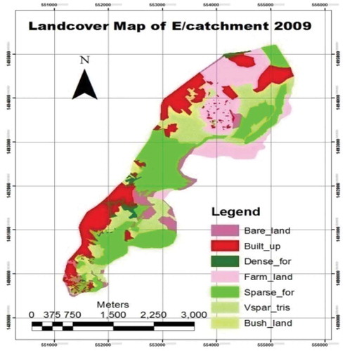
In 2009, built up, farmland, sparse forest, and scattered trees accounted 19.88% (170.7 ha), 20.66% (177.4 ha), 29.86% (256.3 ha) and 18.65% (160.1 ha) of the total area, respectively. The other three land cover types cover an area of 10.95% collectively. All vegetation types covered 53.08% (455.7 ha) of the total land cover area. Dense and sparse forest cover was found to be 31.71% (272.2 ha) of the total (Table and Figure ).
Figure 5. L/cover map of E/catchment for 2009.
As is indicated in the table below, Endayesus area experienced a significant variation of spatial land cover over years.
The above table depicts that the highest land cover change in the time period of 1965–1994 was recorded by scattered trees population (+2059.7%); followed by sparse forest (+1453.13%) and bushland (+115.12%). From 1994–2009 the highest change was observed in built up (490.66%), bushland (−78.07) and dense forest (+74.73%) respectively. The change in land cover type from 1965–2009 proved that scattered trees, sparse forest and built up increased substantially by 2289.55%, 1902.34%, and 520.73%, respectively (Table ).
Table 2. Land cover change in Endayesus catchment over years
All vegetation cover types changed by +515.68%, −0.78% and 510.8% from 1965–1994, 1994–2009 and 1965–2009, respectively. Only dense and sparse forests cover changed by +1036.00%, 30.93% and 1387.43% from 1965–1994, 1994–2009 and 1965–2009, respectively (Table ).
3.2. Role of urban forestry practices in enhancing forest cover of Endayesus area
It is confirmed that exclosure (inhibiting from disturbance) contributed better (32.4% very high and 34.6% higher) than the other activities in increasing forest cover of Endayesus area. It was also reported that plantation has a good contribution (22.3% very high and 19.1% high). The result showed public education contributed very high (14.4%) and high (33%). It was found tree maintenance and care contribute very high (20.7%) and high (14.4%). Enforcing local bylaws was found the least ranked, by which only (11.2% said it contributed very high) and 11.7% said it contributed high (Table ).
Table 3. Role of urban forestry activities in enhancing forest cover of Endayesus
Furthermore, weighted average of the five urban forestry activities was 63.39%, 56.65%. 55.67%, 51.24% and 40.69% for the role of exclosure, plantation, public education, tree maintenance and enforcing local bylaws, respectively. (Table ).
Apart from these, findings from the interview and open-ended questions show that plantation is no more contributing to forest cover increase of Endayesus catchment. Some noted that the result of most forest cover of Endayesus catchment was obtained due to the plantations of eucalyptus trees done during the 1960s and due to protecting the area from animal and human disturbances. Moreover, some experts claimed that plantations are not done based on justified planning in a way to make the forests sustainable and highly benefiting to the community. For instance, an expert from Mekele University, said, “plantations in Endayesus catchment should be by asking questions; what types of tree seedling and where have to be planted for what purpose? However, what we are observing here is simply planting. The local government did not consider the points at which area for what purpose should be planted what, for the sake of optimizing the public benefit”. Data from researcher’s observation also showed that urban agriculture office of the city does not have a plan about what and where to plant and why.
4. Discussion
4.1. Forest cover change in the endayesus catchment
Land cover analysis of Endayesus catchment was done for 1965, 1994 and 2009, with 29 and 15 years difference in between, respectively. The GIS analysis result provides that, during the 1965, the highest land cover with in the catchment was bare land (51.6% of the total land cover) followed by farmland (31.51%). In 1994 the highest land cover was sparse forest (23.16%) followed by farmland (22.28%). Similar with the results of 1994 the highest land cover in 2009 was sparse forest covering 29.86% followed by farmland covering 20.66%. This proves that the catchment’s land cover during 1965 was highly dominated by bare land and farmland type of land uses (both covering 83.11% of the total), testifying that the city’s built up area and forest coverage was very low. In 1994 sparse forest, farmland and bare land showed similar area coverage (23.16%, 22.28%, and 20.85%, respectively). Similarly, sparse forest, farmland, built up and scattered trees land use types were found relatively dominant (25.63%, 20.66%, 19.88%, and 18.65%, respectively) in 2009, the rest with low proportion in the catchment. This shows that the spatial dimension of cities vary through time (JIM, Citation2012).
Similar with other findings (Bewket, Citation2006; Southworth, Citation2001), the three vegetation types, dense forest, sparse forest and scattered trees population has come increasing from time to time, except bushland showed a decreasing trend (Bewket, Citation2006). In the time period from 1965–1994 dense forest, sparse forest and scattered trees increased by 65.45%, 1453.13% and 2059%, respectively. Similarly, from 1994–2009 the area coverage increase was 74.73%, 27.92% and 10.64%, respectively, for the three vegetation classifications. In general, these three vegetation classifications increased by 189.1%, 1902.34% and 2289.55% in the time period of 1965–1994, 1994–2009 and 1965–2009, respectively. This means 0.24 ha per year, 5.5 ha per year and 3.5 ha per year average increase of dense forest, sparse forest and scattered trees cover is recorded, respectively. On the other hand, the change in all vegetation cover types showed an increasing trend from 1965–1994 (515.68%), a decreasing trend from 1994–2009 (−0.78%) and an increasing trend from 1965–2009 (510.8%). If we see the change of dense and sparse forest cover types, an increase of 1036%, 30.93% and 1387.43% is recorded from 1965–1994, 1994–2009 and 1965–2009, respectively. Such improvement in urban forest cover enables the community to get the commercial (Chiras, Citation2013) and other ecosystem service benefits (Mekonnen et al., Citation2017; Nowak et al., Citation2010). The research results of this study are in line with other studies which prove that vegetation cover improved (Bewket, Citation2006; Southworth, Citation2001), built up area increased, bushland and bare land decreased (Bewket, Citation2006; Yeshaneh, Wagner, Exner-Kittridge, Legesse, & Blöschl, Citation2013) temporally. On the other hand, many agreed that forest cover declined (Bosco et al., Citation2011; Yeshaneh et al., Citation2013; Zeleke & Hurni, Citation2006)
Similar with theses vegetation covers the built environment also increased significantly by 5.09%, 490.66% and 520.73% from the year intervals of 1965–1994, 1994–2009 and 1965–2009, respectively. This shows that urban growth is resulting in high burden on natural areas and ecosystems (Bekessy & Gordon, Citation2007). The rest land use types showed a negative increase in all the time interval periods, with bare land being the highly decreased one (87.65% decrease from 1965–2009).
A research in selected areas of Tigray (North Ethiopia) found similar findings with the results of this research. It proves that woody vegetation and built up area increased strongly, which mostly occurred at the expense of bushland (Meire et al., Citation2013). On the contrary, a research in the land cover analysis of Mekele showed that sparse forest showed no change. This could be due to methodology and material differences or due to this research’s focus on a specific area of Mekele. The study also found that urban features in Mekele increased by 200% in the years between 1985 and 2010 (Tahir & Hussain, Citation2013).
4.2. Role of urban forestry practices in enhancing forest cover of Endayesus catchment
Forestry practices have been carried out for years in Ethiopia, including in urban areas. These activities resulted in promising results in the vegetation cover changes of the country. Urban forestry in Endayesus catchment of Mekele is the responsibility of urban agriculture office with the help of Mekele University. Results from the survey indicated that urban forestry practices in Endayesus catchment are enabling forests to increase. According to most respondents exclosure was said highly contributing in enhancing forest cover of the catchment (63.39%). Creating awareness on the importance of urban forestry is an important component of its development strategy (Fuwape & Onyekwelu, Citation2011). In doing so the city seems moving some miles. Plantation (56.65%) and public education (55.67%) about urban forestry was the next highest ranked activity in its contribution to forest increase of Endayesus catchment. This shows that reforestation is contributing in enhancing forest cover (Southworth, Citation2001) of urban areas.
But, some said that in the recent times plantation is becoming investing for nothing, because planted trees did not always survive even until the next year. They believe the forest cover is in a good situation because trees planted before years are being protected well in which disturbance level is low. One expert stated “had it been successful in forest cover increase like is planted every year, it could be a great move; but recently planted trees are good for nothing. The trees we are observing are those which were planted before many years and also regenerated by themselves”. But this could not be to mean that plantation contributed nothing, rather, is not equivalent with the efforts made and is not as expected, especially in the recent times.
Oher findings indicated that developing tropical countries have recently been through forest cover increase, due to performing different forestry activities; showing similar trends with this research. These authors also state that planted trees have increased by 4.9Mha/year during the period 2000–2010 globally (Meyfroidt & Lambin, Citation2011).
5. Conclusion
Vegetation cover in 1965 was very limited, by which bare land use type was highly dominant. Where as in both 1994 and 2009 dense forests, sparse forest and scattered tree population increased at an encouraging rate. This success was due to continuous plantation and protection activities over the years. It is a prospect that forest cover is increasing and bare land is decreasing and a challenge that built up area is increasing within the restricted urban forest area. Nevertheless, a significant amount of area coverage is found bare land, bushland and with scattered trees population, seeking to be changed to the forest area. Exclosure is having a good contribution in enhancing forest cover of Endayesus. Plantation and public education are also putting their own signature significantly.
The catchment should have a land cover/use plan, prepared in a way to maximize the benefits of urban forestry within the catchment based on established multiple criteria. In addition, modeling the possible damage to Mekele city under vegetated and non-vegetated scenarios of Endayesus catchment in different climatic conditions is important for residents and the local government to be prepared for the possible damages, if any.
Additional information
Funding
Notes on contributors
Berihu Tesfamariam Zeratsion
Berihu Tesfamariam Zeratsion is researcher in Ethiopian environment and forest research institute (EEFRI), Mekele environment and forest research center (MEFRC). His research thematic areas are climate science, climate change and forests. On top of his research activities he is currently serving as center director of MEFRC.
References
- Bekessy, S., & Gordon, A. (2007). Nurturing nature in the city. Steering Stustainability in an urbanising world: Policy, practice and performance, 227–238.
- Bewket, W. (2006). Land cover dynamics since the 1950s in Chemoga Watershed, Blue Nile Basin, Ethiopia. Mountain Research and Development, 22(3), 263–12. doi:10.1659/0276-4741(2002)022[0263:lcdsti]2.0.co;2
- Bosco, N. J., Geoffrey, M. M., & Kariuki, N. N. (2011). Assessment of landscape change and occurrence at watershed level in city of Nairobi. African Journal of Environmental Sciences, 5(October), 873–883. doi:10.5897/AJEST11.154
- Chiras, D. D. (2013). Environmental science. USA: Jones and Bartlet Learning Compant.
- CSA. (2007). Population and housing census report-country - 2007. Addis Ababa: Author.
- FAO. (2012). Urban and peri-urban forestry in Africa: the outlook for woodfuel, Urban and peri-urban forestry working paper (pp. 95). Rome.
- Fuwape, J. A., & Onyekwelu, J. C. (2011). Urban forest development in West Africa: Benefits and challenges. Journal of Biodiversity and Ecological Sciences, 1(1), 77–94.
- Jensen, R., Gatrell, J., Boulton, J., & Harper, B. (2016). Using remote sensing and geographic information systems to study urban quality of life and urban forest amenities. Ecology and Society, 9(5). doi:10.5751/es-01201-090505
- JIM, C. Y. A. L. H. (2012). Patterns and dynamics of urban forests in relation to land use and development history in Guangzhou City, China. The Geographical Journal, 167(4), 358–375. doi:10.1111/1475-4959.00031
- Keesstra, S., Mol, G., de Leeuw, J., Okx, J., Molenaar, C., de Cleen, M., & Visser, S. (2018). Soil-related sustainable development goals: Four concepts to make land degradation neutrality and restoration work. Land, 7(4), 133. doi:10.3390/land7040133
- Keesstra, S. D., Bouma, J., Wallinga, J., Tittonell, P., Smith, P., Cerdà, A., … Fresco, L. O. (2016). The significance of soils and soil science towards realization of the United Nations sustainable development goals. Soil, 2(2), 111–128. doi:10.5194/soil-2-111-2016
- Locatelli, B. (2015). Local, global: Integrating mitigation and adaptation. Local, Global: Integrating Mitigation and Adaptation. doi:10.17528/cifor/003231
- Meire, E., Frankl, A., De Wulf, A., Haile, M., Deckers, J., & Nyssen, J. (2013). Land use and cover dynamics in Africa since the nineteenth century: Warped terrestrial photographs of North Ethiopia. Regional Environmental Change, 13(3), 717–737. doi:10.1007/s10113-012-0347-9
- Mekonnen, M., Keesstra, S. D., Baartman, J. E. M., Stroosnijder, L., & Maroulis, J. (2017). Reducing sediment connectivity through man-made and natural sediment sinks in the Minizr catchment, Northwest Ethiopia. Land Degradation and Development, 28(2), 708–717. doi:10.1002/ldr.2629
- Meyfroidt, P., & Lambin, E. F. (2011). Global forest transition: Prospects for an end to deforestation. SSRN. doi:10.1146/annurev-environ-090710-143732
- Moges, Y., Eshetu, Z., & Nune, S. (2010, October). Ethiopian forest resources : Current status and future management options in view of access to carbon finances (pp. 54). Addis Ababa: Ethiopian Climate Research and Networking and the United Nations Development Programme (UNDP).
- Muluneh, A., Stroosnijder, L., Keesstra, S., & Biazin, B. (2017). Adapting to climate change for food security in the Rift Valley dry lands of Ethiopia: Supplemental irrigation, plant density and sowing date. Journal of Agricultural Science, 155(5), 703–724. doi:10.1017/S0021859616000897
- Muluneh, A., van Loon, E., Bewket, W., Keesstra, S., Stroosnijder, L., & Burka, A. (2017). Effects of long-term deforestation and remnant forests on rainfall and temperature in the central Rift Valley of Ethiopia. Forest Ecosystems, 4(1). doi:10.1186/s40663-017-0109-8
- Municipality, M. C. (2010). Environmental and physical features of Mekele city. Mekele: Zemenawi Printing press.
- Nowak, D. J., Stein, S. M., Randler, P. B., Greenfield, E. J., Comas, S. J., Carr, M. A., & Alig, R. J. (2010, June). Sustaining America’s urban trees and forests. USDA Technical Report, Northern Reseach Station NRS-62. 27. https://doi.org/Gen. Tech. Rep. NRS-62
- Solomon, N., Hishe, H., Annang, T., Pabi, O., Asante, I., & Birhane, E. (2018). Forest cover change, key drivers and community perception in Wujig Mahgo Waren forest of Northern Ethiopia. Land, 7(1), 32. doi:10.3390/land7010032
- Southworth, J. (2001). The influence of accessibility, local institutions, and socioeconomic factors on forest cover change in the mountains of Western Honduras. Mountain Research and Development, 21(3), 276–283. doi:10.1659/0276-4741(2001)021[0276:TIOALI]2.0.CO;2
- Tahir, M., & Hussain, T. (2013). Evaluation of land use/land cover changes in Mekelle City, Ethiopia using remote sensing and GIS. Computational Ecology and Software, 2013(1), 9–16.
- Yan, Y., Trouvé, E., Bisserier, A., Mauris, G., Galichet, S., Pinel, V., & Pathier, E. (2010). Assimilation of D-InSAR and sub-pixel image correlation displacement measurements for coseismic fault parameter estimation. International Geoscience and Remote Sensing Symposium (IGARSS), 3664–3667. doi:10.1109/IGARSS.2010.5654408
- Yeshaneh, E., Wagner, W., Exner-Kittridge, M., Legesse, D., & Blöschl, G. (2013). Identifying land use/cover dynamics in the koga catchment, Ethiopia, from multi-scale data, and implications for environmental change. ISPRS International Journal of Geo-Information, 2(2), 302–323. doi:10.3390/ijgi2020302
- Zeleke, G., & Hurni, H. (2006). Implications of land use and land cover dynamics for mountain resource degradation in the Northwestern Ethiopian highlands. Mountain Research and Development, 21(2), 184–191. doi:10.1659/0276-4741(2001)021[0184:iolual]2.0.co;2