
 ?Mathematical formulae have been encoded as MathML and are displayed in this HTML version using MathJax in order to improve their display. Uncheck the box to turn MathJax off. This feature requires Javascript. Click on a formula to zoom.
Abstract
Land suitability analysis is a prerequisite for sustainable agricultural production. This study was aimed at evaluating the current physical land suitability for major cereal crops: teff, wheat, barley and maize in the Dabo-Hana district, Bunno Bedelle Zone, Southwest Ethiopia. A GIS and RS technique with a multi-criteria evaluation approach was applied for evaluating the physical land suitability for the major crops. Various physical land attributes, namely temperature, rainfall, altitude, slope, soil (soil depth, PH, texture, and drainage), land use land cover, accessibility to market and proximity to road have been used as input parameters. Physical land suitability maps were generated for the major cereal crops. The optimum vector overlay analysis results revealed that from the total area, 15,298 ha (20.34%) and 12,494 ha (16.8%) is highly suitable and moderately suitable for all teff, wheat, barley, and maize crop production, respectively. The remaining area has a mixed suitability status (suitable for some crops and unsuitable for others) for all the analyzed crops. This study demonstrated that based on physical land suitability analysis the study area has huge potential for cereal crop production. Topographic factor (altitude) and climatic factors (temperature and rainfall) are the dominant factors that influence the suitability of agricultural land for the major crops in the study area. This study report urges the concerned stakeholders to properly use and adopt precisely the optimum physical land suitability planning to expend the present land resources for more cereal crop productivity in a sustainable manner for better socio-economic development of the region.
PUBLIC INTEREST STATEMENT
Agricultural land suitability analysis is important for effective and efficient utilization of land resources. This paper presents the physical land evaluation for selected cereal crops growing in Dabo Hana district, southwest Ethiopia. GIS and RS application techniques were applied to use the Multi-criteria decision support system. Different physical agricultural land attributes, namely temperature, rainfall, altitude, slope, soil (soil depth, PH, texture, and drainage), land use land cover, accessibility to market, and proximity to road have been used as input parameters. The result shows that about 37% of the study area is suitable for all the selected major cereal crops. Whereas the remaining area has mixed suitability like some areas are only suitable for either one or two or three types of crops. The finding of this study is useful for decision-makers to ensure optimized agricultural land-use planning to maximize cereal crop production to enhance food security in the community.
Competing interests
The authors declare that they have no competing interests.
1. Background
On a global scale, agriculture has proven the potential to increase food supplies faster than the growth of the population, a pattern to be expected in the foreseeable future (Dent, Citation1993). There is growing concern about food security in Africa and especially in sub-Saharan Africa. While the aggregate global food supply and/or demand picture is relatively good, it is predicted that there will be a worsening condition in food security in sub-Saharan Africa (FAO, Citation1993). As the world population grows; an increase in the food supply is urgently needed to meet the concurrent increase in demands. According to (Schinca, Citation2009) report in three decades of agriculture production in the sub-Saharan region, besides losing export market it failed to increase the production of food calories per capital above 2100/day.
A land resource is gradually becoming a scarce resource, and population growth may exert pressure on the available limited natural resources. Even though the issue of agricultural productivity and food security is widely studied in different parts of the world, the impact of unwise use of land resource and absence of utilization of the land according to its potential suitability is still a serious problem particularly in developing countries (Ghasemi Pirbalouti et al., Citation2011). In order to increase food production and provide food security, therefore crops need to be grown in areas where they are best suited. In this regard, the first and foremost requirement is carrying out land suitability analysis (Kihoro et al., Citation2013). According to the Ministry of Finance and Economy Development (MoFED, Citation2014) report, agricultural land suitability analysis is very important since agriculture accounts on average for about 42.9% of Growth Domestic Product (GDP) in 2014 compared to 46.5% in 2009/10. In addition, the agriculture sector covers 83.9% of exports and 80% of the labor force in Ethiopia. The same source indicated that Ethiopia has high agricultural potential because of its vast areas of fertile land, diverse agro-ecological environment, and availability of a large labor pool which can enhance agricultural productivity.
Recently, the most important and urgent problem in Ethiopia is to improve agricultural land management with an effective and efficient land-use system for better socio-economic development (Abera, Citation2008). The problem of selecting the correct land for the cultivation of a certain agricultural product is a long-standing and mainly empirical issue. According to (Girma & kanate, Citation2017). Ethiopia the southwestern high lands of Ethiopia is facing various problems resulted from unwise use of land resources. However, the magnitude of the problem has not been clearly identified and studied as expected.
Physical land suitability evaluation that considered physical factors such as climate, soil, land use, and topography has long been studied by several authors (Duguma, Citation2010; Hailegebriel, Citation2007; Mulugeta, Citation2010; Slehak, Citation2007). The authors pointed out that these are not the only factors that determine the suitability of a given land for a given specific type of land use. Other factors such as infrastructure and socio-economic factors need to be taken into account.
In Dabo Hana district, southwest Ethiopia, population growth and limited option of livelihood opportunity coupled with climate variability have led the community to put the scarce available land to uses to which the land is not best fit. This has led to a decrease in agricultural productivity per hectare of land. Therefore, the Agriculture and Natural Resources Office of the district has shown a great interest to have an agricultural land suitability evaluation to achieve optimum land utilization for sustainable agricultural productivity in the district. Hence, this study was initiated to conduct an integrates multi-criteria land suitability evaluation with GIS to identify the suitable areas for selected major cereal crops, namely teff (Eragrostis tef Zucc), wheat (aestivum L.), barley (Hordeum Vulgare L.) and maize (Zea mays L.) using such land qualities as soil, climate, land-use land cover, market and road access, and topography with the overall objective of improving cropland productivity and the livelihood of the smallholder farmers in the district. Therefore, we carried out a physical land suitability evaluation for major cereal crops using GIS and RS application techniques for Dabo Hana district, Southwest Ethiopia. The results of this study would help to improve the existing agricultural land-use system for optimum land-use planning and management through sustainable agriculture and biodiversity conservation.
2. Materials and methods
2.1. Description of the study area
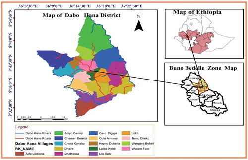
This study was conducted in Dabo Hana District. It is located between 36°5ʹ 27” and 36°26ʹ 19”E longitude and 8°30ʹ 21” to 8°55ʹ 20”N latitude. And the district is about 519 km far from the capital city, Addis Ababa to the southwest direction. The town of the district which is called Kone is about 36 km far from the zonal capital town, Bedelle. The district has a total area of 74,725.87 hectares (Figure ). The altitude of the district ranges between1190 and 2323 m.a.s.l (Dabo Hana District, Agriculture, Citation2016). According to (CSA, Citation2007) (Central Statistic Agency), population projection in 2017, the total population of Dabo Hana district was estimated to be 53,938. Agro-ecologically, 74,426 ha (23.33%) the total land size of the district is Kola (hot) (500–1500 m.a.s.l), 76.63% Woinadega (temperate) (1500–2300 m.a.s.l.) and 0.043% Dega (cold) (>2300 m.a.s.l). The district receives an average annual rainfall of 900 to 2,200 mm. The rainy season extends from April to October and the maximum rain is received in the months of May, June, July, August, and September with the mean monthly rainfall exceeding 2,200 mm. The annual average, mean minimum and mean maximum temperatures are 19.8°c, 11°c, and 28°C, respectively (NMA_National Meteorological Agency, Citation2016). There are different types of soils in the study area, but Nitisols is the most dominant type of soil.
Figure 1. Location map of the study area (own source).
2.2. Crop production of Dabo Hana district
The area is covered with a variety of crops and natural vegetation. The major crops produced in the district are e.g., teff, wheat, barley, maize, sorghum, and millet, pulses (chickpea, lentil, faba bean, vetch, and pea), oilseeds (linseed) and vegetables (garlic, onion, green pepper, potato). Cereal crops are produced mainly for consumption and market. Pulses (mainly chickpea and lentil) are produced largely for markets and they are considered valuable cash crops. Teff, maize, sorghum, wheat, barley, chickpea, and lentil are the most important crops (Table ) in terms of area coverage, production per hectare and market demand (Dabo Hana District, Agriculture, and Natural Resources report, Citation2016).
Table 1. Cereal crop production of 4 years of yield/quintal
2.3. Research design
This study was based on a partially mixed sequential dominant status-quantitative/technical research design. This is because as stated in (Powell et al., Citation2008) quantitative/technical and qualitative phases occur one after the other, with the quantitative/technical phase being given higher priority and mixing occurring at the data interpretation stage. The priority is given to the quantitative data, and the two methods are embedded during the interpretation stage of the study.
2.3.1. Data types and sources
Socio-economic primary data were obtained through field surveys and key informant interviews; ground control points were collected by using GPS (geographical positioning system). Secondary data types like a satellite image, soil data (soil pH) is obtained from Bedelle soil laboratory center, whereas soil depth, drainage, and soil texture data were obtained from WLRC/water and land resource center _Addis Ababa University), DEM (digital elevation model), climate data were obtained from USGS (United States Geological Survey), HWSD/ISRIC/, USGS, Worldclim, as well as from Dabo Hana Agriculture and Rural Development office and Rural Land Administration and Land Use Planning offices (Table ).
Table 2. Data types and sources
3. Parameters used for evaluation of crop suitability
3.1. Crop requirements and criteria rating
Crop requirements are established following the approach of (FAO, Citation1984; Landon, Citation1991) and the guidelines of (Sys et al., Citation1991). Adaptation has been made with respect to the grouping of requirements according to FAO (Citation1984) guidelines. The selected crops that were evaluated for this specific study include teff, wheat, barley, and maize. In this particular land suitability analysis for selected major cereal crops, the criteria are mainly related to topography (altitude and slope), climate (rainfall and temperature), soil (soil depth, soil PH, soil texture and soil drainage), land use/land cover, proximity to market and road. These are the most important requirements needed for all crops. A compilation of the crop requirements that were considered in the evaluation was made, and factor rating for crops is decided. Factor ratings are sets of values that indicate how well each factor is satisfied by particular conditions of the corresponding land quality. Factor ratings are usually made in terms of five classes: highly suitable, moderately suitable, marginally suitable, currently not suitable, and permanently not suitable (FAO, Citation1985).
3.1.1. Criteria standardization and assigning criterion weights
The evaluation choices could be expressed according to different scales. The large value of the multi-criteria method needs that all criteria are expressed on the same scale. Standardization of criteria allows the re-scaling of evaluation dimensions between 0 and 1 where 0 indicates not suitable and value 1 indicates suitable. Following the processing and preparation of data, the factors were organized in the class of fit to their weight of importance. In the AHP (Analytical hierarchal process) approach, the criteria are standardized, by using pairwise comparison methods. The standardization of factors or criteria brought about in ratings is based on literature and agricultural experts (such as agricultural experts and development agents)(Table ).
Table 3. Cereal crop environmental requirements at different suitability classes
The purpose of weighting in land suitability analysis for agricultural crops is to express the importance or preference of each factor relative to other factor effects on crop yield and growth rate. In the procedure for MCE (Multi-criteria evaluation), it is necessary that the sum of the weights equal to one. In developing a pairwise comparison matrix, all the factors are compared two at a case in terms of their standing related to the declared objective. In developing weights, an individual or group compares every possible pairing and enters the evaluation into a pairwise comparison matrix (Gbanie et al., Citation2013). Since the matrix is symmetric, only the lower triangle necessarily to be filled in. The remaining cells are then simply the reciprocals of the lower triangle (Table ).
Table 4. Scale of rating influence of factors (Saaty, Citation2002)
3.1.2. Weighted overlay analysis
The weighted overlay analysis was used to aggregate all the factors/criteria under investigation. It is applied to combines a weight to each factor followed by aggregation of the factor weight results to produce the final land suitability map. Because of the different scales upon which criteria are measured, it is necessary that factors are standardized before combination using Equationeq.(1)(1)
(1) and the type is transformed, if necessary, such that all factor maps are positively correlated with suitability (Rabia & Terribile, Citation2013). The weights were developed by providing a series of pairwise comparison matrix of the relative importance of the factors to the suitability of pixels for the activity was analyzed. The pairwise matrix comparisons were then analyzed to produce a set of weights that sum to one (EquationEquation (1)
(1)
(1) ) (Rabia & Terribile, Citation2013).
where S is suitability, Wi is weight of factor, and Xi is criterion score of factor i.
3.2. Methods of data analysis
In this study, a multi-criteria decision-making (MCDM) was selected and used. It is commonly known that the spatial analysis part of ArcGIS is used for optimum land suitability analysis (Jankowski, Citation1995; Malczewski, Citation1996). In contrast to conventional MCDM analysis, spatial multi-criteria analysis requires information on criterion values and the geographical locations of alternatives in addition to the decision-makers’ preferences with respect to a set of evaluation criteria (Ascough et al., Citation2002). This means analysis output depends not only on the geographical distribution of attributes but also on the value judgments involved in the decision-making process. Therefore, we used a non-probability sampling technique to select two agricultural experts, two development agents. Further, four community leaders/elders and six model farmers were interviewed from different villages for triangulation of the results.
4. Results
4.1. Suitability of socio-environmental factors
Figure ) shows that the land-use land cover of the area is dominated by farmland (40.1%), forest (27.97%) and bushland (26.59%). The remaining areas are settlement and swampy which constitutes 4.21% and 1.11%, respectively. Thus, the land-use land cover classification indicates that the study area has a high potential for agricultural practices. Accuracy assessment of the land-use land cover classification has been made, and the overall accuracy is 86.67% and the kappa coefficient is 0.834. The classification accuracy assessment results are acceptable (Congalton, Citation1991; Lillesand & Kiefer, Citation1994).
Climate plays an important role in the suitability of lands for cereal crop production. Cereal crop cultivation requires particular amounts of rainfall and temperature. According to (Hurni, Citation1998) and (Asres, Citation1996), the large part of the study area lies within three agro-ecological zones, namely Dega (cold), Weinadega (temperate) and Kolla (hot). In the same literature, temperature is one of the limiting factors for crop production. The study area has three agro-ecological zones with various degrees of temperature and thus classified into four suitability classes for the selected major cereal crops. Thus, based on temperature as a factor, the study area was reclassified into four classes (Figure )). Temperature ranges between 15°C and 16°C (4.45%), 16°C and 17°C (6.23%), 17°C and 18°C (28.58%), and 18°C and 20°C (60.73%) classified as highly suitable, moderately suitable, marginally suitable and not suitable for teff, wheat, and barley, respectively. For maize, 18–20°C (60.73%), 17–18°C (28.58%), 16–17°C (6.23%), and 15–16°C (4.45%) were classified as highly suitable, moderately suitable, marginally suitable and not suitable for maize production, respectively (FAO, Citation1984; Landon, Citation1991). Since the source of water for rain-fed agriculture is, rainfall, its distribution and dependability play a significant role in optimizing agricultural production. Thus, the average rainfall distribution together with its variation in both frequency and extent entails its agronomic importance. Figure ) reveals that the rainfall ranges between 1766 and 1933 mm (19.61%), 1685 and 1766 mm (43.28%), 1611 and 1685 mm (12.14%), and 1518 and 1611 mm (24.98%) were classified as highly suitable, moderately suitable, marginally suitable and not suitable for teff, wheat, and barley, respectively. For maize rainfall ranging from 1518 to 1611 mm (24.98%), 1611 to 1685 mm (12.14%), 1685 to 1766 mm (43.28%), and 1766 to 1933 mm (19.61%) were classified as highly suitable, moderately suitable, marginally suitable and not suitable, respectively (Driessen et al., Citation2001; Sys et al., Citation1993)
The elevation and slope of the study area were derived from ASTER DEM of 30 m resampled to 10 m spatial resolution. Altitude and slope play an important role in agricultural activities in general, and particularly for crop production. (Ahmed & Jeb, Citation2014) also indicated in their study of Bunkure Kano state of Nigeria, both altitude and climate factors are the major parameters that influence land suitability of crop production. The altitude of the study area ranges between 1,190 m to 2,323 m a.m.s.l and the slope ranges between 0% and 70%. The altitude and slope of the study area are categorized into four suitability classes’ namely highly suitable, moderately suitable, marginally suitable, currently not suitable classes according to land suitability analysis classification of (FAO, Citation1984). In Figure ), it is indicated that the altitude ranges between 2000 and 2323 m (9.55%), 1800 and 2000 m (18.53%),1500 and 1800 m (28.06%), and 1190 and 1500 m (43.86%) and classified as highly suitable, moderately suitable, marginally suitable and not suitable for teff, wheat, and barley, respectively. For maize crop from 1190 to 1500 m (43.86%), 1500 to 1800 m (28.06), 1800 to 2000 m (18.53%), and 2000 to 2323 m (9.55%) classified as highly suitable, moderately suitable, marginally suitable and not suitable, respectively. Presented in Figure ), slope ranges between 0 and 8 (45.5%), 9 and 15 (31.5%), 16 and 24 (17.25%), and >25 (5.7%) are classified as highly suitable, moderately suitable, marginally suitable and not suitable for teff, wheat, barley, and maize, respectively. The slope of a given area plays an important role in agricultural activities in general, and particularly for cereal crop production. Normally cereal crops require a slightly gentle slope of the land for smooth and easy tillage practice (Missaoui, Citation1996; USAID, Citation2014).
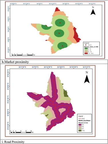
A soil characteristic is one of the most important factors in agricultural land-use assessment. In this study soil depth, texture, drainage, and pH are taken as indicators to assess the general soil suitability for agriculture (Figure )). Deep and well-drained soil shows a root penetration until below 150 cm for most crops, however, root penetration might be stopped at shallower depth because of physical root restricting or chemical properties of soil (Mulugeta, Citation2010; Suresh, Citation2004). Generally, soil type with soil depth with 70–150 cm, well-drained, with a pH between 5.5 and 7.5, and with a texture of loam, clay, silty clay were classified as highly suitable for selected cereal crops (Figure )) (Hazelton, Citation2007). Figure ), proximity to market analysis was carried out by using Euclidean distance proximity analysis which resulted in 0–4 km (22.93%), 4–8 km (38.45%) 8–12 km (33.07%), and 12–15 km (5.55%) were classified as highly suitable, moderately suitable, marginally suitable and not suitable due to the distance from the cropland, respectively (Widiatmaka, Citation2016). Figure ) reveals that using spatial analyst tool Euclidian distance of road proximity analysis, land far from road by 0–2 km (55.6%), 2–4 km (26.07%), 4–7 km (15.99%) and 7–10 km (2.35%) is classified as highly suitable, moderately suitable, marginally suitable and not suitable due to the distance from the cropland, respectively (Widiatmaka, Citation2016).
Figure 2. Socio-environmental data suitability (a) Land-use land cover (b) Temperature (c) Rainfall (d) Altitude (e) Slope (f) Soil property (g) Soil (h) Market proximity (i) Road proximity.
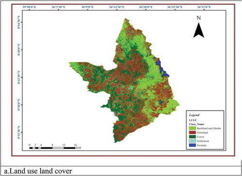
Figure 2. (Continued).
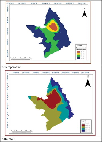
Figure 2. (Continued).
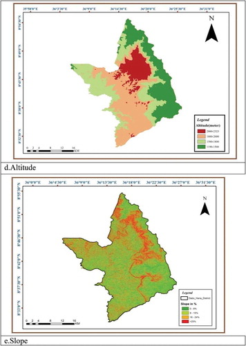
Figure 2. (Continued).
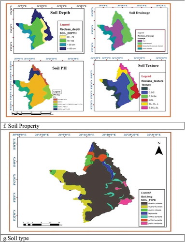
Figure 2. (Continued).
4.2. Land suitability analysis for major cereal crops
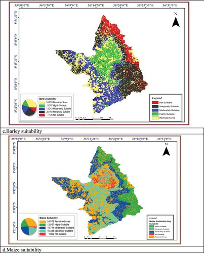
The land suitability analysis for teff indicated that 11,178 hectares (15%); 20,566 hectares (27.5%); 15,302 hectares (20.5%); 2,802 hectares (3.7%) of the land of the total area is highly suitable, moderately suitable, marginally suitable and not suitable, respectively (Figure )). Of the total area, 24,878 ha (33.3%) of the land is considered as a restricted area that constituent forest, swampy and settlement. The result of this finding is more or less similar to a study conducted by Slehak (Citation2007) on teff suitability around the Awash River basin, Ethiopia. On the other hand, 6,458 hectares of land (8.6%) are classified as highly suitable, 14,272 hectares (19.1%) moderately suitable, 20,611 hectares (27.6%) marginally suitable, and 8,507 hectares (11.4%) of land are not suitable for wheat production (Figure )). (Mulugeta, Citation2010) also conducted a land suitability study for wheat in Legambo district and his result was also similar to our findings. As indicated in Figure ).rom the total area of the study 9,307 hectares (12.5%) are classified as highly suitable 13,243 hectares (17.7%) moderately suitable, 20,168 hectares (27%) marginally suitable and 7,130 hectares (9.5%) of land are not suitable for barley production. Similarly, Motuma et al. (Citation2016) made a land suitability study for barley and their finding is almost in line with our suitability proportion. There is a slight percentage variation that might be due to geographical location differences. Further, as illustrated in Figure ), 12,857 hectares (17.2%); 18,744 hectares (25.1%); 16,385 hectares (21.9%); and 1,862 hectares (2.5%) of land are classified as highly suitable, moderately suitable, marginally suitable, and unsuitable for maize production, respectively.
Figure 3. Map of cereal crops land suitability in Dabo Hana district. (a) Teff (b) Wheat (c) Barley (d) Maize.
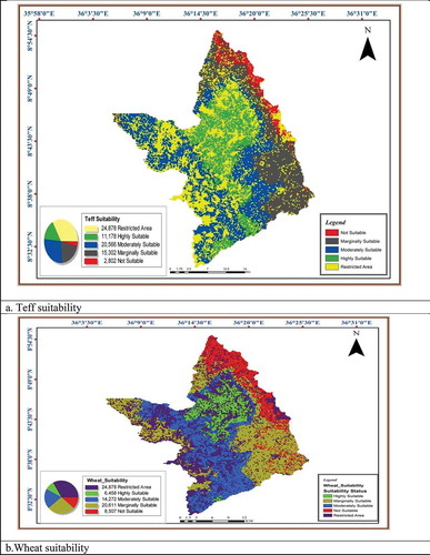
Figure 3. (Continued).
4.2.1. Optimum land suitability allocation of major cereal crops
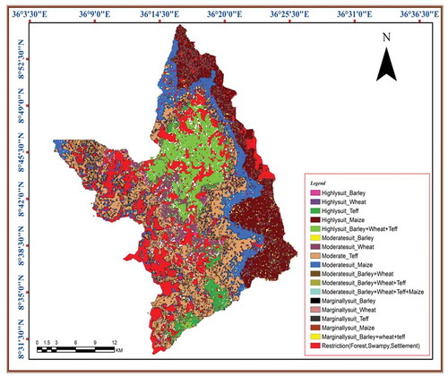
As presented in Figure from the total area, 15,298 ha (20.34%) and 12,494 ha (16.8%) is highly suitable and moderately suitable for teff, wheat, barley, and maize crop production, respectively. The remaining area has a mixed suitability status (suitable for some crops and unsuitable for others) for all the analyzed crops. More than 56% of the area is highly and moderately suitable for teff, wheat, barley, and maize production. Research conducted in the northern part of Gela catchment by (Suresh, Citation2004) reported relatively similar results, 20.5% of the study area is moderately suitable for all stated cereal crops. In the same manner, the research studied by (Duguma, Citation2010) at Mojo watershed resulted in comparatively approximate result as our findings.
Figure 4. Map of optimum land suitability allocation for major cereal crops in Dabo Hana district.
5. Conclusions
The assessment of the physical land suitability of the study area indicates that the study area has huge potential for cereal crop production. Based on this finding the topographic factor (altitude) and climatic factors (temperature and rainfall) are the dominant factors that influence the suitability of agricultural land. While areas with high altitudes, low temperature and high amounts of rainfall are most suitable for teff, barley, and wheat middle and low altitude areas are most suitable for maize. The overall vector overlay analysis (union) allocates the best suitable land and identifies places for which land utilization types compete at the same level of suitability class. The results revealed that 8.4%, 11.3%, 2.4%, and 12.4% of land are found to be highly suitable, moderately suitable, and marginally suitable for teff, wheat, barley, and maize crop production, respectively. Hence, the suitability of land classification analysis assured that more area of land is available which is suitable for cereal crop productivity. However, decision-making on land suitability for different crops not only requires limited physical parameters but also multiple socio-economic and environmental variables consideration is very important. Generally, this study report can be used as an initial tool for developing and implementing an optimum physical land-use planning for proper allocation of the land for the major cereal crops in the study area.
Abbreviation
| AHP | = | Analytical hierarchal process |
| m.a.s.l | = | Above mean sea level |
| ASTER DEM | = | Advanced Spaceborne Thermal Emission and Reflection Radiometer Digital Elevation Model |
| GIS | = | Geographical Information System |
| FAO | = | Food and Agricultural Organization |
| MCE | = | Multi-criteria evaluation |
Author contributions
DB was responsible for collecting and analyzing the data as well as writing the manuscript. SG contributed to analyzing the data, writing, editing, and shaping the manuscript. AM contributed to guiding the research. AR contributed to the writing and overall edition of the manuscript.ST contributed to editing the manuscript.
Consent for publication
We have agreed to submit for Cogent Food & Agriculture Journal and approved the manuscript for submission.
Acknowledgements
The authors would like to thank Jimma University for providing GIS lab tools. We would like also to extend our gratitude to Dabo Hana governmental offices for the smooth management process and for providing secondary documents.
Additional information
Funding
Notes on contributors
Gemechu Debesa
Gemechu Dabesa is a lecturer at Jimma University. He has M.Sc degree in GIS and RS from Jimma University.
Sintayehu Legesse Gebre
Sintayehu Legesse Gebre is an assistant professor in Hydrology and water resources engineering at Jimma University. He has a multidisciplinary academic and professional background. Currently, he is a Ph.D. fellow at KU Leuven University.
Ashenif Melese
Ashenif Meles and Sintayehu Teka are working at the department geography, Jimma University.
Alemayehu Regassa
Alemayehu Regassa (Ph.D.) is an associate professor at Jimma University. He is a senior researcher in the field of soil science.
References
- Abera, H. B. (2008). Adoption of improved tef and wheat production technologies in crop-livestock mixed systems in northern and western Shewa Zones of Ethiopia (Vol. 2010). University of Pretoria.
- Ahmed, M., & Jeb, D. N. (2014). Land suitability for sorghum using Multicriteria Evaluation (MCE) and Analytical Hierarchy Process (AHP) in Bunkure Kano State, Nigeria. IOSR Journal of Agriculture and Veterinary Science, 7(9), 25–20. https://doi.org/10.9790/2380-07942537
- Ascough, J. C., II, Rector, H. D., & Hoag, D. L. (2002). Multicriteria spatial decision support systems: Overview, applications, and future research directions. In Conference on integrated assessment and decision support (Vol. 3).
- Asres, T. (1996). Agroecological zones of Southwest Ethiopia (Vol. 13). Universitaet Trier.
- Congalton, R. G. (1991). A review of assessing the accuracy of classifications of remotely sensed data. Remote Sensing of Environment, 37(1), 35–46. https://doi.org/10.1016/0034-4257(91)90048-B
- CSA. (2007). Population census of the Federal Democratic Republic of Ethiopia. Central Statistical Authority.
- Dabo Hana District Agricultural and Natural Resource report. (2018). Cereal crops yield report.
- Dabo Hana District, Agriculture, and N. R. report. (2016). Agriculture and natural resources office report.
- Dent, D. (1993). The evaluation of land resources. Journal of Rural Studies, 9(Second), 106. https://doi.org/10.1016/0743-0167(93)90018-f
- Driessen, P., Deckers, J., Spaargaren, O., & Nachtergaele, F. (2001). Lectures and notes on the major soils of the world (World Soil Resources Reports No. 94).
- Duguma, D. W. (2010). GIS and remote sensing-based land suitability analysis for agricultural crops in Mojo watershed, upper Awash sub-basin, Ethiopia.
- FAO. (1984). Crop environmental requirements; report prepared for the Government of Ethiopia by FAO acting as executing agency for the UNDP (Land evaluation: Technical report 5, Part III).
- FAO. (1985). Guidelines: Land evaluation for irrigated agriculture. FAO Soils Bulletin (Vol. 55).
- FAO. (1993). Guidelines for land-use planning.
- Gbanie, S. P., Tengbe, P. B., Momoh, J. S., Medo, J., & Kabba, V. T. S. (2013). Modelling landfill location using Geographic Information Systems (GIS) and Multi-Criteria Decision Analysis (MCDA): Case study Bo, Southern Sierra Leone. Applied Geography, 36, 3–12. https://doi.org/10.1016/j.apgeog.2012.06.013
- Ghasemi Pirbalouti, A., Bahrami, M., Golparvar, A. R., & Abdollahi, K. (2011). GIS-based land suitability assessment for German chamomile production. Bulgarian Journal of Agricultural Science, 17(1), 93–98.
- Girma & kanate. (2017). GIS-Based land-use suitability analysis for selected perennial crops in Gumay Woreda of Jimma Zone, South West Ethiopia. Ethiop.j.soc.lang.stud, 4(1), 3–18.
- Hailegebriel. (2007). Irrigation potential evaluation and crop suitability analysis using GIS and remote sensing technique in beles sub basin, Beneshangul Gumez Region.
- Hazelton, P. A. (2007). Interpreting soil test results : What do all the numbers mean? Pam Hazelton and Brian Murphy (Vol. 58). https://doi.org/10.1111/j.1365-2389.2007.00943_8.x
- Hurni, H. (1998). Agroecological belts of Ethiopia: Explanatory notes on three maps at a scale of 1:1,000,000 (Research Report, Soil conservation research program).
- Jankowski, P. (1995). Integrating geographical information systems and multiple criteria decision-making methods. International Journal of Geographical Information Systems, 9(3), 251–273. https://doi.org/10.1080/02693799508902036
- Kihoro, J., Bosco, N. J., & Murage, H. (2013). Suitability analysis for rice growing sites using a multicriteria evaluation and GIS approach in great Mwea region, Kenya. SpringerPlus, 2(1), 1–9. https://doi.org/10.1186/2193-1801-2-265
- Landon, J. R. (1991). Booker tropical soil manual: A handbook for soil survey and agricultural land evaluation in the tropics and subtropics. Longman, Booker.
- Lillesand, T. M., & Kiefer, R. W. (1994). Remote sensing and image interpretation (3rd ed.). In Remote sensing and image interpretation. 3rd edition (5th ed.). John Wiley and Sons Inc.
- Malczewski, J. A. (1996). GIS-based approach to multiple criteria group decision making. International Journal of Geographical Information System, 10(8), 955–971. https://doi.org/10.1080/02693799608902119
- Missaoui, H. (1996). Soil and water conservation in Tunisia. Sustainability of Irrigated Agriculture. https://doi.org/10.1007/978-94-015-8700-6_9
- MoFED. (2014). Growth and transformation plan: Annual progress Report for F.Y. 2012/13.
- Motuma, M., Suryabhagavan, K. V., & Balakrishnan, M. (2016). Land suitability analysis for wheat and sorghum crops in Wogdie district, South Wollo, Ethiopia, using geospatial tools. Applied Geomatics, 8(1), 57–66. https://doi.org/10.1007/s12518-016-0168-5
- Mulugeta, H. (2010). Land suitability and crop suitability analysis using Remote sensing and GIS application: A case study in Legambo Woreda.
- NMA_National Meteorological Agency. (2016). National Meteorological agency report. Ethiopian Meteorological Agency.
- Powell, H., Mihalas, S., Onwuegbuzie, A. J., Suldo, S., & Daley, C. E. (2008). Mixed methods research in school psychology: A mixed-methods investigation of trends in the literature. Psychology in the Schools, 45(4), 291–309. https://doi.org/10.1002/pits.20296
- Rabia, A. H., & Terribile, F. (2013). Introducing a new parametric concept for land suitability assessment. International Journal of Environmental Science and Development, 4(1), 15–19. https://doi.org/10.7763/ijesd.2013.v4.295
- Saaty, T. L. (2002). Decision making with the analytic hierarchy process. Scientia Iranica, 9(3), 215–229. https://doi.org/10.1504/ijssci.2008.017590
- Schinca, N. (2009). The state of food insecurity in the world. Actividad Dietetica, 13. https://doi.org/10.1016/S1138-0322(09)71733-X
- Slehak, M. (2007). Land capability, irrigation potential and crop suitability analysis using GIS and remote sensing in Upper Kesem (Awash Basin).
- Suresh, R. (2004). Soil and water conservation engineering. https://doi.org/10.2307/3893755
- Sys, C., Van Ranst, E., & Debaveye, J. (1991). Land evaluation part II.
- Sys, C., Van Ranst, E., Debaveye, J., & Beernaert, F. (1993). Land evaluation part III. CROP requirements. International training centre for post graduate soil scientists. University of Ghent. https://doi.org/org/233235
- USAID. (2014). A review of fifteen crops cultivated in the Sahel (A report on African and Latin American resilience to climate change).
- Widiatmaka. (2016). Integrated use of GIS, AHP and remote sensing in land use planning for tropical high altitude vegetable crops (Vol. 18). Bogor Agricultural University.