
Abstract
The Kingdom of Saudi Arabia (KSA) is trying to build up a viable tourism industry that reflects the Islamic principles, heritage and traditions. In “Saudi Vision 2030” a special consideration has been given to develop and promote the state’s tourism, entertainment and quality of life. Jeddah is the second capital of KSA and Al-Balad is the most historic quarter that is situated in the core of Jeddah. It is renowned for its ancient buildings and unprocurable multistory coral houses. The outstanding values of Al-Balad district have been suffering from serious and challenging issues since 1947. United Nations Educational, Scientific and Cultural Organization (UNESCO) has enlisted Al-Balad in the world heritage site to preserve this architectural heritage and historic territory. The aim of this paper is to locate the historic places that are situated in Al-Balad town with the help of existing maps and physical survey and developing a spatial database in the Geographical Information System (GIS). By integrating the output of spatial database and photographic survey with the history of old Jeddah, an online information source (website) has been developed. The core objective of this research is to promote tourism of Old Jeddah.
PUBLIC INTEREST STATEMENT
Subject: Mapping the Historical places: A case study to promoting tourism in Jeddah, the Kingdom of Saudi Arabia (KSA)
In the core of the Jeddah the Al-Balad is a town where a visitor can find local markets with traditional things, antiquated structures and unprocurable multistory “coral houses” because of which Jeddah is appreciated. Developing and promoting the tourism of this UNESCO world heritage site is one of the mega projects of Saudi vision 2030. This study is about to take part in the rehabilitation endeavors to preserve and promote the Old Jeddah territory. The aim of this research is to develop a spatial database in GIS of tourism resources for Jeddah and to use it to develop a website for promoting tourism. The outcomes of this study will be helpful for the visitors to understand the historical importance of this site and to find their destinations.
1. Introduction
Jeddah came into existence when a fishermen team reached here about 350 BC year ago (Bagader, Citation2014). Some historians say that the city’s history goes to the Stone Ages because of the very old Thamoudian writing style found at different places of the city (Pesce, Citation1974). Jeddah started its development from a small fishing town (1 km2) about 350 BC (Abdulgani, Citation1993) to the modern settlements (1600 km2) in 2014. Jeddah got its prominent position on the Red Sea when the third Muslims caliph Uthman bin Affan selected this city as the port of Makkah Mukarrmah in 647 AD (Saudi Commission for Tourism and Antiquities website [SCTA], Citation2014). The little waterfront city totally converted with the appearance of Islam over the Arabian Peninsula starting in the seventh century; this had a noteworthy impact on the city’s urban shape and design style (Abu-Ghazzeh, Citation1994). As the underlying focal point of Islam, Makkah earned great wealth from the conquests and Jeddah got a position of an international trading port toward two Holy Cities from the different part of the world (UNESCO Report Citation2013).
Table 1. Geo-database data
Jeddah is thought to be an economic and tourism capital of the Kingdom (Al- Fakahai Citation2005). It is famous for its diverse culture, attractive beaches, traditional and fascinating souks (Markets), interesting folklore and delicious dishes with specific Jeddah traditions. The city’s historic core is known as Al-Balad region which has been considering the most historic survived quarter since 647 AD. It is important due to its reputed property that makes it the most prominent traditional centre in the Kingdom. The unique architectural style’s coral houses, mosques, Ribat-s (Charity houses) and the old Jeddah wall are major and worth watching structures in old Jeddah. The architectural character of Al-Balad symbolizes the Islamic architecting style of Persian, Mamluk, Ottoman and others (Jeddah Municipality, Citation2014). This blend of various architectural and traditional structures has made a bona fide natural style of building, known as Hejazi architectural or Hejazi city (Bagader, Citation2014).
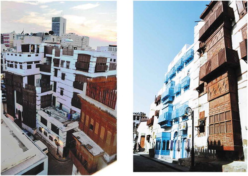
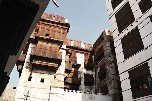
Al-Balad was preserved since the city establishment. Its historical value can be estimated that it has a number of unique and outstanding archaeological, traditional and multicultural structures that exhibit the interchange of human values. In 1509, a wall was constructed around the city by the Mamluk Sultan Al-Ghori so that it can be protected from Portuguese attacks (Bokhari, Citation1983). After oil exploration in the 1950s, the city was needed to expand due to which the old wall was demolished in 1947. It was the only reason that the old Jeddah was preserved. Unfortunately, the planners did not take account its value due to which the historical effects of the Al-Balad region have been suffering from serious and challenging issues (Bagader, Citation2014). The deterioration of historical buildings and the migration of the occupants of traditional houses have become an irretrievable loss of historical character (Figure ).
Figure 1. A view of traditional houses in Old Jeddah (Author).
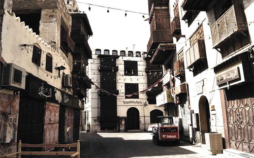
Figure 2. The architectural style in old Jeddah (Author).
2. Cultural heritage and the architectural importance
Internationally, Jeddah got its prominent position when it was decided to make it the port on the Red Sea by the third Muslims caliph Uthman bin Affan for the pilgrimage. Since that time it was serving as the Gateway to “Two Holy Cities” Makkah and Medina. Now it has become the Jeddah Islamic Port and every year thousands of pilgrims and traders of diverse culture and regions are passed from here to perform their rituals and business. Thanks to sea trade and religious obligations, Jeddah has become a hub where diverse cultures and traditions of Red Sea and Indian Ocean are mingled. Jeddah depicts the prominent exchange of human values and cultural world as it has always been acting as a melting pot where Muslims cultures and traditions from Africa and Asia are met with the Arab land and people.
Its worth has become more prominent as it is the only surviving urban region on the Red Sea which possess multicultural unprocurable values that can be compared not only with Arab cites but also with Asia and Africa.
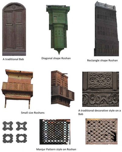
The port position of Jeddah has also affected the architectural style of this region, which has become a diverse architecture of different parts of the world, especially Turkey, Egypt and Syria. Special coral and oriented houses with unique woodwork on the doors, Roshan’s facades (a large window) with Manjour Pattern and Dakkah (the interior of Roshan) are outstanding examples of these incredible structures. These structures are unique with this Arab region. Their attractive Hejazi pattern, big Roshans, lack of the courtyard, the ground floor for rented and office purposes are the best adaptations for the hot and humid climate of Jeddah (Figure ).
3. Rehabilitation projects
In 1947, after the destruction of the Jeddah wall, the threat had appeared that Jeddah will deprive from Historical heritage. In 1977, it was decided to establish Jeddah Municipality which then presented a detailed plan to maintain and develop the historical Jeddah in 1979. In 1980 to 1983, numerous buildings have been restored and the gates of the city were reconstructed to the new gates. In this period, the historical area was also lighted and paved with basalt and granite stone. In 2003, the old Al-Balad house was restored and converted it to museum and offices. King Abdul Aziz project was started in 2005 which adopted the policies to work with heritage structure and to establish the urban development department in historical Jeddah. Global consultant in 2008 restored the heritage buildings and shops. In 3 years project between 2010 and 2013 the main places of historical Jeddah were paved and lighted (SCTA, Citation2013).
Figure 3. Al-Balad District (Author).
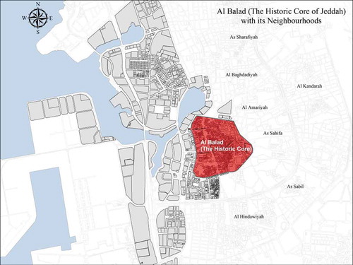
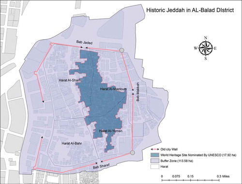
4. Al-Balad district as a world heritage site
SCTA, the Ministry of Rural Affairs and Jeddah Municipality has planned to work jointly in historic Jeddah to develop it and expecting to protect the architectural heritage in the historic territory through some fundamental standards (SCTA, Citation2013). The basic purpose of this joint work is to register the Al-Balad region as a world heritage site which was achieved in 2014 (Figure and ).
UNESCO has declared this region as a world heritage site in 2014. The nominated area by UNESCO spread up to 17.92 ha. It is one-third part of the area encircled by the city wall. This nominated area is the part of the three old quarters, i.e., Sham, Mazloum and Yemen. It is the 1,000 m long and 600-m wide elongate shape which have about 780 buildings. Moreover, a buffer zone of 113.58 ha has been created around this nominated property. This area is nominated due to its most important multi-cultural setting, its unique architectural buildings which exhibit the significant periods of human history and its local culture and traditions which have universal values (SCTA, Citation2013). It is the last cultural centre in this region that still holds its pure urban fabric. In the centre of the most modern city of Jeddah, isolated tower houses, coral stone houses, mosques, ribat-s and souks have occupied a prominent place. It has multicultural inhabitants that play a vibrant role in the economy of Jeddah (SCTA, Citation2013).
Figure 4. World Heritage site nominated by UNESCO (Author).
5. Methodology
5.1. Geo-database development
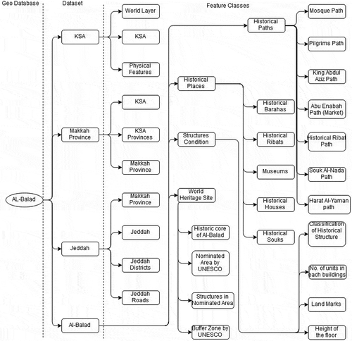
For mapping the historical places, Geographical Information System (GIS) has been selected as it provides a comprehensive framework for capturing, storing analysing and presenting the data (Al-Enazi, Mesbah, & Anwar, Citation2016). After collecting GIS data, it should be arranged in a systematical manner which becomes helpful in analysing and interpretation also it is a most essential step to overcome ambiguities. In GIS, data may be arranged in shapefiles or in the Geo-database. These are two different ways to store the data. Shapefiles have many limitations to store data like the absence of numeric nulls, short field name, etc. Moreover, these are in large size, much slower and messy. A Geo-database is a framework to store GIS Data (Point, Polyline and Polygon layers) in a large file (ESRI). Environmental System Research Institute (ESRI) has forwarded this idea of GEO Database to provide a less messy system of managing the data that have multiple files in many folders.
In this study, maps have been developed to show the historical places of the Old Jeddah. To organize the data in less messy manner a file Geo-database has built up (Figure ).
Figure 5. Geo-database design.
5.2. Data and attribute
Two types of data Geographic and Demographic have been collected for this study. The collected data is in the form of maps, tables, photographs, shapefiles and the descriptive file. Most of the attributes of the data are in the Arabic language which has translated into English so that it can be understood easily by everyone. The geographic data is organized into two groups. The first group contains various points of interest such as the location of Jeddah historical areas, i.e., Haret (quarter), Historical Jeddah houses, Mosques of historical Jeddah, Historical Jeddah Souks and old Jeddah wall gates. The second type of geographic data includes the data which has prepared according to the requirements. The Geo-database data has shown in table
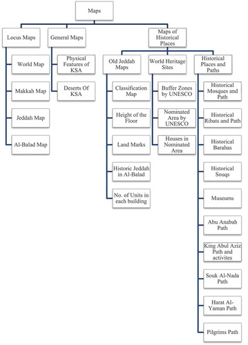
5.3. Map’s classification
To explain the study in comprehensive and brief manager maps are classified into different classes each class representing the type of specific map which it has. Such as local maps showing the position of the specific area with respect to their neighbour this classification does not depend on regions as the geo-database has arranged (Figure ).
Figure 6. Classification of Maps.
5.4. Photographic survey
A photographic survey has been conducted by the author to get the real view of Historical structures (Figure ). A number of pictures have been taken to present the current story of the old Jeddah. These pictures have been used in this study to understand the unique traditional style and historical importance of the old buildings also, these pictures have proved fruitful to make the concepts about the local terms which are used in this old area related to historical places and structure.
Figure 7. Historical structures view (Author).
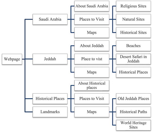
5.5. Online information source
Living in a global village, a website is necessary for promoting everything like a region, culture, heritage, business, etc. For tourism a website is a key source to attract tourists toward a country’s side; without it, we can lose a number of opportunities to promote tourism. A website can accomplish several tasks in the developmental sector and promoting tourism. It is a wide source which can easily access throughout the world than any other advertising source. People want to know about the tourism of a country for that purpose they try to find some easy source. A website can give them all the respective information about those visiting sites which they want to see in a single click. About 80% of the visitors start their tourism journey from the internet. Therefore, a fine-designed and well-maintained website is very necessary to lead in the tourism sector. In this study due to the above importance of website, it had been decided to develop a comprehensive website, which provides valuable information about historical places of Jeddah. The website has been developed which is showing all the necessary information about old places of Jeddah (Figure ).
Figure 8. Structure of the Website.
6. Conclusion
The tourism industry has a great share in the economy of Saudi Arabia. The Government of Saudi Arabia is taking much interest in this sector to promote it. In this regard, a lot of steps have been taken by the government: especially in 2030 vision, they set their aims to pay special consideration in promoting the tourism industry. The city has worth that its tourism industry can grow. Its unique style buildings, traditional souks (Markets), events, historic mosques, ribats (Charity houses) and museums, all these have the eye-catching attractiveness for the tourists. This study has tried to adopt the two best techniques GIS and internet (website) for the promotion of tourism of this ambitious site. The GIS has been used to explore the hidden historical places and insert them on the maps. The maps also have the description about those places so that tourists can easily understand these maps and can finalize their destinations. Website will help them to take brief historical and general information about those places. This website will become a source of all the information about the historical places in old Jeddah. By email marketing, social media advertising, blogging, posting on forums and Search Engine Optimization (SEO) the website will reach in excess of most people shortly.
Cover Image
Source: Author.
Additional information
Funding
Notes on contributors
Riyan Sahahiri
My name is Riyan Sahahiri. I belong to Jeddah, Saudi Arabia. In 2016, I got Bachelor degree in Architecture from King Abdul Aziz University (KAU), Saudi Arabia and then in 2018, I got Master degree in Geospatial Science from RMIT University, Melbourne Australia. I am member of Saudi Council of Engineers. Now I am working as research assistant in KAU. Design and Drawing is my favorite hobby since I was a child.
I have been participating in different training workshops under the Saudi Commission for Tourism and National Heritage for 2012. These training have abled me to understand the tourism industry. I have learned about multicultural environment, heritage and history.
References
- Abdulgani, K. (1993, February). Jeddah: A study of metropolitan change. Cities Magazine, pp: 50–11, London, UK doi:10.1016/0264-2751(93)90114-X
- Abu-Ghazzeh, T. M. (1994). Built form and religion: Underlying structures of Jeddah Al-Qademah. Traditional Dwellings and Settlements Review, pp.49–59.
- Al-Enazi, M., Mesbah, S., & Anwar, A. (2016). Schools distribution planning using GIS in Jeddah City. International Journal of Computer Applications (0975-8887), 138(1), 33–36.
- Al-Fakahani, H. (2005). Jeddah: The bridge of the red sea: Progress and development.
- Bagader, M. (2014). The Old City of Jeddah: From a walled city to a heritage site. WIT Transactions on the Built Environment, 143, 365–374.
- Bokhari, A. Y. (1983). Conservation in the historic district of Jeddah (pp. 60–67). Adaptive Reuse: Integrating Traditional Areas into the Modern Urban Fabric.
- Jeddah Municipality. (2014). Historic Jeddah building regulations & by-laws. Retrieved from http://www.jeddah.gov.sa/english/
- Pesce, A. (1974). Jeddah: Portrait of an Arabian city. ICON Group International.
- Saudi Commission for Tourism and Antiquities website (SCTA). (2014). Retrieved from http://www.scts.gov.sa/
- SCTA. (2013). Heritage Sites in Saudi Arabia, a special report about the heritage sites that registered and nominated to inscribe in the UNESCO WHC, online report on SCTA.com, Riyadh.