
ABSTRACT
Palaeochannels are remnants of rivers or stream channels that flowed in the past and have been currently filled or buried by younger fluviatile sediments. There are a number of techniques for detecting palaeochannels with each of them having its own intrinsic advantages and disadvantages. In the present study, apart from applying different approaches, the capabilities, and effectiveness of the approaches to locate and map palaeochannels are compared. Remote sensing-based approaches are comprised of high-resolution satellite datasets and a LiDAR-derived elevation map for displaying extensive drainage networks of surface feature channels hypothesized to be palaeochannels, palaeorivers, or palaeovalleys. Ground-penetrating radar (GPR) transects along with concurrent visual observations are ground-truthing field approaches and has proved to be one of the most appropriate and accurate methods for locating palaeochannels due to their capability to identify subsurface sedimentary stratigraphy innate to palaeochannels. Nevertheless, visual field observations for ground-truthing of prospective palaeochnnels either exhibiting only subtle alterations in desiccation or vegetation are considered a potent field approach. The present review work lays a strong emphasis on delineation and mapping of palaeochannels using remote sensing, geophysical, and sedimentological techniques to meet the sustainable groundwater development goals.
Introduction
Paleochannel is derived from the word paleo which means old, it is also known with the terms palaeovalley and palaeoriver. The stored geologic remnants of the ancient, old, or nonexistent river that have been dried up because of several climatological or geological elements in the past are termed as palaeochannels (Mohammed-Aslam & Balasubramanian, Citation2010; Vervoort & Annen, Citation2006). Due to environmental changes like differences in land use patterns over the years, weathering, etc. the rivers might have evaporated or gotten wholly covered. As a river bed is seen to be filled with semi-consolidated or unconsolidated sedimentary deposits, a palaeochannel is different. The deposits are not related to the normal bed load of the current course of drainage. The prime components of palaeochannel sediments are gravel and sand deposits and due to their porosity, distribution of water and salt, and modifying transport, as well as high permeability they act as subsurface conduits (Triantafilis & Buchanan, Citation2009). A major concern has been created by the permeable properties of the palaeochannels due to the loss of irrigation water through deep drainage (Wray, Citation2009), whereas the presence of palaeochannels and porous properties are beneficial as sources of groundwater storage (Chen, Xuanqing, Naihua, & Yonghong, Citation1996). There has also been a major concern about limited water availability all over the world, thereby necessitating the identification and spatial mapping of the extents of palaeochannels to enable further detailed studies of the hydrological processes and their significance, that would be an interesting proposition for the improvement of land and resource management practices.
Two types of categories can be seen in Palaeochannels based on their morphologies and fluvial depositional characteristics. Incipiently, Pels (Citation1966) coined the terms ‘prior stream’ and ‘ancestral stream’ to explore the two distinct fluvial-depositional processes that have changed the evolution of the two types of palaeochannels. Nevertheless, based on their studies of surficial stratigraphy, Page and Nanson (Citation1996) recommended replacing the two previous terms that are used to describe the two types of palaeochannels – ancestral stream and prior stream – with two new terms that describe both types of palaeochannels: migrational palaeochannel and aggradational palaeochannel. Furthermore, as these two palaeochannel types can be referred to and reflect their alternating paleo-episodes, it is conjectured that some palaeochannels may be exchanged between both stages of fluvial activity and deposition; namely, laterally migrating channels consisting of lateral accretion, and vertically aggrading channels consisting of vertical accretion (Page, Kemp, & Nanson, Citation2009).
Significance of palaeochannels
An insight into past floodplain activities, paleoclimatic conditions, and estuarine and alluvial depositional responses to prior to sea-level changes can be gained by palaeochannel studies (Kemp & Spooner, Citation2007; Nandini, Sanjeevi, & Bhaskar, Citation2013; Ryan, Bostock, Brooke, & Marshall, Citation2007). Evidence of the past discharge rates and flow regimes as a huge bulk of sedimentary loads is conserved within them (Sylvia & Galloway, Citation2006). Investigation and analyses of the paleo-flow directions and drainage networks of palaeochannels contribute to forming a record of past flood activities which may facilitate the ability to envision potential consequences of future flood events and contribute to flood mitigation strategies. This could be advantageous for regional planning and emergency management actions, especially in the floodplain-dominant regions that are very much populated. By studying the characteristics of the paleochannels and their influences on the subsurface and surficial hydrology one can easily understand the concept of how the paleochannels can determine the current geology and ecosystem responses, drive-specific vegetation speciation and provide evidence for the future ecosystem and geomorphologic responses. In addition, the study of paleo-flow directions of paleochannels and drainage systems enables the ability to speculate potential effects of future flood events and come up with strategies for flood migration by providing a record of the past flood activities. Highly populated areas can also be taken advantage of floodplain-dominant regions’ regional planning and emergency management actions through this study.
Techniques for mapping palaeochannels
Palaeochannels hold immense potential for groundwater and various studies have been conducted using different techniques for mapping these buried channels, which are remnants of rivers that flowed in the past or the channels that have been abandoned by the rivers as they changed their course. All the techniques (remote sensing and GIS, geophysical and sedimentological) discussed below have been found to be extensively useful for the delineation, mapping of these channels, and establishing the fact that fluvial activity was prominent along these channels in the historical times.
Remote sensing and GIS techniques
The science of processing, imagining, and interpreting imagery is remote sensing, and data is received from satellites and aircraft to record interactions between electromagnetic energy through remote sensing (Sabins, Citation1999). Satellite remote sensing and GPR provide almost the same benefits as they both are noninvasive, though it’s the biggest benefit is the ability to cover large areas at fixed regular temporal intervals, allowing for the preparation of continuous archival imagery data for demand and analysis needs.
Landsat satellite imagery can be used to detect the optical and thermal variations in soil properties and characteristics to help understand the locations of palaeochannels via the delineations of their boundaries (Rathore, Nathawat, & Champatiray, Citation2010). As a result, spatial data relating to soil dynamics, soil moisture, and surface geomorphologist is largely acquired by satellite remote sensing; along with the information about the surface drainage regimes and deposition processes (Anderson & Croft, Citation2009; Rossetti, Citation2010; Vereecken et al., Citation2013).
Bhadra et al. (Citation2009), carried out a detailed study on the status of Saraswati Nadi, using satellite data from IRS P6, Awifs, and IRS P6 LISS III. Using these multi-sensor images, they identified and delineated the course of palaeochannels and the current drainage systems in Haryana. They had applied digital image processing techniques, such as histogram equalization, piece/scene wise linear stretching, contrast and brightness enhancement, different band combinations and edge enhancement etc, on satellite images to identify and distinguish the presence of palaeochannels. The delineated palaeochannels were validated with various ground data and collateral information from archeology, sedimentology, hydrology, hydrogeology, rainfall, and petrography.
The identification and mapping of buried palaeochannels can be done with the use of Landsat optical and infrared imagery over large spatial extents without the costs as of GPR and aerial imaging activities (Wray, Citation2009). Besides, Wray (Citation2009) stated that very few studies have taken the benefit of available thermal and optical satellite data for finding palaeochannel and doing their research; particularly the identification of the palaeochannels via soil moisture characteristics that influence ground surface heat transfer properties that can be potentially identified when known visual features combine with thermal band imagery. Furthermore, the free-of-charge availability of all recent and archival Landsat imagery has led to the employment of Landsat data for palaeochannel research without cost which has become particularly advantageous (Zani & Rossetti, Citation2012).
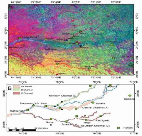
Mehdi, Pant, Saini, Mujtaba, and Pande (Citation2016) used image enhancement techniques (HIS: Intensity, Hue, and Saturation; merging with panchromatic bands; PCA: Principal Component Ananlysis; MCI: Mineral Composite Index, NDVI: Normalized Difference Vegetation Index) for visual interpretation of land cover by differentiating the surface moisture characteristics, highlighting the spectral differences with reduction of noise levels, masking out the densely vegetated areas ().
Figure 1. (A) Principal Component Analysis (PCA) map of the area between Hisar and Kalibangan, highlighting the palaeochannels. (B) Three major palaeochannels under discussion in the paper, as mapped from PCA at A. These are the northern (marked in green), the central (reddish brown), and the southern (red) palaeochannels. (Mehdi et al., Citation2016)
Chaudhary and Aggarwal (Citation2009) and Wang, Guo, Wu, Zhu, and He (Citation2012) demonstrated the practice of combining a geographic information system (GIS) and satellite imagery for identifying and demarcating palaeochannels to find the location and position of sources of groundwater and groundwater recharge within palaeochannels. In addition, Hou and Mauger (Citation2005) carried out a comparative study of the capabilities of thermal and optical remote sensing, elevation datasets, and GIS for identifying and mapping palaeochannels. It was concluded from the latter that draping Landsat satellite imagery over a digital elevation model (DEM) provides a cheaper method of enhancing the visualizations of the terrain of palaeochannel surface morphologies; admitting the requirement of additional methods such as borehole drilling and core analyses to acquire more detailed geophysical knowledge of subsurface palaeochannel structures. The identification of palaeochannels has been eased by such studies thus showing the convenience and effectiveness of remotely sensed satellite imagery initially.
Palaeochannels provide major opportunities for mining and therefore often are sources of economically important commodities (Cudahy & Ramanaidou, Citation1997; Ramanaidou, Morris, & Horwitz, Citation2003). Landsat optical remote sensing imagery is a technology intended for enabling the identification of mineral sites for future mining and also the identification of ores. Analysis of principal components and computation of specific band ratios are included in these image processing techniques, among others, to ease the exhibition of band spectral signatures deep-rooted in the oxides and other earthly resources (Ciampalini, Garfagnoli, Antonielli, Moretti, & Righini, Citation2013; Sabins, Citation1999). The Landsat archive, which is all a newly acquired imagery, has in the recent past years, become available free of charge. Recent activities in mineral exploration research in Australia, however using Landsat, may have seemed advantageous in the recent past for endeavors of exploration, but no significant detail was found in the current literature. The main reason for this unavailability may be because numerous additional satellites offering higher resolution imagery are at disposal regardless of the cost factor.
Light detection and ranging (LiDAR) is another mode of noninvasive remote sensing that can be carried out as a terrestrial ground-based survey that may be comprised of a tripod-mounted scanner sensor, or be carried out with aircraft via aerial laser surveying (ALS) (Rayburg, Thoms, & Neave, Citation2009). The emission of laser pulses toward the target normally at the ground surface by an aircraft-mounted sensor receives the reflected laser signals, which further enable it to calculate the distances between the aircraft and its target, thus aiding in the measurement of terrain elevation points (Jones, Brewer, Johnstone, & Macklin, Citation2007). Larger expanses for measurements of terrain elevation can be surveyed accurately and quickly through LiDAR aerial scanning, which is yet another advantage of the technique. It is widely used for the delineation of floodplain for further processing for surface elevation-related analyses with elevation point-data, which is commonly converted into raster digital elevation models (DEM) (Deshpande, Citation2013). Challis (Citation2011) had earlier observed that when near-infrared (NIR) was emitted in LiDAR surveys, the lower intensity of NIR backscattering (reflectance) was found geographically matching to the locations of ground surface features like palaeochannels, and it was deduced from the former that the higher content of soil moisture was perhaps the cause of this lower-intensity NIR reflectance and variations in organic soil properties, were found to be associated with the sedimentary-fill of palaeochannels. These reported investigations, despite being promising, also imply that areas of higher soil moisture content detected by NIR aerial LiDAR data, may give clues about the locations of palaeochannels, and it is therefore advised to combine the same with LiDAR-derived elevation data. This was found to help examine whether it was fine to correlate the soil moisture data and elevation data. This should provide a tool to enable the detection of palaeochannels, particularly hidden palaeochannels that do not display any surface appearances.
For the analyses of terrain elevation, LiDAR data determine a common dataset which is the digital elevation model (DEM), and a raster dataset, specifically used for the modeling of hydrological surface flows such as flood estimation mapping (Charrier & Li., Citation2012; Jones, Poole, O’Daniel, Mertes, & Stanford, Citation2008). A 3D point-cloud dataset is used to calculate the DEM. It consists of the recorded points of terrain surface contact of the emitted and received laser pulses (Straatsma & Middelkoop, Citation2006). Using filter algorithms, DEMs can produce erroneous elevation data if ground points are not separated from vegetation canopy points, which may lead to the differentiation of bare ground point data from non-ground point data (Straatsma & Middelkoop, Citation2006). However, Hopkinson et al. (Citation2005) stated that the reason for the underestimation of canopy surface DEM data and overestimation of bare ground DEM data can be found due to the penetration of lasers through canopy foliage, especially the low vegetation foliage. As a technique for correcting LiDAR height biases, the establishment of penetration measurements is recommended. It is, however, taken into account that only the penetration measurements which are dependent on vegetation class should be used. The use of airborne LiDAR data and LiDAR-derived DEMs in smooth and level, sparsely vegetated fluvial and alluvial floodplain studies, are used as tools for palaeochannel identification (Budja & Mlekuz, Citation2010; Challis, Citation2011; Chiverrell, Thomas, & Foster, Citation2008; Hohenthal, Alho, Hyyppä, & Hyyppä, Citation2011). Survey of the places where the study of terrain elevation is difficult or there is a lower ground access for the survey of the field, which is often expensive and time-consuming, Airborne LiDAR surveying techniques are often used to ease the process of the analysis of topography. Since there is a regular acquisition of the data obtained from this technology, there is scope to provide an additional tool to combine Landsat and GPR data for palaeochannel exploration.
Remote sensing techniques, like the synthetic aperture radar (SAR) technology, have put forward the scope for the integration of optical data for the location and portrayal of the palaeochannels. Its capabilities also include the sensing of water content and moisture along with identifying features of surface relief and configuration (Bertani, Rossetti, & Albuquerque, Citation2013). The Phased Array type L-band Synthetic Aperture Radar (PALSAR) sensors, for instance, can penetrate the subsurface depending on parameters on the Japanese Advanced Land Observing Satellite (ALOS). These parameters included ground dryness, radar wavelength properties, and subsurface roughness (Khan, Fathy, & Abdelazeem, Citation2014). Although the technique is irrelevant for the floodplain regions which are more homogeneously moist coastal parts of Australia, it is seen to have the capabilities for the detection and delineation of subsurface and surface hydro-spatial characteristics of paleochannels and thus paleochannel delineation would be imperceptible using radar satellite data.
Geophysical techniques
A radar-propagation technology, called Ground-penetrating radar (GPR) is a noninvasive mechanism that can potentially be used to detect differences in subsurface sedimentary structures by aiding the generation of pulses of electromagnetic energy that impart them to penetrate the ground. After this, the exact time of arrival of the reflected frequency waves is collected and calculated (Neal, Citation2004). Distinct subsurface strata and other compositions should be separated through visual differentiation which can be enabled by technology. The device receives electromagnetic signals to study the other compositions including porosity, moisture, and lithologic configurations (Dentith, O’Neill, & Clark, Citation2010; Slowik, Citation2011). Being noninvasive, this method is a highly suitable and time-saving technique for the investigation of buried palaeochannel configurations and boundaries and for assisting the determination of initial sites for detailed core sampling. Although the process is time-consuming and expensive, it is a common technique to combine GPR with the core sampling methods and using GPR for the identification of relevant core drilling sites (Barnhardt & Sherrod, Citation2006; Mallinson, Smith, Culver, Riggs, & Ames, Citation2010; Timmons, Rodriguez, Mattheus, & DeWitt, Citation2010).
If one goes by the earliest-dated studies available in the literature, it may be seen that there is the incorporation of new archeological technology for GPR. For the identification of subsurface remains of an eighteenth-century 100 MHz Electromagnetic Subsurface Profiler was used by Kenyon (Citation1977). Grossman (Citation1980) describes the convenience of applying GPR technology within the fields of engineering and preparation for the detection and subsequent avoidance and preservation of historical archeological sites. The testing of GPR was intended as a new form of non-excavation (noninvasive) surveying and the future planning of excavation works was done by using the results. This was done to investigate an eighteenth-century military encampment, where Parrington (Citation1979) included the nondestructive application of GPR with aerial photographs. Furthermore, originally used for the detection of thin ice during Arctic oil explorations (Kenyon, Citation1977; Parrington, Citation1979) GPR was developed following the aerial radar systems according to the mentioned studies.
The correct interpretation of the acquired reflected features visible in GPR trace file imagery is the key skill that is required for conducting successful GPR research. Grossman (Citation1980) explains that a peculiar application of relatively new GPR technology along with its archeological research can potentially, with its own rules and vocabulary, present before researchers a new visual language, that had to be learned for the translation and interpretation of the GPR data. Later, intending to provide researchers with representative samples, Van Overmeeren (Citation1998) proposed the compilation of a ‘radar facies atlas’ of GPR sedimentary image profiles, to help the researchers enable the comparison and interpretation of radar stratigraphic sections. Furthermore, Neal (Citation2004) came up with recommendations for the need to adopt new terminologies and systematic approaches as an unprecedented medium to improve the interpretation of GPR data and radar stratigraphy. To provide a guide for comparing and interpreting GPR signals representing braided, Slowik (Citation2012) then restated and supported the necessity for a ‘radar facies atlas’ whose first proposal came from Van Overmeeren (Citation1998), to provide for GPR representative data of sedimentary environments. This helped in meandering and transitional river channel systems. An attractive proposition is to compile an atlas-guide of GPR sedimentary images and the interpretation of GPR data, which may later be a highly desirable tool to complement GPR research. However, such a GPR atlas-guide continues to appear in the proposal stage.
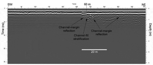
Hambly (Citation2015) conducted GPR transects and acquired promising results with radar reflections of numerous buried channel features along the Mooloolah River National Park within southeast coastal Queensland patterned fen complexes ().
Figure 2. First section of the GPR transect trace file of the park access road traveling northeast. The first visible feature is characterized by the horizontal linear channel-fill stratification. (Hambly, Citation2015)
Various investigations have made use of GPR as a potential method for the determination of the previous native courses of rivers before anthropogenic alterations which may have diverted river channel paths and flows. Slowik (Citation2014) investigated and confirmed that GPR can be used for the discovery and reestablishment of the distribution of various previously unknown natural channels of the Obra River, Poland that led to the change and improvement of channel courses of the river in the past before the construction of hydro-technical works. According to the study within an interrelated system, there has been the identification of substantial evidence of transitions from anastomosing to meandering river flow regimes and lateral migration, along with meandering anabranches. Even though there was no mention of identification or inferences of paleochannels, it also has helped identify previous natural channels of the river. Aerial photographs, historical maps, satellite imagery, and ground core drilling were used to support the GPR study to confirm GPR penetration depths, geophysical properties, and physical sources of radar reflections. Another similar GPR study by Slowik (Citation2013) at the same river site concluded that although the successful discovery of palaeochannels by GPR was reported, it also comprised the same methods used in the 2014 study. Based on such studies, it has been confirmed that, during the GPR research activities, an ensemble of methods is recommended to help confirm the characteristics and geophysical properties of subsurface structures to be detected.
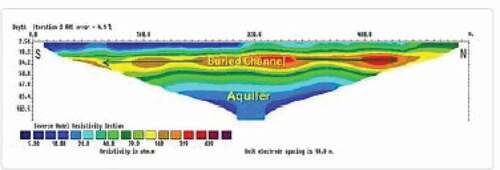
The resistivity values and contrasts are helpful for mapping even the slightest variation in the resistivity of the subsurface formations related to texture, moisture content, and porosity variation of the sand or soil. With the help of the 2-D resistivity tomography dataset, the presence of the buried channels can be easily detected (Kumar, Mondal, Sarma, & Sen, Citation2012) (). The large-scale geometry and architecture of the paleochannel system along the Ghaggar river north-west India were mapped with the electrical resistivity soundings (Khan & Sinha, Citation2019; Sinha, Yadav, Gupta, Singh, & Lahiri, Citation2013). The large dimensions of these paleochannel bodies imply deposits of a large river system.
Figure 3. Shows the 2D inverted resistivity second along Kasaur Site (KA −2) delineating the buried channel anomaly with variable thickness and its lateral extension along with the aquifer zone. (Kumar et al., Citation2012)
Sedimentological/ core logging techniques
The core samples can be used to analyze the physical and chemical properties of stratigraphical studies of palaeochannel sediments. These samples were collected along transects located within transition zones between palaeochannel features and adjacent geology (Triantafilis & Buchanan, Citation2009). Furthermore, preserved Holocene palaeochannels were compared with modern modified channels, and Page, Frazier, Pietsch, and Dehaan (Citation2007) found that it provided a method for the estimation of dates when European settlement began affecting existent natural channel meanders along with the transformation of waterway landscapes. The integration of subsurface optical remote sensing with core sample data and GPR applications has been successful in depiction of the patterns of palaeodrainage and obtaining data on depositional environments (Assine, Corradini, Pupim, Do, & McGlue, Citation2014; Timmons et al., Citation2010). Moreover, the drilling of the subsurface for analyses of core sampling and dating (thermoluminescence and pollen sampling) can be of help to confirm locations and determine ages of concealed palaeochannels and assist in dating and understanding river avulsion events (Timar, Sumegi, & Horvath, Citation2005). Ancient surface processes have to be understood to gain knowledge of where paleochannels are present. Optically Stimulated Luminescence (OSL) dating of subsurface channel-filled samples of paleochannels, can be used to examine the historical alterations to the anthropogenic data in the landscape. Several changes in the morphologies and flow regimes of channels are seen due to extensive modifications in the waterway thus, significantly altering the hydrological processes (Page et al., Citation2007).
Conclusion
Geomorphological records that enable insight into past hydrological processes along with fluvial, depositional, and sedimentary responses that were influenced by such hydrological processes are called Palaeochannels. The forecasting and anticipation of future events can be done by studying past events that can provide knowledge of events, such as potential flood events and catchment responses to climate change implications. This is focused within the floodplain regions. Moreover, palaeochannels have undergone a lot less authoritative research, especially if the knowledge gained could potentially contribute to regional flood mitigation approaches and environmental land management strategies, and there is an assurance of robust incentive to commence such research to help in the planning.
The methods available for palaeochannel studies are not only modern, but also noninvasive – such as optical and radar satellite imagery, GPR, electrical resistivity meter, remote sensing, LiDAR, which is coupled with the analysis of GIS and processing, and provides a suite of tools and methods for paleochannel identification, research, and mapping. The acknowledgment of advantages and limitations is essential to ensure successful research outcomes. Moreover, the combination of these methods with field ground-truthing methods such as visual observations, and ultimately subsurface core sampling analyses on the availability of resources is of great importance for the determination of the physical and chemical properties of palaeochannels.
Correction Statement
This article has been republished with minor changes. These changes do not impact the academic content of the article
References
- Anderson, K., & Croft, H. (2009). Remote sensing of soil surface properties. Progress in Physical Geography: Earth and Environment, 33(4), 457–473. doi:https://doi.org/10.1177/0309133309346644
- Assine, M. L., Corradini, F. A., Pupim, F., Do, N., & McGlue, M. M. (2014). Channel arrangements and depositional styles in the São Lourenço fluvial megafan, Brazilian Pantanal wetland. Sedimentary Geology, 301, 172–184. doi:https://doi.org/10.1016/j.sedgeo.2013.11.007
- Barnhardt, W. A., & Sherrod, B. L. (2006). Evolution of a Holocene delta driven by episodic sediment delivery and coseismic deformation, Puget Sound, Washington, USA. Sed, 53(6), 1211–1228.
- Bertani, T. D. C., Rossetti, D. D. F., & Albuquerque, P. C. G. (2013). Object-based classification of vegetation and terrain topography in Southwestern Amazonia (Brazil) as a tool for detecting ancient fluvial geomorphic features. Computers & Geosciences, 60, 41–50. doi:https://doi.org/10.1016/j.cageo.2013.06.013
- Bhadra, B. K., Gupta, A. K., & Sharma, J. R. (2009). Saraswati Nadi in Haryana and its linkage with the Vedic Saraswati River-Integarted study based on satellite images and ground-based information. Journal of Geological Society of India, 73, 273–288.
- Budja, M., & Mlekuz, D. (2010). Lake or floodplain? Mid-Holocene settlement patterns and the landscape dynamic of the Izica floodplain (Ljubljana Marshes, Slovenia). The Holocene, 20, 1269–1275. doi:https://doi.org/10.1177/0959683610371998
- Challis, K. (2011). Airborne laser altimetry in alluviated landscapes. Archive Prospect, 13(2), 103–127.
- Charrier, R., & Li., Y. (2012). Assessing resolution and source effects of digital elevation models on automated floodplain delineation: A case study from the Camp Creek Watershed, Missouri. Applied Geography, 34, 38–46. doi:https://doi.org/10.1016/j.apgeog.2011.10.012
- Chaudhary, B. S., & Aggarwal, S. (2009). Demarcation of palaeochannels and integrated ground water resources mapping in parts of Hisar district, Haryana. Journal of the Indian Society of Remote Sensing, 37(2), 251–260. doi:https://doi.org/10.1007/s12524-009-0019-5
- Chen, W., Xuanqing, Z., Naihua, H., & Yonghong, M. (1996). Compiling the map of shallow-buried palaeochannels on the North China Plain. Geomorphology, 18(1), 47–52. doi:https://doi.org/10.1016/0169-555X(95)00151-T
- Chiverrell, R., Thomas, G., & Foster, G. (2008). Sediment-landform assemblages and digital elevation data: Testing an improved methodology for the assessment of sand and gravel aggregate resources in north-western Britain. Engineering Geology, 99(1), 12 40–50. doi:https://doi.org/10.1016/j.enggeo.2008.02.005
- Ciampalini, A., Garfagnoli, F., Antonielli, B., Moretti, S., & Righini, G. (2013). Remote sensing techniques using Landsat ETM+ applied to the detection of iron ore deposits in Western Africa. Arabian Journal of Geosciences, 6(11), 4529–4546. doi:https://doi.org/10.1007/s12517-012-0725-0
- Cudahy, T., & Ramanaidou, E. (1997). Measurement of the hematite: Goethite ratio using field visible and near-infrared reflectance spectrometry in channel iron deposits, Western Australia. Australian Journal of Earth Sciences, 44(4), 411–420. doi:https://doi.org/10.1080/08120099708728322
- Dentith, M., O’Neill, A., & Clark, D. (2010). Ground penetrating radar as a means of studying palaeofault scarps in a deeply weathered terrain, southwestern Western Australia. Journal of Applied Geophysics, 72(2), 92–101. doi:https://doi.org/10.1016/j.jappgeo.2010.07.005
- Deshpande, S. S. (2013). Improved floodplain delineation method using high-density LiDAR data. Computer-Aided Civil and Infrastructure Engineering, 28(1), 68–79.
- Grossman, J. W. (1980). Defining boundaries and targeting excavation with ground-penetrating radar: The case of Raritan Landing. Environmental Impact Assessment Review, 1(2), 145–166. doi:https://doi.org/10.1016/S0195-9255(80)80006-0
- Hambly, B. F., 2015. Mapping and characterisation of palaeochannels: A comparison of field and remote sensing-based approaches. (BEnvSc thesis). University of the Sunshine Coast. 1–68.
- Hohenthal, J., Alho, P., Hyyppä, J., & Hyyppä, H. (2011). Laser scanning applications in fluvial studies. Progress in Physical Geography: Earth and Environment, 35(6), 782–809. doi:https://doi.org/10.1177/0309133311414605
- Hopkinson, C., Chasmer, L. E., Sass, G., Creed, I. F., Sitar, M., Kalbfleisch, W., & Treitz, P. (2005). Vegetation class dependent errors in lidar ground elevation and canopy height estimates in a boreal wetland environment. Canadian Journal of Remote Sensing, 31(2), 191–206. doi:https://doi.org/10.5589/m05-007
- Hou, B., & Mauger, A. (2005). How well does remote sensing aid palaeochannel identification?-an example from the Harris Greenstone Belt. MESA Journal, 38, 46–52.
- Jones, A. F., Brewer, P. A., Johnstone, E., & Macklin, M. G. (2007). High-resolution interpretative geomorphological mapping of river valley environments using airborne LiDAR data. Earth Surface Processes and Landforms, 32(10), 1574–1592. doi:https://doi.org/10.1002/esp.1505
- Jones, K. L., Poole, G. C., O’Daniel, S. J., Mertes, L. A., & Stanford, J. A. (2008). Surface hydrology of low-relief landscapes: Assessing surface water flow impedance using LIDAR-derived digital elevation models. Remote Sensing of Environment, 112(11), 4148–4158. doi:https://doi.org/10.1016/j.rse.2008.01.024
- Kemp, J., & Spooner, N. A. (2007). Evidence for regionally wet conditions before the LGM in southeast Australia: OSL ages from a large palaeochannel in the Lachlan Valley. Journal of Quaternary Science, 22(5), 423–427. doi:https://doi.org/10.1002/jqs.1125
- Kenyon, J. L. (1977). Ground-penetrating radar and its application to a historical archaeological site. Historical Archaeology, 11, 48–55. doi:https://doi.org/10.1007/BF03374467
- Khan, I., & Sinha, R. (2019). Discovering ‘buried’ channels of the Palaeo-Yamuna river in NW India using geophysical evidence: Implications for major drainage reorganization and linkage to the Harappan Civilization. Journal of Applied Geophysics, 6, 128–139. doi:https://doi.org/10.1016/j.jappgeo.2019.05.017
- Khan, S. D., Fathy, M. S., & Abdelazeem, M. (2014). Remote sensing and geophysical investigations of Moghra Lake in the Qattara Depression, Western Desert, Egypt. Geomorphology, 207, 10–22. doi:https://doi.org/10.1016/j.geomorph.2013.10.023
- Kumar, D., Mondal, S., Sarma, V. S., & Sen, M. K. 2012. The Structure and dynamics of groundwater systems in northwestern India under past, present and future climates. CSIR-National Physical Research Institute.1-4. CSIR- Annual Report.
- Mallinson, D. J., Smith, C. W., Culver, S. J., Riggs, S. R., & Ames, D. (2010). Geological characteristics and spatial distribution of paleo-inlet channels beneath the outer banks barrier islands, North Carolina, USA. Estuarine, Coastal and Shelf Science, 88(2), 175–189. doi:https://doi.org/10.1016/j.ecss.2010.03.024
- Mehdi, S. M., Pant, N. C., Saini, H. S., Mujtaba, S. A. I., & Pande, P. (2016). Identification of palaeochannel configuration in the Saraswati River basin in parts of Haryana and Rajasthan, India, through digital remote sensing and GIS. Epi, 39(1), 29–38.
- Mohammed-Aslam, M., & Balasubramanian, A. (2010). History of river channel modifications - A review. Journal of Ecology and the Natural Environment, 2(10), 207–212.
- Nandini, C., Sanjeevi, S., & Bhaskar, A. S. (2013). An integrated approach to map certain palaeochannels of South India using remote sensing, geophysics, and sedimentological techniques. International Journal of Remote Sensing, 34(19), 6507–6528. doi:https://doi.org/10.1080/01431161.2013.803629
- Neal, A. (2004). Ground-penetrating radar and its use in sedimentology: Principles, problems and progress. Earth Science Reviews, 66(3), 261–330.
- Page, K., Frazier, P., Pietsch, T., & Dehaan, R. (2007). Channel change following European settlement: Gilmore Creek, southeastern Australia. Earth Surface Processes and Landforms, 32(9), 1398–1411. doi:https://doi.org/10.1002/esp.1481
- Page, K., Kemp, J., & Nanson, G. C. (2009). Late Quaternary evolution of riverine plain paleochannels, southeastern Australia. Australian Journal of Earth Sciences, 56(S1), S19–S33. doi:https://doi.org/10.1080/08120090902870772
- Page, K., & Nanson, G. (1996). Stratigraphic architecture resulting from Late Quaternary evolution of the Riverine Plain, south-eastern Australia. Sed, 43(6), 927–945.
- Parrington, M. (1979). Geophysical and aerial prospecting techniques at Valley Forge National Historical Park, Pennsylvania. Journal of Field Architecture, 6(2), 193–201.
- Pels, S. (1966). Late Quaternary chronology of the riverine plain of southeastern Australia. Journal of the Geological Society of Australia, 13(1), 27–40. doi:https://doi.org/10.1080/00167616608728604
- Ramanaidou, E., Morris, R., & Horwitz, R. (2003). Channel iron deposits of the Hamersley Province, Western Australia. Australian Journal of Earth Sciences, 50(5), 669–690. doi:https://doi.org/10.1111/j.1440-0952.2003.01019.x
- Rathore, V., Nathawat, M., & Champatiray, P. (2010). Palaeochannel detection and aquifer performance assessment in Mendha River catchment, Western India. Journal of Hydrology, 395(3), 216–225. doi:https://doi.org/10.1016/j.jhydrol.2010.10.026
- Rayburg, S., Thoms, M., & Neave, M. (2009). A comparison of digital elevation models generated from different data sources. Geomorphology, 106(3), 261–270. doi:https://doi.org/10.1016/j.geomorph.2008.11.007
- Rossetti, D. (2010). Multiple remote sensing techniques as a tool for reconstructing late Quaternary drainage in the Amazon lowland. . Earth Surface Processes and Landforms, 35(10), 1234–1239. doi:https://doi.org/10.1002/esp.1996
- Ryan, D. A., Bostock, H. C., Brooke, B. P., & Marshall, J. F. (2007). Bathymetric expression of the Fitzroy River palaeochannel, northeast Australia: Response of a major river to sea-level change on a semi-rimmed, mixed siliciclastic-carbonate shelf. Sedimentary Geology, 201(1), 196–211. doi:https://doi.org/10.1016/j.sedgeo.2007.05.018
- Sabins, F. F. (1999). Remote sensing for mineral exploration. Ore Geology Reviews, 14(3), 157–183. doi:https://doi.org/10.1016/S0169-1368(99)00007-4
- Sinha, R., Yadav, G. S., Gupta, S., Singh, A., & Lahiri, S. K. (2013). Geo-electric resistivity evidence for subsurface palaeochannel systems adjacent to Harappan sites in northwest India. Quaternary International, 308-309, 66–75.
- Slowik, M. (2011). Changes of river bed pattern and traces of anthropogenic intervention: The example of using GPR method (the Obra River, western Poland). Applied Geography, 31(2), 784–799. doi:https://doi.org/10.1016/j.apgeog.2010.08.004
- Slowik, M. (2012). Influence of measurement conditions on depth range and resolution of GPR images: The example of lowland valley alluvial fill (the Obra River, Poland). Journal of Applied Geophysics, 85, 1–14. doi:https://doi.org/10.1016/j.jappgeo.2012.06.007
- Slowik, M. (2013). GPR and aerial imageries to identify the recent historical course of the Obra River and spatial extent of Obrzanskie Lake, altered by hydro-technical works. Environmental Engineering Science, 70(3), 1277–1295.
- Slowik, M. (2014). Reconstruction of anastomosing river course by means of geophysical and remote sensing surveys (the Middle Obra Valley, western Poland). Geografiska Annaler: Series A, Physical Geography, 96(2), 195–216. doi:https://doi.org/10.1111/geoa.12042
- Straatsma, M., & Middelkoop, H. (2006). Airborne laser scanning as a tool for lowland floodplain vegetation monitoring. Hydrobiologia, 565(1), 87–103. doi:https://doi.org/10.1007/s10750-005-1907-5
- Sylvia, D. A., & Galloway, W. E. (2006). Morphology and stratigraphy of the late Quaternary lower Brazos valley: Implications for paleo-climate, discharge and sediment delivery. Sedimentary Geology, 190(1), 159–175. doi:https://doi.org/10.1016/j.sedgeo.2006.05.023
- Timar, G., Sumegi, P., & Horvath, F. (2005). Late Quaternary dynamics of the Tisza River: Evidence of climatic and tectonic controls. Tectonophysics, 410(1–4), 97–110. doi:https://doi.org/10.1016/j.tecto.2005.06.010
- Timmons, E. A., Rodriguez, A. B., Mattheus, C. R., & DeWitt, R. (2010). Transition of a regressive to a transgressive barrier island due to back-barrier erosion, increased storminess, and low sediment supply: Bogue Banks, North Carolina, USA. Marine Geology, 278(1), 100–114. doi:https://doi.org/10.1016/j.margeo.2010.09.006
- Triantafilis, J., & Buchanan, S. (2009). Identifying common near-surface and subsurface stratigraphic units using EM34 signal data and fuzzy k-means analysis in the Darling River valley. Australian Journal of Earth Sciences, 56(4), 535–558. doi:https://doi.org/10.1080/08120090902806289
- Van Overmeeren, R. (1998). Radar facies of unconsolidated sediments in The Netherlands: A radar stratigraphy interpretation method for hydrogeology. Journal of Applied Geophysics, 40(1), 1–18. doi:https://doi.org/10.1016/S0926-9851(97)00033-5
- Vereecken, H., Huisman, J., Pachepsky, Y., Montzka, C., van der Kruk, J., Bogena, H., … Vanderborght, J. (2013). On the spatio-temporal dynamics of soil moisture at the field scale. Journal of Hydrology, 516, 76–96.
- Vervoort, R., & Annen, Y. (2006). Palaeochannels in Northern New South Wales: Inversion of electromagnetic induction data to infer hydrologically relevant stratigraphy. Soil Research, 44(1), 35–45. doi:https://doi.org/10.1071/SR05037
- Wang, X., Guo, Z., Wu, L., Zhu, C., & He, H. (2012). Extraction of palaeochannel information from remote sensing imagery in the east of Chaohu Lake, China. Frontiers in Environmental Science, 6(1), 75–82.
- Wray, R. A. (2009). Palaeochannels of the Namoi River Floodplain, New South Wales, Australia: The use of multispectral Landsat imagery to highlight a Late Quaternary change in fluvial regime. Australian Geographer, 40(1), 29–49. doi:https://doi.org/10.1080/00049180802656952
- Zani, H., & Rossetti, D. (2012). Multitemporal Landsat data applied for deciphering a megafan in northern Amazonia. . International Journal of Remote Sensing, 33(19), 6060–6075. doi:https://doi.org/10.1080/01431161.2012.677865