
ABSTRACT
The explosion of map use in the past few decades as part of everyday activities, accelerated through the digital production and dissemination of maps and the availability of low-cost, location-aware devices, has made the job of cartographers and map display designers more challenging. Yet, how do these recent changes affect effective map design? Can we accurately predict which designs will work for a given context? We investigate the concepts of design transferability and context and their potential to help us create map design outcomes that are effective for varying map use situations. We then present a model for operationalizing map use context to support evaluating map design transferability and pose several open research questions that need to be answered to support operationalizing map use context. This is followed by a research agenda that identifies research opportunities related to key research needs that will underpin transferable map design.
RÉSUMÉ
L'explosion durant les dernières décennies de l’utilisation de cartes comme activité quotidienne, accéléré par la production et la diffusion numériques de cartes et la disponibilité de dispositifs de localisation peu chers, a rendu plus difficile le travail des cartographes et des concepteurs de cartes. Alors se pose la question de savoir comment ces changements récents impactent la conception de cartes efficaces. Peut-on précisément prévoir quelle conception fonctionnera pour un contexte donné? Nous questionnons les concepts de transférabilité de conception et de contexte, ainsi que leur potentiel, pour nous aider à créer des résultats de conceptions de cartes qui sont efficaces pour des usages diversifiés de cartes. Puis nous présentons un modèle pour rendre opérationnel le contexte d’utilisation de cartes pour évaluer la transférabilité de la conception de carte et poser certaines questions ouvertes de recherche qui attendent des réponses pour l’opérationnalisation du contexte d’utilisation de carte. Enfin nous présentons un agenda de recherche qui identifie les opportunités liées aux besoins prioritaires pour avancer sur le concept de transférabilité de la conception de carte.
KEYWORDS:
1. Introduction
The explosion of map use in the past few decades as part of everyday activities, accelerated through the digital production and dissemination of maps and the availability of low-cost, location-aware devices, has made the job of cartographers and map designers more challenging (Griffin & Fabrikant, Citation2012). We used to design for just one static map medium: paper. In comparison to today, where the general public can access maps almost anywhere and at any time of day (given the necessary resources), maps not too long ago were more often consumed by domain professionals, most typically inside, with the required permission to access them, the necessary income to afford their purchase, and with the luxury of time to pore over them. The digital distribution of maps over the Internet has greatly increased the potential, albeit unevenly, for anyone to use and create maps (Graham, Hale, & Stephens, Citation2012). Despite this unevenness, a larger number of people with a wider range of individual differences, background knowledge, and training are using and creating maps. New technology has enabled trained cartographers to design maps for many more map use situations (e.g. maps for mobile, location-aware devices to be used on the go; immersive wall displays for collaborative decision-making; desktop displays; online; offline; responsive maps; etc.). We also have the possibility to develop algorithms for map design, and work with increasingly voluminous data sources, often of uncertain provenance, sometimes updated in real time (Robinson et al., Citation2017); unimaginable even 50 years ago.
Yet, how do these recent changes affect effective map design? Can we predict which designsFootnote1 will work for particular use situations (i.e. contexts)? We take context to include information about who is using the map (the map user), where the map is being used (the environment), what is being done with the map (the activity), and the graphical object itself (the map). Even early perceptual studies showed that contextual factors, such as using different map production technologies (e.g. tint screening versus laser printing),Footnote2 produce different requirements for effective map design (Griffin & Montello, Citation2015). While understanding how and why a given factor affects performance is useful and even desirable, realistically, making highly reliable and accurate design predictions often requires more knowledge than we currently have about human map use. Moreover, a complete model of map use will likely result in conflicting design requirements that cannot be resolved, but only traded-off by the designer (Petchenik, Citation1983).
Carefully controlled studies can help to pin down some of the relationships between all of the potentially relevant factors and the mechanisms by which they influence human map use performance. Because our knowledge of these relationships in all possible use contexts is limited, there may be some value in considering the concepts of transferability and relevance to improve map design efficacy in different use contexts. Transferability is an idea with roots in qualitative research, in which researchers seek to understand the contexts to which the results of their research might be transferred, rather than generalized to all contexts (Lincoln & Guba, Citation1985). Many qualitative researchers use the concept of transferability (among other criteria) to judge the quality of case-based qualitative research. Its counterpart in quantitative research is external validity, or generalizability (Hoepfl, Citation1997), yet it differs in its overt attention to the bounds of generalizability, bounded rather than universal. Qualitative researchers operationalize transferability by providing a rich description of context, so that readers of the research can judge the degree of similarity between the reported context and their own research case studies.
Expert cartographers, with tacit knowledge about cartographic design principles, are able to make map design trade-offs using context information implicitly; a result of designing many maps for use in different situations. Yet some maps are made by non- or less-expert designers, who often mostly learn from seeing other maps. The number and design quality of maps that less-expert designers have seen may vary. Hence, some map designers may be more informed than others. Yet is looking at and designing many maps the only way to improve map design expertise? For a time during the early days of computing, it seemed as though expert systems might provide an answer (Pfefferkorn et al., Citation1985). After decades of effort and research, some national mapping agencies have in fact recently managed to completely automate the design of particular map series (Howard, Blick, & McNamara, Citation2009). Nevertheless, there is no expert system that will automatically generate an acceptable design for all map use contexts. This is perhaps because design experts are unable to express their knowledge in a concise set of rules or facts that could be simply followed by a computer, or even a less-expert designer (Lawson & Dorst, Citation2009). Indeed, in a series of interviews Tolochko (Citation2016, p. 58) undertook with expert cartographers who design web maps, one designer stated: ‘I can tell it’s a well-designed map when I see it, but I don’t know exactly why.’ We propose that the concepts of transferability and context can be harnessed to structure tacit design knowledge and to provide guidance without being overly prescriptive or simplistic. Rather than looking at the search space of all maps for design guidance and inspiration, it can narrow the focus to maps that share key contextual characteristics. For more expert designers, such an approach may provide guidance about to which aspect of a design the designers should devote their limited resources (typically time) when exploring different design solutions.
What do we need to understand to be able to successfully identify which designs or which aspects of designs will transfer from one context to another? Do we need to describe all possible context information? Are some pieces of context information more important for understanding some map use situations than for others? In other words, how relevant are particular pieces of context information for a given map use situation? These are as yet unanswered questions.
Should we agree that the concept of transferability has merit for map design, a key open research question then is: Which contextual information is relevant for making reasonable judgments about whether a particular design solution, developed for one map use situation, might be transferable to another?
In the following sections, we consider the merits of transferability and the preconditions necessary to determine whether a design would be transferable. First, we clarify the concept of transferability, which underlies our proposed approach for improving the map design process. Second, we define our concepts of context and relevance, and introduce a general model that allows us to operationalize context within cartography. Third, we examine some ways context impacts upon each of the model’s four components—the map user, the map use environment, the map use activity, and the map itself—which in turn shape the design solution space for a particular map use situation. Finally, we illustrate how context, relevance, and transferability can be applied situationally. Across each of these sections, we identify research opportunities that can progress our understanding of context and how this knowledge can improve our map design processes.
2. How can we judge whether a design is likely to be transferrable?
In a design discipline, such as cartography, design transferability is about leveraging one or more aspects of an existing design for a new application or map use situation (Ruecker, Radzikowska, & Sinclair, Citation2011, p. 23). The goal is not generating or finding a generalizable design that will work for all possible applications. Rather, the goal is to be able to modify a design so that it functions effectively in a given map use situation. Identifying needed design modifications requires understanding the particularities of the map use situation and how they may differ from the situation for which the original design was developed. Importantly, it is the cartographer who modifies the original design who must judge the extent to which the design is transferrable to the new situation. Yet, a precondition for confidently making such judgments is that the original designer or design process provides sufficient contextual information about the map use situation. In the face of not knowing a priori which context information about a map use situation will be important for a future modification use of the design for a new situation, what should be captured?
Thus, a second open research question is: How can we best structure or model context information so that it supports judgments of transferability? Does the needed amount of context information to make transferability judgments differ between expert and novice cartographers?
We could also consider clinical practice in medicine, in which medical professionals must make informed judgments about how to apply clinical guidelines to the specific patient, many of whose individual differences and embedded social circumstances may vary in important ways from those of patients who participated in the clinical trials that led to the published research (Pearson, Citation2013). The field of implementation science studies how research produced by experts gets implemented in a particular situation by practitioners or policy-makers who are working within political realities and with different levels of motivation. Thus, a central focus of the field is on how context affects the implementation of evidence-based interventions. While health practitioners do not yet have all the answers to how context affects their practice, they have suggested that action research methodologies originally developed by organizational development scientists, with their focus on real-world contexts, might be a fruitful approach (Glasgow et al., Citation2012).
Judging the transferability of a design requires an understanding of the contextual circumstances shaping a particular map use situation. If our end goal for transferability is the improved implementation of design solutions, we must first understand what we mean by context and its role in cartography.
3. Context and its role in cartography
One oft-cited definition of context states,
context is any information that can be used to characterize the situation of an entity. An entity is a person, place, or object that is considered relevant to the interaction between a user and an application, including the user and applications themselves. (Abowd et al., Citation1999, p. 305)
Although context plays a significant role in all aspects of map research, design, and use, cartographers do not subscribe to a common definition of it, nor do they agree upon how it should be modeled. It is not a prominent topic of discussion within the literature. For example, in the 2009 research agenda of the International Cartographic Association (ICA) (Virrantaus, Fairbairn, & Kraak, Citation2009) and its 2012 follow-up (Moellering, Citation2012), map users, map design, and usability merited considerable attention, whereas context received no mention at all. Presumably, cartographers are well aware of the importance of context, and yet there is no evidence that any effort to define and formalize context (e.g. MacEachren et al., Citation2004; Sarjakoski & Sarjakoski, Citation2008; Schlichtmann, Citation2009; Tomaszewski, Citation2008; Tomaszewski & MacEachren, Citation2012) has gained traction within the broader community. As such, we continue to lack effective, consistent strategies for describing context and implementing our understanding of it to solve design problems.
Tomaszewski (Citation2008) and Tomaszewski and MacEachren (Citation2012) conceptualize context as a product of human reasoning processes used to filter, constrain, and provide meaning to all information arising from a situation; the specific information used to represent context is termed context information, for which there are two descriptive categories, contextual (information that provides context) and contextualized (information given meaning through context). Taking the view that context is an emergent, dynamic property of map use (adapted from Chen & Atwood, Citation2007; Dourish, Citation2004), we propose that distinct map use contexts emerge from individual map use situations. In this approach, map use is the situation, and context information emerges from the interaction of four components: the map user, the map use environment, the map use activity, and the map itself ().
Figure 1. A model for operationalizing map use context to support evaluating design transferability. The left image shows how context information emerges through the interaction of four situational components (map, user, activity, environment). The right image visualizes emergent context information as a triangular pyramid; context nearer the apex is considered more relevant.
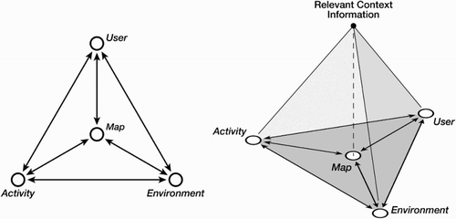
The challenge then, as noted by Tomaszewski and MacEachren (Citation2012), is to implement a model that is neither impractical nor too general to be useful. Map use situations are unique, but it is impractical, if not impossible, to model all possible context information within a particular use situation; however, if the model generalizes too much, ignoring the uniqueness of each use situation, it loses its utility. In , we present a model that we believe can be used to operationalize context without being either too specific or too general.
Each model component is an essential part of a map use situation: the user (e.g. individual differences, capabilities, mental states), the environment (e.g. the setting of the map use), the activity (e.g. purpose for using the map, actions undertaken while using the map), and the map (e.g. representation design, nature of data, display device, interface). Importantly, this model is not conceived as a one-size-fits-all model of map use, but as a tool to facilitate the comparison of map use situations and to support evaluation of design transferability.
Our proposed model provides a mechanism to organize the context information emerging from a given map use situation. The expectation is that this model will help determine which contextual information is necessary to compare two distinct use situations, and then extract from that information the most relevant factors. Importantly, we do not have to compare every contextual factor, only those most pertinent to the map use situation. And so, we draw upon another concept, the relevance of contextual factors.
In seeking effective design solutions, the cartographer must answer two questions: (1) What are the relevant contextual factors that emerge from two map use contexts? (2) What do these contextual factors tell us about the transferability of a particular design solution? Just as context filters and constrains situational information, the relevance of contextual factors acts as a selection filter to reduce context information to its most essential and salient factors ().
Figure 2. The basic function of our context model. As conceived by Tomaszewski and MacEachren (Citation2012) (left figure), context is produced from situational information via human reasoning processes. Likewise, we posit that context is produced from information that arises from a map use situation (right figure); relevance of contextual factors is the selection filter used to determine which context information is essential.
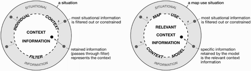
The contextual circumstances surrounding map use situations are potentially limitless; evaluating all of them is both impractical and unnecessary. By first identifying what is contextually relevant about two situations, and then determining their congruence, we can evaluate the applicability of a particular design solution. Within our proposed model, for context information to be relevant it must directly affect the map’s design, and the user’s ability to use the map for the map use activity for which the map is being designed. In emphasizing the concept of relevance of contextual factors, we can confirm key similarities or reveal key dissimilarities necessary to make transferability decisions, or modifications to existing designs. This is perhaps the greatest benefit of emphasizing transferability and relevance of contextual factors within our context model: the identification of essential context information as it emerges from the components of context.
Ideally, the model can also be used to build toward developing design processes that identify design solutions that are transferrable despite changes in context information among map use situations. Sarjakoski and Sarjakoski (Citation2008) presented a similar model in their investigation of the roles of adaptiveness and context sensitivity specific to adaptive map design; in their model, map adaptation is controlled by context parameters. While our context model and notion of transferability are applicable but not limited to adaptive technologies, successful design remains predicated on identifying the relevant contextual parameters of a given situation.
If we seek transferable design solutions, then here our model of context must be allowed to become more explicit so we can position various contextual factors as they emerge, and thus predict, cope with, or determine how to meet a particular design challenge. Although we may not know a priori which specific factors will emerge in a given context, we can use our understanding of how context manifests within and between each component in the context model to compare the two map use situations, and predict the viability or transferability of a particular design solution.
While we have proposed this model of context, we have not yet put it into practice or evaluated its utility. Thus, a third open research question is: What are the reliability and validity of the proposed context model? Does it produce usable and useful results?
Next, we examine each of the four components of our context model and identify opportunities for research that will extend our understanding of that contextual component, with the aim of improving the chance that the context model can be used to produce useful results.
4. Context and map users
Empirical cartographic design research conducted with map users has some tradition of studying the role of individual differences in map reading, interpretation, and use (Montello, Lovelace, Golledge, & Self, Citation1999). For example, there have been studies that have looked at the role of sex in map reading (Lloyd & Bunch, Citation2005, Citation2008), color vision impairment and successful map use (Olson & Brewer, Citation1997), or the role of expertise of various types in successfully using maps (Lloyd & Bunch, Citation2005; Roth, Citation2009). There is thus some understanding that to provide effective visualizations, cartographers need to pay attention to these individual differences, either in terms of modifying the design of the visualizations themselves or in training users to use them more effectively (Davies, Fabrikant, & Hegarty, Citation2015). Individual differences are an essential component of context because they shape the design solution space. Use of a spectral color scheme is likely to cause problems for many color vision impaired map readers, for example. In this section, we focus on identifying research opportunities related to individual differences that we believe need more research attention: spatial abilities, disability, the relationship between individual differences and affective and emotional responses to maps and spatial information, and systematizing individual difference definitions.
4.1. Spatial abilities
One individual difference that has received increased research attention recently is a category of related abilities generally grouped as ‘spatial abilities’, for example, those found at SILC (Citation2016). A number of researchers have demonstrated their importance in successful use of maps to complete a variety of types of tasks, ranging from navigation to a route planning task (Maguire et al., Citation2000; Wilkening & Fabrikant, Citation2011). It is clear that training and practice can improve spatial abilities (Uttal et al., Citation2013) and that doing so actually changes the structure of an individual’s brain, as demonstrated by the well-known study of London taxi drivers (Maguire et al., Citation2000; Woollett & Maguire, Citation2011).
The general public now experiences maps as nearly ubiquitous. They are spending more time using maps of all kinds, but in particular, maps that help them to navigate from place to place, including those found in GPS navigation tools. While these kinds of applications can facilitate people’s daily activities and decision-making, they potentially bring some detrimental effects. As mentioned by Montello (Citation2009, p. 1835), ‘technologies change how we think, often by reducing our ability to reason effectively without the technology’. Therefore, there is a strong need to understand the potential side effects of over-reliance on these technologies. Just as practice can improve our spatial abilities, if we fail to use them, they can atrophy. There are several initial studies hinting in this direction, and they show that over-reliance on navigation systems actually harms our spatial abilities and spatial knowledge acquisition (Aporta & Higgs, Citation2005; Gardony, Brunyé, Mahoney, & Taylor, Citation2013; Huang, Schmidt, & Gartner, Citation2012; Ishikawa, Fujiwara, Imai, & Okabe, Citation2008). However, until now, a systematic understanding of these issues and their relationship to other individual differences is still missing, and very challenging, as it requires longitudinal empirical research.
Opportunity #1: How is spatial ability affected by spatially enabled devices? How can we design technologies that facilitate users’ activities and decision-making and augment rather than harm their spatial abilities?
4.2. Disability
Maps are no longer simply seen; they are heard, they change over time, and they are interactive (Krygier, Citation1994; MacEachren, Citation1995; Maggi, Fabrikant, Imbert, & Hurter, Citation2016; Magnusson et al., Citation2009). Maps are often multi-sensory devices that require users to see, hear, and move in ways they have not done previously. Perhaps the best-studied disability within research on map design is vision impairment (Brock, Citation2013; Lawrence & Lobben, Citation2011; Lobben & Lawrence, Citation2012). Today’s cartographers have to take into account not only visual impairments, but also other physical and mental disabilities that prevent all users from interacting with maps in exactly the same way. In some situations, new forms of map interaction (e.g. voice-controlled interaction or sonified maps) may make maps more, rather than less, accessible for map users with particular forms of disability (Brock, Truillet, Oriola, & Jouffrais, Citation2014; Brock, Truillet, Oriola, Picard, & Jouffrais, Citation2015; Loomis, Golledge, & Klatzky, Citation1998).
While not traditionally considered a disability, illiteracy in today’s world certainly places strong limits on what many would consider to be ‘normal’ activities. Despite improvements in access to education in many countries, there are still many people who cannot read, and this affects how they are able to use maps, not only for navigation-related activities, but also as geoinformation repositories that can support decision-making (Vitos, Lewis, Stevens, & Haklay, Citation2013). The advances in GI technology that allow people to access interactive maps, such as Google Maps, Microsoft Maps, or OpenStreetMap, make it possible for illiterate people to use maps. However, their map reading and map use skills may operate quite differently to those of literate people. Therefore, it is important to direct research to understanding whether some map reading skills are common among most illiterate people. With attention to this individual difference, we can design interfaces to enable users of all literacy levels to benefit from access to geoinformation (Medhi, Sagar, & Toyama, Citation2006; Stevens et al., Citation2013).
Opportunity #2: How can we design to extend the benefits of interactive maps to people with various forms of disability or levels of literacy?
4.3. Affective and emotional responses and individual differences
Cartographers have studied the perceptual and cognitive processes involved in using maps and other forms of spatial information for decision-making. Yet there are gaps in this understanding, especially in understanding how emotions interact with these processes (Schwartz & Bless, Citation1991) and the relationships among perception, cognition, affect/emotion, and individual differences such as personality traits (Thoresen et al., Citation2016) and attitudes. While some early work suggested that map designers should aim to induce positive affective responses in map users who are in a stressful situation (Meng, Citation2005), compared with other aspects of map design, there has been only a small amount of work on emotion and maps (Fabrikant, Christophe, Papastefanou, & Maggi, Citation2012). Much of this research has looked at spatially representing emotion or using maps to collect information about emotions (Griffin & McQuoid, Citation2012). Little work has been done to assess emotional responses to maps, or how these responses interact with analytical reasoning processes, and the work that exists has largely involved theoretical studies rather than empirical measurement of map readers’ emotional responses (but see Frei, Richter, & Fabrikant, Citation2016; Maggi et al., Citation2016). Other types of visual stimuli have been shown to arouse emotions in ways that are designed to change people’s attitudes and behaviors (Joffe, Citation2008; Lang, Greenwald, Bradley, & Hamm, Citation1993). Persuasive and emotive images and graphics are also linked with greater levels of attention, meaning evocative visuals grab attention.
Opportunity #3: How are individual differences associated with affective and emotional responses to maps? Which design factors are effective in arousing emotional responses that lead to a map user changing his or her attitudes and behaviors?
4.4. Systematizing individual difference definitions
The importance of thinking about individual differences between map users has been recognized for some time – it was also one of the research challenges identified in the 2001 geovisualization research agenda (Slocum et al., Citation2001). Yet, White’s (Citation2015) systematic review of individual abilities, behaviors, and characteristics reported in 108 cartographic user studies showed that there is wide variation, at least among English-language cartographic research, in attention to individual differences. For example, while he found that almost two-thirds of studies reported sex and age, other potentially relevant variables (e.g. map reading experience) were less frequent, and still others were rarely studied (e.g. spatial abilities, color vision impairment). While clearly not all individual differences might be relevant factors in a given map use context, it is curious that there has not been more progress in understanding the role of individual differences other than those of sex and age. Another key issue is that researchers often do not operationalize individual difference definitions in the same way, making it difficult to explore the domain generality and consistency of differences that are found to be important for map reading (White, Citation2015).
Opportunity #4: Systematize individual difference definitions to allow studies to be more easily comparable and support meta-analysis of individual difference effects.
5. Context and map use environment
Context also includes non-human factors, and it is important to realize that although in some situations, users have choices about where activities are undertaken, in other use situations, the activity is constrained to specific settings (e.g. maps to support sports and leisure activities, an interactive map kiosk in a museum). Map users now have devices that make maps available to them at any time, and they view and read maps in places we never before imagined they would. The environment(s) in which maps are used shape the design solution space, and relevant contextual information may vary substantially between physical use environments. For these reasons, we focus on two primary research opportunities: first, modeling context information that emerges from the physical environment or ‘location’ of a map use, and second, understanding the role of distracting environments and how they affect a map’s design and use.
5.1. Physical environment characteristics
Factors describing the physical environment of map use might include lighting, temperature, weather conditions, noise level, or position in the surrounding landscape. Today, these factors can be easily captured and monitored during map use with smart mobile devices that are already equipped with a variety of sensors. The user may have the ability to control some aspects of the physical environment, but not others. For example, if standing in bright sunlight that renders the map unreadable on their device, the map user may be able to move to a shaded area or the map display may adapt autonomously. Yet other factors, such as air temperature, or the need for protective equipment in a hazardous environment (e.g. for firefighting), might be less easily changeable. Temperature might affect outdoor use if users are wearing gloves – in such a context, they might prefer to give input via a voice command instead of using a touchscreen. Weather conditions might also affect the content that should be displayed in the map, depending on the map use activity. A position on a hill might enable a map user to get an overview of an area to orient herself, whereas orientation in a forest requires very detailed information about what is adjacent to the map user because visibility might be limited.
Opportunity #5: Develop a model of physical environment context factors and how they can affect successful map use.
5.2. Distraction
Map user performance may be negatively affected in high-distraction environments such as loud environments, poor weather conditions, or other high-distraction environments. Map users are often forced to use maps in high-distraction environments (Hernández et al., Citation2011; Prasanna, Yang, & King, Citation2013). The design of some maps has changed to ensure that they are used effectively during times of high cognitive load. For example, in-vehicle navigation devices use sound to avoid the user having to constantly look at the device.
Opportunity #6: Determine how varying types and amounts of distraction require maps to be redesigned; is there some common threshold among differing types of distracting environments?
6. Context and map use activity
Map use activities arise from interactions of users with maps. Any consideration of map use activities and context must examine the activities themselves; the characteristics of these activities and when they occur may be important determinants of the effectiveness of a particular design solution. Here, we describe a number of factors of context related to map use activity that we believe may be important to know more about, including the creation of a task taxonomy for interactive cartography, the potential for behavior profiling to help us understand activities, temporal dimensions of map use activities, and activities that require the collaborative use of maps.
6.1. What is being done?
Various task taxonomies have been developed by different groups in different disciplines, for various purposes (e.g. Board, Citation1978; Davies, Citation1995; Roth, Citation2012; Shneiderman, Citation1996). Roth (Citation2012) probes the reasons why there have been dozens of taxonomies produced, many of which contradict each other. Most taxonomies stem from an era where display use and interactions related mainly to windows–icons–menus–pointer (WIMP) interfaces used indoors on static display devices. Today’s display devices offer many more activities and types of interactions with the map display (i.e. virtual reality goggles, augmented reality, touchscreens, etc.), therefore such taxonomies need to be further developed. The lack of a commonly used, agreed upon task taxonomy makes it more challenging to determine if tasks in multiple experiments are similar enough to be comparable. Clearly, the challenge of determining comparability (and thereby the potential for transferability) increases with the complexity of a task. Simple, low-level tasks (e.g. finding the state with the highest voter turnout) are more likely to be well understood and well defined when compared to high-level, multi-step tasks (e.g. detecting potential pirates by comparing a specific ship’s behavior to the ‘usual’ behavior of a fishing ship).
Opportunity #7: Develop a comprehensive composite task taxonomy to describe map use tasks for interactive cartography and promote its adoption and use among researchers.
6.2. When is an activity being done?
Map use activities sometimes take place at particular times. Time might affect the design of maps by affecting what type of information is relevant for the activity the map is supporting (Reichenbacher, Crease, & De Sabbata, Citation2009; Reichenbacher, De Sabbata, Purves, & Fabrikant, Citation2016). For example, in summer and winter seasons, a useful map in national parks could be quite different (e.g. in cold areas, users can ski on lakes in winter, while in summer the lakes are used for swimming). Thus, points of interest or routes displayed in the maps might differ greatly depending on the time at which the map is used (Nivala & Sarjakoski, Citation2003). Time of day might also be relevant (Kettunen, Putto, Gyselinck, Krause, & Sarjakoski, Citation2015). Many LBS, for example, show only nearby options with availability at the time of search (e.g. restaurant reservation apps). In-vehicle navigation devices commonly use different map designs for daytime and nighttime driving to make it easier to quickly extract important information from the display. This could also include content if a nighttime map displays only those landmarks that are visible at night (Raubal & Panov, Citation2009). Time of day might also be relevant to the suggestion of the actual route itself, with many navigation devices now including live traffic congestion information, and suggesting alternative routes if the ‘fastest’ route is affected by heavy traffic.
Opportunity #8: Develop a model of temporal contextual factors relevant to successful map use.
6.3. With whom is an activity undertaken?
Map use activities can be undertaken by individuals or by groups of users when they are collaborating. These groups of users may or may not be working synchronously and/or in the same place (MacEachren, Citation2001). Asynchronous or different-place collaborations may present the most design challenges as it may be important to communicate what has been done with or changed in the map to other members of the group. While there was a spurt of research on supporting collaboration with maps in the early 2000s (e.g. MacEachren, Citation2000, Citation2001) and the theme featured prominently in the 2001 Geovisualization research agenda (Slocum et al., Citation2001), the theme seems less prominent in the cartographic literature in recent years although some exceptions such as Jones, Haklay, Griffiths, and Vaughan (Citation2009) and An et al. (Citation2014) exist. Yet, a healthy level of interest in the topic persists in related disciplines such as information visualization and visual analytics (e.g. Chen, Alsakran, Barlowe, Yang, & Zhao, Citation2011; Donalek et al., Citation2014; Hajizadeh, Tory, & Leung, Citation2013; Isenberg et al., Citation2011; Mahyar, Sarvghad, & Tory, Citation2010; Wu, Convertino, Ganoe, Carroll, & Zhang, Citation2013). This is a curious turn of events given that the growth of Web 2.0 technologies such as Twitter or Facebook and VGI have arguably greatly increased the level of collaboration worldwide on geospatial problems.
Opportunity #9: What constraints do time and location place on the design of map-based Web 2.0 collaborations? Do extant map collaboration tools support them effectively, or are new tools and techniques required?
6.4. Behavior profiling
While many of the activities for which maps are used remained the same, how users complete an activity has often changed. Map readers can have a map available to them most of the time because they carry their mobile devices with them everywhere. The map is always just an eye-blink, click or finger-swipe away (Dillemuth, Citation2005), it shows where a person is within the map, includes step-by-step instructions on how to navigate, and is updated on a real-time basis (Ishikawa et al., Citation2008). Because users are often moving, the mapped information, such as labels, needs to adapt to where the person is, what is around them, and their direction of travel. Patterns of user interaction with the map are being sensed in an effort to identify or profile users with particular needs and goals, and to thereby provide the most relevant, personalized information to the user (MacAoidh, Bertolotto, & Wilson, Citation2008, Citation2012; Tory & Carpendale, Citation2015).
Opportunity #10: What important factors of map use activities do behavioral profiles of map interactions miss, and are these missing factors somehow automatically ‘sensable’?
7. Context and the map
The final component of our model deals with the characteristics and content of maps themselves. This section focuses on contextual factors that relate directly to the map itself, including the data used in the map, the device for which the map is designed, the design of the map (representation) itself, and the interface through which interactions are mediated. With the exception of the characteristics of the mapped data and potentially the device type, this is the component of context over which cartographers have the most control. Many of the characteristics discussed here are also relevant to other information visualizations (Robertson, Ebert, Eick, Keim, & Joy, Citation2009).
7.1. Frequently updated data
Smartphones allow the data represented in a map to be updated with great frequency. Such updates may be driven by the map use activity. For example, to ensure better usability, the data in maps used in LBS may be updated to match the user’s movement speed (e.g. providing fewer details when the user is moving very fast). But the source of the data may also generate data updates independent of the map use activity. A particular characteristic of crowd-sourced maps is their ability to change anytime (Goodchild, Citation2007). Some application domains that may be particularly affected by dynamically changing data include maps supporting social interactions (e.g. where potential social contacts move in and out of contact), or crisis response or military applications.
Opportunity #11: What kind of design supports map users who work with data that may be constantly changing due to frequent updates?
7.2. Privacy
The dynamism of map updates is not the only challenge produced by crowd-sourced data and location-enabled smartphones. Many smartphone apps now require users to allow the app to know the user’s location, requiring the user to forfeit their right to locational privacy (Benisch, Kelley, Sadeh, & Cranor, Citation2011; Monmonier, Citation2003). While app users often contribute data about their location for use by others (e.g. Waze), generating what Stefanidis, Crooks, and Radzikowski (Citation2013) describe as ambient geospatial information, they may or may not be aware that their data are being contributed (Blatt, Citation2015; Elwood & Leszczynski, Citation2011). The extent to which users will be willing to trade-off privacy for fit-for-purpose information (Kounadi, Bowers, & Leitner, Citation2015) in what Batty, Hudson-Smith, Milton, and Crooks (Citation2010, p. 12) describe as the ‘location-aware and moment-relevant Internet’ remains to be seen. Alternatively, there is a need to develop mapping and analytical methods that protect individual locational privacy without diminishing the usefulness of the data or geospatial information service (Andrienko, Andrienko, Fuchs, & Jankowski, Citation2016).
Opportunity #12: How can we help map users understand that access to more contextually relevant information is often directly related to loss of individual privacy?
7.3. Device design constraints
The device is the most obvious technical context factor that constrains map design. Whether a design is transferable depends on the inherent characteristics of the devices in question and whether the design has been tested on the range of devices on which it may be used. Designs may or may not be conceived for adapting to multiple types of devices. For example, it is simply not possible for one design to work optimally for both an iWatch and a large command center display. Some display forms (e.g. audio maps) may be less difficult to transfer between devices than others. Device specifications also interact with data characteristics such as the volume or frequency of data updates. A given device can sometimes deal with different data characteristics, but sometimes it does not or cannot.
Opportunity #13: Identify data types and representation forms that are particularly susceptible to difficulties in transferability across devices. Because new device types and display forms will always be introduced, this will be an ongoing need.
7.4. Representation design strategies
Another factor of context and map design relates to the design of the representation itself (as distinct from the interface or the user interactions). Various design strategies might allow a design to be transferable between devices or users or activities. For example, multiscale representation has been a subject of much research over the past 10 years, with attention to the design of multiscale representations for a variety of map use activities, including for use on mobile devices (Harrie, Sarjakoski, & Lehto, Citation2002), for serving base maps to contextualize thematic webmaps (Foerster, Stoter, & van Oosterom, Citation2012), and in the production of national topographic maps (Brewer & Buttenfield, Citation2007). In visual analytics, multiple representations are typically brought to bear on an (often) ill-structured problem. Here, many design decisions relate to the choice of which representations to use, which information to display on a device of a given size (Robertson et al., Citation2009), and how to coordinate representations so that map users can (cognitively) fit all of the information displayed together.
Opportunity #14: Identify the types of representation design strategies that might allow a design to be transferrable between devices, users, or activities.
7.5. Interfaces and interactions
Designs can also be classified according to their ability to accommodate different interaction methods, such as touchscreens (sensing touch of a finger or stylus), tangible interfaces, voice command, gesture, or even gaze-based interaction, all of which are expected to be used more frequently in the future. Since the last research agenda in 2001, a significant change has been the spread and widespread adoption of haptic devices, leading to new interaction ‘languages’, such as pinching to zoom out or spreading two fingers to zoom in.
Whereas the focus of interaction design is on the user, the focus of interface design is on the visual display (Beaudouin-Lafon, Citation2004; Roth, Citation2012). Lack of attention to both the human and the display can prevent successful map use. Different cartographic interfaces afford map users the ability to accomplish some tasks, but not others, or to accomplish some tasks more easily than others (Fabrikant, Rebich-Hespanha, Andrienko, Andrienko, & Montello, Citation2008). For example, an interactive 3D map that allows the user to rotate the view may make it easier for the map user to observe a particular relationship between variables (Kveladze, Kraak, & Van Elzakker, Citation2015), but it also affords the user the chance to miss seeing the relationship if the ‘right’ view is not found (Keehner, Hegarty, Cohen, Khooshabeh, & Montello, Citation2008). A well-designed interface also allows for personalized exploration/interaction with the map in that it enables users to manipulate the map to suit their preferences, though sometimes user preferences don’t match with the most effective display (Hegarty, Smallman, Stull, & Canham, Citation2009).
Opportunity #15: Identify the affordances of different interface components and how they invite specific types of interaction experiences.
8. Operationalizing the context model: an example from two map use situations
We propose using the map use context model to systematically evaluate transferability across distinct map use situations. Designers can more consistently recognize where map use contexts overlap or diverge by organizing context information according to the principal components of a situation (i.e. user, environment, activity, map); thus, knowing whether a particular design solution is transferrable is concomitant with knowing how relevant context information emerges in a map use situation. To illustrate this process, we present two map use situations. Entering context information describing the two situations into our model, we can examine the similarities and differences between each use situation, and determine which contextual factors are relevant to the maps’ designs. Then, it is possible to imagine possible map designs that might be effective for each situation.
Our example concerns two different drivers, both alone in the car, using the same in-car GPS device to navigate to the same destination across the city during rush hour. It is neither particularly warm nor cold, and there is no rain falling. In map use situation A, the driver, unfamiliar with the city, has no arrival deadline. In map use situation B, the driver is a local, and has an arrival deadline; additionally, the driver has red-green colorblindness.
Which context information indicates if the default map design is transferable to either map use situation, or whether design modifications are necessary? Taking the context elements one by one, we illustrate how the context model could be used to evaluate the transferability of a map design for the two map use situations.
Map user: The users in situations A and B have three relevant contextual differences: color vision impairment, familiarity with the city, and time pressure (or lack thereof). Other individual differences (e.g. age, gender) are less likely to be relevant for evaluating whether the standard map design, which will work for situation A, will be effective for situation B.
Map use environment: Both situations occur in similar environments: in a car driving from the same origin to the same destination. Therefore, there are no relevant contextual differences that we can identify for this context element.
Map use activity: The maps in both situations are being used to accomplish the same task (navigation), at the same time (rush hour), and with the same number of people (both are alone). Therefore, there are no relevant contextual differences for this context element.
Map: The maps in both situations are being displayed on the same in-car GPS device, but situation B is likely to require the ability to change a route easily if the driver encounters traffic congestion, requiring more interaction with the map than the driver in situation A. Thus, the map interface is a relevant contextual difference.
Having identified the relevant context information, we can now consider which map design choices might not be transferrable from situation A to situation B. We present an example of this in . Other design elements that do not relate to these contextual differences could be considered to be transferrable.Footnote3
Table 1. Examples of potential design solutions for map design modifications made to accommodate contextual differences.
Importantly, the map use context model itself does not directly devise design solutions; it facilitates the identification and organization of context information to determine to what extent a design solution might be deemed transferable. Additionally, transferability is not an ‘all or nothing’ proposition. Depending on the degree of certainty with which relevant contextual factors are known, only specific aspects of a design may be judged to be transferable. In the example above, there may be other differences between the two situations, but only those listed in the original description are known with certainty.
These discussions lead back to our initial question: ‘What factors of context information are relevant for making reasonable judgments about whether a particular design solution, developed for one map use situation, might be transferrable to another?’ The transferability of any design solution is predicated on a common understanding of how context manifests across the entirety of a map use situation. That is, a designer should be capable of identifying the relevant contextual properties of map use in situ, knowing how those properties relate to design decisions, and wielding that information effectively, as demonstrated in . For less experienced map designers who do not have this ability, the context model could operate as a suggestion generator for map design solutions that the designer can further refine. If implemented as a passive feature within design software (i.e. activated only when the map designer desires its guidance), it could use prompts to assist the map-maker to assess the context of the map use situation, explore the design solution space, and offer design examples that might work well from knowledge of designs that were effective in similar contexts.
9. Prioritizing research opportunities
In this paper, we introduced how the concept of transferability might be used to model contextual factors. Context or situatedness of map use is increasingly relevant to map design, as map use situations have significantly broadened in recent years due to technological changes (e.g. LBS) and societal transformations (e.g. mobility). Context information needs to be used to improve map design outcomes. The transferability approach uses map use context to evaluate the degree to which two or more similar map use situations overlap. Context emerges from within and between situational factors. The relevance of contextual factors comes into this because not everything is of equal importance for a map use situation. It is the filter by which we determine which contextual factors are most important, and whether two situations are similar enough to consider a design to be transferable or identify potential design changes. Whether we label it congruency, fittingness (Lincoln & Guba, Citation1985), or compatibility (Tomaszewski & MacEachren, Citation2012), the degree of contextual overlap can highlight where existing design solutions might succeed, and where they require modifications.
We have identified many areas in which we need to improve our understanding of the individual factors of context information, as described in the research opportunities we detail in Sections 4–7. From our review of the literature, we contend that these are manifestations of context that the community does not yet know how to handle. Yet perhaps the most important task for the community at this stage of the research agenda development is testing the degree to which our proposed context model and the concept of transferability will lead to improvements in the process and outcomes of map design. Hence, we hope the community will work with us towards answering what we believe are the three most important and fundamental open research questions in our research agenda, which all relate to further developing and using our proposed context model:
Which contextual information is relevant for making reasonable judgments about whether a particular design solution, developed for one map use situation, might be transferable to another?
How can we best structure or model context information so that it supports judgments of transferability? Does the needed amount of context information differ between expert and novice cartographers?
What are the reliability and validity of the proposed context model? Does it produce usable and useful results?
Modeling design transferability and more deeply probing and exploring the concept of context are not the endpoints of this research agenda. The model we propose here is an enabling structure that may support researchers and practitioners in giving context the attention it deserves, both within the research process and during the design process, in the hopes of making it easier to work with contextual information. Answering all of these questions will require engagement with professional cartographers to understand how design expertise manifests in judgments about the relevance of contextual factors and how they informed design decisions.
Through our work in the ICA’s commissions, we hope to organize future activities that can engage the broader community in answering these open research questions and improving our understanding of context. It is only through collaboration and cooperation within our community and across cognate communities that we might achieve these goals.
Acknowledgements
We would like to thank Alan MacEachren and Daniel Montello, each of whom reviewed and provided critical feedback on very early versions of this manuscript. We would also like to thank two anonymous reviewers whose suggestions were key to improving the communication of our ideas and strengthening the link between our ideas and cartography as it is practiced outside of the academy.
Disclosure statement
No potential conflict of interest was reported by the authors.
Notes on contributors
Dr Amy L. Griffin is a Senior Lecturer in the School of Physical, Environmental, and Mathematical Sciences at the University of New South Wales, Canberra. Dr. Griffin's research focuses on understanding the implications for map design of the cognitive, perceptual and affective processes of map users. She is currently the co-Chair of the Commission on Cognitive Issues in Geographic Information Visualization (CogVis) of the International Cartographic Association.
Travis M. White is a PhD Candidate in the Department of Geography and Atmospheric Science at the University of Kansas, Lawrence. His research interests include thematic design, understanding map user differences, and evaluating the design of user studies.
Carolyn Fish is currently a PhD Candidate in the Department of Geography at The Pennsylvania State University. Her research investigates how climate change is communicated through maps in the media.
Beate Tomio, currently a product manager for software, holds a PhD in cartography from HafenCity University Hamburg, Germany. She is particularly interested in user-centered design, user research and software ergonomics.
Haosheng Huang is a research group leader, and a senior researcher/lecturer at the GIScience Center at the University of Zurich, Switzerland. He is the Chair of the ICA Commission on Location-Based Services, and an editorial board member of several international journals. His research interests include geographic information science, location-based services, spatial cognition, place modeling, and transportation.
Claudia Robbi Sluter is an Associate Professor at the Federal University of Paraná (UFPR), Brazil, where she teaches and researches on the following subjects: geovisualization, thematic mapping, cartographic generalization, topographic mapping, interactive map designs and GIS. She holds a Bachelor's degree in Cartographic Engineering (1986), a Master's of Geodetic Science (1993) from (UFPR), and a doctorate in Computer Science (2000) from the National Institute for Space Research, Brazil.
João Vitor Meza Bravo is a PhD student at the Federal University of Paraná (UFPR), Brazil.
Sara Irina Fabrikant is a Professor of Geography at the University of Zürich. Her research and teaching interests lie in geovisual analytics, GIScience and cognition, graphical user interface design and evaluation, and dynamic cartography. She is currently a Vice-President of the International Cartographic Association.
Susanne Bleisch is Professor of Geovisualization and Visual Analytics at the FHNW University of Applied Sciences and Arts Northwestern Switzerland. From 2012–2014, she was a postdoctoral researcher in the Ambient Spatial Intelligence Research Group at the University of Melbourne. She studied Geomatics Engineering and obtained a PhD in Geographical Information Science from City University London in 2011.
Melissa Midori Yamada, architect and urbanist, graduated from Federal University of Paraná, and has a Specialist degree in Technical Urban Planning from the Catholic University and a Master's in Geodesic Sciences from the Federal University of Paraná with research in cartography. She has been working with urban planning using cartographic representations and analyses of the spatial information.
Péricles Picanço is a Brazilian Cartographic Engineer, MSc in Computing Engineering and is a PhD Student in the Cartography group of the Post-Graduate Program in Geodetic Sciences from the Federal University of Parana—Brazil. In 2016, Péricles became an affiliated staff member in the Extreme Citizen Science Research Group at University College London (UCL), after the development of one part of his research with the group. Péricles’ main research is related to the use of cartographic products by illiterate individuals in urban areas and how their technological and social immersion in this environment impacts in their relation with cartographic communication and use of cartographic systems and applications.
ORCID
Amy L. Griffin http://orcid.org/0000-0001-6548-7970
Beate Tomio http://orcid.org/0000-0002-1395-8109
Haosheng Huang http://orcid.org/0000-0001-8399-3607
João Vitor Meza Bravo http://orcid.org/0000-0002-5457-3192
Sara I. Fabrikant http://orcid.org/0000-0003-1263-8792
Susanne Bleisch http://orcid.org/0000-0002-4563-060X
Notes
1. We consider the design of a map to be the result of the set of choices a cartographer makes about every aspect of the map’s appearance and functionality, including which data to use, the type of data representation and generalization, the modes of map interaction made available to the map user, the visual characteristics of map symbols, and the placement and arrangement of map elements such as legends, titles, explanatory text, and scale bars.
2. Today’s equivalent requires consideration of display characteristics, such as screen resolution.
3. Remembering our earlier point made in the Introduction that design decisions are often traded-off against each other, the new design solutions introduced to accommodate contextual differences in situation B might require adjustment of otherwise transferable design elements.
References
- Abowd, G., Dey, A., Brown, P., Davies, N., Smith, M., & Steggles, P. (1999). Towards a better understanding of context and context-awareness. In H.-W. Gellersen (Ed.), Handheld and ubiquitous computing (pp. 304–307). Berlin: Springer. doi: 10.1007/3-540-48157-5_29
- Abowd, G., & Mynatt, E. (2000). Charting past, present, and future research in ubiquitous computing. ACM Transactions on Computer–Human Interaction, 7(1), 29–58. doi: 10.1145/344949.344988
- An, S. M., Lee, H.-Y., Kim, B., Yi, C.-Y., Eum, J.-H., & Woo, J.-H. (2014). Geospatial spreadsheets with microscale air quality visualization and synchronization for supporting multiple-scenario visual collaboration. International Journal of Geographical Information Science, 28(12), 2511–2532. doi: 10.1080/13658816.2014.938077
- Andrienko, N., Andrienko, G., Fuchs, G., & Jankowski, P. (2016). Scalable and privacy-respectful interactive discovery of place semantics from human mobility traces. Information Visualization, 15(2), 117–153. doi: 10.1177/1473871615581216
- Aporta, C., & Higgs, E. (2005). Satellite culture: Global positioning systems, inuit wayfinding, and the need for a new account of technology. Current Anthropology, 46(5), 729–753. doi: 10.1086/432651
- Batty, M., Hudson-Smith, A., Milton, R., & Crooks, A. (2010). Map mashups, Web 2.0, and the GIS revolution. Annals of GIS, 16(1), 1–13. doi: 10.1080/19475681003700831
- Bauer, J., Newman, M., & Kientz, J. (2014). Thinking about context: Design practices for information architecture with context-aware systems. In M. Kindling & E. Greifeneder (Eds.), iConference 2014 Proceedings (pp. 398–411). IL: iSchools. doi: 10.9776/14116
- Beaudouin-Lafon, M. (2004). Designing interaction, not interfaces. Paper presented at AVI ‘04 proceedings of the working conference on advanced visual interfaces (pp. 15–22). New York, NY: ACM. doi:10.1145/989863.989865
- Benisch, M., Kelley, P., Sadeh, N., & Cranor, L. (2011). Capturing location-privacy preferences: Quantifying accuracy and user-burden tradeoffs. Personal and Ubiquitous Computing, 15(7), 679–694. doi: 10.1007/s00779-010-0346-0
- Blatt, A. J. (2015). The benefits and risks of volunteered geographic information. Journal of Map and Geography Libraries, 11(1), 99–104. doi: 10.1080/15420353.2015.1009609
- Board, C. (1978). Map reading tasks appropriate in experimental studies in cartographic communication. The Canadian Cartographer, 15(1), 1–12. doi: 10.3138/AG15-V252-3726-W346
- Brewer, C. A., & Buttenfield, B. P. (2007). Framing guidelines for multi-scale map design using databases at multiple resolutions. Cartography and Geographic Information Science, 34(1), 3–15. doi: 10.1559/152304007780279078
- Brock, A. (2013). Touch the map! Designing interactive maps for visually impaired people. ACM SIGACCESS Accessibility and Computing, 105, 9–14. doi: 10.1145/2444800.2444802
- Brock, A., Truillet, P., Oriola, B., & Jouffrais, C. (2014). Making gestural interaction accessible to visually impaired people. In M. Auvray & C. Duriez (Eds.), Haptics: Neuroscience, devices, modeling, and applications (pp. 41–48). Berlin: Springer. doi: 10.1007/978-3-662-44196-1_6
- Brock, A. M., Truillet, P., Oriola, B., Picard, D., & Jouffrais, C. (2015). Interactivity improves usability of geographic maps for visually impaired people. Human–Computer Interaction, 30(2), 156–194. doi: 10.1080/07370024.2014.924412
- Chen, Y., Alsakran, J., Barlowe, S., Yang, J., & Zhao, Y. (2011). Supporting effective common ground construction in asynchronous collaborative visual analytics. In S. Miksch & M. Ward (Eds.), Proceedings of the IEEE conference on visual analytics science and technology (pp. 101–110). Providence, RI: IEEE. doi: 10.1109/VAST.2011.6102447
- Chen, Y., & Atwood, M. (2007). Context-centered design: Bridging the gap between understanding and designing. In J. A. Jacko (Ed.), Human–computer interaction. Interaction design and usability (pp. 40–48). Berlin: Springer. doi: 10.1007/978-3-540-73105-4_5
- Davies, C. (1995). Tasks and task descriptions for GIS. In T. L. Nyerges, D. M. Mark, R. Laurini, & M. J. Egenhofer (Eds.), Cognitive aspects of human–computer interaction for geographic information systems (pp. 327–341). Dordrecht: Springer. doi: 10.1007/978-94-011-0103-5_23
- Davies, C., Fabrikant, S. I., & Hegarty, M. (2015). Towards empirically verified cartographic displays. In J. Szalma, M. Scerbo, P. Hancock, R. Parasuraman, & R. Hoffman (Eds.), Cambridge handbook of applied perception research (pp. 711–729). Cambridge: Cambridge University Press. doi: 10.1017/CBO9780511973017.043
- Dillemuth, J. (2005). Map design evaluation for mobile display. Cartography and Geographic Information Science, 32(4), 285–301. doi: 10.1559/152304005775194773
- Donalek, C., Djorgovski, S. G., Cioc, A., Wang, A., Zhang, J., Lawler, E., … Longo, G. (2014). Immersive and collaborative data visualization using virtual reality platforms. Paper presented at proceedings of the 2014 IEEE international conference on big data (pp. 609–614). Washington, DC: IEEE. doi:10.1109/BigData.2014.7004282
- Dourish, P. (2004). What we talk about when we talk about context. Personal and Ubiquitous Computing, 8(1), 19–30. doi: 10.1007/s00779-003-0253-8
- Elwood, S., & Leszczynski, A. (2011). Privacy, reconsidered: New representations, data practices, and the geoweb. Geoforum, 42(1), 6–15. doi: 10.1016/j.geoforum.2010.08.003
- Fabrikant, S. I., Christophe, S., Papastefanou, G., & Maggi, S. (2012). Emotional response to map design aesthetics. Paper presented at the proceedings of the 7th international conference on geographical information science, Vienna (pp. 18–21).
- Fabrikant, S. I., Rebich-Hespanha, S., Andrienko, N., Andrienko, G., & Montello, D. R. (2008). Novel method to measure inference affordance in static small-multiple map displays representing dynamic processes. The Cartographic Journal, 45(3), 201–215. doi: 10.1179/000870408X311396
- Foerster, T., Stoter, J., & van Oosterom, P. (2012). On-demand base maps on the web generalized according to user profiles. International Journal of Geographical Information Science, 26(1), 99–121. doi: 10.1080/13658816.2011.574292
- Frei, P., Richter, K.-F., & Fabrikant, S. I. (2016, September 27–30). Stress supports spatial knowledge acquisition during wayfinding with mobile maps. In J. Miller, D. O’Sullivan, N. Wiegand (Eds.), Proceedings of the 9th international conference on geographic information science, Montreal, Canada (pp. 100–103).
- Gardony, A. L., Brunyé, T. T., Mahoney, C. R., & Taylor, H. A. (2013). How navigational aids impair spatial memory: Evidence for divided attention. Spatial Cognition & Computation, 13(4), 319–350. doi: 10.1080/13875868.2013.792821
- Glasgow, R. E., Vinson, C., Chambers, D., Khoury, M. J., Kaplan, R. M., & Hunter, C. (2012). National institutes of health approaches to dissemination and implementation science: Current and future directions. American Journal of Public Health, 102(7), 1274–1281. doi: 10.2105/AJPH.2012.300755
- Goodchild, M. F. (2007). Citizens as sensors: The world of volunteered geography. GeoJournal, 69(4), 211–221. doi: 10.1007/s10708-007-9111-y
- Graham, M., Hale, S., & Stephens, M. (2012). Featured graphic: Digital divide: The geography of internet access. Environment and Planning A, 44(5), 1009–1010. doi: 10.1068/a44497
- Greenberg, S. (2001). Context as a dynamic construct. Human–Computer Interaction, 16(2), 257–268. doi: 10.1207/S15327051HCI16234_09
- Griffin, A. L., & Fabrikant, S. I. (2012). More maps, more users, more devices means more cartographic challenges. The Cartographic Journal, 49(4), 298–301. doi: 10.1179/0008704112Z.00000000049
- Griffin, A. L., & McQuoid, J. (2012). At the intersection of maps and emotion: The challenge of spatially representing experience. Kartographische Nachrichten, 62(6), 291–299.
- Griffin, A. L., & Montello, D. R. (2015). Vision and discrimination. In M. Monmonier (Ed.), The history of cartography, Volume 6: Cartography in the twentieth century (pp. 1055–1059). Chicago, IL: University of Chicago Press.
- Hajizadeh, A. H., Tory, M., & Leung, R. (2013). Supporting awareness through collaborative brushing and linking of tabular data. IEEE Transactions on Visualization and Computer Graphics, 19(12), 2189–2197. doi: 10.1109/TVCG.2013.197
- Harrie, L., Sarjakoski, L. T., & Lehto, L. (2002). A variable-scale map for small-display cartography. International Archives of Photogrammetry Remote Sensing and Spatial Information Sciences, 34(4), 237–242. doi: 10.1.1.222.3754
- Hegarty, M., Smallman, H. S., Stull, A. T., & Canham, M. S. (2009). Naïve cartography: How intuitions about display configuration can hurt performance. Cartographica: The International Journal for Geographic Information and Geovisualization, 44(3), 171–186. doi: 10.3138/carto.44.3.171
- Hernández, N., Jiménez, P., Bergasa, L. M., Parra, I., Garcia, I., Ocaña, M., … Sevillano, M. (2011). Assessment of distractions inferred by in-vehicle information systems on a naturalistic simulator. Paper presented at 14th International IEEE conference on intelligent transportation systems (pp. 1279–1284). Washington, DC: IEEE. doi:10.1109/ITSC.2011.6082886
- Hoepfl, M. C. (1997). Choosing qualitative research: A primer for technology education researchers. Journal of Technology Education, 9(1), 47–63. doi: 10.21061/jte.v9i1.a.4
- Howard, G., Blick, G., & McNamara, F. (2009). A truly automated system for New Zealand’s topographic maps. Paper presented at the proceedings of the 24th international cartographic conference (p. 16). Retrieved from http://icaci.org/files/documents/ICC_proceedings/ICC2009/html/nonref/1_1.pdf
- Huang, H., Schmidt, M., & Gartner, G. (2012). Spatial knowledge acquisition with mobile maps, augmented reality and voice in the context of GPS-based pedestrian navigation: Results from a field test. Cartography and Geographic Information Science, 39(2), 107–116. doi: 10.1559/15230406392107
- Isenberg, P., Elmqvist, N., Scholtz, J., Cernea, D., Ma, K.-L., & Hagen, H. (2011). Collaborative visualization: Definition, challenges, and research agenda. Information Visualization, 10(4), 310–326. doi: 10.1177/1473871611412817
- Ishikawa, T., Fujiwara, H., Imai, O., & Okabe, A. (2008). Wayfinding with a GPS-based mobile navigation system: A comparison with maps and direct experience. Journal of Environmental Psychology, 28(1), 74–82. doi: 10.1016/j.jenvp.2007.09.002
- Joffe, H. (2008). The power of visual material: Persuasion, emotion and identification. Diogenes, 55(1), 84–93. doi: 10.1177/0392192107087919
- Jones, C. E., Haklay, M., Griffiths, S., & Vaughan, L. (2009). A less-is-more approach to geovisualization-enhancing knowledge construction across multidisciplinary teams. International Journal of Geographical Information Science, 23(8), 1077–1093. doi: 10.1080/13658810802705723
- Keehner, M., Hegarty, M., Cohen, C., Khooshabeh, P., & Montello, D. R. (2008). Spatial reasoning with external visualizations: What matters is what you see, not whether you interact. Cognitive Science: A Multidisciplinary Journal, 32(7), 1099–1132. doi: 10.1080/03640210801898177
- Kettunen, P., Putto, K., Gyselinck, V., Krause, C. M., & Sarjakoski, L. T. (2015). Perception and recall of landmarks for personal navigation in nature at night versus day. In J. Brus, A. Vondrakova, & V. Vozenilek (Eds.), Trends in modern cartography, lecture notes in geoinformation and cartography (pp. 281–301). Berlin: Springer. doi: 10.1007/978-3-319-07926-4_22
- Kounadi, O., Bowers, K., & Leitner, M. (2015). Crime mapping on-line: Public perception of privacy issues. European Journal on Criminal Policy and Research, 21(1), 167–190. doi: 10.1007/s10610-014-9248-4
- Krygier, J. B. (1994). Sound and geographic visualization. In D. R. F. Taylor & A. M. MacEachren (Eds.), Visualization in modern cartography (pp. 149–166). Oxford: Pergamon Press. doi: 10.1016/B978-0-08-042415-6.50015-6
- Kveladze, I., Kraak, M.-J., & Van Elzakker, C. P. J. M. (2015). The space–time cube as part of a GeoVisual analytics environment to support the understanding of movement data. International Journal of Geographical Information Science, 29(11), 2001–2016. doi: 10.1080/13658816.2015.1058386
- Lang, P. J., Greenwald, M. K., Bradley, M. M., & Hamm, A. O. (1993). Looking at pictures: Affective, facial, visceral, and behavioral reactions. Psychophysiology, 30(3), 261–273. doi: 10.1111/j.1469-8986.1993.tb03352.x
- Lawrence, M. M., & Lobben, A. K. (2011). The design of tactile thematic symbols. Journal of Visual Impairment & Blindness, 105(10), 681–691.
- Lawson, B., & Dorst, K. (2009). Design expertise. Oxford: Elsevier.
- Lincoln, Y. S., & Guba, E. G. (1985). Naturalistic inquiry. Thousand Oaks, CA: SAGE.
- Lloyd, R. E., & Bunch, R. L. (2005). Individual differences in map reading spatial abilities using perceptual and memory processes. Cartography and Geographic Information Science, 32(1), 33–46. doi: 10.1559/1523040053270774
- Lloyd, R. E., & Bunch, R. L. (2008). Explaining map-reading performance efficiency: Gender, memory, and geographic information. Cartography and Geographic Information Science, 35(3), 171–202. doi: 10.1559/152304008784864677
- Lobben, A., & Lawrence, M. (2012). The use of environmental features on tactile maps by navigators who are blind. The Professional Geographer, 64(1), 95–108. doi: 10.1080/00330124.2011.595619
- Loomis, J. M., Golledge, R. G., & Klatzky, R. L. (1998). Navigation system for the blind: Auditory display modes and guidance. Presence: Teleoperators and Virtual Environments, 7(2), 193–203. doi: 10.1162/105474698565677
- MacAoidh, E., Bertolotto, M., & Wilson, D. C. (2008). Understanding geospatial interests by visualising map interaction behaviour. Information Visualization, 7(3–4), 275–286. doi: 10.1057/ivs.2008.24
- MacAoidh, E., Bertolotto, M., & Wilson, D. C. (2012). Towards dynamic behavior-based profiling for reducing spatial information overload in map browsing activity. Geoinformatica, 16(3), 409–434. doi: 10.1007/s10707-011-0137-4
- MacEachren, A. M. (1995). How maps work: Representation, visualization, and design. New York, NY: Guilford Press.
- MacEachren, A. M. (2000). Cartography and GIS: Facilitating collaboration. Progress in Human Geography, 24(3), 445–456. doi: 10.1191/030913200701540528
- MacEachren, A. M. (2001). Cartography and GIS: Extending collaborative tools to support virtual teams. Progress in Human Geography, 25(3), 431–444. doi: 10.1191/030913201680191763
- MacEachren, A. M., Gahegan, M., Pike, W., Brewer I., Cai G., Lengerich E., & Hardistry F. (2004). Geovisualization for knowledge construction and decision support. IEEE Computer Graphics and Applications, 24(1), 13–17. doi: 10.1109/MCG.2004.1255801
- Maggi, S., Fabrikant, S. I., Imbert, J.-P., & Hurter, C. (2016). How do display design and user characteristics matter in animations? An empirical study with air traffic control displays. Cartographica: The International Journal for Geographic Information and Geovisualization, 51(1), 25–37. doi: 10.3138/cart.51.1.3176
- Maguire, E. A., Gadian, D. G., Johnsrude, I. S., Good, C. D., Ashburner, J., Frackowiak, R. S. J., & Frith, C. D. (2000). Navigation-related structural change in the hippocampi of taxi drivers. Proceedings of the National Academy of Sciences, 97(8), 4398–4403. doi: 10.1073/pnas.070039597
- Mahyar, N., Sarvghad, A., & Tory, M. (2010). A closer look at note taking in the co-located collaborative visual analytics process. In A. M. Maceachren & S. Miksch (Eds.), Proceedings of the 2010 IEEE symposium on visual analytics science and technology (VAST) (pp. 171–178). Salt Lake City, UT: IEEE. doi: 10.1109/VAST.2010.5652879
- Magnusson, C., Tollmar, K., Brewster, S., Sarjakoski, T., Sarjakoski, T., & Roselier, S. (2009). Exploring future challenges for haptic, audio and visual interfaces for mobile maps and location based services. Paper presented at the proceedings of the 2nd international workshop on location and the web (p. 8). doi:10.1145/1507136.1507144
- Medhi, I., Sagar, A., & Toyama, K. (2006). Text-free user interfaces for illiterate and semi-literate users. In K. Toyama (Ed.), International conference on information and communication technologies and development (pp. 72–82). Berkeley, CA: IEEE. doi: 10.1109/ICTD.2006.301841
- Meng, L. (2005). Egocentric design of map-based mobile services. The Cartographic Journal, 42(2), 5–13. doi: 10.1179/000870405X57275
- Moellering, H. (2012). The International Cartographic Association research agenda: Review, perspectives, comments, and recommendations. Cartography and Geographic Information Science, 39(1), 61–68. doi: 10.1559/1523040639161
- Monmonier, M. (2003). The Internet, cartographic surveillance, and locational privacy. In M. P. Peterson (Ed.), Maps and the internet (pp. 97–113). Oxford: Elsevier. doi: 10.1016/B978-008044201-3/50008-6
- Montello, D. R. (2009). Cognitive research in GIScience: Recent achievements and future prospects. Geography Compass, 3(5), 1824–1840. doi: 10.1111/j.1749-8198.2009.00273.x
- Montello, D. R., Lovelace, K. L., Golledge, R. G., & Self, C. M. (1999). Sex-related differences and similarities in geographic and environmental spatial abilities. Annals of the Association of American Geographers, 89(3), 515–534. doi: 10.1111/0004-5608.00160
- Nivala, A., & Sarjakoski, L. T. (2003, September 8). An approach to intelligent maps: Context awareness. Paper presented in the workshop on “HCI in Mobile Guides”, Udine.
- Olson, J. M., & Brewer, C. A. (1997). An evaluation of color selections to accommodate map users with color-vision impairments. Annals of the Association of American Geographers, 87(1), 103–134. doi: 10.1111/0004-5608.00043
- Pearson, H. (2013). Science and intuition: Do both have a place in clinical decision making? British Journal of Nursing, 22(4), 212–215. doi: 10.12968/bjon.2013.22.4.212
- Petchenik, B. B. (1983). A map maker’s perspective on map design research 1950–1980. In D. R. F. Taylor (Ed.), Graphic communication and design in contemporary cartography (pp. 37–68). New York, NY: Wiley.
- Pfefferkorn, C., Burr, D., Harrison, D., Heckman, B., Oresky, C., Rothermel, J. (1985). ACES: A cartographic expert system. Paper presented at the Auto-Carto 7 Proceedings (pp. 399–407). Washington, DC: ASPRS & ACSM.
- Prasanna, R., Yang, L., & King, M. (2013). Human–computer interaction for supporting fire emergency first responders. In P. James, C. Hudson, S. Carroll-Bell, & A. Taing (Eds.), Proceedings of the people and the planet 2013 conference: Transforming the future, Melbourne. Retrieved from http://global-cities.info/wp-content/uploads/2013/11/Human-Computer-Interaction-for-Supporting-Fire-Emergency-First-Responders.pdf
- Raubal, M., & Panov, I. (2009). A formal model for map adaptation. In G. Gartner & K. Rehrl. (Eds.), Location based services and telecartography II, from sensor fusion to context models, lecture notes in geoinformation and cartography (pp. 11–34). Berlin: Springer. doi: 10.1007/978-3-540-87393-8_2
- Reichenbacher, T. (2003). Adaptive methods for mobile cartography. Paper presented at the proceedings of the 21st international cartographic conference (pp. 1311–1321). Durban: CD-ROM.
- Reichenbacher, T., Crease, P., & De Sabbata, S. (2009). The concept of geographic relevance. Paper presented at the proceedings of the 6th international symposium on LBS & TeleCartography, Nottingham.
- Reichenbacher, T., De Sabbata, S., Purves, R. S., & Fabrikant, S. I. (2016). Assessing geographic relevance for mobile search: A computational model and its validation via crowd sourcing. Journal of the Association for Information Science and Technology, 67(11), 2620–2634. doi: 10.1002/asi.23625
- Robertson, G., Ebert, D., Eick, S., Keim, D., & Joy, K. (2009). Scale and complexity in visual analytics. Information Visualization, 8(4), 247–253. doi: 10.1057/ivs.2009.23
- Robinson, A. C., Demšar, U., Moore, A. B., Buckley, A., Jiang, B., Field, K., … Sluter, C. R. (2017). Big data and cartography: Research challenges and opportunities for making maps that matter. International Journal of Cartography. doi: 10.1080/23729333.2016.1278151
- Roth, R. E. (2009). The impact of user expertise on geographic risk assessment under uncertain conditions. Cartography and Geographic Information Science, 36(1), 29–43. doi: 10.1559/152304009787340160
- Roth, R. E. (2012). Cartographic interaction primitives: Framework and synthesis. The Cartographic Journal, 49(4), 376–395. doi: 10.1179/1743277412Y.0000000019
- Ruecker, S., Radzikowska, M., & Sinclair, S. (2011). Visual interface design for digital cultural heritage: A guide to rich-prospect browsing. Surrey: Ashgate.
- Sarjakoski, L. T., & Sarjakoski, T. (2008). User interfaces and adaptive maps. In S. Shekhar & H. Xiong (Eds.), Encyclopedia of GIS (pp. 1205–1212), New York, NY: Springer.
- Schlichtmann, H. (2009). Overview of the semiotics of maps. Paper presented at the proceedings of the 24th international cartographic conference (p. 12). Retrieved from http://icaci.org/files/documents/ICC_proceedings/ICC2009/html/refer/30_1.pdf
- Schwartz, N., & Bless, H. (1991). Happy and mindless, but sad and smart? The impact of affective states on analytical reasoning. In J. P. Forgas (Ed.), Emotion and social judgments (pp. 55–72). Oxford: Pergamon Press.
- Shneiderman, B. (1996). The eyes have it: A task by data type taxonomy for information visualizations. Paper presented at the proceedings of the IEEE symposium on visual languages (pp. 336–343). Boulder, CO: IEEE. doi:10.1109/VL.1996.545307
- SILC. (2016). Tests and instruments. Retrieved from http://ww.silccenter.org/index.php/resources/testsainstruments
- Slocum, T. A., Blok, C., Jiang, B., Koussoulakou, A., Montello, D. R., Fuhrmann, S., & Hedley, N. R. (2001). Cognitive and usability issues in geovisualization. Cartography and Geographic Information Science, 28(1), 61–75. doi: 10.1559/152304001782173998
- Stefanidis, A., Crooks, A., & Radzikowski, J. (2013). Harvesting ambient geospatial information from social media feeds. GeoJournal, 78(2), 319–338. doi: 10.1007/s10708-011-9438-2
- Stevens, M., Vitos, M., Altenbuchner, J., Conquest, G., Lewis, J., & Haklay, M. (2013). Introducing Sapelli: A mobile data collection platform for non-literate users. Paper presented at the fourth annual symposium on computing for development (ACM DEV-4), Cape Town. doi:10.1145/2537052.2537069
- Thoresen, J. C., Francelet, R., Çöltekin, A., Richter, K-F., Fabrikant, S. I., Sandi, C. (2016). Not all anxious individuals get lost: Trait anxiety and mental rotation ability interact to explain performance in map-based route learning in men. Neurobiology of Learning and Memory, 132, 1–8. doi: 10.1016/j.nlm.2016.04.008
- Tolochko, R. C. (2016). Contemporary professional practices in interactive web map design (Unpublished master’s thesis). Department of Geography, University of Wisconsin, Madison.
- Tomaszewski, B. (2008). Producing geo-historical context from implicit sources: A geovisual analytics approach. The Cartographic Journal, 45(3), 165–181. doi: 10.1179/000870408X311369
- Tomaszewski, B., & MacEachren, A. M. (2012). Geovisual analytics to support crisis management: Information foraging for geo-historical context. Information Visualization, 11(4), 339–359. doi: 10.1177/1473871612456122
- Tory, M., & Carpendale, S. (2015). Personal visualization and personal visual analytics. IEEE Computer Graphics and Applications, 35(4), 26–27. doi: 10.1109/MCG.2015.88
- Uttal, D. H., Meadow, N. G., Tipton, E., Hand, L. L., Alden, A. R., Warren, C., & Newcombe, N. S. (2013). The malleability of spatial skills: A meta-analysis of training studies. Psychological Bulletin, 139(2), 352–402. doi: 10.1037/a0028446
- Virrantaus, K., Fairbairn, D., & Kraak, M.-J. (2009). ICA research agenda on cartography and GIScience. Cartography and Geographic Information Science, 36(2), 209–222. doi: 10.1559/152304009788188772
- Vitos, M., Lewis, J., Stevens, M., & Haklay, M. (2013). Making local knowledge matter: Supporting non-literate people to monitor poaching in Congo. Paper presented at the third annual symposium on computing for development (ACM DEV 2013), Bangalore. doi:10.1145/2442882.2442884
- White, T. (2015, April 21). User assessment methods in cartographic experiment design. Paper presented at the Association of American Geographers Annual Meeting, Chicago.
- Wilkening, J., & Fabrikant, S. I. (2011). The effect of gender and spatial abilities on map use preferences and performance in road selection tasks. Paper presented at the proceedings of the 25th international cartographic conference (p. 10). Retrieved from http://icaci.org/files/documents/ICC_proceedings/ICC2011/Oral%20Presentations%20PDF/C2-Mapping%20network%20and%20route/CO-232.pdf
- Woollett, K., & Maguire, E. A. (2011). Acquiring “the knowledge” of London’s layout drives structural brain changes. Current Biology, 21(24), 2109–2114. doi: 10.1016/j.cub.2011.11.018
- Wu, A., Convertino, G., Ganoe, C., Carroll, J. M., & Zhang, X. (2013). Supporting collaborative sense-making in emergency management through geo-visualization. International Journal of Human–Computer Studies, 71(1), 4–23. doi: 10.1016/j.ijhcs.2012.07.007