
ABSTRACT
This paper examines cross-border topographic and orienteering maps. It is understandable that the early military surveys did not present areas over the state borders, but the situation has changed at later surveys. After WWI, when Hungary established its own military mapping institute, the surveyed areas were also influenced by political events. After WWII, the civil topographic mapping of Hungary was totally separated from the military one, and there was a consistent rule: only the military topographic maps represented beyond-the-border areas (for instance, Hungary as a member of the Warsaw Pact also mapped foreign areas). Orienteering maps are based on topographic maps; both types of maps are very fieldwork-intensive, without which none of these maps can be prepared. In the Cold War era, it was evident that nobody (including orienteers) could approach the frontier areas. It was symbolic that after the political change at the end of in 1980s, the Hungarian and Central European orienteers were very keen on mapping cross-border terrains.
RÉSUMÉ
Ce papier étudie les cartes topographiques et les cartes d’orientation transfrontalières. On comprend que les premiers relevés militaires ne représentaient pas l’espace au-delà des frontières des Etats, mais la situation a changé lors des relevés plus récents. Après la première guerre mondiale, lorsque la Hongrie a créé son propre institut cartographique militaire, les zones relevés ont été également influencées par les évènements politiques. Après la deuxième guerre mondiale, la cartographie civile de la Hongrie était totalement séparée de la cartographie militaire et il y avait une règle cohérente : seules les cartes topographiques militaires représentaient les zones au-delà des frontières (par exemple La Hongrie en tant que membre du Pacte de Varsovie a également cartographié des zones étrangères). Les cartes d’orientation sont basées sur les cartes topographiques ; ces deux types de cartes nécessitent beaucoup de relevés terrain, sans lesquels aucune de ces cartes ne pourraient être conçues. Durant la guerre froide, il était évident que personne (y compris les adaptes des courses d’orientation) ne pouvait approcher les zones frontalières. Il est symbolique de voir que, après le changement politique de la fin des années 1980, les adaptes des courses d’orientation Hongrois et d’Europe centrale, eurent envie de cartographier les espaces transfrontaliers.
1. Cross-border mapping in Central Europe
The main aim of this paper is to present the Hungarian case of cross-border mapping of map types that are directly used for terrain navigation. Crossing the country border on a terrain was strictly forbidden a few decades before the Schengen era. This meant that mapping in these areas was a sensitive issue. Even the normal, formal border crossing with passport thorough custom control was challenging and time-consuming before Hungary entered the European Union. The older generation of Central European surveyors and mappers still remember the emotional stress that they felt when working in areas close to any state border, where the common people were not allowed to enter at all.
There are a few types of maps where the mapmaker must work in the field to complete the map. Surveying for state topographic maps naturally requires the presence of mappers on the field, under the command of national mapping agencies. However, tourist maps and similar large scale maps are based on state topographic maps, so normally they do not need labour-intensive fieldwork. As for making orienteering maps, this job is carried out by volunteers, individuals or sport clubs (absolutely non-professionals). Based on our long-term personal experiences the time of completing the fieldwork for 1 km2 area is between 30 and 40 h. This explains why making orienteering maps is more time consuming than field-working a topographic map.
Since the compilation of topographic maps and orienteering maps is the most fieldwork-intensive job, they were chosen for discussion and presentation in this paper. This paper is on the cartography of cross-border mapping only, therefore no political aspects are interpreted here.
2. The early era of topographic mapping
Systematic topographic mapping started at the end of the seventeenth century, but the first entire survey of a country (France) was only completed in the middle of eighteenth century. These were the first maps based on geodetic triangulation, and it took more than fifty years to complete; four generations of the Cassini family were involved in their production. At that time the country borders were not marked at all, and in most cases they were not even strictly defined.
2.1. Military surveys of Austria–Hungary
The First and Second Military Surveys of the Habsburg Monarchy / Austrian Empire / Austria–Hungary were not modern surveys according to the recent definition and interpretation of topographic map series: there were no reference ellipsoids defined, there were no exact projections used. These surveys were not even uniform: each country of the empire was elaborated separately, and sometimes even the scales or the sizes of the map sheets of the neighbouring countries were different. The First Military Survey consisted of 23 countries/areas of the Habsburg Monarchy. When checking the border sheets of the Hungarian Kingdom, it can be recognised that the cross-border content is minimal, and even the Hungarian Kingdom had only internal borders with other countries of the Monarchy. It looks that not even the limited cross-border content was unified.
Checking the 18 countries of the Second Military Survey from this point of view, some differences can be found. For instance, concerning the sheets of the Hungarian Kingdom (which also had only internal borders at that time) bordering with Upper and Lower Austria, it can be seen that the sheets of Hungary have full content, but the areas over the border have no cross-border content.
The Third Military Survey was the first modern survey of the country with Bessel ellipsoid and every individual map sheet was made in a local (stereographic) map projection. There was a uniform sheet system for the whole Austria–Hungary, so it is interesting to see the bordering areas. In the last third of the nineteenth century, country borders were partly marked on the terrain depending on the triangulation network of the country, so in most cases it was clear on the terrain where the border between the neighbouring countries was. The survey method of this (and the previous survey) was the plane table, which was a graphic method based on terrain measurements (Jankó, Citation2007).
The sheets at 1:25,000 bordering with Bosnia and Serbia did not contain any cross-border content, but the sheets bordering with Romania occasionally had simplified content even on the Romanian part ().
Figure 1. Part of the 5875/1 sheet of the Third Military Survey (1869), south from Braşov, 1:25,000 scale.
The derived maps, particularly the 1:200,000 series were really special, because the represented area was greatly extended. Altogether, more than 280 map sheets were published and reprinted several times ().
Figure 2. The mapped area of the 1:200,000 scale derived maps of the Third Military Survey.
The Fourth Military Survey started in 1896 by the Monarchy’s military commanders in Northern Italy, but the First World War interrupted it. During the survey, in the territory of Hungary only the High Tatras were surveyed, in 1896–1897. As the recent area of Hungary was not mapped at all, this survey had only very limited impact on the Hungarian cartography.
3. The independent Hungarian topographic mapping
3.1. The historical background
Hungary’s signing of the Treaty of Trianon in 1920, ratified the country’s dismemberment, limited the size of its armed forces, and required reparations payments. The territorial provisions of the treaty, which ensured continued discord between Hungary and its neighbours, required the Hungarians to surrender more than two-thirds of their pre-war lands. Romania acquired Transylvania; Yugoslavia gained Croatia, Slavonia, and Vojvodina; Slovakia became a part of Czechoslovakia; and Austria acquired a small piece of pre-war Hungarian territory. Hungary also lost about 60 percent of its pre-war population, and about one-third of the 10 million ethnic Hungarians found themselves outside the diminished homeland. This era, between the two world wars is called the Horthy era (named after the governor Miklós Horthy) and can be characterised as a revisionist era. Hungary wanted to revise the Treaty of Trianon and get the lost territories back.
3.2. Topographic mapping between the two world wars
After the dissolution of Monarchy, Hungary had to establish its own topographic mapping institute and form its own military mapping organisation. Due to the restrictions, the institution called State Cartography (Állami Térképészet) worked as a civil institute controlled by the Ministry of Finance. The name was changed only in 1938, when the restrictions of the Trianon Treaty were partly disregarded. The new name was Royal Hungarian Cartographic Institute.
The 1:25,000 scale map sheets of the 3rd Military Survey were reambulated (re-surveying based on field-working) between 1920 and 1926. Reambulation began in the northwestern border area in 1920; ten sheets of Burgenland, which soon later became part of Austria, were completed. Altogether 106 sheets of the recent Hungarian area were published, but due to the difficulties (outdated cadastral maps, restriction on air-photography) it was reasonable to start a new survey. The most important part of the re-survey was the changing of the relief depiction from hachuring to contour lines and the change of geographic names form (partly) German to Hungarian (Buga, Citation2019). The new survey (started in 1927) was planned to fit to the different characteristics of the terrain types using air photographs. All together 86 sheets were published and additional 17 sheets were field-worked before World War II; the whole country could be covered by 415 sheets in 1:25,000 scale (). By 1940, a little bit less than 50% of the actual area was re-surveyed, and these new map sheets were published.
Figure 3. The 4861 sheet (1:75,000 scale) published in 1933. We can recognise that the relief representation on the Czechoslovakian part (the larger, NW part of the inset) is still shown with Lehmann hachures, while on the Hungarian section (SE part of the inset) the relief is represented by contour lines. The whole content on the Czechoslovakian side (including the lettering) based on the Third Military Survey.
Thanks to the Third Military Survey, Hungary had suitable cartographic materials to represent the beyond-the-border areas: all the 1:25,000 scale sheets published in this time presented also the cross-border areas, and all maps sheets had full content irrespectively of their geographic location. However, it must be added that the topographic maps published by Czechoslovakia and Yugoslavia for the areas that were returned to Hungary after the Vienna Awards did not represent cross-border content. The Hungarian areas remained nearly empty, though nearby settlements and roads were shown.
Due to the changes of the area of the country – beginning in 1938 – a professional discussion started on the proper scale: whether to continue map publishing in the scales applied in the 3rd Military Survey or to publish maps in a scale which is more appropriate for military use.
The use of 1:50,000 scale was already taken into account for the first time when the scale of the 3rd Military Survey was fixed around 1870. After World War I, in the first stage of the operation of the State Cartography experimental tests were carried out (Balla & Hrenkó, Citation1991).
The publication of the map series of 1:50,000 was originally designed for ten to fifteen years, with contour-lined relief and renewed content, with the re-annexed territories for the area 80% larger than at Trianon. However, the war resulted in urgent need for the maps. The work beginning in 1940 mainly focused on territories where the available base material was relatively good. In November 1943, the Hungarian General Staff ordered the acceleration of work on the basis of the ‘backward fronts’ upon the wish of the German military leadership, which had to be completed by 1 April 1944 – more than 60% of all the sheets were produced ().
Figure 4. Example (5270/Ny) of the 1:50,000 scale series (1940–1944). The Transylvanian sheet is a good example of the different levels of update. The maps of the out-of-Hungary areas were just copied from the Third Military Survey 1:75,000 scale maps with few updates (however, the relief is still represented by hachuring). The red line shows the demarcation line, which was specified on the basis of the Vienna Award of 1940, though not marked on the terrain.
The lettering was also revised on the re-annexed territories: the maps were fully Hungarian, local name use was neglected, and often the artificially created names were used. Together with the re-annexed areas, the territory of Hungary is covered by 403 pieces of 1:50,000 scale sheets. The content of the sheets varies widely depending on the type of maps available as a base material – often differs even within a single sheet itself. Most of the map sheets can be considered only as a military exigency map. This is why the content of the map sheets of the country is inhomogeneous (Zentai, Citation2009).
4. After the WWII topographic mapping
After WWII, Hungary lost the re-annexed areas. The site of the Military Mapping Institute in Budapest was not severely damaged during the siege of the capital in the winter 1944/1945 (the Soviet troops completed the liberation/occupation of Budapest on 13 February 1945). However, due to the war situation, the organisation of the institute resolved and its units had already been moved to different places before the siege. Nearly all of the units suffered serious damage (both personnel and materials) and some of them were dissolved. Although the new commander of the institute was entrusted by the Provisional National Government on 23 March 1945, the ambiguous months of the post-war times ended only on 1 October 1946, when the institute was re-established (Balla & Hrenkó, Citation1991).
The shaping of the international political situation was also a period of significant change for military cartography. The First Congress of the Hungarian Working People’s Party declared the need for large-scale military development. On 18 February 1948, Hungary and the Soviet Union signed the Treaty of Friendship, Co-Operation and Mutual Assistance. Hungary started to expand the army and to supply it with Soviet munitions, which also affected the operation of military cartography. (Honvéd Mapping Institute was the altered name of the institute).
The reformed army soon presented its need for maps. To satisfy such need, only the incomplete and heterogeneous maps, rescued from the war, were available. They tried to mitigate the shortage by the reprints. It was obvious that in the short term, the increasing demand could only be satisfied by renewing the existing maps and producing the series of derived maps.
The influence of Soviet Union continuously increased from this time on, and the following tasks were dictated to the Hungarian military mapping:
The modernisation of military topographic maps after 1950 based on the Soviet regulations: Gauss–Krüger projection, sheet system, symbology.
Changing the staff of the institute: guiding the cadres of worker-peasant origin towards cartography.
Mapping the area of Yugoslavia at 1:50,000 scale. The international situation was intensifying due to the escalation of the Cold War and due to the particularistic policy of socialist Yugoslavia; the military preparation was an open secret in the general consciousness. The Hungarian communist party leader (Mátyás Rákosi) called the Yugoslavian leader (Josip Broz Tito) the ‘chained dog of imperialism’ (Zentai, Buga, & Gercsák, Citation2018).
4.1. Gauss–Krüger surveys
In 1950, following the agreement of the Defence Ministers of the two countries, Soviet advisers arrived at the Hungarian People’s Army, taking up their rankings to regiment level. They had the task to assist the development of the army and to control the training. However, the overly high performance expectations of Soviet advisers increased the load both in the terms of fieldwork and drawing.
After 1950, the Hungary military mapping changed to the Gauss–Krüger system, and this projection and index system was kept until 2004. Following the Soviet instructions, it was evident that all map sheets had full content irrespectively of the represented area. Due to the Cold War era, the enemy areas (at that time Austria and more or less Yugoslavia for a certain period) were considered of serious importance. Hungary had to map part of Austria and northern Italy, which meant adding cross-border content. Updating of the Austrian and Italian map sheets was a real problem, because there was no chance to make fieldwork on these areas. They had to base the updating on Soviet materials and on the map collection of Cartographia (Kartográfiai Vállalat), where tourist maps for these areas were available. As Austria was a neutral country, their topographic maps were not classified.
Concerning the neighbouring areas of the socialist countries (Czechoslovakia, Soviet Union, Romania), the members of the Warsaw Pact exchanged their printing films, so the content of the cross-border sheets in all scales was simply mounted together and printed (Zentai et al., Citation2018).
4.2. Civil topographic maps
After WWII, the civil cartography had to establish its own topographic mapping institution, because during the 1950s the military mapping institute had no capacity to contribute to civil map production. The civil mapping institution had experience with cadastral maps, so the whole process of topographic mapping (especially the relief representation, the complete cartographic process and the offset printing) was a new task for them. Since 1950, the civil cartography completed two topographic maps series in 1:10,000 scale, which is still the largest scale in which the whole country was mapped. Although the first of this series was influenced by the military mapping and partly used the Gauss–Krüger system, finally the civil cartography changed to a national system due to classification issues. In all civil issues (except military mapping), both in cadastral and topographic mapping, Hungary still use the so-called EOTR system (Unified National Map System, including the map projection and coordinate system).
These civil maps have never shown any content beyond the borders, so a part of the map sheets remained empty. However, after establishing the Cartographia in 1954, this company was responsible for the publication of all kinds of civil maps including tourist maps. In those times, especially in the 1960s and 1970s, there were very strict rules issued by military organisations on map publishing. (Practically, Cartographia was the only organisation that was allowed to publish maps.) All kinds of open maps (such as tourist maps, city maps) were distorted, but on some terrains it was impossible not to map cross-border areas. The first tourist maps of Cartographia were published in 1957. Even the tourist map of some border areas was published at that time (at 1:100,000) and showed areas beyond the state border. The most sensitive part, the Sopron Mountains, one of the westernmost areas of Hungary neighbouring with Austria, was published first time in 1964. On the early issues in the 1960s and 70s, the beyond the border areas were represented. At the end of the 1970s, the scale of the Hungarian tourist maps was increased (1:40,000–60,000), and the content became much more detailed. However, there was no map content beyond the borders, which was due to the military mapping authorities. The Cartographia continued to ask for the liberation of this strict policy, which was finally changed only in the late 1980s. From this time on, the tourist maps represent the areas over the borders.
The successor countries of the former Austria–Hungary followed a similar practice with their civil and topographic maps.
5. Orienteering maps
Orienteering maps offer a good example of topographic maps that are made normally based on topographic maps and used for direct terrain navigation with a special purpose. The general scale of orienteering maps is 1:15,000, usually enlarged to 1:10,000, and the sheet size must be handy while running (A4 or somewhat larger). The symbology of orienteering maps is also similar to that of topographic maps, but the area colours on orienteering maps are reserved for presenting runnability information. Due to the specific role of these maps, the absolute geographic accuracy is of somewhat less importance on orienteering maps: the relative accuracy is much more important for the athletes (IOF, Citation2019).
The authors tried to collect information on cross-border orienteering maps in various countries, but realised that a full register of the orienteering maps of a country is very rare. On the other hand, such near-the-border or cross-border mapping activities (say in Scandinavia or Western Europe) did not raise any challenge of this kind even several decades ago.
5.1. Early times of orienteering in Hungary
Current orienteering developed in two ways: on the one hand as a military exercise in Sweden, which at the turn of the nineteenth and twentieth century was becoming a civil sport, and became widely popular in Sweden in the 1920s. The first competitions outside of Scandinavian countries were organised in Hungary in 1925–1926 by the Workers’ Exercise Association, but these events had no effect on the post-WWII Hungarian orienteering.
The other root of orienteering was tourism. In Hungary, orienteering exercises were organised from 1935. The maps of these exercises and competitions disappeared (there is no reliable information on what kind of maps were used at all), and at the tourist events military topographic maps were used. The smaller orienteering exercises were almost certainly arranged with tourist maps of the State Cartography – all regular hikers had this map, and the invitation to the exercise specified which map to use. At major events, usually the organisers provided a map.
At the first nationwide exercise (in 1935) they used a 1:75,000 scale topographic map, a modern version revised by the State Cartography Institute with contour lines, published in 1930 and printed in colour. After a successful event, several attempts were made to continue, but forest owners withdrew their prior permission, so the next competition was held only in 1938. It should be mentioned here that they prepared excerpt prints of the contemporary tourist maps at the size of approximately A/4, partly to make the map even cheaper for the general public, and, secondly, that the participants should not need to carry the entire map and damage it in the event (Buga, Citation2019).
From 1945 onwards, these competitions were organised under the supervision of the Hungarian Hiking Federation. In these years, military cartography struggled for its existence, did not take part in the orienteering competitions and did not help the organisation of the events.
In 1950, all the military maps had to be submitted, with the exception of the tourist maps. Although the decree of the Council of Ministers was not adhered to by many, mainly the photocopies of tourist maps were used for orienteering competitions to spare their irreplaceable originals. The strengthening hiking organisations managed to achieve the re-release of the tourist maps, though due to their distortion and simplified look they were not suitable for the orienteering competitions. Tourist drafts and maps were not made by military cartography, but plans had to be submitted for authorisation. Therefore, they requested maps from the military mapping for the orienteering competitions. First, a colour extract from the 1:25,000 military topographic map was prepared for the Honvéd Cup in 1963 organised by a military orienteering club. Later on, similar maps were released for the major international competitions of the Hungarian Nature Conservation Association – the interim changes observed by the organisers of the competitions were also taken into account for the release.
5.2. The modern orienteering in Hungary
In the meantime, from 1965, colour orienteering maps were released semi-legally by different orienteering organisations (Budapest Orienteering Federation), and in the next year the Cartographia printed most of these maps, but these increasingly failed to fulfil the needs of the rapidly developing sport. Therefore, when the independent Hungarian Orienteering Federation was established in 1970, military mapping considered the legal, cheap and secure solution of the map supply for the sport as one of the priorities. Defence management and the Hungarian People’s Army Mapping Institute proved to be good partners in it, because with the termination of the scouting movement the orientation education of young generation remained unsolved.
The first map that appeared (1970) in this series was called the Northern Great Plain 4 rather quizzically for conspiracy reasons to make it difficult for non-orienteer users to identify the exact location of the map. It is quite interesting to note that, unlike the orienteering customs, the coordinate lines were drawn not only vertically but also horizontally by the military draughtsmen, while the other symbols exactly followed the orienteering map specifications.
In order to simplify and shorten the lengthy authorisation procedure, a long-term contract was arranged at high level by 1973. The National Physical Education and Sports Office (OTSH) deputy director and the Deputy Chief of Operation of the General Staff as of 1973 signed the cooperation agreement on publishing the orienteering maps, which could ensure the most important tool for orienteering, namely the coloured, printed map. According to the contract, the annual number of printed maps was 15 for the 20 km2 version, and 10 for the 5 km2 version, and further 8 reprints. Prepress and printing was done by military cartography at production cost, the completed maps were classified open, but could not be distributed beyond orienteering circles.
The basic maps were also provided by the army: the montaged photocopy of the 1:10,000 scale topographic map depleted from the numerical data and the coordinate network (un-classification process). An important annex to the agreement was a list and sketch of pre-licensed 175 areas (Buga, Citation2019). This agreement was valid until the early 1990s, when the classification of topographic maps was discontinued and the digital technology allowed individuals to manage the map printing process themselves.
Due to the Cold War era, approaching frontier areas of the country was strictly controlled by the border guards. In 1965, even the maps of an orienteering event in the Danube Bend (north from Budapest, close to the Czechoslovakian border) were classified as confidential and the maps were collected back from the athletes. The terrain was about 6–8 km away from the Czechoslovakian border. Hungary had orienteering clubs even in the most sensitive part of the country around Sopron. Until the late 1980s, all passengers travelling to that part of the country were strictly controlled by border guards. The Sopron Orienteering Club had a yearly orienteering event, which was regularly organised in the border zone and, to avoid orienteers getting lost and unintentionally crossing the border (although the Austrian border at that time was fenced), border guards were patrolling the areas on the terrain that were closest to the state border.
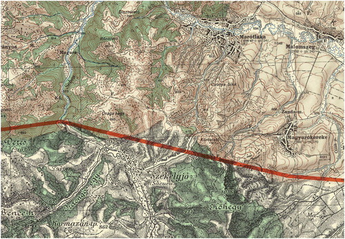
After the political system change, the centralised publication of orienteering maps was discontinued, and clubs and local federations no longer had to ask for permission to make an orienteering map. Orienteers were very interested in finding new areas, especially border areas, which were not allowed for use in the earlier decades. In Sopron the local club extended its orienteering map to the national border, but some other orienteering maps were published later where the national border was the edge of the map. One of the orienteering clubs in the western part of Hungary (Szombathely) was able to organise an orienteering event near the city of Kőszeg in 1994, where the competitors crossed the border during their courses. The small Austrian part of the map was field-worked by Hungarian orienteers, mapmakers. It was a symbolic moment to organise the first cross-border orienteering event at the Austrian border. This section of the Hungarian border was best guarded and strictly controlled during the Cold War era. It was not only fenced, but border barriers (and even mines in the 1950s) were also installed ().
Figure 5. The relevant part of the orienteering map Kőszeg (Király-völgy), 1994 (1:10,000 scale). The NW part of the inset belongs to Austria. Traces of the former border barrier are also visible (a diagonal line parallel to the border section).
Hungary’s joining the Schengen Area has totally changed the situation. Before the implementation of the Schengen Agreement, most borders in Europe were patrolled and a vast network of border posts existed around the continent, to check the identity and entitlement of people wishing to travel from one country to another. The landmark stones are still visible and maintained on the terrain, because these stones are also triangulation points and continuously used for geodetic purposes. The joint border commissions are checking the exact location of the landmarks from time to time.
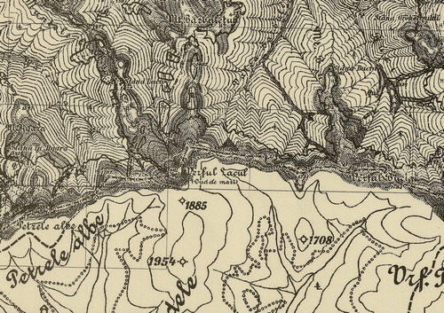
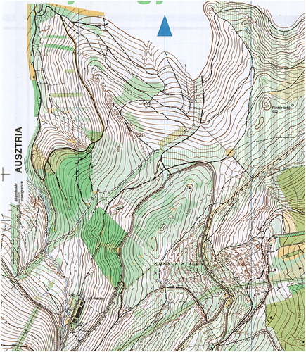
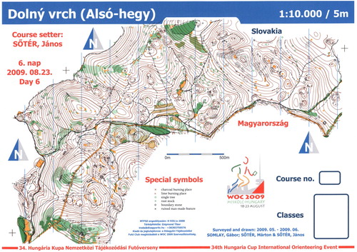
In 2009, Hungary organised the World Orienteering Championships in Miskolc. The long distance race was organised in the very northern part of Hungary, where an unknown karst terrain was used. As the karstland continues in Slovakia, it was seriously taken into consideration that the course would cross the border and the event would be organised in both countries. Finally, due to legal issues, the organisers abandoned the idea. As a multiday public event was also part of the programme to serve the spectators’ need, a cross-border map was used in one of the public events ().
Figure 6. A 2009 orienteering map along the Hungarian–Slovakian border. The thin yellow line is the narrow ride (clearance) of the border.
Not much more than 20–30 years ago, the topographic maps showing state border areas were all classified in the so-called former socialist countries. It is understandable from an emotional point of view that the Czech Republic also published some cross-border orienteering maps (Map portal of ČSOS), but only in the very last years of its existence. An indicative list – without aiming to give an exhaustive list – is below:
Černý les-Szydłówka, 2015: Czech–Polish border, near Karviná.
Mirošovské stěny 3, 2015: Czech–Polish border, north from Meziměstí.
Jáchym Joachymsberg, 2017: Czech–German border, north from Lipová.
Tři díry, 2017: Czech–German border, near Libá.
Pastuszyniec, 2017: Czech–Polish border, north from Karviná.
It is interesting that Slovakia has no such cross-border maps, except the one on the Hungarian–Slovakian border mentioned above. According to our investigation no such cross-border orienteering maps exist in Austria, Romania, Slovenia and Serbia, first of all because this sport is less popular in these countries:
6. Conclusion
Cross-border mapping was always a politically sensitive issue in cartography, especially if a neighbouring country was an enemy. Previously topographic mapping required systematic field working, measurements, but nowadays most of the information that we can use for updating the map content (orthophotos, lidar data, and satellite images) is publicly available.
In orienteering, the fieldwork is always a very time-consuming part of the map production. After establishing the Schengen Area, the cross-border field working became simple and easy, but organising such events may generate legal issues. Therefore, such events and maps are less common than we would think.
Disclosure statement
No potential conflict of interest was reported by the authors.
Notes on contributors
László Zentai is a Full Professor and Head of the Department of Cartography and Geoinformatics at Eötvös Loránd University, Budapest, Hungary. He is the Vice-Rector of the university (he had the same position between 2007 and 2010). Prof. Zentai is the Secretary-General of the International Cartographic Association (2011–2019) and he is serving as the Chairman of the Hungarian National ICA Group. He is a Council member of the International Orienteering Federation. His papers are dealing with computer cartography, cartographic education, topographic mapping, relief representation, orienteering maps, environmental protection and webcartography.
Gábor Gercsák is an Associate Professor of the Department of Cartography and Geoinformatics at Eötvös Loránd University, Budapest, Hungary. He is the Vice-Dean for International Relations of the Faculty of Informatics. His papers are dealing with subjects of cartography, geography and languages. His main interest is the translation and transcription of geographical names. He also publishes on the history of cartography and publishing in Hungary.
ORCID
László Zentai http://orcid.org/0000-0002-6618-6798
Gábor Gercsák http://orcid.org/0000-0003-1289-8228
References
- Balla, J., & Hrenkó, P. (1991). A magyar katonai térképészet története I [History of the Hungarian military mapping]. Budapest: HM Térképész Szolgálat Főnökség.
- Buga, L. (2019). 100 years of Hungarian military mapping, 1919–2019. Budapest: MoD Zrínyi Non-profit Ltd.
- IOF (International Orienteering Federation): International Specification of Orienteering Maps (ISOM). (2019). Retrieved from https://1drv.ms/b/s!As4LDA11gDVmgZIEb6LgOszNwpr3lg
- Jankó, A. (2007). Magyarország katonai felmérései [Military surveys of Hungary]. Budapest: Argumentum-Arcanum.
- Map portal of the Czech Orienteering Federation (ČSOS). Retrieved from https://mapy.orientacnisporty.cz/en/map_browser
- Zentai, L. (2009). The cartographic relief depiction of the Transylvanian sheets of the 1:50,000 scale military survey (1940–1944). In B. Csiki & Z. Bartos-Elekes (Eds.), Descriptio Transylvaniae: International conference on history of cartography and historical geography (pp. 85–93). Cluj-Napoca: Babeş-Bolyai University, Faculty of Geography, Cholnoky Jenő Geographic Society.
- Zentai, L., Buga, L., & Gercsák, G. (2018). Hungarian military mapping abroad 1919–1990. The Cartographic Journal, 55(2), 159–169. doi: 10.1080/00087041.2018.1433768