
ABSTRACT
Gender differences in spatial ability are widely acknowledged, but research to date is equivocal on gender differences in wayfinding ability of children. Indeed, the precise nature of the relationship between gender and wayfinding needs further exploration, especially within real-world outdoor environments. There is a need for more research on this topic, not least to better understand the implications of gender differences in wayfinding for facilitation of our educational programs. This article focuses on this issue by seeking to explore children's map understanding and map use in relation to gender in a large-scale outdoor environment. Ninety-seven children, 3–13 years old, were presented with a pictorial map with 7 controls which they had to locate in any order. Measure of accuracy in wayfinding (number of correctly identified controls) indicate small gender differences. However, measure of efficiency in wayfinding (time spent on the task) indicate that boys outperform girls.
RÉSUMÉ
L'impact de la différence de genre sur les capacités spatiales sont très connues, mais la recherche est aujourd'hui ambiguë sur l'impact du genre sur la capacité des enfants à se diriger. En effet, la nature précise du lien entre le genre et l'orientation n'est pas suffisamment étudiée, en particulier dans le cas de l'environnement extérieur à grande échelle. Il est nécessaire de poursuivre des recherches sur ce sujet, notamment pour mieux comprendre les implications des différences de genre sur l'orientation pour améliorer nos programmes éducatifs. Cet article se concentre sur cette question en cherchant à explorer la compréhension et l'usage de cartes par des enfants en fonction de leur sexe dans un environnement extérieur grande échelle. 97 enfants de 3 à 13 ans ont reçu une carte pictorale contenant 7 points de contrôle qu'ils devaient localiser sur le terrain dans n'importe quel ordre. Les mesures de précision dans l'orientation (le nombre de points correctement identifiés) montrent une petite différence de genre. Toutefois, les mesures d'efficacité de l'orientation (le temps passé sur une tâche) montrent que les garçons sont plus performants que les filles.
1. Introduction
Wayfinding refers to the ability to navigate effectively (Wiegand, Citation2006) and is the purposeful, directed and motivated means for traveling from one point to another. Wayfinding thus involves both movement and decision-making (Golledge, Citation1999; Xia et al., Citation2008). When moving around in A familiar environment, remembering the route and recognizing landmarks on the way are generally enough to get to where you want (Blades, Citation1997; Wiegand, Citation2006). In unfamiliar environments, support is required, and a map is the most important aid (Blades & Spencer, Citation1990; Sigurjónsson, Citation2007).
To be able to use the map for wayfinding in the terrain the map-reader most have the ability to relate the map to the environments it represents, to extract relevant information from the map and apply that information to the actual environment in their navigational map-reading (Blades & Spencer, Citation1990; Lobben, Citation2004). Research indicates that wayfinding involves the use of various cognitive skills (Golledge, Citation1993; Golledge & Stimson, Citation1997; Ottosson, Citation1987a). For example, wayfinding in orienteering tests spatial perception, visualization and spatio-temporal skills as well as memory, concentration and physical ability (Burke et al., Citation2012). Gender has been found to be a significant predictor of wayfinding performance (Coluccia & Louse, Citation2004; Malinowski & Gillespie, Citation2001).
The aim of this article is to expand the understanding of gender differences in children's wayfinding ability. The present study was carried out in a large-scale outdoor environment to shed lights on the gap in research within these settings and involved candidates completing complex tasks, as pinpointed by several researchers (Lawton, Citation1996; Liben et al., Citation2013; Malinowski & Gillespie, Citation2001). Although the present study is aimed at children, we will argue that it is important to assess new findings in this specific field of interest on the basis of gender-differences in a lifelong context. Therefore, we will present a brief overview of the literature on gender-related differences in adults wayfinding before we take a closer look at gender related differences in children's wayfinding. At the end of this section the selection of a pictorial map will be discussed before moving on to describe the particular study that is the focus of this paper.
1.1. Gender differences in adult wayfinding
Gender differences in spatial ability are well established in the literature (Burke et al., Citation2012; Halpern, Citation2004, Citation2012; Linn & Petersen, Citation1985) and research on abstract measures, e.g. paper-and-pencil based assessments of spatial ability, has produced the largest and most consistent gender differences studies (favoring males) in the area of cognition (Halpern, Citation2012; Lawton & Kallai, Citation2002; Liben, Citation2006; Linn & Petersen, Citation1985). Generally, we can say that spatial ability refers to skill in representing, transforming, generating and recalling symbolic, nonlinguistic information (Linn & Petersen, Citation1985), and spatial ability is therefore a required skill in wayfinding.
Findings derived from research on adult wayfinding shows that females have a greater tendency to rely on landmark-based route information and relative direction in their wayfinding strategy. Males, on the other hand, are more likely to rely on global reference points (such as cardinal directions) or the position of the sun, typically reporting better ‘sense-of-direction’ and the use of metric distance information (Choi & Silverman, Citation1996; Dabbs et al., Citation1998; Lawton, Citation1994, Citation1996; Lawton et al., Citation1996; Lawton & Kallai, Citation2002; Wiegand, Citation2006). This suggests that men prefer different types of spatial information and women, and this tendency is also seen in the way men and women give directions to others. Men tend to refer more to the cardinal directions, whereas women refer more often than men to landmarks (Dabbs et al., Citation1998; Lawton, Citation2001; Montello et al., Citation1999). Women also tend to be better at remembering landmarks and their locations (Dabbs et al., Citation1998; Eals & Silverman, Citation1994; Montello et al., Citation1999; Silverman et al., Citation2007; Silverman & Eals, Citation1992). Some studies also show that men tend to be more accurate at indicating the direction of unseen landmarks (Holding & Holding, Citation1989; Lawton, Citation1996; Lawton et al., Citation1996; Lawton & Morrin, Citation1999). These results are mainly derived from research in small-scale or laboratory settings. Malinowski and Gillespie (Citation2001) found that the combination of skills involved in real-world wayfinding may be easier for men, but few studies focuses on whether gender differences in spatial ability found in ‘laboratory settings’ have implications for ‘real world’ behavior (wayfinding) (Burke et al., Citation2012; Choi et al., Citation2006). The link between laboratory tests and performance of wayfinding in the ‘real world’, is a matter of some interest and requires, as several authors have noted, further clarification (Astur et al., Citation1998; Burke et al., Citation2012; Coluccia & Louse, Citation2004; Jones et al., Citation2003; Lawton & Kallai, Citation2002; Montello et al., Citation1999).
1.2. Gender differences in children's wayfinding
Even though gender has been found to be a significant predictor of wayfinding performance among adults (Coluccia & Louse, Citation2004; Malinowski & Gillespie, Citation2001) is it not necessarily so that this directly can be applied to children’s wayfinding (Burke et al., Citation2012; Sigurjónsson, Citation2007; Wiegand, Citation2006). According to Piaget and Inhelder (Citation1956) children's spatial cognitive development takes place through three stages: topological, projective and Euclidean. Topological understanding is the assessment of geographical positions, for example placing different playground equipment in relation to each other. Projective understanding encompasses the ability for spatial orientation and implies that the child understands the spatial relationship between multiple objects at the same time, and can form a conception of reality from a different point of view than his/her own. A child who has reached an Euclidean level will understand that any point in space can be defined in relation to a frame of reference and thus be able to judge accurate distances and angles. For example, based on Euclidean understanding, the child may find the shortest path between two points. Piaget thus believes that children's spatial cognitive development goes through the three stages mentioned, but that projective and Euclidean development can take place in parallel. According to Laurendeau and Pinard (Citation1970), children at approx. 3 years of age solely have a topographic understanding, while projective understanding can be recognized in children between 3 ½ and 5 ½ years, depending on how clear the associated typological signals are. Furthermore, they claim that Euclidean understanding will not be observed in children until the age of 7–10 years. This shows that children's spatial cognitive development can be very different depending on age, and Lawton and Kallai (Citation2002) argue that differences between boys and girls regarding wayfinding have also been found. In a laboratory based design Liben (Citation2006) demonstrated that boys outperform girls on spatial tasks. On the other hand Choi and Silverman (Citation2003) found in a laboratory-based study of route-learning strategies, with 290 children, that gender differences in such strategies did not emerge until 12 years of age. Liben (Citation2006) concludes that there are both studies that suggest that gender-related differences in spatial abilities do not emerge until adolescence, and studies that report gender related differences in spatial abilities for children younger than 12 years of age. Linn and Petersen (Citation1985) suggest, in theirs meta-analysis of gender differences in spatial ability, that male-female differences in spatial ability emerge prior to adolescence, e.g. that gender differences in spatial perception favoring males are first detected around age 7. Furthermore, they suggest that gender differences arise on some types of spatial ability but not others, and that large gender differences are found in measures of mental rotation.Footnote1
From a natural outdoor perspective there are a limited number of studies that illuminate children's spatial ability and map-reading-for-wayfinding (Bjerva & Sigurjónsson, Citation2016; Ottosson, Citation1987b; Sigurjónsson, Citation2007; Wiegand, Citation2006). Webley and Whalley (Citation1987) carried out a study in England, from which they concluded that by age 8, boys had better cognitive mapping ability than girls. Similarly in Norway, Bjerva et al. (Citation2008) found that boys (9 and 10 years old) mastered the skill of aligning a map better than girls of the same age. This skill was examined through giving the children a symbolic plan mapFootnote2 and asking them to align the map in relation to the landscape. Although conducted in an outdoor setting, only a small sample of children (15 boys and 12 girls) was used. A slightly larger outdoor study of 32 preschool children (3–5 ½ years old) in the United States showed a gender difference favoring girls, rather than boys (Stea et al., Citation2004). This study found that girls significantly outperformed boys in locating the target object, but concluded that this had nothing to do with gender differences in spatial skill and probably more to do with a gender difference in complying with the instructions. Sandberg and Huttenlocher (Citation2001) found no gender differences in their study of 19 boys’ and 17 girls’ (aged 5 year, 4 months to 6 year, 11 months) to test the ability to use maps to navigate in a large, enclosed environment.
Research on gender differences within this field is therefore contradictory (Wiegand, Citation2006). Part of the explanation for this inconsistency may be due to how wayfinding performance is measured. It is already argued that differences in the setting (laboratory or ‘real world’) is an important methodological issue, and that this might explain some of the differences in the results and conclusions. Young children solving mapping tasks in small spaces are widely reported in research, but children's performance in large, unfamiliar environments have rarely been tested (Bjerva & Sigurjónsson, Citation2016; Liben et al., Citation2013). Sigurjónsson (Citation2007) also claims that it is important to reflect upon the kind of map used, which varies widely across studies. We will therefore now address the use of different types of maps for children, and why a pictorial map was chosen in this study.
1.3. Pictorial maps
Although mastering symbols is a universal task, it is not an easy one (DeLoache et al., Citation2003). Furthermore, as DeLoache et al. (Citation2003, p. 115) argue ‘The younger the child, the more he or she tends to focus on the concrete object itself, consequently failing to appreciate its abstract relation to what it stands for’, the symbolic map. Young children, especially, seem to find symbolic plan maps ((a)) difficult (Liben & Yekel, Citation1996) and previous research suggests it is easier for children to see an area from an oblique angle, than it is for them to imagine how it will look from above (Downs et al., Citation1988). This is indirectly confirmed by Sigurjónsson (Citation2007) which conclude that children, using a symbolic plan map, display wayfinding behavior which indicates an absoluteFootnote3 conception of the relationship between the map and the ground. However, when using a pictorial map they display wayfinding behavior who indicate a relativisticFootnote4 conception.
Figure 1. The same area shown on three different maps: (a) symbolic plan map (above angle), (b) a pictorial map (above angle) and (c) a pictorial map (oblique angle).
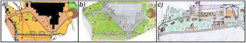
A pictorial map, showing the landscape from an oblique angle ((c)), provides much of the same information that is available from the environment (DeLoache et al., Citation2003), and makes it possible to recognize details without further interpretation. Unlike arbitrary words, symbols used in pictorial maps are iconically motivated in the way that some feature of the symbol matches some feature of the referent, as when blue is used to indicate water (Liben & Yekel, Citation1996). Sigurjónsson (Citation2007) used different types of maps in different contexts, and claims that both young boys and girls can experience serious difficulties in interacting with a symbolic plan map. Therefore a pictorial map ((c)) was chosen for the current study. Even though wayfinding tasks were performed with the help of a pictorial map, the map used was much more complex, in the way that it depicted real-world surroundings and not simple maps of artificial maze surroundings, than most of those used in earlier investigations of children's map-reading (e.g. Blades & Spencer, Citation1985, Citation1986a, Citation1986b, Citation1987a, Citation1987b, Citation1989a, Citation1989b, Citation1994; Bluestein & Acredolo, Citation1979; Presson, Citation1982).
2. Method
This paper presents a study seeking to explore children's wayfinding ability in relation to gender in a real-world outdoor environment. Such ecological approach can be demanding for researchers to carry out (Bryman, Citation2012), but ensures that children's navigational skills can be studied while they practice in the real world. In order to ensure the validity of the study the introduction has highlighted important studies relevant to the research question. This is a platform for this study and at the end a support to the conclusion. In the forthcoming section, we take a closer look at the wayfinding task, the participants in the study and measures of performance.
2.1. The wayfinding task
The intention of the task was to put children's navigational skills to the test. This includes children's ability to form a readiness for movement as well as their physical movement in the environment with continuous spatial updating. The study took place in an unfamiliar environment outdoors. The selected area was a primary school and the nearby surroundings in Norway ((a)), although none of the children who participated in the study were pupils at this school. The map and the information presented in it, together with the landscape features, are important aids in wayfinding. In the design of the wayfinding task, we emphasized both the children's need for a sense of security, and the need for challenges. Due to the age of the children participating (3–13 years old), a pictorial map was judged to be an appropriate tool (DeLoache et al., Citation2003; Downs et al., Citation1988; Liben & Yekel, Citation1996; Sigurjónsson, Citation2007; Stea et al., Citation2004). The map was also judged to give sufficient wayfinding challenges to the oldest children since the whole area that was represented on the map could not be seen from any position (Ottosson, Citation1987a). The size of the map, presented to the children, was 20×30 centimeters covering the selected area of 80×120 meters. The map was hand-drawn based on a photograph taken from a point 30 meters up in the air using a crane car. This was done to ensure that the metric information about distances between the features in the terrain should be in accordance with the metric distances between symbols representing these features in the map.
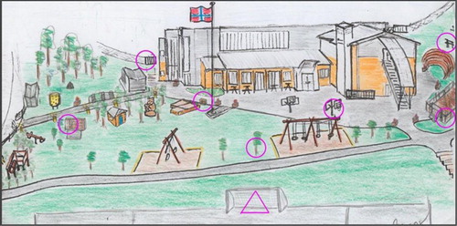
The children were individually taken to a starting point, and were handed the colored pictorial map with seven plotted controlsFootnote5 marked with circles and one starting point marked with a triangle (). The map was given to the children perfectly aligned with the terrain (Ottosson, Citation1987a), when the children stood on the starting point facing the front of the school building. There was nothing said or done regarding alignment beyond that the map was perfectly aligned when the children got it in their hands. Each child was asked; ‘Can you find the places marked with pink circles on your map? You can decide in what order you want to visit them’. Once they had found the first control and punched an electronic chipFootnote6 on the registration unit,Footnote7 they either continued finding the other pink circles straight ahead or needed the task to be repeated to them; ‘Can you find the other places marked with pink circles on your map?’ For the younger children the task had to be repeated more often, but even the youngest children understood what to do and continued the task when it was repeated.
Figure 2. The pictorial map that was used by the children in present study, with seven plotted controls marked with pink circles and one starting point marked with a triangle.
To ensure that the children had understood the task correctly and that they completed the task independently, it was decided to observe the children by ‘shadowing’ them in the terrain (Gerber & Kwan, Citation1994; Ottosson, Citation1987a; Sigurjónsson, Citation2007). Experimental procedures like this are very time-consuming and require recourses and close supervision (Amedeo et al., Citation2009). A group of 46 bachelor students was involved and distributed across four test days so that each child was assigned his/ her own bachelor student (one bachelor student to one child). The bachelor students were graduates with experience in research methodology and were in the process of completing a course in navigation for children (10 ECTS) in their teacher training-program. They were all familiar with and had practiced the method of ‘shadowing’ children while performing navigation earlier. The bachelor students were instructed to act according to the following procedure:
If a child showed signs of uncertainty related to the task, the bachelor students should ask: ‘Do you want me to repeat the task for you?’
If a child was uncertain about how to punch the electronic chip on the registration unit or forgot to do it, the bachelor students should show the child how to do it correctly.
If a child did not show any progress, in relation to the task, the bachelor students were allowed to draw the child's attention to features nearby e.g.; ‘Can you find the school building on your map?’ However, the bachelor students were not allowed to point out features on the children's map or help them in solving the task in any other way.
Each child had an electronic chip and they were told to punch it on the registration unit at the starting point, on each of the seven controls, and finally when they returned to the starting point. The number of controls (7) was anticipated to be at a level so that the children would not become disinterested in the task. It was also important to have a wayfinding task that could be attempted by the whole sample (3–13 years old) so that we could get an indication of how well the children interpreted the map as a wayfinding tool. Based on preliminary studies we gave the children a timeframe of 30 min to complete the task. None of the children reported that they did not have enough time to finish the task, and we conclude that they, who did not find all seven correct controls, did not succeed due to other reasons than the time limit. These reasons could e.g. be lack of skills.
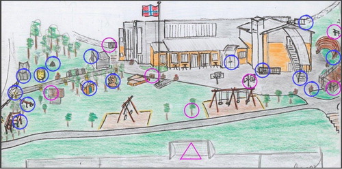
The children were instructed to practice navigational map-reading to locate 7 specific features in the landscape. To ensure they did not run around randomly seeking for white and orange flags, and actually used the map actively in their wayfinding, there were 22 controls placed in the environment. Of these, only seven were marked on the children's map for them to locate (). All 22 controls were thus marked with white and orange flags and units for registration, but had no visible identifying code numbers. Visible identifying-codes could divert the children's focus from the map reading, and lead them instead to seek out the controls and check which controls have the correct identifying-codes, i.e. find correct controls by trial and error. Children could punch the registration units at any of the 22 controls, but were instructed to locate and punch the electronic chip only on the controls according to their map and then return to the starting point. If the children had been allowed to punch on all the 22 controls, they would have registrations from all the seven correct controls, regardless of their map reading ability. Each child was therefore, only allowed to punch the electronic chip on seven controls. Bachelor students were on hand at all times to keep track of the number of controls each child had found and the number of controls that remained, so that in the end every child had seven punches in their electronic chip. Mistakes in this specific test, are therefore defined when children punching on any of the controls marked with blue circles (finding a wrong control) instead of punching on controls marked with pink circles (finding the correct control).
Figure 3. The pictorial map showing the start point marked with a triangle and the 22 controls that was marked with white and orange flags and units for registration in the area. The pink circles are the 7 controls that were marked on the children's maps and for them to find. The 15 blue circles were only marked in the terrain, but not on the children's map.
2.2. Participants
The age composition, which Ottosson (Citation1987a) and Sigurjónsson (Citation2007) used in their map-reading and wayfinding studies, formed the basis for including children from different educational levels in the sample. To ensure a sufficiently large percentage of children of different ages, a systematic sampling was conducted. The participants were drawn from a pool comprising three different kindergartens and one primary school (N = 429, 236 boys and 193 girls). From this population a sample of 106 children (53 boys and 53 girls) were selected through stratified systematic sampling (Bryman, Citation2012).
The children in kindergartens in Norway are divided into groups (10–20 children of both sexes), based on age. One group from each of the three kindergartens were randomly selected, and these groups contained only children who were older than 3 years of age (n = 45) as it was considered inappropriate to bring children below three years of age into the sample (Blades & Spencer, Citation1985; Blades & Spencer, Citation1987a, Citation1987b; Bluestein & Acredolo, Citation1979; Stea et al., Citation2004). In primary school, pupils are divided into grades 1–7, based on age. In grade 1 the pupils are 5–6 years old and in grade 7 the pupils are 12–13 years old. Each grade is again divided into smaller groups containing from 15 to 30 children of both sexes. The population was therefore already stratified into groups and each group was included on a list with a specific number. Like the children in kindergarten, groups were selected to be included in the sample and not individual children. To ensure a sufficiently large percentage of children of different ages in the sample, systematic sampling was conducted. A random start between the groups in grade 1 and grade 2 was made, and thereafter every fourth group on the list was selected. The final sample included children from kindergarten and grade 1, 3, 5 and 7 in primary school. Children tend to get sick now and then and therefore the final sample comprised those children selected who actually attended kindergarten and school on the specific test day (n = 97, 49 boys and 48 girls).
The sample was divided into three age groups relating to their stage of schooling (), and each of these three age groups contained both boys and girls. Group A refers to children in kindergarten aged 3–5 years old. Age distribution in the sample was 7 children age 3 years, 17 children age 4 years and 17 children aged 5 years. Group B refers to children in lower primary stage aged 5–9 years old. Age distribution in this group was 15 pupils from grade 1 and 14 pupils from grade 3. Group C refers to children in upper primary stage aged 9–13 years old. Age distribution in this group was 15 pupils from grade 5 and 12 pupils from grade 7.
Table 1. Description of the sample of children selected for inclusion in the study.
Each group can be considered as relatively small, but no groups were too small for statistical analysis. Nevertheless, one should keep this fact in mind when making statistical calculations.
2.3. Measures
The aim was to measure how boys and girls of different ages perform in a wayfinding task. Large-scale spatial abilities were measured on the appropriate scale in an outdoor setting, in terms of accuracy and efficiency. To identify any gender differences in relation to how children interact with pictorial maps, the comparisons were made in relation to the following measures of performance:
Average number of correct controls found.
The percentage of children who completed the task successfully (found all 7 controls).
Average time spent on the task (for those who found all 7 controls).
3. Findings
The data relates to 97 Norwegian children, 49 boys and 48 girls. The further results are presented in terms of overall results (), the average number of correct controls found (), percentage of children who found all 7 controls () and the average time spent finding all 7 controls (). Age and gender are independent variables.
Table 2. Overall results divided into groups and gender.
Table 3. Average number of correct controls found (maximum score is 7 controls).
Table 4. Percentage of children who completed the task successfully (found all 7 controls).
Table 5. Average time (in seconds) spent on the task for children who completed the task successfully (found all 7 controls).
The results shows statistically significant differences between the three groups regarding both average number of correct controls found, percentage of children who found all 7 controls and the average time spent finding all 7 controls. Furthermore, the results show that there are no statistically significant differences between boys and girls regarding average number of correct controls found and percentage of children who found all 7 controls, but the boys spent less average time finding all 7 controls compared with the girls (statistically significant, p < 0.05).
The results show small differences between boys and girls regarding the average number of correct controls found. None of the differences between boys and girls in any of the three groups (A, B or C) was statistically significant. In relation to age however, the differences between the children in the three groups were statistically significant for girls in group A vs. group B (p < 0.01) and for boys in group B vs. group C (p < 0.10).
There were no statistically significant differences between boys and girls within each group regarding the percentage of children who found all 7 controls. The number of both boys and girls who found all 7 controls increases by age. The difference from group A to B was statistically significant (p < 0.05) for girls, but not statistically significant for boys. The difference from group B to C is smaller and only statistically significant (p < 0.10) for the boys.
The boys in group A use on average significantly (p < 0.05) less time to find all 7 controls than the girls in the same group. We can also find this tendency in group B and C, but the results are not statistically significant. Both boys and girls reduce the time spent to find all 7 controls by age. These results are statistically significant from group A to B and from group B to C for both boys and girls.
4. Discussion
There is a broad consensus that adult males generally perform better than adult females on tasks requiring spatial ability (Burke et al., Citation2012; Coluccia & Louse, Citation2004; Malinowski & Gillespie, Citation2001). The greater part of this research was derived from research in laboratory-based settings. Findings from research on adults in real-world settings also suggests that men and women prefer different types of spatial information and use different strategies in their wayfinding (Malinowski, Citation2001; Malinowski & Gillespie, Citation2001; Montello et al., Citation1999). Whether or not there are gender differences in children's wayfinding, and when differences may occur, is not that clear. Research on gender differences in children's wayfinding are contradictory (Wiegand, Citation2006), and in this study, we therefore wanted to challenge children's capability to understand and use a pictorial map in a large-scale outdoor setting, to reveal any gender differences in their wayfinding ability.
The overall results in this study indicate that understanding and using map is an ability that progresses in complexity from kindergarten to upper primary stage, and both boys and girls perform significantly better on all the three different measurements when age increases (). This progress, in relation to age, is consistent with theories of development in general (e.g. Piaget et al., Citation1960; Piaget & Inhelder, Citation1956) and with research on spatial ability and wayfinding specifically for example Liben, Citation2009; Liben & Yekel, Citation1996; Linn & Petersen, Citation1985; Quinn & Liben, Citation2008. The path to map understanding is a slow and complex one, and is a gradual and protracted process (Blades & Spencer, Citation1994; Liben & Downs, Citation1989; Liben & Yekel, Citation1996; Uttal, Citation1996). At the most general level, the data from present study are consistent with this position. The process of locating the correct controls in the terrain is one who shows the map-readers ability to understand and use map, to transform the information in the map to appropriate movement in the terrain so they can locate the correct controls. In that way, the findings indicate that children in kindergarten show understanding of the relation between locations in the referent space and map, but that this is an understanding that is under way and gradually developing.
Furthermore, the overall results regarding gender shows no differences related to the average number of correct controls found or the percentage of children, who found all 7 controls, but the boys solve the task significantly faster than the girls (). At all age levels, boys will have a better endurance than girls will, but before the age of 10–12, the differences are relatively small. The girls ‘maximum aerobic endurance accounts for 85–90% of the boys’ aerobic endurance (Malina et al., Citation2004). It is therefore natural to assume that physical differences cannot explain these results alone.
The results (i.e. the average number of correct controls found and the percentage of children, who found all 7 controls) can thus give the impression that there are no gender differences in children's wayfinding ( and ). This is in contrast to the part of the research, which report gender differences within spatial ability. Linn and Petersen (Citation1985) showed in their meta-analysis that there are gender differences. Some emerge early in life as for mental rotation (Linn & Petersen, Citation1985; Quinn & Liben, Citation2008), and some occur in childhood and accelerate beyond adolescence, as for spatial perception (Linn & Petersen, Citation1985). Linn and Petersen (Citation1985) suggest that spatial perception is easier for males than females, but that gender differences in spatial ability are large only for mental rotation. In accordance with our findings, Burke et al. (Citation2012) claims that when physical differences are accounted for, men and women with equivalent experience performed equally well at complex navigation tasks in an outdoor setting. The study of Burke et al. is based on adults, and as we have argued in the introduction, it is not clear that the results will be the same in terms of children. Even though Choi and Silverman (Citation2003) found that gender, differences did not emerge until a later stage of age, Liben (Citation2006) states that there are studies that suggest that gender-related differences both emerged in childhood and in adolescence. Our results can be interpreted as the fact that boys and girls understand and use the map in a large-scale outdoor wayfinding setting equally well, but it is difficult to conclude when previous research is so inconsistent regarding this.
Despite the fact that we do not find significant gender differences in average number of correct controls found or the percentage of children, who found all 7 controls, there are significantly differences in average time spent on the task for children who completed the task successfully (). A reasonable assumption would be that the more expert the child is as a map-reader, the faster he or she will complete a wayfinding task. In the youngest group of children who found all 7 controls, boys outperform girls regarding average time spent on the task. This tendency can also be seen in the other two groups, but are only statistically significant in group A. Malinowski and Gillespie (Citation2001) and Astur et al. (Citation1998) found that men were faster than women at locating a target, and our results indicates that this might be the case also for children. It may therefore seem that girls and boys carried out the wayfinding task equally well, but that boys, especially the youngest ones, solved the task significantly faster than the girls did. These findings support Linn and Petersen’s (Citation1985) study who found that gender differences occur in some aspects of wayfinding, but not in others.
A large age range in the sample (3–13 years) is challenging in terms of the design of the task. It is natural to worry about whether the task is experienced as too difficult for the youngest children and too easy for the oldest pupils, and that this will influence the results. At the most general level, the data from the present study shows that a large proportion of the children, even among the youngest, master the use of a pictorial map in the wayfinding task. It is important to notice, that children in kindergarten, with this tool, do show important/skilled understanding of the relation between locations in the referent space and map. This confirms our impression that a pictorial map is an appropriate tool, and is experienced as an aid, not a constraining factor for the completion of the task, even for the youngest children in the sample (DeLoache et al., Citation2003; Liben & Yekel, Citation1996; Ottosson, Citation1987a; Sigurjónsson, Citation2007). On the other hand, the data may give the impression that the wayfinding task was too easy for the older children. We will argue that when the speed is raised the possibility of errors (punching the chip on wrong registration unit) increases. Higher speed including continuous change of direction will challenges the map-readers (the child's) ability to keep the map aligned, something which provides a better basis for keeping steady direction towards the control, and a better context in order to perceive the present task correctly (Sigurjónsson, Citation2007). One has also to keep in mind that there were 15 incorrect controls in the area (), which represents opportunities for mistakes, especially when the speed is increased. Such a setting may be comparable to what happens in orienteering contests in park areas. The area itself can be experienced as easy, but when the speed is increases (as is the case in present study) relatively simple tasks can be experienced as difficult because the competitors (or child) must make important navigational decisions quickly. This is important to bear in mind in relation to what is measured, and we would belief that this extends the significance of our research. It is also interesting to notice that previous research (Sigurjónsson, Citation2007) shows that novices often keep the south of the map into the body, irrespective of the direction of movement, and that this relationship creates confusion in their map reading. If this occurs, then one must use mental rotation to make maps and terrain match. According to previous research (Linn & Petersen, Citation1985) which shows that males outperform females on mental rotation at any age this can be one of the reasons why boys outperform girls in our study.
Interesting questions are whether individual differences between boys and girls are biologically and/or environmentally conditioned and whether boys have developed different navigational strategies than girls (as previous reports suggest is the case with adults) (Dabbs et al., Citation1998; Wiegand, Citation2006). Our findings indicate that gender differences in some types of spatial ability might emerge even before the age of 12, as some researchers claim it does not (Choi & Silverman, Citation2003). Furthermore, research suggests that men and women prefer different types of spatial information (Choi & Silverman, Citation2003; Dabbs et al., Citation1998; Lawton, Citation1996; Lawton et al., Citation1996; Lawton & Kallai, Citation2002; Wiegand, Citation2006). If this is the case, it seems that young girls tend to rely on landmark-based route information, which is more time consuming than the strategies boys tend to rely on, but our data do not give any clear indication about whether this is the case.
5. Conclusion
The objective of the present study was to identify any tendencies regarding gender-related differences in children using a pictorial map in a large-scale outdoor environment. In conclusion, gender-related differences, or absence of, are now more specifically described. Our findings indicate that there are very small or no differences in how boys and girls are carrying out a wayfinding task, measured by the average number of correct controls found and number of children who completed the task. Furthermore, the findings show a tendency for boys to solve the wayfinding task significantly faster than the girls do. Both boys and girls perform significantly better in relation to age and this development was equally strong in both gender. The present results are both consistent and inconsistent with previous research, and further investigation will be important in the future, not least in order to better understand educational consequences of any gender differences in children's wayfinding in large-scale settings. In view of the importance of spatial ability in many scientific domains, educational intervention should start early to provide relevant experience, and to prevent larger gender differences than necessary from emerging (Tzuriel & Egozi, Citation2010).
Choosing the appropriate map for the wayfinding task is important and can in various ways effect the result of the performance. ‘Indeed, a significant effect of map form was evident: Children performed better on the oblique than the plan map’ (Liben & Yekel, Citation1996, p. 2794). Our findings suggest that an oblique pictorial map would be a good way of introducing wayfinding for children even at an early age. It may also seem as if a pictorial map can be used equally well by both boys and girls to challenge and develop their spatial abilities and improve their map understanding and map use.
Acknowledgements
The authors express their sincere thanks to Professor Gudbrand Lien for his help with the statistical analyzing of the data; Professor Miranda Thurston for insightful comments on earlier versions on this manuscript; and the participating children for their time and enthusiasm. This research received no specific grant from any funding agency, commercial or not-for-profit sectors.
Disclosure statement
No potential conflict of interest was reported by the author(s).
Notes on contributors
Thorsteinn Sigurjónsson, an Associate Professor of Sport and Physical Education, writes on children and navigational wayfinding, sport and mathematics education in the early years. His recent article is “Wayfinding by Means of Maps in Real-world Settings: A Critical Review” (Journal of Navigation, 2016) and recent book are “Sport in Scandinavia and the Nordic countries” (Routledge, 2019), and book chapter “Young Children's Cross-Domain Mapping of Numerosity in Path Navigation” (Springer, 2020).
Trine Bjerva, a Senior Lecturer of Sport and Physical Education, writes on children and navigational wayfinding. Her recent article is “Wayfinding by Means of Maps in Real-world Settings: A Critical Review” (Journal of Navigation, 2016).
Jon Anders Græsli, a Senior Lecturer of Sport and Physical Education, writes on children and navigational wayfinding. The latest article is “Children's communication with different types of map - a progressive approach to map-reading” (Acta Didactica, 2011).
Notes
1 The ability to rotate a two or three dimensional figure rapidly and accurately (Shepard & Cooper, Citation1982).
2 A symbolic plan map is an artificial construction on which an interpretation can be performed, but only by understanding or accepting the conventions, which underlie it. Landmarks, for example a stone, are reproduced as symbols on the map, and a prerequisite for interpreting these symbols is to understand that the same symbol can represent only one type of landmark (Keates, Citation1996).
3 Perceives that the map conveys a sequential message that can be easily decoded and the task is conceived of as directly (absolutely) defined on the map. Then the task can be done in a particular order almost regardless of where it is performed (Ottosson, Citation1987a).
4 Understands that the identity or the features on the map depend upon their relative positions (Ottosson, Citation1987a).
5 Points in the environment that must be located is known as ’controls’ (Eccles et al., Citation2002). A control is marked on a map with a circle around the specific point, and the specific point shall be exactly centered in the middle of the circle. In the terrain, a control is marked with a white and orange flag. The flag should be easily visible and not hidden away.
6 In the study we used Emit, which is mainly used as electronic timing system in Norway. The registration units (e-Post) was placed on the start/finish, and in addition on every control (see Emit hompage http://emit.no/en/product/ver5-e-card-389).
7 Each child had an electronic chip (e-Card) to record time and place. See Emit homepage http://emit.no/en/product/epost-380.
References
- Amedeo, D., Golledge, R. G., & Stimson, R. J. (2009). Person-environment-behavior research: Investigating activities in spaces and environments. The Guilford Press.
- Astur, R. S., Ortiz, M. L., & Sutherland, R. J. (1998). A characterization of performance by men and women in a virtual Morris water task: A large and reliable sex difference. Behavioural Brain Research, 93(1–2), 185–190. https://doi.org/10.1016/S0166-4328(98)00019-9
- Bjerva, T., & Sigurjónsson, T. (2016). Wayfinding by means of maps in real-world settings: A Critical Review. Journal of Navigation, 1–13, 70(2), 263–275. https://doi.org/10.1017/S0373463316000643
- Bjerva, T., Solbakken, T., & Sigurjónsson, T. (2008). Spiller det noen rolle hvor barn lærer? - orientering som eksempel [Does it matter where children learn? – Orienteering as example]. Nordisk Pedagogik, 28(1), 63–71.
- Blades, M. (1997). Research paradigms and methodologies for investigating children’s wayfinding. In N. Foreman & R. Gillett (Eds.), Handbook of spatial research Paradigms and Methodoligies. Volume 1: Spatial cognition in the child and adult (pp. 103–129). Psychology Press.
- Blades, M., & Spencer, C. (1985). Using maps. Child Education, 26–27.
- Blades, M., & Spencer, C. (1986a). Map use in the environment and educating children to use maps. Environmental Ecucation and Information, 5, 187–204.
- Blades, M., & Spencer, C. (1986b). Maps and wayfinding. Man, New Series, 21(2), 342–346.
- Blades, M., & Spencer, C. (1987a). The use of maps by 4-6 year old children in a large-scale maze. British Journal of Developmental Psychology, 5(1), 19–24. https://doi.org/10.1111/j.2044-835X.1987.tb01037.x
- Blades, M., & Spencer, C. (1987b). Young children’s strategies when using maps with landmarks. Journal of Environmental Psychology, 7(3), 201–217. https://doi.org/10.1016/S0272-4944(87)80030-0
- Blades, M., & Spencer, C. (1989a). Children’s wayfinding and mapusing abilites. Scientific Journal of Orienteering, 5, 48–60.
- Blades, M., & Spencer, C. (1989b). Young childrens ability to use coordinate references. Journal of Genetic Psychology, 150, 5–18. https://doi.org/10.1080/00221325.1989.9914570
- Blades, M., & Spencer, C. (1990). The development of 3- to 6-year-Olds’ Map using ability: The relative importance of landmarks and map alignment. Journal of Genetic Psychology, 151(2), 181–194. https://doi.org/10.1080/00221325.1990.9914653
- Blades, M., & Spencer, C. (1994). The development of children’s ability to use spatial representation. Advances in Child Development and Behavior, 25, 157–199. https://doi.org/10.1016/S0065-2407(08)60052-X
- Bluestein, N., & Acredolo, L. (1979). Developmental changes in map-reading skills. Child Development, 50(3), 691–697. https://doi.org/10.2307/1128934
- Bryman, A. (2012). Social research methods (4th ed. utg.). Oxford University Press.
- Burke, A., Kandler, A., & Good, D. (2012). Women who know their place. Human Nature, 23(2), 133–148. https://doi.org/10.1007/s12110-012-9140-1
- Choi, J., McKillop, E., Ward, M., & L’Hirondelle, N. (2006). Sex-specific relationships between route-learning strategies and abilities in a large-scale environment. Environment and Behavior, 38(6), 791–801. https://doi.org/10.1177/0013916506287004
- Choi, J., & Silverman, I. (1996). Sexual dimorphism in spatial behaviors: Applications to route learning. Evolution and Cognition, 2(2), 165–171.
- Choi, J., & Silverman, I. (2003). Processes underlying sex differences in route-learning strategies in children and adolescents. Personality and Individual Differences, 34(7), 1153–1166. https://doi.org/10.1016/S0191-8869(02)00105-8
- Coluccia, E., & Louse, G. (2004). Gender differences in spatial orientation: A review. Journal of Environmental Psychology, 24(3), 329–340. https://doi.org/10.1016/j.jenvp.2004.08.006
- Dabbs, J. M., Chang, E. L., Strong, R. A., & Milun, R. (1998). Spatial ability, navigation strategy, and geographic knowledge among men and women. Evolution and Human Behavior, 19(2), 89–98. https://doi.org/10.1016/S1090-5138(97)00107-4
- DeLoache, J. S., Pierroutsakos, S. L., & Uttal, D. H. (2003). The origins of pictorial competence. Current Directions in Psychological Science, 12(4), 114–118. https://doi.org/10.1111/1467-8721.01244
- Downs, R., Liben, L. S., & Daggs, D. (1988). On education and geographers: The role of cognitive developmental theory in geographic education. Annals of the Association of American Geographers, 78(4), 680–700. https://doi.org/10.1111/j.1467-8306.1988.tb00238.x
- Eals, M., & Silverman, I. (1994). The Hunter-Gatherer theory of spatial sex differences: Proximate factors mediating the female advantage in recall of object arrays. Ethology and Sociobiology, 15(2), 95–105. https://doi.org/10.1016/0162-3095(94)90020-5
- Eccles, D. W., Walsh, S. E., & Ingledew, D. K. (2002). The use of heuristics during route planning by expert and novice orienteers. Journal of Sports Sciences, 20(4), 327–337. https://doi.org/10.1080/026404102753576107
- Gerber, R., & Kwan, T. (1994). A phenomenographical approach to the study of pre-adolescents’ use of maps in a wayfinding exercise in a suburban environment. Journal of Environmental Psychology, 14(4), 265–280. https://doi.org/10.1016/S0272-4944(05)80218-X
- Golledge, R. G. (1993). Geography and the Disabled: A Survey with Special reference to Vision Impaired and Blind Populations. Transactions of the Institute of British Geographers, 18(1), 63–85. https://doi.org/10.2307/623069
- Golledge, R. G. (1999). Wayfinding behavior: Cognitive mapping and other spatial processes. Johns Hopkins University Press.
- Golledge, R. G., & Stimson, R. J. (1997). Spatial behavior: A geographic perspective. Guilford Press.
- Halpern, D. F. (2004). A cognitive-process taxonomy for sex differences in cognitive abilities. Current Directions in Psychological Science, 13(4), 135–139. https://doi.org/10.1111/j.0963-7214.2004.00292.x
- Halpern, D. F. (2012). Sex differences in cognitive abilities. Psychology Press.
- Holding, C. S., & Holding, D. H. (1989). Acquisition of route network knowledge by males and females. Journal of General Psychology, 116(1), 29–41. https://doi.org/10.1080/00221309.1989.9711108
- Jones, C. M., Braithwaite, V. A., & Healy, S. D. (2003). The evolution of sex differences in spatial ability. Behavioral Neuroscience, 117(3), 403–411. https://doi.org/10.1037/0735-7044.117.3.403
- Keates, J. S. (1996). Understanding maps (2nd ed.). Longman.
- Laurendeau, M., & Pinard, A. (1970). The development of the concept of space in the child. International Universities Press.
- Lawton, C. A. (1994). Gender differences in way-finding strategies: Relationship to spatial ability and spatial anxiety. Sex Roles, 30(11-12), 765–779. https://doi.org/10.1007/BF01544230
- Lawton, C. A. (1996). Strategies for indoor wayfinding: The role of orientation. Journal of Environmental Psychology, 16(2), 137–145. https://doi.org/10.1006/jevp.1996.0011
- Lawton, C. A. (2001). Gender and regional differences in spatial referents used in direction giving. Sex Roles, 44(5–6), 321–337. https://doi.org/10.1023/A:1010981616842
- Lawton, C. A., Charleston, S. I., & Zieles, A. S. (1996). Individual- and gender-related differences in Indoor wayfinding. Environment and Behavior, 28(2), 204–219. https://doi.org/10.1177/0013916596282003
- Lawton, C. A., & Kallai, J. (2002). Gender differences in wayfinding strategies and anxiety about wayfinding: A cross-cultural comparison. Sex Roles 47, 389–401. https://doi.org/10.1023/A:1021668724970
- Lawton, C. A., & Morrin, K. A. (1999). Gender differences in pointing accuracy in computer-simulated 3D mazes. Sex Roles, 40(1-2), 73–92. https://doi.org/10.1023/A:1018830401088
- Liben, L. S. (2006). Education for spatial thinking. In W. Damon, & Richard M. Lerner. (Series Eds.) and K. A. Renninger, & I. E. Sigel (Vol. Eds.), Handbook of child psychology. 6th ed. (Vol. 4, pp. 197–204). Wiley.
- Liben, L. S. (2009). The road to understanding maps. Current Directions in Psychological Science, 18(6), 310–315. https://doi.org/10.1111/j.1467-8721.2009.01658.x
- Liben, L. S., & Downs, R. (1989). Understanding maps as symbols: The development of map concepts. in children. In I. H. W. Reese (Ed.), Advances in child delvelopment and behavior (Vol. 22, pp. 145–201). Academic Press.
- Liben, L. S., Myers, L. J., Christensen, A. E., & Bower, C. A. (2013). Environmental-scale map use in middle childhood: Links to spatial skills, strategies, and gender. Child Development, 84(6), 2047–2063. https://doi.org/10.1111/cdev.12090
- Liben, L. S., & Yekel, C. A. (1996). Preschoolers’ understanding of plan and oblique maps: The role of geometric and representational correspondence. Child Development, 67(6), 2780–2796. https://doi.org/10.2307/1131752
- Linn, M. C., & Petersen, A. C. (1985). Emergence and characterization of sex differences in spatial ability: A meta-analysis. Child Development, 56(6), 1479–1498. https://doi.org/10.2307/1130467
- Lobben, A. K. (2004). Task, strategies, and cognitive processes associated with navigational map reading: A review perspective. The Professional Geographer, 56(2), 2, 270–281. https://doi.org/10.1111/j.0033-0124.2004.05602010.x
- Malina, R. M., Bouchard, C., & Bar-Or, O. (2004). Growth, maturation and physical activity. Human Kinetics.
- Malinowski, J. C. (2001). Mental rotation and real-world wayfinding. Perceptual and Motor Skills, 92(1), 19–30. https://doi.org/10.2466/pms.2001.92.1.19
- Malinowski, J. C., & Gillespie, W. T. (2001). Individual differences in performance on a large-scale, real-world wayfinding task. Journal of Environmental Psychology, 21(1), 73–82. https://doi.org/10.1006/jevp.2000.0183
- Montello, D. R., Lovelace, K. L., Golledge, R. G., & Self, C. M. (1999). Sex-related differences and similarities in geographic and environmental spatial abilities. Annals of the Association of American Geographers, 89(3), 515–534. https://doi.org/10.1111/0004-5608.00160
- Ottosson, T. (1987a). Map-reading and wayfinding. Gothenburg University.
- Ottosson, T. (1987b). The world in mind: Mental models of spatial relations (Vol. 1987:01).
- Piaget, J., & Inhelder, B. (1956). The child’s conception of space. Routledge & Kegan Paul.
- Piaget, J., Inhelder, B., & Szeminska, A. (1960). The child’s conception of geometry. Routledge and Kegan Paul.
- Presson, C. C. (1982). The development of Map-reading skills. Child Development, 53(1), 196–199. https://doi.org/10.2307/1129653
- Quinn, P. C., & Liben, L. S. (2008). A sex difference in mental rotation in young infants. Psychological Science, 19(11), 1067–1070. https://doi.org/10.1111/j.1467-9280.2008.02201.x
- Sandberg, E. H., & Huttenlocher, J. (2001). Advanced spatial skills and advance planning: Components of 6-year-old’s navigational map use. Journal of Cognition and Development, 2(1), 51–70. https://doi.org/10.1207/S15327647JCD0201_3
- Shepard, R. N., & Cooper, L. A. (1982). Mental images and their transformations. Massachusetts Institute of Technolo.
- Sigurjónsson, T. (2007). Barns kartlesing: Et samspill mellom kartleser, kart og terreng [Children’s map reading: An interaction between map-reader, map and terrain]. Norwegian School of Sport Sciences.
- Silverman, I., Choi, J., & Peters, M. (2007). The Hunter-Gatherer theory of sex differences in spatial abilities: Data from 40 countries. Archives of Sexual Behavior, 36(2), 261–268. https://doi.org/10.1007/s10508-006-9168-6
- Silverman, I., & Eals, M. (1992). Sex differences in spatial abilities: Evolutionary theory and data. In I. J. H. Barkow, L. Cosmides, & J. Tooby (Red.), The adapted mind: Evolutionary psychology and the generation of culture (s. 533–549). Oxford University Press.
- Stea, D., Kerkman, D. D., Piñon, M. F., Middlebrook, N. N., & Rice, J. L. (2004). Preschoolers use maps to find a hidden object outdoors. Journal of Environmental Psychology, 24(3), 341–345. https://doi.org/10.1016/j.jenvp.2004.05.003
- Tzuriel, D., & Egozi, G. (2010). Gender differences in spatial ability of young children: The effects of training and processing strategies. Child Development, 81(5), 1417–1430. https://doi.org/10.1111/j.1467-8624.2010.01482.x
- Uttal, D. H. (1996). Angles and distances: Children’s and adult’s reconstruction and scaling of spatial configurations. Child Development, 67(6), 2763–2779. https://doi.org/10.2307/1131751
- Venables, W., & Smith, D. (2009). R development Core Team. An introduction to R—notes on R: A programming environment for data analysis and graphics, version 2.8. 0. Network Theory.
- Webley, P., & Whalley, A. (1987). Sex differences in children’s environmental cognition. The Journal of Social Psychology, 127(2), 223–225. https://doi.org/10.1080/00224545.1987.9713685
- Wiegand, P. (2006). Learning and teaching with maps. Routledge.
- Xia, J., Arrowsmith, C., Jackson, M., & Cartwright, W. (2008). The wayfinding process relationships between decision-making and landmark utility. Tourism Management, 29(3), 445–457. doi: 10.1016/j.tourman.2007.05.010