
ABSTRACT
In the context of assertions that defining a map is an illogical and futile exercise, this paper examines the distinctiveness of the discipline of cartography and the success of the human endeavour that has produced ‘things’ called maps. We contend not only that cartography is a coherent and distinctive discipline (although we do consider the semantics involved in, and rationale for, referring to it by that name), but that human society cannot function without maps. The major reason for this is that each map is created for a human or societal purpose – and this purpose defines the nature and utility of the map. The role of a map defines the very nature of a map itself, and we reflect on the creation, functionality, and success of mapping activity. This leads us to conclude with pointers to functional definition of the map.
ABSTRACTO
Dans le contexte d'assertions affirmant que définir une carte est un exercice illogique et futile, cet article examine le caractère distinctif de la cartographie en tant que discipline et le succès de l'effort humain qui a produit des « choses » que l'on nomme des cartes. Nous proclamons non seulement que la cartographie est une discipline cohérente et à part entière (bien que nous considérions la sémantique impliquée et sa justification en s'y référant par ce nom), mais également que la société humaine ne peut pas fonctionner sans cartes. La raison principale est que chaque carte est créée dans un but humain ou sociétal – et ce but définit la nature et l'utilité de la carte. Le rôle d'une carte définit la nature même de cette carte, et nous réfléchissons à la création, la fonctionnalité et le succès de l'activité cartographique. Cela nous permet de conclure en donnant des indications sur une définition fonctionnelle de la carte.
1. Assessing the nature of a discipline
The study of human knowledge, methods of acquiring and testing it, the distinguishing of knowledge from belief, and the definition of the scope of knowledge, all form the study of epistemology. It attempts to be judgement- and value-free, as such human opinion is often contrasted with the certitude of knowledge. In that sense, knowledge is normative and prescriptive (Schroeder, Citation2015), and this ‘rational’ approach is most obviously manifest in contemporary scientific enquiry and investigation. In the earlier Western tradition (for example, in ancient Greece), a broad approach using conjoined methods, such as mathematics, philosophical reflection, and cosmographical observation, was used to identify universal knowledge and meaning. Such knowledge was expected to lead to understanding and wisdom, and subsequently coherent and cogent organisation of human society and behaviour. Today, the primary way in which similar investigations and practices are undertaken is under disciplinary headings. This paper attempts to consider the nature of cartography as a discipline; to identify its primary focus, the map, as an item; and to elucidate the map as essential in human society.
The identification and development of ‘disciplines’ as frameworks within which human society and endeavour adapts, consolidates, progresses and reflects is not long-established. The categorisation of methods of pursuing knowledge became necessary when the extent of scientific enquiry became overwhelmingly broad. But the naming of ‘physics’ (late sixteenth century), ‘chemistry’ (late eighteenth century), ‘biology’ (early nineteenth century) in English and contemporaneously in most other spoken languages is recent. ‘Cartography’ was not adopted as a regular term until the mid-nineteenth century. Using such discrete and compartmentalised terms to describe and instigate human investigation and practice inevitably reflects the society and societal structures within which, and the individuals by which, such discipline names have been devised. Thus, a criticism of the term ‘cartography’ is that it has been initially formulated in a western scientific tradition, and appears to ignore activity that can be regarded as ‘cartographic’, but which does not fit the standardised ideal (the perceived ideal embodies a flowline of tasks similar to: (i) observation of reality =>(ii) impartial and accurate transformation of spatial data =>(iii) graphical illustration of scaled image =>(iv) map reproduction).
On the other hand, any focus on identifying disciplines (and not only scientific disciplines) does require the determination of the unique characteristics (that could be called an ideal) which acceptably, to human observers, commentators, and society, define its core of study and practice. Each discipline has boundaries, to assist in defining what is, and what is not, part of the scope of the discipline. For some, the establishment of distinct and defined subject matter within a discipline can be regarded as beneficial. Professions, such as engineering and law, regard knowledge of their subject matter to be fundamental to a human’s ability to effectively contribute to society in these fields. Thus qualifications, registration, and continuing education and development are required to practice such activities within society. In some cases, the requirement for mastery of the specified range of a discipline is mandated by government or other public interest body for a number of reasons – for public safety (e.g. mariners and pilots), for effective economic management (e.g. accountants), for health (e.g. specialist medical practitioners), etc.
For those who are more interested in research and investigation than day-to-day practice, disciplinary boundaries should be (and are taken as) fuzzy, traversable, and dynamic. Inter-connectedness and inter-disciplinary approaches to the pursuit of human enquiry yield the greatest benefit to society. Compartmentalisation and the guarding of knowledge to one’s own discipline is counter-productive, even in those disciplines that are focussed on routine practice: the impact of new ideas, concepts, theories, and practices, often from other disciplines, is essential to take on board.
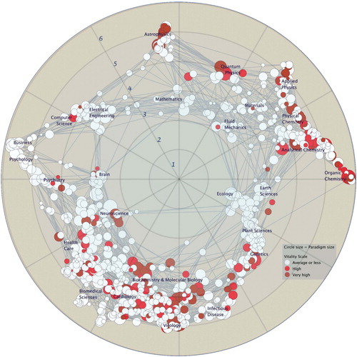
Our view is that a discipline should have a core, to distinguish it from other named fields of knowledge, but we recognise the importance and value of recognising the multiple connections to other sectors of human activity and the futility of setting firm disciplinary boundaries. A rendering of such a view (using the metaphor of a map) would show a network of disciplinary cores, with connections inserted where appropriate (perhaps with some value reflecting the strength or frequency of that connection), and with vague zones around each core ().
Figure 1. Illustrating the connectivity of scientific disciplines (but not the fuzziness of disciplinary boundaries) (Börner, Citation2010, p. 137).
It is important to note that any representation such as this, and any approach to human activity that does not dissipate into a multi-disciplinary soup, requires a defined discipline to possess certain characteristics that distinguish it from other disciplines. Thus, principles, theories, methods, norms, and standards must be presented. The collection of these is often called a paradigm, and this is a useful term as it implies that, although there is a framework within which a discipline can be studied, it is just a framework, capable of being adjusted and shifted, and the characteristics that define a discipline can be modified.
Kuhn (Citation1962) describes a paradigm as a collection of beliefs shared by scientists – a set of agreements about how problems are to be understood. According to Kuhn, paradigms are essential to all inquiry, for ‘no natural history can be interpreted in the absence of at least some implicit body of intertwined theoretical and methodological belief that permits selection, evaluation, and criticism’ (p. 6). Paradigms guide the research efforts of scientific communities, and most clearly identify a field as a science: such communities adopt a ‘positivist’ viewpoint, that there is a reality that can be scientifically verified or is capable of logical or mathematical proof.
Kuhn suggests that the typical developmental pattern of a discipline is the successive transition from one paradigm to another through a paradigm shift, occasions when ‘a scientist's world is qualitatively transformed’. However, scientists tend to ignore developments that might threaten an existing paradigm and trigger the development of a new and competing paradigm. For many, the frightening aspect of such a shift is that, like a revolution, it may be necessary to obviate all prior work before proceeding with a new paradigm. A paradigm shift in cartography might mean that all work related to how maps are made would no longer be valid and would need to be thrown out. Further, by keeping any of it, we would be corrupting our ability to move forward with a new paradigm (Peterson, Citation2003).
In the past decades, ‘post-modernist’ thought has co-opted some of Kuhn's ideas, suggesting that paradigm shifts in science are primarily instigated by the development of social and political change. For such adherents, scientific enquiry is not neutral or objective; rather, it is full of unexamined prejudices, preferences, and presumptions, and presents debateable notions – that there is an objective reality; that the findings of scientists can be objectively true or false; that humans will naturally become more humane, just, and enlightened; and that reason and logic are universally valid. As a whole, while cartographers recognise the inherent generalisation of maps and the falseness of their representations, and are used to dealing with data which possesses uncertainty, they remain primarily positivist in their viewpoint. Like other mature disciplines, however, it is clear that within cartography several paradigms may be embedded simultaneously.
Researchers are guided by such paradigms. Over the past 70 years, researchers in cartography have been influenced by at least four major paradigms, each of which has influenced the discipline’s development, yet have overlapped and co-existed: cartographic communication (Koláčný, Citation1969), analytical cartography (Tobler, Citation1976), cartographic visualisation (Antle & Klinkenberg, Citation1999), and sociocultural critique (Crampton, Citation2001). While these research paradigms were in various stages of development, the discipline was also adapting pragmatically to a major change in how maps were produced – the computerisation of cartography – and how they were consumed – the webification of map delivery. The nature of the paradigm shifts identified in the next section help to elucidate the wide scope of cartography, along with its limits.
2. Cartography as a discipline
We contend that, with its paradigms, methods, principles, theories, and practices, cartography is a discipline, and therefore it is required of us that we identify and present the core concepts and unique characteristics of cartography. It would also be useful to identify the position of cartography in the network structure of scientific and societal disciplines exemplified in (several other taxonomies of disciplines exist, incorporating those studies and practices regarded as ‘art’ and ‘technology’ – and these are also relevant to cartography – as well as science and society, e.g. the long-established Frascati Manual (OECD, Citation2007)). Such positioning assists in identifying the strength and nature of the relationships between cartography and other disciplines.
Later in this paper, we reflect on the central role of ‘the map’ in cartography, but here we merely suggest that cartography is the discipline that uniquely defines the study of maps and mapping. Although the term cartography is relatively new and is burdened by norms, standards, and ideals that were established a century and a half ago, the word still has the capability of being used to denote a node in the network of disciplines. In particular, the fuzziness and variable extent of the region centred on that node means that a range of widely varying cartographic practices – recognition of the importance of mapping by gesture, development of research avenues in post-representational interpretations of cartography, application of recent conventions on visualisation from computer science, to take just three examples – can be incorporated into the discipline.
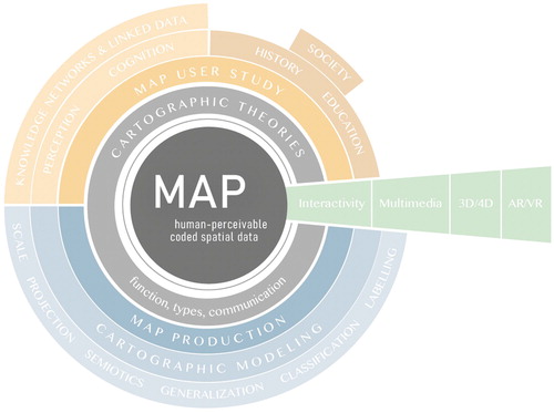
The widening of its scope means that the discipline will inevitably abut, overlap, and possibly ‘colonise’ (or be colonised by) other disciplines. The presentation and positioning of any discipline may well result from a natural human insecurity about the importance of an individual’s role in society and the desire in many cultures to be associated with something ‘new’. The value of identifying and promoting the discipline of cartography is that the word can be, and is, defined anew, and its scope can be extended to embrace expanded and new paradigms. It is a usefully flexible term that has survived during times of rapid change ().
Figure 2. The discipline of cartography: core concepts, extensive scope, fuzzy edges.
That flexibility and openness to re-definition is exemplified by the change from assumed limits of the nineteenth century definition – the drawing (based on scaled observed measurements of ‘reality’) and reproduction of printed graphic map artefacts for limited official usage – to, a century later, the broad 1949 United Nations definition of cartography as ‘the science of preparing all types of maps and charts and … every operation from original survey to final printing of maps’ [our emphasis] (United Nations, Citation1949, p. 7). Geodesists, surveyors, photogrammetrists, regional and synoptic geographers, and printing technologists, would all agree that ‘cartography’ should not be colonising their space on the disciplinary register, then or now.
Soon after the United Nations called for the ‘science of cartography’ and the endeavours of its adherents to assist in meeting its charter aims for peaceful economic and social progress, a reflective account of the nature of maps by Robinson (Citation1951), along with seminal work on signal communication by Shannon and Weaver (Citation1949), paved the way for a characterisation of cartography as a communication system. The cartographic communication paradigm viewed the process of mapping as a series of stages in data handling, dependent on and affected by tasks and humans – including the extraction of information from ‘reality’, the transformation of such information in the mind of the map maker, the encoding in visual form of the message that the map is intended to convey, then the decoding of the map on the part of an end-user. Moving between these stages represents the potential for loss of information, and the paradigm suggested that there were methods for optimising the flow of information and reducing ‘error’ in map-making and map use. Cartographers borrowed research methodologies from psychophysics and cognition, in attempts to use a scientific approach to improve the design of maps, and to achieve production of the ‘optimum’ map. The research was based on the notion that maps were composed of elements explicitly chosen by the map-maker to encode information and effect communication. Improving the design of these elements would improve the communication potential of the map.
The ‘communication school’ ended abruptly in the mid-1980s in a classic paradigm shift. Much of the work was discarded, including guidelines on the scaling of symbols to compensate for the underestimation of their size. It also struggled for attention with the introduction of the personal computer and embryonic techniques of digital mapping that helped shift the attention of cartographers to novel and practical automated methods of map production. Further, this approach treated information transfer in a somewhat limited way, ignoring uncertainty, the added-value stimulated by some map use operations, and the role of internalised mapping (i.e. situations where the map-maker is also the map user).
The paradigm of analytical cartography, associated with Tobler at the University of Michigan in early 1970s, focussed specifically on the transformations of information inherent in cartography. Unlike the communication paradigm, the concentration was less on the map product and the human actors in that model, and more on the procedures of spatial data handling. Progressing from the ‘solving of cartographic problems’ into a broader and deeper scientific specialisation that included the development and expansion of analytical/mathematical spatial theory and model building (Moellering, Citation2000), the major goal of this approach was to expand the theory of spatial data analysis and analytical visualisation. The lack of focus on the actual map, and indeed on the human being in cartographic practice, appeared to many to misguidedly stress the primacy of data manipulation. Positive concepts and approaches that were aided by this approach included attention to multi-dimensional geospatial data handling and the development of entity-relationship models optimised for effective automated generalisation.
The subsequent paradigm of cartographic visualisation benefitted from the impact of a paradigm shift in a related field, computer graphics. Here, the development of means of conveying scientific progress and outcomes as clearly and objectively as possible led to techniques and theories of scientific visualisation, using what were presented as value-free, yet innovative, digital graphics to portray big data, to allow for exploration of multi-dimensional concepts, and to trigger understanding in complex scientific scenarios.
In cartography, the ‘swoopy’ diagram initially expressed by DiBiase (Citation1990), suggested that all cartographic activity can be placed on an axis with two fundamental activities as the endpoints: visual thinking and visual communication. The former is internalised, occurring in the ‘private realm’, and consists of the activities of exploration and confirmation. The latter forms the ‘public realm’ of cartography, involving synthesis and presentation. MacEachren (Citation1994) introduced the integral visualisation ‘cube’, with its two further axes defining (a) levels of human-map interaction and (b) the variability of the map in presenting known information and/or revealing unknown insights. The most effective exposition of cartography, it is argued, is when visualisation is optimised in the corner of the cube where there is the highest human-map interaction, the perusal of the map is done privately, and the map is used for (or initiates) the revealing of unknowns.
It has been pointed out that the distinction between maps for presentation and maps for exploration is artificial. Map use is by definition an inquisitive and analytical process: every map is used for analysis, even those supposedly made for presentation. It may be argued that everyone who uses a map engages in the process of cartographic visualisation (Peterson, Citation1999). Furthermore, the focus on objectivity in scientific visualisation leads to a rather sterile, mechanistic approach to representation, once again discounting human inputs. The pragmatic developments that contributed to the interaction with the display, hyperlinking with other data, and the development of powerful and dynamic graphics-handling tools to assist in map-making and map use, were positive contributions resulting from this approach.
The next paradigm shift brought a sociocultural critique to cartography (Harley, Citation1990). Harley was influenced by the ideas of constructivism, the theoretical formulation of post-modernism. At the time, ‘modernity’ and scientific methodology attempted to describe the world in rational, empirical, and objective terms, assuming that there is a truth to be uncovered, a way of obtaining answers to the questions posed by the human condition. In such a light, contemporary cartographic activity was presented as a means of delivering unbiased reference objects, embedded within the scientific philosophy of logical positivism. Post-modernism questions this confidence – with logic and reason viewed as subjective historical artefacts and all maps recognised as depicting a prejudiced point of view.
Further enquiry into the role of maps, their function, and their manifestation resulted from the development of this paradigm: Wood (Citation1992), for example, argued that maps are deliberately produced to mislead and exist primarily to exert power. Cartographers could not be ‘neutral presenters of information’; and maps are instruments of the nation-state to wage war, to assess taxes, and to exploit strategic resources. As the powerful, who direct map-making activity, are primarily interested in maintaining the societal status quo, stabilising power structures, and extending long-standing influence, cartography is ‘primarily a form of political discourse concerned with the acquisition and maintenance of power’ (p. 43). Wood argues that ethical considerations in cartography concerning accuracy and communication may not be as important as the implicit requirement to serve the needs of the nation-state.
In fact, cartographers have always recognised the close relationship between maps and government, many students of cartography finding employment in government at local, state, and national levels over centuries, and educators pointing them in that direction (Voskuil, Citation1950). Cartography as a capitalistic endeavour has also been long-established, with private enterprise, and its social, cultural, and political mores, applied to cartographic activity, sometimes with great profit. To cartographers, the notion that maps represent power with inherent biases was nothing new: Eckert (Citation1908) had, over 100 years ago, suggested that the ‘formalisation’ of cartography as a science was necessary, to counter such partialities. To remain relevant and noticed, the paradigm needed to voice increasingly outlandish claims, eventually suggesting that maps could not be defined, and cartography did not exist.
Several other cartographic paradigms have been proposed, identified, categorised, and embraced over time (Azocar, Citation2013; Jiang, Citation2019). As in every discipline, each paradigm has brought some positive input to the definition and development of the discipline, contributing to revised theories, principles, norms, and standards.
The paradigms outlined in this section have, to a greater or lesser extent, characterised cartography as a linear system – for example, from data collection to map; from map to analytical insight; from database to visual output; from official document to social response. Our view of the discipline, which is presented in , attempts to show that there are likely to be multiple connections and internal networks, and cross references among concepts, ideas, principles, methods, and people, within the scope of cartography, and beyond to neighbouring and influencing disciplines. also helps to define the ‘core’ of cartography – that which identifies its uniqueness and value. The focus of cartography is the study of the map, which therefore occupies the central location here. The concepts, methods, and principles ranged around the map reflect the paradigms that have been outlined, and define what we need to know to study the map.
Thus, there are primary meta-studies that are reflected in the theories which can be applied to cartography – these are rooted in our desire to understand what functions maps serve, why there are different types of map, and how maps communicate. Influencing such theories is the knowledge that is used to be able to make maps, and to understand how they are used: such knowledge can be scientific, technical, social, environmental, and cultural. Operations including data handling and analysis, for example, relate to, overlap with, and borrow knowledge from, other disciplines, and concentrate it onto the core of cartography.
Some of those activities which are regarded as uniquely cartographic, for example, the modelling of geospatial entities and relationships, are affected by externalities and borrowed concepts – for example, scale, perception, aims, and context. Further methods listed, including projections, generalisation, and design, are fundamental, whilst cartographic practice in abstraction and symbolisation also contributes to modelling. Additional technical aspects are listed in , towards the edge of the core: but investigation of the affordances of contemporary maps, including interactivity, multi-dimensionality, multi-media, dynamism, and hyperlinking, is also relevant to the study of map use. Here, links to the knowledge of the human processing system can help us to understand how maps work and for what purposes they can be used. From such critical study, cartography can reflect on what the use of maps tells us about society, history, education, behaviour, and impact.
3. The knowledge of the discipline of cartography
The identification and establishment of acceptable paradigms is one way of asserting the existence of a discipline. Another, closely related, is to establish a ‘Body of Knowledge’ (Fairbairn, Citation2017). This indicates what makes one study different from another; it defines the scope/extent of a field-of-study/named-human-activity; and it presents the material to be considered when educating and informing about the discipline. It could be regarded as the formalisation of the scope and content of cartography, presented in . A Body of Knowledge (BoK) relies on the initial establishment of the meaning of terms and concepts, leading to common principles and ‘norms’ that can be identified, taught, learned, developed, and applied. It thus may have value in investigating the evolution and identification of a discipline.
A BoK is potentially problematic as it is inherently positivist and normative in approach: there is little scope in a BoK for conflicting views and opinions; any exceptions to standard procedures, practices, methods, and artefacts are not considered relevant; and there is an inherent belief that personal opinion should yield to the primacy of accepted ‘reason’. It can also be argued that all research related to an area of interest represents its Body of Knowledge, and any endeavour to distil the totality of that research is primarily a subjective process, that strips a discipline of all the varied and related aspects that provide meaning to its existence.
The prime utilisation of any BoK is by the educators in that discipline: curriculum development, awareness raising, and student engagement can all be helped by reference to an acceptable BoK. It also acts as a formalised statement of those principles, theories, methods, norms, and standards, that help to identify the core of a discipline, and, in particular, establish the scope of a discipline to those external to it. It can be regarded as an historical archive of where the discipline has developed from, and an attempt to determine its future direction. As a distillation of the discipline, the BoK should reflect its prevailing paradigms (Azocar & Buchtroithner, Citation2013).
Progress to a BoK relies on acceptable and acknowledged definitions of the subject matter of the discipline, indeed the nature of the discipline itself. In cartography, the successive paradigms outlined above each contribute to defining the nature of the discipline, and hence populating the BoK.
For example, the communication paradigm indicates that one of the purposes of cartography is to communicate geospatial information to a human percipient. This can be done by applying visually perceivable graphical codes to represent geospatial complexity. The limited system of human perception and cognition requires the representation to be an abstraction of that complexity, although methods of achieving this can sacrifice accuracy, homogeneity, and integrity of the human world-view. Such a procedure involves consideration of semiotics (incorporating the application of syntactics, semantics, and pragmatics), modelling (including transformation – a term derived from the analytical paradigm – and generalisation), and communication (Kainz, Citation2020), each of which should be incorporated in a BoK.
Beyond this, just one example of possible elements that contribute to the core concepts presented in , the possible, acceptable, or appropriate constituents of a BoK are not elaborated here; and it may be that the creation of a definitive BoK is not possible (wholesale agreement on the methods of devising the content, and indeed on the scope of the content itself, is difficult to achieve); not desirable (erecting fixed boundaries, preventing colonisation, and rejecting disciplinary interaction, all lead to fossilisation); or not necessary (it could be argued that only those disciplines lacking in self-confidence, and trying to stake their own recognisable disciplinary core, need an explicit BoK: a BoK may itself be an admission that the area of study is not a discipline).
Due to the varying nature of cartography and its paradigms, and from that the existence of a wide scope of potential knowledge that is embedded within cartography, we feel that cartography should, and can, be defined in the broadest terms as ‘the study of maps and mapping’. This is deliberately broad to acknowledge the direct etymology of the word ‘cartography’, literally meaning writing maps (i.e. making maps), and, by extension, writing with maps (i.e. making maps for use in other disciplines), and writing about maps (i.e. studying the artefacts and their efficacy) (Edney, Citation2019).
Although cartography is a relatively recent neologism, attention to maps and mapping is long-established and societally-recognised (in all human societies), and the label is useful as a commonly accepted name for the study of these ‘things’. Edney (Citation2019) points out the accumulated ideals and false standards and norms that grew up around the initial enthusiastic adoption of the term ‘cartography’ from its inception (in effect its first paradigm). Such ideals have saddled cartography, and its primary subjects – maps and mapping – with misconceptions, for example that it is always a rational, scientific endeavour; that it is restricted to graphical outputs; that it creates accurate external (to the reader) views of reality at a reduced scale.
Such properties can be embedded in maps and mapping, but can just as (in fact, more) likely be absent from maps and mapping. The wide range of activity that has guided our definition of cartography is reflected in the wide variety of ‘thing’ which has been, in the past, defined as a ‘map’, so clearly we must move to a consideration of a definition of this term, in order to make our study of cartography understandable.
4. The definition of a map
Defining a ‘thing’ has its complement in defining what is ‘not the thing’. This involves establishing a standard epitome or stereotype, closeness to which (in ‘classification space’) defines whether it is validly named. Such practices of classification or categorisation are explored by Rosch et al. (Citation1976) who suggest that identification of a ‘prototypical’ member of a category, along with its generic characteristics, forms the basis of definition. Despite the wide variety of ‘things’ that can be defined as maps and a perceived impossibility of identifying any commonality (primarily due to the vast number of exceptions that have been ranged against any previous formalised definition), we attempt here to identify some uniform features that can help.
The paradigms already mentioned have contributed to standard definitions of a map, that have been formulated on many occasions, by many contributors, in the past. For example, the primacy of the graphic nature of maps was derived from the communication paradigm, the focus on the utility of maps for representing spatial relationships was borrowed from visualisation principles, the high-impact incorporation of the human being in creating and using the map comes from the sociocultural critique.
Thus, a starting point can be the truism that all maps are social constructs, they are ineluctably directed by human intellect and behaviour, and are the results of individual human practices and/or social discourse. Maps are defined not by where they represent or the degree of scale reduction, but by non-technical factors such as social need, power relations, and cultural conventions. Maps are the result of choices made by people, just as the use of maps is also resolved by human behaviour. A map is not merely (or even) a model of reality, but it is a correspondence to a model of entities and relations as conceived by human beings. Certain choices must be made in order to realise such a correspondence effectively – choices of transformation, abstraction and generalisation, coding, visibility – and there must also be freedom of choice for humans to determine the range, depth, and control over the operations that they perform when using maps.
There is still a disconnect between the map presented as an ‘idée fixe’ representing information explicitly and the map as an enabling tool, allowing for added value by relying on a viewer’s implicit contemplation. Clearly, the creation of a map as an enabling interface allows for active (not passive) map use, although always within the limits of human perception and cognition (including de-coding). Other disciplines handle geospatial data – what distinguishes cartography is its aim to design, construct, and utilise an interface for effective communication of geospatial concepts. The limiting separation between map-maker and map-user, presented in the communication paradigm, can be disregarded if one conceives of the interface allowing for interactive, dynamic, and ‘private’ (to use terminology of the visualisation paradigm) map engagement. The interface is not a superficial layer separating humans and geospatial data but should be regarded more as a probing, exploratory tool.
We have identified some generic characteristics of a map (abstraction, coding, dynamic) but these are not necessarily ‘properties of an object’. It is beneficial to define a map at this ‘meta-level’. In terms of general engagement with maps, we feel that we have moved (chronologically) beyond the era of maps as artefacts, to an era where maps are regarded as services: and in future maps may well be embedded within our bodies and/or we may act as participants embedded in the space afforded by the map. Because the map today is almost universally intangible, it would be preferable to define it by identifying characteristics of function, rather than characteristics of form.
5. The functions of maps
Maps fulfil a variety of functions. Some are related to the data and the information that is depicted in the map (how accurate, how complete), some are related to the way the data is visualised and graphically depicted (how perceivable, how clear), and some are related to the user and their context (how pleasing, how entertaining, how useful, how informative, how ‘enabling’).
Ultimately, maps need to fulfil the basic function of allowing human users to communicate about geospatial information by depicting at least one object/phenomena representation (by a visually perceivable, graphically abstracted, code) in the context of at least one relation. This relation can be a depiction of any other object/phenomena or at least a geospatial reference. In this respect, the basis function of a map performs like an entity-relationship model of geospatial complexity: it depicts entities (objects/phenomena) and sets them in relations (directions, distances). Implicitly, in this mode, other artefact-related characteristics, such as scale, and symbolisation, are set. For example, users can infer scale from the depicted relationships, which may convey the scale of the map even more so than any scale statement or graphical tool.
Even if we know a lot about how maps can be produced and modelled, and how they work, we ultimately are not able to say if a map is ‘good’ in terms of satisfying the needs and demands of a particular user in a particular situation and context. Thus, the quality of a map is established primarily by its ability to undertake its (potentially variable) purpose, or function. But further, the map may be designed and crafted such that it is adequately perceivable, has no graphic conflicts, presents appropriate generalisation and coding, yet may still be regarded as inferior to a different representation of the same information, concept, or experience. Here the function is ‘meeting user’s aesthetic demands’. We go further to suggest that such a functional approach can be taken to the very definition of the map itself.
Ultimately, we propose to adopt an expanded understanding of the definition of maps as having a variety of functions. It can then be assumed, that once the map allows those particular functions – even functions that were not intended – it is useful. The quality of this use might be nevertheless variable: for example, motor cars fulfil the function of allowing mobility, although they might have different speed, size, comfort etc.; a tree stump can have the function of affording ‘sit-ability’, the same as an upholstered chair, but the latter allows a different comfort and quality – and either may be used for something besides sitting, altogether.
Previous work by the International Cartographic Association Working Group on Theoretical Issues in Cartography and its members addressed a number of issues related to the nature of cartography and how maps work. Based on earlier work by Chris Board and by Gyula Pápay, Freitag (Citation1993) developed valuable ideas regarding useful map functions, identifying a number of generic functions, and exemplifying them with specific applications. Invariant functions are inherent properties of any map: a map carries information, and it allows for explanatory interaction. Variant functions are not universal and may be more specific to a particular map, and Freitag presents four: (i) a cognitive function which covers the processes, operations, and models which are used to effect the correspondence of maps to a human conception of space (this might also include some of the methods and principles outlined in , such as transformation, generalisation, animation etc); (ii) a communication function which allows for knowledge transfer during the devising and use of maps, and may be affected by pre-knowledge, media, needs, aims and a range of other issues highlighted in the communication paradigm; (iii) a decision support function relying on evaluation of information, patterns, relationships and representation, to stimulate spatial choices; (iv) a social function which provokes social behaviour, resulting in the development of cultural activity, changes in conduct and task performance, and interaction among humans, maps and society.
The commonly used default function for a map has been navigation – the primary role of a map in the view of many is to help locate the reader and allow them to move to another location effectively. This very much downplays the range of generic functions introduced by Freitag, and the large number of other more specific map use tasks that can be identified (for example, regulation, education, recreation, exploration, information, administration, prediction, decoration, etc). The functions of the map in each of these human endeavours are multiple. In general terms we propose that the functions of revealing the power of spatial relations, enabling the capability of human cognition, raising awareness and facilitating added-value, assisting analysis, prompting decisions and actions, and pleasing the user, can each be promoted as determinants of the success of maps, and thus contribute to the listing of common characteristics helping to define a map. This itemising of functions is inevitably incomplete, but in its current state, for us, it leads towards a definition of a map.
The map must be perceivable by a human map-maker and a human map-user. We do note that these can be the same individual, so the more important distinction is between the human and the concept / model / transformation / impression / social construct / interpretation / geospatial data / worldview / relationships / complexity to which the map corresponds. The map is a specific form of such an interface, that enables discovery, probing, exploration, insight, and analysis. The interface is shaped by a focussed design process, which allows for a representation, which is perceivable, to be embedded in the interface, and allows for communication. In order for such communication to be enabled, the representation must be understandable to those participants. The principle that this involves a coding or other data reduction procedure is central to the task of mapping. It can involve consideration of the complexity being addressed, application of semiotics, attention to effective design, and awareness of map viewer responses.
Specifying the complex geospatial relationships and arrangements to which the map corresponds does not blind ourselves to the fact that maps of extra-terrestrial locations, intangible phenomena, social networks, internalised ideas, and fictional environments all exist. In every case, the function of the map is to communicate in a manner that is aesthetically pleasing and functional, allows for insight and added-value perusal, and can ensure effective and affective application to tasks and problems triggered and required by human society, behaviour, and endeavour.
A suggestion, therefore, is to introduce a definition of map as follows: a map is a perceivable, designed, enabling, interface that represents and communicates spatial entities and relations.
6. Reflective conclusions on the success of maps and cartography
We wish to define maps by what they are doing, and the logical conclusion is that a map becomes a map when it is successful at fulfilling a function. Specific functions for which maps have been successfully used are numerous throughout history and in every sphere of human activity. The externalising of spatial information and the extraction of notions of spatial complexity from within the human perceptual and cognitive systems were triggered by the primal needs of early activities (hunting, gathering, movement, environmental locating, communication). In fact, it could be argued that maps are as fundamental to, and successful in, human development as writing, language, culture, religion, architecture, and all the other means by which humans communicate and explain, and societies make manifest their humanity. In most tasks and occasions where maps are the standard and quotidian ‘thing’ to use, it is difficult to imagine how they would be undertaken if the map was not available. If maps were to be removed, how would human society function?
The pervasiveness of maps and the successful promotion of mapping as an instinctive or acquired human capacity are evident. And, if cartography is the discipline that is the study of maps and mapping, it has much to investigate and ponder, as it has done in the past. The resilience of the concept of cartography is due to its flexibility and scientific approach to curiosity and enquiry. We believe that the evident success of maps, in enabling fundamental functions necessary for human existence and progress, and being defined by those very functions, highlights the role of cartography, as the discipline charged with the study of maps and their effectiveness.
Disclosure statement
No potential conflict of interest was reported by the author(s).
Correction Statement
This article has been republished with minor changes. These changes do not impact the academic content of the article.
Additional information
Notes on contributors
David Fairbairn
David Fairbairn, previous Secretary-General & Treasurer of the International Cartographic Association (2007-2011), is a visiting fellow in the School of Engineering, Newcastle University.
Georg Gartner
Georg Gartner, President of the International Cartographic Association (2011-2015), is Chair of Cartography at the Technical University of Vienna.
Michael P. Peterson
Michael Peterson, professor in the University of Nebraska (Omaha), is the author and editor of many books on cartography, including Interactive and Animated Cartography (1995), Maps and the Internet (2003), Multimedia Cartography (2006), and Mapping in the Cloud (2014).
References
- Antle, A., & Klinkenberg, B. (1999). Shifting paradigms: From cartographic communication to scientific visualization. Geomatica, 53(2), 149–155.
- Azocar, F. (2013). Paradigmatic tendencies in cartography and mapping during the scientific and postmodern periods. In Proceedings of the 26th International Cartographic Conference. Dresden.
- Azocar, F., & Buchtroithner, M. (2013). Paradigms in cartography. Springer.
- Börner, K. (2010). Atlas of science. MIT Press.
- Crampton, J. (2001). Maps as social constructions: Power, communication and visualization. Progress in Human Geography, 25(2), 235–252. https://doi.org/https://doi.org/10.1191/030913201678580494
- DiBiase, D. (1990). Visualization in the earth sciences. Earth and Mineral Sciences, 59(2), 13–18.
- Eckert, M. (W. Joerg, Trans.). (1908). On the nature of maps and map logic. Bulletin of the American Geographical Society, 40(6), 344–351. https://doi.org/https://doi.org/10.2307/198027
- Edney, M. (2019). Cartography: The ideal and its history. University of Chicago Press.
- Fairbairn, D. (2017). Creating a body of knowledge for cartography. In Proceedings of the 28th International Cartographic Conference, Washington, DC.
- Freitag, U. (1993). Map functions. Cartographica: The International Journal for Geographic Information and Geovisualization, 30(4), 1–20. https://doi.org/https://doi.org/10.3138/DQ3R-34T9-7227-51TX
- Harley, J. B. (1990). Cartography, ethics and social theory. Cartographica: The International Journal for Geographic Information and Geovisualization, 27(2), 1–23. https://doi.org/https://doi.org/10.3138/C211-1512-0603-XJ14
- Jiang, B. (2019). New paradigm in mapping: A critique on cartography and GIS. Cartographica: The International Journal for Geographic Information and Geovisualization, 54(3), 193–205. https://doi.org/https://doi.org/10.3138/cart.54.3.2018-0019
- Kainz, W. (2020). Cartography and the others – aspects of a complicated relationship. Geo-spatial Information Science, 23(1), 52–60. https://doi.org/https://doi.org/10.1080/10095020.2020.1718000
- Koláčný, A. (1969). Cartographic information – a fundamental concept and term in modern cartography. The Cartographic Journal, 6(1), 47–49. https://doi.org/https://doi.org/10.1179/caj.1969.6.1.47
- Kuhn, T. (1962). The structure of scientific revolutions. University of Chicago Press.
- MacEachren, A. (1994). Visualization in modern cartography. In A. MacEachren & D. R. F. Taylor (Eds.), Visualization in modern cartography (pp. 1–12). Pergamon.
- Moellering, H. (2000). Scope and conceptual content of analytical cartography. Cartography and Geographic Information Science, 27(3), 205–224. https://doi.org/https://doi.org/10.1559/152304000783547858
- Nations, U. (1949). Modern cartography: Base maps for world needs. United Nations, Dept. of Social Affairs.
- OECD. (2007). Revised Field of Science and Technology (FOS) classification in the Frascati Manual. Paper DSTI/EAS/STP/NESTI(2006)19/FINAL.
- Peterson, M. (1999). Elements of Multimedia cartography. In W. Cartwright, M. Peterson, & G. Gartner (Eds.), Multimedia cartography (pp. 1–10). Springer.
- Peterson, M. (2003). Foundations of research in Internet cartography. In M. Peterson (Ed.), Maps and the Internet (pp. 437–446). Elsevier Press.
- Robinson, A. (1951). The look of maps. University of Wisconsin Press.
- Rosch, E., Mervis, C., Gray, W., Johnson, D., & Boyes-Braem, P. (1976). Basic objects in natural categories. Cognitive Psychology, 8(3), 382–439. https://doi.org/https://doi.org/10.1016/0010-0285(76)90013-X
- Schroeder, K. (2015). Is knowledge normative? Philosophical Issues, 25(1), 379–395. https://doi.org/https://doi.org/10.1111/phis.12050
- Shannon, C., & Weaver, W. (1949). The mathematical theory of communication. University of Illinois Press.
- Tobler, W. (1976). Analytical cartography. The American Cartographer, 3 (1), 21–31. https://doi.org/https://doi.org/10.1559/152304076784080230
- Voskuil, R. (1950). Cartographers in government. The Professional Geographer, 2(4), 29–32. https://doi.org/https://doi.org/10.1080/00330125009539937
- Wood, D (1992) The power of maps. New York: Guilford.