
Abstract
Humans and rivers have shared an intimate relationship since prehistoric times. This curation uses visual representations to explore some of the many ways that humans interact with these geographical features. Through photographs, a political map, and line art, it invites the reader to consider the myriad and changing demands we impose on fluvial systems through quests for access, natural capital, territory, well-being, and power.
人类自史前时代就与河流有亲密的关系&#(Smith&#,2020&#)。本次策展通过视觉再现&#,探索了人类与河流这种地理特征的互动方式。通过照片、政治地图和线条艺术&#,本文邀请读者去思考人类如何通过接触、自然资本、领土、福祉和权力&#,对河流系统进行了无数次的不同的索求。
Desde tiempos prehistóricos, los seres humanos y los ríos han compartido una relación muy cercana (Smith, 2020). Este recuento usa representaciones visuales para explorar algunas de las muchas maneras como los humanos interactúan con estos elementos geográficos. Con fotografías, un mapa político y con gráficos, se invita al lector a considerar la miríada de exigencias cambiantes que le imponemos a los sistemas fluviales, a través de la búsqueda de acceso, capital natural, territorio, bienestar y poder
Humans and rivers have shared an intimate relationship since prehistoric times (Smith Citation2020). This curation uses visual representations to explore some of the many ways that humans interact with these geographical features. Through photographs, a political map, and line art, it invites the reader to consider the myriad and changing demands we impose on fluvial systems through quests for access, natural capital, territory, well-being, and power.
If a humanistic defining of geography is the study of how humans make the physical Earth their home (Tuan Citation1991), who would dispute the geographical importance of rivers? Our earliest civilizations and cities developed along the Tigris-Euphrates, Indus, Nile, and Yellow Rivers in modern-day Iraq, India-Pakistan, Egypt, and China due to agricultural intensification from river irrigation and fertile floodplain soils (Chen Citation2019; Macklin and Lewin Citation2015; Wittfogel Citation1957). Today’s societies extract water supply, hydroelectricity, transportation, industrial activity, political borders, and public greenspace from rivers around the world (Popelka and Smith Citation2020; Smith Citation2020).
de Micheaux and Kull (Citation2020) provide a theoretical environmental geography framework covering “the full texture of the relationships between society and rivers,” spanning antiquity and the medieval period through the Renaissance and present day. It extols “diverse ways of knowing rivers” (de Micheaux and Kull, p. 151), which includes cultural (Wantzen et al. Citation2016), indigenous (Thomas Citation2015; Tipa Citation2009), legal (Kramm Citation2020; O’Donnell Citation2018), ecological (Brown et al. Citation2018; Fuller and Death Citation2018), and geological (Slingerland and Smith Citation2004; Whipple Citation2004) perspectives. In addition to anthropocentric experiences, therefore, rivers supply “more-than-human histories” that “challenge human exceptionalism” in the ecological and physical world (O’Gorman and Gaynor Citation2020).
A parallel trend in hydro-social research is to identify higher level themes around which differing histories and perspectives surrounding rivers may be organized. After reviewing roughly 20 years of publications, Schönach (Citation2017) observes “the traditional way of investigating river history as single-case studies on individual and unique rivers is increasingly complemented by comparative approaches, which allow new, trans-regional insights” (p. 235). To that end, she draws from the literature three overarching themes of space, power, and time. Environmental historians, after an initial focus on environmental degradation, developed coherent research themes surrounding urban and international rivers, while still emphasizing local knowledge and site-sensitive, culturally specific social science (Evenden Citation2018). White (Citation1995) connects seemingly disparate natural and social processes (e.g. bank erosion, salmon caloric content, hydroelectricity development) through principles of energy. Unlike environmental determinism, such conceptual frameworks offer useful, broadly flexible tools enabling comparison of differing human-riverine interactions across temporal and spatial scales.
In Rivers of Power (Smith Citation2020) I adopt an anthropocentric perspective to argue that while the nature of human-river interactions has varied over time and space, the social value of rivers endures for five fundamental reasons: access, natural capital, territory, well-being, and a means of projecting power. The particulars of the interactions change over time, but our underlying demands on rivers do not. Egypt’s Pharaonic dynasties once consumed natural capital from the Nile in the form of floodwaters and silt. Contemporary Egyptians do so today in the form of hydroelectricity, water supply, and high-value waterfront real estate in downtown Cairo. Meanwhile, Ethiopia, an upstream riparian, is flexing political power through its dogged construction of the Grand Ethiopian Renaissance Dam across the Blue Nile (Smith Citation2020; Zhang et al. Citation2015), the Nile’s most significant tributary and headwater.
The Hudson River variously supplied the Lenape with fish, colonial navies with stratagems, industrialists with a manufacturing corridor, and immigrant settlers a travel passage into the North American continent (Smith Citation2020). Today, an industrial retreat from its banks is spurring construction of new waterfront parks and bike trails to benefit public well-being. Through changing technological and social norms, the social benefits have assumed different forms over time. The Earth is rife with examples like these large and small (Smith Citation2020), even as anthropogenic stressors threaten riverine physical and ecological integrity (Best, Citation2019; Macklin and Lewin Citation2019).
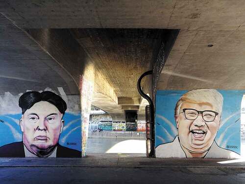
People also connect spiritually and emotionally to rivers, creating opportunities for psycho-social benefits through river restoration and access (Fox et al. Citation2017; Verbrugge et al. Citation2019). To bathe in the Ganges is a spiritual event for millions of Hindus (Ramakrishnan Citation2003); the global proliferation of waterfront parks promotes public health (Smith Citation2020; Zingraff-Hamed et al. Citation2021). Rivers pervade the arts: From Conrad to Coppola, they appear prominently in fictions. The appeal of rivers as visual subjects, so well understood by Renoir and van Gogh, abounds in other paintings and artworks created today. Legally enshrined in western cultures as communal property since Roman times (flumen publicum), rivers facilitate public performance spaces for murals () and other forms of civic art (Donald Citation2019; Gibbs Citation2014).
FIGURE 1 Anonymous mural on a Danube River bridge abutment, Vienna. Deindustrialized urban rivers often become communal spaces for recreation and public art. (Photo by Mia Bennett, 2017).
This Processes and Curations article uses visual representations to convey some of the many ways that humans interact with rivers to make the Earth their home (cf. Tuan Citation1991). As such it builds on earlier work in the GeoHumanities linking river environmental history with art and cartography (Fowkes and Fowkes Citation2016; Seemann Citation2020); and tracing the ontologies of sediments to socio-political demands (Bremner Citation2020). Comprised of seventeen photographs, one map, and four line art drawings, it is designed to be illustrative, not exhaustive. The criteria for image selection are 1) visual interest; 2) relation to one or more of the five organizing themes of Smith (Citation2020); and 3) possible value for teaching, outreach, or artistic purposes. The photographs come from the author, students, and colleagues. The map is created by comparing colonial and post-colonial territorial treaties with satellite-derived digital elevation models (Smith Citation2020). The line art is created through collaboration with a professional illustrator. Viewed collectively, the curation invites the viewer to consider interactions of natural fluvial processes (e.g. runoff, bank erosion, biodiversity) with human quests for access, natural capital, territory, well-being, and power.
FIGURE NOTES
The U.S. territorial expansion map (Figure), and are reprinted from Smith (Citation2020). Black and white versions of the photographs in appear in Smith (Citation2020) but are published here in color for the first time. , 18–21 are published here for the first time. All images are freely available for public use, citing Smith (Citation2020) and/or this article as appropriate.
FIGURE 2 Wolf tracks along the Yukon River, Alaska. Wildlife and humans have always used rivers as natural travel corridors (Smith Citation2020). Recent archeological evidence (Davis et al. Citation2019) indicates that North America’s earliest known people entered the continent following the Columbia River upstream from the Pacific coast. [Access] (Author photo, 2015).
![FIGURE 2 Wolf tracks along the Yukon River, Alaska. Wildlife and humans have always used rivers as natural travel corridors (Smith Citation2020). Recent archeological evidence (Davis et al. Citation2019) indicates that North America’s earliest known people entered the continent following the Columbia River upstream from the Pacific coast. [Access] (Author photo, 2015).](/cms/asset/2dca9139-b94a-4b5b-916b-e0f9971a4d40/rgeo_a_2011765_f0002_oc.jpg)
FIGURE 3 U.S. Mobile Riverine Force flamethrower vessel operating in the Mekong River Delta, 1969. During the Vietnam War, American and Vietnamese combatants fought asymmetric warfare in a labyrinth of waterways throughout the Mekong River Delta, a strategic supply corridor for Viet Cong guerrilla fighters in South Vietnam (Smith Citation2020). [Access; Power] (Photo courtesy of Richard Lorman).
![FIGURE 3 U.S. Mobile Riverine Force flamethrower vessel operating in the Mekong River Delta, 1969. During the Vietnam War, American and Vietnamese combatants fought asymmetric warfare in a labyrinth of waterways throughout the Mekong River Delta, a strategic supply corridor for Viet Cong guerrilla fighters in South Vietnam (Smith Citation2020). [Access; Power] (Photo courtesy of Richard Lorman).](/cms/asset/53511fe7-4630-4126-b7da-71d973d2c50a/rgeo_a_2011765_f0003_oc.jpg)
FIGURE 4 Landscape architects assess redevelopment potential of a defunct commercial property on the East River, Brooklyn. City planners are increasingly demanding wide setbacks and creation of publicly accessible riverfronts as terms for redevelopment of former industrial sites (Smith Citation2020) [Access] (Author photo, 2018).
![FIGURE 4 Landscape architects assess redevelopment potential of a defunct commercial property on the East River, Brooklyn. City planners are increasingly demanding wide setbacks and creation of publicly accessible riverfronts as terms for redevelopment of former industrial sites (Smith Citation2020) [Access] (Author photo, 2018).](/cms/asset/3a212d85-8a43-45c4-b8da-ce59e7c068f7/rgeo_a_2011765_f0004_oc.jpg)
FIGURE 5 The Los Angeles River in Long Beach, California. Planning for improved public access and major ecological restoration to this long-maligned waterway is now underway (Smith Citation2020). [Access; Well-being] (Author photo, 2017).
![FIGURE 5 The Los Angeles River in Long Beach, California. Planning for improved public access and major ecological restoration to this long-maligned waterway is now underway (Smith Citation2020). [Access; Well-being] (Author photo, 2017).](/cms/asset/dfced70f-6da4-42f3-aa71-9eb727d7ce64/rgeo_a_2011765_f0005_oc.jpg)
FIGURE 6 Cham fisherman near Tonle Sap River, Cambodia. Freshwater fish species are a vital source of income and protein throughout much of Southeast Asia (Smith Citation2020). [Natural capital; Well-being] (Author photo, 2017).
![FIGURE 6 Cham fisherman near Tonle Sap River, Cambodia. Freshwater fish species are a vital source of income and protein throughout much of Southeast Asia (Smith Citation2020). [Natural capital; Well-being] (Author photo, 2017).](/cms/asset/7069b2d8-ea48-4e95-95c4-192ab90eaa5a/rgeo_a_2011765_f0006_oc.jpg)
FIGURE 7 Trapper with beaver, Adirondack region, USA. The European fur trade spurred colonial exploration and settlement of North America while extirpating beaver (Castor canadensis) populations. Today, beavers have rebounded and both indigenous and non-indigenous people still maintain cultural connections to the land through traditional activities of hunting, fishing, and trapping (Smith Citation2020). [Natural capital; Well-being] (Author photo).
![FIGURE 7 Trapper with beaver, Adirondack region, USA. The European fur trade spurred colonial exploration and settlement of North America while extirpating beaver (Castor canadensis) populations. Today, beavers have rebounded and both indigenous and non-indigenous people still maintain cultural connections to the land through traditional activities of hunting, fishing, and trapping (Smith Citation2020). [Natural capital; Well-being] (Author photo).](/cms/asset/9aad9bf1-3155-4d8e-a823-0a30be5e8470/rgeo_a_2011765_f0007_oc.jpg)
FIGURE 8 The Rio Grande upstream (top) and downstream (bottom) of the U.S.-Mexico border. The river is transformed into a hardened boundary at El Paso, Texas with much of its discharge diverted into the swiftly flowing American Canal (bottom foreground). The canal poses a perilous barrier to migrants seeking undocumented entry into the United States, with numerous swift-water rescues and drownings annually (Smith Citation2020). Today, nearly one-fourth of the world’s non-coastal international political borders are set by large rivers (Popelka and Smith Citation2020). [Territory] (Author photo, 2017).
![FIGURE 8 The Rio Grande upstream (top) and downstream (bottom) of the U.S.-Mexico border. The river is transformed into a hardened boundary at El Paso, Texas with much of its discharge diverted into the swiftly flowing American Canal (bottom foreground). The canal poses a perilous barrier to migrants seeking undocumented entry into the United States, with numerous swift-water rescues and drownings annually (Smith Citation2020). Today, nearly one-fourth of the world’s non-coastal international political borders are set by large rivers (Popelka and Smith Citation2020). [Territory] (Author photo, 2017).](/cms/asset/e7c9380e-e70e-499f-9ddf-3942539ffa5e/rgeo_a_2011765_f0008_oc.jpg)
FIGURE 9 A supraglacial meltwater river flowing across the surface of the southwestern Greenland ice sheet. Ocean-going flows from hundreds of supraglacial rivers in this area are a key mechanism by which climate change is rapidly rising global sea levels, imperiling the world’s coasts (Smith Citation2020). [Well-being] (Author photo from helicopter, 2012).
![FIGURE 9 A supraglacial meltwater river flowing across the surface of the southwestern Greenland ice sheet. Ocean-going flows from hundreds of supraglacial rivers in this area are a key mechanism by which climate change is rapidly rising global sea levels, imperiling the world’s coasts (Smith Citation2020). [Well-being] (Author photo from helicopter, 2012).](/cms/asset/70787866-6c11-439f-a34e-f3babece1900/rgeo_a_2011765_f0009_oc.jpg)
FIGURE 10 Increased meltwater production on the Greenland ice sheet surface is a key mechanism by which climate change is raising global sea levels (Smith Citation2020). For scale, tents from one of the author’s scientific field expeditions to measure supraglacial river discharge (Smith et al. Citation2021) are visible in the upper left corner. Photograph from fixed-wing drone. [Well-being] (Drone photo acquired by Jonathan C. Ryan, 2016).
![FIGURE 10 Increased meltwater production on the Greenland ice sheet surface is a key mechanism by which climate change is raising global sea levels (Smith Citation2020). For scale, tents from one of the author’s scientific field expeditions to measure supraglacial river discharge (Smith et al. Citation2021) are visible in the upper left corner. Photograph from fixed-wing drone. [Well-being] (Drone photo acquired by Jonathan C. Ryan, 2016).](/cms/asset/ad63bf6c-e7e1-4d95-977d-441c3603f1ec/rgeo_a_2011765_f0010_oc.jpg)
FIGURE 11 Catastrophic flood erosion, Iceland. In 1996 a volcanic eruption beneath the Vatnajökull ice cap triggered a jökulhlaup (glacier outburst flood) having roughly quadruple the flow of the Mississippi River. The flood tore down two small rivers draining the ice cap’s outwash plain (Skeiðarársandur), denuding the landscape by nearly 25 m in some areas (shown here) and depositing up to 12 m of gravel in others, Iceland’s circum-Island highway crossing the plain was destroyed (Smith Citation2020). [Well-being] (Author photo, 1997).
![FIGURE 11 Catastrophic flood erosion, Iceland. In 1996 a volcanic eruption beneath the Vatnajökull ice cap triggered a jökulhlaup (glacier outburst flood) having roughly quadruple the flow of the Mississippi River. The flood tore down two small rivers draining the ice cap’s outwash plain (Skeiðarársandur), denuding the landscape by nearly 25 m in some areas (shown here) and depositing up to 12 m of gravel in others, Iceland’s circum-Island highway crossing the plain was destroyed (Smith Citation2020). [Well-being] (Author photo, 1997).](/cms/asset/9e7edc1c-1c7f-44c7-8a1d-721b081a3f6a/rgeo_a_2011765_f0011_oc.jpg)
FIGURE 12 Team Rubicon volunteers aiding flood disaster relief efforts in Conroe, Texas, during the aftermath of Hurricane Harvey. [Well-being] (Author photo, 2017).
![FIGURE 12 Team Rubicon volunteers aiding flood disaster relief efforts in Conroe, Texas, during the aftermath of Hurricane Harvey. [Well-being] (Author photo, 2017).](/cms/asset/63034868-4c4e-4351-b85d-a41fa7e6eac3/rgeo_a_2011765_f0012_oc.jpg)
FIGURE 13 Abundant new riverfront greenspace and public parks in Shanghai echo a global trend of increasing human-river interactions in urban areas (Smith Citation2020) [Well-being] (Author photo, 2018).
![FIGURE 13 Abundant new riverfront greenspace and public parks in Shanghai echo a global trend of increasing human-river interactions in urban areas (Smith Citation2020) [Well-being] (Author photo, 2018).](/cms/asset/393d2a1f-ce9c-4a33-b784-cb69b2601e82/rgeo_a_2011765_f0013_oc.jpg)
FIGURE 14 A decommissioned shipping pier converted into an event space, Hudson River, New York City. [Well-being] (Author photo, 2018).
![FIGURE 14 A decommissioned shipping pier converted into an event space, Hudson River, New York City. [Well-being] (Author photo, 2018).](/cms/asset/dc613fd3-b7e2-4f52-9b5f-dd065f96e712/rgeo_a_2011765_f0014_oc.jpg)
FIGURE 15 Thousands gather at summertime WaterFire festivals on the Woonasquatucket River, a revitalized former industrial waterway in Providence, Rhode Island. [Well-being] (Photo by Abbie Tingstad, 2019).
![FIGURE 15 Thousands gather at summertime WaterFire festivals on the Woonasquatucket River, a revitalized former industrial waterway in Providence, Rhode Island. [Well-being] (Photo by Abbie Tingstad, 2019).](/cms/asset/7bb9eb7c-e7a8-4b3d-a4d3-4bed48a07fdc/rgeo_a_2011765_f0015_oc.jpg)
FIGURE 16 The Grand Ethiopian Renaissance Dam (GERD) under construction across the Blue Nile. This enormous river engineering project, funded entirely by Ethiopia and strenuously opposed by Egypt, is a source of national pride in Ethiopia and projects riparian power across the region (Smith Citation2020). [Power; Natural capital] (Photo by Gedion Asfaw, 2018).
![FIGURE 16 The Grand Ethiopian Renaissance Dam (GERD) under construction across the Blue Nile. This enormous river engineering project, funded entirely by Ethiopia and strenuously opposed by Egypt, is a source of national pride in Ethiopia and projects riparian power across the region (Smith Citation2020). [Power; Natural capital] (Photo by Gedion Asfaw, 2018).](/cms/asset/700a8a8e-1622-49f1-b0c8-40d5f67805c8/rgeo_a_2011765_f0016_oc.jpg)
Acknowledgments
The author thanks Gedion Asfaw (GERD Tripartite Committee), Mia M. Bennett (University of Washington), Richard Lorman (U.S. Mobile Riverine Force veteran), Jonathan C. Ryan (University of Oregon), and Abbie Tingstad (RAND Corporation) for providing five of the presented photographs. The map appearing in
FIGURE 17 Rivers and their topographic watershed divides strongly influenced the territorial expansion of the conterminous United States (1763–1853) (Smith Citation2020). These natural geographical features were often used by colonial powers as convenient cadastral instruments to claim and negotiate poorly charted territory. The legacy of this practice is reflected globally today in political borders at national, state, and local scales (Popelka and Smith Citation2020; Smith Citation2020). [Territory].
![FIGURE 17 Rivers and their topographic watershed divides strongly influenced the territorial expansion of the conterminous United States (1763–1853) (Smith Citation2020). These natural geographical features were often used by colonial powers as convenient cadastral instruments to claim and negotiate poorly charted territory. The legacy of this practice is reflected globally today in political borders at national, state, and local scales (Popelka and Smith Citation2020; Smith Citation2020). [Territory].](/cms/asset/91a1a02a-69b4-475d-aee8-ad591383fdb5/rgeo_a_2011765_f0017_b.gif)
FIGURE 18 Line art depiction of a fictional new mill settlement during the early industrial era. Early settlements, including coastal settlements, were almost always established near rivers. [Territory, Natural capital] (created by May van Millingen in collaboration with the author).
![FIGURE 18 Line art depiction of a fictional new mill settlement during the early industrial era. Early settlements, including coastal settlements, were almost always established near rivers. [Territory, Natural capital] (created by May van Millingen in collaboration with the author).](/cms/asset/f0e706c4-075f-49eb-b839-e9e63f4a9c3c/rgeo_a_2011765_f0018_oc.jpg)
FIGURE 19 Line art depiction of a fictional town during the Industrial Revolution era. [Natural capital] (created by May van Millingen in collaboration with the author).
![FIGURE 19 Line art depiction of a fictional town during the Industrial Revolution era. [Natural capital] (created by May van Millingen in collaboration with the author).](/cms/asset/5a909de7-7042-4d39-bb0c-ce25d557a90f/rgeo_a_2011765_f0019_b.gif)
FIGURE 20 Line art depiction of a fictional post-industrial city with restricted river access due to a large reservoir dam and decommissioned industrial properties. [Access] (created by May van Millingen in collaboration with the author).
![FIGURE 20 Line art depiction of a fictional post-industrial city with restricted river access due to a large reservoir dam and decommissioned industrial properties. [Access] (created by May van Millingen in collaboration with the author).](/cms/asset/968447aa-d8f8-46cd-9991-2ca7d5f1cf07/rgeo_a_2011765_f0020_oc.jpg)
FIGURE 21 Line art depiction of a fictional contemporary city following riverfront revitalization and improved public access. [Access, Well-being] (created by May van Millingen in collaboration with the author).
![FIGURE 21 Line art depiction of a fictional contemporary city following riverfront revitalization and improved public access. [Access, Well-being] (created by May van Millingen in collaboration with the author).](/cms/asset/8452c2fc-0900-40a4-8d1d-de3a022a9851/rgeo_a_2011765_f0021_oc.jpg)
DISCLOSURE STATEMENT
No potential conflict of interest was reported by the author.
Additional information
Funding
Notes on contributors
Laurence C. Smith
LAURENCE C. SMITH is the John Atwater and Diana Nelson University Professor of Environmental Studies in the Institute at Brown for Environment & Society (IBES) and Professor of Earth, Planetary, and Space Sciences at Brown University, Providence, RI, 02912, USA. E-mail: [email protected]. Previously, he was Professor and Chair of Geography at the University of California, Los Angeles (UCLA). His research interests include rivers, the Arctic, and remote sensing technologies. He has published over 150 peer-reviewed articles, essays and books. He is a Guggenheim Fellow, Fellow of the American Geophysical Union, and speaker at the World Economic Forum in Davos. His research has been reported by The New York Times, The Wall Street Journal, The Economist, The Los Angeles Times, The Washington Post, The Globe and Mail, The Financial Times, Discover Magazine, NPR, CBC Radio, BBC and others. His general-audience book THE WORLD IN 2050: Four Forces Shaping Civilization’s Northern Future (Plume USA/Canada, 2011; U.K. edition titled THE NEW NORTH, Profile Books, 2011) synthesizing trends in natural resource demand, demographics, globalization, and climate change with emphasis on northern countries was winner of the Walter P. Kistler Book Award and a NATURE Editor’s Pick of 2012. His second book RIVERS OF POWER (Hachette Group USA/Canada; Penguin Press U.K, 2020), about rivers and society, was a GEOGRAPHICAL best book of 2020.
REFERENCES
- Best, J. 2019. Anthropogenic stressors on the world’s big rivers. Nature Geoscience 12:7–21. doi:10.1038/s41561-018-0262-x.
- Bremner, L. 2020. Sedimentary Ways. Sedimentary Ways. GeoHumanities. doi:10.1080/2373566X.2020.1799718.
- Brown, A. G., L. Lespez, D. A. Sear, -J.-J. Macaire, P. Houben, K. Klimek, R. E. Brazier, K. Van Oost, B. Pears. 2018. Natural vs anthropogenic streams in Europe: History, ecology and implications for restoration, river-rewilding and riverine ecosystem services. Earth-Science Reviews 180:185–205. doi:10.1016/j.earscirev.2018.02.001.
- Chen, Y. 2019. Flood dynamics of the lower Yellow River over the last 3000 years: Characteristics and implications for geoarchaeology. Quaternary International 521:147–57. doi:10.1016/j.quaint.2019.05.040.
- Davis, L. G., D. B. Madsen, L. Becerra-Valdivia, T. Higham, D. A. Sisson, S. M. Skinner, D. Stueber, A. J. Nyers, A. Keen-Zebert, C. Neudorf, et al. 2019. Late upper paleolithic occupation at cooper’s Ferry, Idaho, USA, ~16,000 years ago. Science 30 (365):891–97. doi:10.1126/science.aax9830.
- de Micheaux, F. L., and C. Kull. 2020. Combining political ecology and “Mésologie” for a new geography of rivers? Ecology, Economy and Society 3 (2):149–60. doi:10.37773/ees.v3i2.231.
- Donald, M. 2019. Guddling about: An ecological performance practice with water and other Nonhuman collaborators. GeoHumanities 5 (2):591–619. doi:10.1080/2373566X.2019.1652106.
- Evenden, M. 2018. Beyond the organic machine? New approaches in river historiography. Environmental History 23 (4):698–720. doi:10.1093/envhis/emy054.
- Fowkes, M., and R. Fowkes. 2016. The primeval cosmic river and its ecological realities: On the curatorial project Danube River school. GeoHumanities 2 (2):453–68. doi:10.1080/2373566X.2016.1234350.
- Fox, C. A., N. J. Reo, D. A. Turner, J. Cook, F. Dituri, B. Fessell, J. Jenkins, A. Johnson, T. M. Rakena, C. Riley, et al. 2017. “The river is us; the river is in our veins”: Re-defining river restoration in three Indigenous communities. Sustainability Science 12 (4):521–33. doi:10.1007/s11625-016-0421-1.
- Fuller, I. C., and R. G. Death. 2018. The science of connected ecosystems: What is the role of catchment-scale connectivity for healthy river ecology? Land Degradation & Development 29 (5):1413–26. doi:10.1002/ldr.2903.
- Gibbs, L. 2014. Arts-science collaboration, embodied research methods, and the politics of belonging: ‘SiteWorks’ and the Shoalhaven River, Australia. Cultural Geographies 21 (2):207–27. doi:10.1177/1474474013487484.
- Kramm, M. 2020. When a river becomes a person. Journal of Human Development and Capabilities 21 (4):307–19. doi:10.1080/19452829.2020.1801610.
- Macklin, M. G., and J. Lewin. 2015. The rivers of civilization. Quaternary Science Reviews 114:228–44. doi:10.1016/j.quascirev.2015.02.004.
- Macklin, M. G., and J. Lewin. 2019. River stresses in anthropogenic times: Large-scale global patterns and extended environmental timelines. Progress in Physical Geography: Earth and Environment 43 (1):3–23. doi:10.1177/0309133318803013.
- O’Donnell, E. 2018. Legal rights for rivers: Competition, collaboration and water governance, 1st ed. Routledge. doi:10.4324/9780429469053.
- O’Gorman, E., and A. Gaynor. 2020. More-Than-Human histories. Environmental History 25 (4):711–35. doi:10.1093/envhis/emaa027.
- Popelka, S. J., and L. C. Smith. 2020. Rivers as political borders: A new subnational geospatial dataset. Water Policy 22 (3):293–312. doi:10.2166/wp.2020.041.
- Ramakrishnan, P. S. 2003. The sacred Ganga River‐based cultural landscape. Museum International 55 (2):7–17. doi:10.1046/j.1350-0775.2003.00420.x.
- Schönach, P. 2017. River histories: A thematic review. Water History 9 (3):233–57. doi:10.1007/s12685-016-0188-4.
- Seemann, J. 2020. The blueness of water in cartography, culture, and art: Conventions, ontological security, and creativity. GeoHumanities 6 (2):371–93. doi:10.1080/2373566X.2020.1803099.
- Slingerland, R., and N. D. Smith. 2004. River avulsions and their deposits. Annual Review of Earth and Planetary Sciences 32 (1):257–85. doi:10.1146/annurev.earth.32.101802.120201.
- Smith, L. C. 2020. Rivers of power: How a natural force raised kingdoms, destroyed civilizations, and shapes our world. New York: Little, Brown, Spark/Hachette Book Group. United Kingdom/Europe: Penguin Random House UK.
- Smith, L. C., L. C. Andrews, L. H. Pitcher, B. T. Overstreet, Å. K. Rennermalm, M. G. Cooper, S. W. Cooley, J. C. Ryan, C. Miège, C. Kershner, and C. E. Simpson. 2021. Supraglacial river forcing of subglacial water storage and diurnal ice sheet motion. Geophysical Research Letters 48 (7):e2020GL091418. doi:10.1029/2020GL091418.
- Thomas, A. C. 2015. Indigenous more-than-humanisms: Relational ethics with the Hurunui River in Aotearoa New Zealand. Social & Cultural Geography 16 (8):974–90. doi:10.1080/14649365.2015.1042399.
- Tipa, G. 2009. Exploring indigenous understandings of river dynamics and river flows: A case from New Zealand. Environmental Communication 3 (1):95–120. doi:10.1080/17524030802707818.
- Tuan, Y. 1991. A view of geography. Geographical Review 81 (1):99–107. doi:10.2307/215179.
- Verbrugge, L., M. Buchecker, X. Garcia, S. Gottwald, S. Müller, S. Præstholm, A. Stahl Olafsson. 2019. Integrating sense of place in planning and management of multifunctional river landscapes: Experiences from five European case studies. Sustainability Science 14 (3):669–80. doi:10.1007/s11625-019-00686-9.
- Wantzen, K. M., A. Ballouche, I. Longuet, I. Bao, H. Bocoum, L. Cissé, M. Chauhan, P. Girard, B. Gopal, A. Kane, et al. 2016. River Culture: An eco-social approach to mitigate the biological and cultural diversity crisis in riverscapes. Ecohydrology & Hydrobiology 16 (1):7–18. doi:10.1016/j.ecohyd.2015.12.003.
- Whipple, K. X. 2004. Bedrock rivers and the geomorphology of active orogens. Annual Review of Earth and Planetary Sciences 32 (1):151–85. doi:10.1146/annurev.earth.32.101802.120356.
- White, R. 1995. The Organic Machine: The Remaking of the Columbia River. New York: Hill and Wang.
- Wittfogel, K. A. 1957. Oriental Despotism: A Comparative Study of Total Power. New Haven: Yale University Press.
- Zhang, Y., P. Block, M. Hammond, and A. King. 2015. Ethiopia’s grand renaissance dam: Implications for downstream riparian countries. Journal of Water Resources Planning and Management 141 (9). doi:10.1061/(ASCE)WR.1943-5452.0000520.
- Zingraff-Hamed, A., M. Bonnefond, S. Bonthoux, N. Legay, S. Greulich, A. Robert, V. Rotgé, J. Serrano, Y. Cao, R. Bala, et al. 2021. Human–River encounter sites: Looking for harmony between humans and nature in cities. Sustainability 13 (5):2864. doi:10.3390/su13052864.