
Abstract
In the last decades research efforts studying Amazonian biodiversity have increased substantially, with many new localities surveyed, new specimens collected, and some new regional collections established. In our study, we revised, updated, and summarized the available data on the diversity, distribution, species richness, and conservation status of lizards from the Brazilian Amazonia. We recorded 138 species-level taxa of lizards in the Brazilian Amazonia that presented five general patterns of distribution, plus some cases of unique distributions. Species richness is unevenly distributed across the region, varying between one and 44 species in a single grid, with 37–44 species in the richest areas. Based on the overlap of occurrence area of each species with protected areas (strict nature reserves; managed resource protected areas; protected indigenous peoples’ territories) and deforested layers, we show that 58% of the analyzed species (n = 75) present more than 50% of their occurrence area outside of any protected area, and 20% (n = 26) of them present 33% or less occurrence in protected areas. Strict nature reserves (strictly protected areas) are responsible for the main protection (≥50% of the protected area) of only 3% of the species (n = 4). Indigenous peoples’ territories represent the main protection area for 31% of the species (n = 40). Ten species present more than 50% of their occurrence in area deforested, and for 12 species the range varied between 33 and 50% of habitat loss. Revising the International Union for Conservation of Nature conservation status categories for a regional assessment, three species were classified as EN (Endangered), six as VU (Vulnerable), and 15 as NT (Near Threatened). Species with occurrence in Southern Amazonia are the most threatened. We presented the core areas for conservation of species richness and discussed their conservation status. Habitat loss due to mechanized agriculture (mainly from soy plantation), pastures, fire, and infrastructure project (e.g. roads and hydroelectric dams) are the main threats to the lizard fauna. Southern Amazonia is the region with the highest human pressure and, at the same time, it is the least protected. We suggest a revision to the mosaic of interconnected conservation areas, mainly in Southern Amazonia, and recommend that new infrastructure projects in the region take preventive actions to mitigate the direct and indirect impacts on the local lizard fauna.
Introduction
Amazonia represents the the largest continuous rainforest in the world, and 60% of it, approximately 389.3 × 10⁶ ha,[Citation1] lies in Brazil. It harbors the largest known biodiversity, but the so-called Wallacean shortfall (gaps in our knowledge on the distribution of organisms; see [Citation2]) is still large and hinders our ability to establish efficient conservation policies. At the same time, the region experiences an ongoing deforestation process, with rates (in 106 ha/year) between 1.68–2.07 in the period 1990–2000 and 2.24–2.55 during 2000–2005.[Citation1] Even if deforestation rates seem to have decreased in recent years,[Citation3,4] new (or improved) roads, hydroelectric projects, mining activity, and other enterprises are now operating in the region, not only affecting its borders, but also threatening to fragment the whole region, with unknown consequences.[Citation5]
Concerning the distribution of reptiles, few studies have covered the entire Amazonian region, and they are concentrated particularly in two books – see [Citation6], especially the chapters by Dixon and Hoogmoed; and [Citation7], with a chapter by Vanzolini on South American lizards. However, several of the distribution patterns considered in these studies have already been demonstrated to be sampling artifacts.[Citation8] Regionally, a number of lowland locations have been reasonably well surveyed (e.g. [Citation9–14]), and some countries have this information organized in catalogues, at least for lizards (Bolivia – [Citation15,16]; Colombia – [Citation17]; Venezuela – [Citation18,19]; Guyana – [Citation20]; Suriname – [Citation21]; Brazil – [Citation8,22,23]). Nevertheless, most of the occurrence data are scattered in the literature or even not published, and in collection databases they are not infrequently linked to specimens awaiting proper identification or are even misidentified. Recovering and organizing such data is therefore a necessity and an efficient way to advance our knowledge.
Added to this, an increasing number of tools have become available to circumvent – to some extent – distributional data deficiencies, allowing the prediction of organism distributions in a more refined way than simply tracing a line around registered points. One of them is species distribution modelling (SDM), which uses a combination of occurrence and environmental data, and specific algorithms to predict the current or potential species distribution.[Citation24] This technique is especially useful to understand the distribution of species in remote areas such as tropical landscapes, where field expeditions can be impractical, too complex or costly, and distribution records scarce.[Citation25–29] As species distribution is the key to species conservation planning,[Citation30] SDM is a useful conservation tool that can provide information on a spatial scale for a target species, which is compatible with the management action scale, and helps to identify where efforts should be prioritized.[Citation31]
This paper is part of a project that studied the diversity, distribution, and conservation of lizards in the largest and continuous portion of the Amazonia (the Brazilian Amazonia) (see also [Citation22,23]). The last compilation on this group was made by Ávila-Pires [Citation8]. Since then, research efforts have increased substantially, with many new localities surveyed, new specimens collected, and some new regional collections established, enabling a reevaluation of the diversity and geographical distribution patterns of this group. As a result, we produced an updated list of lizards from the Brazilian Amazonia, well-supported occurrence extension maps, as well as an analysis of their areas of occurrence in relation to protected and deforested areas.
Methods
Data collection
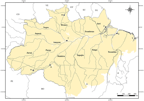
Distributional data was obtained from 128,387 examined specimens deposited in the following herpetological collections (museum acronyms in parenthesis): American Museum of Natural History, New York (AMNH), Faculdades Integradas do Tapajós, Santarém (LPHA), Instituto de Pesquisas Científicas e Tecnológicas do Estado do Amapá, Macapá (IEPA), Instituto Nacional de Pesquisas da Amazônia, Manaus (APL, INPA), Museu de Zoologia da Universidade de São Paulo, São Paulo (MZUSP), Museu Nacional do Rio de Janeiro, Rio de Janeiro (MNRJ), Museu Paraense Emílio Goeldi, Belém (MPEG), Museum of Comparative Zoology, Harvard University, Cambridge (MCZ), National Museum of Natural History, Smithsonian Institution, Washington D.C. (USNM), Universidade de Brasília, Brasília (CHUNB), and Universidade Estadual de Campinas, Campinas (ZUEC). The identification of all specimens was verified based on external morphology. All species included in the study had at least one record within the area defined as the Brazilian Amazonia (Figure ), and were direct examined by one of the authors (MAR-J). Four species (Anolis dissimilis, Bachia didactyla, B. scaea, and Rondonops xanthomystax) were included here based on records from the literature. Examined specimens are presented in Appendix 1. A South American vegetation map provided by Eva et al. [Citation32,33] was used to define the southern limits of the Brazilian Amazonia, which includes all patches of isolated savanna within the Amazonian forested matrix. The same delimitation has already been used in literature (see [Citation22,23]). As a spatial reference, the map of the Brazilian Amazonia (Figure ) shows the main tributaries of the Amazon River, Brazilian states, and their capital cities.
Figure 1. Map of the Brazilian Amazonia, with the main river basins, the Brazilian states which harbor the Amazonia, and the capital cities inside the Amazonia (in parenthesis). States and capitals cities: (1) Maranhão (São Luís); (2) Pará (Belém); (3) Amapá (Macapá); (4) Tocantins; (5) Mato Grosso; (6) Rondônia (Porto Velho); (7) Amazonas (Manaus); (8) Roraima (Boa Vista); (9) Acre (Rio Branco).
Geographical coordinates associated with the examined specimens were used when available, otherwise specimen locations were georeferenced based on collector’s field notes, personal information, or any other source that could identify the locality with confidence. In such cases, coordinates were identified with gazetteers (e.g. [Citation22]) and Google Earth [Citation34]. After searching every available gazetteer to identify the precise geographical position of a record, when specific localities could not be retrieved, the record was not considered for analysis. Records with incomplete information (e.g. Pará, Brazil) were still cited in Appendix 1 and used for distributional purposes.
Species occurrence, species richness, conservation analysis, and general patterns of species distribution
Species distribution models are increasingly proposed to support conservation decision-making.[Citation35] There are many possible approaches to modeling geographic distribution of a species in a comprehensive way, and in many cases the available data and/or predictors can be adequate for the intended objective.[Citation36] Whenever possible, knowledge about factors that influence the distribution of a target species should be used to improve the performance of the model, producing better results at the studied scale.[Citation37–39] Therefore, predictive modeling is proposed in this work as a reproducible and straightforward way to delineate present knowledge about lizard distribution verified from data collection. Species distribution models were constructed based on species occurrence records (based on examined specimens) and environmental layers. All species with at least five recorded points were modeled. Pearson et al. [Citation40] have already shown the potential of distribution models in extracting useful conservation and biogeographical information from small samples.
Initial modeling tests for species with restricted distribution within Amazonia resulted in extensive predicted areas, larger than those where the species actually occurred. Actual distributions were defined based on: (1) senior author expertise (MAR-J); (2) the species-locality database, constructed after visiting the 12 most important herpetological collections that harbor specimens from the study region (see Data Collection above); and (3) specific literature (see [Citation22,23]). In order to obtain accurate map predictions of species distribution, two different subsets of environmental variables were initially defined. For widespread species and species with a continuous distribution in the landscape, all climate and bioclimatic variables available in the Worldclim database (http://www.worldclim.org; and [Citation41]) were applied for distribution modeling. And, for species with restricted and/or fragmented distribution within Amazonia, as their distribution is limited to specific environments, another subset of variables were selected: geology,[Citation42] geomorphology,[Citation43] soil,[Citation44] vegetation,[Citation45] altitude,[Citation41] height above the nearest drainage (HAND),[Citation46] average precipitation in January (the coldest and wettest month) and July (the warmest and driest month), and minimum and maximum temperatures in January and July (both from Worldclim). All environmental variables were resampled to obtain grids with spatial resolutions of approximately 1 km. As recommended by Raes [Citation47], presence data from the complete distribution ranges (inside and outside the Brazilian Amazonia) of the species were used for both species groups.
Potential geographic distribution maps were generated using the Maximum Entropy algorithm,[Citation48] available at MaxEnt (version 3.3.3). This algorithm has been proved to be a robust method [Citation49–52] that performs better with limited sample size than alternative algorithms,[Citation40,53–55] and it is commonly applied to conservation-oriented studies.[Citation56,57] MaxEnt estimates, based on presence records, a multivariate distribution of suitable habitat conditions associated with species occurrence in the environmental feature-space (for more details, see [Citation48]). Two criteria enabled the modeling process for the identification of the set of environmental variables for each species that most contributed to the resulting model: (1) more than 10% of relative contribution to the model and (2) importance value (obtained through a Jackknife test), which reflects the degree of improvement of the model when the variable was added to it (Appendix 2). Maps of species occurrence were produced by applying binary thresholds over the resulting MaxEnt surfaces, adopting the ‘lowest presence threshold value’ (LPT), as suggested by Pearson et al. [Citation40]. In special cases, some additional editing was necessary to exclude distribution patches that were out of the known occurrence area of the species, or discontinuous to it (e.g. patches of occurrence in the Atlantic coastal region of species that occur only in Western Amazonia and the Andean region). These procedures allow the drawing, in a conservative way, of the extent of the species occurrence area, minimizing the risk of indicating its presence where it does not occur. Having an expert evaluation in this process is essential when the objective is to determine proper strategies for conservation.[Citation58,59]
In order to evaluate the situation of each species in terms of conservation within the Brazilian Amazonia, we calculated the percentage of their occurrence area within protected areas, and the percentage that has already been deforested. We considered three categories of protected areas: (a) strict nature reserves (SNR) (strictly protected areas; Unidades de Conservação de Proteção Integral, in the Brazilian legislation), where only indirect use of natural resources is permitted; (b) managed resource protected areas (MRPA) (conservation units of sustainable use; Unidades de Conservação de Uso Sustentável, in Brazilian legislation), where a variety of land uses and natural resource exploitation are allowed;[Citation60] (c) and indigenous peoples’ territories and protected areas (IPT) (indigenous lands; Terras Indígenas, in Brazilian legislation), which occupy an area five times larger than SNR that, although not primarily aimed at the preservation of the environment, play an important role in this aspect.[Citation61–65] Both federal and state protected areas were considered, whose limits were obtained from [Citation66]. Deforestation data of the Brazilian Amazonia was obtained from [Citation67]. Similar analyses were done for a map on species richness, obtained through compiling all species occurrence maps, overlapping them, and generating a map where the number of species per pixel is depicted. The detection of the patterns of species richness can contribute to prioritizing locations for biodiversity conservation, and have to be used with additional metrics, such as species endemism and the severity of threats.[Citation68] Networks of protected areas designated to protect centers of richness also tend to encompass a high proportion of geographically restricted species.[Citation69] The general patterns of species distribution were established, which summarizes the occurrence maps produced, and were defined based on distribution of each species. We used the same parameters used by Ávila-Pires [Citation8], with some adaptations: the Amazon River delimited the southern and northern distributions; the Negro and Madeira river systems delimited the eastern distributions; the Negro and Tapajós river systems delimited the western distributions; the general northern and southern patterns subdivided according to the species occurrence area inside these regions. We used ArcGIS [Citation70] for all geoprocessing analyses described above. Occurrence layers of each analysed species are available as supplemental online material.
Conservation status
Reptile species are poorly represented on the IUCN Red List of Threatened Species, limiting our understanding of threats to the group.[Citation71] For the purposes of regional conservation assessments, there are important reasons to assess species’ extinction risk and publish Red Lists within specific geographically defined areas.[Citation72] For the Brazilian Amazonia, we evaluated all lizard species based on published data [Citation22,23] and our own unpublished information on species distribution. We followed IUCN guidelines at a regional level.[Citation72] The IUCN criteria were also used to categorize the conservation status of Brazilian species.[Citation73] Based on a preliminary screening of the available information (distribution, abundance, ecology, population trends, habitat preferences), and our findings regarding the threats to each species, we classified the status of each species following the IUCN categorization rules,[Citation72] where species are classified as Critically Endangered (CR), Endangered (EN), Vulnerable (VU), Near Threatened (NT), Data Deficient (DD), Least Concern (LC), or Not Applicable (NA). For endemic species, we compared our results with the Brazilian Red List of Threatened Species,[Citation73] the Red List of Threatened Species in Pará state,[Citation74] and the IUCN Red List.[Citation75] For species without a previously assigned category, we assign one.
Data on individual taxa
Families, genera, and species are described in alphabetical order. When subspecies are recognized in the literature and they constitute distinguishable taxa, we present them separately. For each recognized taxon we present: (1) its distribution (data from the examined specimens – in Appendix 1 – complemented by the literature [Citation22,23]); (2) the extent of occurrence in the Brazilian Amazonia; (3) the percentage of the occurrence area under protected areas, and the percentage of the occurrence area that has been deforested; (4) the main threats (or potential threats) in the Brazilian Amazonia, considering species occurrence area and ecological aspects (data from literature, and personal observations); (5) the conservation status, proposed herein for endemic species, or for the populations of the non-endemic species that are distributed in the Brazilian Amazonia (or breeding population; see [Citation72]); and (6) a map of occurrence area in the Brazilian Amazonia, including the species records, and its overlap with protected and deforested areas, according to MMA [Citation66] and INPE [Citation67], respectively (see above).
Results
Diversity, distribution, occurrence area, and conservation status
We recorded 138 species-level taxa of lizards from the Brazilian Amazonia, arranged in 51 genera and 13 families (Table ). Gymnophthalmidae presents the largest number of species-level taxa (n = 52), followed by Teiidae (n = 19), Dactyloidae, and Tropiduridae (n = 16 for each one). Eleven of the recognized taxa are not yet described: four in Cercosaura (under revision), three in Cnemidophorus (under description), one in Tupinambis (under description), one in Gymnophthalmus (already mentioned in [Citation76,77]), one in Leposoma (already mentioned in [Citation13,78]), and one in Plica (under revision). Of the 138 recognized taxa, eight presented less than five records and were therefore not considered for analysis (Anolis dissimilis, Bachia didactyla, B. remota, B. scaea, Marinussaurus curupira, Pseudogonatodes gasconi, Cnemidophorus sp. 2, and Cnemidophorus sp. 3). Hemidactylus mabouia (a species introduced to South America, found only in perianthropic situations in Amazonia; see [Citation23]) was also not considered for analyzes. Each taxon is presented below.
Table 1. Lizard species-level taxa present in the Brazilian Amazonia.
Anguidae
Diploglossus Wiegmann.[Citation79]
Diploglossus fasciatus (Gray).[Citation80]
Distribution. Brazil, Peru, and Bolivia.
Extent of occurrence. 121,822.02 km2.
Occurrence area. In the Brazilian Amazonia Diploglossus angulatus has about 39% of its occurrence area inside protected areas, and about 17% of its occurrence area has been deforested (Figure ).
Figure 2. Occurrence area and records of Diploglossus fasciatus in the Brazilian Amazonia, showing the overlap with protected and deforested areas.
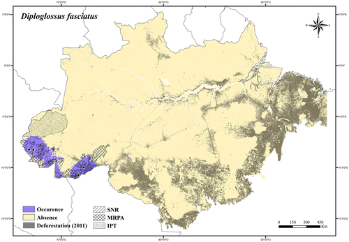
Regional threats. Deforestation of Bamboo forests; expansion of roads and urban areas.
Conservation status. LC (Least Concern).
Dactyloidae
Anolis Daudin.[Citation81]
Anolis auratus Daudin.[Citation81]
Distribution. Panama, Nicaragua, Brazil, French Guiana, Suriname, Guyana, Venezuela, and Colombia.
Extent of occurrence. 55,133.87 km2.
Occurrence area. In the Brazilian Amazonia Anolis auratus has about 25% of its occurrence area inside protected areas, and at least 13% of its occurrence area has been deforested (Figure ).
Figure 3. Occurrence area and records of Anolis auratus in the Brazilian Amazonia, showing the overlap with protected and deforested areas.
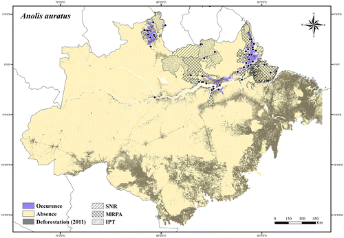
Regional threats. Conversion and degradation of savanna enclaves along the Amazon River and Atlantic coastal region, through expansion of electricity transmission lines, roads and urban areas; rapid agricultural expansion, clearing for pasture, and fires in the Lavrado region of Roraima state.
Conservation status. LC (Least Concern).
Anolis bombiceps Cope.[Citation82]
Distribution. Brazil, Colombia, Ecuador, and Peru.
Extent of occurrence. 150,012.26 km2.
Occurrence area. In the Brazilian Amazonia Anolis bombiceps has about 80% of its occurrence area inside protected areas, and less than 1% of its occurrence area has been deforested (Figure ).
Figure 4. Occurrence area and records of Anolis bombiceps in the Brazilian Amazonia, showing the overlap with protected and deforested areas.
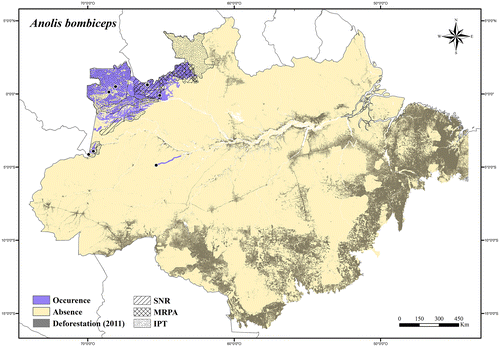
Regional threats. No current or potential threats in its occurrence area.
Conservation status. LC (Least Concern).
Anolis brasiliensis Vanzolini & Williams.[Citation83]
Distribution. Endemic to Brazil.
Extent of occurrence. 240,868.38 km2.
Occurrence area. In the Brazilian Amazonia Anolis brasiliensis has about 20% of its occurrence area inside protected areas, and at least 53% of its occurrence area has been deforested (Figure ).
Figure 5. Occurrence area and records of Anolis brasiliensis in the Brazilian Amazonia, showing the overlap with protected and deforested areas.
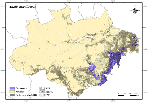
Regional threats. Rapid agricultural expansions (mainly soybean production), roads expansion, clearing for pasture, and fires.
Conservation status. NT (Near Threatened); it was listed in the Red List of Threatened Species of the Pará state,[Citation74] Brazil.
Anolis chrysolepis Duméril & Bibron.[Citation84]
Distribution. Brazil, French Guiana, Suriname, Guyana, and Venezuela.
Extent of occurrence. 242,822.42 km2.
Occurrence area. In the Brazilian Amazonia Anolis chrysolepis has about 76% of its occurrence area inside protected areas, and about 2% of its occurrence area has been deforested (Figure ).
Figure 6. Occurrence area and records of Anolis chrysolepis in the Brazilian Amazonia, showing the overlap with protected and deforested areas.
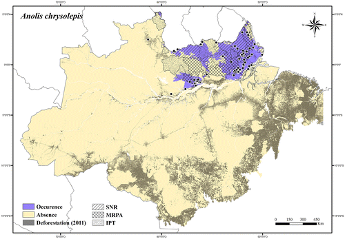
Regional threats. Expansion of electricity transmission lines, roads and urban areas along Amazon River and Atlantic coastal region; construction and operation of hydroelectric dams, and infrastructure associated with power stations on the Trombetas River.
Conservation status. LC (Least Concern).
Anolis dissimilis Williams.[Citation85]
Distribution. Brazil and Peru.
Extent of occurrence. Not analyzed.
Occurrence area. In the Brazilian Amazonia it is only known from two localities, Manuel Urbano and Senador Guiomard, both in Acre state (see [Citation86,87]).
Regional threats. Deforestation of Bamboo forests, and expansion of roads and urban areas.
Conservation status. LC (Least Concern).
Anolis fuscoauratus d’Orbigny.[Citation88]
Distribution. Panama, Brazil, French Guiana, Suriname, Guyana, Venezuela, Colombia, Ecuador, Peru, and Bolivia.
Extent of occurrence. 3,679,963.53 km2.
Occurrence area. In the Brazilian Amazonia Anolis fuscoauratus has about 52% of its occurrence area inside protected areas, and about 14% of its occurrence area has been deforested (Figure ).
Figure 7. Occurrence area and records of Anolis fuscoauratus in the Brazilian Amazonia, showing the overlap with protected and deforested areas.
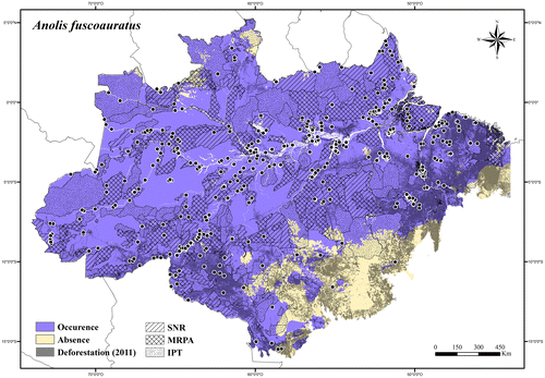
Regional threats. Deforestation (widespread species).
Conservation status. LC (Least Concern).
Anolis meridionalis Boettger.[Citation89]
Distribution. Brazil and Bolivia.
Extent of occurrence. 193,303.41 km2.
Occurrence area. In the Brazilian Amazonia Anolis meridionalis has about 17% of its occurrence area inside protected areas, and at least 42% of its occurrence area has been deforested (Figure ).
Figure 8. Occurrence area and records of Anolis meridionalis in the Brazilian Amazonia, showing the overlap with protected and deforested areas.
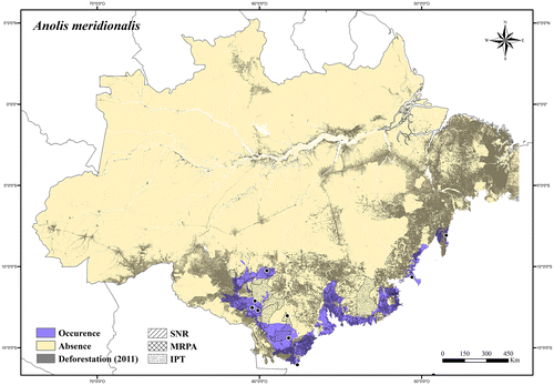
Regional threats. Rapid agricultural expansions (mainly soybean production), roads expansion, clearing for pasture, and fires.
Conservation status. NT (Near Threatened).
Anolis ortonii Cope.[Citation90]
Distribution. Brazil, French Guiana, Suriname, Guyana, Venezuela, Colombia, Ecuador, Peru, and Bolivia.
Extent of occurrence. 2,586,763.43 km2.
Occurrence area. In the Brazilian Amazonia Anolis ortonii has about 50% of its occurrence area inside protected areas, and about 13% of its occurrence area has been deforested (Figure ).
Figure 9. Occurrence area and records of Anolis ortonii in the Brazilian Amazonia, showing the overlap with protected and deforested areas.
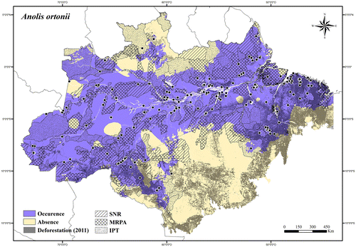
Regional threats. Deforestation (widespread species).
Conservation status. LC (Least Concern).
Anolis philopunctatus Rodrigues.[Citation91]
Distribution. Endemic to the Negro–Trombetas Interfluvium, in the Brazilian Amazonia.
Extent of occurrence. 42,164.74 km2.
Occurrence area. Anolis philopunctatus has about 48% of its occurrence area inside protected areas, and about 7% of its occurrence area has been deforested (Figure ).
Figure 10. Occurrence area and records of Anolis philopunctatus, showing the overlap with protected and deforested areas.
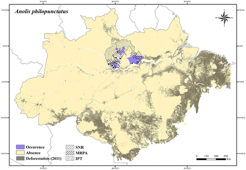
Regional threats. Expansion of urban areas (Manaus metropolitan area); expansion of electricity transmission lines along the Amazon River; construction and operation of hydroelectric dams, and infrastructure associated with power stations on the Trombetas River.
Conservation status. LC (Least Concern).
Anolis phyllorhinus Myers & Carvalho.[Citation92]
Distribution. Endemic to the Madeira–Tapajós Interfluvium, in the Brazilian Amazonia.
Extent of occurrence. 46,092.57 km2.
Occurrence area: Anolis phyllorhinus has about 40% of its occurrence area inside protected areas, and about 8% of its occurrence area has been deforested (Figure ).
Figure 11. Occurrence area and records of Anolis phyllorhinus, showing the overlap with protected and deforested areas.
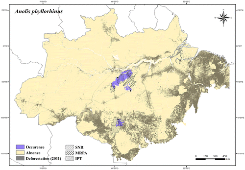
Regional threats: Rapid agricultural expansions (mainly soybean production), roads expansion, clearing for pasture, and fires in its southern occurrence area.
Conservation status: LC (Least Concern).
Anolis planiceps Troschel.[Citation93]
Distribution. Trinidad and Tobago, Brazil, Guyana, Venezuela, and Colombia.
Extent of occurrence. 386,573.32 km2.
Occurrence area. In the Brazilian Amazonia Anolis planiceps has about 56% of its occurrence area inside protected areas, and about 3% of its occurrence area has been deforested (Figure ).
Figure 12. Occurrence area and records of Anolis planiceps in the Brazilian Amazonia, showing the overlap with protected and deforested areas.
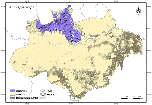
Regional threats. Expansion of urban areas (Manaus metropolitan area) and roads; rapid agricultural expansion, clearing for pasture, and fires in the Lavrado region of Roraima state.
Conservation status. LC (Least Concern).
Anolis punctatus Daudin.[Citation81]
Distribution. Brazil, French Guiana, Suriname, Guyana, Venezuela, Colombia, Ecuador, Peru, and Bolivia.
Extent of occurrence. 3,202,372.66 km2.
Occurrence area. In the Brazilian Amazonia Anolis punctatus has about 50% of its occurrence area inside protected areas, and about 14% of its occurrence area has been deforested (Figure ).
Figure 13. Occurrence area and records of Anolis punctatus in the Brazilian Amazonia, showing the overlap with protected and deforested areas.
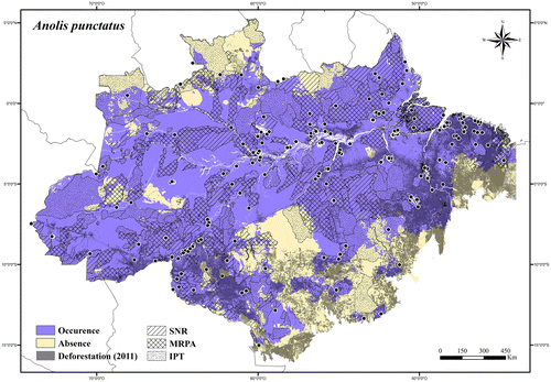
Regional threats. Deforestation (widespread species).
Conservation status. LC (Least Concern).
Anolis scypheus Cope.[Citation94]
Distribution. Brazil, Colombia, Ecuador, and Peru.
Extent of occurrence. 36,803.12 km2.
Occurrence area. In the Brazilian Amazonia Anolis scypheus has about 52% of its occurrence area inside protected areas, and less than 0.2% of its occurrence area has been deforested (Figure ).
Figure 14. Occurrence area and records of Anolis scypheus in the Brazilian Amazonia, showing the overlap with protected and deforested areas.
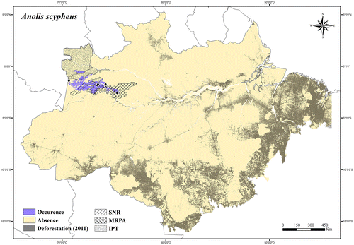
Regional threats. No current or potential threats in its occurrence area.
Conservation status. LC (Least Concern).
Anolis tandai Ávila-Pires.[Citation8]
Distribution. Brazil and Peru.
Extent of occurrence. 1,265,845.26 km2.
Occurrence area. In the Brazilian Amazonia Anolis tandai has about 48% of its occurrence area inside protected areas, and about 5% of its occurrence area has been deforested (Figure ).
Figure 15. Occurrence area and records of Anolis tandai in the Brazilian Amazonia, showing the overlap with protected and deforested areas.
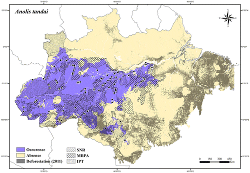
Regional threats. Rapid agricultural expansions (mainly soybean production), roads expansion, clearing for pasture, and fires in its southern occurrence area and along the Tapajós River; construction and operation of hydroelectric dams, and infrastructure associated with power stations on the Tapajós River; expansion of agricultural fields (soybean production), roads, and urban areas along the Madeira River.
Conservation status. LC (Least Concern).
Anolis trachyderma Cope.[Citation82]
Distribution. Brazil, Colombia, Ecuador, and Peru.
Extent of occurrence. 454,029 km2.
Occurrence area. In the Brazilian Amazonia Anolis trachyderma has about 58% of its occurrence area inside protected areas, and about 8% of its occurrence area has been deforested (Figure ).
Figure 16. Occurrence area and records of Anolis trachyderma in the Brazilian Amazonia, showing the overlap with protected and deforested areas.
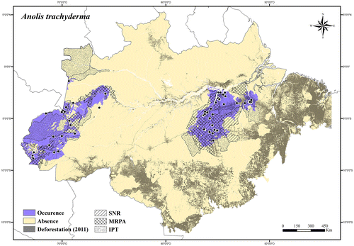
Regional threats. Roads expansion, clearing for pasture, and fires in its eastern occurrence area; construction and operation of hydroelectric dams, and infrastructure associated with power stations on the Tapajós and Xingu rivers.
Conservation status. LC (Least Concern).
Anolis transversalis Duméril.[Citation95]
Distribution. Brazil, Colombia, Ecuador, Peru, and Bolivia.
Extent of occurrence. 1,289,565.9 km2.
Occurrence area. In the Brazilian Amazonia Anolis transversalis has about 49% of its occurrence area inside protected areas, and about 7% of its occurrence area has been deforested (Figure ).
Figure 17. Occurrence area and records of Anolis transversalis in the Brazilian Amazonia, showing the overlap with protected and deforested areas.
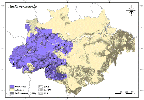
Regional threats. Rapid agricultural expansions (mainly soybean production), expansion of roads and urban areas, clearing for pasture, and fires in its southern occurrence area and along the Madeira River; construction and operation of hydroelectric dams, and infrastructure associated with power stations on the Madeira River.
Conservation status. LC (Least Concern).
Gekkonidae
Hemidactylus Oken.[Citation96]
Hemidactylus mabouia (Moreau de Jonnés).[Citation97]
Distribution. All countries of the continent.
Extent of occurrence. Not analyzed.
Occurrence area. In the Brazilian Amazonia Hemidactylus mabouia is found only in perianthropic situations (see [Citation23]).
Regional threats. Not relevant (introduced species; inhabits perianthropic situations).
Conservation status: NA (Not Applicable).
Hemidactylus palaichthus Kluge.[Citation98]
Distribution. Brazil, Suriname, Guyana, Venezuela, Colombia, Trinidad and Tobago, and Sta. Lucia Island.
Extent of occurrence. 44,686.28 km2.
Occurrence area. In the Brazilian Amazonia Hemidactylus palaichthus has about 33% of its occurrence area inside protected areas, and about 9% of its occurrence area has been degraded (Figure ).
Figure 18. Occurrence area and records of Hemidactylus palaichthus in the Brazilian Amazonia, showing the overlap with protected and deforested areas.
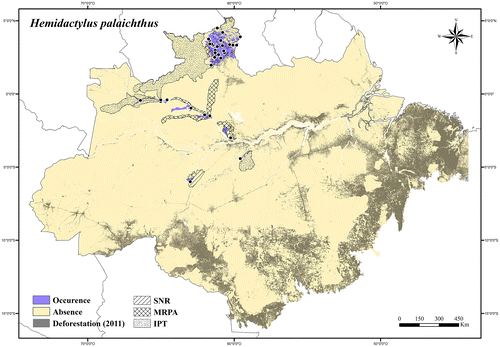
Regional threats. Rapid agricultural expansions, clearing for pasture, and fires in the Lavrado region of Roraima state.
Conservation status. LC (Least Concern); it was listed in the IUCN Red List [Citation75] as LC.
Gymnophthalmidae
Alopoglossus Boulenger.[Citation99]
Alopoglossus angulatus (Linnaeus).[Citation100]
Distribution. Brazil, French Guiana, Suriname, Guyana, Colombia, Ecuador, Peru, and Bolivia.
Extent of occurrence. 1,301,801.88 km2.
Occurrence area. In the Brazilian Amazonia Alopoglossus angulatus has about 48% of its occurrence area inside protected areas, and about 14% of its occurrence area has been deforested (Figure ).
Figure 19. Occurrence area and records of Alopoglossus angulatus in the Brazilian Amazonia, showing the overlap with protected and deforested areas.
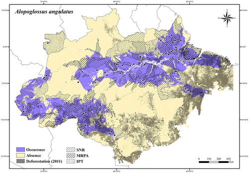
Regional threats. Deforestation (widespread species).
Conservation status. LC (Least Concern); it was listed in the IUCN Red List [Citation75] as LC.
Alopoglossus atriventris Duellman.[Citation101]
Distribution. Brazil, Colombia, Ecuador, and Peru.
Extent of occurrence. 935,081.48 km2.
Occurrence area. In the Brazilian Amazonia Alopoglossus atriventris has about 48% of its occurrence area inside protected areas, and about 2% of its occurrence area has been deforested (Figure ).
Figure 20. Occurrence area and records of Alopoglossus atriventris in the Brazilian Amazonia, showing the overlap with protected and deforested areas.
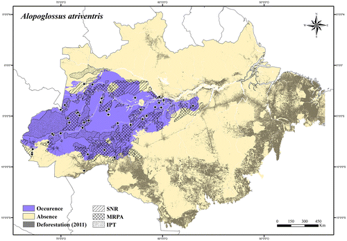
Regional threats. Rapid agricultural expansions (mainly soybean production), and expansion of roads and urban areas in its southern occurrence area and along the Madeira River.
Conservation status. LC (Least Concern).
Amapasaurus Cunha.[Citation102]
Amapasaurus tetradactylus Cunha.[Citation102]
Distribution. Brazil and French Guiana.
Extent of occurrence. 68,216.34 km2.
Occurrence area. In the Brazilian Amazonia Amapasaurus tetradactylus has about 91% of its occurrence area inside protected areas, and less than 0.5% of its occurrence area has been deforested (Figure ).
Figure 21. Occurrence area and records of Amapasaurus tetradactylus in the Brazilian Amazonia, showing the overlap with protected and deforested areas.
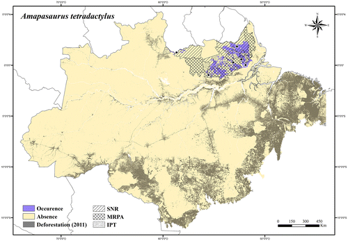
Regional threats. No current or potential threats in its occurrence area.
Conservation status. LC (Least Concern); it was listed in the IUCN Red List [Citation75] as DD (Data Deficient).
Arthrosaura Boulenger.[Citation99]
Arthrosaura kockii (Lidth de Jeude).[Citation103]
Distribution. Brazil, French Guiana, and Suriname.
Extent of occurrence. 474,846.07 km2.
Occurrence area. In the Brazilian Amazonia Arthrosaura kockii has about 48% of its occurrence area inside protected areas, and about 26% of its occurrence area has been deforested (Figure ).
Figure 22. Occurrence area and records of Arthrosaura kockii in the Brazilian Amazonia, showing the overlap with protected and deforested areas.
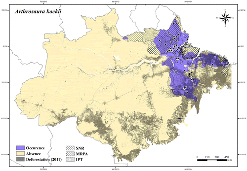
Regional threats. Expansion of roads and urban areas, clearing for pasture, and fires in its southern occurrence area; expansion of electricity transmission lines, roads, and urban areas along the north side of the Amazon River and Atlantic coastal region.
Conservation status. LC (Least Concern); it was listed in the IUCN Red List [Citation75] as LC.
Arthrosaura reticulata (O’Shaughnessy).[Citation104]
Distribution. Brazil, Suriname, Guyana, Venezuela, Colombia, Ecuador, and Peru.
Extent of occurrence. 2,978,016.67 km2.
Occurrence area. In the Brazilian Amazonia Arthrosaura reticulata has about 54% of its occurrence area inside protected areas, and about 11% of its occurrence area has been deforested (Figure ).
Figure 23. Occurrence area and records of Arthrosaura reticulata in the Brazilian Amazonia, showing the overlap with protected and deforested areas.
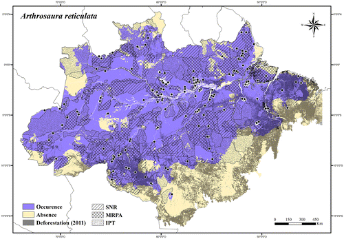
Regional threats. Deforestation (widespread species).
Conservation status. LC (Least Concern).
Bachia Gray.[Citation105]
Bachia didactyla Freitas et al. [Citation106]
Distribution. Endemic to Southern Brazilian Amazonia.
Extent of occurrence. Not analyzed.
Occurrence area. It is only known from two localities, both in enclaves of open vegetation in Sapezal (Mato Grosso state) and Vilhena (Rondônia state) (see [Citation106]).
Regional threats. Rapid agricultural expansions (mainly soybean production), expansion of roads and urban areas, clearings for pasture, and fires.
Conservation status. EN (Endangered) B1ab(iii); it was listed in the Brazilian Red List of Threatened Species [Citation73] as EN B1ab(iii).
Bachia dorbignyi (Duméril & Bibron).[Citation107]
Distribution. Brazil, Peru, and Bolivia.
Extent of occurrence. 101,222.15 km2.
Occurrence area. In the Brazilian Amazonia Bachia dorbignyi has about 52% of its occurrence area inside protected areas, and about 24% of its occurrence area has been deforested (Figure ).
Figure 24. Occurrence area and records of Bachia dorbignyi in the Brazilian Amazonia, showing the overlap with protected and deforested areas.
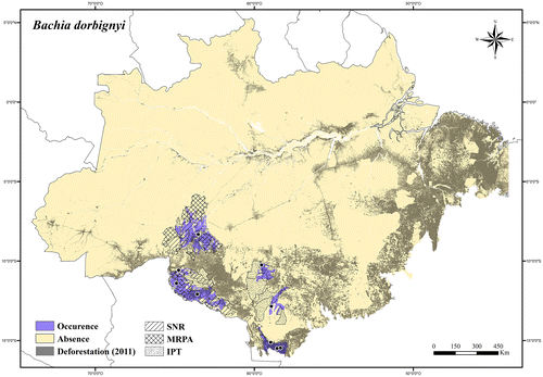
Regional threats. Rapid agricultural expansions, expansion of roads and urban areas, clearing for pasture, and fires; construction and operation of hydroelectric dams, and infrastructure associated with power stations on the Madeira River.
Conservation status. LC (Least Concern).
Bachia flavescens (Bonnaterre).[Citation108]
Distribution. Brazil, French Guiana, Suriname, Guyana, and Venezuela.
Extent of occurrence. 788,813.33 km2.
Occurrence area. In the Brazilian Amazonia Bachia flavescens has about 56% of its occurrence area inside protected areas, and about 13% of its occurrence area has been deforested (Figure ).
Figure 25. Occurrence area and records of Bachia flavescens in the Brazilian Amazonia, showing the overlap with protected and deforested areas.
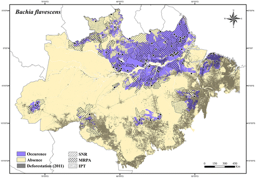
Regional threats. Rapid agricultural expansions (mainly soybean production), expansion of roads and urban areas, clearing for pasture, and fires in its southern occurrence area; expansion of electricity transmission lines, roads, and urban areas along the north side of the Amazon River and Atlantic coastal region; rapid agricultural expansions, clearing for pasture, and fires in the Lavrado region of Roraima state.
Conservation status. LC (Least Concern); it was listed in the IUCN Red List [Citation75] as LC.
Bachia panoplia Thomas.[Citation109]
Distribution. Endemic to the Negro–Trombetas Interfluvium, and lower Tapajós River, in the Brazilian Amazonia.
Extent of occurrence. 24,699.41 km2.
Occurrence area. Bachia panoplia has about 32% of its occurrence area inside protected areas, and about 13% of its occurrence area has been deforested (Figure ).
Figure 26. Occurrence area and records of Bachia panoplia in the Brazilian Amazonia, showing the overlap with protected and deforested areas.
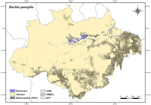
Regional threats. Expansion of urban areas (Manaus metropotian area and Santarém municipality) and roads; expansion of electricity transmission lines along the Amazon River; construction and operation of hydroelectric dams, and infrastructure associated with power stations on the Trombetas River.
Conservation status. LC (Least Concern); it was listed in the IUCN Red List [Citation75] as LC.
Bachia peruana (Werner).[Citation110]
Distribution. Brazil and Peru.
Extent of occurrence. 48,898.28 km2.
Occurrence area. In the Brazilian Amazonia Bachia peruana has about 52% of its occurrence area inside protected areas, and about 5% of its occurrence area has been deforested (Figure ).
Figure 27. Occurrence area and records of Bachia peruana in the Brazilian Amazonia, showing the overlap with protected and deforested areas.
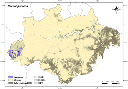
Regional threats. No current or potential threats in its occurrence area.
Conservation status. LC (Least Concern).
Bachia pyburni Kizirian & McDiarmid.[Citation111]
Distribution. Brazil, Venezuela, and Colombia.
Extent of occurrence. 1201.97 km2.
Occurrence area. In the Brazilian Amazonia Bachia pyburni has 100% of its occurrence area inside protected areas, and less than 0.1% of its occurrence area has been deforested (Figure ).
Figure 28. Occurrence area and records of Bachia pyburni in the Brazilian Amazonia, showing the overlap with protected and deforested areas.
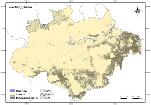
Regional threats. No current or potential threats in its occurrence area.
Conservation status. LC (Least Concern).
Bachia remota Ribeiro-Júnior et al. [Citation112]
Distribution. Endemic to Northeastern Brazilian Amazonia (Appendix 1).
Extent of occurrence. Not analyzed.
Occurrence area. It is only knonw from one locality in the Montanhas do Tumucumaque National Park, Laranjal do Jari, Amapá state (see [Citation112]).
Regional threats. No current or potential threats in its occurrence area.
Conservation status. LC (Least Concern).
Bachia scaea Teixeira et al. [Citation113]
Distribution. Endemic to Southern Brazilian Amazonia.
Extent of occurrence. Not analyzed.
Occurrence area. It is only known from the left bank of the Madeira River, in Porto Velho, Rondônia state (see [Citation113]).
Regional threats. Construction and operation of hydroelectric dams, and infrastructure associated with power stations on the Madeira River.
Conservation status. DD (Data Deficient).
Bachia scolecoides Vanzolini.[Citation114]
Distribution. Endemic to the Madeira–Xingu Interfluvium, in the Brazilian Amazonia.
Extent of occurrence. 203,120.28 km2.
Occurrence area. Bachia scolecoides has about 34% of its occurrence area inside protected areas, and about 21% of its occurrence area has been deforested (Figure ).
Figure 29. Occurrence area and records of Bachia scolecoides in the Brazilian Amazonia, showing the overlap with protected and deforested areas.
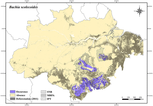
Regional threats. Rapid agricultural expansions (mainly soybean production), expansion of roads and urban areas, clearing for pasture, and fires.
Conservation status. LC (Least Concern).
Cercosaura Wagler.[Citation115]
Cercosaura argulus Peters.[Citation116]
Distribution. Brazil, Suriname, Guyana, Colombia, Ecuador, Peru, and Bolívia.
Extent of occurrence. 1,926,782.99 km2.
Occurrence area. In the Brazilian Amazonia Cercosaura argulus has about 50% of its occurrence area inside protected areas, and about 13% of its occurrence area has been deforested (Figure ).
Figure 30. Occurrence area and records of Cercosaura argulus in the Brazilian Amazonia, showing the overlap with protected and deforested areas.
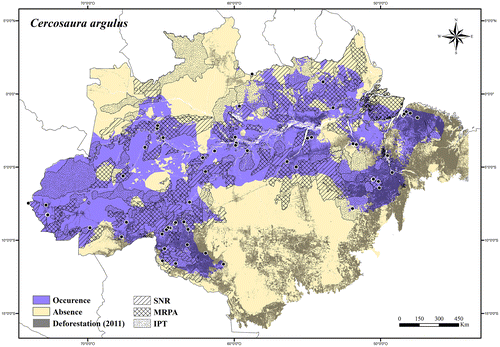
Regional threats. Deforestation (widespread species).
Conservation status. LC (Least Concern); it was listed in the IUCN Red List [Citation75] as LC.
Cercosaura eigenmanni (Griffin).[Citation117]
Distribution. Brazil, Peru, and Bolivia
Extent of occurrence. 353,116.78 km2.
Occurrence area. In the Brazilian Amazonia Cercosaura eigenmanni has about 42% of its occurrence area inside protected areas, and about 28% of its occurrence area has been deforested (Figure ).
Figure 31. Occurrence area and records of Cercosaura eigenmanni in the Brazilian Amazonia, showing the overlap with protected and deforested areas.
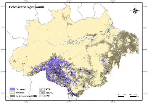
Regional threats. Rapid agricultural expansions (mainly soybean production), expansion of roads and urban areas, clearing for pasture, and fires; construction and operation of hydroelectric dams, and infrastructure associated with power stations on the Madeira River.
Conservation status. LC (Least Concern).
Cercosaura ocellata Wagler.[Citation115]
Cercosaura ocellata ocellata Wagler.[Citation115]
Distribution. Brazil, French Guiana, Suriname, Guyana, and Venezuela.
Extent of occurrence. 915,629.5 km2.
Occurrence area. In the Brazilian Amazonia Cercosaura ocellata ocellata has about 51% of its occurrence area inside protected areas, and about 18% of its occurrence area has been deforested (Figure ).
Figure 32. Occurrence area and records of Cercosaura ocellata ocellata in the Brazilian Amazonia, showing the overlap with protected and deforested areas.
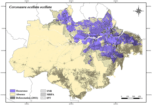
Regional threats. Expansion of roads and urban areas, clearing for pasture, and fires in its southern occurrence area; expansion of electricity transmission lines, roads, and urban areas along the north side of the Amazon River and Atlantic coastal region; rapid agricultural expansions, clearing for pasture, and fires in the Lavrado region of Roraima state.
Conservation status. LC (Least Concern).
Cercosaura ocellata bassleri Ruibal.[Citation118]
Distribution. Brazil, Colombia, Peru, and Bolivia.
Extent of occurrence. 1,049,856.58 km2.
Occurrence area. In the Brazilian Amazonia Cercosaura ocellata bassleri has about 48% of its occurrence area inside protected areas, and about 4% of its occurrence area has been deforested (Figure ).
Figure 33. Occurrence area and records of Cercosaura ocellata bassleri in the Brazilian Amazonia, showing the overlap with protected and deforested areas.
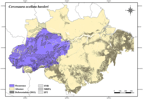
Regional threats. Rapid agricultural expansions (mainly soybean production), expansion of roads and urban areas along the Madeira River.
Conservation status. LC (Least Concern).
Cercosaura ocellata ssp.
Distribution. Brazil and Paraguay.
Extent of occurrence. 92,021.15 km2.
Occurrence area. In the Brazilian Amazonia Cercosaura ocellata ssp. has about 15% of its occurrence area inside protected areas, and about 44% of its occurrence area has been deforested (Figure ).
Figure 34. Occurrence area and records of Cercosaura ocellata ssp. in the Brazilian Amazonia, showing the overlap with protected and deforested areas.
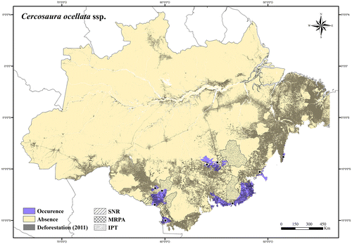
Regional threats. Rapid agricultural expansions (mainly soybean production), roads expansion, clearing for pasture, and fires.
Conservation status. NT (Near Threatened).
Cercosaura oshaughnessyi (Boulenger).[Citation99]
Distribution. Brazil, Colombia, Ecuador, and Peru.
Extent of occurrence. 397,102.5 km2.
Occurrence area. In the Brazilian Amazonia Cercosaura oshaughnessyi has about 56% of its occurrence area inside protected areas, and about 6% of its occurrence area has been deforested (Figure ).
Figure 35. Occurrence area and records of Cercosaura oshaughnessyi in the Brazilian Amazonia, showing the overlap with protected and deforested areas.
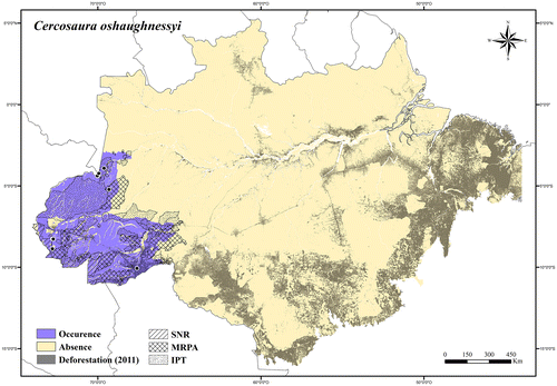
Regional threats. Expansion of roads and urban areas in its southeastern occurrence area.
Conservation status. LC (Least Concern).
Cercosaura parkeri (Ruibal).[Citation118]
Distribution. Brazil, Peru, Bolivia, and Argentina.
Extent of occurrence. 237,248.75 km2.
Occurrence area. In the Brazilian Amazonia Cercosaura parkeri has about 51% of its occurrence area inside protected areas, and about 22% of its occurrence area has been deforested (Figure ).
Figure 36. Occurrence area and records of Cercosaura parkeri in the Brazilian Amazonia, showing the overlap with protected and deforested areas.
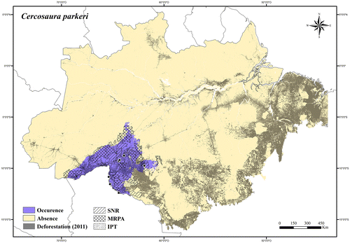
Regional threats. Rapid agricultural expansions (mainly soybean production), expansion of roads and urban areas, clearing for pasture, and fires; construction and operation of hydroelectric dams, and infrastructure associated with power stations on the Madeira River.
Conservation status. LC (Least Concern).
Cercosaura schreibersii Wiegmann.[Citation79]
Distribution. Brazil, Bolivia, Argentina, Paraguay, and Uruguay.
Extent of occurrence. 143,633.29 km2.
Occurrence area. In the Brazilian Amazonia Cercosaura schreibersii has about 16% of its occurrence area inside protected areas, and about 45% of its occurrence area has been deforested (Figure ).
Figure 37. Occurrence area and records of Cercosaura schreibersii in the Brazilian Amazonia, showing the overlap with protected and deforested areas.
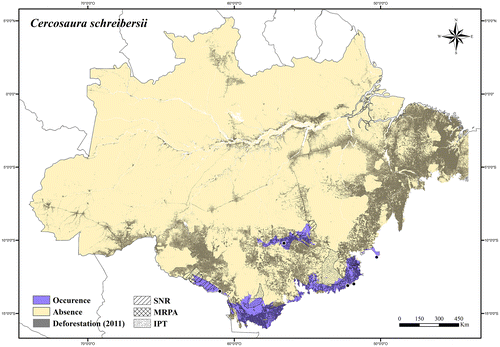
Regional threats. Rapid agricultural expansions (mainly soybean production), roads expansion, clearing for pasture, and fires.
Conservation status. NT (Near Threatened); it was listed in the IUCN Red List [Citation75] as LC.
Cercosaura sp. 1
Distribution. Endemic to Southern Brazilian Amazonia.
Extent of occurrence. 739,422.23 km2.
Occurrence area. Cercosaura sp. 1 has about 48% of its occurrence area inside protected areas, and about 14% of its occurrence area has been deforested (Figure ).
Figure 38. Occurrence area and records of Cercosaura sp. 1, showing the overlap with protected and deforested areas.
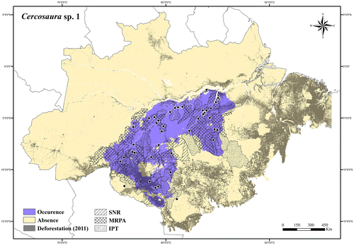
Regional threats. Rapid agricultural expansions (mainly soybean production), roads expansion, clearing for pasture, and fires in its southern occurrence area and along the Tapajós River; construction and operation of hydroelectric dams, and infrastructure associated with power stations on the Tapajós and Jamanxin rivers; expansion of agricultural fields (soybean production), roads, and urban areas along the Madeira River.
Conservation status. LC (Least Concern).
Cercosaura sp. 2
Distribution. Endemic to Jamanxim river system, in the Brazilian Amazonia.
Extent of occurrence. 24,218.62 km2.
Occurrence area. Cercosaura sp. 2 has about 74% of its occurrence area inside protected areas, and about 8% of its occurrence area has been deforested (Figure ).
Figure 39. Occurrence area and records of Cercosaura sp. 2, showing the overlap with protected and deforested areas.
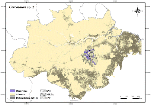
Regional threats. Expansion of roads and urban areas, clearing for pasture, and fires; construction and operation of hydroelectric dams, and infrastructure associated with power stations on the Tapajós and Jamanxin rivers.
Conservation status. LC (Least Concern).
Cercosaura sp. 3
Distribution. Brazil and French Guiana.
Extent of occurrence. 60,441.38 km2.
Occurrence area. In the Brazilian Amazonia Cercosaura sp. 3 has about 90% of its occurrence area inside protected areas, and about 1% of its occurrence area has been deforested (Figure ).
Figure 40. Occurrence area and records of Cercosaura sp. 3, showing the overlap with protected and deforested areas.
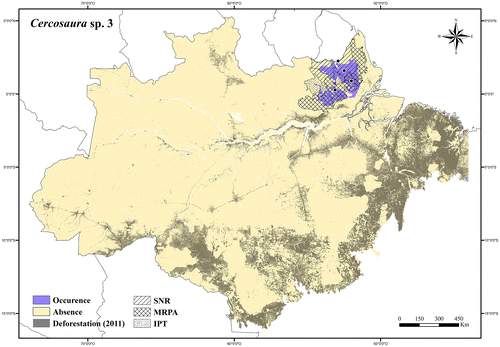
Regional threats. No current or potential threats in its occurrence area.
Conservation status. LC (Least Concern).
Colobosaura Boulenger.[Citation119]
Colobosaura modesta (Reinhardt & Lütken).[Citation120]
Distribution. Brazil and Paraguay.
Extent of occurrence. 113,894.23 km2.
Occurrence area. In the Brazilian Amazonia Colobosaura modesta has about 7% of its occurrence area inside protected areas, and about 63% of its occurrence area has been deforested (Figure ).
Figure 41. Occurrence area and records of Colobosaura modesta in the Brazilian Amazonia, showing the overlap with protected and deforested areas.
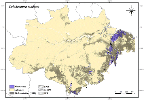
Regional threats. Rapid agricultural expansions (mainly soybean production in its western occurrence area), expansion of roads and urban areas, clearing for pasture, and fires.
Conservation status. NT (Near Threatened); it was listed in the Red List of Threatened Species of the Pará state,[Citation74] Brazil.
Gymnophthalmus Merren.[Citation121]
Gymnophthalmus leucomystax Vanzolini & Carvalho.[Citation76]
Distribution. Brazil and Guyana.
Extent of occurrence. 24,422.96 km2.
Occurrence area. In the Brazilian Amazonia Gymnophthalmus leucomystax has about 25% of its occurrence area inside protected areas, and at least 10% of its occurrence area has been degraded (Figure ).
Figure 42. Occurrence area and records of Gymnophthalmus leucomystax in the Brazilian Amazonia, showing the overlap with protected and deforested areas.

Regional threats. Rapid agricultural expansion, clearing for pasture, and fires in the Lavrado region of Roraima state.
Conservation status. LC (Least Concern); it was listed in the Brazilian Red List of Threatened Species [Citation73] as NT.
Gymnophthalmus underwoodi Grant.[Citation122]
Distribution. Brazil, French Guiana, Suriname, Guyana, Venezuela, Trinidad and Tobago, Barbados, Dominica, Guadeloupe, and Saint Vincent and Grenadines.
Extent of occurrence. 21,394.02 km2.
Occurrence area. In the Brazilian Amazonia Gymnophthalmus underwoodi has about 35% of its occurrence area inside protected areas, and at least 13% of its occurrence area has been degraded (Figure ).
Figure 43. Occurrence area and records of Gymnophtalmus underwoodi in the Brazilian Amazonia, showing the overlap with protected and deforested areas.
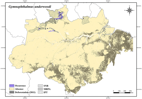
Regional threats. Rapid agricultural expansion, clearing for pasture, and fires in the Lavrado region of Roraima state.
Conservation status. LC (Least Concern); it was listed in the IUCN Red List [Citation75] as LC.
Gymnophthalmus vanzoi Carvalho.[Citation77]
Distribution. Brazil and Guyana.
Extent of occurrence. 30,236.15 km2.
Occurrence area. In the Brazilian Amazonia Gymnophthalmus vanzoi has about 35% of its occurrence area inside protected areas, and at least 5% of its occurrence area has been degraded (Figure ).
Figure 44. Occurrence area and records of Gymnophtalmus vanzoi in the Brazilian Amazonia, showing the overlap with protected and deforested areas.

Regional threats. Rapid agricultural expansion, clearing for pasture, and fires in the Lavrado region of Roraima state.
Conservation status. LC (Least Concern); it was listed in the IUCN Red List [Citation75] as DD (Data Deficient).
Gymnophthalmus sp.
Distribution. Endemic to enclaves of open vegetation along the lower Tapajós River, and in Northern Brazilian Amazonia.
Extent of occurrence. 5757.38 km2.
Occurrence area. Gymnophthalmus sp. has about 38% of its occurrence area inside protected areas, and at least 28% of its occurrence area has been degraded (Figure ).
Figure 45. Occurrence area and records of Gymnophtalmus sp., showing the overlap with protected and deforested areas.
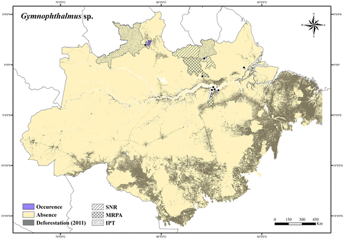
Regional threats. Rapid agricultural expansion, clearing for pasture, and fires in the Lavrado region of Roraima state; expansion of urban areas (Santarém municipality); expansion of roads and electricity transmission lines in Amapá state.
Conservation status. LC (Least Concern).
Iphisa Gray.[Citation123]
Iphisa elegans Gray.[Citation123]
Iphisa elegans elegans Gray.[Citation123]
Distribution. Brazil, French Guiana, Suriname, Guyana, Colombia, Ecuador, and Peru.
Extent of occurrence. 1,519,602.9 km2.
Occurrence area. In the Brazilian Amazonia Iphisa elegans elegans has about 50% of its occurrence area inside protected areas, and about 11% of its occurrence area has been deforested (Figure ).
Figure 46. Occurrence area and records of Iphisa elegans elegans in the Brazilian Amazonia, showing the overlap with protected and deforested areas.
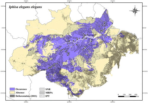
Regional threats. Deforestation (widespread species).
Conservation status. LC (Least Concern).
Iphisa elegans soinii Dixon.[Citation124]
Distribution. Brazil, Peru, and Bolivia.
Extent of occurrence. 296,833.31 km2.
Occurrence area. In the Brazilian Amazonia Iphisa elegans soinii has about 62% of its occurrence area inside protected areas, and about 2% of its occurrence area has been deforested (Figure ).
Figure 47. Occurrence area and records of Iphisa elegans soinii in the Brazilian Amazonia, showing the overlap with protected and deforested areas.
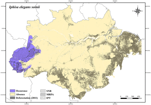
Regional threats. No current or potential threats in its occurrence area.
Conservation status. LC (Least Concern).
Leposoma Spix.[Citation125]
Leposoma ferreirai Rodrigues & Ávila-Pires.[Citation126]
Distribution. Endemic to the Anavilhanas Archipelago, in the Brazilian Amazonia.
Extent of occurrence. 469.62 km2.
Occurrence area. Leposoma ferreirai has 100% of its occurrence area inside protected areas; however about 3% of its occurrence area has been deforested (Figure ).
Figure 48. Occurrence area and records of Leposoma ferreirai, showing the overlap with protected and deforested areas.

Regional threats. Fluctuation of the Negro River level.
Conservation status. LC (Least Concern).
Leposoma guianense Ruibal.[Citation118]
Distribution. Brazil, French Guiana, Suriname, and Guyana.
Extent of occurrence. 371,930.01 km2.
Occurrence area. In the Brazilian Amazonia Leposoma guianense has about 68% of its occurrence area inside protected areas, and about 9% of its occurrence area has been deforested (Figure ).
Figure 49. Occurrence area and records of Leposoma guianense in the Brazilian Amazonia, showing the overlap with protected and deforested areas.
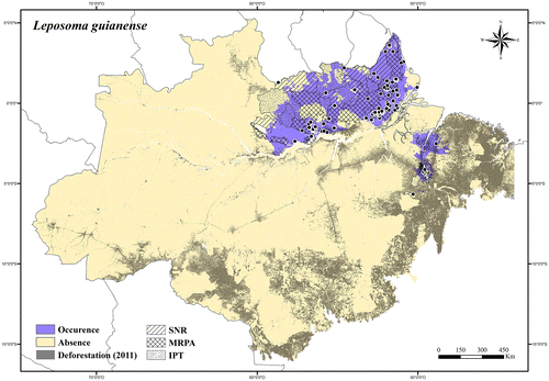
Regional threats. Expansion of roads and urban areas, clearing for pasture, fires, and mining activities in its southern occurrence area; expansion of electricity transmission lines, roads, and urban areas along the north side of the Amazon River and Atlantic coastal region.
Conservation status. LC (Least Concern).
Leposoma osvaldoi Ávila-Pires.[Citation8]
Distribution. Endemic to Southern Brazilian Amazonia.
Extent of occurrence. 661,733.57 km2.
Occurrence area. Leposoma osvaldoi has about 46% of its occurrence area inside protected areas, and about 17% of its occurrence area has been deforested (Figure ).
Figure 50. Occurrence area and records of Leposoma osvaldoi, showing the overlap with protected and deforested areas.
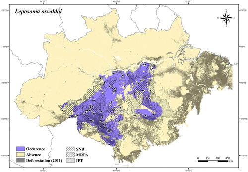
Regional threats. Rapid agricultural expansions (mainly soybean production), roads expansion, clearing for pasture, and fires in its southern occurrence area and along the Tapajós River; construction and operation of hydroelectric dams, and infrastructure associated with power stations on the Tapajós River; expansion of agricultural fields (soybean production), roads and urban areas along the Madeira River.
Conservation status. LC (Least Concern).
Leposoma percarinatum (Müller).[Citation127]
Distribution. Brazil, Suriname, Guyana, Venezuela, Peru, and Bolivia.
Extent of occurrence. 1,861,931.25 km2.
Occurrence area. In the Brazilian Amazonia Leposoma percarinatum has about 50% of its occurrence area inside protected areas, and about 11% of its occurrence area has been deforested (Figure ).
Figure 51. Occurrence area and records of Leposoma percarinatum in the Brazilian Amazonia, showing the overlap with protected and deforested areas.
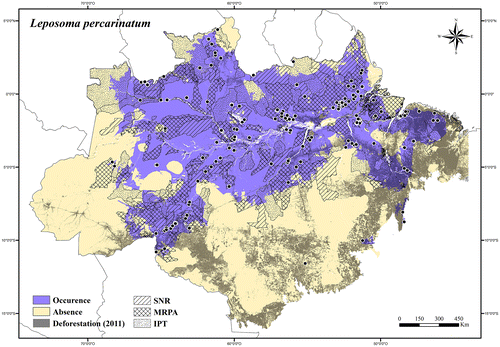
Regional threats. Deforestation (widespread species).
Conservation status. LC (Least Concern); it was listed in the IUCN Red List [Citation75] as LC.
Leposoma snethlageae Ávila-Pires.[Citation8]
Distribution. Brazil, Colombia, and Peru.
Extent of occurrence. 124,470.22 km2.
Occurrence area. In the Brazilian Amazonia Leposoma snethlageae has about 34% of its occurrence area inside protected areas, and less than 2% of its occurrence area has been deforested (Figure ).
Figure 52. Occurrence area and records of Leposoma snethlageae in the Brazilian Amazonia, showing the overlap with protected and deforested areas.
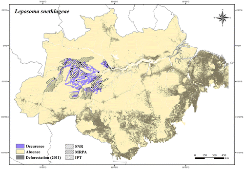
Regional threats. No current or potential threats in its occurrence area.
Conservation status. LC (Least Concern).
Leposoma sp.
Distribution. Endemic to the Negro–Paru do Oeste Interfluvium, in the Brazilian Amazonia.
Extent of occurrence. 42,180.19 km2.
Occurrence area. Leposoma sp. has about 36% of its occurrence area inside protected areas, and about 10% of its occurrence area has been deforested (Figure ).
Figure 53. Occurrence area and records of Leposoma sp., showing the overlap with protected and deforested areas.

Regional threats. Expansion of urban areas (Manaus metropolitan area); expansion of electricity transmission lines along the Amazon River; construction and operation of hydroelectric dams, and infrastructure associated with power stations on the Trombetas River.
Conservation status. LC (Least Concern).
Marinussaurus Peloso et al. [Citation128]
Marinussaurus curupira Peloso et al. [Citation128]
Distribution. Endemic to the peninsular area near the confluence of the Solimões and Negro rivers, in the Brazilian Amazonia (Appendix 1).
Extent of occurrence. 369.19 km2 (same of the area of occupancy).
Occurrence area. It is only known from two localities in Iranduba (Amazonas state), in Northern Brazilian Amazonia, amid an area originally covered by continuous forest, which at present is rather fragmented by roads and deforested parcels.
Regional threats. One of the localities where the species is known is completely deforested. The other is a forest fragment inside the new expansion region of the Manaus metropolitan area.
Conservation status. EN (Endangered) B2ab(ii,iii,iv); it was listed in the Brazilian Red List of Threatened Species [Citation73] as DD.
Micrablepharus Boettger.[Citation129]
Micrablepharus atticolus Rodrigues.[Citation130]
Distribution. Endemic to Brazil.
Extent of occurrence. 324,605.51 km2.
Occurrence area. In the Brazilian Amazonia Micrablepharus atticolus has about 23% of its occurrence area inside protected areas, and at least 41% of its occurrence area has been degraded (Figure ).
Figure 54. Occurrence area and records of Micrablepharus atticolus in the Brazilian Amazonia, showing the overlap with protected and deforested areas.
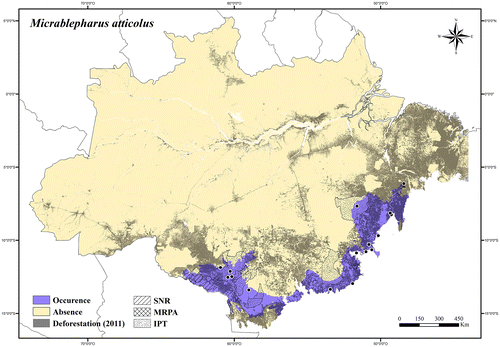
Regional threats. Rapid agricultural expansions (mainly soybean production), roads expansion, clearing for pasture, and fires.
Conservation status. NT (Near Threatened).
Micrablepharus maximiliani (Reinhardt & Lütken).[Citation120]
Distribution. Brazil, Bolivia, and Paraguay.
Extent of occurrence. 378,337.62 km2.
Occurrence area. In the Brazilian Amazonia Micrablepharus maximiliani has about 21% of its occurrence area inside protected areas, and at least 49% of its occurrence area has been degraded (Figure ).
Figure 55. Occurrence area and records of Micrablepharus maximiliani in the Brazilian Amazonia, showing the overlap with protected and deforested areas.
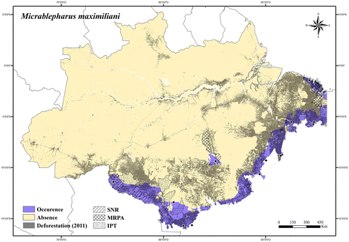
Regional threats. Rapid agricultural expansions (mainly soybean production), expansion of roads and urban areas, clearing for pasture, and fires.
Conservation status. NT (Near Threatened).
Neusticurus Duméril & Bibron.[Citation107]
Neusticurus bicarinatus (Linnaeus).[Citation100]
Distribution. Brazil, French Guiana, Suriname, Guyana, and Venezuela.
Extent of occurrence. 1,292,636.07 km2.
Occurrence area. In the Brazilian Amazonia Neusticurus bicarinatus has about 51% of its occurrence area inside protected areas, and about 20% of its occurrence area has been deforested (Figure ).
Figure 56. Occurrence area and records of Neusticurus bicarinatus in the Brazilian Amazonia, showing the overlap with protected and deforested areas.
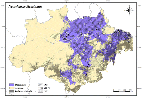
Regional threats. Expansion of roads and urban areas, clearing for pasture, and fires in its southern occurrence area; expansion of electricity transmission lines, roads, and urban areas along the north side of the Amazon River and Atlantic coastal region.
Conservation status. LC (Least Concern).
Neusticurus racenisi Roze.[Citation131]
Distribution. Brazil and Venezuela.
Extent of occurrence. 59,901.34 km2.
Occurrence area. In the Brazilian Amazonia Neusticurus racenisi has about 97% of its occurrence area inside protected areas, and less than 1% of its occurrence area has been deforested (Figure ).
Figure 57. Occurrence area and records of Neusticurus racenisi in the Brazilian Amazonia, showing the overlap with protected and deforested areas.
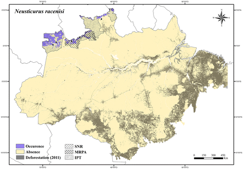
Regional threats. No current or potential threats in its occurrence area.
Conservation status. LC (Least Concern).
Neusticurus rudis Boulenger.[Citation132]
Distribution. Brazil, French Guiana, Suriname, Guyana, and Venezuela.
Extent of occurrence. 251,041.24 km2.
Occurrence area. In the Brazilian Amazonia Neusticurus rudis has about 72% of its occurrence area inside protected areas, and about 2% of its occurrence area has been deforested (Figure ).
Figure 58. Occurrence area and records of Neusticurus rudis in the Brazilian Amazonia, showing the overlap with protected and deforested areas.
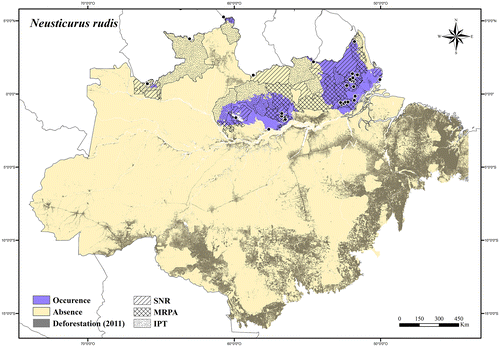
Regional threats. Expansion of roads and electricity transmission lines along the Amazon River and Atlantic coastal region; construction and operation of hydroelectric dams, and infrastructure associated with power stations on the Trombetas River.
Conservation status. LC (Least Concern).
Potamites Doan & Castoe.[Citation133]
Potamites ecpleopus (Cope).[Citation82]
Distribution. Brazil, Colombia, Ecuador, Peru, and Bolivia.
Extent of occurrence. 555,327.56 km2.
Occurrence area. In the Brazilian Amazonia Potamites ecpleopus has about 60% of its occurrence area inside protected areas, and about 15% of its occurrence area has been deforested (Figure ).
Figure 59. Occurrence area and records of Potamites ecpleopus in the Brazilian Amazonia, showing the overlap with protected and deforested areas.
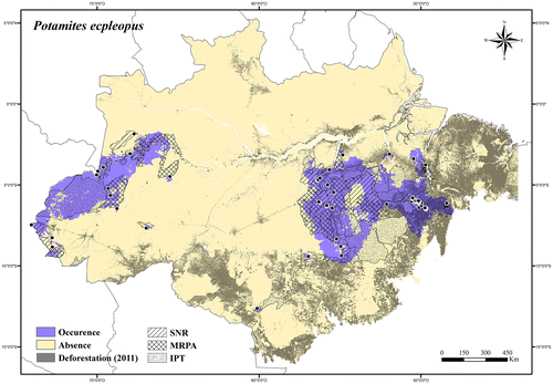
Regional threats. Rapid agricultural expansion (mainly soybean production), expansion of roads and urban areas, clearing for pasture, and fires in its eastern occurrence area; construction and operation of hydroelectric dams, and infrastructure associated with power stations on the Tapajós and Xingu rivers.
Conservation status. LC (Least Concern).
Potamites juruazensis (Ávila-Pires & Vitt).[Citation134]
Distribution. Brazil and Peru.
Extent of occurrence. 45,861.61 km2.
Occurrence area. In the Brazilian Amazonia Potamites juruazensis has about 25% of its occurrence area inside protected areas, and about 3% of its occurrence area has been deforested (Figure ).
Figure 60. Occurrence area and records of Potamites juruazensis in the Brazilian Amazonia, showing the overlap with protected and deforested areas.
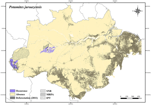
Regional threats. No current or potential threats in its occurrence area.
Conservation status. LC (Least Concern).
Ptychoglossus Boulenger.[Citation135]
Ptychoglossus brevifrontalis Boulenger.[Citation136]
Distribution. Brazil, Suriname, Venezuela, Colombia, Ecuador, Peru, and Bolivia.
Extent of occurrence. 1,645,585.44 km2.
Occurrence area. In the Brazilian Amazonia Ptychoglossus brevifrontalis has about 54% of its occurrence area inside protected areas, and about 5% of its occurrence area has been deforested (Figure ).
Figure 61. Occurrence area and records of Ptychoglossus brevifrontalis in the Brazilian Amazonia, showing the overlap with protected and deforested areas.
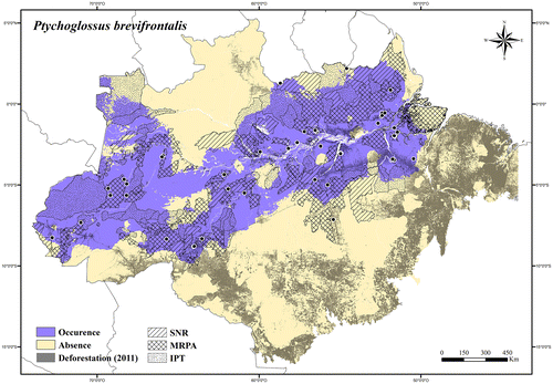
Regional threats. Deforestation (widespread species).
Conservation status. LC (Least Concern).
Rhachisaurus Pellegrino et al. [Citation137]
Rhachisaurus brachylepis (Dixon).[Citation138]
Distribution. Endemic to Brazil.
Extent of occurrence. 1885.35 km2.
Occurrence area. In the Brazilian Amazonia Rhachisaurus brachylepis has about 63% of its occurrence area inside protected areas, and about 25% of its occurrence area has been deforested (Figure ).
Figure 62. Occurrence area and record of Rhachisaurus brachylepis in the Brazilian Amazonia, showing the overlap with protected and deforested areas.

Regional threats. Mining activities, expansion of roads and urban areas, clearing for pasture, and fires.
Conservation status. LC (Least Concern); it was listed in the Brazilian Red List of Threatened Species [Citation73] as DD.
Rondonops Colli et al. [Citation139]
Rondonops biscutatus Colli et al. [Citation139]
Distribution. Endemic to Southern Brazilian Amazonia.
Extent of occurrence. 90,674.1 km2.
Occurrence area. In the Brazilian Amazonia Rondonops biscutatus has about 55% of its occurrence area inside protected areas, and about 22% of its occurrence area has been deforested (Figure ).
Figure 63. Occurrence area and records of Rondonops biscutatus in the Brazilian Amazonia, showing the overlap with protected and deforested areas.
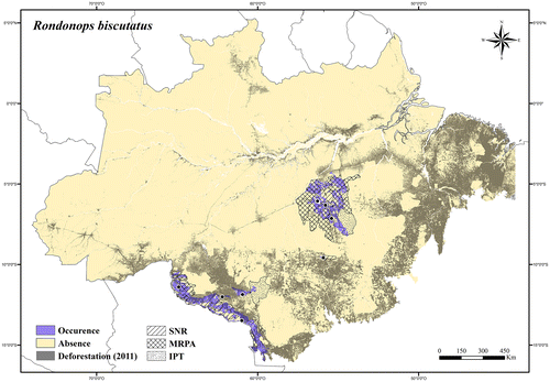
Regional threats. Rapid agricultural expansions (mainly soybean production), expansion of roads and urban areas, clearing for pasture, and fires; construction and operation of hydroelectric dams, and infrastructure associated with power stations on the Tapajós River.
Conservation status. LC (Least Concern).
Rondonops xanthomystax Colli et al. [Citation139]
Distribution. Endemic to Southern Brazilian Amazonia.
Extent of occurrence. 56,710.16 km2.
Occurrence area. In the Brazilian Amazonia Rondonops xanthomystax has about 36% of its occurrence area inside protected areas, and about 5% of its occurrence area has been deforested (Figure ).
Figure 64. Occurrence area and records of Rondonops xanthomystax in the Brazilian Amazonia, showing the overlap with protected and deforested areas.
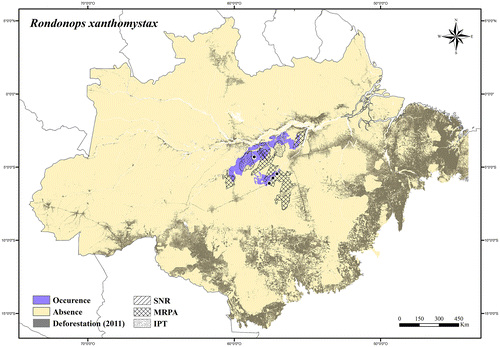
Regional threats. Expansion of roads and urban areas, clearing for pasture, and fires in its southern occurrence area; construction and operation of hydroelectric dams, and infrastructure associated with power stations on the Tapajós River.
Conservation status. LC (Least Concern).
Tretioscincus Cope.[Citation140]
Tretioscincus agilis (Ruthven).[Citation141]
Distribution. Brazil, French Guiana, and Suriname.
Extent of occurrence. 404,319.4 km2.
Occurrence area. In the Brazilian Amazonia Tretioscincus agilis has about 59% of its occurrence area inside protected areas, and about 11% of its occurrence area has been deforested (Figure ).
Figure 65. Occurrence area and records of Tretioscincus agilis in the Brazilian Amazonia, showing the overlap with protected and deforested areas.
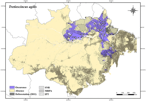
Regional threats. Expansion of roads and urban areas, clearing for pasture, fires, and mining activities in its southern occurrence area; construction and operation of hydroelectric dams, and infrastructure associated with power stations on the Xingu River; expansion of electricity transmission lines, roads, and urban areas along the north side of the Amazon River and Atlantic coastal region.
Conservation status. LC (Least Concern).
Tretioscincus oriximinensis Ávila-Pires.[Citation8]
Distribution. Brazil, Venezuela, and Colombia.
Extent of occurrence. 115,777.88 km2.
Occurrence area. In the Brazilian Amazonia Tretioscincus oriximinensis has about 48% of its occurrence area inside protected areas, and about 10% of its occurrence area has been deforested (Figure ).
Figure 66. Occurrence area and records of Tretioscincus oriximinensis in the Brazilian Amazonia, showing the overlap with protected and deforested areas.
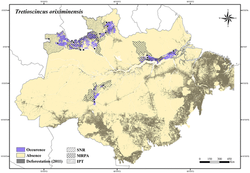
Regional threats. Construction and operation of hydroelectric dams, and infrastructure associated with power stations on the Trombetas River; expansion of electricity transmission lines, roads, and urban areas along the north side of the Amazon River; rapid agricultural expansion, clearing for pasture, and fires in the Lavrado region of Roraima state.; expansion of agricultural fields (soybean production) and roads along the Madeira River.
Conservation status. LC (Least Concern).
Hoplocercidae
Enyalioides Boulenger.[Citation99]
Enyalioides laticeps (Guichenot).[Citation142]
Distribution. Brazil, Colombia, Ecuador, and Peru.
Extent of occurrence. 741,558.28 km2.
Occurrence area. In the Brazilian Amazonia Enyalioides laticeps has about 52% of its occurrence area inside protected areas, and about 11% of its occurrence area has been deforested (Figure ).
Figure 67. Occurrence area and records of Enyalioides laticeps in the Brazilian Amazonia, showing the overlap with protected and deforested areas.
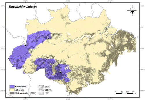
Regional threats. Rapid agricultural expansions (mainly soybean production), expansion of roads and urban areas, clearing for pasture, and fires in its southern occurrence area.
Conservation status. LC (Least Concern).
Enyalioides palpebralis (Boulenger).[Citation143]
Distribution. Brazil, Peru, and Bolivia.
Extent of occurrence. 286,672.46 km2.
Occurrence area. In the Brazilian Amazonia Enyalioides palpebralis has about 62% of its occurrence area inside protected areas, and less than 3% of its occurrence area has been deforested (Figure ).
Figure 68. Occurrence area and records of Enyalioides palpebralis in the Brazilian Amazonia, showing the overlap with protected and deforested areas.
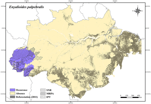
Regional threats. Expansion of roads and urban areas in its southern occurrence area.
Conservation status. LC (Least Concern).
Hoplocercus Fitzinger.[Citation144]
Hoplocercus spinosus Fitzinger.[Citation144]
Distribution. Brazil and Bolivia.
Extent of occurrence. 138,800.55 km2.
Occurrence area. In the Brazilian Amazonia Hoplocercus spinosus has about 34% of its occurrence area inside protected areas, and at least 31% of its occurrence area has been deforested (Figure ).
Figure 69. Occurrence area and records of Hoplocercus spinosus in the Brazilian Amazonia, showing the overlap with protected and deforested areas.
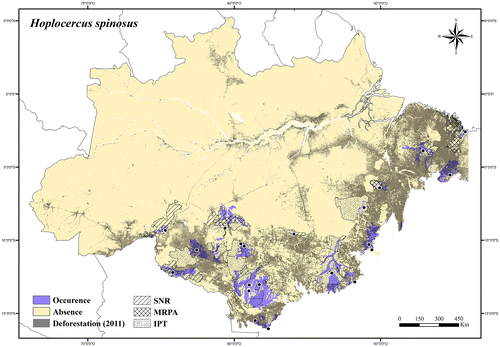
Regional threats. Rapid agricultural expansions (mainly soybean production), expansion of roads and urban areas, clearing for pasture, and fires.
Conservation status. LC (Least Concern).
Iguanidae
Iguana Laurenti.[Citation145]
Iguana iguana (Linnaeus).[Citation100]
Distribution. Mexico, Belize, Guatemala, El Salvador, Honduras, Nicaragua, Costa Rica, Panama, British Virgin Islands, United States Virgin Islands, Netherlands Antilles, Montserrat, Guadaloupe, Aruba, Saint Lucia, Saint Vincent and Grenadines, Grenada, Brazil, French Guiana, Suriname, Guyana, Venezuela, Trinidad and Tobago, Colombia, Ecuador, Peru, Bolivia, and Paraguay.
Extent of occurrence. 3,919,068.44 km2.
Occurrence area. In the Brazilian Amazonia Iguana iguana has about 47% of its occurrence area inside protected areas, and at least 18% of its occurrence area has been deforested (Figure ).
Figure 70. Occurrence area and records of Iguana iguana in the Brazilian Amazonia, showing the overlap with protected and deforested areas.
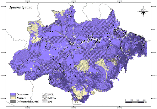
Regional threats. Deforestation (widespread species); commercial use of the animal (or parts of it) in traditional medicines, skin trade, and for food.
Conservation status. LC (Least Concern); it is listed in Appendix II [Citation146] of CITES.
Leiosauridae
Enyalius Wagler.[Citation115]
Enyalius leechii (Boulenger).[Citation99]
Distribution. Endemic to Southern Brazilian Amazonia.
Extent of occurrence. 317,308.71 km2.
Occurrence area. Enyalius leechii has about 41% of its occurrence area inside protected areas, and about 28% of its occurrence area has been deforested (Figure ).
Figure 71. Occurrence area and records of Enyalius leechii, showing the overlap with protected and deforested areas.
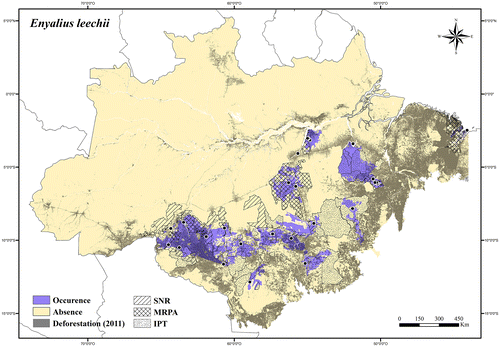
Regional threats. Rapid agricultural expansions (mainly soybean production), expansion of roads and urban areas, clearing for pasture, fires, and mining activities; construction and operation of hydroelectric dams, and infrastructure associated with power stations on the Madeira, Tapajós, and Xingu rivers.
Conservation status. LC (Least Concern).
Mabuyidae
Copeoglossum Tschudi.[Citation147]
Copeoglossum nigropunctatum (Spix).[Citation125]
Distribution. Brazil, French Guiana, Suriname, Guyana, Colombia, Ecuador, Peru, and Bolivia.
Extent of occurrence. 3,975,062.58 km2.
Occurrence area. In the Brazilian Amazonia Copeoglossum nigropunctatum has about 47% of its occurrence area inside protected areas, and about 17% of its occurrence area has been deforested (Figure ).
Figure 72. Occurrence area and records of Copeoglossum nigropunctatum in the Brazilian Amazonia, showing the overlap with protected and deforested areas.
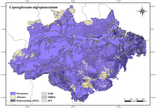
Regional threats. Deforestation (widespread species).
Conservation status. LC (Least Concern).
Exila Hedges & Conn.[Citation148]
Exila nigropalmata (Andersson).[Citation149]
Distribution. Brazil, Peru, and Bolivia.
Extent of occurrence. 53,215.04 km2.
Occurrence area. In the Brazilian Amazonia Exila nigropalmata has about 74% of its occurrence area inside protected areas, and about 1% of its occurrence area has been deforested (Figure ).
Figure 73. Occurrence area and records of Exila nigropalmata in the Brazilian Amazonia, showing the overlap with protected and deforested areas.
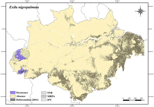
Regional threats. Expansion of roads and urban areas in its southern occurrence area.
Conservation status. LC (Least Concern).
Manciola Hedges & Conn.[Citation148]
Manciola guaporicola (Dunn).[Citation150]
Distribution. Brazil and Bolivia.
Extent of occurrence. 276,715.95 km2.
Occurrence area. In the Brazilian Amazonia Manciola guaporicola has about 24% of its occurrence area inside protected areas, and about 36% of its occurrence area has been deforested (Figure ).
Figure 74. Occurrence area and records of Manciola guaporicola in the Brazilian Amazonia, showing the overlap with protected and deforested areas.
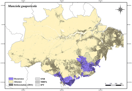
Regional threats. Rapid agricultural expansions (mainly soybean production), expansion of roads, clearing for pasture, and fires.
Conservation status. NT (Near Threatened).
Notomabuya Hedges & Conn.[Citation148]
Notomabuya frenata (Cope).[Citation140]
Distribution. Brazil, Argentina, Paraguay, and Bolivia.
Extent of occurrence. 292,243.57 km2.
Occurrence area. In the Brazilian Amazonia Notomabyua frenata has about 18% of its occurrence area inside protected areas, and about 52% of its occurrence area has been deforested (Figure ).
Figure 75. Occurrence area and records of Notomabuya frenata in the Brazilian Amazonia, showing the overlap with protected and deforested areas.
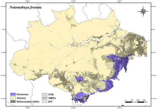
Regional threats. Rapid agricultural expansions (mainly soybean production), expansion of roads, clearing for pasture, fires, and mining activities.
Conservation status. NT (Near Threatened).
Panopa Hedges & Conn.[Citation148]
Panopa carvalhoi (Rebouças-Spieker & Vanzolini).[Citation151]
Distribution. Brazil and Venezuela.
Extent of occurrence. 88,565.52 km2.
Occurrence area. In the Brazilian Amazonia Panopa carvalhoi has about 59% of its occurrence area inside protected areas, and about 6% of its occurrence area has been deforested (Figure ).
Figure 76. Occurrence area and records of Panopa carvalhoi in the Brazilian Amazonia, showing the overlap with protected and deforested areas.
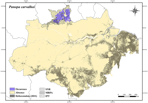
Regional threats. Rapid agricultural expansion, clearing for pasture, and fires in the Lavrado region of Roraima state.
Conservation status. LC (Least Concern); it was listed in the IUCN Red List [Citation75] as LC.
Varzea Hedges & Conn.[Citation148]
Varzea altamazonica (Miralles) et al. [Citation152]
Distribution. Brazil, Colombia, Ecuador, Peru, and Bolivia.
Extent of occurrence. 566,140.06 km2.
Occurrence area. In the Brazilian Amazonia Varzea altamazonica has about 56% of its occurrence area inside protected areas, and at least 3% of its occurrence area has been deforested (Figure ).
Figure 77. Occurrence area and records of Varzea altamazonica in the Brazilian Amazonia, showing the overlap with protected and deforested areas.
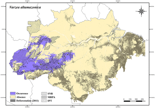
Regional threats. Impacts associated with the degradation of varzea forests (logging and palm extraction) and with savanna enclaves (agricultural conversion); construction and operation of hydroelectric dams, and infrastructure associated with power stations on the Madeira River.
Conservation status. LC (Least Concern).
Varzea bistriata (Spix).[Citation125]
Distribution. Brazil, French Guiana, Colombia, Peru, and Bolivia.
Extent of occurrence. 892,652.32 km2.
Occurrence area. In the Brazilian Amazonia Varzea bistriata has about 44% of its occurrence area inside protected areas, and at least 11% of its occurrence area has been deforested (Figure ).
Figure 78. Occurrence area and records of Varzea bistriata in the Brazilian Amazonia, showing the overlap with protected and deforested areas.
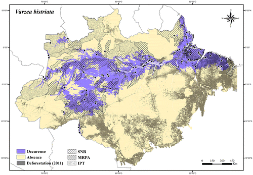
Regional threats. Impacts associated with the degradation of varzea forest (logging and palm extraction) and with savanna enclaves (agricultural conversion); construction and operation of hydroelectric dams, and infrastructure associated with power stations on the Xingu, Trombetas and Madeira rivers; expansion of roads and urban areas along the north side of the Amazon River and in its eastern occurrence area.
Conservation status. LC (Least Concern); it was listed in the IUCN Red List [Citation75] as LC.
Phyllodactylidae
Gymnodactylus Spix.[Citation125]
Gymnodactylus amarali Barbour.[Citation153]
Distribution. Endemic to Brazil.
Extent of occurrence. 48,619.25 km2.
Occurrence area. In the Brazilian Amazonia Gymnodactylus amarali has about 5% of its occurrence area inside protected areas, and at least 70% of its occurrence area has been degraded (Figure ).
Figure 79. Occurrence area and records of Gymnodactylus amarali in the Brazilian Amazonia, showing the overlap with protected and deforested areas.
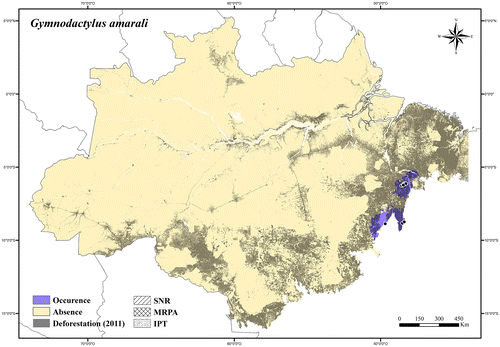
Regional threats. Mining activities, expansion of roads and urban areas, clearing for pasture, and fires.
Conservation status. VU A2c (Vulnerable).
Phyllopezus Peters.[Citation154]
Phyllopezus pollicaris (Spix).[Citation125]
Distribution. Brazil, Bolívia, Argentina, and Paraguay.
Extent of occurrence. 34,271.29 km2.
Occurrence area. In the Brazilian Amazonia Phyllopezus pollicaris has about 14% of its occurrence area inside protected areas, and at least 69% of its occurrence area has been degraded (Figure ).
Figure 80. Occurrence area and records of Phyllopezus pollicaris in the Brazilian Amazonia, showing the overlap with protected and deforested areas.

Regional threats. Mining activities, expansion of roads and urban areas, clearing for pasture, and fires.
Conservation status. VU A2c (Vulnerable).
Thecadactylus Oken.[Citation96]
Thecadactylus rapicauda (Houttuyn).[Citation155]
Distribution. Mexico, Belize, Guatemala, Honduras, Nicaragua, Costa Rica, Panama, Cuba, British Virgin Islands, United States Virgin Islands, Netherlands Antilles, Saint Barthelemy, Antigua and Barbuda, Montserrat, Guadaloupe, Dominica, Martinique, Saint Lucia, Saint Vincent and Grenadines, Grenada, Curacao, Trinidad and Tobago, Brazil, French Guiana, Suriname, Guyana, Venezuela, and Colombia.
Extent of occurrence. 1,448,022.79 km2.
Occurrence area. In the Brazilian Amazonia Thecadactylus rapicauda has about 51% of its occurrence area inside protected areas, and about 18% of its occurrence area has been deforested (Figure ).
Figure 81. Occurrence area and records of Thecadactylus rapicauda in the Brazilian Amazonia, showing the overlap with protected and deforested areas.
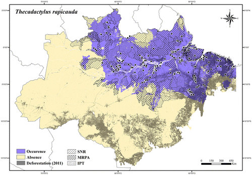
Regional threats. Rapid agricultural expansions (mainly soybean production), expansion of roads and urban areas, clearing for pasture, and fires in its southern occurrence area; expansion of electricity transmission lines, roads, and urban areas along the north side of the Amazon River and Atlantic coastal region; rapid agricultural expansions, clearing for pasture, and fires in the Lavrado region of Roraima state.
Conservation status. LC (Least Concern).
Thecadactylus solimoensis Bergamnn & Russell.[Citation156]
Distribution. Brazil, Colombia, Ecuador, Peru and Bolivia.
Extent of occurrence. 649,936.36 km2.
Occurrence area. In the Brazilian Amazonia Thecadactylus solimoensis has about 51% of its occurrence area inside protected areas, and about 12% of its occurrence area has been deforested (Figure ).
Figure 82. Occurrence area and records of Thecadactylus solimoensis in the Brazilian Amazonia, showing the overlap with protected and deforested areas.
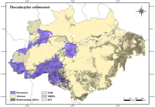
Regional threats. Expansion of agricultural fields (soybean production), roads, and urban areas in its southern occurrence area and along the Madeira River.
Conservation status. LC (Least Concern).
Polychrotidae
Polychrus Cuvier.[Citation157]
Polychrus acutirostris Spix.[Citation125]
Distribution. Brazil, Bolivia, Paraguay, and Argentina.
Extent of occurrence. 261,020.08 km2.
Occurrence area. In the Brazilian Amazonia Polychrus acutirostris has about 30% of its occurrence area inside protected areas, and at least 37% of its occurrence area has been deforested (Figure ).
Figure 83. Occurrence area and records of Polychrus acutirostris in the Brazilian Amazonia, showing the overlap with protected and deforested areas.
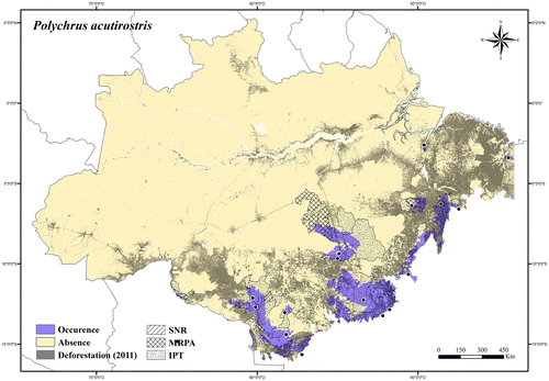
Regional threats. Rapid agricultural expansions (mainly soybean production), expansion of roads and urban areas, clearing for pasture, and fires.
Conservation status. NT (Near Threatened).
Polychrus liogaster Boulenger.[Citation158]
Distribution. Brazil, Ecuador, Peru, and Bolivia.
Extent of occurrence. 208,758.02 km2.
Occurrence area. In the Brazilian Amazonia Polychrus liogaster has about 45% of its occurrence area inside protected areas, and about 27% of its occurrence area has been deforested (Figure ).
Figure 84. Occurrence area and records of Polychrus liogaster in the Brazilian Amazonia, showing the overlap with protected and deforested areas.
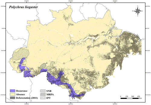
Regional threats. Expansion of roads and urban areas in its western occurrence area; rapid agricultural expansions (mainly soybean production), clearing for pasture, and fires in its eastern occurrence area.
Conservation status. LC (Least Concern).
Polychrus marmoratus (Linnaeus).[Citation100]
Distribution. Panama, Trinidad and Tobago, Brazil, French Guiana, Suriname, Guyana, Venezuela, Colombia, Ecuador, Peru, and Bolivia.
Extent of occurrence. 2,372,873.04 km2.
Occurrence area. In the Brazilian Amazonia Polychrus marmoratus has about 49% of its occurrence area inside protected areas, and about 16% of its occurrence area has been deforested (Figure ).
Figure 85. Occurrence area and records of Polychrus marmoratus in the Brazilian Amazonia, showing the overlap with protected and deforested areas.
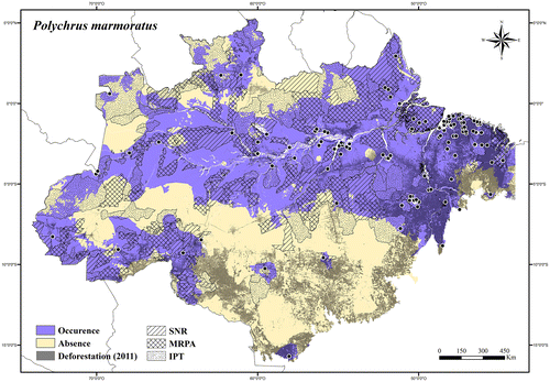
Regional threats. Deforestation (widespread species).
Conservation status. LC (Least Concern).
Sphaerodactylidae
Chatogekko Gamble et al. [Citation159]
Chatogekko amazonicus (Andersson).[Citation149]
Distribution. Brazil, French Guiana, Suriname, Guyana, Venezuela, and Bolivia.
Extent of occurrence. 2,703,765.57 km2.
Occurrence area. In the Brazilian Amazonia Chatogekko amazonicus has about 51% of its occurrence area inside protected areas, and about 15% of its occurrence area has been deforested (Figure ).
Figure 86. Occurrence area and records of Chatogekko amazonicus in the Brazilian Amazonia, showing the overlap with protected and deforested areas.
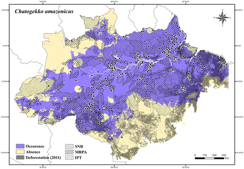
Regional threats. Deforestation (widespread species).
Conservation status. LC (Least Concern).
Coleodactylus Parker.[Citation160]
Coleodactylus meridionalis (Boulenger).[Citation161]
Distribution. Endemic to Brazil.
Extent of occurrence. 6451.94 km2.
Occurrence area. In the Brazilian Amazonia Coleodactylus meridionalis has about 17% of its occurrence area inside protected areas, and about 67% of its occurrence area has been deforested (Figure ).
Figure 87. Occurrence area and record of Coleodactylus meridionalis in the Brazilian Amazonia, showing the overlap with protected and deforested areas.
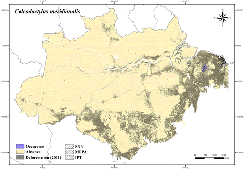
Regional threats. Mining activities, expansion of roads and urban areas, clearing for pasture, and fires.
Conservation status. VU A2c (Vulnerable).
Coleodactylus septentrionalis Vanzolini.[Citation162]
Distribution. Brazil, Guyana, and Venezuela.
Extent of occurrence. 32,276.04 km2.
Occurrence area. In the Brazilian Amazonia Coleodactylus septentrionalis has about 25% of its occurrence area inside protected areas, and at least 15% of its occurrence area has been deforested (Figure ).
Figure 88. Occurrence area and records of Coleodactylus septentrionalis in the Brazilian Amazonia, showing the overlap with protected and deforested areas.
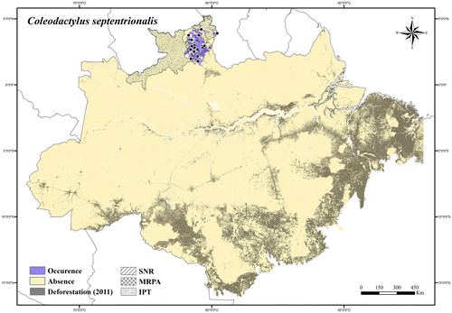
Regional threats. Rapid agricultural expansion, clearing for pasture, and fires in the Lavrado region of Roraima state.
Conservation status. LC (Least Concern); it was listed in the IUCN Red List [Citation75] as LC.
Gonatodes Fitzinger.[Citation144]
Gonatodes annularis Boulenger.[Citation163]
Distribution. Brazil, French Guiana, Suriname, Guyana, and Venezuela.
Extent of occurrence. 145,808.84 km2.
Occurrence area. In the Brazilian Amazonia Gonatodes annularis has about 73% of its occurrence area inside protected areas, and about 2% of its occurrence area has been deforested (Figure ).
Figure 89. Occurrence area and records of Gonatodes annularis in the Brazilian Amazonia, showing the overlap with protected and deforested areas.
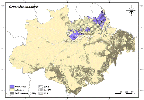
Regional threats. Expansion of electricity transmission lines, roads, and urban areas along the Amazon River and Atlantic coastal region.
Conservation status. LC (Least Concern).
Gonatodes eladioi Nascimento et al. [Citation164]
Distribution. Endemic to Southern Brazilian Amazonia.
Extent of occurrence. 47,666.27 km2.
Occurrence area. Gonatodes eladioi has about 54% of its occurrence area inside protected areas, and about 36% of its occurrence area has been deforested (Figure ).
Figure 90. Occurrence area and records of Gonatodes eladioi, showing the overlap with protected and deforested areas.
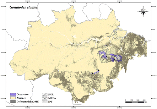
Regional threats. Mining activities, expansion of roads and urban areas, clearing for pasture, and fires.
Conservation status. NT (Near Threatened).
Gonatodes hasemani Griffin.[Citation165]
Distribution. Brazil, Peru, and Bolivia.
Extent of occurrence. 1,432,302.03 km2.
Occurrence area. In the Brazilian Amazonia Gonatodes hasemani has about 46% of its occurrence area inside protected areas, and about 13% of its occurrence area has been deforested (Figure ).
Figure 91. Occurrence area and records of Gonatodes hasemani in the Brazilian Amazonia, showing the overlap with protected and deforested areas.
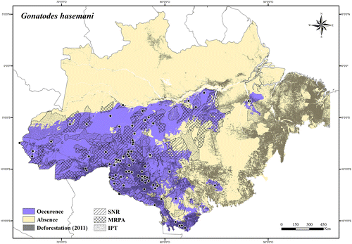
Regional threats. Rapid agricultural expansions (mainly soybean production), expansion of roads and urban areas, clearing for pasture, and fires in its southern occurrence area and along the Tapajós River; construction and operation of hydroelectric dams, and infrastructure associated with power stations on the Tapajós and Xingu rivers; expansion of agricultural fields (soybean production), roads, and urban areas along the Madeira River.
Conservation status. LC (Least Concern); it was listed in the IUCN Red List [Citation75] as LC.
Gonatodes humeralis (Guichenot).[Citation142]
Distribution. Trinidad and Tobago, Brazil, French Guiana, Suriname, Guyana, Venezuela, Colombia, Ecuador, Peru, and Bolivia.
Extent of occurrence. 3,688,274.21 km2.
Occurrence area. In the Brazilian Amazonia Gonatodes humeralis has about 51% of its occurrence area inside protected areas, and about 15% of its occurrence area has been deforested (Figure ).
Figure 92. Occurrence area and records of Gonatodes humeralis in the Brazilian Amazonia, showing the overlap with protected and deforested areas.
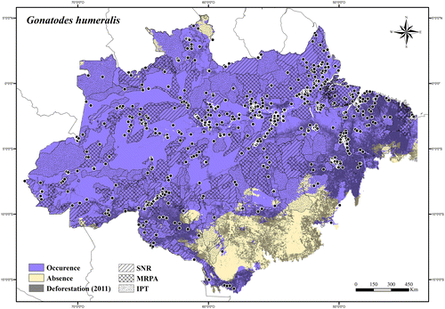
Regional threats. Deforestation (widespread species).
Conservation status. LC (Least Concern).
Gonatodes nascimentoi Sturaro & Ávila-Pires.[Citation166]
Distribution. Endemic to Eastern Brazilian Amazonia.
Extent of occurrence. 109,505.38 km2.
Occurrence area. Gonatodes nascimentoi has about 69% of its occurrence area inside protected areas, and about 11% of its occurrence area has been deforested (Figure ).
Figure 93. Occurrence area and records of Gonatodes nascimentoi, showing the overlap with protected and deforested areas.
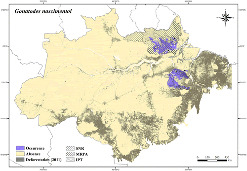
Regional threats. Construction and operation of hydroelectric dams, and infrastructure associated with power stations on the Jari and Xingu rivers; expansion of electricity transmission lines and roads in its northern occurrence area; clearing for pasture, fires, and expansion of roads and urban areas in its southern occurrence area.
Conservation status. LC (Least Concern).
Gonatodes tapajonicus Rodrigues.[Citation167]
Distribution. Endemic to the Jamanxin and Tapajós river systems, in the Brazilian Amazonia.
Extent of occurrence. 1716.21 km2.
Occurrence area. Gonatodes tapajonicus has about 56% of its occurrence area inside protected areas, and about 11% of its occurrence area has been deforested (Figure ).
Figure 94. Occurrence area and records of Gonatodes tapajonicus, showing the overlap with protected and deforested areas.
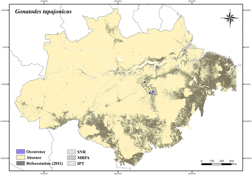
Regional threats. Construction and operation of hydroelectric dams, and infrastructure associated with power stations on the Tapajós and Jamanxin rivers; expansion of roads, degradation of Euterpe oleracea forests, and fluctuation of the Tapajós and Jamanxin rivers level.
Conservation status. EN (Endangered) B1ab(iii); it was listed in the Brazilian Red List of Threatened Species [Citation73] as EN B1ab(iii).
Lepidoblepharis Peracca.[Citation168]
Lepidoblepharis heyerorum Vanzolini.[Citation169]
Distribution. Brazil, French Guiana, and Peru.
Extent of occurrence. 1,254,321.88 km2.
Occurrence area. In the Brazilian Amazonia Lepidoblepharis heyerorum has about 45% of its occurrence area inside protected areas, and about 11% of its occurrence area has been deforested (Figure ).
Figure 95. Occurrence area and records of Lepidoblepharis heyerorum in the Brazilian Amazonia, showing the overlap with protected and deforested areas.
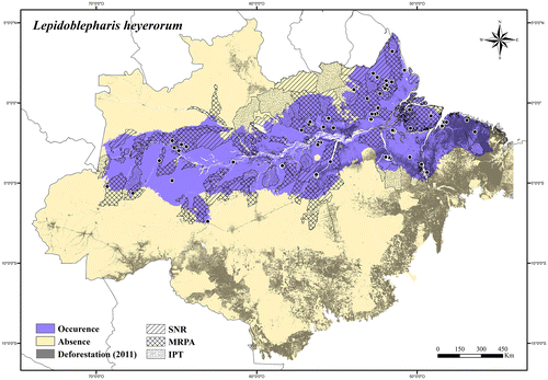
Regional threats. Deforestation (widespread species).
Conservation status. LC (Least Concern).
Lepidoblepharis hoogmoedi Ávila-Pires.[Citation8]
Distribution. Brazil and Peru.
Extent of occurrence. 97,348.41 km2.
Occurrence area. In the Brazilian Amazonia Lepidoblepharis hoogmoedi has about 64% of its occurrence area inside protected areas, and less than 1% of its occurrence area has been deforested (Figure ).
Figure 96. Occurrence area and records of Lepidoblepharis hoogmoedi in the Brazilian Amazonia, showing the overlap with protected and deforested areas.
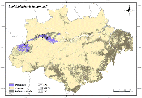
Regional threats. No current or potential threats in its occurrence area.
Conservation status. LC (Least Concern).
Pseudogonatodes Ruthven.[Citation170]
Pseudogonatodes gasconi Ávila-Pires & Hoogmoed.[Citation171]
Distribution. Endemic to the Juruá river system, in the Brazilian Amazonia (Appendix 1).
Extent of occurrence. Not analyzed.
Occurrence area. It is only known from the type-locality, Poromgaba, state of Acre, in Southern Brazilian Amazonia (see [Citation171]).
Regional threats. No current or potential threats in type-locality.
Conservation status. DD (Data Deficient).
Pseudogonatodes guianensis Parker.[Citation172]
Distribution. Brazil, French Guiana, Suriname, Guyana, Venezuela, Colombia, Ecuador, and Peru.
Extent of occurrence. 777,776.78 km2.
Occurrence area. In the Brazilian Amazonia Pseudogonatodes guianensis has about 61% of its occurrence area inside protected areas, and about 5% of its occurrence area has been deforested (Figure ).
Figure 97. Occurrence area of Pseudogonatodes guianensis in the Brazilian Amazonia, showing the overlap with protected and deforested areas.
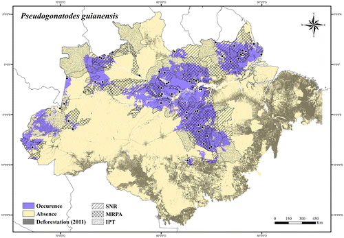
Regional threats. Deforestation (widespread species).
Conservation status. LC (Least Concern).
Teiidae
Ameiva Meyer.[Citation173]
Ameiva ameiva (Linnaeus).[Citation100]
Distribution. Widespread in South America (except Uruguay and Chile).
Extent of occurrence. 4,263,809.28 km2.
Occurrence area. In the Brazilian Amazonia Ameiva ameiva has about 48% of its occurrence area inside protected areas, and at least 17% of its occurrence area has been deforested (Figure ).
Figure 98. Occurrence area and records of Ameiva ameiva in the Brazilian Amazonia, showing the overlap with protected and deforested areas.
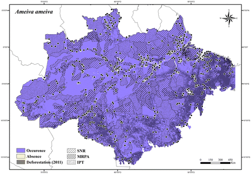
Regional threats. Deforestation (widespread species).
Conservation status. LC (Least Concern).
Ameiva parecis (Colli) et al. [Citation174]
Distribution. Endemic to enclaves of open vegetation in Southern Brazilian Amazonia.
Extent of occurrence. 29,609.41 km2.
Occurrence area. Ameiva parecis has about 42% of its occurrence area inside protected areas, and at least 11% of its occurrence area has been deforested (Figure ).
Figure 99. Occurrence area and records of Ameiva parecis in the Brazilian Amazonia, showing the overlap with protected and deforested areas.
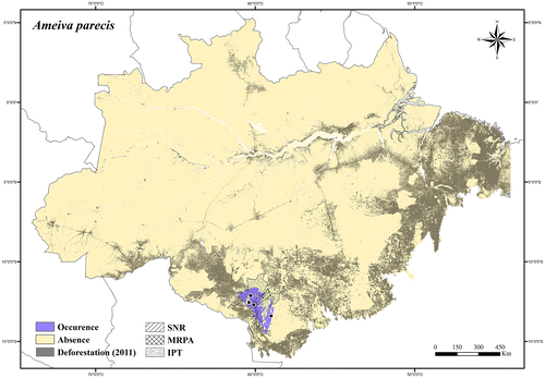
Regional threats. Rapid agricultural expansions (mainly soybean production), expansion of roads and urban areas, clearings for pasture, and fires.
Conservation status. NT (Near Threatened); it was listed in the Brazilian Red List of Threatened Species [Citation73] as EN B1ab(iii).
Cnemidophorus Wagler.[Citation115]
Cnemidophorus cryptus Cole & Dessauer.[Citation175]
Distribution. Brazil, Suriname, and Venezuela
Extent of occurrence. 119,655.92 km2.
Occurrence area. In the Brazilian Amazonia Cnemidophorus cryptus has about 20% of its occurrence area inside protected areas, and at least 38% of its occurrence area has been degraded (Figure ).
Figure 100. Occurrence area and records of Cnemidophorus cryptus in the Brazilian Amazonia, showing the overlap with protected and deforested areas.
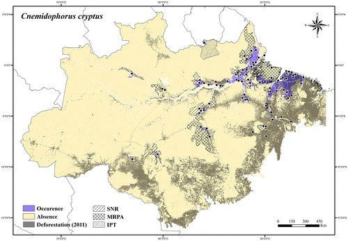
Regional threats. Expansion of electricity transmission lines, roads, and urban areas along the Amazon River and Atlantic coastal region; expansion of roads and urban areas in its southern occurrence area.
Conservation status. LC (Least Concern).
Cnemidophorus lemniscatus (Linnaeus).[Citation100]
Distribution. Guatemala, Honduras, Nicaragua, Costa Rica, Panama, Trinidad and Tobago, Colombia, Venezuela, Guyana, Suriname, French Guiana, and Brazil.
Extent of occurrence. 61,314.53 km2.
Occurrence area. In Brazilian Amazonia Cnemidophorus lemniscatus has about 41% of its occurrence area inside protected areas, and at least 14% of its occurrence area has been degraded (Figure ).
Figure 101. Occurrence area and records of Cnemidophorus lemniscatus in the Brazilian Amazonia, showing the overlap with protected and deforested areas.
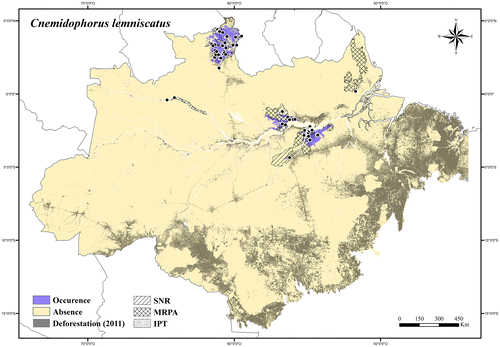
Regional threats. Expansion of electricity transmission lines and roads along the north side of the Amazon River; construction and operation of hydroelectric dams, and infrastructure associated with power stations on the Trombetas River; expansion of roads and urban areas in its southern occurrence area; rapid agricultural expansion, clearing for pasture, and fires in the Lavrado region of Roraima state.
Conservation status. LC (Least Concern).
Cnemidophorus sp. 1
Distribution. Brazil and Colombia.
Extent of occurrence. 51,687.69 km2.
Occurrence area. In the Brazilian Amazonia Cnemidophorus sp. 1 has about 45% of its occurrence area inside protected areas, and at least 10% of its occurrence area has been degraded (Figure ).
Figure 102. Occurrence area and records of Cnemidophorus sp. 1 in the Brazilian Amazonia, showing the overlap with protected and deforested areas.
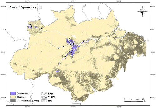
Regional threats. Rapid agricultural expansions (mainly soybean production), expansion of roads and urban areas in its southern occurrence area; expansion of roads along the Madeira River; expansion of roads and urban areas along the Amazon rivers.
Conservation status. LC (Least Concern).
Cnemidophorus sp. 2
Distribution. Endemic to the Trombetas river system, in the Brazilian Amazonia (Appendix 1).
Extent of occurrence. Not analyzed.
Occurrence area. It is only known from two localities, both in the same enclave of open vegetation near the Sapucuá Lake in Oriximina, Pará state, in Northern Brazilian Amazonia.
Regional threats. Expansion of electricity transmission lines and roads along the north side of the Amazon River. The open vegetation enclave where the specimens were found is crossed by the Oriximiná–Cariri Transmission Line.
Conservation status. DD (Data Deficient).
Cnemidophorus sp. 3
Distribution. Endemic to the Negro river system, in the Brazilian Amazonia (Appendix 1).
Extent of occurrence. Not analyzed.
Occurrence area. It is known from three localities of open vegetation in São Gabriel da Cachoeira, Amazonas state, in Northern Brazilian Amazonia.
Regional threats. No current or potential threats in its occurrence area.
Conservation status. LC (Least Concern).
Crocodilurus Spix.[Citation125]
Crocodilurus amazonicus Spix.[Citation125]
Distribution. Brazil, French Guiana, Venezuela, Colombia, and Peru.
Extent of occurrence. 1,033,775.23 km2.
Occurrence area. In the Brazilian Amazonia Crocodilurus amazonicus has about 42% of its occurrence area inside protected areas, and about 6% of its occurrence area has been deforested (Figure ).
Figure 103. Occurrence area and records of Crocodilurus amazonicus in the Brazilian Amazonia, showing the overlap with protected and deforested areas.
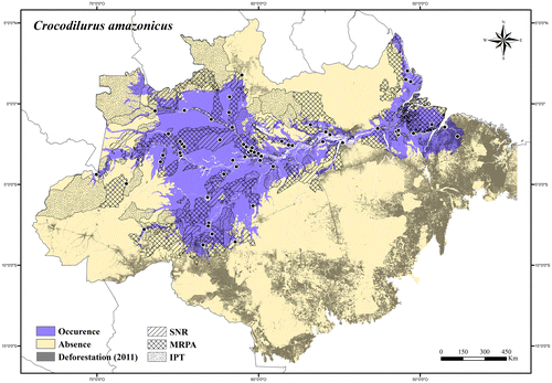
Regional threats. Deforestation of riparian forests and pollution of rivers (widespread species, but usually found on the margins of rivers, streams, and lakes); commercial use of the animal (or parts of it) in traditional medicines, skin trade, and for food.
Conservation status. LC (Least Concern); it was listed in the IUCN Red List [Citation75] as LC; it is listed in Appendix II [Citation146] of CITES.
Dracaena Daudin.[Citation176]
Dracaena guianensis Daudin.[Citation176]
Distribution. Brazil, French Guiana, Colombia, Ecuador, and Peru.
Extent of occurrence. 1,310,266.23 km2.
Occurrence area. In the Brazilian Amazonia Dracaena guianensis has about 45% of its occurrence area inside protected areas, and about 12% of its occurrence area has been deforested (Figure ).
Figure 104. Occurrence area and records of Dracaena guianensis in the Brazilian Amazonia, showing the overlap with protected and deforested areas.
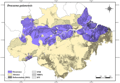
Regional threats. Deforestation of riparian forests and pollution of rivers (widespread species, but usually found in the water and on the margins of rivers, streams, and lakes); commercial use of the animal (or parts of it) in traditional medicines, skin trade, and for food.
Conservation status. LC (Least Concern); it is listed in Appendix II [Citation146] of CITES.
Kentropyx Spix.[Citation125]
Kentropyx altamazonica Cope.[Citation82]
Distribution. Brazil, Venezuela, Colombia, Ecuador, Peru, and Bolivia
Extent of occurrence. 1,849,800.06 km2.
Occurrence area. In the Brazilian Amazonia Kentropyx altamazonica has about 49% of its occurrence area inside protected areas, and about 9% of its occurrence area has been deforested (Figure ).
Figure 105. Occurrence area and records of Kentropyx altamazonica in the Brazilian Amazonia, showing the overlap with protected and deforested areas.
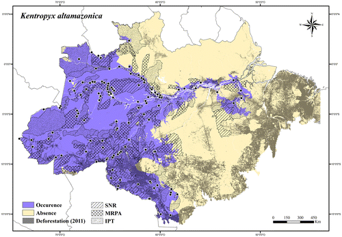
Regional threats. Rapid agricultural expansions (mainly soybean production), expansion of roads and urban areas along the Madeira River and in its southern and eastern occurrence area; expansion of electricity transmission lines, roads, and urban areas along the north side of the middle Amazon River; construction and operation of hydroelectric dams, and infrastructure associated with power stations on the Madeira and Xingu rivers.
Conservation status. LC (Least Concern).
Kentropyx calcarata Spix.[Citation125]
Distribution. Brazil, French Guiana, Suriname, Guyana, and Venezuela.
Extent of occurrence. 2,074,687.51 km2.
Occurrence area. In the Brazilian Amazonia Kentropyx calcara has about 49% of its occurrence area inside protected areas, and about 22% of its occurrence area has been deforested (Figure ).
Figure 106. Occurrence area and records of Kentropyx calcarata in the Brazilian Amazonia, showing the overlap with protected and deforested areas.
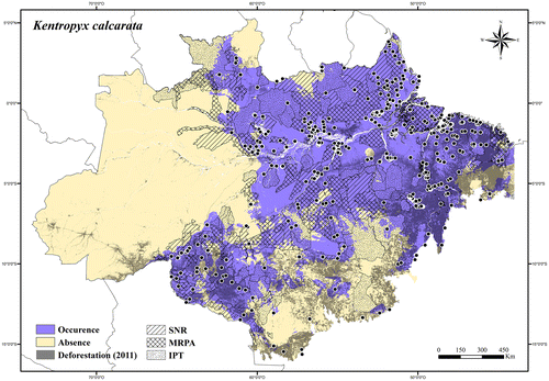
Regional threats. Rapid agricultural expansions (mainly soybean production), expansion of roads and urban areas, clearing for pasture, and fires in its southern occurrence area; expansion of electricity transmission lines, roads, and urban areas along the north side of the Amazon River and the Atlantic coastal region; rapid agricultural expansions, clearing for pasture, and fires in the Lavrado region of Roraima state.
Conservation status. LC (Least Concern).
Kentropyx pelviceps Cope.[Citation90]
Distribution. Brazil, Colombia, Ecuador, Peru, and Bolivia.
Extent of occurrence. 1,169,430.95 km2.
Occurrence area. In the Brazilian Amazonia Kentropyx pelviceps has about 52% of its occurrence area inside protected areas, and about 6% of its occurrence area has been deforested (Figure ).
Figure 107. Occurrence area and records of Kentropyx pelviceps in the Brazilian Amazonia, showing the overlap with protected and deforested areas.
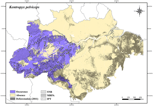
Regional threats. Rapid agricultural expansions (mainly soybean production), expansion of roads and urban areas along the Madeira River and in its southern occurrence area.
Conservation status. LC (Least Concern).
Kentropyx striata (Daudin).[Citation176]
Distribution. Brazil, Suriname, Guyana, Venezuela, and Trinidad and Tobago.
Extent of occurrence. 92,820.44 km2.
Occurrence area. In the Brazilian Amazonia Kentropyx striata has about 42% of its occurrence area inside protected areas, and at least 9% of its occurrence area has been degraded (Figure ).
Figure 108. Occurrence area and records of Kentropyx striata in the Brazilian Amazonia, showing the overlap with protected and deforested areas.
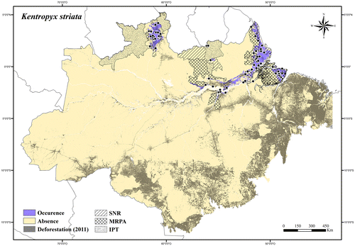
Regional threats. Expansion of roads and urban areas in Marajó Island and along the lower Tapajós River; expansion of electricity transmission lines, roads, and urban areas along the Amazon River and the Atlantic coastal region; rapid agricultural expansion, clearing for pasture, and fire in the Lavrado region of Roraima state.
Conservation status. LC (Least Concern).
Kentropyx vanzoi Gallagher & Dixon.[Citation177]
Distribution. Brazil and Bolivia.
Extent of occurrence. 30,543.51 km2.
Occurrence area. In the Brazilian Amazonia Kentropyx vanzoi has about 21% of its occurrence area inside protected areas, and at least 34% of its occurrence area has been degraded (Figure ).
Figure 109. Occurrence area and records of Kentropyx vanzoi in the Brazilian Amazonia, showing the overlap with protected and deforested areas.
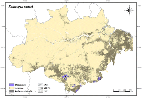
Regional threats. Rapid agricultural expansions (mainly soybean production), expansion of roads and urban areas, clearing for pasture, and fires.
Conservation status. VU A2c (Vulnerable); it was listed in the Brazilian Red List of Threatened Species [Citation73] as VU A2c.
Salvator Duméril & Bibron.[Citation107]
Salvator merianae Duméril & Bibron.[Citation107]
Distribution. Brazil, Bolivia, Paraguay, Argentina, and Uruguay.
Extent of occurrence. 368,975.76 km2.
Occurrence area. In the Brazilian Amazonia Salvator merianae has about 18% of its occurrence area inside protected areas, and at least 51% of its occurrence area has been degraded (Figure ).
Figure 110. Occurrence area and records of Salvator merianae in the Brazilian Amazonia, showing the overlap with protected and deforested areas.
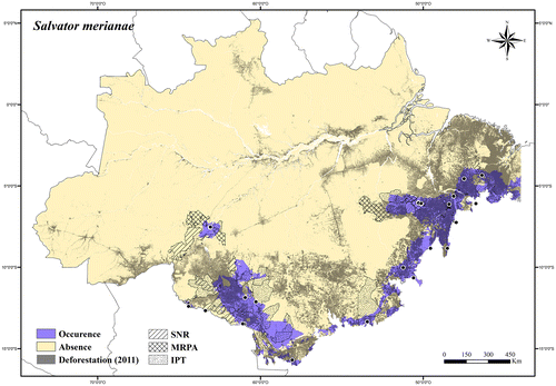
Regional threats. Rapid agricultural expansions (mainly soybean production), expansion of roads and urban areas, clearing for pasture, and fires; commercial use of the animal (or parts of it) in traditional medicines, skin trade, and for food.
Conservation status. NT (Near Threatened); it was listed in the IUCN Red List [Citation75] as LC (Least Concern); all Salvator species are included in Appendix II [Citation146] of CITES.
Tupinambis Daudin.[Citation176]
Tupinambis longilineus Ávila-Pires.[Citation8]
Distribution. Brazil and Peru.
Extent of occurrence. 29,287.46 km2.
Occurrence area. In the Brazilian Amazonia Tupinambis longilineus has about 52% of its occurrence area inside protected areas, and about 16% of its occurrence area has been deforested (Figure ).
Figure 111. Occurrence area and records of Tupinambis longilineus in the Brazilian Amazonia, showing the overlap with protected and deforested areas.
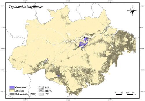
Regional threats. Rapid agricultural expansions (mainly soybean production), expansion of roads and urban areas in its southern and western occurrence area; mining activities and expansion of roads in its northeastern occurrence area; commercial use of the animal (or parts of it) in traditional medicines, skin trade, and for food.
Conservation status. LC (Least Concern); all Tupinambis species are included in Appendix II [Citation146] of CITES.
Tupinambis quadrilineatus Manzani & Abe.[Citation178]
Distribution. Endemic to Brazil.
Extent of occurrence. 16,968.23 km2.
Occurrence area. In the Brazilian Amazonia Tupinambis quadrilineatus has about 2% of its occurrence area inside protected areas, and at least 75% of its occurrence area has been degraded (Figure ).
Figure 112. Occurrence area and records of Tupinambis quadrilineatus in the Brazilian Amazonia, showing the overlap with protected and deforested areas.
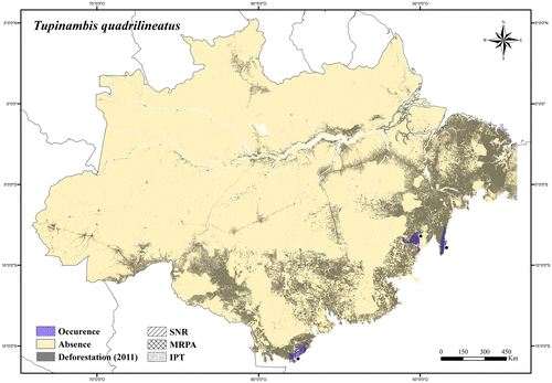
Regional threats. Rapid agricultural expansions (mainly soybean production), expansion of roads and urban areas, clearing for pasture, and fires; commercial use of the animal (or parts of it) in traditional medicines, skin trade, and for food.
Conservation status. VU A2c (Vulnerable); all Tupinambis species are included in Appendix II [Citation146] of CITES.
Tupinambis teguixin (Linnaeus).[Citation100]
Distribution. Panama, Trinidad and Tobago, Brazil, French Guiana, Suriname, Guyana, Venezuela, Colombia, Ecuador, Peru, and Bolivia.
Extent of occurrence. 3,663,859.84 km2.
Occurrence area. In the Brazilian Amazonia Tupinambis teguixin has about 49% of its occurrence area inside protected areas, and about 17% of its occurrence area has been deforested (Figure ).
Figure 113. Occurrence area and records of Tupinambis teguixin in the Brazilian Amazonia, showing the overlap with protected and deforested areas.
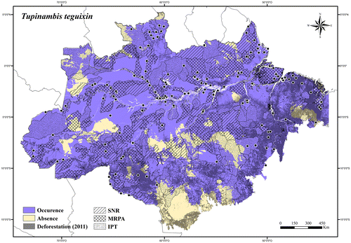
Regional threats. Deforestation (widespread species); commercial use of the animal (or parts of it) in traditional medicines, skin trade, and for food.
Conservation status. LC (Least Concern); all Tupinambis species are included in Appendix II [Citation146] of CITES.
Tupinambis sp.
Distribution. Endemic to Brazil.
Extent of occurrence. 468,613.92 km2.
Occurrence area. In the Brazilian Amazonia Tupinambis sp. has about 19% of its occurrence area inside protected areas, and at least 38% of its occurrence area has been degraded (Figure ).
Figure 114. Occurrence area and records of Tupinambis sp. in the Brazilian Amazonia, showing the overlap with protected and deforested areas.
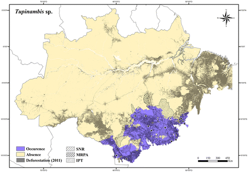
Regional threats. Rapid agricultural expansions (mainly soybean production), expansion of roads and urban areas, clearing for pasture, and fires; commercial use of the animal (or parts of it) in traditional medicines, skin trade, and for food.
Conservation status. NT (Near Threatened); all Tupinambis species are included in Appendix II [Citation146] of CITES.
Tropiduridae
Plica Gray.[Citation80]
Plica plica (Linnaeus).[Citation100]
Distribution. Trinidad and Tobago, Brazil, French Guiana, Suriname, Guyana, Venezuela, Colombia, Ecuador, Peru, and Bolivia.
Extent of occurrence. 3,370,299.3 km2.
Occurrence area. In the Brazilian Amazonia Plica plica has about 54% of its occurrence area inside protected areas, and about 12% of its occurrence area has been deforested (Figure ).
Figure 115. Occurrence area and records of Plica plica in the Brazilian Amazonia, showing the overlap with protected and deforested areas.
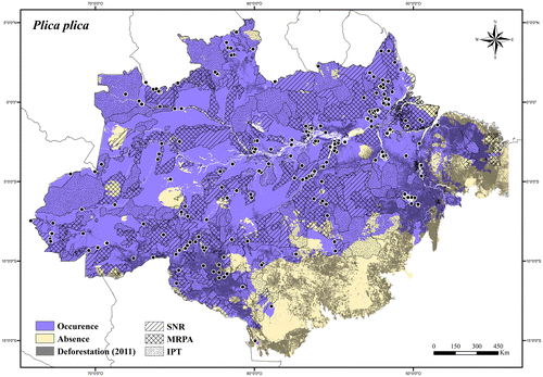
Regional threats. Deforestation (widespread species).
Conservation status. LC (Least Concern).
Plica umbra (Linnaeus).[Citation100]
Plica umbra umbra (Linnaeus).[Citation100]
Distribution. Brazil, French Guiana, Suriname, Guyana, and Venezuela.
Extent of occurrence. 622,081.8 km2.
Occurrence area. In the Brazilian Amazonia Plica umbra umbra has about 58% of its occurrence area inside protected areas, and about 5% of its occurrence area has been deforested (Figure ).
Figure 116. Occurrence area and records of Plica umbra umbra in the Brazilian Amazonia, showing the overlap with protected and deforested areas.
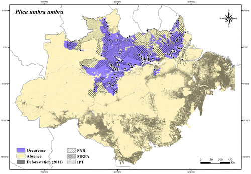
Regional threats. Expansion of electricity transmission lines, roads, and urban areas along the Amazon River; expansion of roads and urban areas along the lower Madeira and Tapajós rivers.
Conservation status. LC (Least Concern).
Plica umbra ochrocollaris (Spix).[Citation125]
Distribution. Brazil, Venezuela, Colombia, Ecuador, Peru, and Bolivia.
Extent of occurrence. 2,047,457.99 km2.
Occurrence area. In the Brazilian Amazonia Plica umbra ochrocollaris has about 45% of its occurrence area inside protected areas, and about 16% of its occurrence area has been deforested (Figure ).
Figure 117. Occurrence area and records of Plica umbra ochrocollaris in the Brazilian Amazonia, showing the overlap with protected and deforested areas.
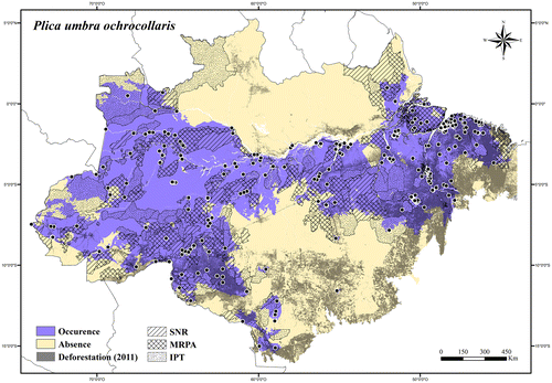
Regional threats. Rapid agricultural expansions (mainly soybean production), expansion of roads and urban areas, clearing for pasture, and fires along its southern occurrence area, and along the Madeira and Tapajós rivers; expansion of roads and urban areas, clearing for pasture, and fires in its eastern occurrence area.
Conservation status. LC (Least Concern).
Plica umbra ssp.
Distribution. Brazil, Ecuador, and Peru.
Extent of occurrence. 13,255.04 km2.
Occurrence area. In the Brazilian Amazonia Plica umbra ssp. has about 44% of its occurrence area inside protected areas, and about 1% of its occurrence area has been degraded (Figure ).
Figure 118. Occurrence area and records of Plica umbra ssp. in the Brazilian Amazonia, showing the overlap with protected and deforested areas.

Regional threats. Expansion of roads and urban areas in its southern occurrence area.
Conservation status. LC (Least Concern).
Stenocercus Duméril & Bibron.[Citation84]
Stenocercus albolineatus Teixeira et al. [Citation179]
Distribution. Endemic to Brazil.
Extent of occurrence. 84,350.08 km2.
Occurrence area. In the Brazilian Amazonia Stenocercus albolineatus has about 42% of its occurrence area inside protected areas, and at least 16% of its occurrence area has been degraded (Figure ).
Figure 119. Occurrence area and records of Stenocercus albolineatus in the Brazilian Amazonia, showing the overlap with protected and deforested areas.
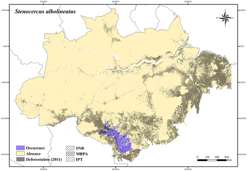
Regional threats. Rapid agricultural expansions (mainly soybean production), expansion of roads and urban areas, clearing for pasture, and fires.
Conservation status. LC (Least Concern).
Stenocercus dumerilii (Steindachner).[Citation180]
Distribution. Endemic to Southern Brazilian Amazonia.
Extent of occurrence. 59,170.75 km2.
Occurrence area. In the Brazilian Amazonia Stenocercus dumerilii has about 6% of its occurrence area inside protected areas, and about 75% of its occurrence area has been deforested (Figure ).
Figure 120. Occurrence area and records of Stenocercus dumerilii in the Brazilian Amazonia, showing the overlap with protected and deforested areas.

Regional threats. Expansion of roads, urban areas, clearing for pasture, fires, mining activities, and logging inside protected areas.
Conservation status. VU A2c (Vulnerable); it was listed in the Red List of Threatened Species of the Pará state,[Citation74] Brazil; it was listed in the Brazilian Red List of Threatened Species [Citation73] as VU A2c.
Stenocercus fimbriatus Ávila-Pires.[Citation8]
Distribution. Brazil and Peru.
Extent of occurrence. 288,442.77 km2.
Occurrence area. In the Brazilian Amazonia Stenocercus fimbriatus has about 56% of its occurrence area inside protected areas, and about 3% of its occurrence area has been deforested (Figure ).
Figure 121. Occurrence area and records of Stenocercus fimbriatus in the Brazilian Amazonia, showing the overlap with protected and deforested areas.
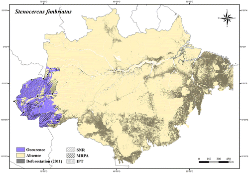
Regional threats. Expansion of roads and urban areas in its southern occurrence area.
Conservation status. LC (Least Concern).
Stenocercus roseiventris Duméril & Bibron.[Citation84]
Distribution. Brazil, Peru, and Bolivia.
Extent of occurrence. 144,566.53 km2.
Occurrence area. In the Brazilian Amazonia Stenocercus roseiventris has about 47% of its occurrence area inside protected areas, and about 6% of its occurrence area has been deforested (Figure ).
Figure 122. Occurrence area and records of Stenocercus roseiventris in the Brazilian Amazonia, showing the overlap with protected and deforested areas.
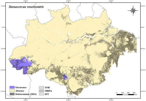
Regional threats. Expansion of roads and urban areas in its western occurrence area; rapid agricultural expansions (mainly soybean production), expansion of roads and urban areas, clearing for pasture, and fires in its eastern occurrence area.
Conservation status. LC (Least Concern).
Tropidurus Wied.[Citation181]
Tropidurus hispidus (Spix).[Citation125]
Distribution. Brazil, Suriname, Guyana, Venezuela, and Colombia.
Extent of occurrence. 184,158.2 km2.
Occurrence area. In the Brazilian Amazonia Tropidurus hispidus has about 25% of its occurrence area inside protected areas, and at least 52% of its occurrence area has been degraded (Figure ).
Figure 123. Occurrence area and records of Tropidurus hispidus in the Brazilian Amazonia, showing the overlap with protected and deforested areas.
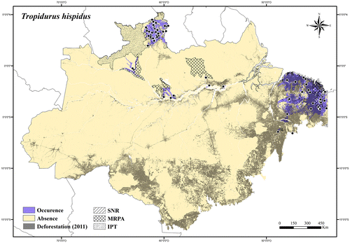
Regional threats. Expansion of electricity transmission lines, roads, and urban areas along the Amazon River; rapid agricultural expansion, clearing for pasture, and fires in the Lavrado region of Roraima state; Expansion of roads, urban areas, clearing for pasture, fires, and mining activities in its eastern occurrence area.
Conservation status. NT (Near Threatened).
Tropidurus insulanus Rodrigues.[Citation182]
Distribution. Endemic to Brazil.
Extent of occurrence. 27,679.41 km2.
Occurrence area. In the Brazilian Amazonia Tropidurus insulanus has about 38% of its occurrence area inside protected areas, and at least 22% of its occurrence area has been degraded (Figure ).
Figure 124. Occurrence area and records of Tropidurus insulanus in the Brazilian Amazonia, showing the overlap with protected and deforested areas.
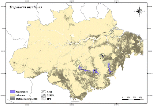
Regional threats. Rapid agricultural expansions (mainly soybean production), expansion of roads and urban areas, clearing for pasture, and fires.
Conservation status. LC (Least Concern).
Tropidurus oreadicus Rodrigues.[Citation182]
Distribution. Endemic to Brazil.
Extent of occurrence. 744,673.07 km2.
Occurrence area. In the Brazilian Amazonia Tropidurus oreadicus has about 38% of its occurrence area inside protected areas, and at least 37% of its occurrence area has been degraded (Figure ).
Figure 125. Occurrence area and records of Tropidurus oreadicus in the Brazilian Amazonia, showing the overlap with protected and deforested areas.
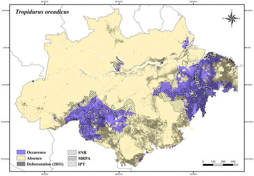
Regional threats. Rapid agricultural expansions (mainly soybean production), expansion of roads and urban areas, clearing for pasture, and fires in its western occurrence area; expansion of roads and urban areas, clearing for pasture, fires, and mining activities in its eastern occurrence area.
Conservation status. LC (Least Concern).
Uracentron Kaup.[Citation183]
Uracentron azureum (Linnaeus).[Citation100]
Uracentron azureum azureum (Linnaeus).[Citation100]
Distribution. Brazil, French Guiana, and Suriname.
Extent of occurrence. 648,196.1 km2.
Occurrence area. In the Brazilian Amazonia Uracentron azureum azureum has about 45% of its occurrence area inside protected areas, and about 15% of its occurrence area has been deforested (Figure ).
Figure 126. Occurrence area and records of Uracentron azureum azureum in the Brazilian Amazonia, showing the overlap with protected and deforested areas.
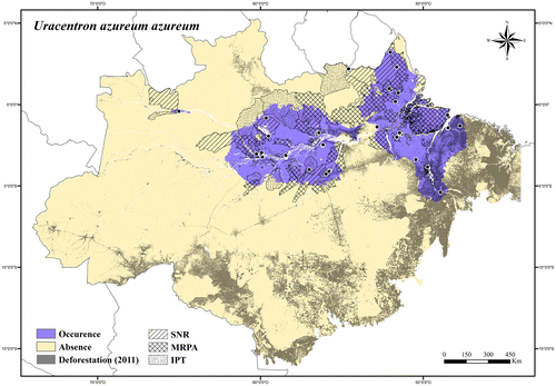
Regional threats. Expansion of electricity transmission lines, roads, and urban areas along the Amazon River and Atlantic coastal region; expansion of roads, clearing for pasture, and fires along the lower Tapajós and Xingu rivers, in the Marajó Island, and in its southeastern occurrence area; construction and operation of hydroelectric dams, and infrastructure associated with power stations on the Tapajós, Xingu, Trombetas, and Jari rivers.
Conservation status. LC (Least Concern).
Uracentron azureum guentheri Boulenger.[Citation184]
Distribution. Brazil and Peru.
Extent of occurrence. 400,491.14 km2.
Occurrence area. In the Brazilian Amazonia Uracentron azureum guentheri has about 43% of its occurrence area inside protected areas, and about 4% of its occurrence area has been deforested (Figure ).
Figure 127. Occurrence area and records of Uracentron azureum guentheri in the Brazilian Amazonia, showing the overlap with protected and deforested areas.
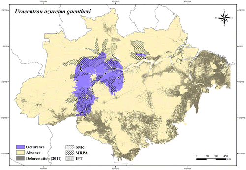
Regional threats. Expansion of electricity transmission lines, roads, and urban areas along the north side of the Amazon River; construction and operation of hydroelectric dams, and infrastructure associated with power stations on the Trombetas River; rapid agricultural expansion (mainly soybean production), expansion of roads and urban areas, and fires in its southwestern occurrence area.
Conservation status. LC (Least Concern).
Uracentron azureum werneri Mertens.[Citation185]
Distribution. Brazil, Venezuela, and Colombia.
Extent of occurrence. 594,077.03 km2.
Occurrence area. In the Brazilian Amazonia Uracentron azureum werneri has about 52% of its occurrence area inside protected areas, and less than 1% of its occurrence area has been deforested (Figure ).
Figure 128. Occurrence area and records of Uracentron azureum werneri in the Brazilian Amazonia, showing the overlap with protected and deforested areas.
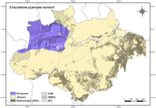
Regional threats. No current or potential threats in its occurrence area.
Conservation status. LC (Least Concern).
Uracentron flaviceps (Guichenot).[Citation142]
Distribution. Brazil, Colombia, Ecuador, and Peru.
Extent of occurrence. 1,189,404.93 km2.
Occurrence area. In the Brazilian Amazonia Uracentron flaviceps has about 52% of its occurrence area inside protected areas, and about 5% of its occurrence area has been deforested (Figure ).
Figure 129. Occurrence area and records of Uracentron flaviceps in the Brazilian Amazonia, showing the overlap with protected and deforested areas.
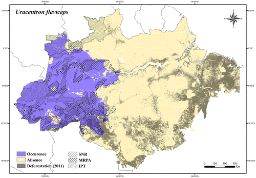
Regional threats. Rapid agricultural expansion, fires, expansion of roads and urban areas in its southeastern occurrence area.
Conservation status. LC (Least Concern).
Uranoscodon Kaup.[Citation186]
Uranoscodon superciliosus (Linnaeus).[Citation100]
Distribution. Brazil, French Guiana, Suriname, Venezuela, Colombia, and Bolivia
Extent of occurrence. 2,398,515.99 km2.
Occurrence area. In the Brazilian Amazonia Uranoscodon superciliosus has about 48% of its occurrence area inside protected areas, and about 14% of its occurrence area has been deforested (Figure ).
Figure 130. Occurrence area and records of Uranoscodon superciliosus in the Brazilian Amazonia, showing the overlap with protected and deforested areas.
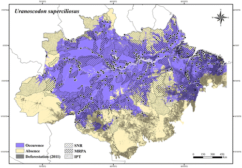
Regional threats. Deforestation of riparian forests and pollution of rivers (widespread species, but usually found in the water and on the margins of rivers, streams, and lakes); commercial use of the animal (or parts of it) in traditional medicines.
Conservation status. LC (Least Concern).
General patterns of species distribution
After summarizing the occurrence data, five main patterns of geographical distribution were found, plus some cases of unique distributions: 15 taxa are distributed in Eastern Amazonia, 19 in Western Amazonia, 22 in Northern Amazonia, 50 in Southern Amazonia, 24 are widespread species, and seven presented Unique Distribution (Table ; Figures –). Some species have their distribution mostly in, but not restricted to, some region: Anolis bombiceps has its distribution mostly in Northwestern Amazonia, but also occurs in the Juruá–Purus Interfluvium (Figure ); Bachia panoplia has most of its distribution in the southern portion of Northern Amazonia, but is also found in the lower Tapajós river system (Figure ); Thecadactylus rapicauda has its distribution mostly in Eastern Amazonia, but also occurs in lower Japurá and Purus river systems in Western Amazonia (Figure ); Kentropyx altamazonica and Uracentron azureum guentheri have their main distribution in Western Amazonia, but also occur in the Branco and Xingu river systems, and in the lower Trombetas river system, respectively (Figures and ); Plica umbra umbra is widely distributed in Northern Amazonia, but also occurs in the lower river systems of the Japurá, Madeira, Tapajós, and Xingu (Figure ).
Table 2. General patterns of species distribution in the Brazilian Amazonia.
In Northern Amazonia, six regional patterns were found: six taxa are distributed in the eastern portion of the region, five taxa in the western portion, one in central portion, four in northern portion, four in the southern portion, and two taxa are widely distributed in the northern region (Table ). In Southern Amazonia, five regional patterns were found: four taxa are distributed in the eastern portion of the region, 10 in the western portion, 14 in the central portion, 20 in the peripheral southern portion, and two are widely distributed in the Southern Amazonia (Table ). Gonatodes eladioi has its distribution mostly in the Southeastern Amazonia, but also in the upper Tapajós river system (Figure ); Gonatodes hasemani in the Southwestern Amazonia, but also in Xingu river system (Figure ); Tupinambis longilineus in the central portion of Southern Amazonia, but also in the middle Purus river system (Figure ); Plica umbra ochrocollaris and Tropidurus oreadicus are widely distributed in the Southern Amazonia, but also in some areas in Northern Amazonia (Figures and ).
Seven other taxa present unique distributions: Anolis trachyderma and Potamites ecpleopus have disjunct distributions in Western and Eastern Amazonia (Figures and ); Tretioscincus oriximinensis has disjunct distribution in the northwestern and southeastern portions of Northern Amazonia and in Purus–Madeira Interfluvium in Southern Amazonia (Figure ); Hemidactylus palaichthus is distributed along the Negro River, in the northern portion of Northern Amazonia, and in the Madeira river system in Southern Amazonia (Figure ); Enyalius leechii is widely distributed in Southern Amazonia, except in the westernmost portion of this region (Figure ); Leposoma ferreirai has an insular distribution, only found in the Anavilhanas Archipelago (Figure ); and Marinussaurus curupira restricted to a peninsular region between the Negro and Amazon rivers. Hemidactylus mabouia was not considered here because it is an introduced species.
Species richness
Up to 44 taxa were recorded in a single grid in the Brazilian Amazonia. In northern Amazonia, the highest values (37–44 taxa) were found in the Guiana region (in the eastern portion, and along the lower courses of the Trombetas and Negro Rivers), and along the lower Japurá River. In Southern Amazonia, the same values were found along the middle Tapajós River (on the left side), along the middle-upper Madeira River (mainly on the left side), along part of the upper Amazon River, and in upper Juruá River (Figure ). Almost all the southern Guiana region, the northern area between the Tocantins River and Atlantic coastal region (extreme eastern Amazonia), Carajás region (upper lands in southeastern Amazonia), lower Xingu River, middle and lower Tapajós River, lower Madeira River, and the upper part of the Javari and Juruá rivers (close to the Peru/Colombia border) presented between 30 and 36 taxa (Figure ). On the other hand, the lowest values of species richness (up to six taxa) were found in the central portion of the Amazonia–Cerrado transition area (in Southern Amazonia), and on the northernmost border (Venezuela and Brazil – Roraima state frontier; Figure ).
Figure 131. Distribution of species richness of lizards in the Brazilian Amazonia, showing the overlap with strict nature reserves (SNR).
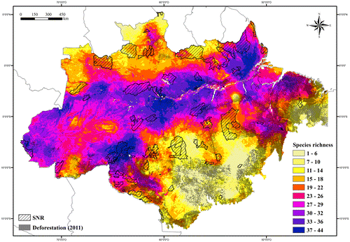
Discussion
Species diversity
Ávila-Pires [Citation8] listed 95 species and two species complexes from the Brazilian Amazonia. In our study, we listed 43 additional taxa, 138 in total. Species diversity has increased by more than 45% since the last revision. Rodrigues [Citation187] suggested that the diversity of Amazonian lizards has been underestimated, even when considering the fact that the region presents the highest lizard diversity among the Brazilian biomes. The recognition of new taxa and new records for the region (mainly in the Amazonian southern border) are the main reasons for this increase in species diversity. Of the 43 additional taxa, 15 were described in the last two decades (Bachia didactyla, B. pyburni, B. remota, B. scaea, Gymnophtalmus vanzoi, Leposoma ferreirai, Marinussaurus curupira, Potamites juruazensis, Rondonops biscutatus, R. xanthomystax, Varzea altamazonica, Gonatodes nascimentoi, Pseudogonatodes gasconi, Thecadactylus solimoensis, Ameiva parecis); 13 were new records in Southern Amazonia (Anolis meridionalis, Bachia scolecoides, Cercosaura schreibersii, Micrablepharus atticolus, Rhachisaurus brachylepis, Manciola guaporicola, Notomabuya frenata, Coleodactylus meridionalis, Gymnodactylus amarali, Phyllopezus pollicaris, Kentropyx vanzoi, Tupinambis quadrilineatus, Stenocercus albolineatus); two were new records in Western Amazonia (Anolis dissimilis, Iphisa elegans soinii); eleven were recognized as new undescribed taxa (four in Cercosaura, two in Cnemidophorus, and one in Gymnophthalmus, Leposoma, Cnemidophorus, Plica, and Tupinambis); and two were cited by Ávila-Pires [Citation8] under species complexes (Cnemidophorus cryptus, under lemniscatus complex; Gymnophthalmus leucomystax, under underwoodi complex). As is typical in remote areas, of the 15 additional taxa described in the last 20 years, twelve were the result of new species discovery by recent field campaigns. Our results demonstrate that those species also have a restricted distribution, confirmed in the region where the type-locality is included, and/or in areas with similar habitats to where it was found for the first time (e.g. Bachia pyburni was restricted to some upper lands in northwestern Amazonia; Leposoma ferreirai was only found on the Anavilhanas archipelago; Ameiva parecis was restricted to open vegetation enclaves in Southern Amazonia). Hubbell [Citation188] has already pointed to the high number of species with restricted distribution in tropical forests, and the great influence of those species as being responsible for the high species diversity found in Amazonia.
The lack of knowledge about the species diversity in Amazonia is also demonstrated by the high rate of new records obtained from the southern Brazilian Amazonia, traditionally the portion of the forest most exploited by human activities. The new occurrences in this region were obtained mainly from the open vegetation enclaves and patches of dry forests in the transition of Amazonia with Cerrado. From these areas, we found 11 of the 30 species recognized by Silva et al. [Citation189] to be endemic to Brazilian Cerrado (about one third of Silva’s list), showing that a lack of knowledge still had remained for Southern Amazonia, and that there is an overestimated rate of endemicity for the Brazilian Cerrado. In addition, some taxa mentioned in our study are in fact composed of cryptic undescribed species, as documented for Ameiva ameiva,[Citation190] Anolis meridionalis,[Citation191] Chatogekko amazonicus,[Citation159,192,193] Copeoglossum nigropunctatum,[Citation194] Iphisa elegans elegans,[Citation195] Plica plica,[Citation196] Tropidurus oreadicus (2011 personal communication with G. Colli; unreferenced), and Alopoglossus angulatus (under description by MAR-J). Thus, with the increasing of taxonomic research, the diversity of the Amazonian lizards will increase as well.
The most diverse family in the Brazilian Amazonia is Gymnophthalmidae (n = 52 ssp.), as supported by Ávila-Pires [Citation8], and the Dactyloidae family contains the genus with the highest number of species (Anolis; n = 16). Gymnophthalmidae is an endemic species of the Neotropical region,[Citation197] and Anolis is one of the largest genera of vertebrates, but with more than 50% of the described species occurring outside Amazonia (the highest number of species is on the Caribbean Islands; see [Citation198]). On the other hand, three families (Anguidae, Iguanidae, and Leiosauridae) and 18 genera of other families have only one species occurring in the Brazilian Amazonia. Amapasaurus, Colobosaura, Marinussaurus, Hoplocercus, Exila, Manciola, Notomabuya, Chatogekko, Crocodilurus, and Uranoscodon are monospecific genera, and, with the exception of Marinussaurus, Notomabuya, Gymnodactylus, and Phyllopezus, all others were already mentioned by Ávila-Pires [Citation8] as being present in the region (Exila and Manciola as Mabuya, and Chatogekko as Coleodactylus).
Of the 138 taxa recorded in the Brazilian Amazonia, 104 are also found in other countries, with most of the species also occurring in the Amazonian portion of those countries. So, the proportion of Brazilian endemic species is about 25%. If we consider endemicity for only the Brazilian Amazonia, the rate decreases to about 16%. Ávila-Pires et al. [Citation199] reported an endemicity range of 77–80% for Amazonian lizards as a whole, whilst in this study the same rate reaches 69%. The high number of new additional records in the Amazonia–Cerrado transition area was the main reason for the decrease in this rate.
General patterns of species distribution
Ávila-Pires [Citation8] reported seven general patterns of lizard distribution, plus some species with unique distributions [1. widespread (n = 7 spp.); 2. widespread, except for some western areas (n = 10 spp.); 3. Eastern Amazonia (n = 7 spp.); 4. Northern Amazonia (n = 13 spp.); 5. Western Amazonia (n = 13 spp.); 6. Southwestern Amazonia (n = 13 spp.); 7. Peripheral in the southeastern Amazonia (n = 9 spp.); 8. Others, which included mostly widespread, following main rivers, unique distribution, and species only known from one or few localities and/or specimens (n = 22 spp.)]. We have considered five main general patterns of distribution (Widespread, Eastern Amazonia, Western Amazonia, Northern Amazonia, and Southern Amazonia), plus Unique Distributions (other types of distribution observed besides the patterns mentioned above), and 11 regional distribution patterns (six in Northern Amazonia and five in Southern Amazonia). We recognized Southern Amazonia as a general pattern of distribution, and the regionalization of the Northern and Southern general patterns (except Southwestern Amazonia) not considered before by Ávila-Pires [Citation8].
Some modifications, considering the general patterns of lizard distribution recognized by Ávila-Pires [Citation8], were proposed here. Of the seven species considered to be Widespread by Ávila-Pires [Citation8] (Iguana iguana, Anolis fuscoauratus, Thecadactylus rapicauda, Gonatodes humeralis, Ameiva ameiva, Tupinambis teguixin, and Copeoglossum nigropunctatum), T. rapicauda was considered by us as having an Eastern Amazonia pattern, due to its absence in most of Western Amazonia. All species considered Widespread, except for some western areas, by Ávila-Pires [Citation8] (n = 10; Anolis punctatus, A. ortonii, Alopoglossus angulatus, Arthrosaura reticulata, Uranoscodon superciliosus, Coleodactylus amazonicus, Bachia flavescens, Leposoma percarinatum, Polychrus marmoratus, and Iphisa elegans elegans) were considered in our study to be Widespread, due to their occurrence in all main/general patterns of distribution. Besides these, we recognized as Widespread: Cercosaura argulus, Ptychoglossus brevifrontalis, Varzea bistriata, Lepidoblepharus heyerorum, Pseudogonatodes guianensis, Crocodilurus amazonicus, Dracaena guianensis, and Plica plica. Cercosaura argulus was not considered in the distribution pattern section by Ávila-Pires [Citation8] (the reason was not provided by the author in the study); the other species were considered by Ávila-Pires [Citation8] as having Unique Distributions (see [Citation8, p.602–603]).
We recognized in our study the same seven taxa included in Eastern Amazonia by Ávila-Pires [Citation8] (Neusticurus bicarinatus, Kentropyx calcarata, Cercosaura ocellata ocellata, Uracentron azureum azureum, Arthrosaura kockii, Leposoma guianense, and Tretioscincus agilis). Besides them, we considered Anolis auratus, Gymnophthalmus sp., Thecadactylus rapicauda, Gonatodes nascimentoi, Cnemidophorus cryptus, Cnemidophorus lemniscatus, Kentropyx striata, and Tropidurus hispidus as having an Eastern Amazonia distribution, even though Ávila-Pires [Citation8] had considered: A. auratus, K. striata, and Gymnophthalmus sp. (inside G. underwoodi complex) as having a Northern Distribution; C. cryptus and C. lemniscatus (inside C. lemniscatus complex), and T. hispidus as having Unique Distributions; and T. rapicauda as Widespread (see above). All of these taxa are distributed on both sides of the Amazon River in Eastern Amazonia, and for that reason we considered them as having an Eastern Amazonia distribution. Gonatodes nascimentoi, not mentioned by Ávila-Pires [Citation8], was recently described. Ávila-Pires [Citation8] considered another 11 taxa as having a Northern Distribution (n = 14; Plica umbra umbra, Gonatodes annularis, Neusticurus racenisi, N. rudis, Anolis chrysolepis, A. planiceps, Hemidactylus palaichthus, Coleodactylus septentrionalis, Tretioscincus oriximinensis, Panopa carvalhoi, and Uracentron azureum werneri). We recognized the same distribution pattern for Gymnophthalmus leucomystax, G. underwoodi, G. vanzoi (all under G. underwoodi complex in [Citation8]), Anolis chrysolepis, A. planiceps, Neusticurus racenisi, N. rudis, Panopa carvalhoi, Coleodactylus septentrionalis, Gonatodes annularis, and Plica umbra umbra (despite its occurrence in some areas in Southern Amazonia). We recognized Hemidactylus palaichthus and T. oriximinensis as having Unique Distributions because of their disjunct distribution in Northern Amazonia and Southern Amazonia, and Uracentron azureum werneri as having a Western Distribution. Anolis bombiceps, A. philopunctatus, A. scypheus, Amapasaurus tetradactylus, Bachia panoplia, B. pyburni, Bachia sp., Cercosaura sp. 3, Cnemidophorus sp. 2, Cnemidophorus sp. 3, and Leposoma sp., were the other taxa recognized by us as having a Northern Amazonia Distribution (22 taxa in total).
Thirteen taxa were considered by Ávila-Pires [Citation8] as having a Western Distribution (Enyalioides laticeps, Anolis bombiceps, A. scypheus, A. tandai, A. transversalis, Uracentron azureum guentheri, U. flaviceps, Alopoglossus atriventris, A. buckleyi, Cercosaura ocellata bassleri, Leposoma parietale, L. snethlageae, and Kentropyx pelviceps), but we recognized the same distribution pattern for nine only (A. tandai, A. transversalis, A. atriventris, C. o. bassleri, L. snethlageae, E. laticeps, K. pelviceps, U. a. guentheri, U. flaviceps). Anolis bombiceps and A. scypheus, as described above, were considered by us as having a Northern Distribution, and L. parietale and A. buckleyi were not considered by us because they do not occur in the Brazilian Amazonia. The other taxa considered by our study as having a Western Amazonia Distribution are: Cercosaura oshaughnessyi, Iphisa elegans soinii, Varzea altamazonica, Thecadactylus solimoensis, Lepidoblepharis hoogmoedi, Cnemidophorus sp. 1, Kentropyx altamazonica (despite its occurrence in some areas in Eastern Amazonia), Plica umbra ssp., Stenocercus fimbriatus, and Uracentron azureum werneri; nine taxa in total. Of them, Ávila-Pires [Citation8] considered I. e. soinii and S. fimbriatus as having a Southwestern Distribution; L. hoogmoedi and K. altamazonica as having Unique Distributions; and U. a. werneri as having a Northern Distribution. Cercosaura oshaghnessyi was not considered in the distribution pattern section by Ávila-Pires [Citation8] (the reason was not provided by the author in the study) and Varzea altamazonica and T. solimoensis have only recently been described.
Ávila-Pires [Citation8] recognized 13 taxa as having a Southwestern Amazonia Distribution (Enyalioides palpebralis, Polychrus liogaster, Stenocercus fimbriatus, S. roseiventris, Gonatodes hasemani, Bachia dorbignyi, B. peruana, Iphisa elegans soinii, Leposoma osvaldoi, Cercosaura eigenmanni, C. parkeri, Exila nigropalmata, and Diploglossus fasciatus). Of them, we recognized only seven taxa as presenting the same regionalization of distribution in Southern Amazonia (E. palpebralis, P. liogaster, S. roseiventris, G. hasemani, B. peruana, E. nigropalmata, and D. fasciatus). We considered S. fimbriatus and I. e. soinii as having a Western Distribution (as cited above); B. dorbignyi, L. osvaldoi, C. eigenmanni, and C. parkeri as having a Southern Distribution, but regionalized in the central portion of the Southern Amazonia, not in the western portion. In total, 10 species were recognized by us as having a Southern Distribution regionalized in the western portion of this area (the species cited above and the recently recorded or described species for Brazilian Amazonia: Anolis dissimilis, Potamites juruazensis, and Pseudogonatodes gasconi). Peripheral Southeastern Amazonia is the seventh general pattern of distribution recognized by Ávila-Pires [Citation8], where nine species were included (Hoplocercus spinosus, Anolis brasiliensis, Polychrus acutirostris, Tropidurus insulanus, T. oreadicus, Colobosaura modesta, Micrablepharus maximiliani, Salvator merianae, and Manciola guaporicola). We do not recognize this regionalization of distribution (southeastern peripheral) for any species in Southern Amazonia. However, along the entire border of the Brazilian Amazonia with the Cerrado, we found several species only distributed in this region, and based on them we recognized the Southern Peripheral regionalization in Southern Amazonia. H. spinosus, Anolis brasiliensis, P. acutirostris, C. modesta, M. maximiliani, S. merianae, and M. guaporicola presented this regionalization of distribution (occurring along the entire border, not only in eastern portion). Tropidurus insulanus and T. oreadicus were recognized by us as having a Southern Amazonia Distribution, but occurring respectively, in the central portion and having a wide distribution in the region. Other taxa recognized by us as having a Southern Distribution regionalized in the peripheral portion were: Anolis meridionalis, Bachia didactyla, Cercosaura ocellata ssp., C. schreibersii, Micrablepharus atticolus, Notomabuya frenata, Gymnodactylus amarali, Phyllopezus pollicaris, Ameiva parecis, Kentropyx vanzoi, Tupinambis quadrilineatus, Tupinambis sp., and Stenocercus albolineatus; 20 taxa in total. None of these taxa were mentioned by Ávila-Pires [Citation8] because some of them were only recently described and others are new occurrences in the Brazilian Amazonia, which are presented here for the first time (see above).
Twenty-two taxa were considered by Ávila-Pires [Citation8] as having Unique Distributions (see [Citation8,p.602–603]). Of them, only Anolis trachyderma, Potamites ecpleopus, and Enyalius leechii were recognized by us in the same category. Anolis trachyderma and P. ecpleopus were based on the same reason found in [Citation8] (disjunct distribution in Western and Eastern Amazonia). Enyalius leechii was considered by Ávila-Pires [Citation8] as having a Unique Distribution due to its southeastern distribution, and in our study due to its wide distribution in Southern Amazonia, except in the westernmost portion of this region (west of the Madeira river system). We also included in the Unique Distributions: Hemidactylus palaichthus, which has a disjunct distribution in Northern and Southern Amazonia; Leposoma ferreirai and Marinussaurus curupira, due to their restricted distribution (insular and peninsular, respectively).
The regionalization of the distribution of several taxa in Northern and Southern Amazonia were incongruent with the delimitation of the areas of endemism (AEs) recognized by Silva et al. [Citation200] and Ribas et al. [Citation201] for primates and birds. This raises questions about considering these same AEs for lizards as well. In Northern Amazonia, the lizard distributions seem to be more restricted than that stated by the limits of the AEs recognized in the region, while in Southern Amazonia the lizard distributions seem to be larger than the limits of the AEs. Fouquet et al. [Citation202] also found distinct spatial patterns of amphibian diversification in Northern Amazonia (Guiana region). Thus, we recommend a deeper investigation into the biogeographical patterns of lizard endemism in Amazonia, with a specific analytical approach that tries to clarify the evolution and diversification process of this group in the region.
Species richness
Except for Ávila-Pires [Citation8] and our study, only regional and scattered information is available about the number of lizard species found in the Brazilian Amazonia. Our study presented the first data about β diversity along the Amazonian landscape (Brazilian portion). The number of species varied between one and 44 taxa in a single grid within the Brazilian Amazonia (Figure ). The richest areas are characterized by environmental heterogeneity perceived as a mosaic of forest types and open vegetation enclaves. The large number of plant physiognomies within the forested matrix of the Amazonia ecosystem operate as functional islands (e.g. isolated savannas, white sand campinas, dry deciduous forests), increasing the diversity of habitats, and consequently the species diversity.[Citation203]
The lowest values of species richness – up to three taxa – were found in the Amazonia–Cerrado transition area (mainly in the central portion of the transition area) and on the northern border. The southern Amazonian band coincides approximately with the Brazilian Shield, a region subjected to increased seasonality and covered by forests that present lower canopy height, lower leaf area, and lower above-ground biomass than dense, tall forests in the north.[Citation204–206] Considering that most of the southern band is also poorly sampled, the low number of species can be a result of a less suitable environment for Amazonian lizards, a sampling artifact coupled with the distinctness of this area, or both. The northern border, in contrast, includes both very wet and drier areas (annual rainfall varying from 2000 to 3000 mm; see [Citation205]), harbors a complex mixture of vegetation types, ranging from dense forest to campinarana and savanna, and displays different altitudes, with a few areas reaching more than 1500 m a.s.l. On the assumption that a lower number of species is expected in the more open vegetation environments, the same is not true for the areas covered by dense forest. In this case, for the most northern part of the Brazilian Amazonia, we are most probably dealing with sampling gaps in areas with most distinct characteristics. An increase in sampling efforts along the area will certainly increase lizard species richness, allowing the registering of species that, until now, were only found in areas near the border of the Brazilian Amazonia (e.g. Anolis vaupesianus in Colombia; Arthrosaura tyleri and A. synaptolepis in Venezuela; Arthrosaura hoogmoedi in Guyana).
Habitat loss, protected areas, and conservation status
Effective conservation action requires knowledge of the distribution of threatened species and the threat processes affecting them.[Citation71] Habitat loss and degradation are primary threats to reptile species.[Citation207] Ten lizard species (Anolis brasiliensis, Colobosaura modesta, Notomabuya frenata, Gymnodactylus amarali, Phyllopezus pollicaris, Coleodactylus meridionalis, Tupinambis quadrilineatus, Salvator merianae, Stenocercus dumerilii, and Tropidurus hispidus) presented the highest proportion of habitat loss (≥50%) and the smallest proportion in protected areas (2–25%) within the Brazilian Amazonia (Table ). These species are distributed along the Southern Peripheral Brazilian Amazonia and, except for S. dumerilii, have their main distribution outside Amazonia. Stenocercus dumerilii is endemic to Southeastern Amazonia, and it has 75% of its occurrence area deforested and only about 6% of its occurrence area inside protected areas. It was included in the Red List of Threatened Species of the Pará state,[Citation74] listed in the Brazilian Red List of Threatened Species as Vulnerable (VU A2c),[Citation73] which was put into the same category by us in the regional assessment for the Brazilian Amazonia, following the same criteria: estimation of population decrease is more than 30% over the last ten years, based on a decline in area of occurrence and quality of habitat (VU A2c). The Amazonian populations (or breeding population; see [Citation72]) of Gymnodactylus amarali, Phyllopezus pollicaris, Coleodactylus meridionalis, and Tupinambis quadrilineatus also presented high rates of habitat loss (about 70% of the occurrence area was degraded). Tupinambis quadrilineatus also had a proportion of habitat loss in the Brazilian Cerrado, as analyzed by Silva et al. [Citation189], and the authors also showed that about 50% of its occurrence area to be degraded. Despite these species having their main distributions outside Amazonia (in the Brazilian Cerrado, a global biodiversity hotspot with only 3% of the area covered by SNR [Citation189,208,209]), the isolated patches of savanna in Southern Amazonia, where the populations are found, are inside the Amazon’s ‘arc of deforestation’. Small ranges and narrow niche requirements make species particularly susceptible to anthropogenic threat processes.[Citation71] This region accounted for 85% of all Amazon deforestation from 1996 to 2005,[Citation67] and has been the world’s most active deforestation frontier in recent decades.[Citation210] The populations of those species in Amazonia are severely fragmented, the extent of suitable habitat has already greatly decreased, and will continue to decline. From this, the reduction in species populations is estimated to be at least 30% over the last 10 years. G. amarali, P. pollicaris, Coleodactylus meridionalis, and T. quadrilineatus, were therefore classified by us in a regional assessment for the Brazilian Amazonia as Vulnerable (VU A2c). Anolis brasiliensis, Colobosaura modesta, Notomabuya frenata, Salvator merianae, and Tropidurus hispidus are also restricted, or have the larger portion of its occurrence area reduced to isolated patches of savannas (or dry forests) inside the “arc of deforestation”, presenting a habitat loss of between 52 and 63%. They were evaluated against the IUCN criteria and do not qualify for threatened categories for now (they are close to qualifying as Vulnerable in the near future). Thus, Anolis brasiliensis, Colobosaura modesta, Notomabuya frenata, Salvator merianae, and T. hispidus were assessed as Near Threatened (NT) in the regional assessment, and are dependent on ongoing conservation measures in the Brazilian Amazonia. Anolis brasiliensis and Colobosaura modesta were previously listed in the Red List of Threatened Species of Pará.[Citation74]
Table 3. Percentage of habitat loss and occurrence of each species in protected areas within Brazilian Amazonia.
Twelve taxa (Anolis meridionalis, Cercosaura ocellata ssp., Cercosaura schreibersii, Micrablepharus atticolus, Micrablepharus maximiliani, Manciola guaporicola, Polychrus acutirostris, Gonatodes eladioi, Cnemidophorus cryptus, Tupinambis sp., Kentropyx vanzoi, and T. oreadicus) suffered more than a 1/3 (≥33%) loss to their habitat, and presented only between 15 and 37% of their occurrence area inside protected areas. Of them, Cnemidophorus cryptus and T. oreadicus are not restricted to Southern Amazonia. Gonatodes eladioi, an endemic species to Southern Amazonia, presented about 36% of habitat loss, and has about 53% of its occurrence area under protection. Kentropyx vanzoi, Anolis meridionalis, Manciola guaporicola, and Micrablepharus atticolus were also analyzed by Silva et al. [Citation189], presenting a degraded occurrence area of between 49% and 59% in the Brazilian Cerrado. Kentropyx vanzoi was listed in the Brazilian Red List of Threatened species as Vulnerable,[Citation73] following the reduction in population size criteria based on declines in areas of occupancy (VU A2c). Despite K. vanzoi having a habitat loss of 34% in the Brazilian Amazonia, its occurrence area is currently decreasing in neighboring regions (49% of habitat loss in the Brazilian Cerrado; see [Citation189]), so downlisting the category of it for a regional assessment may not be appropriate.[Citation72] Since Southern Amazonia is severe threatened by human activity (soy plantation, pastures, fires, and road expansion; [Citation206,211–217]), the endemic Amazonian species and the Amazonian populations of the non-endemic species that occur only in this region (mentioned above) are also severely threatened. Thus, we evaluated A. meridionalis, C. ocellata ssp., C. schreibersii, M. atticolus, M. maximiliani, M. guaporicola, P. acutirostris, G. eladioi, and Tupinambis sp. as Near Threatened (NT) in the regional assessment. The populations of Cnemidophorus cryptus and T. oreadicus in Southern Amazonia are also dependent on ongoing conservation measures in this region, even though the species as a whole may not be threatened. We also suggest the revision of the mosaic of interconnected conservation areas in Southern Amazonia, considering the amount of threatened species with occurrence in this area and the deforestation advances inside the region.
Other six species have a part of their distribution (Arthrosaura kockii, Gymnophthalmus sp.) or their entire distribution (Cercosaura eigenmanni, Hoplocercus spinosus, Enyalius leechii, Polychrus liogaster) in Southern Amazonia, have 25–33% habitat loss, and 48% or less of their area of occurrence within protected areas. Of them, H. spinosus and Gymnophthalmus sp. presented a restricted distribution in some open vegetation enclaves. Even with lower rates of habitat loss (4–15%), Anolis auratus, Coleodactylus septentrionalis, Kentropyx striata, and three other species of the genus Gymnophthalmus (G. leucomystax, G. underwoodi, G. vanzoi) were also restricted to enclaves of savanna along the Amazon River, and at its north, and presented similar percentages of protected area (25–42%). Gymnophthalmus leucomystax was listed in the Brazilian Red List of Threatened Species as Near Threatened (NT), based on the great chances of it being qualified in a threatened category in the future.[Citation73] This species occurs in the largest continuous area of savanna in the northern Brazilian Amazonia (Lavrado of Roraima state; [Citation218]), and presented only about 10% habitat loss; around 25% of its occurrence area is under protection. Despite the Lavrado having suffered a continuous process of change derived from the establishment and expansion of roads to strengthen agriculture,[Citation219] most of the area is still covered by native vegetation and is protected (about 57% in the form of indigenous land; [Citation218]). We evaluated, therefore, Gymnophthalmus leucomystax (and the other Lavrado’s species – G. vanzoi and Coleodactylus septentrionalis) as Least Concern (LC), and we suggest a revision of the categorization of G. leucomystax in the Brazilian Red List of Threatened Species [Citation73], downlisting it from NT to LC. For the other species, not restricted to the Lavrado, a better assessment of variation between the conservation statuses of the enclaves of savanna where they occur (along the Amazon River and Atlantic coastal region) would be advisable for evaluating the conservation status of the different populations (or subpopulations; see [Citation72]).
Some other species deserve special attention. Gonatodes tapajonicus was listed in the Brazilian Red List of Threatened Species as Endangered (EN B1ab(iii)),[Citation73] and its occurrence area is restricted to the Tapajós and Jamanxin rivers (flooded forest; area of occupancy is estimated to be 1716 km2), which are under pressure due to the implementation of a series of hydroelectric dams and associated power station infrastructure. Therefore, we followed the assessment in [Citation73] for G. tapajonicus, EN B1ab(iii). A similar situation is observed for Bachia scaea, listed in the Brazilian Red List of Threatened Species as Data Deficient (DD).[Citation73] This species occurs only on the left bank of the Madeira River, an area under direct pressure because of two large hydroelectric power stations and associated infrastructure in Rondônia (Jirau and Santo Antônio). Bachia scaea was included in the present study based only on literature records, thus more information about it (e.g. distribution and population status) is required before placing it in a category of threat. Ameiva parecis and Bachia didactyla are endemic to open vegetation enclaves in the western portion of Southern Peripheral Amazonia, in a region where the agricultural land base is expanding rapidly, and for this reason they were listed in the Brazilian Red List of Threatened Species as Endangered (EN B1ab(iii)).[Citation73] Silva et al. [Citation189] estimated about 95% of habitat loss for B. didactyla, while A. parecis showed no habitat loss. Our results showed about 13% of habitat loss and 42% of occurrence area within protected areas for A. parecis (B. didactyla was not analyzed by us), one of the lower rates of habitat degradation in Southern Amazonia, with almost half of the occurrence area being inside reserves. We therefore evaluated A. parecis as Near Threatened (NT), based on the difficulty of evaluating it according to the quantitative criteria of the threatened categories, but also because there is a high chance of it being classified as threatened in the near future. Thus, we suggest a revision to the assessment of this endemic Amazonian species in the Brazilian Red List of Threatened Species [Citation73], dowlisting it from EN to NT. Bachia didactyla was evaluated in the same category proposed in [Citation73] as EN B1ab(iii). Both species depend on the conservation effort devoted to monitoring the habitat’s integrity and preservation. Similarly B. didactyla, Marinussaurus curupira is only found in two localities in the Brazilian Amazonia, but in a peninsular region between the Negro and Amazon rivers (Iranduba, Amazonas state), in Northern Amazonia. After the construction of the Manaus–Iranduba bridge, the access from Iranduba to the Manaus market was facilitated, fueling explosive growth in agricultural production and timber exploitation on the other side of the Negro River.[Citation220] The region has also initiated the expansion of its industry with the advent of the Manaus Free Trade Zone (Iranduba is included in Manaus metropolitan area). The percentage of deforestation in Iranduba increased from 30% in 1978 to 60% in 2005.[Citation220] Due to increases in deforestation, one of the localities from where M. curupira is known has been completely deforested. Many of the habitats it presumably occupies tend to be small and, therefore, they are all the more vulnerable to environmental changes, such as urban and roads expansion. Population sizes and trends are unknown. Based on its limited area of occupancy (370 km2), its presence in less than five threat-defined locations, and a continuing decline in habitat quality, the species was assessed by us for the regional assessment as Endangered (EN B2ab(ii,iii,iv)). Marinussaurus curupira was listed in the Brazilian Red List of Threatened Species as Data Deficient (DD).[Citation73] The species is endemic to the Brazilian Amazonia, and we thus suggest a revision to its classification in the Brazilian List, uplisting it from DD to EN.
Species of the genus Iguana, Crocodilurus, Dracaena, Salvator, Tupinambis, and Uranoscodon are commercialized for medicinal use, for their skins, and food,[Citation221] and, except for Uranoscodon superciliosus, all others were listed in Appendix II of CITES (species that, although are not necessarily threatened with extinction, may become extinct unless trade is strictly regulated; see [Citation146]). Despite some of them having wide distribution (e.g. D. guianensis and C. amazonicus), few records from the wild are available in collections and scientific literature (in contrast to CITES trade records, especially in the 1980’s). CITES annual reports have registered a total trade of more than 300,000 D. guianensis skins from 1980 to 1986,[Citation222] smuggled out of Brazil (through the shipping port of Belém) to Guyana.[Citation8] The genera Tupinambis and Salvator were included in Appendix II [Citation146] of CITES because their skins are traded in the millions.[Citation8]
Twenty-eight taxa had no more than 5% of their habitat deforested. Of them, 12 are distributed in Northern Amazonia (Anolis bombiceps, A. chrysolepis, A. planiceps, A. scypheus, Amapasaurus tetradactylus, Bachia pyburni, Cercosaura sp. 3, Gymnophthalmus vanzoi, Neusticurus racenisi, N. rudis, Gonatodes annularis, Plica umbra umbra), nine in Western Amazonia (Alopoglossus atriventris, Cercosaura ocellata bassleri, Iphisa elegans soinii, Leposoma snethlageae, Varzea altamazonica, Lepidoblepharis hoogmoedi, Stenocercus fimbriatus, Uracentron azureum guentheri, U. a. werneri), and three are distributed in the western portion of Southern Amazonia (Potamites juruazensis, Enyalioides palpebralis, Exila nigropalmata). This is to be expected since the western (including the southwestern region) and northern parts of the Brazilian Amazonia harbor the largest remains of intact forest, naturally protected by their remoteness.[Citation213] The other three species are: Ptychoglossus brevifrontalis, widespread along the Amazon River and the lower portion of its main tributaries; Rondonops xanthomystax, distributed in the central portion of Southern Amazonia, between the Madeira and Xingu river systems; and Leposoma ferreirai, represented by its unique distribution. Even though the entire area of occurrence of Leposoma ferreirai is protected – endemic to the Anavilhanas Archipelago and Rio Negro, covered by a SNR – the conservation status of this species deserves attention. The Negro River dynamics and changes upriver (e.g. fluctuation of the river level), outside the protected area, may affect the species.
Considering the three categories of protected areas, SNR, which provide the highest degree of protection, accounts for the main protection of only four taxa (3% of the total), MRPA for 25 taxa (about 19% of the total), and IPT for 40 taxa (31%) (Table ). The protection of the other taxa depends on two or all categories of reserve. Considering only the protected area, for 125 taxa the percentage of protected area inside SNR is less than 50% (about 97% of the total taxa; Table ). The situation is critical to ten taxa, which have less than 2% (Rondonops xanthomystax, Exila nigropalmata, Ameiva parecis, Stenocercus albolineatus) and less than 5% (Anolis meridionalis, Gymnophthalmus vanzoi, Phyllopezus pollicaris, Kentropyx vanzoi, Lepidoblepharis hoogmoedi, Tropidurus hispidus) of their occurrence area protected under SNR, and even more critical to four species without any protection under SNR (Anolis phyllorhinus, Rhachysaurus brachylepis, Coleodactylus meridionalis, Tupinambis quadrilineatus). These species depend exclusively on reserves where human exploitation is permitted for their conservation and for the maintenance of the ecological processes that this diversity requires. In total, 75 of the 129 analyzed taxa (58%) have more than 50% of their occurrence area outside any protected area, and 26 of them (20%) have 33% or less of their occurrence area under protection (Table ). It is clear, therefore, that the coverage provided by SNR is lacking, and that MRPA and IPT play a very important role in the protection of these lizards.
Table 4. Percentage of occurrence of each species in strict nature reserves (SNR), considering the total occurrence area inside protected areas.
Core areas for conservation of species richness
When we look at species richness and the richest areas (from 33 to 44 taxa), SNR covers part of the Northeastern Brazilian Amazonia, part of the lower Madeira River, and small portions of a few other areas (Figure ). Almost all patches with the highest species richness are vulnerable, considering human exploitation. Except for the areas in the westernmost portion of the Brazilian Amazonia (the lower Japurá River, upper Juruá River, and close to the border with Peru and Colombia), all other patches are under some real or potential threat. MRPA are mostly responsible for maintaining almost all the species richness found in these regions. The Amazonian southeastern portion, including the Belém and Xingu AEs,[Citation200] are the least protected and are also under the most human pressure.
The northern part of AE Belém harbors a population of over 2.5 million people, in the most populous metropolitan area in Amazonia.[Citation223] It endures chaotic urban growth that produces continuously negative impacts on the original environment, eliminating the last remnants of primary forests. The region represents the oldest and also the most deforested area in the Brazilian Amazonia, with only 23% of its vegetative cover intact.[Citation224,225] Most of the endangered species mentioned in the Pará State Red List [Citation74] occur in this region.[Citation224,225] Three SNRs are found in the region (Parque Estadual de Belém, with 1565.52 ha; Parque Ecológico do Município de Belém, with 148.64 ha; Parque Ecológico Ilha de Mosqueiro, with 224.33 ha; [Citation226]) and only total 1938.49 ha of protected area. According to Bates and Demos [Citation227], the Belém region deserves a conservation priority that equals that given to the Cerrado and Atlantic Forest, two regions that are considered global hotspots of biodiversity by Myers et al. [Citation209]. The same authors argue that the region needs to be recognized as a global conservation priority.
The Carajás region (upper lands in southeastern AE Xingu) is one of the most deforested and degraded regions in Brazilian Amazonia. The occupation of the region started during the 1980s with the Brazilian government’s development project ‘Grande Carajás’ for construction of extraction, processing, and export facilities for the world’s largest iron deposit.[Citation228] The iron mine, and 890 km of railroad to the coast, raised land values and led to land speculation and deforestation.[Citation229] The magnitude of the contributions of this project to initiate the deforestation process and urban radiation of Marabá and Parauapebas are unquestionable. Later, with the Transamazon Highway (BR-230) crossing the region from east to north, most of the forest along the branches of the highway was logged, burned, and replaced by cattle ranches or agricultural fields.[Citation230] Extensive deforestation and intense land degradation follow the roads through this region.[Citation230] Large-scale mining operations in Parauapebas, Marabá, and nearby cities have also disrupted the natural vegetation.[Citation231] The protected area system is represented by only two SNRs (Reserva Biológica do Tapirapé, with 99,271.75 ha; Parque Estadual Serra dos Martírios/Andorinhas, with 26,787 ha).[Citation66]
The Transamazon Highway was also used to initiate the occupation of the region of the lower Xingu River. The first settlements were established along the highway and its secondary roads, where the illegal extraction of timber began.[Citation232] The occupied area increased continuously during the 1980s when the first secondary roads were opened up by illegal loggers to exploit the forest.[Citation233] Between 1970 and 1990, 47% of the region was deforested to give way to pastures and permanent crops.[Citation234] Small farmers in this region respond to the majority of the deforestation events.[Citation235] Recently the entire stretch of the Transamazon Highway of this area was asphalted, and the world’s third largest hydroelectric dam (Belo Monte) is currently under construction on the Xingu River.[Citation236,237] Both projects are controversial because of their predicted impacts on the remaining primary forests and on the indigenous and non-indigenous communities present in the area.[Citation236,238] The situation becomes even worse when considering that the region does not hold any strictly protected areas (SNR).
The middle and lower Tapajós river basin are the new frontier of deforestation expansion in the Brazilian Amazonia. In the region, the Brazilian government initiated the pavement of the Cuiabá–Santarém Highway as an export corridor for soybeans (BR-163), and on the Tapajós River six large hydropower plants are slated to be built.[Citation237] Paving the entire highway, the plantation area of soybeans is expected to increase by about 70%, encompassing lands that are now covered by forests.[Citation239] The impact of deforestation in the surrounding area will be increased as observed in other parts of Amazonia, with logging and deforestation extending to great distances on both sides of the road.[Citation240] According to the same author, with the paving of the BR-163, the pattern of the ‘arc of deforestation’ will change, with the region being bisected in the middle from south to north, extending the arc and making it instead a ‘W’ of deforestation. Until 2011, in the middle of Tapajós River, 14% of the total area of the municipality of Itaituba has been deforested.[Citation241] Only one SNR is found in the region, on the left side of Tapajós River (Parque Nacional da Amazônia, with 994,000 ha).[Citation66]
During the 1970s, the right portion of the middle-upper Madeira river basin was hastily opened to new land settlement as part of the Brazilian government’s regional development program Polamazonia.[Citation242] The initial efforts to stimulate the rapid settlement of Rondônia state resulted from 1971 to 1985 in a growth of the population from 111,000 to 1,122,800 as well as the pavement of the Cuiabá–Porto Velho Highway (BR-364).[Citation243] The increased number of immigrants, coupled with the increased access to forested areas through the construction of new roads, had a strong effect on the amount of deforestation in the region. Small farmers, cattle ranchers, miners, and loggers were mostly responsible for one of the highest rates of deforestation found in the Brazilian Amazonia.[Citation244,245] During the 1990s, soybean cultivation was extended from the south of Rondônia state to the south of Amazonas state, causing substantial damage to the open vegetation enclaves of savannas of this region.[Citation246] Twenty years later, two large hydroelectric dams on the Madeira River intensified pressures on surrounding areas, with deforestation and other forms of unsustainable resource extraction in Brazil as well as Bolivia.[Citation237,247,248] From the upper to lower Madeira river basin, the government has plans and projects for roads and other infrastructure that will drive deforestation into even more remote areas. One of them is the pavement of the Manaus–Porto Velho Highway (BR-319), which would open the central and northern Amazonia to the processes of deforestation.[Citation242,249,250] The middle and upper Madeira River is partly covered by two SNRs (Parque Nacional Mapinguari, with 1,572,422 ha; Estação Ecológica de Cuniã, with 186,743.26 ha), and the lower Madeira River is almost completely unprotected, with only one SNR on its southwestern limit (Parque Estadual Matupiri, with 513,000 ha).[Citation66] The central portion of the state of Rondônia is not protected by any SNR.
The Guiana portion of the northern Brazilian Amazonia is naturally protected by its remoteness. However, parts of the two patches with the highest species richness found in the region are under some kind of threat. In the region between the lower courses of the Trombetas and Negro rivers are the Manaus metropolitan area, part of the Manaus–Boa Vista Highway (BR-174), the Manaus–Itacoatiara Highway (AM-010), and mining camps near the Trombetas River’s mouth;[Citation251,252] in the eastern Guiana region, the metropolitan region of Macapá, the highways Macapá–Laranjal do Jari and Macapá–Oiapoque (BR-156 and BR-210), mining camps in the central portion of the state of Amapá, and the hydroelectric dam of Santo Antônio do Jari, on Jari River.[Citation237,253,254] A power system with high voltage transmission lines between the metropolitan regions of Manaus and Macapá is currently being constructed.[Citation255] and will be interconnected with the Tucuruí–Xingu transmission line.[Citation256] The transmission line project is associated with the construction of a highway and the paving of the already existing highway that connects the two states.[Citation257] Another project, still in the licensing phase, is the implementation of a hydroelectric complex on the Trombetas River.[Citation237] However, despite these identified local threats along the southern Guiana region, the pavement of the Manaus–Porto Velho (BR-319) became the main conservation concern of experts for this area. The reconstruction of the highway would allow access from the ‘arc of deforestation’ in the southern Brazilian Amazonia to vast blocks of forests in central and northern Amazonia.[Citation249,258] Previously, BR-153 (Belém–Brasília) and the BR-364 (Cuiabá–Porto Velho) highways, which were believed to be model projects for environmental sustainability, have in fact created major negative impacts in the Brazilian Amazonia.[Citation242] Building roads is known to be a major driver of deforestation, allowing the entry of squatters, a large population of migrants, more ‘unofficial roads’ for the purpose of gaining access to natural resources, and have more recently facilitated the arrival of soybeans, boosting agri-business.[Citation240,257–261] The protected area system is poorly represented in most of the richest region, not covering the mosaic of dense forest and savanna enclaves along the Amazon River. SNRs in the western portion of the region include: Parque Estadual Rio Negro, Setor Sul (257,422 ha), Parque Estadual Sumaúma (50.99 ha), Reserva Biológica Uatumã (938,720.95 ha), Parque Estadual Nhamundá (28,370 ha), Reserva Biológica Rio Trombetas (407,754.23 ha); in the eastern portion: Estação Ecólogica Jari (231,078.99 ha), Reserva Biológica Maicuru (1,151,760.95 ha), and Parque Nacional Montanhas do Tumucumaque (12,400,000 ha).[Citation66]
Silva et al. [Citation200] already commented on the necessity of more strictly protected areas (SNR), as well as on the importance of MRPA and IPT to complement and dampen possible impacts in SNR. Similarly, Peres and Zimmerman [Citation262] argued about the importance of a network of protected areas, both with and without people, stressing the necessity of strictly protected areas in this system at the same time. The importance of IPT for conservation has already been recognized (see [Citation61,65,263,264]). Regarding MRPA, its degree of protection is variable, depending on its type and also on how much the so-called ‘sustainable practices’ will indeed be carried out – a question mark in many cases (Peres et al. [Citation265] discusses, for instance, uncertainties on forest logging and other practices). For example, in the Brazilian Cerrado the deforestation rates in MRPA were similar to those outside the protected areas, indicating they are not adequate to ensure the protection of biodiversity.[Citation266] However, the Brazilian Amazonia has good examples of corridors of protected areas and it is important to secure their integrity and be managed correctly (e.g. Calha Norte Corridor; see [Citation267]). This importance is intensified in view of climate change, which will demand more space for species migrations and biotic reorganization.[Citation268,269] However, the pressures from better road infrastructure, new hydroelectric dam constructions, implementation of new mining camps, and expansion of pasture and monocultures are increasing threats to the conservation of the Amazonia, where historically they affected the borders, but are now penetrating inside the region.[Citation5,213,215,270] In the Amazonian landscape, the roads are unquestionably one of the major proximate drivers of habitat loss and fragmentation, often with irreversible impacts on ecosystems.[Citation271,272] Thus, plans for paving or construction of new roads, as well as other large enterprise developments, should duly consider (before and during project development) the implementation of a protected network area to act as a buffer zone for the surrounding area in order to mitigate the effect of habitat loss.[Citation271,273] Conservation planning is therefore necessary and urgent, due to all the uncertainties that still exist with regards to where the frontier of deforestation inside Amazonia will be.[Citation263] Lizards, as part of the intricate Amazonian domain, depend on it to survive. Even though some lizard species will survive, and a few will even thrive in altered environments,[Citation274] a large number will disappear if reasonable tracks of forest and associated physiognomies are not maintained. Estimates reveal a rapid loss of biodiversity over the last few centuries, indicating that a sixth mass extinction is already under way.[Citation275] However, is still possible to avert a dramatic decline in biodiversity and subsequent loss of ecosystem services through an intensification of conservation efforts.
Associate Editor: W. Chris Funk.
Author contributions
MAR-J conceived and designed the study. MAR-J examined the lizard specimens. MAR-J and SA analyzed the data. MAR-J wrote the first draft of the manuscript. SA reviewed and improved the manuscript.
Disclosure statement
No potential conflict of interest was reported by the authors.
Funding
This study was partially supported by MCT/CNPQ/CT-INFRA/GEOMA [grant number 61/2009].
Supplemental data
Supplemental data for this article can be accessed at http://dx.doi.org/10.1080/23766808.2016.1236769.
TNEO_Supplementary.zip
Download Zip (10.7 MB)Acknowledgments
We are grateful to curators and personnel from museums who granted access to specimens under their care: D. Frost, D. Kizirian, J. Losos, R. Heyer, K. Tighe, H. Zaher, C. Castro-Mello, R. Fernandes, A. Lima, G. Colli, I. Arantes, R. Vogt, A. Lima, V. Carvalho, R. Fraga, H. Chalkides, T. Ávila-Pires, J.D. Lima, and J.R. Lima for access to specimens. H.D. Eva provided the shape file of South America vegetation map. M. Silva and P. Sánchez-Martínez for help with the geographical coordinates, and A. Dal’Asta and L. Arasato with GIS and modelling process. We also thank L. Terribile, V. Camilotti, C. Funk, and the anonymous reviewers for their comments on an earlier version of the manuscript. M.A. Ribeiro-Júnior thanks T. Ávila-Pires for the PhD supervision, and to Conselho Nacional de Desenvolvimento Científico e Tecnológico/CNPq for the doctoral scholarship (CNPq).
Related Research Data
References
- Eva HD, Achard F, Beuchle R, et al. Forest cover changes in Tropical South and Central America from 1990 to 2005 and related carbon emissions and removals. Remote Sens. 2012;4:1369–1391.10.3390/rs4051369
- Lomolino MV. Conservation biogeography. In: Lomolino MV, Heaney LR, editors. Frontiers of biogeography: new directions in the geography of nature. Sunderland: Sinauer; 2004. p. 293–296.
- Monitoramento da cobertura florestal da Amazônia por satélites: Projeto Prodes 1988–2012 [The Amazon Forest Satellite Monitoring Project (Prodes 1988–2012)] [Internet]. São José dos Campos: INPE; 2012 [cited 2012 Aug 1]. Available from: http://www.obt.inpe.br/prodes/Prodes_Taxa2012.pdf.
- Gomez MDV, Beuchle R, Shimabukuro Y, et al. A long-term perspective on deforestation rates in the Amazon. Int. Arch. Photogram. Rem. Sens. Spatial Inform. Sci. 2015;XL-7/W3:539–544.
- Laurance WF, Peletier-Jellema A, Geenen B, et al. Reducing the global environmental impacts of rapid infrastructure expansion. Curr. Biol. 2015;25:R1–R5.
- Duellman WE. The South American herpetofauna: its origin, evolution, and dispersal. Lawrence: Museum of Natural History, University of Kansas; 1979.10.5962/bhl.title.3207
- Vanzolini PE, Heyer WR. Proceedings of a workshop on Neotropical distribution patterns. Rio de Janeiro: Academia Brasileira de Ciências; 1988.
- Ávila-Pires TCS. Lizards of Brazilian Amazonia (Reptilia: Squamata). Zool. Verhandel. 1995;299:1–706.
- Dixon JR, Soini P. The reptiles of the upper Amazon Basin, Iquitos region, Peru. Part 1. Lizards and Amphisbaenians. Contrib. Biol. Geol. 1975;4:1–58.
- Dixon JR, Soini P. The reptiles of the upper Amazon Basin, Iquitos region, Peru. Milwaukee: Milwaukee Public Museum; 1986.
- Duellman WE. The biology of an Equatorial Herpetofauna in Amazonian Ecuador. Misc. Publ. Univ. Kans. Mus. Nat. Hist. 1978;65:1–352.
- Vitt LJ, de la Torre S. Guía para la investigación de las lagartijas de Cuyabeno [Guide to the lizards of Cuyabeno]. Monografia 1. Quito: Museo de Zoología, Pontifícia Universidad Catolica de Ecuador; 1996.
- Vitt LJ, Magnusson WE, Ávila-Pires TCS, et al. Guia de Lagartos da Reserva Adolpho Ducke, Amazônia Central [Guide to the lizards of Reserva Adolpho Ducke, Central Amazonia]. Manaus: Áttema Design Editorial; 2008.
- Ávila-Pires TCS, Vitt LJ, Sartorius SS, et al. Squamata (Reptilia) from four sites in southern Amazonia, with a biogeographic analysis of Amazonian lizards. Bol. Mus. Para. Emílio Goeldi Cienc. Nat.. 2009;4:99–118.
- Dirksen L, De la Riva I. The lizards and amphisbaenians of Bolivia (Reptilia, Squamata): checklist, localities, and bibliography. Graellsia. 1999;55:199–215.10.3989/graellsia.1999.v55.i0
- Langstroth RP. Adiciones probables y confirmadas para la saurofauna boliviana [Probable and confirmed additions for the Bolivian saurofauna]. Kempffiana. 2005;1:101–128.
- Sanchez-C H, Castaño-M O, Cardenas-A G. Diversidad de los reptiles en Colombia [Diversity of reptiles in Colombia]. In: Rangel JO, editor. Colombia. Diversidad Biotica I. Bogotá: Universidad Nacional de Colombia; 1995. p. 277–325.
- Gorzula S, Señaris JC. Contribution to the herpetofauna of the Venezuelan Guayana. I. A data base. Scientia Guaianae. 1999;8:1–267.
- Rivas GA, Molina CR, Ugueto GN, et al. Reptiles of Venezuela: an updated and commented checklist. Zootaxa. 2012;3211:1–64.
- Cole CJ, Townsend CR, Reynolds RP, et al. Amphibians and reptiles of Guyana, South America: illustrated keys, annotated species accounts, and a biogeographic synopsis. Proc. Biol. Soc. Wash. 2013;125:317–578.10.2988/0006-324X-125.4.317
- Hoogmoed MS. Notes on the herpetofauna of Surinam. IV. The lizards and amphisbaenians of Surinam. Biogeographica. 1973;4:1–419.
- Ribeiro-Júnior MA. Catalogue of distribution of lizards (Reptilia: Squamata) from the Brazilian Amazonia. I. Dactyloidae, Hoplocercidae, Iguanidae, Leiosauridae, Polychrotidae, Tropiduridae. Zootaxa. 2015;3983:1–110.
- Ribeiro-Júnior MA. Catalogue of distribution of lizards (Reptilia: Squamata) from the Brazilian Amazonia. II. Gekkonidae, Phyllodactylidae, Sphaerodactylidae. Zootaxa. 2015;3981:1–55.
- Peterson AT, Soberón J. Species distribution modeling and ecological niche modeling: getting the concepts right. Nat. Conserv. 2012;10:102–107.10.4322/natcon.2012.019
- Raxworthy CJ, Martinez-Meyer E, Horning N, et al. Predicting distributions of known and unknown reptile species in Madagascar. Nature. 2003;426:837–841.10.1038/nature02205
- Graham CH, Ferrier S, Huettman F, et al. New developments in museum-based informatics and applications in biodiversity analysis. Trends Ecol. Evol. 2004;19:497–503.10.1016/j.tree.2004.07.006
- Soberon J, Peterson T. Biodiversity informatics: managing and applying primary biodiversity data. Philos. Trans. R. Soc. Lond. B Biol. Sci. 2004;359:689–698.10.1098/rstb.2003.1439
- Hortal J, Lobo JM, Jiménez-Valverde A. Limitations of biodiversity databases: case study on seed-plant diversity in Tenerife, Canary Islands. Conserv. Biol. 2007;21:853–863.10.1111/cbi.2007.21.issue-3
- Kamino LHY, Stehmann JR, Amaral S, et al. Challenges and perspectives for species distribution modelling in the Neotropics. Biol. Lett. 2011;8:324–326.
- Margules CR, Pressey RL. Systematic conservation planning. Nature. 2000;405:243–253.10.1038/35012251
- Ferraz KMPMB, Ferraz SFB, Paula RC, et al. Species distribution modeling for conservation purposes. Nat. Conserv. 2012;10:214–220.
- Eva HD, Miranda EE, Di Bella CM, et al. A vegetation map of South America. Luxembourg: Office for Official Publications of the European Communities; 2002.
- Eva HD, Belward AS, De Miranda EE, et al. A land cover map of South America. Global Change Biol. 2004;10:731–744.10.1111/gcb.2004.10.issue-5
- Google Earth [Internet]. Version 6.1.0.5001. Google [cited Aug 1]. Available from: http://www.google.com/earth/index.html.
- Guisan A, Tingley R, Baumgartner JB, et al. Predicting species distributions for conservation decisions. Ecol. Lett. 2013;16:1424–1435.10.1111/ele.12189
- Hortal J, Lobo JM, Jiménez-Valverde A. Basic questions in biogeography and the (lack of) simplicity of species distributions: putting species distribution models in the right place. Nat. Conserv. 2012;10:108–118.
- Austin M. Species distribution models and ecological theory: a critical assessment and some possible new approaches. Ecol. Model. 2007;200:1–19.10.1016/j.ecolmodel.2006.07.005
- Kamino LHY, De Marco P Jr Rangel TF, et al. The application of species distribution models in the megadiverse Neotropics poses a renewed set of research questions. Front. Biogeogr. 2012;4:7–10.
- Kamino LHY, Stehmann JR, Amaral S, et al. Challenges and perspectives for species distribution modelling in the neotropics. Biol. Lett. 2012;8:324–326.10.1098/rsbl.2011.0942
- Pearson RG, Raxworthy CJ, Nakamura M, et al. Predicting species distributions from small numbers of occurrence records: a test case using cryptic geckos in Madagascar. J. Biogeogr. 2007;34:102–107.
- Hijmans RJ, Cameron SE, Parra JL, et al. Very high resolution interpolated climate surfaces for global land areas. Int. J. Climatol. 2005;25:1965–1978.10.1002/(ISSN)1097-0088
- IBGE. Mapa de Geologia da Amazônia Legal (1:2.500.000). MMA-SDS e Consórcio ZEE Brasil (2002): Cenários para a Amazônia Legal [Geology of the Amazonia Legal]. Rio de Janeiro: Centro de Documentação e Disseminação de Informações (CDDI); 2004.
- IBGE. Mapa de Geomorfologia da Amazônia Legal (1:2.500.000). MMA-SDS e Consórcio ZEE Brasil (2002): Cenários para a Amazônia Legal [Geomorphology of the Amazonia Legal]. Rio de Janeiro: Centro de Documentação e Disseminação de Informações (CDDI); 2004.
- IBGE. Mapa de Solos do Brasil (1:5.000.000). IBGE – EMBRAPA [Map of soil of Brazil]. Rio de Janeiro: IBGE; 2001.
- MCT. Mapa de vegetação original - reclassificação do mapa de vegetação do Brasil (IBGE, 2004) baseado nos mapas de vegetação do SIVAM, RADAM e PROBIO. Segunda comunicação nacional do Brasil à Convenção-Quadro das Nações Unidas sobre mudança do clima [Map of original vegetation - reclassification of Brazil vegetation map (IBGE, 2004) based on SIVAM, RADAM and PROBIO vegetation maps]. Brasília: Coordenação-Geral de Mudanças Globais do Clima, Ministério da Ciência e Tecnologia; 2010.
- Rennó C, Nobre A, Cuartas L, et al. HAND, a new terrain descriptor using SRTM-DEM: mapping terra-firme rainforest environments in Amazonia. Remote Sens. Environ. 2008;112:3469–3481.10.1016/j.rse.2008.03.018
- Raes N. Partial versus full species distribution models. Nat. Conserv. 2012;10:127–138.10.4322/natcon.2012.020
- Phillips SJ, Anderson RP, Schapire RE. Maximum entropy modeling of species geographic distributions. Ecol. Model. 2006;190:231–259.10.1016/j.ecolmodel.2005.03.026
- Peterson AT, Papeş M, Eaton M. Transferability and model evaluation in ecological niche modeling: a comparison of GARP and Maxent. Ecography. 2007;30:550–560.10.1111/j.0906-7590.2007.05102.x
- Hernandez PA, Franke I, Herzog SK, et al. Predicting species distributions in poorly-studied landscapes. Biodivers. Conserv. 2008;17:1353–1366.10.1007/s10531-007-9314-z
- Wang XY, Huang XL, Jiang LY, et al. Predicting potential distribution of chestnut phylloxerid (Hemiptera: Phylloxeridae) based on GARP and Maxent ecological niche models. J. Appl. Entomol. 2010;134:45–54.10.1111/jen.2010.134.issue-1
- Elith J, Phillips SJ, Hastie T, et al. A statistical explanation of MaxEnt for ecologists. Divers. Distrib. 2011;17:43–57.10.1111/ddi.2010.17.issue-1
- Elith J, Graham CH, Anderson RP, et al. Novel methods improve prediction of species’ distributions from occurrence data. Ecography. 2006;29:129–151.10.1111/j.2006.0906-7590.04596.x
- Hernandez PA, Graham CH, Master LL, et al. The effect of sample size and species characteristics on performance of different species distribution modeling methods. Ecography. 2006;29:773–785.10.1111/eco.2006.29.issue-5
- Wisz MS, Hijmans RJ, Li J, et al. Effects of sample size on the performance of species distribution models. Divers. Distrib. 2008;14:763–773.10.1111/ddi.2008.14.issue-5
- Elith J, Leathwick JR. Conservation prioritisation using species distribution modelling. In: Moilanen A, Wilson KA, Possingham HP, editors. Spatial conservation prioritization: quantitative methods and computational tools. Oxford: Oxford University Press; 2006. p. 70–93.
- Cayuela L, Golicher DJ, Newton AC, et al. Species distribution modeling in the tropics: problems, potentialities, and the role of biological data for effective species conservation. Trop. Conserv. Sci. 2009;2:319–352.
- Giovanni R, Bernacci LC, Siqueira MF, et al. The real task of selecting records for ecological niche modelling. Nat. Conserv. 2012;10:139–144.10.4322/natcon.2012.018
- Kamino LHY, Siqueira MF, Sánchez-Tapia A, et al. Reassessment of the extinction risk of endemic species in the Neotropics: how can modelling tools help us? Nat. Conserv. 2012;10:191–198.10.4322/natcon.2012.033
- Brasil. Sistema Nacional de Unidades de Conservação da Natureza: SNUC [National system of nature conservation units]. Brasília: Diário Oficial da União; 2000.
- Peres CA. Indigenous reserves and nature conservation in Amazonian Forests. Conserv. Biol. 1994;8:586–588.10.1046/j.1523-1739.1994.08020586.x
- Da Silva NJ Jr, Sites JW Jr. Patterns of diversity of neotropical squamate reptile species with emphasis on the Brazilian Amazon and the conservation potential of indigenous reserves. Conserv. Biol. 1995;9:873–901.10.1046/j.1523-1739.1995.09040873.x
- Fearnside PM. Conservation policy in Brazilian Amazonia: understanding the dilemmas. World Dev. 2003;31:757–779.10.1016/S0305-750X(03)00011-1
- Schwartzman S, Zimmerman B. Conservation alliances with indigenous peoples of the Amazon. Conserv. Biol. 2005;19:721–727.10.1111/cbi.2005.19.issue-3
- Nepstad DC, Schwartzman S, Bamberger B, et al. Inhibition of Amazon deforestation and fire by parks and indigenous lands. Conserv. Biol. 2006;20:65–73.10.1111/cbi.2006.20.issue-1
- Base Digital de Unidades de Conservação - Coordenação de Zoneamento Ambiental do IBAMA [Digital database of the conservation units.] [Internet]. Brasília: MMA; 2010 [cited 2011 Jan 1]. Available from: http://www.ibama.gov.br/zoneamento-ambiental.
- Desflorestamento nos Municípios da Amazônia Legal para o ano de 2011: Projeto Prodes [Deforestation in the Amazonia Legal municipalities, year 2011: Prodes project] [Internet]. São José dos Campos: INPE; 2011 [cited 2012 Aug 1]. Available from: http://www.dpi.inpe.br/prodesdigital.
- Fleishman E, Noss RF, Noon BR. Utility and limitations of species richness metrics for conservation planning. Ecol. Indic. 2006;6:543–553.10.1016/j.ecolind.2005.07.005
- Kerr JT. Species richness, endemism, and the choice of areas for conservation. Conserv. Biol. 1997;11:1094–1100.10.1046/j.1523-1739.1997.96089.x
- ESRI. ArcGIS Desktop: release 10. Version 10.1. Redlands: Environmental Systems Research Institute; 2011.
- Böhm M, Collen B, Baillie JEM, et al. The conservation status of the world’s reptiles. Biol. Conserv. 2013;157:372–385.10.1016/j.biocon.2012.07.015
- IUCN. Guidelines for Application of IUCN Red List Criteria at Regional and National Levels [Internet]. Version 4.0. Gland: IUCN; 2012 [cited 2015 May 1]. Available from: http://www.iucnredlist.org/documents/reg_guidelines_en.pdf.
- Lista nacional oficial de espécies da fauna ameaçadas de extinção [Official national list of species of endangered fauna] [Internet]. Brasília: Diário Oficial da União; 2014 [cited 2015 May 1]. Available from: http://www.icmbio.gov.br/portal/biodiversidade/fauna-brasileira/lista-de-especies.html.
- Albernaz ALKM, Ávila-Pires TCS. Espécies ameaçadas de extinção e áreas críticas para a biodiversidade no Pará [Endangered species and critical areas for biodiversity in Pará]. Belém: Museu Paraense Emílio Goeldi/Conservação Internacional; 2009.
- The IUCN Red List of Threatened Species [Internet]. Version 2014.3. Cambridge: IUCN; 2014 [cited 2015 May 1]. Available from: http://www.iucnredlist.org.
- Vanzolini PE, Carvalho CMD. Two sibling and sympatric species of Gymnophthalmus in Roraima, Brazil (Sauria: Teiidae). Pap. Avulsos Zool. 1991;37:173–226.
- Carvalho CM. Uma nova espécie de microteiideo do gênero Gymnophthalmus do estado de Roraima, Brasil (Sauria, Gymnophthalmidae) [A new species of the microteiid genus Gymnophthalmus in Roraima state, Brazil (Sauria, Gymnophthalmidae)]. Pap. Avulsos Zool. 1997;40:161–174.
- Pellegrino KCM, Rodrigues MT, Harris DJ, et al. Molecular phylogeny, biogeography and insights into the origin of parthenogenesis in the Neotropical genus Leposoma (Squamata: Gymnophthalmidae): ancient links between the Atlantic Forest and Amazonia. Mol. Phylogenet. Evol. 2001;61:446–459.
- Wiegmann AFA. Herpetologia Mexicana seu descriptio amphibiorum Novae Hispaniae quae itineribus comitis de Sack, Ferdinandi Deppe et Chr. Guil. Schiede in Museum Zoologicum Beroli-nense pervenerunt. Pars prima, Saurorum species amplectens, adiecto Systematis Saurorum Pro-dromo, additisque multis in hunc amphibiorum ordinem observationibus. Berlin: C.G. Luderitz; 1834.
- Gray JE. Appendix. A synopsis of the species of Class Reptilia. In: Griffith E, Pidgeon E, editors. The animal kingdom arranged in conformity with its organization by the Baron Cuvier with additional descriptions of all the species hither named, and of many before noticed. London: Whittaker, Treacher; 1831. p. 1–110.
- Daudin FM. Histoire naturelle, generalle et particuliere des reptiles. Tome IV. Paris: F. Dufart; 1802.
- Cope ED. Report on the Reptiles brought by Professor James Orton from the middle and upper Amazon and western Peru. J. Acad. Nat. Sci. Phila. 1876;8:159–183.
- Vanzolini PE, Williams EE. South American anoles: the geographic differentiation and evolution of the Anolis chrysolepis species group (Sauria, Iguanidae). Arq. Zool. 1970;19:1–298.10.11606/issn.2176-7793.v19i1-2p1-176
- Duméril AMC, Bibron G. Erpétologie Générale ou Histoire Naturelle Complete des Reptiles. Tome IV. Paris: Librairie Encyclopédique Roret; 1837.
- Williams EE. South America Anolis (Sauria, Iguanidae): two new species of the punctatus group. Breviora. 1965;233:1–15.
- Freitas MA, Machado DC, Venâncio NM, et al. First record for Brazil of the Odd Anole lizard Anolis dissimilis Williams, 1965 (Squamata: Polychrotidae) with notes on coloration. Herpetol. Notes. 2013;6:383–385.
- Melo-Sampaio PR, Melo BLAS, Silva A, et al. Anolis dissimilis. Geographic Distribution. Herpetol. Rev. 2013;44:473.
- d’Ordigny A. L’Anolis Brundoré. Anolis fusco-auratus. In: Duméril AMC, Bibron G, editors. Erpétologie Générale ou Histoire Naturelle Complete des Reptiles. Tome IV. Paris: Librairie Encyclopédique Roret; 1837. p. 110–111.
- Boettger O. Berichtigung der Liste von Reptilien und Batrachiern aus Paraguay. Z. Naturwiss. 1885;58:436–437.
- Cope ED. An examination of the Reptilia and Batrachia obtained by the Orton Expedition to Equador and the Upper Amazon, with notes on other species. Proc. Acad. Nat. Sci. Philadelphia. 1868;20:96–140.
- Rodrigues MT. A new anole of the punctatus group from Central Amazonia (Sauria, Iguanidae). Pap. Avulsos Zool. 1988;36:333–336.
- Myers GS, Carvalho AL. A strange new leaf-nosed lizard of the genus Anolis from Amazonia. Bol. Mus. Nac. Zool. 1945;43:1–44.
- Troschel FH. Amphibien. In: Schomburgk MR, editor. Reisen in Britisch-Guiana in den Jahren 1840–44. Im Auftrage Sr. Majestät des Königs von Preussen ausgeführt. Theil 3. Versuch einer Zusammenstellung der Fauna und Flora von British-Guiana [Traveling in British Guiana in the years 1840-44. Executed on the orders of His Majesty the King of Prussia. Part 3. Experimentation of the fauna and flora of British Guiana]. Leipzig: J. J. Weber; 1848. p. 645–661.
- Cope ED. Contributions to the herpetology of tropical America. Proc. Acad. Nat. Sci. Philadelphia. 1864;16:166–181.
- Duméril AMC. Anolis transversalis. In: Duméril AMC, Duméril AHA, editors. Catalogue methodique de la collection des Reptiles du Museum d’Histoire Naturelle de Paris. Paris: Gide et Baudry; 1851. p. 57.
- Oken L. Gecko, Phyllurus, Ptyodactylus – Uroplatus – Thecadactylus, Hemidact., Platydact. Isis von Oken 1817;1817: 1183.
- Moreau de Jonnés A. Monographie du Mabouia des murailles, ou Gecko Mabouia des Antilles. Bull. Sci. Soc. Philom. Paris. 1818;3:138–139.
- Kluge AG. The evolution and geographical origin of the New World Hemidactylus mabouia-brookii complex (Gekkonidae, Sauria). Misc. Publ. Mus. Zool. Univ. Mich. 1969;138:1–78.
- Boulenger GA. Catalogue of the lizards in the British Museum (Natural History). 2nd ed. Vol. 2, Iguanidae, Xenosauridae, Zonuridae, Anguidae, Anniellidae, Helodermatidae, Varanidae, Xantusiidae, Teiidae, Amphisbaenidae. London: Trustees of the British Museum; 1885.
- Linnaeus C. Systema naturae per regna tria naturae, secundum classes, ordines, genera, species, cum characteribus, differentiis, synonymis, locis. Tomus I. Stocholm: Editio decima, reformata; 1758.
- Duellman WE. Descriptions of new lizards from the upper Amazon basin. Herpetologica. 1973;29:228–231.
- Cunha OR. Lacertilios da Amazônia. IV. Um novo gênero e espécie de lagarto do Território Federal do Amapá (Lacertilia, Teiidae) [A new genus and species of lizard from the Amapa Federal Territory]. Bol. Mus. Para. Emílio Goeldi Zool. 1970;74:1–8.
- Lidth de Jeude TW. Reptiles and batrachians from Surinam. Notes Leyden Mus. 1904;25:83–94.
- O’Shaughnessy AWE. An account of the collection of lizards made by Mr. Buckley in Ecuador, and now in the British Museum, with descriptions of the new species. Proc. Zool. Soc. Lond. 1881;1881:227–245.
- Gray JE. Catalogue of the specimens of lizards in the collection of the British Museum. London: Trustees of die British Museum/Edward Newman; 1845.
- Freitas JL, Strüssmann C, Carvalho MA, et al. A new species of Bachia Gray, 1845 (Squamata: Gymnophthalmidae) from the Cerrado of Midwestern Brazil. Zootaxa. 2011;2737:61–68.
- Duméril AMC, Bibron G. Erpétologie Générale on Histoire Naturelle Complète des Reptiles. Tome V. Paris: Roret/Fain et Thunot; 1839.
- Bonnaterre JP. Tableau encyclopédique et méthodique des trois Règnes de la Nature: Erpégtologie. Paris: Panckoucke; 1789.
- Thomas R. A new species of Bachia (Sauria: Teiidae) from Brasil. Herpetologica. 1965;21:18–22.
- Werner FP. Reptilien und Batrachier aus Peru und Bolivien. Abh. Ber. Kön. Zool. Anthropol.-Ethnog. Mus. Dresden. 1901;9:1–14.
- Kizirian DA, McDiarmid RW. A new species of Bachia (Squamata: Gymnophthalmidae) with plesiomorphic limb morphology. Herpetologica. 1998;54:245–253.
- Ribeiro-Júnior MA, da Silva MB, Lima JD. A new species of Bachia Gray 1845 (Squamata: Gymnophthalmidae) from the eastern Guiana Shield. Herpetologica. 2016;72:148–156.10.1655/HERPETOLOGICA-D-15-00030
- Teixeira M Jr, Vechio FD, Nunes PMS, et al. A new species of Bachia Gray, 1845 (Squamata: Gymnophthalmidae) from the western Brazilian Amazonia. Zootaxa. 2013;3636:401–420.10.11646/zootaxa.3636.3
- Vanzolini PE. Bachia: espécies brasileiras e conceito genérico (Sauria, Teiidae) [Bachia: brazilian species and generic concept]. Pap. Avulsos Dep. Zool. Sec. Agric. 1961;14:193–209.
- Wagler J. Natürliches System der Amphibien mit vorangehender Classification der Säugethiere und Vögel. München: Stuttgart and Tübingen, J.G. Cotta’sche Buchhandlung; 1830.
- Peters WCH. Über Cercosaura und die mit dieser Gattung verwandten Eidechsen aus Südamerica. Abh. Kön. Akad. Wiss. Berlin. 1863;1862:162–225.
- Griffin LE. A synopsis of the saurian genus Prionodactylus. An. Carnegie Mus. 1917;11:428–429.
- Ruibal R. Revisionary studies of some South American Teiidae. Bull. Mus. Comp. Zool. 1952;106:477–529.
- Boulenger GA. Cataloque of the lizards in the British Museum (natural history). 2nd ed. Vol. 3. London: Trustees of the British Musem; 1887.
- Reinhardt J, Lütken G. Biltrag til Kundskab om Brasiliens Padder og Krybdyr. Fӧrste Afdeling Padderne og Oglerne. Vidensk. Medd. Dansk Naturh Foren Kjobenhavn. 1862;1861:143–242.
- Merrem B. Versuch eines Systems der Amphibien I (Tentamen Systematis Amphibiorum). Marburg: J.C. Kriegeri; 1820.
- Grant C. A new Gymnophthalmus (Reptilia, Teiidae) from Barbados, B.W.I. Herpetologica. 1958;14:227–228.
- Gray JE. Description of a new genus and family ofCyclosau-rian Lizards, from Para. Proc. Zool. Soc. Lond. 1851;19:38–39.10.1111/j.1096-3642.1851.tb01128.x
- Dixon JR. Systematic review of the microteiid genus Iphisa. Herpetologica. 1974;30:133–139.
- VonSpix JB. Animalia nova sive species nova lacertarum quas in itinere per Brasiliam annis MDCCCXVII-MDCCCXX jussu et auspicius Maximiliani Josephi I. Bavariae Regis suscepto collegit et descripsit Dr. J. B. de Spix. Monachii: Typis Franc Seraph Hübschmanni; 1825.
- Rodrigues MT, Avila-Pires TCS. New lizard of the genus Leposoma (Squamata, Gymnophthalmidae) from the lower Rio Negro, Amazonas, Brazil. J. Herpetol. 2005;39:541–546.10.1670/240-04A.1
- Müller L. Neue oder seltene Reptilien und Batrachier der Zoologischen Sammlung des bayerischen Staates. Zool. Anz. 1923;57(49–61):145–156.
- Peloso PLV, Pellegrino KCM, Rodrigues MT, et al. Description and phylogenetic relationships of a new genus and species of lizard (Squamata, Gymnophthalmidae) from the Amazonian Rainforest of Northern Brazil. Am. Mus. Novit. 2011;3713:1–24.10.1206/3713.2
- Boettger O. Liste von Reptilien und Batrachiern aus Paraguay. Z. Naturwiss. 1885;58:213–248.
- Rodrigues MT. A new species of lizard, genus Micrablepharus (Squamata: Gymnophthalmidae), from Brazil. Herpetologica. 1996;52:535–541.
- Roze JA. Los reptiles del Chimantá Tepui (Estado Bolívar, Venezuela) colectados por la expedición botánica del Chicago Natural History Museum [Reptiles of Chimantá Tepui (Bolivar State, Venezuela) collected by the botanical expedition of Chicago Natural History Museum]. Acta Biol. Venez. 1958;2:299–314.
- Boulenger GA. Reptiles. In: Lankester ER. Report on a collection made by Messrs. F.V. McConnell and J.J. Quelch at Mount Roraima in British Guiana. Vol. 8. London: Transactions of the Linnean Society of London, Zoology; 1900. p. 53–56.
- Doan TM, Castoe TA. Phylogenetic taxonomy of the Cercosaurini (Squamata: Gymnophthalmidae), with new genera for species of Neusticurus and Proctoporus. Zool. J. Linnean Soc. 2005;143:405–416.10.1111/zoj.2005.143.issue-3
- Ávila-Pires TCS, Vitt LJ. A new species of Neusticurus (Reptilia: Gymnophthalmidae) from the Rio Juruá, Acre, Brazil. Herpetologica. 1998;54:235–245.
- Boulenger GA. First report on additions to the lizard collection in the British Museum (Natural History). Proc. Zool. Soc. Lond. 1890;1890:77–86.
- Boulenger GA. Descriptions of new reptiles from the Andes of South America, preserved in the British Museum. Ann. Mag. Nat. Hist. 1912;10:420–424.10.1080/00222931208693255
- Pellegrino KCM, Rodrigues MT, Yonenaga-Yassuda Y, et al. A molecular perspective on the evolution of microteiid lizards (Squamata, Gymnophthalmidae), and a new classification for the family. Biol. J. Linnean Soc. 2001;74:315–338.10.1111/j.1095-8312.2001.tb01395.x
- Dixon JR. Systematic review of the lizard genus Anotosaura (Teiidae). Herpetologica. 1974;30:13–18.
- Colli GR, Hoogmoed MS, Cannatella DC, et al. Description and phylogenetic relationships of a new genus and two new species of lizards from Brazilian Amazonia, with nomenclatural comments on the taxonomy of Gymnophthalmidae (Reptilia: Squamata). Zootaxa. 2015;4000:401–427.10.11646/zootaxa.4000.4
- Cope ED. Contributions to neotropical saurology. Proc. Acad. Nat. Sci. Philadelphia. 1862;14:176–188.
- Ruthven AG. Description of a new genus and species of lizard from British Guiana. Occas. Pap. Mus. Zool. Univ. Mich. 1916;22:1–4.
- Guichenot A. Animaux nouveaux ou rares recueillis pendant. In: Castelnau FLL, editor. Expedition dans les parties centrales de l’Amérique du Sud, de Rio de Janeiro a Lima, et de Lima au Pará; Exécutée par ordre du Gouvernement Francais pendant les années 1843 a 1847, sous la direction du Compt. Paris: P. Bertrand; 1855. p. 1–18.
- Boulenger GA. Description of a new species of lizard of the genus Enyalius. Proc. Zool. Soc. Lond. 1883;51:46.10.1111/j.1469-7998.1883.tb06642.x
- Fitzinger Li. Systema Reptilium, fasciculus primus, Amblyglossae. Wien: Braumüller et Seidel; 1843.
- Laurenti JN. Specimen medicum, exhibens synopsin reptilium emendatam cum experimentis ca. venena et antidota reptilium Austriacorum. Viennae: Trattnern; 1768.
- CITES. Convention on international trade in endangered species of wild fauna and Flora. Washington, DC: CITES; 1973.
- Von Tschudi JJ. Reptilium conspectus quae in republica Peruana reperiuntur er pleraque observata vel collecta sunt in itenere. Arch. Naturgesch. 1845;11:150–170.10.5962/bhl.part.7963
- Hedges SB, Conn CE. A new skink fauna from Caribbean islands (Squamata, Mabuyidae, Mabuyinae). Zootaxa. 2012;3288:1–244.
- Andersson LG. New lizards from South America, collected by Nils Holmgren and A. Roman. Ark. Zool. 1918;16:1–9.
- Dunn ER. Notes on American Mabuyas. Proc. Acad. Nat. Sci. Philadelphia. 1935;87:533–557.
- Reboucas-Spieker R, Vanzolini PE. Mabuya carvalhoi, espécie nova do estado de Roraima, Brasil (Sauria, Scincidae) [Mabuya carvalhoi, a new species from the Roraima state, Brazil]. Rev. Bras. Biol. 1990;50:377–386.
- Miralles A, Barrio-Amorós CL, Rivas G, et al. Speciation in the ‘Varzea’ flooded forest: a new Mabuya (Squamata, Scincidae) from Western Amazonia. Zootaxa. 2006;1188:1–22.
- Barber WH. Hyperglycemia following experimental cholecystitis. Proc. Biol. Soc. Wash. 1925;23:101–104.10.3181/00379727-23-2846
- Peters W. Herpetologische Notizen. II. Bemerkungen über neue oder weniger bekannte Amphibien. Monatsber. Königl. Preuss. Akad. Wiss. Berlin. 1877;1877:415–423.
- Houttuyn M. Het onderscheid der salamanderen van de haagdissen in ‘t algemeen, en van de gekkos in ‘t byzonder aangetoond. Venh. Uitg. Zeeuwsch. Genoot. Wet. Vlissingen. 1782;9:305–336.
- Bergmann PJ, Russell AP. Systematics and biogeography of the widespread Neotropical gekkonid genus Thecadactylus (Squamata), with the description of a new cryptic species. Zool. J. Linnean Soc. 2007;149:339–370.10.1111/zoj.2007.149.issue-3
- Le Cuvier G. Règne Animal Distribué d’Après son Organisation, pour Servir de Base a l’Histoire Naturelle des Animaux et d’Introduction a l’Anatomie Comparée. Vol. 2, les Reptiles, les Poissons, les Mollusques et les Annélides. Paris: Déterville; 1817.
- Boulenger GA. Descriptions of new South-American reptiles. Ann. Mag. Nat. Hist. 1908;8:111–115.10.1080/00222930808692365
- Gamble T, Daza JD, Colli GR, et al. A new genus of miniaturized and pug-nosed gecko from South America (Sphaerodactylidae: Gekkota). Zool. J. Linnean Soc. 2011;163:1244–1266.10.1111/zoj.2011.163.issue-4
- Parker HW. The neotropical lizards of the genera Lepidoblepharis, Pseudogonatodes, Lanthrogecko, and Sphaerodactylus, with the description of a new genus. Ann. Mag. Nat. Hist. 1926;17:291–301.10.1080/00222932608633413
- Boulenger GA. On some reptiles and batrachians from Iguarasse. Pernambuco. Ann. Mag. Nat. Hist. 1888;2:40–43.
- Vanzolini PE. Coleodactylus septentrionalis, sp. n., with notes on distribution of the genus (Sauria, Gekkonidae). Pap. Avulsos Zool. 1980;34:1–9.
- Boulenger GA. On a new geckoid lizard from British Guiana. Proc. Zool. Soc. Lond. 1887;1887:153–154.
- Nascimento FP, Ávila-Pires TCS, Cunha OR. Os répteis da área de Carajás, Pará, Brasil (Squamata). II [Reptiles from Carajás, Pará, Brazil]. Bol. Mus. Para. Emílio Goeldi Zool. 1987;3:33–65.
- Griffin LE. A list of the South American lizards in the Carnegie Museum, with descriptions of four new species. An. Carnegie Mus. 1917;11:304–320.
- Sturaro MJ, Ávila-Pires TCS. Taxonomic revision of the geckos of the Gonatodes concinnatus complex (Squamata: Sphaerodactylidae), with description of two new species. Zootaxa. 2011;2869:1–36.
- Rodrigues MT. Descrição de uma nova espécie de Gonatodes da Amazônia (Sauria, Gekkonidae) [Description of a new species of Gonatodes from Amazonia]. Pap. Avulsos Zool. 1980;33:309–314.
- Peracca MG. Viaggio del Dr. Enrico Festa nell’Ecuador e regioni vicine. IV. Rettili. Boll. Mus. Zool. Anat. Comp. R. Univ. Torino. 1897;12:1–20.
- Vanzolini PE. Lepidoblepharis in Amazonia (Sauria, Gekkonidae). Pap. Avulsos Zool. 1978;31:203–211.
- Ruthven AG. Description of a new genus and species of lizard of the family Gekkonidae. Occas. Pap. Mus. Zool. Univ. Mich. 1915;19:1–3.
- Ávila-Pires TCS, Hoogmoed MS. On two new species of Pseudogonatodes Ruthven, 1915 (Reptilia: Squamata: Gekkonidae), with remarks on the distribution of some other sphaerodactyl lizards. Zool. Verhandel. 2000;73:209–223.
- Parker HW. The frogs, lizards, and snakes of British Guiana. Proc. Zool. Soc. Lond. 1935;105:505–530.10.1111/j.1096-3642.1935.tb01678.x
- Meyer FAA. Synopsis Reptilivm, novam ipsorvm sistens genervm methodvm, nec non Gottingensivm hvivs ordinis animalivm envmerationem. Gottingae: Vandenhoek & Ruprecht; 1795.
- Colli GR, Costa GC, Garda AA, et al. A critically endangered new species of Cnemidophorus (Squamata, Teiidae) from a cerrado enclave in southwestern Amazonia, Brazil. Herpetologica. 2003;59:76–88.10.1655/0018-0831(2003)059[0076:ACENSO]2.0.CO;2
- Cole CJ, Dessauer HC. Unisexual and whiptail lizards of the Cnemidophorus lemniscatus complex (Squamata: Teiidae) of the Guiana region, South America, with description of new species. Am. Mus. Novit. 1993;3081:1–30.
- Daudin FM. Histoire naturelle, generalle et particulieres des reptiles. Tome III. Paris: F. Dufart; 1802.
- Gallagher DS Jr, Dixon JR. A new lizard (Sauria: Teiidae: Kentropyx) from Brasil. Copeia. 1980;1980:616–620.10.2307/1444437
- Manzani PR, Abe AS. A new species of Tupinambis Daudin, 1802 (Squamata, Teiidae) from central Brazil. Bol. Mus. Nac. Nov. Ser. Zool. 1997;382:1–10.
- Teixeira M Jr, Prates I, Nisa C, et al. Molecular data reveal spatial and temporal patterns of diversification and a cryptic new species of lowland Stenocercus Duméril & Bibron, 1837 (Squamata: Tropiduridae). Mol. Phylogenet. Evol. 2016;94:410–423.10.1016/j.ympev.2015.09.010
- Steindachner F. Reptilien. In: Steindachner F, editor. Reise der Ӧsterreichischen Fregatte Novara um die Erde in den Jahren 1857, 1858, 1859 unter den Bafehlen des Commodore B. von Wüllerstorf-Urbair. Zoologischer Theil. 3. Reptilien. Wien: Kaiserlich-Kӧniglichen Hof-und Staatsdruckerei; 1867. p. 1–98.
- Wied-Neuwied M. Verzeichniss der Amphibien, welche im zweyten Bande der Naturgeschichte Brasiliens vom Prinz Max von Neuwied werden beschrieben werden. Isis von Oken. 1824;14:661–673.
- Rodrigues MT. Sistemática, ecologia e zoogeografia dos Tropidurus do grupo Torquatus ao sul do Rio Amazonas (Sauria, Iguanidae) [Systematic, ecology, and zoogeography of the Tropidurus torquatus group on south of the Amazon River]. Arq. Zool. 1987;31:105–230.10.11606/issn.2176-7793.v31i3p105-230
- Kaup JJ. Beiträge zu Amphibiologie und Ichthinologie. Isis von Oken. 1826;19:88–91.
- Boulenger GA. Second report on additions to the lizard collection in the Natural History Museum. Proc. Zool. Soc. Lond. 1894;1894:722–736.
- Mertens R. Zwei neue Eidechsen aus Venezuela. Senck. Biol. 1925;7:75–78.
- Kaup JJ. Eine Bemerfungen zu Merrems Handbuch. Isis von Oken. 1825;16:589–593.
- Rodrigues MT. The conservation of Brazilian reptiles: challenges for a megadiverse country. Conserv. Biol. 2005;19:659–664.10.1111/cbi.2005.19.issue-3
- Hubbell SP. Tropical rain forest conservation and the twin challenges of diversity and rarity. Ecol. Evol. 2013;3:3263–3274.
- de Novaes e Silva V, Pressey RL, Machado RB, et al. Formulating conservation targets for a gap analysis of endemic lizards in a biodiversity hotspot. Biol. Conserv. 2014;180:1–10.10.1016/j.biocon.2014.09.016
- Ugueto GN, Harvey MB. Revision of Ameiva ameiva Linnaeus (Squamata: Teiidae) in Venezuela: recognition of four species and status of introduced populations in southern Florida, USA. Herpetol. Monogr. 2011;25:112–170.
- Guarnizo CE, Werneck FP, Giugliano LG, et al. Cryptic lineages and diversification of an endemic anole lizard (Squamata, Dactyloidae) of the Cerrado hotspot. Mol. Phylogenet. Evol. 2016;94:279–289.10.1016/j.ympev.2015.09.005
- Geurgas SR, Rodrigues MT, Moritz C. The genus Coleodactylus (Sphaerodactylinae, Gekkota) revisited: a molecular phylogenetic perspective. Mol. Phylogenet. Evol. 2008;49:92–101.10.1016/j.ympev.2008.05.043
- Geurgas SR, Rodrigues MT. The hidden diversity of Coleodactylus amazonicus (Sphaerodactylinae, Gekkota) revealed by molecular data. Mol. Phylogenet. Evol. 2010;54:583–593.10.1016/j.ympev.2009.10.004
- Miralles A, Carranza S. Systematics and biogeography of the Neotropical genus Mabuya, with special emphasis on the Amazonian skink Mabuya nigropunctata (Reptilia, Scincidae). Mol. Phylogenet. Evol. 2010;54:857–869.10.1016/j.ympev.2009.10.016
- Nunes PMS, Fouquet A, Curcio FF, et al. Cryptic species in Iphisa elegans Gray, 1851 (Squamata: Gymnophthalmidae) revealed by hemipenial morphology and molecular data. Zool. J. Linnean Soc. 2012;166:361–376.10.1111/zoj.2012.166.issue-2
- Murphy JC, Jowers MJ. Treerunners, cryptic lizards of the Plica plica group (Squamata, Sauria, Tropiduridae) of northern South America. ZooKeys. 2013;355:49–77.10.3897/zookeys.355.5868
- Vitt LJ, Caldwell JP. Herpetology: an introductory biology of amphibians and reptiles. 4th ed. San Diego, CA: Academic Press; 2014.
- Nicholson KE, Glor RE, Kolbe JJ, et al. Mainland colonization by island lizards. J. Biogeogr. 2005;32:929–938.10.1111/jbi.2005.32.issue-6
- Ávila-Pires TCS, Hoogmoed MS, Vitt LJ. Herpetofauna da Amazônia [Herpetofauna from Amazonia]. In: Nascimento LB, Oliveira ME, editors. Herpetologia no Brasil II. Belo Horizonte: Sociedade Brasileira de Herpetologia; 2007. p. 13–43.
- Silva JMC, Rylands AB, Silva J Jr, et al. Primate diversity patterns and their conservation in Amazonia. In: Purvis A, Gittleman JL, Brooks T, editors. Phylogeny and conservation. Cambridge: Cambridge University Press; 2005. p. 337–364.10.1017/CBO9780511614927
- Ribas CC, Aleixo A, Nogueira ACR, et al. A paleobiogeographic model for biotic diversification within Amazonia over the past three million years. Proc. R. Soc. Lond. B. 2011;279:681–689.
- Fouquet A, Noonan BP, Rodrigues MT, et al. Multiple quaternary refugia in the eastern Guiana shield revealed by comparative phylogeography of 12 frog species. Syst. Biol. 2012;61:461–489.10.1093/sysbio/syr130
- Prance GT. Islands in Amazonia. Philos. Trans. R. Soc. B. 1996;351:823–833.10.1098/rstb.1996.0077
- Nepstad DC, de Carvalho CR, Davidson EA, et al. The role of deep roots in the hydrological and carbon cycles of Amazonian forests and pastures. Nature. 1994;372:666–669.10.1038/372666a0
- Sombroek W. Spatial and temporal patterns of Amazon rainfall: consequences for the planning of agricultural occupation and the protection of primary forests. Ambio. 2001;30:388–396.10.1579/0044-7447-30.7.388
- Balch JK, Nepstad DC, Brando PM, et al. Negative fire feedback in a transitional forest of southeastern Amazonia. Global Change Biol. 2008;14:1–12.
- Thompson ME, Nowakowski AJ, Donnelly MA. The importance of defining focal assemblages when evaluating amphibian and reptile responses to land use. Conserv. Biol. 2015;30:249–258.
- Mittermeier RA, Myers N, Gill PC, et al. Hotspots: Earth’s richest and most endangered terrestrial ecoregions. Mexico City: CEMEX; 2000.
- Myers N, Mittermeier RA, Mittermeier CG, et al. Biodiversity hotspots for conservation priorities. Nature. 2000;403:853–858.10.1038/35002501
- Macedo MN, DeFries RS, Morton DC, et al. Decoupling of deforestation and soy production in the southern Amazon during the late 2000s. Proc. Natl. Acad. Sci. USA. 2012;109:1341–1346.10.1073/pnas.1111374109
- Alencar AAC, Solórzano LA, Nepstad DC. Modeling forest understory fires in an eastern amazonian landscape. Ecol. Appl. 2004;14:139–149.10.1890/01-6029
- Morton DC, DeFries RS, Shimabukuro YE, et al. Cropland expansion changes deforestation dynamics in the southern Brazilian Amazon. Proc. Natl. Acad. Sci. USA. 2006;103:14637–14641.10.1073/pnas.0606377103
- Soares-Filho BS, Nepstad DC, Curran LM, et al. Modelling conservation in the Amazon basin. Nature. 2006;440:520–523.10.1038/nature04389
- Nepstad DC, Stickler CM, Filho B, et al. Interactions among Amazon land use, forests and climate: prospects for a near-term forest tipping point. Philos. Trans. R. Soc. B. 2008;363:1737–1746.10.1098/rstb.2007.0036
- Adeney JM, Christensen NL Jr, Pimm SL. Reserves protect against deforestation fires in the Amazon. PLoS ONE. 2009;4:1–12.
- Pivello VR. The use of fire in the Cerrado and Amazonian rainforests of Brazil: past and present. Fire Ecol. 2011;7:24–39.10.4996/fireecology
- Davidson EA, de Araújo AC, Artaxo P, et al. The Amazon basin in transition. Nature. 2012;481:321–328.10.1038/nature10717
- Barbosa RI, Campos C, Pinto F, et al. The ‘Lavrados’ of Roraima: biodiversity and conservation of Brazil’s Amazonian Savannas. Funct. Ecosyst. Commun. 2007;1:29–41.
- Barbosa RI, Campos C. Detection and geographical distribution of clearing areas in the savannas (‘lavrado’) of Roraima using Google Earth web tool. J. Geogr. Reg. Plann. 2011;4:122–136.
- Moreira MP, Santos CJ, Ferreira OJMR. Desflorestamento ao longo das estradas AM–070 (Manaus/Iranduba/Manacapuru) e AM-352 (Manacapuru/Novo Airão) na Amazônia Central: subsídios para o planejamento [Deforestation along the AM-070 (Manaus/Iranduba/Manacapuru) and AM-352 (Manacapuru/New Airão) roads in the Central Amazon: information for planning]. Paper presented at: Simpósio Brasileiro de Sensoriamento Remoto. Anais XIV; 2009 Apr 25–30; Natal, BR.
- Alves RRN, Rosa IL, editors. Animals in traditional folk medicine: implications for conservation. Berlin: Springer; 2013.
- Amendments to appendices I and II of the convention [Internet]. Washington, DC: CITES, 1973 [cited 2015 May 1]. Available from: https://cites.org/sites/default/files/eng/cop/07/prop/E07-Prop-40_Dracaena.PDF.
- Brasil. Estimativas de população para 1º de julho de 2015 [Population estimates for July 1, 2015]. Brasília: Diário Oficial da União, 2015.
- Garda AA, Da Silva JMC, Baião PC. Biodiversity conservation and sustainable development in the Amazon. Syst. Biodivers. 2010;8:169–175.10.1080/14772000.2010.484435
- Amaral DD, Vieira ICG, Salomão RP, et al. The status of conservation of urban forests in eastern Amazonia. Braz. J. Biol. 2012;72:257–265.10.1590/S1519-69842012000200005
- Almeida AS, Vieira ICG. Cenários para Amazônia. Área de Endemismo Belém. Belém: Museu Paraense Emílio Goeldi; 2014.
- Bates JM, Demos TC. Do we need to devalue Amazonia and other large tropical forests? Divers. Distrib. 2001;7:249–255.10.1046/j.1366-9516.2001.00112.x
- Perz SG. The changing social contexts of deforestation in the Brazilian Amazon. Soc. Sci. Quart. 2002;83:35–52.10.1111/ssqu.2002.83.issue-1
- Hall A. Developing Amazonia: deforestation and social conflicts in Brazil’s Carajás programme. Manchester, NH: Manchester University Press; 1989.
- Smith NJH. Rainforest corridors: the transamazon colonization scheme. Berkeley: University of California Press; 1982.
- Silva JMP, Silva CN, Chagas CAN, et al. Geography and mining in Carajás/Pará (Northern Region of Brazil). Int. J. Geosci. 2014;5:1426–1434.10.4236/ijg.2014.512116
- Santos IV, Porro NM, Porro R. Interventions to curb deforestation and stability in access to land: a comparative study between two modalities of land regulation in the Transamazon region, Brazil. Rome: International Land Coalition; 2011.
- Sablayrolles P, Rocha C. Desenvolvimento sustentável da agricultura familiar na Transamazônica [Sustainable development of family farming in Transamazonian]. Belém: AFATRA; 2003.
- Vieira ICG, Toledo PM, Silva JMC, et al. Deforestation and threats to the biodiversity of Amazonia. Braz. J. Biol. 2008;68:949–956.10.1590/S1519-69842008000500004
- Brondízio ES, Cak A, Caldas MM, et al. Small farmers and deforestation in Amazonia. In: Keller M, Bustamante M, Gash J, et al., editors. Amazonia and global chance. Washington, DC: American Geophysical Union; 2009. p. 117–143.10.1029/GM186
- Fearnside PM. Dams in the Amazon: Belo Monte and Brazil’s hydroelectric development of the Xingu River Basin. Environ. Manage. 2006;38:16–27.10.1007/s00267-005-0113-6
- Fearnside PM. Hidrelétricas na Amazônia: impactos ambientais e sociais na tomada de decisões sobre grandes obras [Hydroelectric dams in the Amazon: environmental and social impacts in decision-making on major projects]. Vol. 1. Manaus: Editora do INPA; 2015.
- Hochstetler K. The politics of environmental licensing: energy projects of the past and future in Brazil. Stud. Comp. Int. Dev. 2011;46:349–371.10.1007/s12116-011-9092-1
- Vera-Diaz MC, Kaufmann RK, Nepstad DC. The environmental impacts of soybean expansion and infrastructure development in Brazil’s Amazon basin. Global Development and Environmental Institute Working Paper 09-05. Medford: Tufts University; 2009.
- Fearnside PM. Brazil’s Cuiabá- Santarém (BR-163) highway: the environmental cost of paving a soybean corridor through the Amazon. Environ. Manage. 2007;39:601–614.10.1007/s00267-006-0149-2
- Martins H, Fonseca A, Souza C Jr, et al. Estatísticas do desmatamento. Transparência Florestal: Amazônia Legal. IMAZON [Deforestation statistics. Forest Transparency: Amazonia Legal] [Internet]. 2013 May 1 [cited 2015 May 1]; Research: [ 12 pages]. Available from: http://imazon.tangrama.com.br/publicacoes/transparencia-florestal/transparencia-florestal-amazonia-legal/boletim-do-desmatamento-sad-maio-de-2013/at_download/file.
- Fearnside PM. Brazil’s environmental policies for the Amazon: lessons from the last 20 years. Paper presented at: Model of development: an analysis of the last 20 years of public policies for the Amazon region. Conference on environmental policy, social movements, and science for the Brazilian Amazon; 2009 Nov 5–6; Chicago: University of Chicago.
- Browder JO, Pedlowski MA, Walker R. Revisiting theories of frontier expansion in the Brazilian Amazon: a survey of the colonist farming population in Rondonia’s post-frontier, 1992–2002. World Dev. 2008;36:1469–1492.10.1016/j.worlddev.2007.08.008
- Moran EF. Deforestation and land use in the Brazilian Amazon. Hum. Ecol. 1993;21:1–21.10.1007/BF00890069
- Pedlowski MA, Dale VH, Matricardi EAT, et al. Patterns and impacts of deforestation in Rondônia,Brazil. Landsc. Urban Plan. 1997;38:149–157.10.1016/S0169-2046(97)00030-3
- Bickel U, Dros JM. The impacts of soybean cultivation on Brazilian ecosystems. Three case studies. Bonn: WWF Forest Conversion Initiative Report; 2003.
- Fearnside PM. Brazil’s Madeira river dams: a setback for environmental policy in Amazonian development. Water Altern. 2014;7:156–169.
- Fearnside PM. Impacts of Brazil’s Madeira river dams: unlearned lessons for hydroelectric development in Amazonia. Environ. Sci. Policy. 2014;38:164–172.10.1016/j.envsci.2013.11.004
- Fearnside PM, de Alencastro Graça PMLA. BR-319: Brazil’s Manaus-Porto Velho highway and the potential impact of linking the arc of deforestation to central Amazonia. Environ. Manage. 2006;38:705–716.10.1007/s00267-005-0295-y
- Fearnside PM, Graça PMLA. BR-319: a rodovia Manaus-Porto Velho e o impacto potencial de conectar o arco de desmatamento à Amazônia central [BR-319: the Manaus-Porto Velho highway and the potential impact of connecting the arc of deforestation to Central Amazonia]. Nov. Cad. NAEA. 2009;12:19–50.
- Barni PE, Fearnside PM, Graça PMLA. Desmatamento no sul do estado de Roraima: padrões de distribuição em função de projetos de assentamento do INCRA e da distância das principais rodovias (BR-174 e BR-210) [Deforestation in the southern state of Roraima: distribution patterns due to the INCRA settlement projects and the distance from major highways (BR-174 and BR-210)]. Acta Amaz. 2012;42:195–204.10.1590/S0044-59672012000200003
- de Araújo WS, do Espírito-Santo Filho K, Bergamini LL, et al. Habitat conversion and galling insect richness in tropical rainforests under mining effect. J. Insect Conserv. 2014;18:1147–1152.10.1007/s10841-014-9725-6
- Porto JLR. Reflexões sobre a condição periférico-estratégica da fronteira Amapaense [Reflections on the peripheral-strategic condition of Amapaense border]. ParaOnde. 2011;5:63–75.
- Porto JLR, Theis IM. Circuitos da Economia na fronteira amapaense: um híbrido de subsistemas para a sua reorganização espacial [Circuits of Economy in Amapá border: A hybrid subsystems for spatial reorganization]. Labor Engenho. 2015;9:101–114.
- Pereira CS, Almeida AC, Rocha BRP, et al. Transmission line vulnerability to lightning over areas of dense rainforests and large rivers in the Amazon region. Electr. Pow. Syst. Res. 2015;119:287–292.10.1016/j.epsr.2014.10.001
- Xingu and Macapá high tension lines – Brazil [Internet]. Cambridge: ZOFNASS Program for Sustainable Infrastructure; 2013 [cited 2015 Jun 1]. Available from: http://idbdocs.iadb.org/wsdocs/getdocument.aspx?docnum=38832791.
- Serra MA. Development pole theory and the Brazilian Amazon. Estud. Econ. 2003;33:71–113.
- Barni PE, Fearnside PM, Graça PM. Simulating deforestation and carbon loss in Amazonia: impacts in Brazil’s Roraima State from reconstructing highway BR-319 (Manaus-Porto Velho). Environ. Manage. 2015;55:259–278.10.1007/s00267-014-0408-6
- Perz SG, Wood CH, Porro R. Population growth and net migration in the Brazilian Legal Amazon, 1970–1996. In: Wood CH, Porro R, editors. Deforestation and land use in the Amazon. Gainesville: University Press of Florida; 2002. p. 107–129.
- Perz SG, Caldas MM, Arima E, et al. Unofficial road building in the Amazon: socioeconomic and biophysical explanations. Dev. Change. 2007;38:529–551.10.1111/dech.2007.38.issue-3
- Kirby KR, Laurance WF, Albernaz AK, et al. The future of deforestation in the Brazilian Amazon. Futures. 2006;38:432–453.10.1016/j.futures.2005.07.011
- Peres C, Zimmerman B. Perils in parks or parks in Peril? Reconciling conservation in Amazonian reserves with and without use. Conserv. Biol. 2001;15:793–797.10.1046/j.1523-1739.2001.015003793.x
- Milliken W, Zappi D, Sasaki D, et al. Amazon vegetation: how much don’t we know and how much does it matter? Kew Bull. 2010;65:691–709.10.1007/s12225-010-9236-x
- Nolte C, Agrawal A, Silvius KM, et al. Governance regime and location influence avoided deforestation success of protected areas in the Brazilian Amazon. Proc. Natl. Acad. Sci. USA. 2013;110:4956–4961.10.1073/pnas.1214786110
- Peres C, Gardner T, Barlow J, et al. Biodiversity conservation in human-modified Amazonian forest landscapes. Biol. Conserv. 2010;143:2314–2327.10.1016/j.biocon.2010.01.021
- Françoso RD, Brandão R, Nogueira CC, et al. Habitat loss and the effectiveness of protected areas in the Cerrado Biodiversity Hotspot. Nat. Conserv. 2015;13:35–40.10.1016/j.ncon.2015.04.001
- Ferreira LV, Pereira JLG, Cunha DA, et al. The Amazon is suitable for forestry, and the creation of new States can lead to increased deforestation in the Brazilian Amazon. Estud. Av. 2012;26:187–200.10.1590/S0103-40142012000100013
- Bonell M. The impacts of global change in the humid tropics: selected rainfall-runoff issues linked with tropical forest-land management. Irrig. Drain. Syst. 2010;24:279–325.10.1007/s10795-010-9104-8
- Schaich H, Milad M. Forest biodiversity in a changing climate: which logic for conservation strategies? Biodivers. Conserv. 2013;22:1107–1114.10.1007/s10531-013-0491-7
- Laurance WF, Albernaz AKM, Schroth G, et al. Predictors of deforestation in the Brazilian Amazon. J. Biogeogr. 2002;29:737–748.10.1046/j.1365-2699.2002.00721.x
- Barber CP, Cochrane MA, Souza CM Jr, et al. Roads, deforestation, and the mitigating effect of protected areas in the Amazon. Biol. Conserv. 2014;177:203–209.10.1016/j.biocon.2014.07.004
- Laurance WF, Clements GR, Sloan S, et al. A global strategy for road building. Nature. 2014;513:229–232.10.1038/nature13717
- Laurance WF, Goosem M, Laurance SGW. Impacts of roads and linear clearings on tropical forests. Trends Ecol. Evol. 2009;24:659–669.10.1016/j.tree.2009.06.009
- Gardner TA, Barlow J, Peres CA. Paradox, presumption and pitfalls in conservation biology: the importance of habitat change for amphibians and reptiles. Biol. Conserv. 2007;138:166–179.10.1016/j.biocon.2007.04.017
- Ceballos G, Ehrlich PR, Barnosky AD, et al. Accelerated modern human-induced species losses: entering the sixth mass extinction. Sci. Adv. 2015;1:1–5.
Appendix 1. Examined specimens
Anguidae
Diploglossus fasciatus (Gray).[Citation80]
Brazil. Acre: MNRJ 1676, alto Juruá-Mirim; MPEG 11029, Xapuri, alto Juruá-Mirim, Seringal Sibéria; MZUSP 53503, Porto Walter; MZUSP 4307, Rio Branco.
Bolivia. AMNH 101438, Cachuela Esperanza, Rio Beni; MCZ 7286, junction of Kaka and Beni Rivers.
Peru. USNM 247785, Cocha Cashu, N bank of Rio Manu, 70 km airline above its mouth.
Dactyloidae
Anolis auratus Daudin.[Citation81]
Brazil. Amapá: CHUNB 07578, 07641–57, 07660, 07702–06, 07708–12, 07714–16, 07718–19, 07753–59, 07761–67, 07769–78, 07781–85, 07787–91, 07795–96, 07803, 07821–27, 07829–40, 07861, 07866–80, 07903, 07906–09, 07911–15, 07921, 10852, Amapá; CHUNB 42310–11, Calçoene; CHUNB 00163, 00169–70, 00175, 00183–85, 00188–89, 00194, 00197, 00200, 00206, 00209–10, 00212, 00215–16, Ferreira Gomes; CHUNB 55938–40, 56764, 56766, 56782, Laranjal do Jari; CHUNB 07658–59, 07717, 07768, 07797–98, 10019–83, Macapá; CHUNB 56765, 56768, Mazagão; CHUNB 00157–62, 00164–68, 00171–74, 00176–82, 00186–87, 00190–93, 00195–96, 00198–99, 00201–05, 00207–08, 00211, 00213–14, 07579, 07701, 07707, 07720, 07760, 07779, 07786, 07792–93, 07800, 07828, 07864–65, 07904–05, Tartarugalzinho; IEPA (FG 42, 46, 61, 72, 88, 109, 145–46), Ferreira Gomes; IEPA (JL 76, 108), Igarapé do Braço; IEPA 52, Macapá; IEPA (AMC 22, 38, 39, 51, 52, 65, 70, 74, 78, 104, 114–16, 121, 133–36, 144, 163, 165, 173–74), Porto Grande, prox. Rio Matapi; IEPA (LT 83–84, 101–03), Santana, LT Oriximiná–Macapá; MPEG 3646–49, Amapá, Lago do Comprido; MPEG 2764, Amapá, Reserva DNERu, Posto 2, Rio Tracajatuba, afl. esquerdo do Rio Araguari; MPEG 3202–04, 3225–28, 3240–81, 3289–3338, 3342–96, 3401–18, 3431–55, 3472–98, Calçoene, Cujubim, BR–156, entre os Rios Cujubim e Flexal; MPEG 3600–38, 16187, Calçoene, Igarapé Flaman, BR–156; MPEG 15206–07, Macapá, estrada Macapá–Porto Santana, Museu Costa Lima; MPEG 29699–705, Mazagão; MZUSP 57568, rodovia Macapá–Santana km 01. Amazonas: MPEG 14537, Manacapuru. Pará: CHUNB 35107–62, Monte Alegre; CHUNB 09677–86, Santarém; INPA 10495, 24908–38, 24940–43, 24945–50, Santarém, Alter do Chão; INPA 122, UHE Cachoeira Porteira, Rio Trombetas; LPHA, 2314, Belterra, Pindobal; LPHA 566, Santarém, área da Ficap; LPHA 04, 21, 26, 31, 398–400, 845, 920–38, 946–47, 995, 1041–42, 1633, 1792, 4078, Santarém, bairro do Aeroporto Velho, campus da FIT; LPHA 3382, 3672, Santarém, campus da UFRA; LPHA 500–01, Santarém, Comunidade de Guajará, Rio Amazonas; LPHA 591, 873, Santarém; MCZ 2786, Santarém; MPEG 12908, Almeirim, Parque Indígena Tumucumaque, Aldeia Apalaí, Rio Paru do Leste; MPEG 16344, 16347–52, Chaves, Ilha do Marajó, Fazenda Santana; MPEG 24190–91, Monte Alegre, Parque Estadual do Erere; MPEG 27582, Óbidos, Esec Grão Pará Centro; MPEG 29226, Oriximiná, Lago Sapucuá; MPEG 29166, Oriximiná, LT Oriximiná–Cariri; MPEG 17361–62, 17369–72, 17382, 17395, 17412, 17420–21, 24315–34, Santarém, Alter do Chão; MPEG 13885–87, 13900, Santarém, Urumari; MZUSP 16039–48, 17002, 19204–17, 19956–59, 57392–93, Alter do Chão, Rio Tapajós; MZUSP 53909–18, Campos do Ariramba; MZUSP 15075, Gurupá; MZUSP 16595, 79400–01, Óbidos; MZUSP 12342–44, 13158–61, 16338–42, 17379, 18413–18, 25467–98, 30987–93, 35006–22, 35841–55, 77194–96, 77444, 77699, Oriximiná; MZUSP 23609, 23711, Os Patos, prox. Taperinha; MZUSP 19723, 35404–30, 36336–40, Santarém; MZUSP 30883–84, Taperinha, Rio Maicá; MZUSP 7775, Tuiuiu. Roraima: INPA 18984–85, Parque Nacional do Viruá; INPA 1259–61, 1282, 1285–86, Campo Experimental da Embrapa, Monte Cristo; MPEG 3921, 3923–24, 3952, 3987–91, 3998–4005, 4037–38, 4068–69, 4074, 4078–81, 4104–07, Boa Vista, Colônia Coronel Mota, região do Taiano; MPEG 4148–49, 4403–04, Boa Vista, Fazenda Bom Intento; MZUSP 69625, 72666, 73516–17, 79291–94, Boa Vista, Igarapé Água Boa; MZUSP 73761–805, Brás de Aguiar; MZUSP 68924–27, 69589, 73022, Fazenda Salvamento; MZUSP 73352–58, Igarapé Grande; MZUSP 64938–43, 66663–65, 70250–51, 73759, Ilha de Maracá; MZUSP 66711–36, Maloca Mangueira; MZUSP 68932–33, 79240–41, Normandia; MZUSP 13414, Surumu; USNM 302368, Estação Ecológica Maracá, Ilha de Maracá.
Colombia. AMNH 91737–40, 10 km E El Boquerón; AMNH 110493, Alta Anchicaya; AMNH 105963–106007, Becerril; AMNH 109474–79, Buenaventura; AMNH 108974–75, Cali, Cristo Rey Hill; AMNH 97362–63, Canal del Dique, San Cristobal, CVM Field Station; AMNH 38064, Estación Botero, Santo domingo, on railroad to Puerto Berrio; AMNH 91741–44, Girardot; AMNH 35294–95, Honda; AMNH 38608–13, 38723–24, Medellin; AMNH 110489–92, Palmares del Occidente, El Palmar; AMNH 105896–962, Pozos Colorados, ca. 11 km S Santa Marta; AMNH 98409, Quarinocito; AMNH 37860–61, 38615–72, 38699–703, 38758, Sabanalarga, Cauca Valley, S of Antioquia; AMNH 38695–98, Santa Rosa de Osos; AMNH 62138, Villavicencio; AMNH 62126, 144239–40, Colômbia; MCZ 141373, 4 km E Giradot on rd. Giradot–Bogota, km118; MCZ 154462, adjacent to Hato El Tapon an Inderena farm; MCZ 126737, Alto de Menegua, 30 min to one hour E Puerto Lopez, upper Meta River; MCZ 77417–19, 130949–50, Barranquilla region; MCZ 140568–86, Buenaventura; MCZ 128320–30, Cali, barrio Normandia; MCZ 66898, 133471–72, 140539–67, Cali, Club Campestre, S of Cali; MCZ 128331–35, Cali, nr. Museum of Natural History Columbia–Valle; MCZ 77420–23, camp La Macarena opp. Cord La Maerena, northern part nr. Rio Guejar; MCZ 78931–32, Canal de Dique on rd. Cartegena–Gambote; MCZ 81550–53, Canal del Dique, San Cristobal; MCZ 77427, Cano Moyas, S. Slope La Macarena; MCZ 141080–81, Carimagua; MCZ 160139–42, Cesar Carretera, Agua Chica to San Roque; MCZ 85400, Cienaga de Amajahuevo fishery station of the CVM; MCZ 166476, Codazzi; MCZ 160111–13, 160143, Colombia Nuevo, 28 km E Palomino; MCZ 78459, Coloso, Rio Pechilin, NE of Sincelejo; MCZ 160136–38, El Burro, 30 km S; MCZ 160135, El Burro, 04 km E; MCZ 77441–42, Espinal; MCZ 81545–49, Finca El Aranar, shore of Quebrada Matogiro Bonda, E of Sta Marta; MCZ 101891, Finca El Merey, E of Puerto Carreno, River Orinoco; MCZ 77424–25, Finca El Refugio upper Rio Guayabero, S. slope Serrania de la Macarena; MCZ 81544, Finca La Aguada, 22 km from San Onofre; MCZ 21967–69, Fusagasuga; MCZ 78886–30, Granja experimental close to Quinta Bolivar, and Rio Manzanares, on rd. W from Santa Marta; MCZ 46426–32, Gualanday, W of Girardot; MCZ 77414–16, Hacienda El Cuchero, between Tocaima and Pubenza; MCZ 85401–03, 85405–31, 85433–39, Hacienda La Aguada, 22 km N of San Onofre; MCZ 154461, Hato El Tapon; MCZ 154463, Hato Las Sardinas; MCZ 46425, La Meza, nr. Bogota; MCZ 165324–25, La Pintada; MCZ 77412–13, Mariqueta, Magdalena Valley; MCZ 77428–29, Mesa de Cacuana; MCZ 57030–32, Nechi, Cauca River; MCZ 160109–10, Neiva; MCZ 140439–538, nr. Cali, Vale; MCZ 77443–47, Palmar de Varela, lower Rio Magdalena, Baranguilla region; MCZ 77430–40, Palmira, E. of Cali; MCZ 14640–41, Palomino, Santa Marta Mts; MCZ 104538–59, Pozo Colorado, 11 km W. Santa Maria; MCZ 21966, Puerto Berrio; MCZ 77448, Puerto Boyaca; MCZ 165199–200, Remedios; MCZ 57036, Rio Atrato, nr. Sautata; MCZ 29708–13, 173795–98, Rio Frio; MCZ 145398, Rio Meta ca. 25 km S Puerto Gaitan Hamlet of Achagua Indians; MCZ 78883–85, San Cayetana, on rd. from Cartegena to Sincelejo; MCZ 165323, San Jeronimo; MCZ 145397, San Jose del Guaviare; MCZ 14638–39, Sta Marta Mts, Puebla Viejo; MCZ 57033–35, Tierra Alta; MCZ 130951–56, Universidad de Valle, nr. Cali; MCZ 128398–99, Valle, 01 km W Yumbo, nr. Cali; MCZ 131923, village La Macarena, upper Guayabero, in front of the Macarena; MZUSP 55636–38, Aguadulce; MZUSP 55650–52, Antioquia; MZUSP 2368–69, Barranquilla; MZUSP 55645, Colombia Nueva, 28 km E Palomino; MZUSP 55634–35, Garzón; MZUSP 55639–44, N El Burro; MZUSP 2142–43, Sabanalarga; MZUSP 55646–49, Tuparro; USNM 98896–902, Puerto Lievano; USNM 124176–217, Buenaventura, on rd. to Cali and along railroad; USNM 144167, Cienaga; USNM 149712, 151577–92, 154007–14, Cali; USNM 156899, Honda; USNM 151630, Yumbo.
French Guiana. MZUSP 6811, Caiena.
Guyana. AMNH 38544, Akyma, Demerara River; AMNH 37466–75, Georgetown; AMNH 61350–60, 61427, 131998, Isherton; AMNH 61444, Karanambo, Rupununi River; AMNH 38597, Mahaica; AMNH 137943–47, 137959–70, northern Rupununi Savanna, Karanambo, on Rupununi River, McTurk Ranch; AMNH 138087, northern Rupununi Savanna, vicinity of Cajueiro, 08 mi WNW Karanambo; AMNH 139763–75, southern Rupununi Savanna, Aishalton, on Kubanawau Creek; AMNH 100411–12, Wichabai, 10 mi N Dadawana; AMNH 61412–17, 138063, Yapukarri, Rupununi River; AMNH 61425, 61489, 131997, Guyana; MCZ 123742–44, 123746–47, between Georgetown and Dawa; MCZ 56902–11, Isheartun; MCZ 81496, Moco–Moco; MCZ 56897–901, Yupicari; USNM 566337–52, Aishalton, on Kubanawau Creek, Southern Rupununi Savanna; USNM 163006–07, Enmore; USNM 291131, Kato; USNM 291185, Paramakatoi.
Nicaragua. USNM 13977, Nicaragua.
Panama. AMNH 102550–56, Balboa; AMNH 107424, Cerro Puerto Posada, 16 km S, 09 km W Penonome; AMNH 107420–23, Madden Forest Preserve; MCZ 154544, along Pan American highway, ca. 1 km W of El Llano, at junction of El Llano–Carti rd; MCZ 19354–56, 173799–12, Ancon, Canal Zone; MCZ 29378, Barro Colorado Island, Canal Zone; MCZ 127703–10, Cerro Campana; MCZ 7273, 17675, Colon; MCZ 86449–596, 86798–803, 86816–930, 86954–57, 92653–56, Curundu; MCZ 78729, Fort Sherman; MCZ 145346, Frijoles; MCZ 86804–15, 86958–87219, Juan Diaz; MCZ 19357–59, 173781, Las Cascadas, Canal Zone; MCZ 19360, Rio Tapia; MCZ 2736, 2738, 7256, Panama; MZUSP 32121–269, Curundu, Canal Zone; USNM 50396–97, Ancon; USNM 120566–71, Archipielago De Las Perlas, Isla San Jose; USNM 113226, Balboa; USNM 54226, 193356, Canal Zone; USNM 317869, Chepo, 28.5 km W of, 1.5 km E of Rio Cabra, on old Chepo rd.; USNM 193366, Cocoli; USNM 102739–40, Corozal Hill; USNM 50126–27, Empire; USNM 203663–64, Frijoles; USNM 297810, Gamboa, at confl. of Panama Canal and Chagres River; USNM 54269, Gorgona; USNM 129925, La Jagua, hunting camp E of Panama City; USNM 203662, Los Santos, 6 km rd. SW of; USNM 192610, 532423–24, Panama City; USNM 127287–88, Parita; USNM 129068–69, Rio La Jagua, Chico; USNM 51961, 102753, Taboga Island; USNM 58511–12, Panama.
Suriname. AMNH 8638–40, 8642–48, Paramaribo; MCZ 152089, coast nr. Matapica, mouth of Matapica canal; MCZ 154862, edge of Kappel savanna Tafelberg airstrip, Tafelberg Nature Reserve; MCZ 146725, Paramaribo; MCZ 154856, Paramaribo cemetery; MCZ 66886, Savannah nr. Zanderij airport; MCZ 152091–102, 152104–05, 152188–90, Sipaliwini airstrip, Sipaliwini savanna; MCZ 152090, Sipaliwini savanna; MCZ 152103, Sipaliwini savanna, foot of Vier Gebroeders Hills; MCZ 155057, Tosi Kreek; MPEG 17858, district Nickerie, Wageningen; MPEG 17859, Sipaliwini, Vier Gebroeders; MZUSP 82361, Nieuw Amsterdam; MZUSP 58117, Sipaliwini; USNM 13818, 158963, Paramaribo.
Venezuela. AMNH 61001, 61004, Auyantepui 01; AMNH 133701–04, Puerto Ayacucho; AMNH 81815, Río Parguoza nr. El Carmen, ca. 50 km above river mouth; AMNH 134220, San Ignacio de Yuruani; AMNH 117897–901, Santa Barbara, junction Rio Orinoco & Rio Ventuari; MCZ 100589–90, 20 km from El Yigia, on way to Coloncita; MCZ 80883, 30 km N Calabozo; MCZ 133473–85, 40 km by rd. N of Rosario; MCZ 176481–86, Bruzal; MCZ 80884–92, El Carozo Ranch, 50 km N Calabozo; MCZ 49052, El Mene, Acosta; MCZ 143864, Hato El Frio nr. El Saman; MCZ 101810–13, upper Orinoco; MCZ 176487–88, 176490, Mesa del Cavaca; MCZ 184541, Paraguana Peninsula, Monte Cano area, Capuchino radar base; MCZ 176489, Sabana de Mendoza, S of Lake Maracaibo; MCZ 121745–50, San Pablo, Santa Rosalia; MZUSP 57579, 16 km N El Manteco; MZUSP 93212, Hacienda Tesoro Escondido; MZUSP 93217, Chaguaramas; USNM 258136, Camarata, in patio of Mission; USNM 216906, La Paz, 33 km NW of, nr. Cerro Azul, Hacienda Platanal.
Anolis bombiceps Cope.[Citation82]
Brazil. Amazonas: AMNH 114889–901, Igarapé Belém, nr. Rio Solimões, ca. 70 km E Letícia; CHUNB 38340, Apuí; CHUNB 13503–04, 13510–11, São Gabriel da Cachoeira; INPA 12880–84, 12886, 15681–82, 15685–86, 15688, 15691–93, 15695, 15813–14, 30337–40, São Gabriel da Cachoeira, Parque Nacional do Pico da Neblina; MPEG 22206, Coari, Porto Urucu; MPEG 17819, São Gabriel da Cachoeira, Missão Taraqua, Rio Uaupés; MZUSP 13026–27, Igarapé Belém, Rio Solimões.
Colombia. MCZ 112267, Leticia, 06 km NW of; MCZ 153983–85, 153988–89, 154491, Puerto Nariño; MCZ 153986–87, Puerto Nariño, ca. 50 km NW; MCZ 154492, Rio Amacayacu.
Ecuador. MCZ 96803, nr. mouth of Rio Shionayacu; MCZ 87248, Puerto Napo; MCZ 96802, Rio Bufeo; MZUSP 13140, Conambo; USNM 234596, Rio Huiyayacu, trib. of Rio Conambo.
Peru. AMNH 147662–63, 03 km airline SSW Mishana on Río Nanay; AMNH 147661, 03 km NE Pebas on Río Amazonas; AMNH 114622–28, headwaters of Río Loretoyacu, Yagua Indian Village, 100 km NW Leticia; AMNH 56215, 56830, 57074, Iquitos, Rio Itaya; AMNH 125131–34, Río Ampiyacu, Estirón; AMNH 56845, Rio Nanay, one day canoe trip from mouth, Iquitos region; MCZ 100027, Estirón, Rio Ampiyacu; MCZ 144379, Mishana, Rio Nanay; MCZ 140042–45, 140180–81, 151748, Moropon, lower Rio Nanay; MZUSP 13135–39, Estirón, Rio Ampiyacu.
Anolis brasiliensis Vanzolini & Williams.[Citation83]
Brazil. Maranhão: AMNH 98483, ca. 40 km S of Loreto City; CHUNB 51972–75, Carolina; MPEG 11518, 11732–33, 11962–63, 12383, 12648–49, 16089, Arari, Gancho do Arari, BR–222; MPEG 16178, Bacabal, Fazenda Cajueiro; MZUSP 60862, Gancho do Arari, BR–222. Mato Grosso: AMNH 90271, 93455–67, Barra do Tapirapé; AMNH 87913, confl. of Rio Araguaia and Tapirapé, Tapirapé village; CHUNB 24175, Chapada dos Guimarães; CHUNB 47842, Porto Alegre do Norte; MCZ 98284–89, Barra do Tapirapé; MPEG 24422, 24485, 24491–92, 24496–97, 25143–46, Querência, Fazenda Tanguro; MPEG 1705–08, Santa Terezinha, Barra do Tapirapé; MZUSP 10075–86 (PARATYPES), 10319 (HOLOTYPE), 12327–28, 12974–85 (PARATYPES), Barra do Tapirapé; MZUSP 81789–91, Gaúcha do Norte; MZUSP 9744, Porto Velho, Rio Tapirapé; MZUSP 36081–83, Posto Diauarum, Parque Indígena do Xingu; MZUSP 82870–84, Vila Rica. Pará: CHUNB 34542, Novo Progresso; CHUNB 08837–49, 08852–58, 11132, Parauapebas; CHUNB 08803, Santa Cruz do Arari; CHUNB 58054–56, 58059, 58063, 59216, 59222–23, 59225–26, Santana do Araguaia; MPEG 21320, Canaã dos Carajás, Carajás; MPEG 21294, 22872–74, 25166, Canaã dos Carajás, Carajás, Mina do Sossego; MPEG 19231, Conceição do Araguaia; MPEG 14274, Cumaru do Norte, Posto Gorotire, alto Rio Fresco; MPEG 12999, 13006, 13963, 14106–07, 14390, 14544, 14546, Parauapebas, Carajás, Serra Norte; MZUSP 3714–16, 3725, 3989–90, Cachimbo; MZUSP 54439–41, Conceição do Araguaia, Fazenda Canarana. Tocantins: CHUNB 47242, Ananás; CHUNB 44984–45086, 58052, Caseara; CHUNB 62707–09, Conceição do Tocantins; CHUNB 62792–93, Figueirópolis; CHUNB 27157–62, Mateiros; CHUNB 11520–22, 12506, 14548, 14565–66, 14709, 15135, 15230, 16142, 16947–51, 24215–16, 24262, 24676, 25082, 25092, Palmas; CHUNB 33024, 37527, Paranã; CHUNB 52471–74, Peixe; CHUNB 24754–56, 58053, 58057, 58060–61, 59215, 59217–21, 59227–29, Pium; CHUNB 38918, Porto Alegre do Tocantins; CHUNB 47740–42, Porto Nacional; MPEG 25659–60, Aguiarnópolis, UHE Rio Tocantins; MPEG 27050–51, Barra do Ouro, UHE Estreito; MPEG 27966, Filadélfia; MPEG 27968, Goiatins, UHE Estreito; MPEG 27967, Palmeirante, UHE Estreito; MZUSP 88167, Araguaína; MZUSP 90998–91000, Babaçulândia; MZUSP 78359–60, Cristalândia; MZUSP 91107–21, Guaraí; MZUSP 91158–59, Ipueiras; MZUSP 87122–34, Palmas; MZUSP 88850–52, Paranã; MZUSP 88735, 89603–19, Peixe; MZUSP 78368, Porto Nacional; MZUSP 81404, Sandolândia, Fazenda Água Fria; MZUSP 89175–81, 98595, São Salvador do Tocantins; MZUSP 89392–97, 89485, 89628–29, 89823–28, 92959–67, 92979–93004, 93043–62, 95466–67, 96147–49, 96747–53, UHE Luís Eduardo Magalhães; MZUSP 95928–32, 96248–60, UHE Peixe Angical; MZUSP 98270, 98326–27, UHE São Salvador.
Anolis chrysolepis Duméril & Bibron.[Citation84]
Brazil. Amapá: AMNH 138676, 138741, Serra do Navio; AMNH 138708–09, Vila Nova, mining camp in Rio Vila Nova drainage; CHUNB 11086–97, 11099, 11109–10, 11112–14, 11116–20, 66989, Amapá; CHUNB 55943–45, 56767, Laranjal do Jari; CHUNB 56761, Mazagão; IEPA (ST 16, 59, 64, 91), Cachoeira Santo Antônio, Jari; IEPA (RS 205, 254, 328, 361), Igarapé Boliza; IEPA (JL 46b, 72b, 80, 86, 92, 110, 125, 129–32, 147, 163, 180–81, 186–87), Igarapé do Braço; IEPA (FL 298, 333, 344, 364, 421, 434, 439–41, 465, 521), Igarapé Santo Antônio; IEPA (UHEIV 32), Laranjal do Jari, ilha localizada a jusante da Cachoeira de Santo Antônio do Jari; IEPA (UHEIV 85, 164), Laranjal do Jari, UHE Santo Antônio do Jari; IEPA 242, Macapá; IEPA (TQ 20, 27, 62, 63, 78, 100, 132, 168, 174, 205), Parque Nacional Montanhas do Tumucumaque, confl. dos Rios Amapari e Anacuí; IEPA (TQ 797, 800, 844, 915, 961–62, 1018, 1092), Parque Nacional Montanhas do Tumucumaque, Rio Anacuí, margem esquerda do Rio Amapari; IEPA (TQ 400, 414–15, 439, 443, 460, 479, 486, 492, 550, 553), Parque Nacional Montanhas do Tumucumaque, Rio Anotaie, margem direita do Rio Oiapoque; IEPA (TQ 565, 580, 625, 637, 653, 665, 679, 697, 726, 734–35, 744), Parque Nacional Montanhas do Tumucumaque, Rio Mutum, margem esquerda do Rio Araguari; IEPA (TQ 225, 308, 325, 344, 362), Parque Nacional Montanhas do Tumucumaque, tríplice fronteira Brasil, Guiana Francesa e Suriname; IEPA (CA 341–42, 394), Porto Grande, UHE de Caldeirão; IEPA (RS 179), RDS Iratapuru; IEPA (LT 04, 05, 39), Resex Cajari; IEPA (AC 11b, 20, 25, 38b, 60, 70, 73, 81), Resex Cajari, Açaizal; IEPA (B 15, 28, 29, 48, 80, 89, 91, 101, 103, 128), Resex Cajari, Barrinha; IEPA (Bj 55, 62), Resex Cajari, Bom Jardim; IEPA (CJ 16, 19, Mg 43, 103), Resex Cajari, Mangueiro; IEPA (SL 14, 16, 21, 51), Resex Cajari, São Luis; IEPA (SO 22, 53), Resex Cajari, Sororoca; IEPA (RS 431, 433, 497, 514, 530, 577, 581), Rio Cupixi; IEPA (16, 19, 148), UHE Santo Antônio; INPA 29808–13, Laranjal do Jari, UHE Santo Antônio do Jari; MCZ 85010, Porto Platon; MCZ 79146–50, 85009, Serra do Navio; MPEG 26608–09, Ferreira Gomes, Flona do Amapá; MPEG 15001, Laranjal do Jari, Rio Iratapuru, afl. da margem esquerda do Rio Jarí; MPEG 29706–13, Laranjal do Jari; MPEG 2663, Mazagão, Cachoeira do Inajá, Rio Camaipí, afl. esquerdo do rio Maracá; MPEG 2630, Mazagão, Cachoeira Itaboca, Rio Camaípi, afl. esquerdo do rio Maracá; MPEG 3142, 3147, Mazagão, Igarapé Água Branca, BR–156; MPEG 3502, Mazagão, BR–156, Rio Cujubim; MPEG 817–25, 828–30, 1687–92, Mazagão, Rio Maracá; MPEG 24456–59, 24463–64, Oiapoque, BR–156 km 90, Aldeia Tukay; MPEG 1700–01, 15052–53, 15199–200, Serra do Navio; MPEG 15133, Serra do Navio, Igarapé Caneco, 1 km W Rio Araguari, estrada Serra do Navio–Araguari; MPEG 19173, 19178, 19183, 19205, 19212, 19215–16, 19593, 19601, 19612, 19662, 19676–96, Serra do Navio, Projeto Amaparí; MPEG 15041, 15119–20, Serra do Navio, Igarapé Piçarra; MZUSP 83221–24, Laranjal do Jari; MZUSP 88445–47, Rio Maracá, boca do Igarapé Camaipi; MZUSP 42734, Rio Tracajatuba, prox. Serra do Navio; MZUSP 23071, Serra do Navio. Amazonas: MPEG 26602, 26604, Lindóia; MPEG 27366, 27368, Urucará, Marajatuba. Pará: CHUNB 57550, Oriximiná; IEPA (UHEIV 26) Almeirim, UHE Santo Antônio do Jari; MPEG 22841–44, Almeirim, Castanhal; MPEG 21900, 22130, 22834, 22845–48, Almeirim, Estação; MPEG 15000, 15002, 21998, 22839–40, Almeirim, Pacanari; MPEG 20218, 22835–38, Almeirim, Quaruba; MPEG 26573, 26575–76, 26578–81, 26583–84, 26587, 27618–20, Almeirim, Rebio Maicuru; MPEG 1702, 1704, Almeirim, Tiriós, Rio Parú de Oeste; MPEG 15426, Faro, estrada entre Sítio Céu Estrelado e Cruz Alta; MPEG 26567, 26572, 26574, 26577, 26595, 26582, 26586, 26592–94, 26596–97, 27136–52, Faro, Flota Faro; MPEG 29169, Faro, LT Oriximiná–Cariri; MPEG 26588–91, Óbidos, Flota Trombetas; MPEG 27256–57, Oriximiná, Comunidade Casinha, Lago Sapucuá; MPEG 15384–85, Oriximiná, Cruz Alta, 6 km S Rio Trombetas; MPEG 21514, 22177, 22197, 24562, 26864, 26972–73, 27114, 27808, 28279–87, Oriximiná, Flona Saracá-Taquera, Porto Trombetas; MPEG 26599, Oriximiná, Lago Sapucuá; MPEG 14396, 19225, 22152, 22154, 24202, 24216–18, 24401–03, 24404, 24755–57, Oriximiná, Porto Trombetas; MPEG 26563–66, 26568–71, 26585, 26598, 27374–78, Oriximiná, Serra do Acaraí; MPEG 26600–01, 27362–65, Terra Santa, Comunidade Maracanã, Igarapé Xingu; MPEG 29167–68, Terra Santa, LT Oriximiná–Cariri; MPEG 17, Pará; MZUSP 13134, 13141, Aldeia dos Indios Tirió. Roraima: USNM 302288, Colônia Apiau.
French Guiana. AMNH 139931, Paracou, ca. 15 km by rd. SSE Sinnamary; MCZ 110388–89, 118641–44, lower Matarony River, trib. of Approuague River; MCZ 146767–69, Saul; MCZ 77548, trail between Dorlin and Sophie; MPEG 15825, 15829, 15845, Petit Saut, River Sinnamary; MZUSP 2132–33, Kamakusa; USNM 287760, Cayenne, Arataye River, S bank of, ca. 05 km below Saut Parare.
Guyana. AMNH 79963, Kuyuwini Landing; AMNH 61251, 61253, Onoro River, trib. of Essequibo River; AMNH 61492–95, Shudikar-wau, headwater stream of Essequibo River; MCZ 65350, Onora; MCZ 65348–49, Shudikar-won; USNM 535794, Baramita, on trail E to Golden City mining camp; USNM 535793, Baramita, S end of airstrip; USNM 497792, Georgetown, ca. 26 mi S of, on Linden highway, at Madewini River; USNM 233871, Kartabo Point; USNM 566353–56, Kwakwani, ca. 18 mi airline SW of, ca. 02 mi downriver from confl. of Berbice River and Kurudini River, Berbice River camp; USNM 566357, Mabura Hill, ca. 25 mi airline WSW of, Magdalen’s Creek camp, ca. 300 yds NW bank of the Konawaruk River; USNM 549322, Mt. Roraima, N slope of.
Suriname. AMNH 108762, Browns Berg, Brownsberg Nature Park, Mazaroni Plateau, Mazaroni Top; AMNH 108764, Raleigh Cataracts, Coppename River; AMNH 108763, trail between Voltz Berg and Raleigh Cataracts, Coppename River; MCZ 146766, Brownsberg Nature Park; MCZ 155217, ca. 01 km from Coppename River on trail to Voltzberg, Raleighvallen-Voltzberg Nat. Res.; MCZ 154858–60, E side Kappel Savanna between savanna and upper Saramacca River; MCZ 154861, edge of Kappel Savanna Tafelberg airstrip, Tafelberg Nature Reserve; MCZ 152117–20, Raleighvallen-Voltzberg Nature Reservation, W bank Coppename River, Lolapasi side; MCZ 152111–12, Sipaliwini airstrip, Sipaliwini Savanna; MCZ 152106–10, 152113–16, Sipaliwini-Pouso Tirio forest trail; MCZ 65359–60, Surinam; MPEG 17860–61, Nassau Mountains; MZUSP 29658, Nassau Mountais.
Venezuela. USNM 561342–44, Cerro Jaua, ca. 02 km from the central ridge, southern bank of the Marajano River.
Anolis fuscoauratus d’Orbigny.[Citation88]
Brazil. Acre: INPA 540, 546–48, 550, 553, 575–76, 579, 586, Altamira, margem esquerda do Rio Juruá; MPEG 20585–608, ca. 05 km N de Porto Walter, Rio Juruá; MPEG 16012, Rio Branco, Parque Zoobotânico/UFAC; MPEG 21372–73, Porangaba; MZUSP 2512, Alto Purus; MZUSP 32067–70, Boca do Chandless, Rio Purus; MZUSP 60661, Cruzeiro do Sul; MZUSP 5386, Feijó; MZUSP 88650–51, Parna Serra do Divisor, Estirão do Panela; MZUSP 90044–45, Plácido de Castro; MZUSP 52977–80, 53273–335, Porto Walter; MZUSP 52922–24, Recordação, Rio Moa; MZUSP 31931–33, Seringal Catuaba, Rio Branco; MZUSP 36967–68, Seringal União, baixo Rio Acre; MZUSP 5378–83, Tarauacá; USNM 28951, Hyutanihan, Rio Purus. Amapá: AMNH 138679, 138693, 138742, Serra do Navio; CHUNB 07580, 07780, 07799, 07862–63, 07901, 07910, 11111, 11115, Amapá; CHUNB 42314, Calçoene; CHUNB 55941, Laranjal do Jari; IEPA (ST 36, 65), Cachoeira Santo Antônio, Jari; IEPA (FG 62, 112–13), Ferreira Gomes; IEPA 237, Igarapé Camaipi, alto Rio Maracá; IEPA (RS 257), Igarapé Boliza; IEPA (FL 341, 498), Igarapé Santo Antônio; IEPA (UHEIV 43), Laranjal do Jari, ilha localizada a jusante da Cachoeira de Santo Antônio do Jari; IEPA (UHE 332, UHEIV 82, 134, 242, 250), Laranjal do Jari, UHE Santo Antônio do Jari; IEPA (TQ 793, 914, 942, 1027), Parque Nacional Montanhas do Tumucumaque, Rio Anacuí, margem esquerda do Rio Amapari; IEPA (TQ 548, 554) Parque Nacional Montanhas do Tumucumaque, Rio Anotaie, margem direita do Rio Oiapoque; IEPA (TQ 633, 659, 663), Parque Nacional Montanhas do Tumucumaque, Rio Mutum, margem esquerda do Rio Araguari; IEPA (TQ 384), Parque Nacional Montanhas do Tumucumaque, tríplice fronteira Brasil, Guiana Francesa e Suriname; IEPA (RS 3, 96), RDS Iratapuru; IEPA (LT 11, 18), Resex Cajari; IEPA (Ac 13, 65, 91), Resex Cajari, Açaizal; IEPA (B 62, 70), Resex Cajari, Barrinha; IEPA (Bj 06) Resex Cajari, Bom Jardim; IEPA (Mg 04), Resex Cajari, Mangueiro; IEPA (MA 39, 41), Resex Cajari, Marinho; IEPA (SL 54), Resex Cajari, São Luis; IEPA (CJ 04), Resex Cajari, Sororoca; IEPA (RS 498, 531), Rio Cupixi; IEPA (4, 62, 79, 109, 177, 243), UHE Santo Antônio do Jari; INPA 29814–19, Laranjal do Jari, UHE Santo Antônio do Jari; MPEG 3144–46, Amapá, Igarapé Água Branca, BR–156; MPEG 24461, Calçoene, BR–156; MPEG 29698, Laranjal do Jari; MPEG 2658–59, 2664–65, Mazagão, Cachoeira do Inajá, Rio Camaipi, afl. esquerdo do Rio Maracá; MPEG 826–27, 831–32, Mazagão, Rio Maracá; MPEG 29697, Mazagão; MPEG 20, Oiapoque; MPEG 24460, Oiapoque, BR–156, km 32; MPEG 24462, Oiapoque, BR–156, km 90, Aldeia Tukay; MPEG 15036, Serra do Navio; MPEG 19062, 19587, 19654–56, 19659, 19661, Serra do Navio, Projeto Amaparí; MZUSP 88456–58, Rio Maracá, boca do Igarapé Camaipi. Amazonas: AMNH 114902–22, Igarapé Belém, nr. Rio Solimões, ca. 70 km E Leticia; AMNH 139993, Manaus, Reserva Florestal Adolfo Ducke, nr. camp at Igarapé Acará; APL 15527, 15532, 15541–42, Igapó-Açu, BR–319 km 260; APL 15551, 15555, Jarí, BR–319 km 450; APL 15502–04, 15512–13, 15598, 15600, 15603, 15606, 15608, 15612, 17532, 17534, Manaquiri, BR–319 km 100; APL 15500, 15636, 15643, 15654, 15665, 17538, 17544, Purupuru, BR–319 km 34; APL 15562, 15568–70, Puruzinho, BR–319 km 620; APL 17448, 17451, Rio Novo, BR–319 km 350; APL 15520, 15522–23, 15615–16, 15619–21, 15631, Taboca, BR–319 km 168; APL 15533, 15536, Taquara, BR–319 km 220; CHUNB 38341, Apuí; CHUNB 59277–79, 59388–89, Boca do Acre; INPA 9380–81, Amanã, Boa Vista; INPA 398, Andirá, margem esquerda do Rio Juruá; INPA 17410–11, Apuí, Parque Estadual do Sucunduri; INPA 12890, 12893, Aripuanã, margem esquerda do Rio Aripuanã; INPA 14302–05, 14307–08, Beruri, Lago Ayapuá, Rio Purus; INPA 11449, Canutama, Igarape Açuã; INPA 14859, Carauari, Rio Juruá; INPA 20394, Carauari, Reserva de Desenvolvimento Sustentável do Uacari, Comunidade Monte Carmelo, margem esquerda Rio Juruá; INPA 336–37, Coari, Porto Urucu, Rio Urucu, base Petrobrás; INPA 318, 322, 797–98, Coari, Porto Urucu, Rio Urucu, U–22–02, base Petrobrás; INPA 449, 457, Condor, margem esquerda do Rio Juruá; INPA 20389–93, Carauari, Reserva de Desenvolvimento Sustentável do Uacari, Comunidade Varadouro do Ouro Preto, margem direita Rio Juruá; INPA 20312, Careiro Castanho, Campo Tupana, interflúvio Madeira–Purus; INPA 18296–301, Coari, gasoduto Coari–Manaus; INPA 12891, Comunidade Bela Vista, Lago Xadá; INPA 15937, Comunidade Botafogo, Rio Juruá; INPA 17323–24, Comunidade Socó, Reserva Extrativista do Baixo Juruá; INPA 17325, Comunidade Forte das Garças, Reserva Extrativista do Baixo Juruá; INPA 878–79, 903, Cuieiras; INPA 1555, estrada de Autazes; INPA 474, 487, 497, 502, 505, 521, Jainú, margem esquerda do Rio Juruá; INPA 12191, Lago do Açaí, Rio Aripuanã; INPA 57, 18601, 18603, Manaus, campus do INPA; INPA 1859, Manaus, Parque Estadual Rio Negro Setor Sul; INPA 18221–30, 18707–11, Manaus, Reman, Refinaria Isaac Sabbá; INPA 9020, 9049, 18740, 24647, Manaus, Reserva Adolpho Ducke; INPA 13083, 15014, 17009, Manaus, Reserva de Desenvolvimento Tupé; INPA 20319, Manicoré, Campo Catuquira, interfllúvio Madeira–Purus; INPA 411, 421, Nova Empresa, margem esquerda do Rio Juruá; INPA 464, Nova Olinda, margem esquerda do Rio Juruá; INPA 639–40, 684, Nova vida, margem direita do Rio Juruá; INPA 11802, Novo Airão, Parque Nacional do Jaú, Rio Papagaio; INPA 11720, Novo Airão, Parque Nacional do Jaú, Seringalzinho; INPA 21545–46, Novo Aripuanã, Reserva Extrativista do Guariba; INPA 400–02, Penedo, margem direita do Rio Juruá; INPA 617, 595, 608, Porong, margem esquerda do Rio Juruá; INPA 12, Presidente Figueiredo, estrada de serviço 02, margem direita do Rio Pitinga, UHE Balbina; INPA 39, Presidente Figueiredo, foz do Igarapé Água-Branca, margem direita do Rio Pitinga, UHE Balbina; INPA 20589–94, Presidente Figueiredo, Lago Balbina, UHE Balbina; INPA 781, 818, 835, 852–53, 898, 904–06, Presidente Figueiredo, Rio Pitinga, UHE Balbina; INPA 112, 136–37, 182, 205, Presidente Figueiredo, Rio Uatumã, UHE Balbina; INPA 27645, Reserva de Desenvolvimento Sustentável Igapó-Açu; INPA 30236–38, Reserva Extrativista do Rio Gregório; INPA 9588, Rio Ituxi; INPA 14675, Rio Juami, margem esquerda; INPA 28257–63, 30379–80, rodovia BR–319; INPA 12878–79, 12887, 15689–90, 15694, 30335, 30343, São Gabriel da Cachoeira, Parque Nacional do Pico da Neblina; INPA 20108–12, Silves; INPA 632, 646, 651, 662, 688, 692–93, 709, Sobral, margem esquerda do Rio Juruá; INPA 18055, 18058, Tefé, Catuá, Rio Solimões; INPA 18059–61, Tefé, Ipixuna, Rio Solimões; INPA 748, 756, 761, Vira Volta, margem esquerda do Rio Juruá; MCZ 86372, São Gabriel da Cachoeira, Serra da Neblina, nr. Venezuelan border; MPEG 21375, Barro Vermelho; MPEG 15963, 15997, Benjamin Constant; MPEG 15899, Benjamin Constant, E of Benjamin Constant, Comunidade de Santo Antônio; MPEG 898, 998, 1675, Benjamin Constant, Estirão do Equador, Rio Javari; MPEG 15914, 15934–35, Benjamin Constant, W of Benjamin Constant; MPEG 21374, Boa Esperança; MPEG 20391, 20410, 20418, 20425, 20435, 20445, 20468, Boca do Acre, Madeireira Scheffer, Rio Ituxi; MPEG 16967, Borba, Santa Bárbara, margem esquerda do Rio Canumã; MPEG 18844–57, Careiro da Várzea, km 12 da estrada de Altazes; MPEG 22205, 26943–44, 27693–94, Coari, Porto Urucu; MPEG 15866, Coari, Porto Urucu, base Petrobrás, S de Tefé; MPEG 29317–22, Itacoatiara, Rio Urubu, LT Oriximiná–Itacoatiara–Coari; MPEG 28076–82, Jutaí, RDS Cujubim; MPEG 29294–95, Lindóia, LT Oriximiná–Itacoatiara–Coari; MPEG 14404, 14414, 16764, Manaus, Reserva Florestal A. Ducke; MPEG 15813, Manaus, Zona Franca 02, 60 km N de Manaus; MPEG 21645, 21647, Manicoré, arredores da Fazenda Passo Formoso, Região do Rio dos Marmelos; MPEG 15209, 15264–66, 15271–72, 15280, Maraã, Santa Rita, Rio Japurá, Lago Paricá; MPEG 27666, Maués, Bragança, Rio Paraconi; MPEG 27665, Maués, São Tomé, Igarapé Tabacal, Rio Paraconi; MPEG 14920, Presidente Figueiredo, margem direita do Rio Uatumã, UHE Balbina; MPEG 14713, Presidente Figueiredo, margem esquerda do Rio Uatumã, UHE Balbina; MPEG 1686, São Gabriel da Cachoeira, Jauareté, Rio Uaupés; MPEG 15876, Tabatinga; MPEG 17038, Uarini, Estação Ecológica Mamirauá, Cano do Miratini, margem direita do Rio Mamirauá; MPEG 17069, Uarini, Estação Ecológica Mamirauá. Cano do Rato; MPEG 17058, Uarini, Estação Ecológica Mamirauá, Cano do Teiú; MPEG 17061, Uarini, Estação Ecológica Mamirauá, confl. entre os Rios Mamirauá e o Paraná-Apará; MPEG 17065, 17094, 17118–20, 17123, Uarini, Estação Ecológica Mamirauá, Lago Araçazinho, margem esquerda do Paraná-Apará; MPEG 17067, Uarini, Estação Ecológica Mamirauá, Ressaca do Apará, acima da confl. dos Rios Mamirauá e o Paraná-Apará; MPEG 29323–24, Urucurá, LT Oriminá–Itacoatiara–Coari; MZUSP 47215–17, Acanauí; MZUSP 47701–06, Alvarães; MZUSP 32896, Auati-Paraná; MZUSP 68637, Balbina; MZUSP 42151–58, Barreira do Matupiri, Rio Madeira; MZUSP 8369–70, Benjamin Constant; MZUSP 38103–90, Beruri; MZUSP 19131, Boa Fé, Paraná da Eva; MZUSP 37098–101, Boca do Pauiní; MZUSP 41079–336, 42557–632, Borba; MZUSP 75206–09, Cabeceira do Rio Urucú; MZUSP 42398, Cachoeirinha, Rio Madeira; MZUSP 37452–58, Canutama; MZUSP 47281–98, Costa da Altamira, Rio Japurá; MZUSP 47103–56, Costa da Saracura, Rio Japurá; MZUSP 41513–14, Curuçá, Rio Madeira; MZUSP 26555–74, 26764–76, Fortaleza, Paraná do Urariá; MZUSP 13012–133, Igarapé Belém, Rio Solimões; MZUSP 47434–36, 47447–66, Ilha do Mojuí, Rio Japurá; MZUSP 16899–901, 17371–72, 33053–57, Itapiranga; MZUSP 13878, Lago Berurí; MZUSP 47058–68, 47077–88, 47090, Lago Mapari, Rio Japurá; MZUSP 17316, 32936, Lago Miuá, prox. Codajás; MZUSP 60919–20, Lago Teiú, foz do Japurá; MZUSP 47008–28, Limoeiro, Rio Japurá; MZUSP 46798, Maguarizinho, Rio Japurá; MZUSP 56784, 57327, Manaus, INPA; MZUSP 10907, 11914, 51292, 57337, 57865, 79703, Manaus, Reserva Ducke; MZUSP 25566–602, 25649–710, 25769–868, 25905–30, Moura; MZUSP 37295, Paciá; MZUSP 47331–80, Paraná da Jacitara, Rio Japurá; MZUSP 29508–19, Paricatuba, Rio Negro; MZUSP 37106–10, Pauini; MZUSP 41744–57, 42048–58, Puruzinho, Rio Madeira; MZUSP 66138–41, Reserva INPA–WWF, Gavião; MZUSP 73933, Reservas INPA–WWF, km 41; MZUSP 41531–32, Restauração, Rio Madeira; MZUSP 34, 72621, Rio Juruá; MZUSP 32749–880, Santo Antônio do Içá; MZUSP 28484–533, 28886–905, 29368, São João, prox. Tapurucuara; MZUSP 32355, São José, Jacaré, Rio Solimões; MZUSP 94866, Serra do Tapirapecó; MZUSP 46683–91, Serrinha, Rio Japurá; MZUSP 37766–97, Tapauá; MZUSP 29373–74, Tapera, Rio Negro; MZUSP 10918, Taracuá; MZUSP 18520–34, 19091–92, 19100–29, 19132–203, Urucurituba. Maranhão: MCZ 84040, Aldeia Aruco, Igarapé Gurupi-Una, 50 km E Canindé; MPEG 27777, Vila Nova; MZUSP 10348, Aldeia Yavaruhu, Igarapé Gurupi-Una. Mato Grosso: CHUNB 25127, 21572–80, Chapada dos Guimarães; INPA 1579, 1581, Alta Floresta, Fazenda Antarctica; INPA 15957, 15959, Araputanga; INPA 15958, 15960–61, Indiavaí; MZUSP 81620, 81676, Apiacás; MZUSP 81521–24, 82595–602, Aripuanã; MZUSP 81714–16, Claudia, Fazenda Iracema; MZUSP 82406–11, Juruena; MZUSP 97865–66, UHE Guaporé; MZUSP 82811, Vila Bela da Santíssima Trindade; MZUSP 82885–87, Vila Rica. Pará: AMNH 125355, Belém, Utinga; CHUNB 47327, Novo Progresso; CHUNB 08452, 08454–56, Novo Repartimento; CHUNB 57549, 57734–38, Oriximiná; CHUNB 56265–67, Tailândia; IEPA (UHEIV 64, 128) Almeirim, UHE Santo Antônio do Jari; IEPA (LTPACA 304, 366, 478), Curuá, LT Oriximiná–Macapá; INPA 26257, 26281, Floresta Nacional Trairão; INPA 10496–97, 10553, Santarém, Alter do Chão; INPA 127, UHE Cachoeira Porteira, foz Igarapé Tramalhetinho, Rio Trombetas; INPA 25, UHE Cachoeira Porteira, prox. Cachoeira Vira-Mundo, Rio Trombetas; LPHA 3804, Belterra, área do BUTANTAN; LPHA 2461, 3769, 3771, 3799, Belterra; LPHA 2858, 2884, 5400–02, 5427, 5489–96, Belterra, Flona Tapajós; LPHA 3719, 3865, 3894, 4024, 4027, 4143, Belterra, km 83; LPHA 2162, 2282, 2496, Belterra, Porto Novo; LPHA 4566, 4577, Santarém, 8°BEC; LPHA 1886, Santarém, Parauá; LPHA 3669–71, 3673–74, Santarém, Universidade Federal Rural da Amazônia; MCZ 50142, Belém; MCZ 84044–45, Belém, Bosque Municipal; MCZ 82904, 84043, Belém, Utinga; MCZ 84039, Caninde, Rio Gurupi; MPEG 16170, Acará, Boa Vista, prox. ao Igarapé Capoeira; MPEG 29605–12, Afuá, Ilha de Marajó, Rio Preto; MPEG 27302–07, Alenquer, Esec Grão-Pará, sul; MPEG 22767–68, 22785, Almeirim, área 56; MPEG 22856, Almeirim, área 95; MPEG 22766, 22769–84, Almeirim, Bituba; MPEG 22792, 22794–805, Almeirim, Castanhal; MPEG 22046–48, 22793, 22806–09, 22812–17, 22819, 22822–30, 22833, Almeirim, Estação; MPEG 27550–51, Almeirim, Flota Paru; MPEG 29972–73, 29975, 29977–78, Almeirim, Monte Dourado; MPEG 22765, 22810–11, 22818, 22820–21, 22831–32, Almeirim, Pacanari; MPEG 22786–91, Almeirim, Quaruba; MPEG 27459–61, Almeirim, Rebio Maicuru; MPEG 12845, Almeirim, São Raimundo Agroindustrial Ltda, Jari; MPEG 1703, Almeirim, Tiriós, Rio Parú de Oeste; MPEG 26955, 26958, Altamira, Flona de Altamira, Terra do Meio; MPEG 4756, Altamira, Rodovia BR–230; MPEG 24864, Altamira, UHE Belo Monte, Fazenda Santo Elpídio; MPEG 24990–92, 25458–59, 25465–66, Altamira, UHE Belo Monte, Tapuama; MPEG 21387, Anajás, Ilha do Marajó, margem do Rio Anajás-Mirim; MPEG 2405, 2407–10, 2412, 2415–19, 2421–25, 2430, 2435–40, 2442, 2446, 2448–53, 2456–57, Anajás, Ilha do Marajó, Vila Nova do Aramá; MPEG 24863, 25454, 25457, 25461–64, Anapu, UHE Belo Monte, Caracol; MPEG 27134, Aveiro, margem direita do Rio Mamuru; MPEG 29936–41, Aveiros, Uricurituba; MPEG 28784–87, 28797, 28801–05, 28815, Barcarena, Alunorte; MPEG 27001–13, 27021–23, Barcarena, Vila dos Cabanos; MPEG 21376, Belém, área do Parque Zoobotânico de Outeiro; MPEG 3055–62, 4546, Belém, Embrapa; MPEG 18998, 19000, Belém, Lago Água Preta, Utinga; MPEG 19131, Belém, margem do Rio Maguari; MPEG 15579–80, 15582, 15597, 17841, 20369, Belém, Reserva do Mocambo; MPEG 1682, 1866, 18126–27, 21022, Belém, Utinga; MPEG 15733, 15743, 15750, 15764, 15769–71, 15780, Breves, Ilha do Marajó, Comunidade Tancredo Neves; MPEG 16169, Breves, Ilha do Marajó, Rio Japixauá; MPEG 14721, 14723–24, 14736, 14741–42, 14748, 14750, 14754, 14756–57, 14784, 14791, 14870, 14881–82, 14885, Breves, Ilha do Marajó, Sítio Castanhal, Rio Caruaca; MPEG 22885, 22887, Canaã dos Carajás, Carajás, Mina do Sossego; MPEG 12899, Capitão Poço, Santa Luzia; MPEG 2147, 3894, Castanhal, Boa Vista; MPEG 21588, Curionópolis, Projeto Cristalino, Carajás; MPEG 15403, Faro, estrada entre Sítio Céu Estrelado e Cruz Alta; MPEG 27226–30, Faro, Flota Faro; MPEG 29165, Faro, LT Oriximiná–Cariri; MPEG 16900, 18995–96, Ipixuna do Pará, Projeto Caulin, Reserva Ecológica Rio Capim; MPEG 29092–93, 29129–31, Itaituba, Mina do Palito; MPEG 29038–40, Itaituba, Moraes de Almeida; MPEG 29437, 29471–72, 30026, Itaituba, Parna Amazônia; MPEG 22279–84, Itaituba, Parna Amazônia, acampamento base Sapopema; MPEG 21982–85, Itaituba, Parna Amazônia, trilha da Capelinha; MPEG 13417–18, Jacundá, 05 km S Vila de Jacundá; MPEG 13484, 13488, 13490, 13493–94, 13501, 13518, 13525–27, Jacundá, ca. 03 km S Vila de Jacundá; MPEG 13809, 13811, Jacundá, Jacundazinho; MPEG 27063–64, 27815, Juruti; MPEG 20802–03, 20809, 20822, 20840, 20857, 25119, 26473, 27069–70, 27814, 27816, Juruti, acampamento Mutum; MPEG 25039–40, 25120, 25402, 25404, 25407–19, 26471, 26475, Juruti, Alcoa, Platô Capiranga; MPEG 26474, 27065–66, 27071, 27812, 28248, Juruti, Alcoa, ramal da Adutora; MPEG 20791, 20793, Juruti, área de prospecção mineral da Alcoa; MPEG 25405–06, Juruti, área do Porto; MPEG 21856, 25401, 25403, 28246–47, 28568, Juruti, base Barroso; MPEG 25420–23, 25425–26, Juruti, Beneficiamento; MPEG 27813, Juruti, Igarapé Prudente/Galiléia; MPEG 25428–32, Juruti, km 26 da ferrovia; MPEG 25424, 25427, Juruti, km 32 da ferrovia; MPEG 26476–78, 27067–68, Juruti, Pacoval; MPEG 20873, Juruti, Serra Parintins; MPEG 28709–10, Marabá; MPEG 27850, Marabá, Escola Agro-Ambiental; MPEG 27849, Marabá, Fazenda do Sr. Dionísio; MPEG 18042–46, Marabá, Flona Tapirapé-Aquiri; MPEG 8785, Marabá, km 72 da BR–222; MPEG 3864, Marapanim, Marudá; MPEG 21439, Marituba, Fazenda Pirelli; MPEG 2160–61, Medicilândia, km 74 da BR–230, Altamira–Itaituba; MPEG 16364–65, 16410, 16415, 16422, 16428, 16432, 16449, 16461, 16479, 16485, 16650, 17836, 17838, 19564, 19569, 19836, 20303, 20901, 21703, 21718, 21728–29, 22363–68, 24308–13, Melgaço, ECFPn/MPEG, Flona Caxiuanã; MPEG 21749, 21764, 21766, Melgaço; ECFPn/MPEG, Flona Caxiuanã, Caiçara; MPEG 20318, 20961, Melgaço, ECFPn/MPEG, Flona Caxiuanã, Igarapé Arauá; MPEG 17936, 17939, 20319–20, 20322, 20975–76, Melgaço, ECFPn/MPEG, Flona Caxiuanã, Igarapé Laranjal; MPEG 651, Mocajuba, Mangabeira, prox. a Baião; MPEG 26842, Mocajuba; MPEG 26862, Mojú, Reserva da Embrapa; MPEG 18, Nova Timboteua; MPEG 27237–39, Óbidos, Flota Trombetas; MPEG 15355–56, 15378, Oriximiná, Cruz Alta, 08 km S Rio Trombetas; MPEG 24559, 24561, 26863, 26974–75, 27116–21, 28272–78, Oriximiná, Flona Saracá-Taquera, Porto Trombetas; MPEG 29235–36, 29283–84, Oriximiná, Igarapé Xingu, Comunidade Maracanã; MPEG 19878–79, Oriximiná, Porto Trombetas, área de reflorestamento da Mina Saracá; MPEG 24405–06, Oriximiná, Porto Trombetas, estrada de Terra Santa; MPEG 24201, 24751–54, Oriximiná, Porto Trombetas, Platô Bacaba; MPEG 24199, Oriximiná, Porto Trombetas, Platô Bela Cruz; MPEG 24407, Oriximiná, Porto Trombetas, Platô Cipó; MPEG 24200, Oriximiná, Porto Trombetas, Platô Greig; MPEG 19166, Oriximiná, Porto Trombetas, Platô Periquito; MPEG 24408, Oriximiná, Porto Trombetas, Platô Teófilo; MPEG 24409, Oriximiná, Porto Trombetas, Teófilo-Cipó; MPEG 27371–73, Oriximiná, Esec Grão-Pará, Serra do Acaraí; MPEG 7183, 7561, 7564, 7743, Ourém, Puraquequara; MPEG 21611, 28384, Ourilândia do Norte, Serra da Onça; MPEG 21418, 29004, Paragominas, área de exploração de bauxita da Vale do Rio Doce; MPEG 21023–25, 29691, Paragominas, Fazenda Rio Capim; MPEG 19990, 19992, 20110–12, 20114–15, 20117, 20119, 20126, Paragominas, Fazenda Cauaxi; MPEG 29002–03, Paragominas, km 35 da área de mineração da Vale; MPEG 29670, Paragominas, Rio Capim; MPEG 25157–58, Parauapebas, Carajás; MPEG 12955, 12984, 13005, 13018, 13974–75, 14092, 14183, 14358, 22443–44, Parauapebas, Serra Norte, Carajás; MPEG 2123, 4634, Peixe-Boi; MPEG 24580–95, Portel, Fazenda Riacho Monte Verde, Precious Woods; MPEG 28863, 28865, 28908–09, 28913–16, Portel, Flona Caxiuanã, Enseada; MPEG 28910, 28970–72, Portel, Flona Caxiuanã, Marinaú; MPEG 25691–96, 26078–97, 28907, 28918, Portel, Flona Caxiuanã, Plot PPBio; MPEG 16383, 16393, 28884, 28905–06, 28968–69, Portel, Flona Caxiuanã, sede do Ibama; MPEG 14543, Santa Bárbara do Pará, Fazenda Morelândia; MPEG 22414, 22462, 28041–43, Santa Bárbara do Pará, Parque Ecológico de Gunma; MPEG 17424, 17470, 17504–07, 17533–34, 17550–51, 17561, 17579, 17584–85, 17612–14, 17617, 17620, 17631–32, Santarém, Agropecuária Treviso Ltda; MPEG 3119–28, Santarém, arredores do Igarapé Curupira; MPEG 2206, 2208–09, 2992–93, 2996–97, 2999–3003, Santarém, estrada para a cachoeira do Palhão; MPEG 20144–47, Santarém, Flona Tapajós; MPEG 19409, 19438, 19441, 19445–47, 19479, Senador José Porfírio, UHE Belo Monte, margem direita do Rio Xingú; MPEG 27778, Tomé-Açu, empreendimento de gás do Pará; MPEG 22478–79, Tomé-Açu, Jamic; MPEG 19, Tracuateua, Mata Bom Sossego; MPEG 13594, 13610, 13624, 13634, Tucuruí, área do Igarapé Saúde; MPEG 13230, 13359, Tucuruí, Canoal; MPEG 13399–400, Tucuruí, Chiqueirão; MPEG 22381–83, 21888–89, 24514–15, 24532, Tucuruí, UHE de Tucuruí; MPEG 5316, 5320, 5337, 5346, 5351, 5644, 5646, 5977–79, 5981–82, 6727, 6730–31, 6733, 6978–79, 6985, 7321, 7525–26, 7531, 7544, 7546–47, 7549, 7553, 8234, 8236, 12317, 16189, Viseu, Bela Vista; MPEG 16732, Viseu, Vila de Marataúna; MPEG 19325, 19344, 19358–59, 19381, Vitória do Xingu, UHE Belo Monte, Arroz Crú; MPEG 25452, 25455–56, Vitória do Xingu, UHE Belo Monte, Bom Jardim; MPEG 19486, 19496, Vitória do Xingu, UHE Belo Monte, Manoel Juruna; MPEG 19476, Vitória do Xingu, UHE Belo Monte, Miguel Xipaia; MZUSP 54338, Acará; MZUSP 9729, Aldeia Araçu-Gurupí; MZUSP 3365, Altamira; MZUSP 18542, 18544–48, As Pedras, Rio Cuminá-Miri; MZUSP 20677, 20744, 20754, 20812–15, 20819–27, 20552–54, Barreirinha, prox. São Luís, Rio Tapajós; MZUSP 2010–13, 13, Belém; MZUSP 9583–84, 9724–29, Belém, Bosque Municipal; MZUSP 9498, Belém, IAN; MZUSP 9511, 9723, Belém, Utinga; MZUSP 8343, Benfica; MZUSP 14289, boca do Cuminá-Miri; MZUSP 66277, 66289–94, 66317, 66397, Cachoeira do Espelho, Rio Xingu; MZUSP 63804, Carajás, Serra Norte; MZUSP 57430–31, Curuá-Una; MZUSP 13893–95, Fazenda Taperinha; MZUSP 67340–60, Juruá, Rio Xingu; MZUSP 20224, Maloquinha, prox. Itaituba; MZUSP 21074–75, 21078, 21220–22, 21235, 30785, Monte Cristo, Rio Tapajós; MZUSP 18619–21, 35856–65, Oriximiná; MZUSP 23596–608, 23671–701, Os Patos, prox. Taperinha; MZUSP 56708, Parque Nacional da Amazônia, Rio Tapajós, 05 km W de Itaituba; MZUSP 23776–78, Santana do Ituqui; MZUSP 18093, Santana Furo dos Macacos, Marajó; MZUSP 53783–84, Taboleiro Leonardo, Rio Trombetas; MZUSP 19503, 19701, 21266–68, 23576, Taperinha; MZUSP 52545–71, 53612–16, 54364–65, Uruá, Parque Nacional da Amazônia, Rio Tapajós; MZUSP 77512, Vai-Quem-Quer; USNM 303477–79, Altamira, ca. 50 km airline S of, nr. Cachoeira do Espelho, E bank of Rio Xingu; USNM 158058, Belém; USNM 159171–78, Belém, Fazenda Velha; USNM 288868–83, Itaituba, ca. 60–80 km SW of, Parque Nacional da Amazônia, Rio Tapajós; USNM 289069–71, Reserva Biológica Rio Trombetas, Igarapé Jacaré above Lago Jacaré. Rondônia: APL 14980, 15225–27, 15296, 15439, 15443, 15448–49, Porto Velho, Ilha do Búfalo, Rio Madeira; APL 14904–05, 14961, 15454, 15468, 15996, 16985–86, 17707, 17716, Porto Velho, Ilha da Pedra, Rio Madeira; APL 15381, 15390–95, 15415–16, 15418, 16221–23, 17578–79, Porto Velho, Jaci, margem direita do Rio Madeira; APL 14513, 14534, 15420, 15426, 16288, 16314, 17641, Porto Velho, Jirau, margem direita do Rio Madeira; APL 14611, 14680, 15355, 17495, 17497, 17549, 17555, 17564–68, Porto Velho, Jirau, margem esquerda do Rio Madeira; APL 446, Porto Velho, Morrinho, margem esquerda do Rio Madeira; APL 15322–27, 15331, 15336–37, 15348–49, 15822, 15841, Porto Velho, Morrinhos, Rio Madeira; APL 17596, Porto Velho, Rio Madeira, jusante 02; APL 17613, 17790, Porto Velho, Rio Madeira, jusante 03; APL 15310, 15315, 15708, 15761, 17460, Porto Velho, Teotônio, Rio Madeira; CHUNB 22809–15, 22817–39, Guajará-Mirim; CHUNB 66172, Porto Velho; CHUNB 66645, 66647, 66649–51, Rondônia; INPA 1056, Costa Marques, ramal do km 10, BR 429; INPA 1110, Estação Ecológica Cuniã, Lago Cuniã; INPA 1600, Extrema, fronteira Rondônia–Acre; INPA 916–18, Guajará–Mirim; INPA 1018, Guajará-Mirim, Rio Ouro Preto, afl. Pacaás Novas; INPA 15078, Porto Velho, Abunã margem esquerda do Rio Madeira; INPA 15072, Porto Velho, Jaci, margem direita do Rio Madeira; INPA 15073–74, Porto Velho, Jaci, margem esquerda do Rio Madeira; INPA 15082, Porto Velho, Jirau, margem direita do Rio Madeira; INPA 15075, 15081, Porto Velho, Jirau, margem esquerda do Rio Madeira; INPA 15071, Porto Velho, Mutum, margem direita do Rio Madeira; INPA 15070, Porto Velho, Teotônio, margem esquerda do Rio Madeira; INPA 18459, Porto Velho, Terreno do Galo, margem esquerda Rio Machado; INPA 27737, 27741, 27745–47, 27749–51, 27754–60, 27768–69, 27773, 27783, 27834–36, Porto Velho, trecho I da área de inundação da UHE Santo Antônio, margem esquerda do Rio Madeira; MPPEG 21474, 21491, 21898, 21900–04, Espigão d’Oeste, Fazenda Jaburi; MPEG 18619–42, Guajará-Mirim, Parque Estadual de Guajará-Mirim; MPEG 18528–30, Guajará-Mirim, Reserva Biológica Rio Ouro Preto; MPEG 13873, Ji-Paraná; MPEG 22269, Ji-Paraná, Cachoeira Nazaré, Rio Machado; MPEG 13927, Ouro Preto do Oeste, margem do Igarapé Paraíso, km 16, linha 62; MPEG 14490–91, 14493–94, 14496, Ouro Preto do Oeste, Reserva Ecológica do INPA/CNPq; MPEG 1751, Porto Velho, Igarapé Marmelo, Rio Abunã; MPEG 22069–70, Porto Velho, Jaci, margem esquerda do Rio Madeira; MPEG 14334, 14336, Porto Velho, Jaci-Paraná, km 85 a 88 da BR–364, Porto Velho/Rio Branco; MPEG 22066, Porto Velho, Jirau, margem direita do Rio Madeira; MPEG 22073–74, Porto Velho, Jirau, margem esquerda do Rio Madeira; MPEG 22068, Porto Velho, Morrinho, margem esquerda do Rio Madeira; MPEG 22071–72, Porto Velho, Mutum, margem esquerda do Rio Madeira; MPEG 14856, Porto Velho, Reserva Ecológica do Rio Jamari, antiga Vila de Santo Antônio, margem esquerda do Rio Jamari; MPEG 22067, Porto Velho, Teotônio, margem direita do Rio Madeira; MZUSP 64751–59, Alto Paraíso; MZUSP 68529, Cachoeira de Nazaré, Rio Machado; MZUSP 92213–16, E. E. Antônio Mujica Nava; MZUSP 41865–67, Foz do Jamari; MZUSP 89363–64, Montenegro/Cacaulândia; MZUSP 63929, Santa Barbara; MZUSP 64775–78, Santa Cruz da Serra; MZUSP 41835–36, São Carlos, Rio Madeira. Roraima: INPA 18986–87, 19064–65, Estação Ecológica Maracá; MZUSP 67723, 67731, Apiaú, Igarapé Serrinha; MZUSP 73433, Missão Catrimani.
Bolivia. AMNH 32988, Mapiri; AMNH 98427, Rio Mamoré; AMNH 98412, Rio Mamoré, 10 km E San Antonio; AMNH 101446–56, Rio Mamoré, Santa Rosa; AMNH 22533–35, Tumupasa; MCZ 20633–34, Buenavista; MCZ 127374, Palmar; MZUSP 2060, Buenavista; MZUSP 68740, Puerto Linares; USNM 281194–96, Puerto Linares, ca. 01 mi W of.
Colombia. AMNH 98408, 10 km N of Puerto Asis, Sta Ana, camp Texaco; AMNH 106606–07, ca. 10 km airline S Mocoa; AMNH 18234, Quesada River, Atrato region; MCZ 126565, Arauquita, upper Rio Auraca; MCZ 112429–40, Cano Docordo, between Cucurrupi and Noanama, Rio San Juan; MCZ 77456, Cano Guapayita, N part of Sierra de La Macarena; MCZ 133620, 150029, 153744, 154129–30, 154460, 156317, Finca El Buque, S edge of Villavicencio; MCZ 112370, Finca La Isla, ca. 2 days below mouth of Cano Tacunema, upper Rio Apaporis; MCZ 126566–67, Finca Las Orquides orchid farm, ca. 12 km from Villa Vicencio on Rio Negro below Villa–Bogota rd.; MCZ 31611–12, 34325, 64320–21, Guiacáramo; MCZ 53249–51, Jinogojé, Rio Apaporis; MCZ 111981, La Pedrera, lower Caqueta, house of Don Jose Uribe; MCZ 111982, La Providencia, lower Rio Miriti-Parana; MCZ 65386, 153515, Leticia, Rio Amazonas; MCZ 118133, Los Alicangaros, Rio Arteguaza; MCZ 118608–10, Pance above Pichinde; MCZ 156324, Parque Nacional Natural La Macarena, nr. Rio Guayabero; MCZ 53248, Puerto Guacaya, Puerto Yuvuya; MCZ 61149, 76663, 153990–91, 154484–90, Puerto Nariño; MCZ 154483, Rio Amacayacu; MCZ 53247, Rio Apaporis; MCZ 100047–59, Rio Caqueta, Isla Vieja, ca. 30 min up from mouth of Rio Caguan; MCZ 87246, Rio Dubasa, trib. of the upper Rio Baudo; MCZ 76664, Santa Librada; MCZ 141372, Sarare, Rio Cobugon; MCZ 61236, Serrania de la Macaranta, Rio Guapaya; MCZ 153733, Villavicencio; MCZ 152581, Villavicencio, at border of town toward Cordillera Oriental; MZUSP 17082–85, Los Alicangaros, Rio Orteguaza.
Ecuador. AMNH 113869–71, Ashuara village on Rio Macuma, ca. 10 km above Rio Morona, ca. 83 km ESE Macas; AMNH 113713–28 Cusuime, Río Cusuime, 60 km airline SE Macas; AMNH 115866, 115871, Limon Cocha, Rio Napo, ca. 65 km SE Santa Cecilia; AMNH 28788, Luoula or Loula Rio Upano, Turula; AMNH 38748, Mirador; AMNH 14560, Riobamba; AMNH 28878, San José de Sumaco, San Jose Bajo; AMNH 23034, Ventura, Rio Chanchan; AMNH 60580, Guache or Quache, Rio Pastaza Valley, Peru–Ecuador frontier; MCZ 147046, 01 km W Puerto Misahualli; MCZ 174423–25, 04 km N of Anangu on Garza Cocha, at Hosteria La Selve; MCZ 174948, Archidona; MCZ 166535–37, Baeza; MCZ 110279–81, Canelos; MCZ 110282, Chontoa; MCZ 164430, 166596, Coca; MCZ 154563, Hacienda Primavera, N bank Rio Napo, 30 km from Coca; MCZ 156896–97, Inecel Station Cascada San Rafael, Rio Quijos, km 102; MCZ 85023–38, 85102–24, 85249–80, 92552–98, 150225, 154560, 156823–38, Limoncocha; MCZ 61235, Llangate area; MCZ 164903, Lumbaqui; MCZ 110278, 110573, 124751, Mera; MCZ 93408, 131908, nr. mouth of Rio Shionayacu; MCZ 149610, 151659–61, 154561–62, 156839–40, Puyo, 01 km W of; MCZ 145255–62, 147043–45, 147047–48, 151662–64, Puyo, Hotel Turingia; MCZ 164426–27, Reventador; MCZ 110277, Rio Alpayacu, 01 km E Mera; MCZ 171914–30, 173950–71, 178321–26, S side of Rio Napo, 6.5 km ESE of Puerto Misahualli, at La Cruz Blanca on Jatun Sacha Biological Reserve; MCZ 171157–58, San Pablo Kantesiga; MCZ 171159, San Rafael; MCZ 92613–16, Santa Cecilia, Rio Aguarico; MCZ 37705–06, 110283, Sarayacu; MCZ 145351, 151574–75, Sucua; MCZ 127693–95, Tandapi; MCZ 127691–92, Tandayapa; MCZ 110275–76, Veracruz; MZUSP 56733, 01 km W Puyo; MZUSP 60655, 60788, 67386, Cuyabeno; MZUSP 58061–62, Dureno; MZUSP 27084–93, 54761–68, Limóncocha; MZUSP 3385–86, Payamino; MZUSP 56735–39, Puyo; MZUSP 1137, Rio Bobonaza, entre Sarayacu e Canelos; MZUSP 56734, Sucua; MZUSP 6714–15, 6718, Ecuador; USNM 234661, alto Curaray; USNM 234649, Arajuno; USNM 234671, Chichirota; USNM 234618–22, Chiguaza; USNM 321076–78, Coca, 130 km S of, Nuevo Golandrina, on trail W toward Rio Curaray; USNM 321068–74, Coca, 130 km S of, Tiguino, UNOCAL base camp; USNM 234676, Copataza; USNM 205025, Limoncocha; USNM 234625–28, Loreto; USNM 65493–94, Macas; USNM 234624, Mendez; USNM 234662–63, Montalvo, 05 km S of, Don Tomas; USNM 234666, Montalvo, below, Morete, Rio Bobonaza; USNM 234652–55, Palanda, E of Sarayacu, on Rio Bobonaza; UNSM 505795, Puerto Misahualli, ca. 08 km E of, Jatun Sacha Biological Station; USNM 234648, Puyo; USNM 286488–89, Puyo, 01 km W of; USNM 234651, Rio Arajuno, cabeceras del, trib. of Rio Napo; USNM 234677–79, Rio Conambo; USNM 234668–70, Rio Corrientes; USNM 234645, Rio Guataracu, mouth of, trib. of Rio Suno; USNM 234650, Rio Liguino; USNM 234646, Rio Misahualli; USNM 234629–41, Rio Payamino; USNM 234658–60, Rio Pindo; USNM 234667, Rio Rutuno, trib. of Rio Bobonaza; USNM 234672–75, Rio Villano; USNM 234642–43, San Jose Viejo de Sumaco, upper Rio Napo; USNM 234647, Shell Mera; USNM 234644, Shushufinde, Rio Aguarico; USNM 283926–30, Sucua; USNM 234623, Taisha, Macas.
French Guiana. MCZ 146809, Saul.
Guyana. AMNH 38574, Akyma, Demerara River; AMNH 148615, Iwokrama, Burro–Burro River; AMNH 148616, Iwokrama, cutline A–B; AMNH 148614, Iwokrama, Muri Scrub camp; AMNH 25075–80, 25132, 25134, 25136–40, 25147–50, Kamakusa; AMNH 21306, 21321, 21324, Kartabo; AMNH 151828–40, Magdalen’s Creek Camp, ca. 300 yds NW bank of the Konawaruk River, ca. 25 mi linear WSW Mabura Hill; AMNH 98376–78, 98392, nr. Kartabo; AMNH 61490, 61496, Shudikar-wau, headwater stream of Essequibo River; AMNH 21270–71, 61442, Guyana; MCZ 66025, 66935, 77379, Kaieteur Falls; USNM 531644, Iwokrama Forest Reserve, ca. 03 mi S of Kurupukari base camp on Georgetown–Lethem rd.; USNM 531643, Iwokrama Forest Reserve, Iwokrama Mountain Gorge trail; USNM 531642, Iwokrama Forest Reserve, Sipuruni River, Pakatau camp; USNM 291267, Kaieteur National Park; USNM 566358–63, Mabura Hill, ca. 25 mi airline WSW of, Magdalen’s Creek camp, near NW bank of the Konawaruk River.
Panama. AMNH 57703, Rio Chico, nr. Avolinos.
Peru. AMNH 117733, 24 km from San Ramon along rd. to Oxypampa; AMNH 147664–71, 3 km airline SSW Mishana on Río Nanay; AMNH 147672, 3 km NE Pebas on Río Amazonas; AMNH 112997, ca. 30 km airline NE Tingo María, Cordillera Azul; AMNH 56920, 56939, Achinamisa, Huallaga River Valley; AMNH 116345, Atalaya, at head of Rio Madre de Dios; AMNH 56888, Chanchamayo; AMNH 101383, Cordillera Vilcabamba, camp 01, 02 e 03; AMNH 114629–43, headwaters of Río Loretoyacu, Yagua Indian Village, ca. 100 km NW Leticia; AMNH 56958, 56986, Iquitos, Rio Itaya; AMNH 56930, mouth of Rio Contaya, Tapiche River Valley; AMNH 56935, mouth of Rio Napo, Lago Mirano region; AMNH 56905, 56943, 56984–85, 57079, mouth of Rio Santiago, Rio Maranon Valley; AMNH 56949, mouth of Rio Yaupe, Yaupi, Santiago River Valley; AMNH 56954–56, Pampa Hermosa, mouth of Rio Cushabatay, Ucayali River Valley; AMNH 23198, Perene; AMNH 125135–52, Río Ampiyacu, Estirón; AMNH 56807, 56924, 56925, Rio Bombo, upper Rio Tapiche Valley; AMNH 56948, Rio Cainarache, trib. Rio Huallaga; AMNH 116346–48, Rio Manú, Cocha Cashu, 20–30 km above Panahua, Parque Nacional de Rio Manú; AMNH 116344, Rio Manú, Manú; AMNH 56908, 57078, Río Tamaya, trib. of Río Ucayali; AMNH 56991, Roaboya, Ucayali River Valley; AMNH 56936, Yarina Cocha, Ucayali River Valley; MCZ 170881, Agua Caliente, Rio Pachitea, a trib. of Rio Ucayali; MCZ 45880, Chanchamayo; MCZ 145051–56, 146229–39, Cocha Cashu, ca. 70 km airline NW of mouth of Rio Manu, Parque Nacional de Manu; MCZ 57368, Ecuador frontier, Guache, Pastaza River; MCZ 157247, Galicia, W bank of Rio Tapiche; MCZ 183600, Huahuaya, Rio Tabacanas, 36 km W by rd. of Jaen–San Ignacio rd.; MCZ 110391–94, 119028, Iparia, Rio Pachitea; MCZ 146618–19, Iquitos; MCZ 132255, 144373–77, Iquitos, at the edge of the city; MCZ 45853, La Victoria; MCZ 57362, lower Rio Cushabatay, trib. Rio Ucayali; MCZ 57367, Lupuna Isla, Iquitos; MCZ 144380–81, Mishana, Rio Nanay, ca. 40 km up the Nanay from Iquitos; MCZ 140041, 146620, Moropon, lower Rio Nanay; MCZ 57366, mouth of Rio Napo, Lago Mirano region; MCZ 57360–61, mouth of Rio Santiago, Maranon River Valley; MCZ 57365, mouth Pauya River, middle Cushabatay River; MCZ 14942, 14944–45, Nauta; MCZ 110110, nr. Tingo Maria, Leoncio Prado, Rio Huallaga; MCZ 57363–64, Pampa Hermosa, nr. mouth Rio Cushabatay; MCZ 170948, Rio Omaiz, trib. of lower Rio Palcazu Central Esperanza; MCZ 160781–82, Rio Pacaya, Cahuana; MCZ 8976, Rio Ucayali; MCZ 57359, Roaboya, Ucayali Valley; MCZ 103679, Sacanche, vic. Juanjui, Mariscal Caceres San Martin, Rio Huallaga; MCZ 100139, 103680, 110109, Sector Cueva de los Paras, Parque Nacional de la Bella, Dormlente, ca. 08 km S Tingo Maria; MCZ 110111, Universidad Agraria de la Selva, Tingo Maria, Lencio Prado, Huanuco, Rio Huallaga; MCZ 150234, Yanayacu, Rio Amazonas; MCZ 12443, Peru; MPEG 15881, Loreto, Rio Cayaru, Porto da Alegria; MZUSP 39309–10, Centro Unión; MZUSP 39924–32, Centro Unión, Quebrada Aucayo; MZUSP 13342–72, 13374–404, Estirón, Rio Ampiyacu; MZUSP 3329, Igarapé Champuia, Alto Curanja; MZUSP 39306, Indiana; MZUSP 56664–67, Isla de Iquitos; MZUSP 39303–04, Mishana; MZUSP 39269–302, Moropón; MZUSP 39311–14, Paraíso, Rio Itaya; MZUSP 56638, Rio Maniti; MZUSP 56659–60, Rio Orosa; MZUSP 39305, Santa Maria; MZUSP 39307, Yanamono; USNM 346177, Atalaya, ca. 03 km NW of, on W bank of Rio Alto Madre de Dios, Hacienda Amazonia; USNM 538285–88, Cashiriari–2, Armihuari, ca. 04 km S of the Camisea River; USNM 538289–90, Cashiriari–3, S of the Camisea River; USNM 567809–10, 567812–31, Caterpiza, vicinity of, on the Rio Caterpiza, trib. of the Rio Santiago; USNM 560449, Chigkan entse, vicinity of, on the Rio Cenepa; USNM 298928, Cocha Cashu, vicinity of, ca. 70 km airline NW of mouth of Rio Manu, on Rio Manu; USNM 525547–48, Cordillera del Condor, upper Rio Comainas, Alfonso Ugarte, puesto vigilancia 03; USNM 298818, Cuzco Amazonico, ca. 12 km airline E of Puerto Maldonado, Rio Madre de Dios, vicinity of Alberque Lodge; USNM 567832–35, 567837–901, Galilea, vicinity of, on the Río Santiago; USNM 560450, Huampami, 0.5 mi W of, on the Rio Cenepa; USNM 560453, Huampami, across the Rio Cenepa from, Yusa Patagkamu; USNM 560452, Huampami, Quebrada Sasa, on the Rio Cenepa; USNM 316700–04, Huampami, vicinity of, on the Rio Cenepa; USNM 538291–92, Konkariari Creek camp on N bank of the Urubamba River; USNM 567902–32, La Poza, vicinity of, on the Rio Santiago; USNM 316708, Paagat, on the Rio Comaina, trib. of the Rio Cenepa; USNM 538293–301, Pagoreni, on the Camisea River; USNM 333021–23, 342685–95, 345180, 345302, Pakitza, Reserve Zone, Manu National Park, ca. 57 km airline NW of mouth of Rio Manu, on Rio Manu; USNM 567836, Pastazillo, vicinity of, E side of the Rio Santiago across from Galilea; USNM 345966, Paucartambo, 84 km by rd. NE of, Puente Quitacalzon, km 164 on Paucartambo–Atalaya rd.; USNM 222325–31, 247453–65, 247671–76, 269012–19, 284260, 343038–42, Puerto Maldonado, ca. 30 km airline SSW of, Tambopata Reserve; USNM 325157, Rio Heath, Refugio Juliaca, Santuario Nacional de las Pampas del Heath; USNM 316707, Rio Kagka, headwaters of, trib. of the Rio Cenepa; USNM 521032–42, Rio Lagarto Cocha, Aguas Negras; USNM 521043, Rio Napo, 3 km NW of Rumi Tumi on E bank, Suno Llacta; USNM 332466, Rio Tambopata, W bank of, Zona Reservada Tambopata-Candamo, Colpa de Guacamayo; USNM 316706, 560451, San Antonio, vicinity of, on the Rio Cenepa; USNM 538281–84, San Martin–3, ca. 05 km N of the Camisea River; USNM 316709–10, Shaim, vicinity of, on the Rio Alto Comaina, trib. of the Rio Cenepa; USNM 298746, Shintuya, 01 km downstream from, Aguas Calientes, Rio Alto Madre de Dios; USNM 567933–40, 567945–69, Shiringa, vicinity of, on the Río Yutupis, trib. of the Río Santiago; USNM 316705, Tseasim, vicinity of, on the upper Rio Huampami, trib. of the Rio Cenepa; USNM 567941–44, Yutupis, vicinity of, on the Rio Santiago.
Suriname. MCZ 149514, 152121, Lely Mts; MCZ 152122, Surinam–Brazil border, ca. 27 km from Sipaliwini along the Sipaliwini–Pouso Tirio trail; USNM 159028, Paloemeu.
Venezuela. AMNH 127802–03, 129242, 133696–97, Neblina base camp on Río Mawarinuma; AMNH 98297, Rancho Grande, nr. Maracay; AMNH 134172, Tapirapecó Exped base camp, upper Río Mavaca; MCZ 121743–44, Las Quiguas, Salon; MCZ 48727–28, Pauji, Acosta; MCZ 121741–42, San Esteban, Salon; USNM 258138, Cuyagua, ca. 01 km S of; USNM 162717–24, Urama, 0–19 km NW of.
Anolis meridionalis Boettger.[Citation89]
Brazil. Maranhão: CHUNB 43731, Balsas. Mato Grosso: CHUNB 32770–76, Alto Araguaia; CHUNB 08464–68, 08470–79, 08526–29, 08531–39, 08546–50, 08552–54, 08557–649, 08812–19, Barra do Garças; CHUNB 08461–63, 08808–11, 20621–63, Chapada dos Guimarães; CHUNB 40777, Nobres; CHUNB 63187–93, Nova Xavantina; CHUNB 57760, Novo Santo Antônio; MZUSP 78438, 78845–63, Alto Araguaia; MZUSP 69769–71, Alto Araguaia, Fazenda Bacuri; MZUSP 69660–69, Alto Araguaia, Fazenda Balsamo; MZUSP 69696–98, Alto Araguaia, Fazenda Córrego Fundo; MZUSP 69692–93, Alto Araguaia, Fazenda Pontal; MZUSP 81503, Aripuanã; MZUSP 78740–46, Barra do Garças; MZUSP 45064, Cáceres; MZUSP 68289, Cuiabá; MZUSP 98555, 98575–78, Guiratinga; MZUSP 4366–71, Local do Massacre; MZUSP 4664–88, Mato Verde; MZUSP 83177, Pindaíba, Fazenda Brasil; MZUSP 94383–95, Porto Estrela, E. E. Serra das Araras; MZUSP 30727–28, Rio Verde, Diamantino, km 406 BR–364; MZUSP 4382, São Domingos, Rio das Mortes; MZUSP 4381, Serra do Roncador; MZUSP 4661–63, Tapirapés; MZUSP 88328–60, 92036–37, 92052–53, 92059, UHE Manso; MZUSP 13438, Utiariti. Rondônia: CHUNB 13630, Jaci Mirim; CHUNB 09833, 09835, 11704–58, 14227, Vilhena; MZUSP 63930–41, BR–364 km 51–56; MZUSP 64906–07, 81606–11, 90081–82, Vilhena. Tocantins: CHUNB 56134, Colinas do Tocantins; CHUNB 59202, 59224, Lagoa da Confusão; CHUNB 11516–19, 12021–26, 14556–57, 14567, Palmas; CHUNB 50820, Pedro Afonso; CHUNB 47743–44, Porto Nacional; MPEG 27049, Barra do Ouro, UHE Estreito; MPEG 28554, Palmeirante, UHE Estreito; MZUSP 92968–72, 95469, UHE Luís Eduardo Magalhães.
Bolivia. AMNH 104544–45, Estancia Yutiole, ca. 20 km S San Joaquin; AMNH 98413–25, Rio Mamoré, ca. 10 km W San Pedro.
Anolis ortonii Cope.[Citation90]
Brazil. Acre: MPEG 20629, ca. 05 km N de Porto Walter, Rio Juruá; MZUSP 32071–73, Boca do Chandless, Rio Purus; MZUSP 60662–64, Cruzeiro do Sul; MZUSP 32114, Manoel Urbano; MZUSP 52981, 53336–38, Porto Walter; MZUSP 52925–31, Recordação, Rio Moa. Amapá: IEPA (PZ 65, 71, 76), Macapá, Parque Zoobotânico; IEPA 245, Porto Grande, assentamento Colina Nova; IEPA (RS 112), RDS Iratapuru; INPA 29807, Laranjal do Jari, UHE Santo Antônio do Jari; MPEG 3143, Amapá, Igarapé Água Branca, BR–156; MPEG 2765, Amapá, Reserva DNERu, posto 02, Rio Tracajatuba, afl. esquerdo do Rio Araguari; MPEG 15117, Serra do Navio, Cupixi, 50 km S Serra do Navio; MPEG 19657–58, 19660, 19663, Serra do Navio, Projeto Amapari; MZUSP 17007, 17542–43, Serra do Navio. Amazonas: AMNH 114923, Igarapé Belém, nr. Rio Solimões, ca. 70 km E Leticia; AMNH 64860–61, Manaus; AMNH 98396–97, Manjuru River; AMNH 91637, 98399, Maués; APL 13773, Barcelos, Vista Alegre, Resex Rio Unini; APL 15618, Taboca, BR–319 km 168; INPA 25376, Barcelos, Lago das Pedras, Rio Unini; INPA 14126, 14309, Beruri, Lago Ayapuá, Rio Purus; INPA 27655, Canutama, Reserva Extrativista Canutama; INPA 18426, Carauari, Reserva de Desenvolvimento Sustentável Uacari, Comunidade Banana; INPA 7125, Juruá, Comunidade Botafogo, Reserva Extrativista do Baixo Juruá; INPA 28557–58, Juruá, Reserva Extrativista do Baixo Juruá; INPA 10930, 24652, Manaus, Reserva Adolpho Ducke; INPA 9019, Manaus, Rio Tarumã-Mirim; INPA 221, Manaus, ZF2 km 22; INPA 15687, São Gabriel da Cachoeira, Parque Nacional do Pico da Neblina; INPA 30404, São Gabriel da Cachoeira, Parque Nacional do Pico da Neblina, Cachoeira do Tucano; INPA 28786, Tapauá, Parque Nacional Nascentes do Lago Jari, trilha do Vanderlandes; INPA 321, Rio Urucu, U–06–01, base Petrobrás; INPA 28269, rodovia BR–319; INPA 630, Sobral, margem esquerda do Rio Juruá; INPA 794–96, 799, Urucu; MPEG 900, 902–06, 1676, Benjamin Constant, Estirão do Equador, Rio Javari; MPEG 15996, Benjamin Constant; MPEG 20433, Boca do Acre, Madeireira Scheffer, Rio Ituxi; MPEG 16956, 16958–60, Borba, São Raimundo, boca do Canumã; MPEG 26941, Coari, Porto Urucu; MPEG 21536, Coari, Porto Urucu, base da Petrobras, alojamento Papagaio; MPEG 14686, 14693, 14698, 14702, Presidente Figueiredo, margem esquerda do Rio Uatumã, UHE Balbina, base 01; MPEG 17071, 17105, Uarini, Estação Ecológica Mamirauá, Cano do Rato; MPEG 17064, Uarini, Estação Ecológica Mamirauá, Lago Araçazinho, margem esquerda do Paraná-Apará; MPEG 29325, Urucurá, Marajatuba; MZUSP 47218, Acanauí; MZUSP 26552–53, Aldeia Coatá, Rio Canumã; MZUSP 9147, Benjamin Constant; MZUSP 38191–95, Berurí; MZUSP 19130, Boa Fé, Paraná da Eva; MZUSP 41337–57, 42633–34, Borba; MZUSP 37459–64, Canutama; MZUSP 47307–13, Costa da Altamira, Rio Japurá; MZUSP 47208, Costa da Saracura, Rio Japurá; MZUSP 26554, 26758, Fortaleza, Paraná do Urariá; MZUSP 47433, 47442–46, Ilha do Mojuí, Rio Japurá; MZUSP 19312–13, Ilha Grande do Soriano; MZUSP 16902–06, 33050–52, Itapiranga; MZUSP 17315, Lago Miuá, prox. Codajás; MZUSP 52420, Manaus; MZUSP 57860, Manaus, INPA; MZUSP 26520–31, Nova Olinda; MZUSP 37111, Pauiní; MZUSP 67051, Reservas INPA–WWF, ponto central; MZUSP 46252, Rio Tarumã-Mirim; MZUSP 32745–48, Santo Antônio do Içá; MZUSP 29666, São João, prox. Tapurucuara; MZUSP 46788, Serrinha, Rio Japurá; MZSP 19093–99, Urucurituba. Maranhão: MPEG 12043, Junco do Maranhão, Nova Vida. Mato Grosso: MZUSP 82603–07, Aripuanã. Pará: AMNH 125354, Belém, Utinga, IPEAN; CHUNB 57542–44, Oriximiná; CHUNB 08806, Parauapebas; CHUNB 58069, Santana do Araguaia; INPA 09, estação de serviço 04, Cachoeira Porteira, Rio Trombetas; LPHA 1963–65, Alenquer; LPHA 2422, 2429, Belterra, Centro; LPHA 5487–88, Belterra, Flona Tapajós; LPHA 2107, 2497, Belterra, Porto Novo; LPHA 981–82, 988–90, Oriximiná, Comunidade Nossa Senhora da Conceição, Igarapé Nhamundá, Fazenda São Francisco; LPHA 2556, Prainha, Jutuarana; LPHA 2581–82, Prainha, ramal Jeju; LPHA 573, Santarém, Bairro do Aeroporto Velho, Campus da FIT; LPHA 2388, Santarém, Bairro do Urumari; LPHA 1887, Santarém, Parauá; MCZ 84046, 92731, Belém, IAN; MPEG 22849–51, 22853, Almeirim, área 127; MPEG 22852, Almeirim, área 86; MPEG 22855, Almeirim, área 91; MPEG 22854, Almeirim, Castanhal; MPEG 2426–27, 2441, 2443, 2463, Anajás, Ilha do Marajó, Vila Nova do Aramá; MPEG 7033, 7158, 7357–58, Augusto Corrêa, Fazenda Cacoal; MPEG 24289, Barcarena, área do Quadrado; MPEG 14533, Belém, Bairro de Canudos; MPEG 2462, Belém, Bairro do Guamá; MPEG 15625, Belém, campus da FCAP; MPEG 16185, 19124, 27688, Belém, campus de pesquisa do Museu Goeldi; MPEG 1678–81, 1683, Belém, Embrapa; MPEG 22144, Belém, Ilha de Mosqueiro, Praia do Maraú; MPEG 19001, Belém, Lago Água Preta, Utinga; MPEG 18120, Belém, Reserva do Mocambo; MPEG 1684, Belém, Utinga; MPEG 19172, Benevides; MPEG 14801, Bragança, Cururutuá; MPEG 5805, 6376–78, 8480–81, Bragança, Parada Bom Jesus; MPEG 19132, Bujaru; MPEG 15661–64, Cachoeira do Arari, Ilha do Marajó, São Joaquim; MPEG 25160–62, Canaã dos Carajás, Carajás, Mina do Sossego; MPEG 14448, Capanema; MPEG 14592–96, Capanema, Igarapé Urucuri; MPEG 7753–57, 7788, Capitão Poço, Santa Luzia; MPEG 3893, Castanhal, Boa Vista; MPEG 21590, Curionópolis, Projeto Cristalino, Carajás; MPEG 23456, Curuçá, Ilha Ipomonga; MPEG 16895, 19118, Ipixuna do Pará, Projeto Capim Caulin–1; MPEG 30019, Itaituba, Aldeia Nova; MPEG 29465, Itaituba, Parna Amazônia; MPEG 20866, 27088, Juruti, acampamento Mutum; MPEG 25376–77, 25380, Juruti, Alcoa, Platô Capiranga; MPEG 25375, Juruti, área do Porto; MPEG 25378–79, 25397, Juruti, Beneficiamento; MPEG 28256, Juruti, estrada para Barroso; MPEG 20879, Juruti, Fazenda Santa Júlia; MPEG 28717, Marabá; MPEG 16471, 19837, 20048, 20134, 20271, 20352, 20368, 21767, 21781, 22361–62, 24303–07, 24314, Melgaço, ECFPn/MPEG, Flona Caxiuanã; MPEG 21778, Melgaço, ECFPn/MPEG, Flona Caxiuanã, Igarapé Caiçara; MPEG 24111, Monte Alegre, Parque Estadual do Ererê; MPEG 27115, 27122–23, Oriximiná, Flona Saracá-Taquera, Platô Aviso; MPEG 26866, Oriximiná, Flona Saracá-Taquera, Porto Trombetas, Platô Almeidas; MPEG 24563, Oriximiná, Flona Saracá-Taquera, Porto Trombetas, Platô Saracá; MPEG 7169, 7172–82, Ourém, Limão Grande; MPEG 7557, 7559–60, 7563, 7565, 7567–68, 7723, 7727–42, 7744–45, Ourém, Puraquequara; MPEG 28383, Ourilândia do Norte, Mineração Onça Puma, Serra Puma; MPEG 20001, Paragominas, Fazenda Agrosete; MPEG 20120, Paragominas, Fazenda Cauaxi; MPEG 13051, 14122, 14130, 18958–59, 25163, Parauapebas, Carajás, Serra Norte; MPEG 4624, Peixe-Boi; MPEG 24596–97, Portel, Fazenda Riacho Monte Verde, Precious Woods; MPEG 28917, Portel, Flona Caxiuanã, Enseada; MPEG 25697–99, 26098, Portel, Flona Caxiuanã, Plot PPBio; MPEG 17500, 17517, 17622, 17656, Santarém, Agropecuária Treviso Ltda; MPEG 17414, Santarém, Alter do Chão; MPEG 2995, 2998, Santarém, estrada para a Cachoeira do Palhão; MPEG 5987, 7802, Santo Antônio do Tauá; MPEG 13135, Senador José Porfírio, Ilha do Cipó Pitinga, Baía de Souzel; MPEG 16919, 16929, Tomé-Açu, Rio Acará; MPEG 17873, Tucuruí, margem direita do Rio Tocantins; MPEG 10485, Vigia, Santa Rosa, estrada da Vigia PA–140; MPEG 5313, 5647, 5980, 6192, 6980–81, 6983–84, 6986, 7518, 7524, 8199–8200, 8235, 12056, 12760–61, Viseu, Bela Vista; MPEG 8096, 9658–59, 11362–63, 16190, Viseu, Colônia Nova, prox. Rio Gurupí, BR–316; MPEG 16549, 16551, 16691, Viseu, Vila de Marataúna; MPEG 19260, Vitória do Xingu, UHE Belo Monte, Arroz Crú; MPEG 19238, Vitória do Xingu, UHE Belo Monte, Ilha da Taboca; MZUSP 20581, 20742–43, 20817–18, Barreirinha, prox. São Luís, Rio Tapajós; MZUSP 9588, Belém, Fazenda Velha, IAN; MZUSP 8534–37, Belém, Utinga; MZUSP 66295, 66318, Cachoeira do Espelho, Rio Xingu; MZUSP 11948, Canindé, Rio Gurupí; MZUSP 18616, Igarapé Jaramacaru, Campos do Ariramba; MZUSP 67361–62, Juruá, Rio Xingu; MZUSP 20989, 21002, 21076–77, 21079, 21216, 21219, 30786, Monte Cristo, Rio Tapajós; MZUSP 12345–55, 13162–69, 13865, 14290, 16343–89, 18393–412, 18419–61, 24132–80, 25297–466, 30903–86, 35023–109, 35866–936, Oriximiná; MZUSP 23611–16, 23702–10, Os Patos, prox. Taperinha; MZUSP 78119, Poção; MZUSP 23779–80, Santana do Ituqui; MZUSP 80162–63, Serra de Kukoinhokren; MZUSP 52572–84, 53617–18, 53948–51, Uruá, Parque Nacional da Amazônia, Rio Tapajós; USNM 303523, Altamira, ca. 50 km airline S of, nr. Cachoeira do Espelho, E bank of Rio Xingu. Rondônia: APL 553, Porto Velho, Jaci, margem esquerda do Rio Madeira; APL 15431, Porto Velho, Jirau, margem direita do Rio Madeira; APL 15330, Porto Velho, Morrinhos; APL 15762, Porto Velho, Teotônio, Rio Madeira; APL 410, Porto Velho, Teotônio, margem direita do Rio Madeira; CHUNB 18711, Pimenta Bueno; CHUNB 66174–77, Porto Velho; INPA 1617, Machadinho do Oeste; MPEG 21490, Espigão d’Oeste, Fazenda Jaburi; MPEG 27893, Porto Velho, UHE–Jirau, Jaci-Paraná; MZUSP 61933, Alto Paraíso; MZUSP 42682, Cachoeira de Santo Antônio, Rio Madeira; MZUSP 13430, Forte Príncipe da Beira; MZUSP 63942, Santa Barbara; MZUSP 63943–45, Santa Cruz da Serra. Roraima: MZUSP 66903, Colônia Apiaú; MZUSP 73434, Missão Catrimani.
Bolivia. USNM 280239–40, Tumi Chucua.
Colombia. MCZ 141083, 141213–17, Leticia, Rio Amazonas; MCZ 153992–93, Puerto Nariño, ca. 50 km NW of; MCZ 100046, Rio Caqueta, Isla Vieja, ca. 30 min up from mouth of Rio Caguan; MZUSP 31927, Leticia, Ilha Santa Sofia, Rio Amazonas.
Ecuador. AMNH 113872–75, Ashuara village on Rio Macuma, ca. 10 km above Rio Morona, ca. 83 km ESE Macas; AMNH 60628, Coballa Cocha, Rio Tigre Valley; AMNH 113729–30, Cusuime, Río Cusuime, 60 km airline SE Macas; MCZ 174430, 4 km N of Anangu on Garza Cocha at Hosteria La Selve; MCZ 164432, 176456, Coca; MCZ 85096–97, 150226, 156820, Limoncocha; MCZ 93411, nr. mouth of Rio Shionayacu; MCZ 36978, Pastaza River, Canelos to Maranon River; MCZ 171860, Puerto Misahualli; MCZ 79225, Puerto Napo; MCZ 171935, 173835–36, S side of Rio Napo, 6.5 km ESE of Puerto Misahualli, at La Cruz Blanca on Jatun Sacha Biological Reserve; MCZ 92730, 100013, Santa Cecilia, Rio Aguarico; MCZ 127686–88, Santo Domingo de los Colorados, Napac; MCZ 37707–08, Sarayacu; MCZ 127681, Tandapi; MCZ 127682–83, Tandayapa; MZUSP 11366, Rio Bobonaza, entre Sarayacu e Canelos; USNM 234744–45, Alto Curaray, region of; USNM 321079, Coca, 130 km S of, Tiguino, Unocal base camp; USNM 234747, Montalvo; USNM 234664, 234746, Montalvo, 05 km S of, Don Tomas; USNM 234665, Montalvo, below Morete, Rio Bobonaza; USNM 6643 (HOLOTYPE), Napo and Maranon, from; USNM 234656–57, 234731–40, Palanda, E of Sarayacu, on Rio Bobonaza; USNM 234751, Rio Conambo; USNM 234727–29, Rio Cotopino, upper Rio Napo; USNM 234726, Rio Guataracu, mouth of, trib. of Rio Suno; USNM 234752, Rio Huiyayacu, trib. of Rio Conambo; USNM 234730, Rio Payamino; USNM 234741–43, Rio Pindo, trib. of Rio Tigre; USNM 234748, Rio Rutuno, trib. of Rio Bobonaza; USNM 234749–50, Rio Villano; USNM 283931, Sucua.
French Guiana. MCZ 76680, trail from Sophie to La Greve.
Guyana. AMNH 25074, 25141, Kamakusa; AMNH 21292, Kartabo; AMNH 25142, Guyana; MCZ 57042, Bartica; MCZ 66026, Kaieteur Falls.
Peru. AMNH 56901–02, Achinamisa, Huallaga River Valley; AMNH 56977, Cashiboya, nr. Contamana, Ucayali Valley; AMNH 56887, 56889–90, Chanchamayo; AMNH 56886, Iquitos, Rio Itaya; AMNH 56874, mouth of Rio Pauya, middle Rio Cushabatay, Rio Ucayali System; AMNH 56876, mouth of Rio Santiago, Rio Maranon Valley, Northern Peru; AMNH 56885, Pachiza, Rio Huayabamba, trib. of Rio Huallaga; AMNH 125153, Río Ampiyacu, Estirón; AMNH 56877, Rio Tamayo, trib. of Río Ucayali; MCZ 178158, Alberque Lodge Cuzco Amazonico, ca. 12 km airline E. Puerto Maldonado, Rio Madre de Dios; MCZ 157246, Galicia, W bank of Rio Tapiche; MCZ 146621, 146916, Iquitos; MCZ 57043, lower Rio Cushabatay, trib. Rio Ucayali; MCZ 140179, Moropon, lower Rio Nanay; MCZ 57044, mouth of Rio Santiago, Maranon River Valley; MCZ 100411, 110113, nr. Tingo Maria, Leoncio Prado, Rio Huallaga; MCZ 57045, Pampa Hermosa, nr. mouth of Rio Cushabatay; MCZ 8975, Rio Ucayali; MCZ 103681–82, 110112, Universidad Agraria de la Selva, Tingo Maria, Lencio Prado, Huanuco, Rio Huallaga; MCZ 57028, Yarinacocha; MZUSP 39321, Centro Unión; MZUSP 13468–70, Estirón, Rio Ampiyacu; MZUSP 3328, Igarapé Champuia, Alto Curanja; MZUSP 56668–69, Isla de Iquitos; MZUSP 39315–19, Moropón; MZUSP 39320, Paraiso, Rio Itaya; MZUSP 39322, região de Iquitos; USNM 560455, Aintami, vicinity of, on the Rio Cenepa; USNM 538302, Cashiriari–2, Armihuari, ca. 04 km S of the Camisea River; USNM 538303, Cashiriari–3, S of the Camisea River; USNM 567811, 567970–72, Caterpiza, vicinity of, on the Rio Caterpiza, trib. of the Rio Santiago; USNM 567973–87, Galilea, vicinity of, on the Río Santiago; USNM 316715–16, Huampami, across the Rio Cenepa from, Yusa Patagkamu; USNM 560454, Huampami, on the Rio Cenepa; USNM 567988–90, 567991–568001, La Poza, vicinity of, on the Rio Santiago; USNM 333024, Pakitza, Reserve Zone, Manu National Park, ca. 57 km airline NW of mouth of Rio Manu, on Rio Manu; USNM 247466, Puerto Maldonado, ca. 30 km airline SSW of, Tambopata Reserve; USNM 316714, Rio Kayamas, vicinity of, trib. of the Rio Cenepa; USNM 298884–86, Salvacion, NW bank of Rio Alto Madre de Dios, Hacienda Erika; USNM 316711–13, 560456, Shaim, vicinity of, on the Rio Alto Comaina, trib. of the Rio Cenepa; USNM 568002–03, Shiringa, vicinity of, on the Rio Yutupis, trib. of the Rio Santiago.
Suriname. MCZ 149515, Brownsberg Nature Park; MZUSP 10922, Aldeia Anapaike, Rio Lawa; MZUSP 11481, 11569–70, Langamankondre; MZUSP 9688, Suriname.
Venezuela. AMNH 38747, Mt. Roraima at Arabupu, Arabopo.
Anolis philopunctatus Rodrigues.[Citation91]
Brazil. Amazonas: INPA 1427, Anavilhanas, Igarapé do Welton; INPA 18590, Manaus, Parque Estadual Rio Negro, Setor Sul; INPA 9018, 16831, 16833, Manaus, Reserva Adolpho Ducke; INPA 15010-11, 15015, Manaus, Reserva de Desenvolvimento Sustentável Tupé; INPA 63, Presidente Figueiredo, margem direita do Rio Uatumã, a 5 km da foz do Rio Pitinga; INPA 787, Presidente Figueiredo, Rio Pitinga; INPA 20588, Presidente Figueiredo, UHE Balbina, Lago Balbina; MPEG 29314, Lindóia; MZUSP 78899, Reserva Adolpho Ducke; MZUSP 65857–58 (PARATYPES), Reservas INPA–WWF, Antártida; MZUSP 65859 (HOLOTYPE), Reservas INPA–WWF, Dimona; MZUSP 65860 (PARATYPE), Reservas INPA–WWF, Dimona; MZUSP 65856 (PARATYPE), Reservas INPA–WWF, Gavião.
Anolis phyllorhinus Myers & Carvalho.[Citation92]
Brazil. Amazonas: MNRJ 1804 (HOLOTYPE), Borba, baixo Rio Madeira. Mato Grosso: MZUSP 82542–45, Aripuanã, Fazenda Porto Feliz; MZUSP 82608–11, Aripuanã. Pará: MZUSP 7118, Jacareacanga.
Anolis planiceps Troschel.[Citation93]
Brazil. Amazonas: APL 812, Manaus, Reserva Ducke; AMNH 12005, Manaus, vilarejo do Cavalo, Bairro Dom Pedro; INPA 123, Manaus, campus INPA; INPA 1328, Manaus, campus UFAM; INPA 18728, 19614–18, Manaus, Reman, Refinaria Isaac Sabbá, Petrobrás; INPA 788, 1173–74, 18738–39, Manaus, Reserva Adolpho Ducke; INPA 15012, Manaus, Reserva de Desenvolvimento Sustentável Tupé; INPA 29576–79, Mineração Taboca; INPA 38, 40, 53, Presidente Figueiredo, foz do Igarapé Água-Branca, margem direita do Rio Pitinga; INPA 66, Presidente Figueiredo, margem direita do Rio Uatumã, a 05 km da foz do Rio Pitinga; INPA 20581–84, Presidente Figueiredo, UHE Balbina, Lago Balbina; INPA 246, 842, Presidente Figueiredo, UHE Balbina, Rio Pitinga; INPA 143, 159, 171–72, 181, 198–99, 204, 206, 214–16, Presidente Figueiredo, UHE Balbina, Rio Uatumã, Igarapé Caititu; INPA 12885, 15683–84, 30333, São Gabriel da Cachoeira, Parque Nacional do Pico da Neblina; INPA 30406, São Gabriel da Cachoeira, Parque Nacional do Pico da Neblina, Cachoeira do Tucano; INPA 20078–83, Silves, Usina Termoelétrica; INPA 18123–24, São Sebastião do Uatumã, Reserva de Desenvolvimento Uatumã; INPA 272, sede da Sema, Anavilhanas; MCZ 168987, ca. 100 km N of Manaus, camp Gavião; MCZ 86762, boca do Rio Tucano; MCZ 92682, Manaus, Reserva Ducke; MCZ 86763, Serra da Neblina, nr. Venezuelan border; MPEG 27367, 27369, Itacoatiara, Rio Urubu; MPEG 26603, Lindóia; MPEG 14407, 14415, Manaus, Reserva Florestal A. Ducke, 25 km N Manaus; MPEG 16765, Manaus, Reserva Florestal A. Ducke, Igarapé Acará; MPEG 15814, Manaus, Zona Franca 02 INPA, 60 km N de Manaus; MPEG 1750, Santa Isabel do Rio Negro, Tapurucuara, Rio Negro; MPEG 17816, São Gabriel da Cachoeira, Igarapé Uacatunu, Rio Negro; MPEG 16328, São Gabriel da Cachoeira, Morro dos Seis Lagos. Roraima: INPA 18988–89, 19062–63, 19395, Tapauá, Parque Nacional do Viruá; MPEG 3922, Boa Vista, Colônia Coronel Mota, Região do Taiano; MPEG 17139, 17141, 17145, 17158–60, 17164, 17177–78, 17187, 17267–68, 17271, 17288–89, 17293, 17318–20, 17332–33, 17351, Caracarai, 07 km E do Rio Ajarani, BR–210, Fazenda Nova Esperança, 44 km W BR–174; MPEG 22225, Mucajaí, Sítio João Lucas; MZUSP 16908–16, 17373–74, 19504, Itapiranga; MZUSP 40824, Manaus; MZUSP 52874, 54480, 57084, 57859, Manaus, campus INPA; MZUSP 8350, 8356, 10906, 11920, 51294, Manaus, Reserva Ducke; MZUSP 65851, Reservas INPA–WWF, Cabo Frio; MZUSP 65854–55, 66137, Reserva INPA–WWF, Gavião; MZUSP 55597, 67049–50, Reservas INPA–WWF, ponto central; MZUSP 57951–52, Rio Aracá, Igarapé Amanjaí; MZUSP 57944, Rio Aracá, Serrinha; MZUSP 46249, Rio Preto da Eva, km 80 rodovia Manaus–Itacoatiara; MZUSP 17439, São Sebastião do Uatumã; MZUSP 29369–72, Tapera, Rio Negro; MZUSP 66096–97, alto Rio Catrimani; MZUSP 67721, 68877, 73335, 79325, Apiaú; MZUSP 67720, 67722, 67732, Apiaú, Igarapé Serrinha; MZUSP 45244, 54340–41, Cachoeira do Cujubim, Rio Catrimani; MZUSP 70183–85, 70338–43, Fazenda Salvamento; MZUSP 73432, 73435, Missão Catrimani; MZUSP 72935–36, 73201–03, Santa Maria do Boiaçu; MZUSP 72812, São Luis do Anauá.
Colombia. AMNH 99659, Santa Teresita.
Guyana. AMNH 38565, 38571, Akyma, Demerara River; AMNH 36244–45, Bartica; AMNH 151810–18, Berbice River camp, ca. 18 mi linear SW Kwakwani, ca. 02 mi downriver from Kurudini River confl.; AMNH 8564–66, 17693–94, Georgetown; AMNH 8178, Kalacoon, Bartica district; AMNH 25072–73, 25081, 25120–27, 25131, 25135, 25151–52, 25159, 103843, Kamakusa; AMNH 15137–42, 18184, 21307–08, 21310–14, 21322–23, 21325, 32273–78, 46448–50, Kartabo; AMNH 151823–25, Magdalen’s Creek camp, ca. 300 yds NW bank of the Konawaruk River, ca. 25 mi linear WSW Mabura Hill; AMNH 61383, Marudi; AMNH 8509–10, Mayaruni River; AMNH 98322–75, 98381–85, 98393–95, nr. Kartabo; AMNH 61394–95, 61441, 61443, Guyana; MCZ 123745, Dawa; MCZ 8080, Georgetown; MCZ 81502, Kaburi; MCZ 81306–07, Kaburi rd. back of Mazaroni River, 30 mi from Bartica; MCZ 65352, Kamakusa; MCZ 39690, Mazaruni River; USNM 200508, Bartica, S of, 24 mi Forest Reserve.
Trinidad and Tobago. AMNH 72827, 72830–33, Churchill–Roosevelt highway; AMNH 71000, Guayaguayase; AMNH 72828–29, Navet, Mayaro; AMNH 6567, Port of Spain; AMNH 64459, 101326, Tucker Valley; AMNH 6569, Trinidad; MCZ 100118, Chacachacare; MCZ 100119, Huevos Island; MCZ 8998–9000, La Seiva; MCZ 31495, Moruga; MCZ 42983, 60800, Nariwa Swamp; MCZ 100120–22, Palmiste Estate; MCZ 81302–05, 81501, 85011–18, 85473–75, Palmiste Estate, 03 mi S San Fernando; MCZ 10746–47, Toco; USNM 119077, Tucker Valley; USNM 17729, 20414, Trinidad.
Venezuela. AMNH 38684–86, Arabupu, Arabopo, at Mt. Roraima; AMNH 61013, Auyantepui Plateau; AMNH 140214–17, Auyantepui, camp 01; AMNH 98310–21, Caripito; AMNH 29325, Cuchivano, 01 mi SW of Cumanacoa; AMNH 36657, Foothills Camp, 10 mi N of Esmeralda, Mt. Duida region; AMNH 38683, Glycon Swamp, Mt. Roraima; AMNH 127799, lower Río Baria; AMNH 36656, middle camp, 06 mi N Esmeralda, Mt. Duida region; AMNH 127800, 133688–91, Neblina base camp on Río Mawarinuma; AMNH 36329, Paulo, Mt. Roraima at Arabupu, Arabopo; AMNH 127801, Pto Chimo camp, Río Mawarinuma at mouth Cañon Grande of Cerro de la Neblina, 5–6 km airline E Neblina base camp; AMNH 98309, 137248, Rancho Grande, nr. Maracay; AMNH 103759, Rio Caroni, Guri Dam; AMNH 36639, Rio Pescada, Mt. Duida region; AMNH 36646, summit Brook 15 camp, Mt. Duida region; AMNH 36648, summit Vegas Falls, 15 mi N Esmeralda, Mt. Duida region; AMNH 134162, 134164–71, Tapirapecó Exped base camp, upper Río Mavaca; MCZ 34868, Arabupu, Mt. Roraima; MCZ 100438, Guatapo; MCZ 107688, Hacienda San Esteban, N of Puerto Cabello; MCZ 121753–56, 145402, Las Quiguas, Salon; MCZ 176491–98, Mesa del Cavaca; MCZ 121757–62, Miquija, Goaiguaza; MCZ 101818, Mt. Duida, Esmeralda side; MCZ 101817, Palsamencho Parque, HPittier between Portochuelo and Ocumare; MCZ 48723–26, 49035–37, Pauji, Acosta district; MCZ 58328, 84073, Pto Ayacucho; MCZ 48782, Puerto la Cruz; MCZ 49050, Riecito, Acosta district; MCZ 121751–52, San Esteban, Municipio Salon; MCZ 48781, San Rafael, nr. Cunamacoa; MCZ 43856–60, Yacua, Peninsula of Paria; MZUSP 57580, entre Crucita e Agua Blanca; USNM 216907, Caripe, 05 km NW of, San Agustin; USNM 258137, Cuyagua, ca. 01 km S of; USNM 121180, El Limon; USNM 128905–07, El Valle; USNM 128908, Hacienda Santa Theresa; USNM 22522–25, 27818, La Guaira; USNM 121181, Puerto La Cruz; USNM 83574, Salto do Hua, nr. western foothills of Sierra Imeri, Brazil–Venezuela boundary; USNM 162725–32, Urama, 0–19 km NW of.
Anolis punctatus Daudin.[Citation81]
Brazil. Acre: MPEG 20617, ca. 05 km N de Porto Walter, Rio Juruá; MPEG 16011, Rio Branco, 29 km N Rio Branco, km 02 da BR–304; MZUSP 2481, Alto Purus; MZUSP 53339–41, Porto Walter. Amapá: CHUNB 10927, Amapá; IEPA (UHEIV 29), Laranjal do Jari, ilha localizada a jusante da Cachoeira de Santo Antônio do Jari; IEPA (UHE 453), Laranjal do Jari, UHE Santo Antônio do Jari; IEPA (TQ 157), Parque Nacional Montanhas do Tumucumaque, confl. dos Rios Amapari e Anacuí; IEPA (TQ 843, 916), Parque Nacional Montanhas do Tumucumaque, Rio Anacuí, margem esquerda do Rio Amapari; IEPA (RS 95, 125), RDS Iratapuru; IEPA (MA 36), Resex Cajari, Marinho; IEPA (RS 398), Rio Cupixi; IEPA (77), UHE Santo Antônio; INPA 29038, Laranjal do Jari, Usina Hidrelétrica Santo Antônio do Jari; MPEG 2766, Amapá, Reserva DNERu, Igarapé Ariramba, afl. esquerdo do Rio Taratarugal Grande; MPEG 24455, Calçoene, BR–156; MPEG 2635–36, Mazagão, Cachoeira do Inajá, Rio Camaipi. Amazonas: AMNH 114924, Igarapé Belém, nr. Rio Solimões, ca. 70 km E Leticia; APL 15478, 15597, 17537, Purupuru, BR–319 km 34; APL 15564–65, Puruzinho, BR–319 km 620; APL 15602, Manaquiri, BR–319 km 100; CHUNB 32291, Humaitá; CHUNB 13507, São Gabriel da Cachoeira; INPA 13776, Beruri, Lago Ayapuá, Rio Purus; INPA 526, Jainu, margem esquerda do Rio Juruá; INPA 12609, Manaus, Conjunto Acariquara; INPA 9017, 9050, 11907, 16830, 16832, Manaus, Reserva Adolpho Ducke; INPA 17010, 12645, Manaus, Reserva Extrativista Tupé; INPA 11590, Presidente Figueiredo; INPA 811, Presidente Figueiredo, Rio Pitinga; INPA 20585–87, Presidente Figueiredo, Usina Hidrelétrica de Balbina; INPA 20093–94, Silves; INPA 9589, Rio Ituxi; INPA 342, 344, Rio Urucu, Base Petrobrás; INPA 25657, Rodovia BR–319, km 300; INPA 247, 263, UHE Balbina, Rio Uatumã, igarapé Caititú; INPA 762, Vira Volta, margem esquerda do Rio Juruá; MCZ 92538, Manaus, Parque 10 de Novembro; MCZ 92532–33, Manaus, Reserva Ducke; MPEG 20387, 20396–97, 20400, 20407, 20424, 20465, 20505, Boca do Acre, Madeireira Scheffer, Rio Ituxi; MPEG 18841–43, Careiro da Várzea, km 12 da estrada de Altazes; MPEG 26911–13, 26939–40, Coari, Porto Urucu; MPEG 15846, Coari, Rio Urucu, E Porto Urucu; MPEG 16133, Manaus, Campus INPA; MPEG 21662–63, Manicoré, arredores da Fazenda Passo Formoso, Rio dos Marmelos; MPEG 28386, Novo Aripuanã, Reserva de Desenvolvimento São Juma, margem direita do Rio Aripuanã; MPEG 14700, Presidente Figueiredo, margem esquerda do Rio Uatumã, UHE Balbina; MPEG 29316, Urucurá, Marajatuba; MPEG 29315, Urucurá; MZUSP 42159, Barreira do Matupiri, Rio Madeira; MZUSP 9146, Benjamin Constant; MZUSP 38196, Beruri; MZUSP 36978, Boca do Acre; MZUSP 41358–59, 42635–36, Borba; MZUSP 75210–11, Cabeceira do Rio Urucu; MZUSP 16907, 33058, Itapiranga; MZUSP 47069–74, Lago Mapari, Rio Japurá; MZUSP 25603, 25869, 25902–04, Moura; MZUSP 47426–27, Paraná da Jacitara, Rio Japurá; MZUSP 41758–60, Puruzinho, Rio Madeira; MZUSP 13415, 57338, Reserva Ducke; MZUSP 74920, Reservas INPA–WWF, km 41; MZUSP 94853, Serra do Tapirapecó; MZUSP 46673, Vila Bela da Santíssima Trindade. Maranhão: MPEG 11734, Arari, Gancho do Arari, BR–222; MPEG 9155–58, 9566–68, 10598, 10701, 11307–10, 12042, 12261–62, 16191, Junco do Maranhão, Nova Vida; MPEG 9345, Santa Luzia do Paruá, Paruá, BR–316. Mato Grosso: CHUNB 46975–82, 47008–15, Alta Floresta; MPEG 25147, Querência, Fazenda Tanguro; MZUSP 81525, Aripuanã; MZUSP 81717–18, Cláudia, Fazenda Iracema; MZUSP 81792, Gaúcha do Norte; MZUSP 83220, Juruena; MZUSP 82888, Vila Rica. Pará: CHUNB 34536–41, 34543, 44813–14, 47326, Novo Progresso; CHUNB 13613, Novo Repartimento; CHUNB 57541, 57548, Oriximiná; IEPA (UHEIV 83), Almeirim, UHE Santo Antônio do Jari; INPA 79, ca. 02 km acima do rio Damiano, margem direita do Rio Trombetas; INPA 29037, 29039, Itapeuara, Almeirim, UHE Santo Antônio do Jari; INPA 26228–30, Floresta Nacional Trairão; LPHA 5403, Belterra, Flona Tapajós; LPHA 1490–93, Itaituba, Comunidade Santo Antônio; LPHA 43, Santarém, Fazenda Santa Mônica; MCZ 84048–52, 92534–37, Belém, Bosque Municipal; MCZ 84047, Belém, Instituto Agronômico do Norte; MCZ 65577–78, Cachimbo; MPEG 8047–48, 8053–56, 8063, 8066–67, 9475, 11000–01, 12630, Acará, km 16 da PA–252; MPEG 9793, Acará, km 34 da PA–252; MPEG 29591, Afuá, Ilha de Marajó, Rio Preto; MPEG 27308, Alenquer, Esec Grão-Pará Sul; MPEG 29983, Almeirim, Monte Dourado; MPEG 22858, Almeirim, Pacanari; MPEG 19953, 22857, Almeirim, Quaruba; MPEG 19975, Almeirim, Reserva Itapeuara; MPEG 25468–69, Altamira, UHE Belo Monte, Tapuama; MPEG 2374, 2378–84, Anajás, Ilha do Marajó, Vila Nova do Aramá; MPEG 7355, 9236, Augusto Corrêa, Fazenda Cacoal; MPEG 19906, Barcarena, Linhão da Eletronorte; MPEG 10984, Belém; MPEG 1670–73, Belém, Bosque Rodrigues Alves; MPEG 15610–11, Belém, Reserva do Mocambo; MPEG 2486, Belém, Utinga; MPEG 5520, 9734, Bragança, Parada Bom Jesus; MPEG 14735, 14739, 14760, 14763, Breves, Ilha do Marajó, Sítio Castanhal, Rio Caruaca; MPEG 22886, Canaã dos Carajás, Mina do Sossego; MPEG 9523–24, Capitão Poço, Santa Luzia; MPEG 9209, 9212, Capitão Poço, São Pedro; MPEG 15338, Faro, estrada entre Sítio Céu Estrelado e Cruz Alta; MPEG 15422, Faro, Rio Nhamundá, Cabeceira Urucuxi; MPEG 25091–92, Itaituba, Moraes de Almeida; MPEG 29453, Itaituba, Parna Amazônia; MPEG 20778, 20846, 21863, 25038, 25131, 25365–74, 27089, 27810, 27817, 28489, 28567, Juruti; MPEG 28712, Marabá; MPEG 18047, Marabá, Flona Tapirapé-Aquiri; MPEG 7773, 8770, Marabá, km 72 da BR–222; MPEG 6127, Maracanã, km 23 da estrada de Maracanã; MPEG 1913–14, Marituba, Estação Experimental de Una, Ceplac Marituba; MPEG 16413, 16465, 17890–91, 20311, 20971, 20977, 24110, 28866, Melgaço, ECFPn/MPEG, Flona Caxiuanã; MPEG 24560, 26868, 27113, Oriximiná, Flona Saracá-Taquera, Porto Trombetas; MPEG 22159, 22185, 24196, 24750, 24758, Oriximiná, Porto Trombetas; MPEG 7725, Ourém, Limão Grande; MPEG 7168, Ourém, Puraquequara; MPEG 20113, 20116, 20118, 20122, Paragominas, Fazenda Cauaxi; MPEG 21028, Paragominas, Fazenda Rio Capim; MPEG 12956, 12975–77, 12981, 12987, 12991–93, 13001, 13010, 13047, 13299–300, 13331, 14007, 14010–11, 14255, 14357, 21808, 25198–200, 25204–06, Parauapebas, Carajás, Serra Norte; MPEG 16188, Peixe-Boi; MPEG 28862, 28904, 28911–12, Portel, Flona Caxiuanã, Enseada; MPEG 25700, 26099–103, Portel, Flona Caxiuanã, Plot PPBio; MPEG 28864, Portel, Flona Caxiuanã, sede do Ibama; MPEG 29943–44, Rurópolis; MPEG 22415–16, Santa Bárbara do Pará, Parque Ecológico de Gunma; MPEG 17451, 17499, 17524, 17541–42, 17545, 17552, 17593, 17616, Santarém, Agropecuária Treviso Ltda; MPEG 20148, Santarém, Flona Tapajós; MPEG 5688, 5716, Santarém Novo, Trombetinha; MPEG 19448, Senador José Porfírio, UHE Belo Monte, margem direita do Rio Xingu; MPEG 16270, Soure, Ilha do Marajó, Bairro São Pedro; MPEG 27779, Tomé-Açu, Empreendimento de Gás do Pará; MPEG 13673, 13678, Tucuruí, área do Igarapé Saúde; MPEG 14519, Tucuruí, Canoal; MPEG 13378, Tucuruí, margem esquerda do Rio Tocantins; MPEG 5330, 5336, 5828–29, 5915–16, 5918–45, 6191, 6715, 6722–23, 6958–67, 7519, 7523, 7528–30, 7532–42, 7545, 7548, 7550–52, 7554, 8173–74, 8183, 8186–87, 8615, 8617, 8645, 8683, 8687–90, 8692–93, 10968–69, 10976, 10979, 11440–46, 12755–56, Viseu, Bela Vista; MPEG 7690, 7698, 9608–09, Viseu, Colônia Nova prox. do Rio Gurupi, MPEG 5256, 5258, 5360, 6225, 6757, Viseu, Fazenda Real; MPEG 5300, 5509, 8082, Viseu, km 224 da BR–316; MPEG 19370–71, Vitória do Xingu, Arroz Cru, UHE Belo Monte; MPEG 24871, 25467, Vitória do Xingu, Bom Jardim, UHE Belo Monte; MZUSP 13191, 18551–56, As Pedras, Rio Cuminá-Miri; MZUSP 20934, Barreira, Rio Tapajós; MZUSP 17491–92, Belém; MZUSP 9585–86, 9732–39, 9928, Belém, Bosque Municipal; MZUSP 3708–13, 3720–24, Cachimbo; MZUSP 66398, Cachoeira do Espelho, Rio Xingu; MZUSP 9060–61, Canindé, Rio Gurupi; MZUSP 63806, Carajás, Serra Norte, Rio Itacaiunas; MZUSP 8066–67, estrada Belém–Brasília, km 93; MZUSP 67363, Juruá, Rio Xingu; MZUSP 53823, Lago Jacaré, Rio Trombetas; MZUSP 20997–98, 21001, 21081–86, 21236–37, 30782–83, Monte Cristo, Rio Tapajós; MZUSP 5932, Óbidos; MZUSP 16390, Oriximiná; MZUSP 23594, 23715–16, Os Patos, prox. Taperinha; MZUSP 78404, 79198, Serra de Kukoinhokren; MZUSP 52585–88, 53619–22, Uruá, Parque Nacional da Amazônia, Rio Tapajós; USNM 159179–83, Belém; USNM 288884, Itaituba, ca. 65–66 km SW of, Parque Nacional da Amazônia, Rio Tapajós. Rondônia: APL 15288, 15440, 15442, 17720, Porto Velho, Ilha Búfalo, Rio Madeira; APL 15465, 15467, Porto Velho, Ilha da Pedra, Rio Madeira; APL 546, 16224, 16246, Porto Velho, Jaci, margem direita do Rio Madeira; APL 15353–54, 15359, 15361, 15364, 17494, 17553–54, Porto Velho, Jirau, margem esquerda do Rio Madeira; APL 17786, Porto Velho, Jusante 02, Rio Madeira; APL 17032, 17798, Porto Velho, Jusante 03, Rio Madeira; APL 15345, Porto Velho, Morrinhos, Rio Madeira; APL 15760, 17484, Porto Velho, Teotônio, Rio Madeira; CHUNB 21982–84, Guajará-Mirim; CHUNB 66127, 66173, Porto Velho; INPA 1599, 1614, Extrema, fronteira Rondônia/Acre; INPA 15079–80, Porto Velho, Abunã, margem direita do Rio Madeira; INPA 15077, Porto Velho, Jaci, margem direita do Rio Madeira; INPA 15076, Porto Velho, Morrinho, margem direita do Rio Madeira; INPA 27748, 27771, 27774, Porto Velho, trecho I da área de inundação da UHE Santo Antônio, margem direita do Rio Madeira; MPEG 21484, 21503, 21895–97, Espigão d’Oeste, Fazenda Jaburi; MPEG 21348, 21355, 21366, Guajará-Mirim, acampamento Fazenda Estrela, Parque Nacional Serra da Cutia; MPEG 18566–76, Guajará-Mirim, Parque Estadual Guajará-Mirim; MPEG 18531, Guajará-Mirim, Reserva Biológica Rio Ouro Preto; MPEG 14489, Ouro Preto do Oeste, Reserva Ecológica do INPA/CNPq; MPEG 18083, Pimenta Bueno, Rio Comemoração; MPEG 22076, Porto Velho, Morrinho, margem esquerda do Rio Madeira; MPEG 27894, 27971, Porto Velho, UHE Jirau, Jaci-Paraná; MZUSP 66328, Cachoeira de Nazaré, Rio Machado; MZUSP 89348–51, Montenegro/Cacaulândia; MZUSP 3717, Mutum-Paraná. Roraima: INPA 19066–67, Parque Nacional do Viruá; MPEG 1698, Alto Alegre, Serra Parima; MZUSP 73436, Missão Catrimani; MZUSP 72813–14, São Luis do Anauá, vicinal 19. São Paulo: MZUSP 42722, Amparo; MZUSP 13413, Praia de Boracéia; MZUSP 40607, Ubatuba, Praia da Enseada.
Bolivia. AMNH 32987, Rio Chimate, La Paz region; AMNH 99892, Rio Mamoré, Santa Rosa; AMNH 22510, Rurrenabaque; MCZ 20630, 29326–27, Buenavista; MZUSP 2062, Buenavista.
Colombia. MCZ 153994, Puerto Nariño, ca. 50 km NW of; MCZ 92529–30, region between upper Rio Putumayo and Rio Guamues, trib. of Putumayo.
Ecuador. MCZ 178352, 04 km N of Anangu on Garza Cocha at Hosteria La Selve; MCZ 164431, 176920, Coca; MCZ 84999, 92531, Limoncocha; MCZ 93413, lower Rio Pucayacu, trib. of Rio Bobonanza; MCZ 93412, mouth of Rio Romarizo, trib. of Rio Conambo; MCZ 156841–42, Puyo, Hotel Turingia; MCZ 45776, region between Rio Pastaza and Rio Santiago, S of Macas and N of Gualaquiza; MCZ 173834, S side of Rio Napo, 6.5 km ESE of Puerto Misahualli at La Cruz Blanca on Jatun Sacha Biol. Re.; MCZ 127684–85, Tandayapa; MZUSP 3376, Canelos; MZUSP 3380, Loreto; MZUSP 54708, Puyo, Hosteria Turingia; MZUSP 11369–70, Rio Bobonaza, entre Sarayacu e Canelos; MZUSP 3379, Sarayacu; MZUSP 6707, 6712, Ecuador; USNM 234783, Canelos, Rio Bobonaza; USNM 234774–75, Chichirota; USNM 234786–88, 507505, Loreto, region of; USNM 234777–78, Palanda; USNM 234776, Puyo, below Rio Shilcayacu; USNM 234782, Rio Bobonaza, cabeceras del; USNM 234779–80, Rio Conambo; USNM 234781, Rio Oglan, cabeceras del Rio Curaray; USNM 234789–90, Rio Payamino; USNM 234785, Rio Pucuno; USNM 234784, Sarayacu, Rio Bobonaza.
Guyana. AMNH 61156, Black Water Creek; AMNH 25133, Kamakusa; AMNH 21293, Kartabo; AMNH 61237, Kuyuwini Landing; AMNH 98379–80, nr. Kartabo; AMNH 61249, Onoro River, trib. of Essequibo River; MCZ 57047, Black Water Creek; MCZ 57048, Onoro; USNM 566364, Kwakwani, ca. 18 mi airline SW of, ca. 02 mi downriver from confl. of Berbice River and Kurudini River, Berbice River camp.
Peru. AMNH 56864, Achinamisa, Huallaga River Valley; AMNH 56861, Cashiboya, nr. Contamana, Ucayali Valley; AMNH 56855, Caterpisa Mts, Campauquiz Range, Rio Santiago; AMNH 23150, Chanchamayo; AMNH 56853, 56866, Contamana, lower River Ucayali Valley; AMNH 56870, Iquitos, Rio Itaya; AMNH 56852, lower Rio Cushabatay, trib. Rio Ucayali; AMNH 56865, Lupuna Isla, nr. Iquitos; AMNH 56860, mouth of Rio Napo, Lago Mirano region; AMNH 56859, mouth of Rio Santiago, Rio Maranon Valley; AMNH 56858, 56862, 56867–68, 56871–72, Pampa Hermosa, mouth of Rio Cushabatay, Ucayali River Valley; AMNH 23136, 23186, Perene; AMNH 56851, Peru–Brazil frontier, Utoquinia–Tapiche area; AMNH 90670, Río Apurimae, Luisiana; AMNH 56857, Rio Cenepa, trib. of River Maranon; AMNH 116343, Rio Manú, Manú; MCZ 57389, Achinamisa, Huallaga valley; MCZ 57388, mouth of Rio Cenipa, Maranon Valley; MCZ 100044, 103676, 103677–78, 110390, nr. Tingo Maria, Leoncio Prado, Rio Huallaga; MCZ 57387, Pachisa River Huayabamba region; MCZ 57046, Pampa Hermosa, nr. mouth River Cushabatay; MCZ 110108, rd. to Picurlaku ca. 1 1/2 mi W Tingo Maria, Leoncio Prado; MCZ 157244, San Salvador, Rio Tapiche; MZUSP 13473, Estirón, Rio Ampiyacu; MZUSP 3322, Igarapé Champuia, Alto Curanja; USNM 538306, Cashiriari–3, S of the Camisea River; USNM 298819, Cuzco Amazonico, ca. 12 km airline E of Puerto Maldonado, Rio Madre de Dios; USNM 568004, Galilea, vicinity of, on the Rio Santiago; USNM 568005, La Poza, vicinity of, on the Rio Santiago; USNM 342683–84, 342869, Pakitza, Reserve Zone, Manu National Park, ca. 57 km airline NW of mouth of Rio Manu, on Rio Manu; USNM 222332–33, 247467, 247677–79, 269020–21, Puerto Maldonado, ca. 30 km airline SSW of, Tambopata Reserve; USNM 325158, Rio Heath, Refugio Juliaca, Santuario Nacional de las Pampas del Heath; USNM 538304–05, San Martin–3, ca. 5 km N of the Camisea River. Venezuela. AMNH 133700, Neblina base camp on Río Mawarinuma.
Anolis scypheus Cope.[Citation94]
Brazil. Amazonas: MPEG 15245, 12267, 15269, 15276–78, 15293, Maraã, Rio Japurá, Lago Paricá, Santa Rita; MZUSP 47213–14, Acanauí; MZUSP 47299–306, Costa da Altamira, Rio Japurá; MZUSP 60462, Lago Amanã; MZUSP 46790, 46793–94, Serrinha, Rio Japurá.
Colombia. AMNH 97359–61, 98405, 98407, Puerto Lopez; AMNH 110578, Puerto Monrique, on rd. S of Puerto Rico; AMNH 35278–79, Villavicencio; MCZ 74318, Acacias, W of Villavicencio; MCZ 19304–05, Bogota; MCZ 141084–85, Carimagua, MCZ 133616, 150006–18, 154044, 154324–33, 154446, 154458–59, 156318, 157265–67, Finca El Buque, S edge of Villavicencio; MCZ 111984, Finca El Diamante, between canos Suria and Rio Negro, region of Rosaleno; MCZ 77470–73, Finca El Refugio, upper Rio Guayabero, S slope Serrania de la Macarena; MCZ 111985–87, Finca Guadualite, Rio Guejar, area of La Macarena; MCZ 150138, Finca Las Orquides orchid farm, ca. 12 km from Villavicencio on Rio Negro, below Villa–Bogota rd.; MCZ 61163–65, Florencia; MCZ 126564, Hacienda Barcelona nr. Apiay, 08 km E Villavicencio; MCZ 32322–23, 126155, Humbo; MCZ 146770, Laguna Umacita; MCZ 118134, Los Alicangaros, Rio Arteguaza; MCZ 130961, Orito, 60 km from Puerto Asis; MCZ 77474, 119029–30, Puerto Lopez; MCZ 42192, Restrepo; MCZ 126735–36, Rio Guacavia, in the vicinity of Cumaral, E of Villavicencio; MCZ 127375–87, Rio Quatiquia, 05 km E Villavicencio; MCZ 92683, Rio Tuna, trib. of Rio Yari; MCZ 135401, San Juan de Arama; MCZ 100004, Santa Librada, extreme southern; MCZ 141437, Sarare, Rio Cobugon; MCZ 19231–33, 74319, 77465–69, 141438, Villavicencio; MCZ 133615, Villavicencio, Barrio El Embudo, on the rd. to Acacias; MCZ 100407, Villavicencio, Barrio El Retiro; MCZ 104405–07, 111989–93, Villavicencio, Barrio Simon Bolivar; MCZ 112353–67, Villavicencio, Cano Gramalote, ca. 500 m E Institute, Barrio La Esperanza, S Instituto Roberto Franco; MCZ 100005, 100408, 100958–64, 100967–69, 126563, 154637, Villavicencio, Cristo Rey hill; MCZ 154045, Villavicencio, Finca Carolina 10 km E of town; MCZ 100006, 100409, 100965–66, 111988, 119031, 133617–19, Villavicencio, Instituto Roberto Franco; MCZ 153739, Villavicencio, Rio Guataquia; MCZ 32309–21, Villavicencio, San Martin; MZUSP 17080–81, Los Alicangaros, Rio Orteguaza; MZUSP 36097, Rio Ocoa, ca. 05 km E Peralonzo, 38 km E Villavicencio, estrada a Puerto López; MZUSP 36098, Vilavicencio, Instituto Roberto Franco; MZUSP 36101, Villavicencio, barrio Cristo Rey; MZUSP 36099–100, Villavicencio, barrio Porvenir; MZUSP 36102, Villavicencio, barrio San Marco; USNM 120748, Bogota; USNM 127107–09, Villavicencio.
Ecuador. AMNH 113683–712, Cusuime, Río Cusuime, 60 km airline SE Macas; AMNH 115869–70, Limon Cocha, Rio Napo, ca. 65 km SE Santa Cecilia; AMNH 28789, 38676–81, Luoula or Loula Rio Upano, Turula; AMNH 14559, 23327, Riobamba; AMNH 28866–67, 28884–87, San José de Sumaco, Sumaco, or San Jose Bajo; MCZ 174426–27, 4 km N of Anangu on Garza Cocha at Hosteria La Selve; MCZ 174266, ca. 40 km WNW of Nuevo Roca Fuerte at Conoco Amo–II drill site; MCZ 16786, Canelos; MCZ 154567–70, 156821, Hacienda Primavera, N bank Rio Napo 30 km from Coca; MCZ 85007, 85098–101, 92609–12, 156822, Limoncocha; MCZ 29290, Riobamba; MCZ 171889, S side of Rio Napo, 6.5 km ESE of Puerto Misahualli at La Cruz Blanca on Jatun Sacha Biological Reserve; MCZ 92601–05, 92607–08, 100009–10, Santa Cecilia, Rio Aguarico; MCZ 37709, 110284–85, Sarayacu; MCZ 127680, Tandapi; MCZ 154571, trail from Laguna Taracoa, S bank Rio Napo, 30 km down river from Coca; MZUSP 60653–54, 69431–32, Cuyabeno; MZUSP 54687–88, Hacienda Primavera, N bank Rio Napo, 30 km Coca; MZUSP 11367–68, Rio Bobonaza, entre Sarayacu e Canelos; MZUSP 6709, 6713, Equador; USNM 163996, Churoayacu, nr. Sarayacu, Rio Bobonaza; USNM 321067, Coca, 130 km S of, Nuevo Golandrina; USNM 321066, Coca, 130 km S of, Nuevo Golandrina, on trail W toward Rio Curaray; USNM 321065, Coca, 130 km S of, Tiguino, UNOCAL base camp; USNM 163998–164001, 234607, Miazal; USNM 163997, Morona, Rio Llushin; USNM 163994, Napo; USNM 163995, Palanda, Rio Bobonaza; USNM 234608, Rio Liguino, Rio Bobonaza; USNM 163991–93, 287908, Rio Misahualli; USNM 283980, Santa Cecilia; USNM 234606, Sucua, 02 mi E of, on trail to Rio Upano.
Peru. AMNH 57076, Barranca, Rio Maranon Valley; AMNH 56831, 59471, Iquitos, Rio Itaya; AMNH 56804–06, 56826–28, lower Rio Cushabatay, trib. Rio Ucayali; AMNH 57072, Mamayacu, Rio Cenipa, trib. of Rio Maranon; AMNH 56810, 56819–22, 56834–35, 57071, 57075, mouth of Rio Santiago, Rio Maranon Valley; AMNH 56811–13, 56815–16, 56832–33, 56837–38, 56841–44, 56846–49, 57077, Pampa Hermosa, mouth of Rio Cushabatay, Ucayali River Valley; AMNH 56840, Peru–Brazil frontier, Rio Tapiche region; AMNH 57073, Rio Cenepa, trib. of Rio Maranon; AMNH 56824–25, 57084, Rio Tamayo, trib. of Río Ucayali; AMNH 56809, Roaboya, Ucayali River Valley; AMNH 57070, upper Huallaga River Valley; AMNH 56614, 56839, 57082, Peru; MCZ 157245, Galicia, W bank Rio Tapiche; MCZ 57372–73, lower Rio Cushabatay, trib. Rio Ucayali; MCZ 57371, mouth of Rio Santiago, Maranon River Valley; MCZ 57369–70, Pampa Hermosa, nr. mouth Rio Cushabatay; MCZ 57374, Rio Tamaya, Ucayali Valley; MCZ 160775–80, Rio Pacaya, Cahuana; USNM 560446, Aintami, vicinity of, on the Rio Cenepa; AMNH 567713–14, 567727, Caterpiza, 0.5–0.7 km downstream from, Rio Caterpiza, trib. of the Rio Santiago; USNM 567715–26, Caterpiza, vicinity of, on the Rio Caterpiza, trib. of the Rio Santiago; USNM 316698, Chigkan entse, across the Rio Cenepa from; USNM 567728–74, Galilea, vicinity of, on the Rio Santiago; USNM 316696, Huampami, ca. 01 mi W of, nr. Etseketai entse, on the Rio Cenepa; USNM 316695, Huampami, Quebrada Sasa, on the Rio Cenepa; USNM 560447, Huampami, vicinity of, on the Rio Cenepa; USNM 316697, Kayamas, vicinity of, on the Rio Cenepa; USNM 567775–88, La Poza, across the Rio Santiago from, nr. Pastacillo; USNM 567789–93, La Poza, vicinity of, on the Rio Santiago; USNM 316699, Rio Kagka, headwaters of, trib. of the Rio Cenepa; USNM 316692–94, 560448, San Antonio, vicinity of, on the Rio Cenepa; USNM 567794–806, Shiringa, vicinity of, on the Rio Yutupis, trib. of the Rio Santiago; USNM 567807–08, Yutupis, vicinity of, on the Rio Santiago.
Anolis tandai Ávila-Pires.[Citation8]
Brazil. Acre: AMNH 139992, Centro Experimental da Universidade do Acre, km 23 on Rio Branco–Porto Velho rd., Catuaba, 4–5 km from entrance; MPEG 20655–66, ca. 05 km N de Porto Walter, Rio Juruá; MZUSP 2513–14, alto Purus; MZUSP 88656, Parna Serra do Divisor, Estirão do Panela; MZUSP 53270–72, Porto Walter; MZUSP 32097, Seringal Santo Antônio, prox. Manoel Urbano, Rio Purus. Amazonas: AMNH 98398, Manjuru River; AMNH 98403–04, Maués; APL 15531, 15540, Igapó-Açu, BR–319 km 260; APL 15554, 15557, Jarí, BR–319 km 450; APL 13991, 14008, 15517, 15599, 15601, Manaquiri, BR–319 km 100; APL 15594, 15664, 17201, 17536, Purupuru, BR–319 km 34; APL 17447, 17449–50, Rio Novo, BR–319 km 350; APL 15617, 15624, Taboca, BR–319 km 168; APL 15635, Taquara, BR–319 km 220; CHUNB 59282, 59386–87, Boca do Acre; CHUNB 11126, Codajás; INPA 18435–36, Apuí, Comunidade Projó, margem direita do Rio Aripuanã; INPA 17428–30, Apuí, Parque Estadual do Sucunduri; INPA 12190, Aripuanã, boca do Juma, Rio Aripuanã; INPA 12892, Aripuanã, Igarapé Extrema, margem direita do Rio Aripuanã; INPA 14296–301, Beruri, Lago Ayapuá, Rio Purus; INPA 20478–81, Carauari, Reserva de Desenvolvimento Sustentável do Uacari, Comunidade Ouro Preto, margem direita Rio Juruá; INPA 20307, 20314, Careiro Castanho, Campo Tupana, interflúvio Madeira–Purus; INPA 15933–35, Comunidade Botafogo, Rio Juruá; INPA 27651, Floresta Canutama; INPA 12718, Japurá, Estação Ecológica Juamí–Japurá; INPA 17124, 17318, Juruá, Reserva Extrativista do Baixo Juruá, Comunidade Cumaru; INPA 17320–21, Juruá, Reserva Extrativista do Baixo Juruá, Comunidade do Socó; INPA 17319, 17322, Juruá, Reserva Extrativista do Baixo Juruá, Comunidade Forte das Graças I; INPA 14672–73, margem esquerda do Rio Juami; INPA 27399–400, Parque Nacional Nascentes do Lago Jari; INPA 30239–40, 30282, Reserva Extrativista do Rio Gregório; INPA 11532, 11535, 11537–38, 11543, Rio Purus; INPA 310, 319 (PARATYPE), Rio Urucu, base Petrobrás; INPA 28227–30, rodovia BR–319; INPA 25655, rodovia BR–319, km 300; INPA 25654, rodovia BR–319, km 350; INPA 28788, Tapauá, Parque Nacional Nascentes do Lago Jari, Trilha do Dinho; INPA 802, 1400–04, Urucu; MCZ 65580, Rio Jurua; MPEG 15898 (PARATYPE), Benjamin Constant, E of Benjamin Constant, Comunidade de Santo Antônio; MPEG 899, 901 (PARATYPES), Benjamin Constant, Estirão do Equador, Rio Javari; MPEG 15933, 15938, 15949, 15986–87, 15995 (PARATYPES), Benjamin Constant, W of Benjamin Constant; MPEG 20372, 20377, 20473–74, Boca do Acre, Madeireira Scheffer, Rio Ituxi; MPEG 18914–35, Careiro da Várzea, km 12 da estrada de Altazes; MPEG 22207–08, 25060, 26929–31, 26937–38, 27724–25, Coari, Porto Urucu; MPEG 15850 (HOLOTYPE), Coari, Porto Urucu, Petrobrás RUC–2, S de Tefé; MPEG 28066, Jutaí, RDS Cujubim, Boa Vista, margem esquerda do Rio Jutaí; MPEG 28067, Jutaí, RDS Cujubim, margem esquerda do Rio Mutum, Rio Velho; MPEG 28062–63, 28074–75, 75, Jutaí, RDS Cujubim, Rio Curuena; MPEG 28064–65, Jutaí, RDS Cujubim, Rio Jutaí, Comunidade Pirarucu; MPEG 27673–74, 27676–77, Maués, Bragança, Rio Paraconi; MPEG 27675, Maués, São Tomé, Igarapé Tabacal, Rio Paraconi; MZUSP 42150, Barreira do Matupiri, Rio Madeira; MZUSP 9145, 66089–95, Benjamin Constant; MZUSP 38101–02, Berurí; MZUSP 41077–78, Borba; MZUSP 75202–05, Cabeceira do Urucu; MZUSP 66088, Fonteboa; MZUSP 91407, Lago Cipotuba; MZUSP 47076, Lago Mapari, Rio Japurá; MZUSP 42400, Novo Aripuanã; MZUSP 23852, Prainha, Rio Aripuanã; MZUSP 400, 405, 700, 3014–15, Rio Juruá; MZUSP 37761–65, Tapauá. Mato Grosso: MZUSP 81486–502, 81504–20, 82585–94, Aripuanã; MZUSP 82397–405, Juruena. Pará: CHUNB 57194, Itaituba; LPHA 1879, Santarém, Parauá; MPEG 29413–15, 29433, 29455–57, 30021, Itaituba, Parna Amazônia; MPEG 22285–93, Itaituba, Parna Amazônia, acampamento base Sapopema; MPEG 22295, Itaituba, Parna Amazônia, base do Ibama, trilha de Tracoa; MPEG 21986–92, 22294, Itaituba, Parna Amazônia, trilha da Capelinha; MPEG 27072–73, 27821, Juruti; MPEG 20785, 20810–11, 20819, 20847, 20854, 20856, 21854, 21858, 25106–110, 26481, 27080–85, 27818–20, 27822, 28253–55, Juruti, acampamento Mutum; MPEG 28578, Juruti, Adutora, Platô; MPEG 25028, 25104–05, 25342, 25344–45, 26472, 26482–83, 26485, 26491, 27824, 28250, 28252, 28513, Juruti, Alcoa, Platô Capiranga; MPEG 25027, 25029–30, 26484, 26487–89, 27074–76, 27079, 27087, Juruti, Alcoa, ramal da Adutora; MPEG 20794, Juruti, área de prospecção mineral da Alcoa; MPEG 21851–52, 25338–41, 25343, 26480, 28249, 28251, Juruti, base Barroso; MPEG 25346–47, 25349–50, Juruti, beneficiamento; MPEG 25103, 26493, 27077–78, 27823, Juruti, Igarapé Prudente/Galiléia; MPEG 25348, Juruti, km 32 da Ferrovia; MPEG 25102, 26479, 26486, 26490, 26492, 27086, Juruti, Pacoval; MZUSP 20679, Barreirinha, prox. São Luís, Rio Tapajós; MZUSP 53692–96, Buburé, Parque Nacional da Amazônia, Rio Tapajós; MZUSP 53657–59, Cachoeira da Montanha, Rio Tapajós; MZUSP 56707, Parque Nacional da Amazônia, Rio Tapajós, 05 km W de Itaituba; MZUSP 52529–44, 53609–11, 54366, Uruá, Parque Nacional da Amazônia, Rio Tapajós; USNM 288854–67, Itaituba, ca. 65–66 km SW of, Parque Nacional da Amazonia, Rio Tapajos. Rondônia: APL 14765, 14786, Porto Velho, Ilha do Búfalo, Rio Madeira; APL 385, Porto Velho, Teotônio, margem esquerda do Rio Madeira; CHUNB 66128–31, Porto Velho; MPEG 21479, 21483, 21488, 21899, Espigão d’Oeste, Fazenda Jaburí; MPEG 22075, Porto Velho, Jaci, margem esquerda do Rio Madeira; MZUSP 3718–19, Mutum-Paraná; MZUSP 62328, Nova Brasília.
Peru: MCZ 178177, Cocha Cashu, ca. 70 km airline NW of mouth of Rio Manu, Parque Nacional de Manu; MCZ 65581, Igarapé Champuia, afl. alto Curanja, afl. alto Purus; MZUSP 3323–26, Igarapé Champuia, alto Curanja; MZUSP 56658, Rio Orosa; USNM 333020, 342681–82, 345179, 345301, Pakitza, Reserve Zone, Manu National Park, ca. 57 km airline NW of mouth of Rio Manu, on Rio Manu; USNM 538272, San Martin–3, ca. 05 km N of the Camisea River; USNM 538273–74, Konkariari Creek camp on N bank of the Urubamba River; USNM 538275–79, Pagoreni on the Camisea River.
Anolis trachyderma Cope.[Citation82]
Brazil. Acre: INPA 562, 568, 584–85, Altamira, margem direita do Rio Juruá; MCZ 65575–76, Feijó; MPEG 17826, 20722–43, ca. 05 km N de Porto Walter, Rio Juruá; MZUSP 5387–92, Feijó; MZUSP 88399–400, 88655, Parna Serra do Divisor, Estirão do Panela; MZUSP 53342–57, Porto Walter. Amazonas: AMNH 114925–31, Igarapé Belém, nr. Rio Solimões, ca. 70 km E Leticia; INPA 443, 448, Condor, margem esquerda do Rio Juruá; INPA 466, 491, 499, 520, Jainu, margem esquerda do Rio Juruá; INPA 638, 654–56, 669, 673, 675, 678–82, 686, 690–91, 697–98, 702–04, 706–07, Nova Vida, margem direita do Rio Juruá; INPA 603, 611, Porongaba, margem direita do Rio Juruá; INPA 605, 614, Porongaba, margem esquerda do Rio Juruá; INPA 30222–27, Reserva Extrativista do Rio Gregório; INPA 631, 633, 652, 664–67, 700–01, Sobral, margem esquerda do Rio Juruá; MCZ 75389, Benjamin Constant; MCZ 100378, ca. 2 h walk from Teresina, which is 2 h by motorboat downriver from Leticia; MNRJ 3602, Benjamin Constant, Rio Javari; MPEG 897, 997, Benjamin Constant, Estirão do Equador, Rio Javari; MPEG 15948, 15974–76, 15980, 15992–93, Benjamin Constant; MPEG 28068–70, 28073, Jutaí, RDS Cujubim, Rio Curuena; MPEG 28071–72, Jutaí, RDS Cujubim, Rio Jutaí, Comunidade Pirarucu; MPEG 15932, 16001–02, Tabatinga; MZUSP 9144, Benjamin Constant; MZUSP 13125, Igarapé Belém, Rio Solimões; MZUSP 33, Rio Juruá; MZUSP 3204–05, São Paulo de Olivença; MZUSP 46682, Serrinha, Rio Japurá. Pará: INPA 10556, 10721, Alter do Chão, Santarém; INPA 26248–51, 26255–56, Floresta Nacional Trairão; LPHA 2860, 5404–14, 5418, Belterra, Flona Tapajós; LPHA 3862, 4016–17, 4025, 4144, Belterra, km 83; LPHA 827, 1489, Itaituba, Comunidade Santo Antônio, Fazenda Luís Paulino; LPHA 4575, Santarém, 8°BEC; MPEG 26954, 26956–57, 26959, 26967, Altamira, Flona Altamira, Terra do Meio; MPEG 24865, 24868–70, Altamira, UHE Belo Monte, Fazenda Santo Elpídio; MPEG 24986–89, 25460, 25480, Altamira, UHE Belo Monte, Agropecuária WR; MPEG 30033–41, Itaituba, Aldeia Nova; MPEG 29071, 29127–28, Itaituba, Mina do Palito; MPEG 29040–42, Itaituba, Mina do Tocantizinho; MPEG 28589, Itaituba, Miritituba; MPEG 25084–88, Itaituba, Moraes de Almeida; MPEG 30042, Itaituba, Palhal; MPEG 4697, Medicilândia, km 100 da BR–230, Transamazônica; MPEG 28444–46, 28459–62, Novo Progresso, BR–163; MPEG 27108, Rurópolis, Flona Trairão; MPEG 17459, 17488, 17495, 17501, 17514–16, 17520–22, 17527, 17530, 17535–38, 17544, 17553, 17567, 17574–78, 17580–81, 17586, 17599, Santarém, Agropecuária Treviso Ltda; MPEG 3129–30, Santarém, arredores do Igarapé Curupira; MPEG 28735, Santarém, PA–370, Santarém–Curuá-Una; MPEG 4543, Santarém, Reserva Floral Sudam; MPEG 19254, 19268, 19292, 19323, 19330–31, 19343, 19345–46, 19362, 19367, 19372, 19384–85, 19395, Vitória do Xingu, UHE Belo Monte, Arroz Cru; MPEG 24866–67, 25453, 25470–79, Vitória do Xingu, UHE Belo Monte, Bom Jardim; MPEG 19422, 19485, 19495, Vitória do Xingu, UHE Belo Monte, Manoel Juruna; MZUSP 78194–96, Alter do Chão; MZUSP 53678–80, Cachoeira do Limão, Rio Tapajós; MZUSP 78197, Floresta Nacional do Tapajós; MZUSP 58813, Igarapé do Inferno, Rio Curuá-Una; MZUSP 66384–85, 67364–84, Juruá, Rio Xingu; MZUSP 706, 20988, 21013–14, 21017, 21045–50, 21064–65, 21080, 21107–08, 21213, 21224–34, 30781, 30784, Monte Cristo, Rio Tapajós; MZUSP 23712–13, Os Patos, prox. Taperinha; MZUSP 53646, Sandra, 2 km S Pimental, Rio Tapajós; MZUSP 21270, Taperinha.
Colombia. MCZ 153978–80, 153982, Puerto Nariño; MCZ 153981, Puerto Nariño, ca. 50 km NW of; MCZ 134364, Rio Cananari, trib. of upper Rio Apaporis.
Ecuador. AMNH 113876–80, Ashuara village on Rio Macuma, ca. 10 km above Rio Morona, ca. 83 km ESE Macas; AMNH 115865, 115867–68, Limon Cocha, Rio Napo, ca. 65 km SE Santa Cecilia; AMNH 113631, Santa Cecilia; MCZ 174264–65, ca. 40 km WNW of Nuevo Roca Fuerte at Conoco Amo–II drill site; MCZ 93409, Griza Cocha; MCZ 154564–66, Hacienda Primavera N bank Rio Napo, 30 km from Coca; MCZ 86376, Limoncocha; MCZ 171890–912, 173903–40, 178327–31, S side of Rio Napo, 6.5 km ESE of Puerto Misahualli, at La Cruz Blanca on Jatun Sacha Biological Reserve; MCZ 92713–16, Santa Cecilia, Rio Aguarico; MCZ 93410, Sinchichicta; MZUSP 54719, Hacienda Primavera, N bank Rio Napo, 30 km Coca; MZUSP 11365, Rio Bobonaza, entre Sarayacu e Canelos; USNM 321075, 321080–82, Coca, 130 km S of, Tiguino, Unocal base camp; USNM 234793–94, Rio Arajuno, headwaters; USNM 234795, Rio Conambo; USNM 234796, Rio Corrientes; USNM 234792, Rio Cotopino, upper Rio Napo; USNM 234791, San Jose Viejo de Sumaco, upper Rio Napo.
Peru. AMNH 56932, 56961–62, Contamana, lower River Ucayali Valley; AMNH 114644–50, headwaters of Río Loretoyacu, Yagua Indian Village, ca. 100 km NW Leticia; AMNH 59472, Iquitos, Rio Itaya; AMNH 56968–69, mouth of Rio Contaya, Tapiche River Valley; AMNH 56972–73, 56975, 57081, mouth of Rio Napo, Lago Mirano region; AMNH 125154–61, Río Ampiyacu, Estirón; MCZ 56890, Contamana, Ucayali River Valley; MCZ 81221, Estiron, Rio Ampiyacu; MCZ 140046, Moropon, lower Rio Nanay; MCZ 56891, mouth of Rio Napo, Lago Mirano region; MCZ 64351, Orellana; MCZ 56888–89, Utoquinia region, Peru–Brazil border; MCZ 146622–24, Yanayacu, Rio Amazonas; MPEG 15879, Loreto, Rio Cayaru, Porto da Alegria; MZUSP 39308, 39345–56, Centro Unión; MZUSP 39933–38, Centro Unión, Quebrada Aucayo; MZUSP 13322–41, Estirón, Rio Ampiyacu; MZUSP 3327, Igarapé Champuia, alto Curanja; MZUSP 39357, Mishana; MZUSP 39323–44, Moropón; MZUSP 39358–60, região de Iquitos; MZUSP 56639–43, Rio Maniti; USNM 538313–19, Cashiriari–2, Armihuari, ca. 04 km S of the Camisea River; USNM 221888–89, Isla de Iquitos, nr. Iquitos; USNM 332988, Jenaro Herrera, on E bank of Rio Ucayali; USNM 538320, Konkariari Creek camp on N bank of the Urubamba River; USNM 538324, Nuevo Mundo on the Urubamba River; USNM 127128–29, Orellana, station A40, campo Santa Clara; USNM 538321–23, Pagoreni on the Camisea River; USNM 538307–12, San Martin–3, ca. 05 km N of the Camisea River.
Anolis transversalis Duméril.[Citation95]
Brazil. Acre: INPA 583, Altamira, margem direita do Rio Juruá; MPEG 20621–26, Porto Walter, ca. 05 km N de Porto Walter, Rio Juruá; MZUSP 88401, Parna Serra do Divisor, Estirão do Panela; MZUSP 53358–60, Porto Walter. Amazonas: AMNH 114932–34, Igarapé Belém, nr. Rio Solimões, ca. 70 km E Leticia; APL 15519, Taboca, BR–319 km 168; INPA 9379, Amanã, Boa Esperança; INPA 12978, Aripuanã, Igarapé Arauazinho, margem esquerda do Rio Aripuanã; INPA 13773, Beruri, Lago Ayapuá, Rio Purus; INPA 20477, Carauari, Reserva de Desenvolvimento Sustentável do Uacari, Comunidade Anaxiqui, margem esquerda do Rio Juruá; INPA 17152–54, Juruá, Reserva Extrativista do Baixo Juruá, Comunidade do Socó; INPA 670, Nova vida, margem direita do Rio Juruá; INPA 14674, margem direita do Rio Juami; INPA 320, Rio Urucu, U–31–01, base Petrobrás; INPA 25656, rodovia BR–319, km 300; INPA 623, 635, 714, Sobral, margem esquerda do Rio Juruá; INPA 924–25, Urucu; MPEG 894–96, 1677, Benjamin Constant, Estirão do Equador, Rio Javari; MPEG 20486, Boca do Acre, Madeireira Scheffer, Rio Ituxi; MPEG 18833–38, Careiro da Várzea, km 12 da estrada de Altazes; MPEG 26932, 26935–36, 27691–92, Coari, Porto Urucu; MPEG 28083, Jutaí, RDS Cujubim, Comunidade Pirarucu, margem esquerda do Rio Jutaí; MPEG 21656, 21665, Manicoré, arredores da Fazenda Passo Formoso, Rio dos Marmelos; MPEG 15877, Tabatinga; MZUSP 38197, Berurí; MZUSP 29552, Ilha Grande de Tapurucuara; MZUSP 41761–63, Puruzinho, Rio Madeira; MZUSP 29554–55, São João, prox. Tapurucuara; USNM 200680, Puruzinho, Rio Madeira. Rondônia: APL 14787, Porto Velho, Ilha Búfalo, Rio Madeira; APL 14674, 15362–65, 17550, Porto Velho, Jirau, margem esquerda do Rio Madeira; APL 15316, 17481, Porto Velho, Teotônio, Rio Madeira; CHUNB 22336, Guajará–Mirim; CHUNB 66113–14, Porto Velho; INPA 1595, Extrema, fronteira Rondônia/Acre; INPA 994, Guajará-Mirim, Rio Ouro Preto, afl. Pacaás Novos; INPA 15083, Porto Velho, Abunã, margem esquerda do Rio Madeira; INPA 14973–75, Porto Velho, Jirau, margem esquerda do Rio Madeira; INPA 14972, Porto Velho, Mutum, margem direita do Rio Madeira; MPEG 21475, 21905–06, Espigão d’Oeste, Fazenda Jaburi; MPEG 18557–65, Guajará-Mirim, Parque Estadual Guajará-Mirim; MPEG 21571–79, Guajará-Mirim, Parque Nacional Serra da Cutia, base Tiradentes; MPEG 18532, Guajará-Mirim, Reserva Biológica Rio Ouro Preto; MPEG 18084–91, Pimenta Bueno, Rio Comemoração; MPEG 22077, Porto Velho, Abunã, margem esquerda do Rio Madeira; MZUSP 89346, Montenegro/Cacaulândia; MZUSP 63946, Santa Cruz da Serra.
Colombia. MCZ 53252, Jinogojé, Rio Apaporis; MCZ 111983, La Providencia, lower Rio Miriti-Parana; MCZ 100045, Mitu, Rio Vaupes; MCZ 154339, Rio Caiwima, trib. of Rio Amaca Yacu, ca. 70 km NNE Puerto Narino.
Ecuador. AMNH 60631–32, Anga-Cocha, Rio Bobonaza; AMNH 113881, Ashuara village on Rio Macuma, ca. 10 km above Rio Morona; AMNH 113731, Cusuime, Río Cusuime; MCZ 84351, Conambo, Rio Conambo; MCZ 45777, region between Rio Pastaza and Rio Santiago, S of Macas and N of Gualaquiza; MCZ 38529, Sarayacu; MZUSP 3384, Chichirota; MZUSP 3373, Rio Copotaza; MZUSP 6708, 6716, Ecuador; USNM 234806, Arapicos, N of, Rio Llushin; USNM 234802, Montalvo; USNM 234798–801, Palanda, E of Sarayacu; UNSM 234804, Rio Conambo; USNM 234797, Rio Payamino; USNM 234803, Sarayacu, region of, Bobonaza; USNM 234805, Teresa Mama, Bobonaza.
Peru. AMNH 56980, Achinamisa, Huallaga River Valley; AMNH 56983, Cashiboya, nr. Contamana, Ucayali Valley; AMNH 56979, Pampa Hermosa, mouth of Rio Cushabatay, Ucayali River Valley; AMNH 56981, Peru–Brazil frontier, Utoquinia region; AMNH 56978, Rio Bombo, upper Rio Tapiche Valley; AMNH 56982, Tipishca, Contamana region, Ucayali River Valley; MCZ 151750, Moropon, lower Rio Nanay; MZUSP 13471, Estirón, Rio Ampiyacu; USNM 568006, Galilea, vicinity of, on the Rio Santiago; USNM 332989, Jenaro Herrera, on E bank of Rio Ucayali; USNM 538325, San Martin–3, ca. 05 km N of the Camisea River; USNM 538326, Segakiato, 03 km S of, on N bank of the Camisea River.
Gekkonidae
Hemidactylus palaichthus Kluge.[Citation98]
Brazil. Amazonas: INPA 12646, 16072, Manaus, Reserva Extrativista Tupé; INPA 20163–64, Santa Isabel do Rio Negro; MCZ 154208–09, Rio Negro, Paricatuba; MNRJ 3668–69, 3670, 4430, Borba, baixo Rio Madeira; MZUSP 31811–15, Barcelos, Rio Negro; MZUSP 25963, Carvoeiro; MZUSP 25931, Moura; MZUSP 29079–90, 29412–35, Paricatuba, Rio Negro; MZUSP 4224, Rio Purus; MZUSP 28478–82, São João, prox. Tapurucuara; MZUSP 29344–46, 29348–50, Tapera, Rio Negro. Roraima: AMNH 36306 (PARATYPE), Frechal, Rio Surumu; CHUNB 00541–42, Boa Vista; INPA 1257, 1287, campo experimental da Embrapa, Monte Cristo; MPEG 17135–38, 17148–51, 17167–71, 17300, 17316, Caracaraí, 07 km E do Rio Ajarani, BR–210, Fazenda Nova Esperança, 44 km W BR–174; MPEG 3950–51, 4008, 4049, 4058, 4070, 4082–83, 4102, Boa Vista, Colônia Coronel Mota, região do Taiano; MPEG 4134–35, 4139–42, 4157, 4171, 4298–99, 4307, 4330–31, 4401–02, 4474–78, Boa Vista, Fazenda Bom Intento; MZUSP 66900, 68873, 70248, Colônia Apiaú; MZUSP 73506–15, Boa Vista; MZUSP 79290, Boa Vista, Igarapé Água Boa; MZUSP 52872–73, Bonfim; MZUSP 64959–60, 66986, BR–174, marco de fronteira BV–8; MZUSP 69615–19, 79345, 79694, 89971, Fazenda Salvamento; MZUSP 57056–64, 57307, 57588, 64935–37, 66644–61, 73021, 79308, 79328, Ilha de Maracá; MZUSP 66707–10, 68923, Maloca Mangueira; MZUSP 68914–16, Mucajaí; MZUSP 70307–15, 79237–39, Normandia; MZUSP 69522, Serra do Jucano; MZUSP 13295–97, Surumu; MZUSP 78019–44, 78046–51, 79331–33, Tepequém; MZUSP 68918–21, Tepequém, Igarapé Cocal; MZUSP 69612–14, Três Corações, Fazenda Santo Alberto; USNM 302083, Colônia Apiaú; USNM 302084, 302365–67, Estação Ecológica Maracá, Ilha de Maracá.
Colombia. MCZ 160202–05, Tuparro Territorio Faunistico; MZUSP 55623–26, Tuparro.
Guyana. AMNH 140948, Dubulay Ranch on the Berbice River; AMNH 61439–40 (PARATYPES), Haiowa Falls, Essequibo River; AMNH 60900–06 (PARATYPES), Isheartun, on upper Rupununi River, ca. 30 km airline NW Kuyuwini Landing; AMNH 61452–58 (PARATYPES), Karanambo, Mt. Tirke; AMNH 60925–26 (PARATYPES), Karanambo, Rupununi River; AMNH 60931 (HOLOTYPE), 60932 (PARATYPE), Kurupukari; AMNH 60919–20 (PARATYPES), lower Kuyuwini River; AMNH 137925–26, 137931–38, northern Rupununi savanna, Karanambo, on Rupununi River, McTurk Ranch; AMNH 139741–53, southern Rupununi savanna, Aishalton, on Kubanawau Creek; AMNH 60912–13 (PARATYPES), 138064, Yupukarri, Yapukarri, Rupununi River; AMNH 61393 (PARATYPE), Guyana; MCZ 133611–14, Lethem; USNM 566320–26, Aishalton, on Kubanawau Creek, southern Rupununi savanna; USNM 566315–19, northern Rupununi savanna.
Saint Lucia. MCZ 59182, Maria Island.
Trinidad and Tobago. AMNH 64525, Teteron Bay; MCZ 66936, Chacachacare; MCZ 159776, Monos Island; MCZ 177138, South Chacachacare Island, Dormitory, Nurses Quarters; MCZ 6066, 127013–17, Trinidad.
Venezuela. AMNH 36632 (PARATYPE), Esmeralda, Mt. Duida region; AMNH 133644–45, Puerto Ayacucho; AMNH 99982 (PARATYPE), Puerto de Hierra; AMNH 127784–85, San Carlos de Río Negro; AMNH 117886–87, Santa Barbara, junction Rio Orinoco and Rio Ventuari; AMNH 103755–56, Sto Tomé de Guayana, Rio Caroni, Guayana or San Felix da Guayana; MCZ 83205, Laja Venade, Cerro de Ayacuche, Rio Oriomo; MCZ 43855, Yacua, Peninsula of Paria; MZUSP 46256–57, Hato La Guanota, 04 km W San Fernando de Apure; MZUSP 57576, 35 km S El Manteco; USNM 146361 (PARATYPE), Arima, nr. Simla, Dr Beebe’s Lab; USNM 192763–65, Little Tobago Island; USNM 83952 (PARATYPE), Puerto Ayacucho, Rio Orinoco; USNM 239865, San Fernando de Apure; USNM 80627 (PARATYPE), Tuqueque, nr. mouth of Cinaruco River.
Gymnophthalmidae
Alopoglossus angulatus (Linnaeus).[Citation100]
Brazil. Acre: MPEG 20667–84, 53504, Porto Walter; MZUSP 88649, Parna Serra do Divisor, Estirão do Panela. Amapá: IEPA (ST 17, 94, 108), Cachoeira Santo Antônio, Jari; IEPA (UHE 204, 445, 454), Laranjal do Jari, UHE Santo Antônio do Jari; IEPA (TQ 26), Parque Nacional Montanhas do Tumucumaque, confl. dos Rios Amapari e Anacuí; IEPA (RS 54b, 92, 115, 176), RDS Iratapuru; IEPA (LT 47), Resex Cajari; IEPA (Ac 45), Resex Cajari, Açaizal; IEPA (Bj 10, 61), Resex Cajari, Bom Jardim; IEPA (RS 430, 457), Rio Cupixi; IEPA (110, 114, 176, 218, 221, 245), UHE Santo Antônio; MPEG 797–99, 1921, alto Rio Maracá; MPEG 15127, beira do Rio Araguari, fim da estrada Serra do Navio–Araguari; MPEG 29762, Mazagão; MPEG 19608, 19585, 19595, 19597–98, 19611, 19613, Projeto Amapari; MPEG 15033, 15095, 15150–55, 15182–85, Serra do Navio; MZUSP 88450–55, Rio Maracá, boca do Igarapé Camaipi; MZUSP 78180, Vila Nova. Amazonas: AMNH 101947, Manjuru River; AMNH 113136–40, nr. Rio Solimões, ca. 70 km E Leticia; APL 105, estrada de Autazes km 12; CHUNB 13632, Anamã; CHUNB 13534–35, Codajás; INPA 9514–15, Baré; INPA 9394, Boa Esperança; INPA 9382, Boa Vista; INPA 20315 Campo Catuquira, interflúvio Madeira–Purus; INPA 9022, Conjunto Tiradentes, Bairro Coroado, Manaus; INPA 20118, Floresta de Silves; INPA 14001, 14003, 14005, 14007, Lago Ayapuá, Rio Purus; INPA 20948, Ponta Negra; INPA 789, 1320, 18744–45, Reserva Adolpho Ducke; INPA 30243–44, Reserva Extrativista do Rio Gregório; INPA 19847, rodovia AM–352, km 19; INPA 28249, 30367–70, rodovia BR–319; INPA 11109, 11112, trilha do Paraná, Reserva de Desenvolvimento Sustentável Mamirauá; INPA 11092, 11094, 11102, trilha São Francisco, Reserva de Desenvolvimento Sustentável Mamirauá; INPA 147, 149, 202, UHE Balbina, Rio Uatumã, igarapé Caititú; INPA 19794, Universidade Federal do Amazonas, Manaus; MPEG 15991, Benjamin Constant; MPEG 17134, Fazenda Eduardo Sá, 12 km S de Tefé; MPEG 20411, Madeireira Scheffer, Rio Ituxi; MPEG 29381, Marajatuba; MPEG 14018, 14277, 14405, 14416–17, Reserva Florestal A. Ducke; MPEG 15861, Rio Urucu, E. do Porto Urucu; MPEG 4652, Santa Cruz, Jauareté; MPEG 16003, Tabatinga; MZUSP 38369, Beruri; MZUSP 13060, Igarapé Belém, Rio Solimões; MZUSP 57637, Manaus; MZUSP 2281, Paxiubal, médio rio Purus; MZUSP 10909, 76289, 79762, Reserva Ducke; MZUSP 66144–45, Reserva INPA–WWF, Gavião; MZUSP 67052, Reserva INPA–WWF, ponto central. Mato Grosso: MZUSP 97934–35, UHE Guaporé. Pará: INPA 26238–42, Floresta Nacional do Trairão; MPEG 19902, 05 km da estrada Vila do Conde–Abaetetuba; MPEG 30020, Aldeia Nova, Itaituba; MPEG 22764, Almeirim, área 95; MPEG 24290, Barcarena, Igarapé Curuperé; MPEG 233, 16670, Belém; MPEG 18125, Campus de Pesquisa do Museu Goeldi; MPEG 15348, 16201, Cruz Alta, 06 km S Rio Trombetas; MPEG 17997–98, 18022, Flona Tapirapé-Aquiri; MPEG 27542–43, Flota Paru; MPEG 21853, 28239, 25041, 27838, 28238, 28502, 28576–77, Juruti; MPEG 19903, km 10 da estrada de Vila do Conde–Abaetetuba; MPEG 14985, km 18 estrada Capanema–Bragança; MPEG 21435, Marituba, Fazenda Pirelli; MPEG 16478, 16610, 19942, 20277, 20334, 20885–86, 20896, 20933, 20946, 21738, 21747, 21796, Melgaço, ECFPn/MPEG, Flona Caxiuanã; MPEG 29441, 29468, Parna Amazônia; MPEG 28271, Platô Saracá; MPEG 28839, Portel, Flona Caxiuanã; MPEG 19880, 24372, 24373, Porto Trombetas; MPEG 27609, Rebio Maicuru; MPEG 15626, 19070, Reserva do Mocambo, Belém; MPEG 29595–604, Rio Preto, Afuá; MPEG 14733, Sítio Castanhal, Rio Caruaca; MPEG 1918, Utinga, Belém; MPEG 24916, UHE Belo Monte, Anapu; MPEG 24993, 25000–02, 25441, UHE Belo Monte, Altamira; MPEG 19311, 19337, 19350, 19376–77, 19405–07, 24904–15, 24917–19, 25433–40, 25657, UHE Belo Monte, Vitória do Xingu; MZUSP 53697, Buburé, Parque Nacional da Amazônia, Rio Tapajós; MZUSP 53683–84, Cachoeira do Limão, Rio Tapajós; MZUSP 67482–89, Juruá, Rio Xingu; MZUSP 7681, Marajó; MZUSP 53791–94, 54357–58, Taboleiro Leonardo, Rio Trombetas; MZUSP 52488, 53630, Uruá, Parque Nacional da Amazônia, Rio Tapajós; MZUSP 78122, 78207–08, Vai-Quem-Quer; USNM 158083, Belém; USNM 162209, IPEAN, Área de Pesquisas Ecológicas de Guama; USNM 288896–97, Itaituba, ca. 66 km SW of, Parque Nacional da Amazônia. Rondônia: APL 15228, Porto Velho, Ilha Búfalo, Rio Madeira; APL 15947, Porto Velho, Ilha da Pedra, Rio Madeira; APL 15428, Porto Velho, Jirau, margem direita do Rio Madeira; APL 14994, Porto Velho, Morrinho, Rio Madeira; CHUNB 22680–91, Guajará-Mirim; CHUNB 18037–40, 18599, Pimenta Bueno; CHUNB 11472, Vilhena; MPEG 21951, Espigão d’Oeste, Fazenda Jaburi; MPEG 20511–12, Guajará-Mirim, Parque Estadual Guajará-Mirim; MZUSP 67737–38, Porto Velho, Cachoeira de Nazaré, Rio Machado; MZUSP 89342–44, Montenegro/Cacaulândia; MZUSP 64339–40, Santa Cruz da Serra; MZUSP 89965, Serra dos Pacaás Novos.
Colombia. MCZ 141227, Leticia, Rio Amazonas.
Ecuador. AMNH 28898, San José de Sumaco; USNM 196064, Rio Pindo.
Guyana. AMNH 61381, Marudi; AMNH 151893, Berbice River camp at ca. 18 mi linear SW Kwakwani; USNM 566400, Kwakwani, ca. 18 mi airline SW of, ca. 2 mi downriver from confl. of Berbice and Kurudini rivers.
Peru. AMNH 113127–28, headwaters of Río Loretoyacu, Yagua Indian Village, ca. 100 km NW Leticia; AMNH 56277, Iquitos, Rio Itaya; AMNH 56278, 58250, Rian Rian, Rio Sahuaya; AMNH 113104, Río Ampiyacu, Estirón; AMNH 116338, Rio Llullapichis, nr. confl. of Rio Pachitea; MCZ 45590, La Pampa; MZUSP 13914–15, 13918, 13925, Estirón, Rio Ampiyacu; MZUSP 56650, Rio Maniti; USNM 538368, Cashiriari–2, Armihuari, ca. 04 km S of the Camisea River; USNM 313958, Iquitos, 95 mi by river NW from, on Rio Sucusari nr. its confl. with Rio Napo; USNM 538370, Pagoreni on the Camisea River; USNM 222340, 247489, Puerto Maldonado, ca. 30 km airline SSW of, Tambopata Reserve; USNM 538369, San Martin–3, ca. 05 km N of the Camisea River.
Suriname. AMNH 119395, Brownsberg Nature Park, low elev. trail to Irene Falls and Toeval meertje.
Alopoglossus atriventris Duellman.[Citation101]
Brazil. Acre: APL 991, Parque Zoobotânico da UFAC; MPEG 20712–21, ca. 05 km N de Porto Walter, Rio Juruá. Amazonas: AMNH 113141–74, Igarapé Belém, nr. Rio Solimões, ca. 70 km E Leticia; AMNH 101948, Manjuru River; APL 15506, 15509, 15604, 15607, 15668, 17518, Manaquiri, BR–319 km 100; APL 17444, Rio Novo, BR–319 km 350; APL 15626, Taboca, BR–319 km 168; CHUNB 59269–72, 59311, 59382–83, Boca do Acre; CHUNB 13533, 13631, Codajás; INPA 534, Altamira, Rio Juruá; INPA 11474, 14002, 14004, 14006, 14008–41, 15275–76, Beruri, Rio Purus; INPA 20301, 20318, 20327, Campo Tupana, interflúvio Madeira–Purus; INPA 15891–94, 15936, Comunidade Botafogo, Rio Juruá; INPA 439, 450–51, Condor, Rio Juruá; INPA 725, Lago Vai-Quem-Quer, margem direita do Rio Juruá; INPA 19845–46, Manacapuru, km 50, AM–70; INPA 27405, 28787, Parque Nacional Nascentes do Lago Jari; INPA 404, 418, Penedo, Rio Juruá; INPA 28521, Ponte Cacau Pereira; INPA 594, Porongaba, margem esquerda Rio Juruá; INPA 18420, 20414, Reserva de Desenvolvimento Sustentável Uacari; INPA 16354–64, 17195–98, 19600–03, Reserva Extrativista do Baixo Juruá; INPA 30259–61, Reserva Extrativista do Rio Gregório; INPA 9590, Rio Ituxi; INPA 14677, 14680–82, Rio Juami; INPA 397, Rio Juruá; INPA 316, Rio Urucu, U–12–02, base Petrobrás; INPA 25666–67, 28233–43, rodovia BR–319; INPA 643, Sobral, margem esquerda Rio Juruá; INPA 803–04, Urucu; INPA 739–40, 745, 759, 763, Vira-Volta, margem esquerda Rio Juruá; MPEG 15897, 15928, 15941, 15966, 15971–72, 15978, Benjamin Constant; MPEG 20427, 20469, 20475, 20477, 20484, Boca do Acre, Madeireira Scheffer, Rio Ituxi; MPEG 16778, Careiro da Várzea, 02 km E do km 22 da rodovia Manaus–Humaitá; MPEG 18829–30, Careiro da Várzea, km 12 da estrada de Altazes; MPEG 27723, Coari, Porto Urucu; MPEG 15859–60, 15864, Coari, Rio Urucu, E. do Porto Urucu, próximo RUC–2/Petrobras; MPEG 28088–94, 28115–41, 28143–45, 28162–66, Jutaí, RDS Cujubim; MZUSP 78905, alto Tefé; MZUSP 13061, Igarapé Belém, Rio Solimões; MZUSP 47075, Lago Maparí, Rio Japurá; MZUSP 81398, Vila Moura, Rio Tefé. Rondônia: MZUSP 92221–26, E. E. Antônio Mojica Nava.
Colombia. AMNH 106634, ca. 10 km airline S Mocoa; MCZ 154001–10, 154531–33, Puerto Nariño; MCZ 154534, Rio Amacayacu.
Ecuador. MCZ 166538, Baeza; MCZ 174263, ca. 40 km WNW of Nuevo Roca Fuerte at Conoco Amo–II drill site; MCZ 45781, region between Rio Pastaza and Rio Santiago, S of Macas and N of Gualaquiza; MCZ 164385, Reventador; MZUSP 7393–94, Cuyabeno; MZUSP 59035, Laguna Cuyabeno; MZUSP 9257, Rio Bobonaza, entre Sarayacu e Canelos; USNM 195234, Paracachi, Rio Curaray; USNM 163439, Rio Bobonaza, below Montaloo; USNM 195230, Chichirota; USNM 321088–89, 321091, Coca, 130 km S of, Tiguino, Unocal base camp USNM 195231–32, Rio Pindo; USNM 195233, Sarayacu; USNM 196060, Rio Conambo.
Peru. AMNH 147675–80, 03 km NE Pebas on Río Amazonas; AMNH 113109–26, headwaters of Río Loretoyacu, Yagua Indian Village, ca. 100 km NW Leticia; AMNH 113105–08, 125196, Río Ampiyacu, Estirón; MCZ 145074, Cocha Cashu ca. 70 km airline NW of mouth of Rio Manu, Parque Nacional de Manu; MCZ 151716, Moropon, lower Rio Nanay; MPEG 2250–51, Estirón, Rio Ampiyacu, Loreto; MZUSP 39944–45, Centro Unión, Quebrada Aucayo; MZUSP 13916–17, 13919–24, Estirón, Rio Ampiyacu; MZUSP 28290–91, 28318, 28339, Moropón; MZUSP 56633– 35, 5664849, Rio Maniti; MZUSP 56661, Rio Orosa.
Amapasaurus tetradactylus Cunha.[Citation102]
Brazil. Amapá: IEPA 253–54, Laranjal do Jari, Reserva de Desenvolvimento Sustentável do Rio Iratapuru; IEPA 317–336, Pedra Branca do Amapari, Reserva de Desenvolvimento Sustentável do Rio Iratapuru; IEPA 507, Serra do Navio, Parque Nacional Montanhas do Tumucumaque; MPEG 2661 (HOLOTYPE), Mazagão, Cachoeira do Inajá, afl. esquerdo do Rio Maracá; MPEG 1936 (PARATYPE), Mazagão, Cachoeira Camaipi, afl. do alto Rio Maracá. Pará: MPEG 25098–101, 27751–54, Óbidos, Floresta Estadual do Trombetas; MPEG 27370, Oriximiná, Estação Ecológica Grão-Pará, Serra do Acaraí.
Arthrosaura kockii (Lidth de Jeude).[Citation103]
Brazil. Amapá: AMNH 138694, Serra do Navio; CHUNB 56762, Mazagão; IEPA (ST 87), Cachoeira Santo Antônio, Jari; IEPA (RS 202, 256, 296, 299, 307, 326–27, 372), Igarapé Boliza; IEPA (JL 47b, 73, 81, 160, 185), Igarapé do Braço; IEPA (FL 522), Igarapé Santo Antônio; IEPA 235, Jari; IEPA (TQ 11, 31, 64, 77, 110, 147–48, 208), Parque Nacional Montanhas do Tumucumaque, confl. dos Rios Amapari e Anacuí; IEPA (TQ 818, 835, 842, 845, 1004, 1007–08, 1016, 1045–46, 1094), Parque Nacional Montanhas do Tumucumaque, Rio Anacuí, margem esquerda do Rio Amapari; IEPA (TQ 401, 425, 533, 555), Parque Nacional Montanhas do Tumucumaque, Rio Anotaie, margem direita do Rio Oiapoque; IEPA (TQ 570–71, 596, 612, 620, 678, 682, 692, 699, 736), Parque Nacional Montanhas do Tumucumaque, Rio Mutum, margem esquerda do Rio Araguari; IEPA (RS 16, 49, 150, 161, 173–74), RDS Iratapuru; IEPA (LT 09–10, 24, 31), Resex Cajari; IEPA (Ac 05, 07, 22b, 87, 116), Resex Cajari, Açaizal; IEPA (CJ 36, 42, B 36, 71, 81–82, 85, 92, 125), Resex Cajari, Barrinha; IEPA (CJ 33, Bj 38), Resex Cajari, Bom Jardim; IEPA (Mg 18, 25, 64) Resex Cajari, Mangueiro; IEPA (Ma 20, 23, 43), Resex Cajari, Marinho; IEPA (SL 09, 36, 41, 49, 52, 76), Resex Cajari, São Luís; IEPA (SO 30, 56), Resex Cajari, Sororoca; IEPA (RS 390, 532, 547), Rio Cupixi; IEPA (33, 36), UHE Santo Antônio; INPA 29034–36, 30040–41, UHE Santo Antônio do Jari; MPEG 26605–06, Ferreira Gomes, Flona Amapá; MPEG 2669–70, Mazagão, Cachoeira do Inajá, Rio Camaipi, afl. esquerdo do Rio Maracá; MPEG 780–90, 793–94, 1990–91, Mazagão, Rio Maracá; MPEG 24450–52, Oiapoque, BR–156, km 90 Aldeia Tukay; MPEG 12170–71, Serra do Navio; MPEG 19056, 19060, 19182, 19185, 19201, 19664–71, Serra do Navio, Projeto Amapari, linha 50 N; MZUSP 12317–18, alto Rio Maracá; MZUSP 3494, Rio Amapari, Serra do Navio; MZUSP 88416–22, Rio Maracá, boca do Igarapé Camaipi; MZUSP 78181, Serra do Navio. Pará: MPEG 22862, Almeirim, Castanhal; MPEG 22860–61, 22060–62, 22863–64, Almeirim, Estação; MPEG 29982, Almeirim, Monte Dourado; MPEG 22859, 22865, Almeirim, Pacanari; MPEG 27462–64, Almeirim, Rebio Maicuru; MPEG 24925–35, 25481–502, 25512, Anapu, UHE Belo Monte, Caracol; MPEG 21315–17, Canaã dos Carajás, Carajás, Alvo 118; MPEG 13524, Jacundá, ca. 03 km S Vila de Jacundá; MPEG 18028–41, Marabá, Flona Tapirapé-Aquiri; MPEG 16414, 16436, 16443–44, 16462–63, 16470, 16482, 16557, 16561, 16566, 16569–70, 16573, 16576, 16582, 16588, 16595, 16612, 16629, 16638, 16647, 16665, 17825, 17834, 17904, 19544–45, 19549–50, 19560–61, 19570, 19576–77, 19833, 19843–49, 19929, 20244, 20288, 20297, 20336, 20353–54, 20980, 20997, 21010, 21506, 21674–78, 21705, 21713, 21828, 26851, Melgaço, ECFPn/MPEG, Flona Caxiuanã; MPEG 27379, Oriximiná, Estação Ecológica Grão-Pará, Serra do Acaraí; MPEG 25980–89, 25991–96, Parauapebas, Carajás, Serra Norte, Projeto Salobo; MPEG 24598–601, Portel, Fazenda Riacho Monte Verde, Precious Woods; MPEG 2226, Santa Bárbara do Pará, estrada Belém–Mosqueiro; MPEG 18543, São Felix do Xingu, Fazenda Cascatinha; MPEG 19484, Senador José Porfírio, UHE Belo Monte, trilha Santo Antônio; MPEG 47, Tracuateua, Mata Bom Sossego; MPEG 13611, 13629–31, 13671–72, Tucuruí, área do Igarapé Saúde; MPEG 13157, Tucuruí, margem esquerda do Rio Arapari; MPEG 6193, 11027, Viseu, Bela Vista; MZUSP 9009, Aldeia Corací, 12 km W de Canindé, Rio Gurupi; MZUSP 98380–82, 98613–14, Reserva Biológica Tapirapé; USNM 159219, Belém. Mato Grosso: MZUSP 82908–63, 90065–66, Vila Rica.
French Guiana. AMNH 139936–38, 139945–46, Paracou, ca. 15 km by rd. SSE Sinnamary; MCZ 77509, 0.5 mi E of airport, Maripasoula; MCZ 149338, Saul; MPEG 15832, Petit Saut, Rio Sinnamary.
Suriname. AMNH 108783, 119400–05, 133341–44, Brownsberg, Brownsberg Nature Park, Mazaroni Plateau, Mazaroni Top; AMNH 108782, NW base Voltz Berg; MCZ 149552, Brownsberg Nature Park; MCZ 149516–24, Lely Mts; MCZ 152645, Raleighvallen-Voltzberg Nature Reservation, E bank Coppename River along Voltzberg trail; MCZ 152140–42, Sipaliwini-Pouso Tirio forest trail; MPEG 17850, Nassau Mountains.
Arthrosaura reticulata (O’Shaughnessy).[Citation104]
Brazil. Acre: MZUSP 2494, alto Purus. Amapá: CHUNB 11078–79, Amapá; IEPA (ST 203, 257, 265), Cachoeira Santo Antônio, Jari; IEPA (JL 121, 155), Igarapé do Braço; IEPA (FL 368), Igarapé Santo Antônio; IEPA (UHE 368, 370, 432–33, UHEIV 251–52), Laranjal do Jari, ilha localizada a jusante da Cachoeira de Santo Antônio do Jari; IEPA (UHE 469), Laranjal do Jari, UHE Santo Antônio do Jari; IEPA (TQ 21, 97, 195–98), Parque Nacional Montanhas do Tumucumaque, confl. dos Rios Amapari e Anacuí; IEPA (TQ 46), Parque Nacional Montanhas do Tumucumaque, Rio Anacuí, margem esquerda do Rio Amapari; IEPA (TQ 446), Parque Nacional Montanhas do Tumucumaque, Rio Anotaie, margem direita do Rio Oiapoque; IEPA (TQ 652, 706, 746), Parque Nacional Montanhas do Tumucumaque, Rio Mutum, margem esquerda do Rio Araguari; IEPA (RS 576), Rio Cupixi; IEPA (26–27, 31, 33, 85, 88, 127, 129, 134–36, 150, 153, 162, 167, 194–95, 210, 227, 239–41, 257), UHE Santo Antônio; MPEG 29730, Laranjal do Jari; MPEG 800, 802–05, Mazagão, alto Rio Maracá; MPEG 801, Mazagão, Rio Maracá; MZUSP 88448–49, Mazagão, Rio Maracá, boca do Igarapé Camaipi; MPEG 24453, BR–156, Oiapoque, km 90 Aldeia Tukay; MPEG 15059, Serra do Navio; MPEG 19181, 19586, 19594, 19596, 19210, Serra do Navio, Projeto Amaparí. Amazonas: AMNH 113135, Igarapé Belém, nr. Rio Solimões, ca. 70 km E Leticia; APL 14004, Manaquiri, BR–319 km 100; APL 15593, 15596, 17909, Purupuru, BR–319 km 34; CHUNB 36516, Humaitá; INPA 1423, Anavilhanas, Igarapé do palheta; INPA 890–91, 1311–14, Camburão, Pitinga; INPA 15929, Comunidade Botafogo, Rio Juruá; INPA 18446–47, Comunidade Projó, margem esquerda Rio Aripuanã; INPA 18302, gasoduto Coari–Manaus, clareira 22; INPA 20595–96, 20607, Grid PPBio, Reserva Biológica Uatumã; INPA, 12984, Igarapé Arauazinho, margem direita Rio Aripuanã; INPA 18613, Maracanazinho, Rio Aripuanã; INPA 12983, margem direita do Rio Aripuanã; INPA 64, margem direita do Rio Uatumã, a 05 km da foz do Rio Pitinga; INPA 29534–36, Mineração Taboca; INPA 405, Nova Empresa, Rio Juruá; INPA 18551–67, Parque Estadual Rio Negro Setor Sul; INPA 12788–98, 14948–56, 15743–44, 15763, 15767, 18374–85, 30334, 30336, 30342, Parque Nacional do Pico da Neblina; INPA 1327, 892–93, Pitinga; INPA 9021, Reserva 41, Smithsonian/INPA, BR–174; INPA 16991, Reserva de Desenvolvimento Tupé; INPA 16307–08, 16311, Reserva Extrativista do Baixo Juruá, Comunidade Antonina; INPA 17261, 17267, Reserva Extrativista do Baixo Juruá, Comunidade do Socó; INPA 17260, Reserva Extrativista do Baixo Juruá, Comunidade Forte das Graças; INPA 16309–10, Reserva Extrativista do Baixo Juruá, Comunidade Vai-Quem-Quer; INPA 30262, Reserva Extrativista do Rio Gregório; INPA 901–02, 1321–24, 16058, 18731–33, 18742, Reserva Florestal Adolpho Ducke; INPA 264, Reserva Florestal Adolpho Ducke, prox. Igarapé Acará; INPA 385, 389–90, Reserva da WWF, Gavião; INPA 812, 815–16, 828–29, 831, 844–47, 865, 881–89, Rio Pitinga, Presidente Figueiredo; INPA 20597–606, UHE Balbina, Lago Balbina; INPA 120, 144–45, 152, 173, 184, 190, 200–01, 220, 259, UHE Balbina, Rio Uatumã, Igarapé Caititu; MZUSP 8544, Benjamin Constant; MPEG 875, 909, Benjamin Constant, Estirão do Equador, Rio Javari; MPEG 15916, 15939–40, 15969, Benjamin Constant, W of; MPEG 20454, Boca do Acre, Madeireira Scheffer, Rio Ituxi; MPEG 18839–40, Careiro da Várzea, km 12 da estrada de Altazes; MPEG 15868, Coari, Petrobrás RUC–2, S de Tefé; MPEG 26945, Coari, Porto Urucu; MPEG 29326–29, Itacoatiara, Rio Urubu, LT Oriximiná–Itacoatiara–Coari; MPEG 28084–85, 28087, 28095–99, Jutaí, RDS Cujubim; MPEG 29296–300, Lindóia, LT Oriximiná–Itacoatiara–Coari; MPEG 14406, 15807, Manaus, Reserva Florestal A. Ducke, 25 km N Manaus; MPEG 28392, Novo Airão, Estação Ecológica de Anavilhanas, base 02 do Ibama; MPEG 14892–94, 14919, 15399, Presidente Figueiredo, Rio Uatumã, margem esquerda, UHE Balbina, base 01; MPEG 29330–33, Urucará, Marajatuba; MZUSP 41384–85, Borba; MZUSP 41775, Puruzinho, Rio Madeira; MZUSP 55595, Reserva INPA–WWF 02 ponto central; MZUSP 57932, Rio Aracá; MZUSP 31930, Rio Enuixí, afl. Negro; MZUSP 29078, São João, prox. Tapurucuara; MZUSP 94861–62, Serra do Tapirapecó; MZUSP 19306, Urucurituba. Maranhão: MPEG 12895, Nova Vida; MZUSP 87060, São Pedro da Água Branca. Mato Grosso: MZUSP 45089, 10 km S Dardanelos; MZUSP 81633, Apiacás; MZUSP 82644–46, Aripuanã; MZUSP 82419–20, Juruena. Pará: CHUNB 56825, Itaituba; CHUNB 40059, Novo Progresso; CHUNB 34118–46, Serra do Cachimbo, Novo Progresso; IEPA (UHE 404, 416), Almeirim, UHE Santo Antônio do Jari; INPA 10489–92, 10554, Alter do Chão; INPA 26245–47, 26286, Floresta Nacional Trairão; INPA 80, 84, ilha do Rio Trombetas, ca. 67 km NNE da foz do Rio Mapuera; LPHA 2904, 3819, 3901, 3909, 3921, 4005, Belterra; LPHA 5382–99, 5486, Belterra, Flona Tapajós; MPEG 22866–69, Almeirim, Castanhal; MPEG 22064, 22870–71, Almeirim, Estação; MPEG 27552–53, Almeirim, Flota Paru; MPEG 27465–68, Almeirim, Rebio Maicuru; MPEG 27973, Altamira, Esec Terra do Meio, Roncador; MPEG 18444, Anajás, Marajó, margem do Rio Anajás-Mirim; MPEG 24942–49, 24951, 24953–57, 24960–62, 24964–67, 25503–04, 25508, 25510, 25513, 25516–20, 25522–23, Anapu, UHE Belo Monte; MPEG 12898, Augusto Corrêa, Fazenda Cacoal; MPEG 15762, 15766, 15778, Breves, Ilha do Marajó, Comunidade Tancredo Neves; MPEG 27775, Dom Eliseu; MPEG 27153–94, Faro, Flota Faro; MPEG 29061, Itaituba, Mina do Tocantizinho; MPEG 29580–81, Itaituba, Moraes de Almeida; MPEG 21977–81, 22327–28, 29434–36, 29438, 29444, 29475–76, Itaituba, Parna Amazônia; MPEG 25351–54, 27135, 28501, Juruti; MPEG 18013–16, 27700, Marabá, Flona Tapirapé-Aquiri; MPEG 15335, 15428–29, Faro, estrada entre Sítio Céu Estrelado e Cruz Alta; MPEG 16367, 16454, 16613, 16667, 17914–16, 17921, 19548, 19835, 19850–55, 19881–83, 19918, 19920, 20030, 20032, 20038, 20041–42, 20050, 20245, 20272, 20292, 20294, 20329, 20349–50, 20889, 20911, 20917, 20924–25, 20940, 20942, 21666, 21679, 21687, 21693, 21711, 21714, 21716, 21720, 21735, 21737, 21748, 21765, 21772–73, 21775, 21786–89, 28719, Melgaço, ECFPn/MPEG, Flona Caxiuanã; MPEG 28440–43, 28465–69, Novo Progresso, BR–163; MPEG 29244–45, Oriximiná, Comunidade Casinha, Lago Sapucuá; MPEG 15354, 15380, Oriximiná, Cruz Alta, 06 km S Rio Trombetas; MPEG 24209, Oriximiná, Flona Saracá-Taquera; MPEG 29231, 29286–88, Oriximiná, Igarapé Xingu, Comunidade Maracanã; MPEG 14399, 22171, 22173, 24205–08, 24210, 24392–96, 24759–62, Oriximiná, Porto Trombetas; MPEG 25967–79, Parauapebas, Carajás, Serra Norte, Projeto Salobo; MPEG 24602–03, Portel, Fazenda Riacho Monte Verde, Precious Woods; MPEG 28835, 28893, 28899, Portel, Flona Caxiuanã, Enseada; MPEG 28965, Portel, Flona Caxiuanã, Itaperú; MPEG 28894, Portel, Flona Caxiuanã, Marinaú; MPEG 28834, 28903, Portel, Flona Caxiuanã, Mojuá; MPEG 25701–56, 26104–09, 26114–39, 26552, 28833, 29068, Portel, Flona de Caxiuanã, Plot PPBio; MPEG 16500, 16607, 28829–32, 28888–92, 28895–98, 28901–02, Portel, Flona Caxiuanã, sede Ibama; MPEG 17610, 17666–67, Santarém, Agropecuária Treviso Ltda; MPEG 19429, 19434, 19458–59, Senador José Porfírio, UHE Belo Monte; MPEG 27776, Tomé-Açu; MPEG 13391, Tucuruí, Chiqueirão; MPEG 24516, Tucuruí, Reserva do Lago da UHE Tucuruí, base 03; MPEG 5306, Viseu, km 224, antigo 74, da BR–316; MPEG 17374–75, 19291, 19306–10, 19312, 19314–16, 19319, 19326–29, 19338–40, 19349, 19353, 19369, 19390, 19402–04, 19408, 19415–16, 19418, 19423, 19494, 19501–02, 24936–38, 24939–41, 24950, 24952, 24958–59, 24963, 25505–07, 25509, 25511, 25514–15, 25521, 25658, Vitória do Xingu, UHE Belo Monte; MZUSP 53698–99, Buburé, Parque Nacional da Amazônia; MZUSP 78125, Floresta Nacional do Tapajós; MZUSP 57621, Igarapé do Anta, Rio Curuá-Una; MZUSP 67576–85, Juruá, Rio Xingu; MZUSP 53836–41, 54837, Lago Jacaré, Rio Trombetas; MZUSP 30788–91, Monte Cristo, Rio Tapajós; MZUSP 98343–50, 98607–09, Reserva Biológica Tapirapé; MZUSP 53647, Sandra, 02 km S Pimental, Rio Tapajós; MZUSP 53796, 53815, Tabuleiro Leonardo, Rio Trombetas; MZUSP 52494–504, 53632–38, 54367, Uruá, Parque Nacional da Amazônia, Rio Tapajós; MZUSP 78209–10, Vai-Quem-Quer; USNM 288904, Itaituba, ca. 66 km SW of, Parque Nacional da Amazônia, Rio Tapajos. Rondônia: APL 17714, Porto Velho, Ilha da Pedra, Rio Madeira; APL 14653, Porto Velho, Jirau, margem esquerda do Rio Madeira; APL 17615, Porto Velho, jusante 03, Rio Madeira; APL 15333, Porto Velho, Morrinhos, Rio Madeira; APL 17457, Porto Velho, Teotônio, Rio Madeira; CHUNB 22337–40, 22453–58, Guajará-Mirim; CHUNB 18710, Pimenta Bueno; INPA 14916, Porto Velho, Mutum, margem direita do Rio Madeira; INPA 27777, Porto Velho, trecho I da área de inundação da UHE Santo Antônio, margem direita do Rio Madeira; MPEG 20517–20, Parque Estadual Guajará-Mirim; MPEG 18078, Rio Comemoração, Rondon II; MZUSP 92208–10, E. E. Antônio Mojica Nava; MZUSP 95116, Monte Negro; MZUSP 89347, 89354–62, Montenegro/Cacaulândia; MZUSP 62329, Nova Brasília; MZUSP 64467–69, Santa Cruz da Serra. Roraima: MPEG 17353, Caracaraí, 07 km E do Rio Ajarani, BR–210, Fazenda Nova Esperança, 44 km W BR–174; MZUSP 67726–27, Apiaú, Igarapé Serrinha; MZUSP 57261, Cachoeira do Cujubim, Rio Catrimani; MZUSP 73456, Missão Catrimani.
Colombia. MCZ 154011, Puerto Nariño; MCZ 154623, Rio Caiwima, trib. of Rio Amaca Yacu, ca. 70 km NNE Puerto Narino.
Ecuador. AMNH 113933, Ashuara village on Rio Macuma, ca. 10 km above Rio Morona, ca. 83 km ESE Macas; AMNH 113755–61, Cusuime, Río Cusuime, 60 km airline SE Macas; MCZ 37747, Canelos; USNM 163436, Chichirota; USNM 321090, Coca, 130 km S of, Tiguino, UNOCAL base camp; USNM 196071, Loreto; USNM 196068, Montalvo, Rio Bobonaza; USNM 196069, Rio Misahualli, alto Napo; USNM 196070, Rio Pindo.
Guyana. AMNH 70623, Isheartun, on upper Rupununi River, ca. 30 km airline NW Kuyuwini Landing; AMNH 152005–09, 152016, Berbice River camp at ca. 18 mi linear SW Kwakwani, ca. 02 mi downriver from Kurudini River confl.; AMNH 57454, Kuyuwini Landing; USNM 566421, Kwakwani, ca. 18 mi airline SW of, ca. 02 mi downriver from confl. of Berbice River and Kurudini River, Berbice River camp.
Peru. AMNH 113133, headwaters of Río Loretoyacu, Yagua Indian Village, ca. 100 km NW Leticia; MCZ 145076, Mishana, Rio Nanay; MCZ 151751, Moropon, lower Rio Nanay; MZUSP 13930, Estirón, Rio Ampiyacu; USNM 538376, Pagoreni on the Camisea River.
Suriname. AMNH 108772, 108774, 65 km airline SSE Paramaribo on Afobaka rd.; MCZ 154900, Raleighvallen-Voltzberg Nature Reservation, E bank Coppename River, along Voltzberg trail; MCZ 152143, Sipaliwini-Pouso Tirio.
Venezuela. USNM 317874–79, Neblina base camp on left bank of Rio Baria, Rio Mawarinuma.
Bachia dorbignyi (Duméril & Bibron).[Citation107]
Brazil. Mato Grosso: INPA 15979, Araputanga; INPA 15980, Indiavaí; MZUSP 81604, 82647, Aripuanã; MZUSP 82421–24, Juruena; MZUSP 97912–21, UHE Guaporé. Rondônia: CHUNB 22328–33, Guajará-Mirim; CHUNB 66674, Porto Velho; MNRJ 1729, Rio Manoel Correa, afluente a nordeste do Rio São Miguel, este afluente do Rio Guaporé; MPEG 20515–16, Parque Estadual Guajará-Mirim.
Bolivia. AMNH 22525, Tumupasa; MCZ 20631–32, 29223, Buenavista; MZUSP 2063, Buenavista; USNM 283275, Beni Reserve, Rio Cureraba.
Peru. USNM 269007, Puerto Maldonado, ca. 30 km airline SSW of, Tambopata Reserve.
Bachia flavescens (Bonnaterre).[Citation108]
Brazil. Amapá: CHUNB 11076, Amapá; IEPA (FG 63), Ferreira Gomes; IEPA (JL 43), Igarapé do Braço; IEPA (FL 445, 459), Igarapé Santo Antônio; IEPA (TQ 154), Parque Nacional Montanhas do Tumucumaque, confl. dos Rios Amapari e Anacuí; IEPA (TQ 963–67, 969–71, 1080–81, 1083–87, 1095), Parque Nacional Montanhas do Tumucumaque, Rio Anacuí, margem esquerda do Rio Amapari; IEPA (TQ 420), Parque Nacional Montanhas do Tumucumaque, Rio Anotaie, margem direita do Rio Oiapoque; IEPA (TQ 720), Parque Nacional Montanhas do Tumucumaque, Rio Mutum, margem esquerda do Rio Araguari; IEPA (TQ 280, 342), Parque Nacional Montanhas do Tumucumaque, tríplice fronteira Brasil, Guiana Francesa e Suriname; IEPA (RS 27, 131), RDS Iratapuru; IEPA (LT 8), Resex Cajari; IEPA (TQ 936), Rio Anacuí; MPEG 26556–62, Laranjal do Jari, BR–156; MPEG 26555, N da comunidade de Maracá, BR–156; MPEG 1878, 19672–75, Serra do Navio, Projeto Amapari. Amazonas: INPA 1516, estrada da Vivenda Pontal sítio; INPA 11776, estrada para floresta, PDBFF; INPA 13136, Lago Xadá, margem esquerda do Rio Madeira; INPA 1216, 14860, 17642, 20943–47, 20957, 20959, 21222, 27589–90, Manaus; INPA 29466–67, Mineração Taboca; INPA 12007, Manaus, rodovia BR–174; INPA 18569, Parque Estadual Rio Negro Setor Sul; INPA 12755–62, 15112, 15142, Parque Nacional do Pico da Neblina; INPA 1405, Pitinga; INPA 17751, Reman, Refinaria Isaac Sabbá; INPA 30241–42, Reserva Extrativista do Rio Gregório; INPA 1186, Reserva Florestal Adolpho Ducke; INPA 856, Rio Pitinga, Presidente Figueiredo; INPA 192, UHE Balbina, Rio Uatumã, Igarapé Caititu; MCZ 141798–99, Manaus, confl. of Rio Amazonas with Rio Negro; MPEG 28393, Estação Ecológica de Anavilhanas, Rio Negro, base 2 do Ibama; MPEG 29341–42, Lindóia; MPEG 16781, Manaus; MZUSP 8352, km 50 Estrada Manaus–Itacoatiara; MZUSP 471, 8353, 10912, 26007, 28430, 51642, Manaus; MZUSP 57557, Reserva Ducke; MZUSP 60910–11, Reserva INPA–WWF, km 76 BR–174. Mato Grosso: CHUNB 46999, Alta Floresta; MZUSP 81686, Apiacás. Pará: CHUNB 40057–58, 44810, Novo Progresso; CHUNB 56268–69, Tailândia; INPA 26236–37, 27714–15, Floresta Nacional Trairão; INPA 12005, Treviso; LPHA 5347, Flona Tapajós; MCZ 3782, Curuca; MPEG 22894, 22897, 22899, Almeirim, área 127; MPEG 22889, 22896, Almeirim, área 56; MPEG 22890, Almeirim, área 91; MPEG 22906, Almeirim, Estação; MPEG 22888, 22901–05, 2290709, Almeirim, Pacanari; MPEG 22891–93, 22895, 22898, 22900, Almeirim, Quaruba; MPEG 27469–72, Almeirim, Rebio Maicuru; MPEG 12163–66, Almeirim, Tiriós, Rio Parú de Oeste; MPEG 5173, Belém; MPEG 8492, Capitão Poço; MPEG, 25217–18, Carajás, Mina do Sossego; MPEG 25216, Carajás, Noroeste II; MPEG 16511, 20328, 26858, ECFPn/MPEG, Flona Caxiuanã; MPEG 27583–89, Esec Grão Pará, centro; MPEG 27380, Esec Grão-Pará, Serra do Acaraí; MPEG 27309–14, Esec Grão-Pará, sul; MPEG 21598, 28288–90, Flona Saracá-Taquera; MPEG 27232, Flota Faro; MPEG 27554–56, Flota Paru; MPEG 27240–41, Flota Trombetas; MPEG 29285, Igarapé Xingu, Comunidade Maracanã; MPEG 21871, 25024, 25121, 25385–86, Juruti; MPEG 21969, Parna Amazônia; MPEG 24604–05, Portel, Fazenda Riacho Monte Verde, Precious Woods; MPEG 25757–58, Portel, Flona Caxiuanã, Plot PPBio; MPEG 24359–60, 24763, Porto Trombetas; MPEG 01, Rio Tapajós, Moreira, entre Brasília e Itaituba; MPEG 17609, Santarém, Agropecuária Treviso Ltda; MPEG 19047, Santo Antônio do Tauá, Granja Sonho Azul; MZUSP 72664, Monte Dourado. Rondônia: CHUNB 66103, Porto Velho. Roraima: MNRJ 4438, Boa Vista; MZUSP 49350, Cachoeira do Cujubim, Rio Catrimani; MZUSP 68930, marco de fronteira BV–8; MZUSP 73273, Santa Maria do Boiaçu.
French Guiana. AMNH 139912, 139959–61, Paracou, ca. 15 km by rd. SSE Sinnamary.
Guyana. AMNH 137365–69, Kartabo; AMNH 130929, Awhyape Creek, trib. of Cuyuni River, 0.5 mi W of Skull Point Landing; AMNH 21269, Bartica Dist, nr. Kalacoon; AMNH 151916–29, Berbice River Camp, ca. 18 mi linear SW Kwakwani ca. 2 mi downriver from Kurudini River confl.; AMNH 140924, 140928, Dubulay Ranch on the Berbice River; AMNH 25084–85, Kamakusa; AMNH 151930–32, Magdalen’s Creek Camp, nr. 300 yds NW bank of the Konawaruk River, ca. 25 mi linear WSW Mabura Hill; AMNH 140923, 140925–27, Warniabo Creek, 4 mi by rd. SW Dubulay ranch house; MCZ 81179, Kaburi; MCZ 21685, Chenapowu River; USNM 85012, Pickersgill, Pomeroon River; USNM 566422, Dubulay Ranch, on the Berbice River; USNM 566423–26, Kwakwani, ca. 18 mi airline SW of, ca. 2 mi downriver from confl. of Berbice River and Kurudini River, Berbice River camp; USNM 566427, Mabura Hill, ca. 25 mi airline WSW of, Magdalen’s Creek camp, ca. 300 yds NW bank of the Konawaruk River.
Suriname. MCZ 149339–40, Raleighvallen-Voltzberg Nature Reservation, W bank Coppename River, Lolapasi side.
Bachia panoplia Thomas.[Citation109]
Brazil. Amazonas: AMNH 64872–76 (PARATYPES), 64877 (HOLOTYPE), 64878–82, Manaus; INPA 59–60, 241, 1517, 9053, 12612, 14862, 15827, 18736, 20090–91, Manaus; INPA 18570–71, Parque Estadual Rio Negro, Setor Sul; INPA 17724, 17752–56, Reman, Refinaria Isaac Sabbá; INPA 18734–35, Reserva Adolpho Ducke; INPA 8572, Reserva Adolpho Ducke, Igarapé Acará; INPA 16071, Reserva Extrativista Tupé; MPEG 29339, Itacoatiara; MPEG 29338, Lindóia; MPEG 16779–80, Manaus; MPEG 29340, Urucará; MZUSP 60598, Igarapé Tarumazinho, prox. Manaus; MZUSP 10910–11, 26008, 43008, 49285, 51282, 56857, 57329, 57561–62, 57638–39, 57852, 58814, 60597, 73011, Manaus; MZUSP 55706–07, Reserva Ducke. Pará: INPA 10669, Ilha Grande, Alter do Chão; LPHA 2762, 3739, Belterra; MPEG 21600, 22194, 24566, Flona Saracá-Taquera; MPEG 27233, Flota Faro; MPEG 29230, Igarapé Xingu, Comunidade Maracanã; MPEG 24131, Lago do Batata, Porto Trombetas; MPEG 29251, Oriximiná, Lago Sapucuá; MPEG 29648–49, Terra Santa, Igarapé Xingu.
Bachia peruana (Werner).[Citation110]
Brazil. Acre: MPEG 20639, ca. 5 km N de Porto Walter, Rio Juruá; ZUEC 435–36, 438, Cruzeiro do Sul. Amazonas: INPA 30245–46, Reserva Extrativista do Rio Gregório.
Peru: AMNH 56560–63, Chanchamayo; AMNH 56564, Orellano, Rio Ucayali Valley; AMNH 23212, 23414–15, Perene; AMNH 104278, Rio Llullapichis; AMNH 56557–59, 56565, Roaboya, Ucayali River Valley; MZUSP 51640, Rio Santa Rosa entre Pataccocha e San José.
Bachia pyburni Kizirian & McDiarmid.[Citation111]
Brazil. Amazonas: INPA 12753–54, 14866–67, Parque Nacional do Pico da Neblina.
Venezuela. USNM 344820, Neblina base camp on left bank of Rio Baria, Rio Mawarinuma.
Bachia remota Ribeiro-Júnior et al. [Citation112]
Brazil. Amapá: IEPA 777 (TQ 372) (HOLOTYPE), Parque Nacional Montanhas do Tumucumaque, tríplice fronteira Brasil, Guiana Francesa e Suriname.
Bachia scolecoides Vanzolini.[Citation114]
Brazil. Mato Grosso: AMNH 86955, Rio Teles Pires; CHUNB 47061–62, Alta Floresta; MCZ 51946, 154229, Rio Teles Pires; MZUSP 82525–26, Claudia, Fazenda Iracema; MZUSP 96925–37, PCH Jesuíta; MZUSP 3289–92 (PARATYPES), 3293 (HOLOTYPE), 3294–95 (PARATYPES), 3337–44 (PARATYPES), Rio Teles Pires; MZUSP 38374, Sinop; MZUSP 96060–63, UHE Cachoeirão. Pará: CHUNB 34301–02, 40055–56, Novo Progresso; MPEG 19160–61, São Felix do Xingu, Fazenda Cutia.
Cercosaura argulus Peters.[Citation116]
Brazil. Acre: MPEG 20628, ca. 5 km N de Porto Walter; MPEG 16774, Centro experimental da Universidade do Acre, km 29 da Rodovia AC–010; MZUSP 32074, Boca do Chandless, Rio Purus; MZUSP 53543, 53545, Porto Walter; MZUSP 52969, Recordação, Rio Moa. Amazonas: APL 15638, Purupuru, BR–319 km 34; APL 123, Reserva Ducke; CHUNB 59378–79, Boca do Acre; INPA 24648, Autazes, km 12; INPA 13845–46, Lago Ayapuá, Beruri, Rio Purus; INPA 1339, Presidente Figueiredo, Rio Pitinga; INPA 20420–21, Reserva de Desenvolvimento Sustentável do Uacari, Comunidade Varadouro do Ouro Preto; INPA 17268, Reserva Extrativista do Baixo Juruá, Comunidade Forte das Graças; INPA 28394, rodovia BR–319; INPA 11110–11, Trilha do Paraná, Reserva de Desenvolvimento Sustentável Mamirauá; MPEG 18873–74, 18936, Careiro da Várzea, km 12 da estrada de Altazes; MPEG 17068, Estação Ecológica Mamirauá, Lago Araçazinho; MZUSP 38370, Beruri; MZUSP 47467–518, Ilha do Mojuí, Rio Japurá; MZUSP 26202, Nova Olinda; MZUSP 41779, 42117–18, Puruzinho, Rio Madeira. Pará: INPA 26275, 26278, 27717, Floresta Nacional Trairão; LPHA 5381, Flona Tapajós; MPEG 14802, Ananindeua, Centro Nacional de Primatas; MPEG 25201, Anapu, UHE Belo Monte; MPEG 21580, 28536, Campus de Pesquisa do Museu Goeldi; MPEG 22875, Canaã dos Carajás, Mina do Sossego; MPEG 27557, Flota Paru; MPEG 27852–53, Marabá, Fazenda do Sr. Dionísio; MPEG 25167–70, 26013–18, Parauapebas, Serra Norte; MPEG 29442, Parna da Amazônia; MPEG 27473, Rebio Maicuru; MPEG 25202, Santa Bárbara do Pará, Fazenda Morelândia; MPEG 14517, São Miguel do Guamá; MPEG 24542, Tucuruí, Reserva do Lago da UHE; MPEG 14516, Universidade Federal do Pará; MZUSP 10903, Apeú; MZUSP 57623, Igarapé do Anta, Rio Curuá-Una; MZUSP 67667, Juruá, Rio Xingu; MZUSP 79215, Serra de Kukoinhokren; USNM 158069, 159220, Belém. Rondônia: APL 15290, Porto Velho, Ilha Búfalo, Rio Madeira; APL 15402, 16207, Porto Velho, Jaci, margem direita do Rio Madeira; APL 563, Porto Velho, Jaci, margem esquerda do Rio Madeira; APL 15313, Porto Velho, Teotônio, Rio Madeira; CHUNB 22672–73, Guajará-Mirim; CHUNB 66087, 66097–101, Porto Velho; MPEG 21498, 21920–21, 21950, Espigão D’Oeste, Fazenda Jaburi; MPEG 13870, Ji-Paraná; MPEG 20521–24, Parque Estadual de Guajará-Mirim; MPEG 21540, Parque Nacional Serra da Cutia, Base Tiradentes; MPEG 22117, Porto Velho, Mutum, margem esquerda do Rio Madeira; MPEG 14833, Reserva Ecológica do Rio Jamari; MPEG 27903, UHE Jirau, Jaci-Paraná; MZUSP 89365–66, Montenegro/Cacaulândia; MZUSP 79580, UHE Samuel.
Colombia. AMNH 32769, Santa Rosa de Osos; MCZ 166475, Amalfi; MCZ 22014, Bogota; MCZ 154337, El Parque La Macarena, top of the Sierra ca. 10 km E Duda Cabana; MCZ 165314, 166474, Medellin; MCZ 154023–24, 154031, Puerto Nariño; MCZ 154022, Puerto Nariño, ca. 50 km NW of; MCZ 154625, Rio Caiwima, trib. of Rio Amaca Yacu, ca. 70 km NNE Puerto Narino; MCZ 31606–07, 31859, Villavicencio; MZUSP 55687–88, Pitalito, 1 km E Jamboró.
Ecuador. AMNH 60630, Anga-Cocha, Rio Bobonaza; AMNH 89831, Eastern Ecuador; MCZ 86645, Limoncocha; MCZ 171942, 173899, 173901–02, 178333, S side of Rio Napo, 6.5 km ESE of Puerto Misahualli at La Cruz Blanca on Jatun Sacha Biological Reserve; MZUSP 54728, 6 km S, 5 km E Puyo; USNM 196202, Rio Capahuari; USNM 196209, San Jose Viejo de Sumaco.
Guyana. AMNH 21265, Bartica; AMNH 61386, Marudi; AMNH 61434, Shudikar-Wau, headwater stream of Essequibo River.
Peru. AMNH 56292, Cedro Isla, below Requena, Rio Ucayali Valley; AMNH 56298, Cerros de Contaya, E of Contamana; AMNH 56297, Contamana, lower Rio Ucayali Valley; AMNH 56299, Iquitos, Rio Itaya; AMNH 56295–96, mouth of Rio Napo, Lago Mirano region; AMNH 56291, mouth of Rio Santiago, Rio Maranon Valley; AMNH 56493, mouth of Rio Tigre, Rio Maranon Valley; AMNH 56293, Peru; AMNH 56282, Peru–Brazil frontier, Utoquinia–Tapiche region; AMNH 56221, Rio Bombo, upper Rio Tapiche Valley; AMNH 56294, San Regis, lower Rio Maranon Valley; AMNH 56280, upper Rio Utoquinia trib. of Rio Ucayali; MCZ 145071–72, Cocha Cashu ca. 70 km airline NW of mouth of Rio Manu, Parque Nacional de Manu; MCZ 43767, Hacienda Pampayacu, Huanuco; MCZ 151763, Iquitos; MCZ 182070, Rio Cenepa, probably vicinity of Huampami; MCZ 157215, Rio Tapiche, W bank vicinity of San Pedro; MZUSP 28371–72, Indiana, Rio Amazonas; MZUSP 56671, Isla de Iquitos; USNM 538452–53, Cashiriari–3, S of the Camisea River; USNM 334927, Caterpiza, vicinity of, on the Rio Caterpiza, trib. of the Rio Santiago; USNM 316891–92, Huampami, vicinity of, on the Rio Cenepa; USNM 197246, Iquitos; USNM 538448, 538454, Konkariari Creek camp on N bank of the Urubamba River; USNM 568740, La Poza, across the Rio Santiago from; USNM 538455–57, Pagoreni on the Camisea River; USNM 342698, 345308, Pakitza, Reserve Zone, Manu National Park, ca. 57 km airline NW of mouth of Rio Manu, on Rio Manu; USNM 222342–44, 247491–92, 247684–85, 269010, 343284, Puerto Maldonado, ca. 30 km airline SSW of, Tambopata Reserve; USNM 316893, San Antonio, vicinity of, on the Rio Cenepa; USNM 538449–51, San Martin–3, ca. 5 km N of the Camisea River; USNM 334928, Shiringa, vicinity of, on the Rio Yutupis, trib. of the Rio Santiago; USNM 167144, 521404–05, Tocachel.
Suriname. AMNH 119427, Brownsberg Nature Park, low elev trail to Irene Falls and Toeval meertje; MCZ 149542, 183782, Brownsberg Nature Park; MCZ 152185, Raleighvallen-Voltzberg Nature Reservation, W bank Coppename River, Lolapasi side; USNM 159050, Paloemeu.
Cercosaura eigenmanni (Griffin).[Citation117]
Brazil. Acre: AMNH 139995–96, Centro Experimental da Universidade do Acre, at km 23 on Rio Branco; MPEG 16767–68, 16770–71, 16773, Centro Experimental da Universidade do Acre, km 29 da Rodovia AC–010; MZUSP 31938, Seringal Catuaba, Rio Branco. Amazonas: CHUNB 59273–74, Boca do Acre; INPA 21547, Reserva Extrativista do Guariba; INPA 9601–05, Rio Ituxi; MPEG 20378, 20382–84, 20405, 20408, 20415, 20417, 20440, 20455–56, 20459, 20462, 20472, 20478–83, 20487–89, 20494, 20496–97, Madeireira Scheffer, Rio Ituxi. Mato Grosso: INPA 15998–600, Indiavaí; INPA 16001–604, Mirassol; INPA 15997, Rio Branco; MZUSP 81661–64, 81690–91, Apiacás; MZUSP 81587–89, 82523, 82738–46, Aripuanã; MZUSP 81740, Claudia, Fazenda Iracema; MZUSP 82475–87, Juruena; MZUSP 82512, São José do Rio Claro; MZUSP 97902–11, UHE Guaporé; MZUSP 82855–61, Vila Bela de Santíssima Trindade; MZUSP 82995–83012, Vila Rica; MZUSP 89456, Paranaíta, Fazenda Universal. Pará: MZUSP 78909, 79216, 89800, Serra de Kukoinhokren. Rondônia: AMNH 131881–83, Santa Bárbara; APL 15459, 16049, 17710–11, Porto Velho, Ilha da Pedra, Rio Madeira; APL 15145, 14204, 15401, 16160, 17628, Porto Velho, Jaci, margem direita do Rio Madeira; APL 14576, 14583, 16260, 16319, 17640, 17644, 17646, 17658–59, 17662, Porto Velho, Jirau, margem direita do Rio Madeira; APL 17774, Porto Velho, Morrinhos, Rio Madeira; APL 390, Porto Velho, Teotônio, margem direita do Rio Madeira; CHUNB 56230, Buritis; CHUNB 28970, 29281, Costa Marques; CHUNB 22461–535, Guajará-Mirim; CHUNB 18024–36, 18111, Pimenta Bueno; CHUNB 52851–56, 52869–70, Pimenteiras do Oeste; CHUNB 66120–24, Porto Velho; CHUNB 66667–68, 66670, 66675, Rondônia; CHUNB 09837, 11467–69, Vilhena; INPA 1157–58, Estação Ecológica de Corumbiara; INPA 1596, 1616, Extrema, fronteira Rondônia–Acre; INPA 1347–51, Guajará-Mirim; INPA 1631–32, Machadinho do Oeste, Tabajara Distrito; INPA 14762, Porto Velho, Abunã, margem esquerda do Rio Madeira; INPA 14768, Porto Velho, Jirau, margem esquerda do Rio Madeira; INPA 14919–20, Porto Velho, Jirau, margem direita do Rio Madeira; INPA 14921, Porto Velho, Teotônio, margem direita do Rio Madeira; INPA 1059, 1061, 1070, 1074, 1077, Serra Três Irmãos, RS Lourenço, afl. Rio Madeira; INPA 27752, UHE Santo Antônio, margem direita do Rio Madeira; MPEG 21354, 21360, 21362, acampamento Fazenda Estrela, Parque Nacional Serra da Cutia; MPEG 19822, Cachoeira Nazaré, Rio Machado; MPEG 21473, 21481, 21499–500, 21916, 21918, 21956, Espigão D’Oeste, Fazenda Jaburi; MPEG 13872, Ji-Paraná; MPEG 12969–70, Mineração Santa Bárbara, BR–364 km 120, entre Porto Velho e Ariquemes; MPEG 14064, 14068–69, 14074–75, 14079, Ouro Preto do Oeste, linha 212, prox. ao Igarapé Santa Helena; MPEG 13918–19, 14058, Ouro Preto do Oeste, margem do Igarapé Paraíso, km 16, linha 62; MPEG 14501, 14503, 14509, Ouro Preto do Oeste, Reserva ecológica do INPA–CNPq; MPEG 20543–56, Parque Estadual de Guajará-Mirim; MPEG 21549–52, Parque Nacional Serra da Cutia, base Tiradentes; MPEG 22122, 22227, Porto Velho, Abunã, margem esquerda do Rio Madeira; MPEG 22123, Porto Velho, Jirau, margem direita do Rio Madeira; MPEG 22119, Porto Velho, Jirau, margem esquerda do Rio Madeira; MPEG 22120, Porto Velho, Morrinho, margem direita do Rio Madeira; MPEG 22121, Porto Velho, Teotônio, margem direita do Rio Madeira; MPEG 14832, 14834, 14836–38, 14841–42, 14848, Reserva Ecológica do Rio Jamari; MPEG 27905–08, UHE Jirau, Jaci-Paraná; MZUSP 61936, Alto Paraíso; MZUSP 66342–45, 68530–31, Cachoeira de Nazaré, Rio Machado; MZUSP 92211–12, E. E. Antônio Mojica Nava; MZUSP 64673–74, Mina 14 de Abril; MZUSP 96913, Monte Negro; MZUSP 89336–38, Montenegro/Cacaulândia; MZUSP 66102–03, Rio dos Marmelos, BR–364 km 42; MZUSP 64626–66, Santa Bárbara; MZUSP 61939–43, 64667–72, Santa Cruz da Serra; MZUSP 90069–72, Serra dos Pacaás Novos; MZUSP 79581, 92275–83, UHE Samuel; USNM 303941–43, Alto Paraiso; USNM 303997, Santa Cruz da Serra.
Bolivia. AMNH 22537–38, Rurrenabaque; MCZ 24887, Buenavista; USNM 336182, San Juan de Nuevo Mundo, 18 km N of.
Peru. MCZ 145049–50, Cocha Cashu ca. 70 km airline NW of mouth of Rio Manu, Parque Nacional de Manu; USNM 342699, Cocha Salvador, Manu National Park, Reserve Zone, ca. 47 km airline NW of mouth of Rio Manu, on Rio Manu; USNM 342700, 345181, 345309, 345310, Pakitza, Reserve Zone, Manu National Park, ca. 57 km airline NW of mouth of Rio Manu, on Rio Manu; USNM 222345, Puerto Maldonado, ca. 30 km airline SSW of, 15 min by boat up river.
Cercosaura ocellata ocellata Wagler.[Citation115]
Brazil. Amapá: IEPA (FG 82, 89), Ferreira Gomes; IEPA (RS 308), Igarapé Boliza; IEPA (TQ 07, 179, 183–84), Parque Nacional Montanhas do Tumucumaque, confl. dos Rios Amapari e Anacuí; IEPA (TQ 440, 445, 549), Parque Nacional Montanhas do Tumucumaque, Rio Anotaie, margem direita do Rio Oiapoque; IEPA (AMC 30, 40, 46, 75, 82, 98), Porto Grande, prox. ao Rio Matapi; IEPA (RS 122), RDS Iratapuru; IEPA (LT 61), Resex Cajari; IEPA (Ac 75), Resex Cajari, Açaizal; IEPA (Bj 60), Resex Cajari, Bom Jardim; IEPA (MA 42), Resex Cajari, Marinho; MPEG 2650, Cachoeira do Inajá, Rio Camaipí, afl. esquerdo do Rio Maracá; MPEG 15115, Cupixi, 50 km S da Serra do Navio; MPEG 3530, Igarapé Flaman, BR–156; MPEG 29735–36, Laranjal do Jari; MPEG 29731–34, Mazagão; MPEG 795–96, Mazagão, alto Rio Maracá; MPEG 20235, Reserva Genética Felipe, Jari; MZUSP 83225, Laranjal do Jarí. Amazonas: INPA 29477, Mineração Taboca; MZUSP 8358, 68645, Manaus. Maranhão: MPEG 12906, Gancho do Ararí, BR–222. Pará: IEPA (LTPACA 516), Prainha; INPA 10486–88, 10654–56, 10900, Alter do Chão; LPHA 2861, 5251, Belterra, Floresta Nacional do Tapajós; LPHA 2784–85, Santarém, ZôoFit; MPEG 22969, 22976, Almeirim, área 10; MPEG 22918–20, 22923, 22925–27, 22927, 22929, 22978–83, 22987–91, 22993–97, Almeirim, área 127; MPEG 22931, 22939, 22942, 22971–75, 22977, Almeirim, área 14; MPEG 22930, 22932–38, 22940–41, 22943–52, 22954–58, 22961–68, Almeirim, área 52; MPEG 23016, Almeirim, área 55; MPEG 22953, 22959–60, 23017, Almeirim, área 75; MPEG 22921–22, 22992, Almeirim, área 86; MPEG 23013, Almeirim, área 91; MPEG 22910–17, 22998–23012, 23014–15, Almeirim, área 95; MPEG 22034, 22970, Almeirim, Bituba; MPEG 27558–60, Flota Paru; MPEG 29979, Monte Dourado; MPEG 22924, 22984–86, Almeirim, Quaruba; MPEG 24994, 25003–04, Altamira, UHE Belo Monte; MPEG 1881, Belém, Utinga; MPEG 14731, 14777, 14864, Breves, Sítio Castanhal, Rio Caruaca; MPEG 24543, Canaã dos Carajás, base do Níquel do Vermelho; MPEG 21308, 21311–12, 21323, 21341–43, Canaã dos Carajás, Carajás, Alvo 118; MPEG 22880, 21300, 25172–73, 25175, Canaã dos Carajás, Carajás, Mina do Sossego; MPEG 26630, Canaã dos Carajás, Fazenda Alvorada; MPEG 25671, Curionópolis, Projeto Cristalino; MPEG 30018, Itaituba, Aldeia Nova; MPEG 29142, Itaituba, Jardim do Ouro; MPEG 28590, Itaituba, Miritituba; MPEG 29473, Parna Amazônia; MPEG 27851, Marabá, Fazenda do Sr. Dionísio; MPEG 17999, Flona Tapirapé-Aquiri; MPEG 16366, 16423, 16427, 16457, 16483, 16516, 16571, 16586, 16589, 16591, 16603, 16621, 16632, 16655, 16664, 16762, 17840, 17900, 17923, 19856, 20286, 20299, 20301–02, 20331, 20366, 20941, 21697, 21704, 21707, 21717, 21790, 28836, Melgaço, ECFPn/MPEG, Flona Caxiuanã; MPEG 671, Mocajuba, Mangabeira, prox. a Baião; MPEG 28436, 28438–39, Novo Progresso, BR–163; MPEG 27590–91, Esec Grão Pará Centro; MPEG 29254, Oriximiná, Lago Sapucuá; MPEG 22149, 22153, 24764, Porto Trombetas; MPEG 21380, Reserva Biológica Rio Trombetas; MPEG 27381, Serra do Acaraí; MPEG 21405, 21607–08, 21610, Ourilândia do Norte, Serra da Onça; MPEG 12940, 12947, 13069, 13093–94, 13707, 13768, 14391, 25171, 25174, Parauapebas, Serra Norte; MPEG 25759–75, 26140–73, Portel, Flona Caxiuanã, Plot PPBio; MPEG 24606–07, Portel, Fazenda Riacho Monte Verde, Precious Woods; MPEG 16118, Salvaterra, Caldeirão; MPEG 19274, 19297, 19335, 24920–24, 25525–30, 25679, Vitória do Xingu, UHE Belo Monte; MZUSP 20733, Barreirinha, prox. São Luís, Rio Tapajós; MZUSP 53924, Campos do Ariramba; MZUSP 57429, Curuá-Una; MZUSP 66394, 67586, Juruá, Rio Xingu; MZUSP 20191, Maloquinha, prox. Itaituba; MZUSP 77482, 78212–13, Poção; MZUSP 98341, 98615, Reserva Biológica Tapirapé; MZUSP 13193, Taperinha. Roraima: INPA 19273, Parque Nacional do Viruá; MZUSP 72667, Apiaú; MZUSP 62843, BR–174 marco de fronteira BV–8; MZUSP 62844, 70317, Ilha de Maracá; MZUSP 73457–58, Missão Catrimani; MZUSP 57558, Rio Jundiá, 3 km da foz.
Guyana. AMNH 140947, Ceiba Biological Station, Madewini River, ca. 3 mi linear E Timehri Airport; AMNH 141877, Dubulay Ranch on the Berbice River; AMNH 21264, Kartabo; AMNH 61385, Marudi; AMNH 139827–31, southern Rupununi Savanna, Aishalton, on Kubanawau Creek; USNM 566428, Aishalton, on Kubanawau Creek, Southern Rupununi Savanna.
Suriname. AMNH 108787, 65 km airline SSE Paramaribo on Afobaka rd.; AMNH 119406, Brokopondo; MCZ 152144–46, 152192, Sipaliwini airstrip, Sipaliwini Savanna; MCZ 152191, Maratakka River, vicinity of Grassalco Camp.
Cercosaura ocellata bassleri Ruibal.[Citation118]
Brazil. Acre: MPEG 20685–98, ca. 5 km N de Porto Walter, Rio Juruá; MZUSP 60667, Cruzeiro do Sul; MZUSP 88648, Parna Serra do Divisor, Estirão do Panela. Amazonas: CHUNB 59275–76, Boca do Acre; CHUNB 32280, 32282, 32285, Humaitá; INPA 9384, 9431, 9385–86, Amanã, Boa Esperança; INPA 9387, Amanã, Boa Vista; INPA 10386, Amanã, Igarapé Baré; INPA 9383, 10437, 10644, Amanã, Kalafate; INPA 11741–42, Parque Nacional do Jaú; INPA 28790, Parque Nacional Nascentes do Lago Jari; INPA 616, Porong, margem direita, Rio Juruá; INPA 16222–23, Reserva Extrativista do Baixo Juruá; INPA 535, Rio Juruá, Altamira; INPA 429, 456, Rio Juruá, Condor, margem esquerda; INPA 475, 483–84, 492–93, 518, 522–23, Rio Juruá, Jainú, margem esquerda; INPA 28231–32, 28264, rodovia BR–319; INPA 805, Urucu; INPA 750, Vira Volta, margem esquerda, Rio Juruá; MPEG 1880, Alto Amazonas; MPEG 15894, Benjamin Constant, E of Benjamin Constant, Comunidade de Santo Antônio; MPEG 876–77, Benjamin Constant, Estirão do Equador, Rio Javari; MPEG 15929, 15942–43, 15970, Benjamin Constant, W of Benjamin Constant; MPEG 18858–60, Careiro da Várzea, km 12 da estrada de Altazes; MZUSP 47089, Lago Maparí, Rio Japurá; MPEG 20429, 20460, Madeireira Scheffer, Rio Ituxi; MPEG 15854, 26946, Porto Urucu, Petrobrás RUC–2, S de Tefé; MPEG 28100, 28106–11, RDS Cujubim; MZUSP 29386, Paricatuba, Rio Negro; MZUSP 41776, 42107–08, Puruzinho, Rio Madeira. Rondônia: APL 15291, 16008–09 16073, Porto Velho, Ilha Búfalo, Rio Madeira; APL 16066, 17713, 17715, Porto Velho, Ilha da Pedra, Rio Madeira; APL 15356, Porto Velho, Jirau, margem esquerda do Rio Madeira; MPEG 22079, 22228, Porto Velho, Abunã, margem esquerda do Rio Madeira.
Bolivia. AMNH 22530–31, Tumupasa.
Colombia. AMNH 62129, Colombia.
Peru. AMNH 56289, 56391, Chanchamayo; AMNH 56300, lower Rio Cushabatay, trib Rio Ucayali; AMNH 56273–74, 56288, Pachiza, Rio Huayabamba, trib. of Rio Huallaga; AMNH 56275, 56290, Pampa Hermosa, mouth of Rio Cushabatay, Ucayali River Valley; AMNH 23190 (PARATYPE), 23191 (HOLOTYPE), 23193, 23216, 23232 (PARATYPES), Perene; AMNH 56271–72, 56287, 56301–02, Rio Bombo, upper Rio Tapiche Valley; AMNH 56489, upper Rio Cushabatay, nr. hills, trib. of Rio Ucayali; MCZ 139949, 151753, 154230, Centro Union, Rio Aucayo; MCZ 119408, Iparia, Rio Pachitea; MZUSP 39402–31, Centro Unión; MZUSP 39946, Centro Unión, Quebrada Aucayo; MZUSP 39432, região de Iquitos; MZUSP 56636, 56651–54, Rio Maniti; USNM 538384, Cashiriari–2, Armihuari, ca. 04 km S of the Camisea River; USNM 247490, 247683, 269008, Puerto Maldonado, ca. 30 km airline SSW of, Tambopata Reserve; USNM 332469, Rio Tambopata, W bank of, Zona Reservada Tambopata-Candamo, Colpa de Guacamayo; USNM 538381–83, San Martin–3, ca. 05 km N of the Camisea River.
Cercosaura ocellata ssp.
Brazil. Mato Grosso: CHUNB25156–57, 47060, Alta Floresta; CHUNB 27749, 32785, 32788, Alto Araguaia; CHUNB 21484, 21496, 21553, 21776–82, 53427–35, Chapada dos Guimarães; CHUNB 63830–58, Nova Xavantina; CHUNB 10796–97, Santa Terezinha; MCZ 133246, Mato Verde; MZUSP 79556, Burití, Chapada dos Guimarães; MZUSP 68481, Estação Ecológica da Serra das Araras, Barra dos Bugres; MZUSP 79676, Fazenda Serrinha; MZUSP 81808, Gaúcha do Norte; MZUSP 4786, Mato Verde; MZUSP 94227–39, 94239, 94679–83, Porto Estrela, E.E. Serra das Araras; MZUSP 4734, São Domingos, Rio das Mortes; MZUSP 88222–30, 92007, 92045–46, UHE Manso; MZUSP 4725–32, Vila Bela de Santíssima Trindade. Pará: CHUNB 40062, Novo Progresso. Rondônia: CHUNB 50654–60, Cerejeiras; CHUNB 18218–318, 18649, 18708, Pimenta Bueno; CHUNB 11460–66, Vilhena. Tocantins: AMNH 90318, Ilha do Bananal, Santa Isabel, on Río Araguaia; CHUNB 62794, Figueirópolis; CHUNB 52450–52, Guaraí; CHUNB 41273–77, 42362, Mateiros; CHUNB 24210, Palmas; MPEG 27960, Babaçulândia, UHE Estreito; MPEG 28553, Palmeirante, UHE Estreito; MZUSP 91027, Guaraí; MZUSP 4733, Ilha do Bananal; MZUSP 87634, Palmas; MZUSP 96455–59, UHE Luís Eduardo Magalhães; MZUSP 95961–62, UHE Peixe Angical; MZUSP 98283, UHE São Salvador.
Cercosaura oshaughnessyi (Boulenger).[Citation99]
Brazil. Acre: AMNH 139994, Centro Experimental da Universidade do Acre at km 23 on Rio Branco; MPEG 20640–54, ca. 5 km N de Porto Walter, Rio Juruá; MZUSP 88657, Parna Serra do Divisor, Estirão do Panela; MZUSP 53541–42, 53544, Porto Walter. Amazonas: AMNH 115003–12, Igarapé Belém, nr. Rio Solimões, ca. 70 km E Leticia; MPEG 15917, 15951, 15964–65, 15977, 15990, 15998, Benjamin Constant; MPEG 15892–93, E of Benjamin Constant, Comunidade de Santo Antônio; MPEG 28112–14, RDS Cujubim, Rio Curuena; MPEG 15878, 15887, 15944–45, 17759, Tabatinga.
Colombia. AMNH 106646, ca. 7 km airline SE Mocoa, nr. Rio Pepino; AMNH 106642–45, 106647, ca. 10 km airline S Mocoa; MCZ 31860, Garagon, Llanos of Bogota; MCZ 141223, Leticia, km 17 on rd. out of; MCZ 42190, 61157, Muzo; MCZ 131099–100, Orito, 60 km from Puerto Asis; MCZ 154021, 154025–30, Puerto Nariño; MCZ 154626–27, Rios Amaca Yacu-Caiwimi, ca. 40 km NNE Puerto Narino; MZUSP 44912, La Providencia, Rio Mirití-Paraná.
Ecuador. AMNH 113978–82, Ashuara village on Rio Macuma, ca. 10 km above Rio Morona, ca. 83 km ESE Macas; AMNH 113851–53, Cusuime, Río Cusuime, 60 km airline SE Macas; AMNH 38954, Ecuador; AMNH 14561–62, 23328, 32724, Riobamba; MCZ 151712–13, 6 km S, 5 km E Puyo; MCZ 93422, Griza Cocha; MCZ 86646, 100063–64, Limoncocha; MCZ 45780, region between Rio Pastaza and Rio Santiago, S of Macas and N of Gualaquiza; MCZ 173897–98, 173900, S side of Rio Napo, 6.5 km ESE of Puerto Misahualli at La Cruz Blanca on Jatun Sacha Biological Reserve; MCZ 37710, Sarayacu; USNM 196210, Canelos, just below, Rio Bobonaza; USNM 196196–99, 521407–08, Chiguaza; USNM 321105, Coca, 130 km S of, Nuevo Golandrina, on trail W toward Rio Curaray; USNM 321104, Coca, 130 km S of, Tiguino, UNOCAL base camp; USNM 196201, El Puyo, 10 km NE of, Cabeceras del Rio Arajuno; USNM 196203–04, Loreto; USNM 196206, Macas, Rio Yuquipa; USNM 196205, Miazal; USNM 193952, Pastaza River, region of upper drainage; USNM 193948, Puyo, 2.5 km SE of; USNM 196211, 521411, Rio Arajuno, headwaters; USNM 193949, Rio Bobonaza, 2.5 km downstream from cabeceras; USNM 193953, 196207, Rio Conambo; USNM 196208, 521409–10, Rio Conambo, mouth of Rio Shione; USNM 196194, Rio Corrientes; USNM 196200, Rio Licuna, trib. of Rio Villano; USNM 196195, 521406, Rio Pindo; USNM 287696, San Jose Viejo de Sumaco; USNM 283939–40, Sucua; USNM 193950–51, Veracruz, ca. 10 km E of Puyo.
Peru. AMNH 147698–99, 3 km airline SSW Mishana on Río Nanay; AMNH 147694–97, 3 km NE Pebas on Río Amazonas; AMNH 114670–703, headwaters of Río Loretoyacu, Yagua Indian Village, ca. 100 km NW Leticia; AMNH 56394, Juan del Monte, Moyabamba region; AMNH 56285, mouth of Rio Santiago, Rio Maranon Valley; AMNH 56281, 56283, Peru–Brazil frontier, Utoquinia–Tapiche region; AMNH 125236–42, Río Ampiyacu, Estirón; AMNH 56286, Rio Aquaytia, trib. of Rio Ucayali; MCZ 45878, Pucallpa; MPEG 2252, Estirón, Rio Ampiyacu; MZUSP 39437–41, Centro Unión; MZUSP 13503–10, Estirón, Rio Ampiyacu; MZUSP 39445, Iquitos; MZUSP 28267, 28299–302, 28304–09, 28332–34, 39442–44, Moropón; MZUSP 39446–47, região de Iquitos; MZUSP 56656, Rio Maniti; MZUSP 56663, Rio Orosa; MZUSP 28358–61, Yanamono; USNM 316894, Aintami, vicinity of, on the Rio Cenepa; USNM 334922–23, 568741–44, Caterpiza, vicinity of, on the Rio Caterpiza, trib. of the Rio Santiago; USNM 316897, Chigkan Entse, vicinity of, on the Rio Cenepa; USNM 334924, 568745–47, Galilea, vicinity of, on the Rio Santiago; USNM 316896, Huampami, 0.5 mi W of, on the Rio Cenepa; USNM 334920, Huampami, across the Rio Cenepa from, Yusa Patagkamu; USNM 334919, Huampami, vicinity of, on the Rio Cenepa; USNM 316895, Kayamas, vicinity of, on the Rio Cenepa; USNM 316898, Paagat, on the lower Rio Alto Cenepa, trib. of the Rio Cenepa; USNM 197245, Santa Maria, Rio Santa Maria; USNM 334925–26, 568748–50, Shiringa, vicinity of, on the Rio Yutupis, trib. of the Rio Santiago.
Cercosaura parkeri (Ruibal).[Citation118]
Brazil. Rondônia: APL 16249, Jaci-Paraná; MCZ 65949, 123251, 133778, Porto Velho; MPEG 1873–76, Guajará-Mirim, Forte Príncipe da Beira; MPEG 14341, 14355–56, Jaci-Paraná, km 85 a 88 da BR–364. Porto Velho–Rio Branco; MZUSP 3606–76, Porto Velho; MZUSP 8092–98, 13431–34, Príncipe da Beira; MZUSP 66340–41, Cachoeira de Nazaré, Rio Machado.
Argentina. AMNH 17022, Salta.
Bolivia. AMNH 32776 (PARATYPE), Buenavista; AMNH 91879–82, 101604, 101607–08, Guayaramerin; AMNH 22527, Ixiamus; AMNH 101606, Rio Chapare, 4 km S Boca Chapare; AMNH 101605, Rio Ichilo, ca. 54 km S Boca Chapare; AMNH 101602–03, Rio Mamoré, Santa Rosa; AMNH 22528, Rurrenabaque; AMNH 22529, Tumupasa; MCZ 20627 (HOLOTYPE), 20628–29 (PARATYPES), 24886, 24888, Buenavista; MZUSP 45543, E Villa Granado; USNM 207043–49, Yanacachi; USNM 207050–51, Chulumani, 15 km before, km100 post; USNM 280965, Guayaramerin; USNM 281207, Puerto Linares, ca. 01 mi W of.
Cercosaura schreibersii Wiegmann.[Citation79]
Brazil. Mato Grosso: CHUNB 66606, 66610, Alta Floresta; CHUNB 27751–58, 58716, 65840, 66970, Alto Araguaia; CHUNB 00039–40, 00062, 00064–65, 07978, 21485, 21487–95, 21497–543, 21545–49, 21551–52, 21554–58, Chapada dos Guimarães; CHUNB 13856, Cuiabá; CHUNB 55903, 63864–74, Nova Xavantina; MCZ 154216–18, Mato Verde; MZUSP 69676–89, 69695, 69766, 69772–89, 69845–47, 78873–74, Alto Araguaia; MZUSP 7121, alto São Lourenço; MZUSP 78789–91, Barra do Garças; MZUSP 79681, Fazenda Serrinha; MZUSP 4771–74, Local do Massacre, entre Roncador e São Domingos; MZUSP 4776–85, Mato Verde; MZUSP 94699, Porto Estrela, E. E. Serra dos Araras; MZUSP 4775, São Domingos, Rio das Mortes; MZUSP 88231–46, 92039, 92042, 92055, 92058, 92062, 95169, UHE Manso; MZUSP 65019, Várzea Grande. Rondônia: CHUNB 50661–69, Cerejeiras. Tocantins: MZUSP 94988, UHE Luís Eduardo Magalhães.
Argentina. AMNH 65208, Buenos Aires; MCZ 78689–90, Buenos Aires, Esepeleta; MCZ 66986, Buenos Aires, Nunez; MCZ 78688, Horco Mole; MCZ 120038–48, Tucuman; MZUSP 56803, Bosques; MZUSP 64746–47, Córdoba; MZUSP 534, 59209, La Plata; MZUSP 64745, Rio Carnero; USNM 52599, Córdoba; USNM 166537–38, Córdoba, 40 km NNW of, 3 km N of Agua del Oro; USNM 196174, Córdoba, 40 mi W of, 5 km W of Salsipuedes.
Bolivia. MCZ 163237–38, Tarija, nr. Sunchal, nr. Villa Montes.
Paraguay. USNM 139286, Florida; USNM 341985–87, Parque Nacional Cerro Cora, ca. 32 km WSW of Pedro Juan Caballero, vicinity of Comandancia; USNM 347912, Parque Nacional Defensores del Chaco, 15 km N of Tribu Nueva, Cerro Leon; USNM 341988–89, Villeta.
Uruguay. AMNH 91503, 40 km NW Tacuarembó; MCZ 22155–56, Montevideo; MZUSP 54389–90, Aiguá, Cerro Barboza; MZUSP 39996–40000, Pozo Hondo, Tambores; MZUSP 92903, Punta Espinillo; MZUSP 7783–85, Sierra de Animas; USNM 68034, 73915, Montevideo; USNM 31279, Paysandu; USNM 38112–13, Punta Carretas, nr. Montevideo; USNM 65528, Rincon del Pino; USNM 31280, Uruguay.
Cercosaura sp. 1
Brazil. Amazonas: CHUNB 32279, 32281, 32283–84, 32286–90, Humaitá; INPA 17426, Apuí, Parque Estadual do Sucunduri; INPA 12947–48, 12951, Aripuanã, Igarapé Arauazinho; INPA 12949, Lago Preto, margem esquerda do Rio Madeira; INPA 12950, Lago Xada, margem esquerda Rio Madeira; INPA 20303, 20316, 20329–30, Manicoré, Campo Catuquira, interfllúvio Madeira–Purus; INPA 18448, Novo Aripuanã, Comunidade Projó; INPA 27394–96, Parque Nacional Nascentes do Lago Jari; INPA 25660, rodovia BR–319, km 300; MPEG 27654–55, 27657, Maués, Bragança, Rio Paraconi; MPEG 27656, 27658–59, Maués, São Tomé, Igarapé Tabacal; MPEG 16966, Santa Bárbara, margem esquerda do Rio Canumã; MPEG 16972, São João, Fazenda do Rio Marimari, margem esquerda; MZUSP 41400–01, Borba; MZUSP 91379–80, Lago Cipotuba; MZUSP 91381, Santa Maria; USNM 200685–86, Borba. Mato Grosso: MZUSP 81551–53, 82648–53, Aripuanã; MZUSP 82425–27, Juruena. Pará: INPA 26277, Floresta Nacional do Trairão; LPHA 3866–68, 3871–72, 3882, 4021–22, 4148, 4151, 4155, Belterra, km 83; LPHA 5220–38, Flona Tapajós; MCZ 127765–66, Monte Cristo, Rio Tapajós; MPEG 20141–42, Flona Tapajós; MPEG 21973–76, 22356–57, 29443, 29474, Itaituba, Parna Amazônia; MPEG 20779, 20781, 20783–84, 20823, 20834–35, 20837, 20850, 21855, 21870, 25025–26, 25203, 25318–37, 26494–99, 28240–41, 29179, Juruti; MPEG 25135–36, Moraes de Almeida; MPEG 28437, 28455–58, Novo Progresso, BR–163; MPEG 17422, 17426, 17428, 17461, 17571, 17587, 17590, Santarém, Agropecuária Treviso; MZUSP 53700–05, Buburé, Parque Nacional da Amazônia, Rio Tapajós; MZUSP 78114, Floresta Nacional do Tapajós, base Sucupira; MZUSP 7114, Jacareacanga; MZUSP 20223, Maloquinha, prox. Itaituba; MZUSP 707, 21016, 21058, 21072–73, 21214, 21223, Monte Cristo, Rio Tapajós; MZUSP 56710, Parque Nacional da Amazônia, Rio Tapajós, 5 km W de Itaituba; MZUSP 53648–49, Sandra, 2 km S Pimental, Rio Tapajós; MZUSP 52505–12, 53639–40, Uruá, Parque Nacional da Amazônia, Rio Tapajós; USNM 288905–10, Itaituba, ca. 66 km SW of, Parque Nacional da Amazônia; USNM 288911–12, Itaituba, ca. 130 km SW of, Parque Nacional da Amazônia. Rondônia: CHUNB 66088–92, Porto Velho; CHUNB 66640, 66642, Rondônia; INPA 12192, Porto Velho; MPEG 21472, 21917, 21930–31, Espigão D’Oeste, Fazenda Jaburi; MPEG 21543, Parque Nacional Serra da Cutia, base Tiradentes; MPEG 18079, Pimenta Bueno, Rio Comemoração; MPEG 22078, 22118, Porto Velho, Jaci esquerda; MZUSP 64868, Nova Brasília.
Cercosaura sp. 2
Brazil. Pará: INPA 26272, 26276, 27719, Floresta Nacional do Trairão; MPEG 26965, Flona Altamira, Terra do Meio; MPEG 29089–91, Itaituba, Mina do Palito; MPEG 29023–27, Itaituba, Mina do Tocantizinho.
Cercosaura sp. 3
Brazil. Amapá: IEPA (RS 182), RDS Iratapuru; IEPA (TQ 08, 164), Parque Nacional Montanhas do Tumucumaque, confl. dos Rios Amapari e Anacuí; MPEG 15149, 15186–87, Serra do Navio.
French Guiana. MNHN 1975.2436, Grégoire creek, trib. of Sinnamary River; MNHN 1996.4476, RN2 rd between Régina and Saint-Georges; MNHN 1999.8328, from Route de Saint-Elie; MNHN 1999.8329–30, Trois Sauts; IRSNB 2560, Roura, nr. Dégrad.
Colobosaura modesta (Reinhardt & Lütken).[Citation120]
Brazil. Maranhão: CHUNB 52009–21, Carolina; MPEG 16818, Balsas, Fazenda Canto Alegre; MPEG 27730, Parnarama, UHE Parnaíba; MPEG 12907, São Luís; MPEG 27729, 27734, São Raimundo das Mangabeiras, UHE Parnaíba; MPEG 27793, Vila Nova. Mato Grosso: AMNH 90305–06, Barra do Tapirapé; CHUNB 32789–90, Alto Araguaia; CHUNB 21550, Chapada dos Guimarães; CHUNB 38471, Nobres; CHUNB 63205–37, Nova Xavantina; INPA 15994, 15996, Figueirópolis; INPA 15995, Quatro Marcos; MPEG 14314, 14320, Barra dos Bugres, Estação Ecológica Serra das Araras; MPEG 24488, Querência, Fazenda Tanguro; MZUSP 78869, Alto Araguaia; MZUSP 78786, Barra do Garças; MZUSP 89954, 83163–68, Cáceres; MZUSP 68484, Chapada dos Guimarães; MZUSP 79640, 79677, Fazenda Serrinha; MZUSP 98541–44, 98567–70, Guiratinga; MZUSP 94436–51, Porto Estrela, E.E. Serra das Araras; MZUSP 98496–501, Toricoejo, Rio das Mortes; MZUSP 96054, UHE Cachoeirão; MZUSP 82964–66, Vila Rica. Pará: CHUNB 58866–72, Conceição do Araguaia; CHUNB 34981, Novo Progresso; CHUNB 00023, 10140–41, Parauapebas; MPEG 9795, Augusto Corrêa, Fazenda Cacoal; MPEG 12178, Bragança, Parada Bom Jesus; MPEG 21319, 21327–29, 21344, Canaã dos Carajás, Carajás, Alvo 118; MPEG 21296, 22881, Canaã dos Carajás, Carajás, Mina do Sossego; MPEG 5195, Igarapé-Açu; MPEG 12896, Maracanã, km 23 da estrada de Maracanã; MPEG 21407, Ourilândia do Norte, Serra da Onça; MPEG 13992, 14205, 22452–53, Parauapebas, Serra Norte; MPEG 13666, 13810, 21893, 24517, Tucuruí; MPEG 8512–15, Viseu, Vila do Curupaiti, Rio Piriá; MZUSP 56684, Curupati, Rio Piriá. Tocantins: CHUNB 47175–76, 47255–56, Ananás; CHUNB 13893, 45235–65, 58044, 58073, 58079, 58082, 58093, Caseara; CHUNB 55980, Colinas do Tocantins; CHUNB 62796, Figueirópolis; CHUNB 27020–24, 27026–40, 28903, 41268, Mateiros; CHUNB 11384–94, 12343–55, 12566–68, 14551–54, 16150–54, 24205–07, 25087, 25402–03, 25625–27, Palmas; CHUNB 52789, 53161, Paraíso do Tocantins; CHUNB 50825, Pedro Afonso; CHUNB 52619, 52631–32, Peixe; CHUNB 38917, Porto Alegre do Tocantins; CHUNB 47745–50, Porto Nacional; MPEG 24347–48, Ananás; MZUSP 91001–09, Babaçulândia; MZUSP 88149, Darcinópolis, Fazenda Campo Alegre; MZUSP 91032–64, Guaraí; MZUSP 91160, Ipueiras; MZUSP 94426–35, Mateiros, E. E. Serra Geral Tocantins; MZUSP 87605–20, Palmas; MZUSP 88845–49, Paranã; MZUSP 88690–707, 89588–93, Peixe; MZUSP 89192–205, 98597, São Salvador do Tocantins; MZUSP 92936–49, 96167–73, UHE Luís Eduardo Magalhães; MZUSP 95933–39, 96273–74, UHE Peixe Angical; MZUSP 98279–82, 98332, 99366, UHE São Salvador.
Paraguay. USNM 341977–79, Parque Nacional Cerro Cora, ca. 32 km WSW of Pedro Juan Caballero, vicinity of Comandancia.
Gymnophthalmus leucomystax Vanzolini & Carvalho.[Citation76]
Brazil: Roraima: AMNH 138892–901, Fazenda Salvamento; MPEG 3969, Colônia Coronel Mota, região do Taiano; MZUSP 3219, 69350, 72760–62, 72764–65, 78591, Boa Vista; MZUSP 74225, Fazenda Fortaleza; MZUSP 69301 (HOLOTYPE), 69302–49 (PARATYPES), 69351–56 (PARATYPES), 69408, 69410–11 (PARATYPES), 69412, 69413 (PARATYPE), 69637–38 (PARATYPES), 69640–47 (PARATYPES), 69873–83, 70193–96, 70203–25, 70344–45, 70361, 70366–69, 72581–96, 72668–720, 72773–82, 72849–67, 73039–67, 78330–45, 79560, Fazenda Salvamento; MZUSP 64954, Ilha de Maracá; MZUSP 66879, 66882–88, 69276–78, 69414, 72721, Maloca Mangueira; MZUSP 13967–69, Surumu; USNM 314926–33, Fazenda Salvamento.
Guyana. AMNH 131995, Guyana; AMNH 131991–93, Isherton; AMNH 61332–34, 143816, Marudi; AMNH 139856–60, 139863, 139865–66, southern Rupununi Savanna, Aishalton, on Kubanawau Creek; USNM 566453–54, Aishalton, on Kubanawau Creek, southern Rupununi Savanna.
Gymnophthalmus underwoodi Grant.[Citation122]
Brazil. Amazonas: MZUSP 31928, Barcelos, Rio Negro; MZUSP 29092, 29548–51, São João, prox. Tapurucuara; MZUSP 29385, Tapera, Rio Negro. Roraima: INPA 18978–81, Estação Ecológica de Maracá; MPEG 17186, 17283, 17309–13, 17334, 17339–42, 7 km E do Rio Ajarani, BR–210, Fazenda Nova Esperança, 44 km W BR–174; MZUSP 67729, 69279, Apiaú; MZUSP 45238, 52848, 54351, Cachoeira do Cujubim, Rio Catrimani; MZUSP 69275, Cachoeira do Paredão; MZUSP 70346–53, 70357, 95222–23, Fazenda Salvamento; MZUSP 52871, 57308, 64952–53, 64955, 66686–701, 69262–72, 69289–300, 69357–66, 69399–407, 69417, 69634–36, 69870–72, 70197, 70226–41, 70252–58, 70318–34, 72722–58, 72769–72, 73027–38, 78318–29, 79307, 79561, Ilha de Maracá; MZUSP 66881, Maloca Mangueira; MZUSP 73459–73, 78310–12, Missão Catrimani; MZUSP 79746, Roraima; USNM 314934–42, Ilha de Maracá.
Barbados. MCZ 55732–44 (PARATYPES), Barbados, B.W.I.; MCZ 149573, South Point Lighthouse; MCZ 79822–23, Hastings, Christ Church; MCZ 75021, nr. Gay’s Love, St Lucy; MCZ 86635, Sam Lord’s Castle St Philip E coast nr. Union Hall; MZUSP 7633 (PARATYPE), Barbados; USNM 30991–92, Barbados.
Dominica. MCZ 182667, St. Luke, hampaigne; MCZ 182673, Coulibri; MCZ 182668, 182671–72, Dublanc; MCZ 182669, Soufriere Sulphur Springs; MCZ 182666, West Cabrit; USNM 218274–79, 218283, Castle Comfort, River Canari Valley; USNM 509900–03, Portsmouth, The Cabrits.
Guadaloupe. MCZ 122219–21, Raizet, Abymes; USNM 335941–42, Anse Bertrand, nr., Playa Anse Laborde; USNM 163072–73, Raizet; USNM 335940, St. Sauveur, at S side of town on side of rd.; USNM 283176–83, St. Sauveur, junction of rd. to Chutes de Carbet.
French Guiana. MCZ 152195, St Laurent.
Guyana. AMNH 141873, Aramatani Creek, 04 mi by rd. WNW Dubulay ranch house; AMNH 151933–41, Berbice River camp at ca 18 mi linear SW Kwakwani ca. 02 mi downriver from Kurudini River confl.; AMNH 152338, Ceiba Biological Station, Madewini River, ca. 03 mi linear E Timehri Airport; AMNH 140976, 141867–68, 141870, 141872, Dubulay ranch property; AMNH 61420, 131990, Isherton; AMNH 137971–72, northern Rupununi Savanna, Karanambo, on Rupununi River, McTurk ranch; AMNH 139879, southern Rupununi Savanna, Aishalton, on Kubanawau Creek; AMNH 141874, Warniabo Creek, 04 mi by rd. SW Dubulay ranch house; AMNH 137987–93, 138010–16, 138018–28, 144802, Yupukarri Yapukarri, Rupununi River; MCZ 61030, Georgetown; USNM 566483–85, Dubulay ranch, on the Berbice River; USNM 163055–68, Enmore Estate; USNM 145454, Georgetown, 50 mi above, on the Abary River; USNM 566468–82, Karanambo, 07 mi airline SSW of, Yupukari, on Rupununi River, northern Rupununi Savanna; USNM 510028, Kartabo Point; USNM 566486–89, Kwakwani, ca. 18 mi airline SW of, ca. 02 mi downriver from confl. of Berbice River and Kurudini River, Berbice River camp.
Saint Vincent and the Grenadines. MCZ 175130–35, Bequia, Friendship Bay; MCZ 79729–34, St.Vincent, Cane Garden, S of Kingston.
Suriname. MCZ 170695, Paramaribo, Zorgen Hoop; MCZ 152196, Sipaliwini Savanna, top of highest hill of the Vier Gebroeders; MPEG 17853, Paramaribo; MZUSP 19920, Christiankondre; MZUSP 11582–93, Langamankondre; USNM 158973–74, Paramaribo.
Trinidad and Tobago. MCZ 79114–16, Chacachacare; MCZ 60982, Manzanilla Beach; MCZ 61031–32, Port of Spain; MCZ 66942–52, 79111–13, Saint Augustine; USNM 227707–08, Blanchisseuse; USNM 286933, Port of Spain, Diego Martin, Blue Range; USNM 166660, Mayaro.
Venezuela. MZUSP 64962–67, Mantecal, Estacion Biologica El Frio.
Gymnophthalmus vanzoi Carvalho.[Citation77]
Brazil. Roraima: CHUNB 10134–35, 10138, Boa Vista; MCZ 133228–29, Surumu; MPEG 3968, 3970, 4009, 4033–36, 4095–99, 4108, Colônia Coronel Mota, região do Taiano; MPEG 4147, 4172–75, 4200, 4301, 4415–17, Fazenda Bom Intento; MZUSP 69409, 69889–915, 70202, 72759, 72763, 72766–68, 73652–53, 73653, 78419, 79678, 95214–15, 95225, Boa Vista; MZUSP 73807, Brás Aguiar; MZUSP 70354–56 (PARATYPES), 70358–60 (PARATYPES), 72597 (PARATYPE), 72598 (HOLOTYPE), 89969, Fazenda Salvamento; MZUSP 73330, Maloca Felicidade; MZUSP 66880, Maloca Mangueira; MZUSP 69274, 70365, 79253–59, 90083, 95226, Normandia; MZUSP 69273, Normandia, Fazenda Gelde.
Gymnophthalmus sp.
Brazil. Amapá: MPEG 29839–44, Mazagão. Pará: CHUNB 31162–69, 35163–68, Monte Alegre; CHUNB 10137, Santarém; INPA 10498–99, Santarém; LPHA 768–69, Belterra, Campus Agrícola Experimental do ILES; LPHA 2316–19, 2335–37, Belterra, Pindobal; LPHA 2297, 2302–08, 2605–08, Belterra, Porto Novo; LPHA 203, 212–15, 379–92, 635–38, 721–25, 799, 1040, 1044, 1276–81, 1356–61, Santarém, Bairro do Mararu; LPHA 453–556, Santarém, Rio Amazonas, Comunidade de Guajará; LPHA 2786–88, Santarém, ZôoFit; MPEG 27592, ESEC Grão Pará Centro; MPEG 16245–63, Alter do Chão; MZUSP 57419, 57929, Alter do Chão, Rio Tapajós; MZUSP 53897–903, Igarapé Jaramacaru, Campos do Ariramba; MZUSP 13194, Taperinha. Roraima: MPEG 17327, 7 km E do Rio Ajarani, BR–210, Fazenda Nova Esperança, 44 km W BR–174.
Iphisa elegans elegans Gray.[Citation123]
Brazil. Amapá: AMNH 138664, 138724, Serra do Navio; AMNH 138719, Vila Nova, mining camp in Rio Vila Nova drainage; CHUNB 11061–66, Amapá; CHUNB 56771, Laranjal do Jari; IEPA (ST 151), Cachoeira Santo Antônio, Jari; IEPA (JL 23, 79, 89), Igarapé do Braço; IEPA (FL 420, 422, 444, 458, 500), Igarapé Santo Antônio; IEPA (TQ 101), Parque Nacional Montanhas do Tumucumaque, confl. dos Rios Amapari e Anacuí; IEPA (TQ 248, 273, 275, 294, 297, 311, 335, 361), Parque Nacional Montanhas do Tumucumaque, tríplice fronteira Brasil, Guiana Francesa e Suriname; IEPA (TQ 808, 1005, 1093, 1096), Parque Nacional Montanhas do Tumucumaque, Rio Anacuí, margem esquerda do Rio Amapari; IEPA (TQ 417, 424, 449, 472–74, 489, 491), Parque Nacional Montanhas do Tumucumaque, Rio Anotaie, margem direita do Rio Oiapoque; IEPA (TQ 609, 696), Parque Nacional Montanhas do Tumucumaque, Rio Mutum, margem esquerda do Rio Araguari; IEPA (AMC 28, 100, 101, 138), Porto Grande, prox. ao Rio Matapi; IEPA (RS 175), RDS Iratapuru; IEPA (LT 33, 40, 54, 63), Resex Cajari; IEPA (SL 53, 75), Resex Cajari, São Luis; IEPA (SO 62), Resex Cajari, Sororoca; IEPA (RS 378, 426, 429, 540, 543, 554), Rio Cupixi; INPA 30043, UHE Santo Antônio do Jari; MPEG 29750–61, Laranjal do Jari; MPEG 29737–49, Mazagão; MPEG 24476, Oiapoque, BR–156, km 90, Aldeia Tukay, povo da reserva Uaçá; MPEG 15081, 15188, Serra do Navio; MPEG 19200, 19207, 19600, 19772–97, Serra do Navio, Projeto Amaparí; MPEG 20237, Vitória do Jari, Reserva Genética Felipe. Amazonas. AMNH 114982, Igarapé Belém, nr. Rio Solimões, ca. 70 km E Leticia; APL 15740, Manaquiri, BR–319 km 100; CHUNB 59280–81, 59380–81, Boca do Acre; INPA 9414–16, 9418–20, 9422–26, 9428–29, 10641, Amanã, Baré; INPA 9421, 9427, Amanã, Boa Vista; INPA 10389, Amanã, Ig. Baré; INPA 9417, Amanã, Kalafate; INPA 13848–65, Beruri; INPA 12171, 12183–84, Boca do Juma, Rio Aripuanã; INPA 20298, 20313, 20323–24, 20326, 20328, 20331, Campo Catuquira, interfllúvio Madeira–Purus; INPA 20302, 20304–05, Campo Tupana, interflúvio Madeira–Purus; INPA 15897–99, 15944, Comunidade Botafogo, Rio Juruá; INPA 18432–34, Comunidade Projó, margem direita Rio Aripuanã; INPA 18444–45, Comunidade Projó, margem esquerda Rio Aripuanã; INPA 12981, Igarapé Extrema, margem direita, Rio Aripuanã; INPA 12174–75, Itapinima, Rio Madeira; INPA 12979–80, Lago Xadá, margem esquerda do Rio Madeira; INPA 17425, Parque Estadual do Sucunduri; INPA 11684–85, 11692, 11743, 11745, Parque Nacional do Jaú; INPA 27327–30, 28789, Parque Nacional Nascentes do Lago Jari; INPA 24649, Reserva Adolpho Ducke; INPA 18797–99, Reserva Extrativista do Baixo Juruá; INPA 16338, Reserva Extrativista do Baixo Juruá, Comunidade Antonina; INPA 29882, 30363–66, rodovia BR–319; INPA 25661–62, rodovia BR–319, km 300; INPA 20089, Silves; MPEG 15896, Benjamin Constant, E of, Comunidade de Santo Antônio; MPEG 15918, Benjamin Constant, W of; MPEG 18875, Careiro da Várzea, km 12 da estrada de Altazes; MPEG 29363, Lindóia, LT Oriminá–Itacoatiara–Coari; MPEG 27667, Maués, Osório, Rio Paraconi; MPEG 27668–69, Maués, São Tomé, Igarapé Tabacal, Rio Paraconi; MPEG 28158, RDS Cujubim, Rio Curuena; MPEG 21639, rodovia do Estanho, região do Rio dos Marmelos; MPEG 29364–65, Urucará, Marajatuba; MZUSP 91387, Lago Cipotuba; MZUSP 8354, Manaus; MZUSP 88462–64, Rio Maracá, Boca do Igarapé Camaipi; MZUSP 91382–86, Santa Maria. Mato Grosso: INPA 15990–92, Araputanga; INPA 15988–89, 15993, Indiavaí; MZUSP 81634, 82654–76, 90104–05, Aripuanã; MZUSP 82428–31, Juruena; MZUSP 97892–901, UHE Guaporé. Pará: CHUNB 40060, Novo Progresso; INPA 26263–65, 26283–85, Floresta Nacional Trairão; INPA 28955, UHE Santo Antônio do Jari, Itapeuara; LPHA 5350–80, Belterra, Flona do Tapajós; LPHA 3880, 3885, 3899–900, 3910, 3912–13, 3915–17, 4011, 4018, 4026, 4031, 4158, 4160, Belterra, km 83; MPEG 23832, Almeirim, área 75; MPEG 23833–42, Almeirim, Bituba; MPEG 23846, Almeirim, Castanhal; MPEG 27332–35, Almeirim, Esec Grão-Pará Sul; MPEG 23847, Almeirim, Pacanari; MPEG 23843–45, 24132, Almeirim, Quaruba; MPEG 29935, Aveiros, Uricurituba; MPEG 46, Belém, Utinga; MPEG 29151–52, Itaituba; MPEG 29070, Itaituba, Mina do Palito; MPEG 29033–37, Itaituba, Mina do Tocantizinho; MPEG 21968, 22321–26, 29477–78, 30027, Itaituba, Parna Amazônia; MPEG 20821, 20832, 25256–61, 26521, 28242, 28243–44, 28490–91, 28507, 28565, Juruti; MPEG 28454, Novo Progresso, BR–163; MPEG 29219, 29255, Oriximiná, Comunidade Casinha, Lago Sapucuá; MPEG 21509, 21836, 22180, 22189, 24567–70, Oriximiná, Flona Saracá-Taquera, Porto Trombetas; MPEG 29220, 29289, Oriximiná, Igarapé Xingu, Comunidade Maracanã; MPEG 24214–15, 24361–63, 24777, Oriximiná, Porto Trombetas; MPEG 27401–04, Oriximiná, Serra do Acaraí; MPEG 20938, 21743, Melgaço, ECFPn/MPEG, Flona Caxiuanã; MPEG 24683, Portel, Fazenda Riacho Monte Verde, Precious Woods; MPEG 28828, Portel, Flona Caxiuanã, Caquajó; MPEG 25848, 26286–93, Portel, Flona Caxiuanã, Plot PPBio; MPEG 17664, Santarém, Agropecuária Treviso Ltda; MZUSP 53706, Buburé, Parque Nacional da Amazônia, Rio Tapajós; MZUSP 53661–62, Cachoeira da Montanha, Rio Tapajós; MZUSP 56713, Parque Nacional da Amazônia, Rio Tapajós, 05 km W de Itaituba; MZUSP 87785, Taboleiro Leonardo; MZUSP 5364, 52514, Uruá, Parque Nacional da Amazônia, Rio Tapajós; MZUSP 78214–15, Vai-Quem-Quer; USNM 288915, Itaituba, ca. 130 km SW of, Parque Nacional da Amazônia, Rio Tapajós; USNM 288916–18, Itaituba, ca. 66 km SW of, Parque Nacional da Amazônia, Rio Tapajós. Rondônia: APL 15455, 17726, Porto Velho, Ilha da Pedra, Rio Madeira; APL 15062, 16072, 17719, Porto Velho, Ilha do Búfalo, Rio Madeira; APL 16194, 17580, Porto Velho, Jaci, margem direita do Rio Madeira; APL 14708, Porto Velho, Jirau, margem esquerda do Rio Madeira; APL 15302, Porto Velho, Teotônio, Rio Madeira; CHUNB 22654–71, Guajará-Mirim; CHUNB 18021–23, Pimenta Bueno; CHUNB 66104–05, 66556–57, 66561, Porto Velho; CHUNB66656–58, Rondônia; CHUNB 11457–59, Vilhena; INPA 294, ca. 8 km do Rio Guaporé para Chupinguaia; INPA 1057, Costa Marques, ramal do km 10, BR 429; INPA 1586, Extrema, fronteira Rondônia–Acre; INPA 12172–73, Porto Velho; INPA 14763, 14765, Porto Velho, Abunã, margem esquerda do Rio Madeira; INPA 18458, Sítio do Seu João Amaro, margem esquerda do Rio Machado; INPA 27775, trecho I da área de inundação da UHE Santo Antônio, margem direita do Rio Madeira; MPEG 21489, 21928–29, Espigão d’Oeste, Fazenda Jaburi; MPEG 21359, Guajará-Mirim, acampamento Fazenda Estrela, Parque Nacional Serra da Cutia; MPEG 20513–14, Guajará-Mirim, Parque Estadual Guajará-Mirim; MPEG 21545–48, Guajará-Mirim, Parque Nacional Serra da Cutia, base Tiradentes; MPEG 18524, Guajará-Mirim, Reserva Biológica Rio Ouro Preto; MPEG 22099, Porto Velho, Abunã, margem esquerda do Rio Madeira; MPEG 22098, Porto Velho, Morrinho, margem direita do Rio Madeira; MZUSP 61935, Alto Paraíso; MZUSP 92191, E. E. Antônio Mojica Nava; MZUSP 89339, Montenegro/Cacaulândia; MZUSP 62211, Nova Colina; MZUSP 64474, Santa Cruz da Serra; MZUSP 79563, UHE Samuel; USNM 303939, Alto Paraíso.
Colombia. MCZ 144360, Leticia, Rio Amazonas; MCZ 154524, Rio Caiwima, trib. of Rio Amaca Yacu, ca 70 km NNE Puerto Nariño.
Ecuador. USNM 196107–08, Chiguaza, nr.; USNM 196109, Rio Arajuno; USNM 163437, Rio Villano.
French Guiana. AMNH 139951–53, 139957–58, Paracou, ca. 15 km by rd. SSE Sinnamary; MCZ 77500, trail from Sophie to La Greve; MPEG 15827, 15843, Petit Saut, Sinnamary River.
Guyana. AMNH 151946–51, Berbice River camp at ca. 18 mi linear SW Kwakwani, ca. 02 mi downriver from Kurudini River confl.; AMNH 21294, 137363, Kartabo; AMNH 70624, Kuyuwini Landing; USNM 531663, Iwokrama Forest Reserve, Iwokrama Mountain Gorge Trail, Third Camp; USNM 566490–91, Kwakwani, ca. 18 mi airline SW of, ca. 02 mi downriver from confl. of Berbice River and Kurudini River, Berbice River camp.
Peru. AMNH 147682, 03 km airline SSW Mishana on Río Nanay; AMNH 147681, 3 km NE Pebas on Río Amazonas; AMNH 56223, 56225, Rio Cenepa, trib. of Rio Maranon; MCZ 151758, Yanayacu, Rio Amazonas; MZUSP 13964, Estirón, Rio Ampiyacu; MZUSP 56655, Rio Maniti; MZUSP 56662, Rio Orosa.
Suriname. AMNH 133338–39, Browns Berg, Brownsberg Nature Park, Mazaroni Plateau, Mazaroni Top; AMNH 119419, Brownsberg Nature Park, low elev. trail to Irene Falls and Toeval Meertje; MCZ 149536–37, Brownsberg Nature Park; MCZ 149535, Lely Mts.
Iphisa elegans soinii Dixon.[Citation124]
Brazil. Amazonas: MPEG 20632–38, ca. 05 km N de Porto Walter, Rio Juruá; MPEG 28149–51, 28159–61, RDS Cujubim, Rio Curuena.
Peru. AMNH 56227, Rio Cenepa, trib. of River Maranon; MCZ 126760 (PARATYPE), La Paz trail, Iparia; USNM 193622 (PARATYPE), 193623 (HOLOTYPE), 193624–25 (PARATYPES), Tocache Nuevo, Rio Huallaga; USNM 538401, San Martin–3, ca. 05 km N of the Camisea River; USNM 538402, Pagoreni on the Camisea River.
Leposoma ferreirai Rodrigues & Ávila-Pires.[Citation126]
Brazil. Amazonas: INPA 283 (PARATYPE), Ilha do Açaí, Anavilhanas; MPEG 28680–92, Manaus, Estação Ecológica de Anavilhanas, Ilha do Açaí, 14.7 km SE da base 02 do Ibama; MPEG 28678–79, Manaus, Estação Ecológica de Anavilhanas, Ilha do Sapato, 10 km SE da base 02 do Ibama; MPEG 28663–70, Manaus, Estação Ecológica de Anavilhanas, Lago do Prato; MPEG 28672–76, Novo Airão, Estação Ecológica de Anavilhanas, ilha 01, oposta à base 02 do Ibama; MPEG 28677, Novo Airão, Estação Ecológica de Anavilhanas, ilha 02, perto da base 02 do Ibama; MPEG 28693–701, Novo Airão, Estação Ecológica de Anavilhanas, Ilha do Açaituba; MPEG 28671, Novo Airão, Estação Ecológica de Anavilhanas, ilha em frente à base 02 do Ibama; MZUSP 57312 (HOLOTYPE), Ilhas Anavilhanas, Lago do Prato.
Leposoma guianense Ruibal.[Citation118]
Brazil. Amapá: AMNH 138661–63, 138667–68, 138695–98, 138731–32, 138734–39, 138752, Serra do Navio; AMNH 138718, Vila Nova, mining camp in Rio Vila Nova drainage; CHUNB 42312–13, Calçoene; CHUNB 55946–50, 55952–54, Laranjal do Jari; CHUNB 56763, 56775, Mazagão; IEPA (ST 14, 44, 48, 90, 130, 139), Cachoeira Santo Antônio, Jari; IEPA (FG 04, 17, 66, 81, 99, 108, 144, 147, 165, FGM 32), Ferreira Gomes; IEPA (RS 297, 330, 365), Igarapé Boliza; IEPA (JL 24–26, 45–47, 51, 61, 78, 82–85, 88, 106, 124, 126, 152, 161, 188), Igarapé do Braço; IEPA (FL 304, 330, 406, 427, 442–43, 461–64, 466, 497), Igarapé Santo Antônio; IEPA (UHE 434, 444, UHEIV 10, 59, 60), Laranjal do Jari, UHE Santo Antônio do Jari; IEPA (TQ 23–25, 58, 61, 79–81, 84, 98, 109, 131, 134, 144–45, 150–51, 169, 175, 177, 200–03), Parque Nacional Montanhas do Tumucumaque, confl. dos Rios Amapari e Anacuí; IEPA (TQ 135, 781, 803–05, 819, 837, 947–48, 1079, 1082), Parque Nacional Montanhas do Tumucumaque, Rio Anacuí, margem esquerda do Rio Amapari; IEPA (TQ 404, 419, 421–23, 441, 447, 458, 476–77, 487, 546), Parque Nacional Montanhas do Tumucumaque, Rio Anotaie, margem direita do Rio Oiapoque; IEPA (574, 584, 589–91, 594, 610, 615, 631, 645, 656, 674–77, 684, 698, 701–03, 740, 745), Parque Nacional Montanhas do Tumucumaque, Rio Mutum, margem esquerda do Rio Araguari; IEPA (TQ 243, 249, 272, 274, 276–77, 281, 295–96, 309–10, 336–37, 364, 374), Parque Nacional Montanhas do Tumucumaque, tríplice fronteira Brasil, Guiana Francesa e Suriname; IEPA (AMC 20, 23, 36, 72, 76, 81, 87, 97, 109, 126, 141, 180), Porto Grande, prox. ao Rio Matapi; IEPA (RS 04, 14, 39–44, 46, 47, 50–52, 54, 87, 88, 91, 109, 113, 128–30, 132, 146, 162, 172, 178, 181), RDS Iratapuru; IEPA (LT 17, 21, 27, 28, 30 37, 38), Resex Cajari; IEPA (AC 01, 04, 11, 12, 19, 22–24, 48, 71, 103, 105, 108, 113), Resex Cajari, Açaizal; IEPA (B 16, 67, 72), Resex Cajari, Barrinha; IEPA (Mg 44, 78), Resex Cajari, Mangueiro; IEPA (MA 40, 50), Resex Cajari, Marinho; IEPA (SL 48), Resex Cajari, São Luís; IEPA (SO 40, 42, 44, 52, 54, 63, 66, 72, 74), Resex Cajari, Sororoca; IEPA (RS 394, 399, 424–25, 434–35, 481, 518, 538–39, 541, 548–49, 551, 558, 564, 566, 579–80, 582–83), Rio Cupixi; IEPA (TQ 242, 246, 278), Rio Mapaoni; IEPA (TQ 654), Rio Mutum; IEPA (CA 363), UHE de Caldeirão, Município de Porto Grande; IEPA (LT 75), Santana, LT Oriximiná–Macapá; IEPA (58, 78, 130, 156, 238), UHE Santo Antônio; INPA 29031–33, 30059–62, 30091, UHE Santo Antônio do Jari; MPEG 2657, Cachoeira Amapá, Rio Camaipi, afl. esquerdo do Rio Maracá; MPEG 2662, Cachoeira do Inajá, Rio Camaipi, afl. esquerdo do Rio Maracá; MPEG 24443, Calçoene, BR–156; MPEG 29776–831, Laranjal do Jari; MPEG 836–40, 842–47, 849–50, 855, 29763–75, Mazagão, Rio Maracá; MPEG 24441, Oiapoque, BR–156 km 28, Aldeia Uaçá; MPEG 24444–46, Oiapoque, BR–156 km 38; MPEG 24440, Oiapoque, BR–156 km 40; MPEG 24442, 24447, Oiapoque, BR–156 km 90 Aldeia Tukay, povo da reserva Uaçá; MPEG 1919, 1992, 12169, 12172, 15034–35, 15054–58, 15083–86, 15088–89, 15094, 15103–07, 15121–22, 15130, 15139, 15141–43, 15156–72, 15196–98, 15201–03, 19202–03, 15130, Serra do Navio; MPEG 15067–71, Serra do Navio, Igarapé Canção; MPEG 15042–47, Serra do Navio, Igarapé Piçarra; MPEG 19188, 19204, 19208, 19211, 19581, 19603, 19605, 19616–17, 19719–56, Serra do Navio, Projeto Amapari; MPEG 20224, 20234, 20236, Reserva Genética Felipe, Jari; MZUSP 83227, Laranjal do Jari; MZUSP 3493, Rio Amapari, Serra do Navio; MZUSP 89309–23, Rio Maracá, boca do Igarapé Camaipi; MZUSP 7690, 17005, 17544–45, 78174, 78177, 78183, 78186, 78189–90, Serra do Navio; MZUSP 78176, Vila Nova. Amazonas: MPEG 28998–29001, 29378–80, Urucará, LT Oriximiná–Itacoatiara–Coari; MPEG 29382–83, Urucará, Marajatuba. Pará: CHUNB 57554, Oriximiná; CHUNB 56272, Tailândia; IEPA (LTPACA 302, 360, 363, 371, 415, 418, 430, 475, 477, 481, 504–08), Curuá; IEPA (UHE 322, 399, 455), Prainha; MPEG 27336–41, 27342–49, 27351–56, Alenquer, Esec Grão-Pará, Sul; MPEG 23970–72, Almeirim, área 56; MPEG 23961, Almeirim, área 91; MPEG 23962–67, 23974–84, Almeirim, Castanhal; MPEG 22051–52, 22055–59, 23973, 23985, 23992, 24001, 24003, 24006–08, 24014, Almeirim, Estação; MPEG 27561–63, Almeirim, Flota Paru; MPEG 29984–91, 30012, Almeirim, Monte Dourado; MPEG 23944–54, 23960, 23986–91, 23993–24000, 24002, 24004–05, 24009–13, Almeirim, Pacanari; MPEG 27476–528, Almeirim, Rebio Maicuru; MPEG 19971, 19976, Almeirim, Reserva Itapeuara; MPEG 15405, 15427, Faro, estrada entre Sítio Céu Estrelado e Cruz Alta; MPEG 27201–08, 27197–200, 27206, Faro, Flota Faro; MPEG 27593–601, Óbidos, Esec Grão Pará Centro; MPEG 27260–67, Óbidos, Flota Trombetas; MPEG 15349, 15365–67, 15383, 15397, Oriximiná, Cruz Alta, 06 km S Rio Trombetas; MPEG 20343, 21507–08, 21510–11, 21513, 21596, 21602, 22174, 22176, 22178, 22182, 22187–88, 22192, 22198, 24571–73, 26979–86, 27809, 28321–41, Oriximiná, Flona Saracá-Taquera; MPEG 29216–18, 29270, 29277–78, Oriximiná, Igarapé Xingu, Comunidade Maracanã; MPEG 14400, 19167, 19169, 22172, 24780–87, 24252–67, 24385–87, Oriximiná, Porto Trombetas; MPEG 27405–11, Oriximiná, Serra do Acaraí; MPEG 13394, 22379–80, 22413, 24518, 24533–34, Tucuruí, reserva do lago da UHE; MZUSP 13192, 18538–41, 53707–19, As Pedras, Rio Cuminá-Mirí; MZUSP 53851–59, 54466, Lago Jacaré, Rio Trombetas; MZUSP 12538, 13189, 24537, 31387, 31664–65, 35321–33, 36202–35, 77193, Oriximiná; MZUSP 77483, Poção; MZUSP 98351–55, Reserva Biológica Tapirapé; MZUSP 53798–808, 54359, 54468–70, 54838, 95170, Taboleiro Leonardo, Rio Trombetas; USNM 289086–88, Reserva Biológica Rio Trombetas.
French Guiana. AMNH 139939–44, 139947, Paracou, ca. 15 km by rd. SSE Sinnamary; MCZ 77501–04, trail between Dorlin and Sophie; MCZ 149402–04, Saul; MPEG 15824, 15839–40, Petit Saut, Rio Sinnamary; MZUSP 6818, Cayenne.
Guyana. AMNH 140962, Ceiba Biological Station, Madewini River, ca. 03 mi linear E Timehri Airport.
Suriname. AMNH 108777–79, 65 km airline SSE Paramaribo on Afobaka rd.; AMNH 108780, Raleigh Cataracts, Coppename River; AMNH 108781, NW base Voltz Berg; AMNH 119422–23, Browns Berg, Brownsberg Nature Park, Mazaroni Plateau, Mazaroni Top; MCZ 149539–40, Lely Mts; MCZ 152178, 152181, Sipaliwini-Pouso Tirio forest trail; MCZ 152179, Raleighvallen-Voltzberg Nature Reservation, W bank Coppename River, Lolapasi side; MCZ 152180, Raleighvallen-Voltzberg Nature Reservation, E bank Coppename River, along Voltzberg trail; MCZ 149400–01, Brownsberg Nature Park; MPEG 17851, Lely Mountains.
Leposoma osvaldoi Ávila-Pires.[Citation8]
Brazil. Amazonas: APL 13986, 14006, 14011, 17350, Manaquiri, BR–319 km 100; CHUNB 59384, Boca do Acre; INPA 17707, 17711, Apuí, Comunidade Projó; INPA 17427, Apuí, Parque Estadual do Sucunduri; INPA 12894, 12896, 12899, Aripuanã, Igarapé Arauazinho, Rio Aripuanã; INPA 12895, 12897–98, 12900, 12902–03, Aripuanã, Igarapé Extrema, Rio Aripuanã; INPA 14129, Beruri, Lago Ayapuá; INPA 18614, Boca do Igarapé Maracanazinho, Novo Aripuanã; INPA 12154, Boca do Juma, Rio Aripuanã; INPA 17708–10, 17713, Comunidade Projó, Novo Aripuanã; INPA 12156, 12166–67, Itapinima, Rio Madeira; INPA 30375–76, rodovia BR–319; INPA 25664, rodovia BR–319, km 300; MPEG 16965, Borba, Santa Bárbara; MPEG 27647–51, 27653, Maués, Bragança; MPEG 27646, 27652, Maués, São Tomé; MZUSP 91388–90, Lago Cipotuba; MZUSP 42116, Puruzinho, Rio Madeira. Mato Grosso: CHUNB 25155, 46983–86, 47038–41, 66608, Alta Floresta; MPEG 13863 (PARATYPE), Juína, Estação Ecológica Iquê-Juruena; MZUSP 81651–58, Apiacás; MZUSP 81581–86, 82703–37, Aripuanã; MZUSP 82460–73, Juruena. Pará: CHUNB 56842, Jacareacanga; CHUNB 40042–54, Novo Progresso; INPA 26273, 26280, Floresta Nacional Trairão; LPHA 5205–19, 5348, 5424, Belterra, Flona Tapajós; LPHA 3890, 3898, 3904, 3911, 3922, 4152, Belterra, km 83; MPEG 29053–60, Itaituba, Mina do Tocantizinho; MPEG 25089, Itaituba, Moraes de Almeida; MPEG 21972, 22274–78, 29416–21, 29462, 30024, Itaituba, Parna Amazônia; MPEG 20780, 20788–89, 20798, 20827, 20830, 20855, 25248, 25249–55, 25286, 26525–27, 28245, 28492, 28508, 28575, Juruti; MPEG 28449, 28453, Novo Progresso, BR–163; MZUSP 53685, Cachoeira do Limão, Rio Tapajós; MZUSP 53650, Sandra, 02 km S Pimental, Rio Tapajós; MZUSP 52519, 52521, 53643, Uruá, Parque Nacional da Amazônia, Rio Tapajós; USNM 288921–22, Itaituba, ca. 65 km SW of, Parque Nacional da Amazônia, Rio Tapajos; USNM 289085, Itaituba, ca. 130 km SW of, Parque Nacional da Amazônia, Rio Tapajós, Ramal de Angelim. Rondônia: APL 444, 474, 483, 15329, 15823, 17163, 17768, Morrinhos; CHUNB 50670–706, Cerejeiras; CHUNB 22459, 22949–80, 23061–64, Guajará-Mirim; CHUNB 66116, 66118–19, Porto Velho; CHUNB 66662–63, 66665, 66669, Rondônia; INPA 1608, Extrema, fronteira Rondônia–Acre; INPA 1335, 1337–38, Guajará-Mirim; INPA 1627–30, Machadinho do Oeste, Tabajara; INPA 14922, Porto Velho, Abunã, margem esquerda do Rio Madeira; INPA 12155, 12157–65, 12168–70, 12207, Porto Velho, Cachoeirinha, Rio Madeira; MPEG 21486, 21492, 21938, Espigão d’Oeste, Fazenda Jaburi; MPEG 20557–58, Guajará-Mirim, Parque Estadual Guajará-Mirim; MPEG 14057, 14066 (PARATYPES), Ouro Preto d’Oeste, linha 212, prox. ao Igarapé Santa Helena; MPEG 13920 (HOLOTYPE), Ouro Preto d’Oeste, margem do Igarapé Paraíso, km 16, linha 62; MPEG 18080, Pimenta Bueno, Rio Comemoração; MPEG 12927 (PARATYPE), Porto Velho, Fazenda Rio Candeias, km 30 BR–364, Porto Velho–Cuiabá; MPEG 14346 (PARATYPE), Porto Velho, Jaci-Paraná, km 85 a 88 da BR–364, Porto Velho–Rio Branco; MZUSP 66339, Cachoeira de Nazaré, Rio Machado; MZUSP 95115, Monte Negro; MZUSP 89441–52, 89464–69, Montenegro/Cacaulândia; MZUSP 62330, Nova Brasília; MZUSP 62168, Nova Colina; MZUSP 62336, Nova Esperança; MZUSP 64606–12, Santa Bárbara.
Leposoma percarinatum (Müller).[Citation127]
Brazil. Amapá: AMNH 138720, Vila Nova, mining camp in Rio Vila Nova drainage; CHUNB 55951, 56772–74, Laranjal do Jari; CHUNB 56770, Mazagão; IEPA (ST 50, 221, 230, 258, 260), Cachoeira Santo Antônio, Jari; IEPA (FG 149), Ferreira Gomes; IEPA (RS 193), Igarapé Boliza; IEPA (UHE 275, 349, 353, 369, 371–73, 418, 431), Laranjal do Jari, ilha localizada a jusante da Cachoeira de Santo Antônio do Jari; IEPA (UHEIV 245), Laranjal do Jari, UHE Santo Antônio do Jari; IEPA (AMC 04, 35, 50, 73, 102, 128–29, 147), Porto Grande, prox. ao Rio Matapi; IEPA (LT 113), Santana, LT Oriximiná–Macapá; IEPA (2, 5, 11, 32, 41, 46, 151, 161, 166, 169, 198, 211, 237, 248), UHE Santo Antônio; INPA 28978, 30057–58, UHE Santo Antônio do Jari; MPEG 26611, Ferreira Gomes, Flona Amapá; MPEG 29832–34, Mazagão; MPEG 841, 848, 851–54, 16134, Mazagão, alto Rio Maracá; MPEG 15140, Serra do Navio; MZUSP 89298–308, Rio Maracá, boca do Igarapé Camaipi. Amazonas: APL 15526, 15543, Igapó-Açu, BR–319 km 260; APL 15556, Jarí, BR–319 km 450; APL 15609, Manaquiri, BR–319 km 100; APL 15534, 17214, Taquara, BR–319 km 220; CHUNB 36517, Humaitá; INPA 9391, Amanã; INPA 9392–93, 9437–38, 9443–44, 9566, 9570–71, 10387, 10642–43, Amanã, Baré; INPA 9389, 9440, 9442, Amanã, Boa Esperança; INPA 9563, Amanã, Urucurana; INPA 12901, 12904, Aripuanã, Igarapé Extrema, Rio Aripuanã; INPA 14128, 14130–66, Beruri, Rio Purus; INPA 30405, Cachoeira do Tucano, bebedouro velho; INPA 1341–46, Camburão, Pitinga; INPA 315, Coari, Rio Urucu, U–12–01, base Petrobrás; INPA 18274, Coari, Gasoduto Coari–Manaus clareira 25; INPA 24, estrada de serviço 02, UHE Balbina; INPA 1530, Manaus, campus UFAM; INPA 20353, Manaus, fragmento ao lado do Passeio do Mindú; INPA 20953, Manaus, Ponta Negra; INPA 12661, 12675–76, 12684, 12693, 12698, 12701, 12708, Manaus, Reserva Adolpho Ducke; INPA 13181–87, Manaus, Reserva PDBFF; INPA 830, 910, 926–30, Presidente Figueiredo, Rio Pitinga; INPA 20630–36, Presidente Figueiredo, UHE Balbina; INPA 284, Presidente Figueiredo, UHE Balbina, base II, Rio Uatumã; INPA 28245, 28248, 30374, rodovia BR–319; MCZ 168977, Manaus, prox. 100 km. N. of, camp Gavião; MPEG 15870, Coari, Porto Urucu, Petrobrás RUC–2; MPEG 24810, Cucuí; MPEG 29375, Itacoatiara, Rio Urubu, LT Oriminá–Itacoatiara–Coari; MPEG 28142, 28148, 28152–57, Jutaí, RDS Cujubim; MPEG 28703–04, Manaus, Estação Ecológica de Anavilhanas, base 02 do Ibama; MPEG 15797, Manaus, Reserva Florestal A. Ducke; MPEG 28705–08, Novo Airão, Estação Ecológica de Anavilhanas, 6.4 km N da base 02 do Ibama; MPEG 14806–07, Presidente Figueiredo, UHE Balbina; MPEG 1937–38, Santa Isabel do Rio Negro, Tapurucuara; MZUSP 57086, Manaus, INPA; MZUSP 41778, Puruzinho, Rio Madeira; MZUSP 66146–47, 66350, Reservas INPA–WWF, Gavião; MZUSP 57954, Rio Aracá, Serra Amanjaí; MZUSP 28874–75, São João, prox. Tapurucuara; MZUSP 94863–65, Serra do Tapirapecó; MZUSP 29381–82, Tapera, Rio Negro. Maranhão: MPEG 12894, Junco do Maranhão, Nova Vida; MPEG 27788–90, Vila Nova; MZUSP 87061, 95167, São Pedro da Água Branca. Mato Grosso: MZUSP 82527, Claudia, Fazenda Iracema; MZUSP 82988–94, Vila Rica. Pará: CHUNB 56826, Itaituba; INPA 29040, Almeirim, UHE Santo Antônio do Jari, Itapeuara; INPA 23, Estação Mapium, margem esquerda do Rio Mapuera; INPA 26266–67, Floresta Nacional Trairão; INPA 75, 121, UHE Cachoeira Porteira, Rio Trombetas; LPHA 3003, 3883, 3897, 3907, 4009, Belterra, km 83; MPEG 29617–18, Afuá, Rio Preto; MPEG 27350, Alenquer, Esec Grão-Pará Sul; MPEG 23959, Almeirim, área 10; MPEG 24018, Almeirim, área 52; MPEG 22053–54, Almeirim, área 55; MPEG 23969, Almeirim, área 91; MPEG 23968, 24017, 24022, Almeirim, área 95; MPEG 24015–16, 24020–21, 24023–24, Almeirim, Castanhal; MPEG 27564–72, Almeirim, Flota Paru; MEG 30013, Almeirim, Monte Dourado; MPEG 19959, Almeirim, Pacanari; MPEG 24019, Almeirim, Ponte Maria; MPEG 1917, Almeirim, Tiriós, Rio Parú de Oeste; MPEG 27109, Altamira, Resex Riozinho do Anfrísio; MPEG 25628, Anapu, UHE Belo Monte, Caracol; MPEG 24292, 27024, Barcarena; MPEG 24291, 27791–92, 28800, Barcarena, Alunorte; MPEG 16269, 19114, Belém, Reserva do Mocambo; MPEG 28537, Benevides, Sítio Maguari; MPEG 15790, Breves, Comunidade Tancredo Neves; MPEG 14749, Breves, Sítio Castanhal; MPEG 27209–16, 27018, Faro, Flota Faro; MPEG 29062, Itaituba, Mina do Tocantizinho; MPEG 29463–64, Itaituba, Parna Amazônia; MPEG 20872, 20876, 25267–71, Juruti; MPEG 16409, 16420, 16477, 16556, 16575, 16645, 17835, 17918, 19857, 19931, 19933–35, 20034, 20045, 20246, 20263, 20267, 20287, 20358, 20907, 20921, 20923, 21683–85, 21691, 21701, 21723, 21768, 21791, Melgaço, ECFPn/MPEG, Flona Caxiuanã; MPEG 28720, Nova Timboteua, área militar; MPEG 27602–05, Óbidos, Esec Grão-Pará Centro; MPEG 29250, Oriximiná, Comunidade Casinha, Lago Sapucuá; MPEG 15379, Oriximiná, Cruz Alta, 8 km S Rio Trombetas; MPEG 28342, Oriximiná, Flona Saracá-Taquera; MPEG 29212–14, Oriximiná, Lago Sapucuá; MPEG 29158, Oriximiná, LT Oriximiná–Cariri; MPEG 20139–40, 24788, Oriximiná, Porto Trombetas; MPEG 27412–14, Oriximiná, Esec Grão-Pará, Serra do Acaraí; MPEG 21422, Paragominas, área de exploração de bauxita da Vale do Rio Doce; MPEG 19993, Paragominas, Fazenda Cauaxi; MPEG 29008, Paragominas, km 35 da área de Mineração da Vale; MPEG 28841, Portel, Enseada, Flona Caxiuanã; MPEG 24709–10, Portel, Fazenda Riacho Monte Verde, Precious Woods; MPEG 28966, Portel, Flona Caxiuanã, Mojuá; MPEG 25884–91, 26379–87, 26553, 28842, 28967, Portel, Flona Caxiuanã, Plot PPBio; MPEG 22417–22, 22456–57, 22459, 22467, 28029–37, Santa Bárbara do Pará, Parque Ecológico de Gunma; MPEG 17455, 17525, 17556, 17565, 17569, 17572–73, 17595–98, 17600–02, 17635–36, 17651–54, 17663, 17668, Santarém, Agropecuária Treviso Ltda; MPEG 12162, 12897, Viseu, Colônia Nova, prox. do Rio Gurupí, BR–316; MPEG 12905, Viseu, Vila do Curupati, Rio Piriá, PA–242; MPEG 19246, 19252–53, 19277, 19313, 19356–57, 19364, 19417, Vitória do Xingu, UHE Belo Monte; MZUSP 79391–94, Agropecuária Treviso; MZUSP 66405, Altamira; MZUSP 19998, Aveiro; MZUSP 66299, 66399–400, Cachoeira do Espelho, Rio Xingu; MZUSP 53686, Cachoeira do Limão, Rio Tapajós; MZUSP 57622, Igarapé do Anta, Rio Curuá-Una; MZUSP 12358, Oriximiná; MZUSP 78613, Rio Guamá, Belém; MZUSP 52617, 53809–12, Taboleiro Leonardo, Rio Trombetas; MZUSP 52520, Uruá, Parque Nacional da Amazônia, Rio Tapajós; MZUSP 77465–66, 78216–17, Vai-Quem-Quer; USNM 289089, Reserva Biológica Rio Trombetas, Igarapé Jacaré above Lago Jacaré. Rondônia: APL 16058, Porto Velho, Ilha da Pedra, Rio Madeira; APL 15205, 15471, Porto Velho, Jaci, margem direita do Rio Madeira; APL 15429–30, 16275, 16312, Porto Velho, Jirau, margem direita do Rio Madeira; CHUNB 66115, 66117, 66553, Porto Velho; CHUNB 66644, 66646, Rondônia; INPA 1336, Guajará-Mirim; INPA 14918, Porto Velho, Abunã, margem esquerda do Rio Madeira; INPA 14770, Porto Velho, Jirau, margem esquerda do Rio Madeira; INPA 14917, Porto Velho, Morrinho, margem direita do Rio Madeira; INPA 27762, Porto Velho, trecho I da área de inundação da UHE Santo Antônio, margem direita do Rio Madeira; MPEG 20535–42, Guajará-Mirim, Parque Estadual Guajará-Mirim; MPEG 22109, 22111, Porto Velho, Jirau, margem esquerda do Rio Madeira; MPEG 22110, Porto Velho, Morrinho, margem esquerda do Rio Madeira; MPEG 27909, Porto Velho, UHE Jirau, Jaci-Paraná; MZUSP 70287, Santa Bárbara. Roraima: MPEG 17287, 17294–95, 17330–31, 17346–50, 17354–58, Caracarai, 07 km E do Rio Ajarani, BR–210, Fazenda Nova Esperança, 44 km W BR–174; MZUSP 68878, 66971–72, 67730, Apiaú, Igarapé Serrinha; MZUSP 66705–06, 70335, 79306, 95224, Ilha de Maracá; MZUSP 70249, Maloca Sorocaima; MZUSP 73476–81, 78309, Missão Catrimani; MZUSP 68917, Mucajaí; MZUSP 73303–05, Santa Maria do Boiaçu; MZUSP 78110, Tepequém. Tocantins: CHUNB 55979, Colinas do Tocantins; CHUNB 50826, Guaraí; MZUSP 90973, Babaçulândia.
Guyana. AMNH 141888, Aramatani Creek, 04 mi by rd. WNW Dubulay Ranch house; AMNH 152010–15, 152017–20, Berbice River camp at ca. 18 mi linear SW Kwakwani ca. 02 mi downriver from Kurudini River confl.; AMNH 152337, Ceiba Biological Station, Madewini River, ca. 03 mi linear E Timehri Airport; AMNH 140960, 141889–90, Dubulay Ranch on the Berbice River; AMNH 61418–19, 141322–26, Isherton; AMNH 148659–63, Iwokrama, Kabocalli camp; AMNH 148656–57, Iwokrama, Muri Scrub camp; AMNH 148664–65, Iwokrama, Pakatau Creek; AMNH 148658, Iwokrama, third camp; AMNH 25082–83, Kamakusa; AMNH 21263, 21268, 46433–36, 137370–71, Kartabo; AMNH 57455, Kuyuwini Landing; AMNH 152027–38, Magdalen’s Creek Camp, nr. 300 yds NW bank of the Konawaruk River, ca. 25 mi linear WSW Mabura Hill; AMNH 139883, southern Rupununi Savanna, Aishalton, on Kubanawau Creek; AMNH 58981, Wismar; MCZ 45956–57, Kartabo; USNM 566512–18, Kwakwani, ca. 18 mi airline SW of, ca. 02 mi downriver from confl. of Berbice River and Kurudini River, Berbice River camp; USNM 566511, Georgetown, ca. 26 mi S of, on Linden Highway, at Madewini River, Ceiba Biological Center; USNM 566519–24, Mabura Hill, ca. 25 mi airline WSW of, Magdalen’s Creek camp, ca. 300 yds NW bank of the Konawaruk River; USNM 535792, Baramita, on trail to Barama River, at NW end of airstrip; USNM 531664–65, Iwokrama Forest Reserve, 41.2 km SW of Kurupukari base camp on Georgetown–Lethem rd., Muri Scrub camp; USNM 531667–71, Iwokrama Forest Reserve, 08 mi S of Kurupukari base camp on Georgetown–Lethem rd., cutline AB camp; USNM 531666, Iwokrama Forest Reserve, Iwokrama Mountain Gorge Trail, third camp; USNM 531672–73, Iwokrama Forest Reserve, Sipuruni River, Pakatau camp.
Peru. MZUSP 13941–42, 13948, 13951, 13955, 13958, 28352, Yanamono.
Suriname. AMNH 108776, 65 km airline SSE Paramaribo on Afobaka rd.
Venezuela. AMNH 39320, 12 mi N Esmeralda; AMNH 137617, 137619–26, Caripito; AMNH 133655, Neblina base camp on Río Mawarinuma; AMNH 127816, 129879, Pto. Chimo Camp, Río Mawarinuma at mouth Cañon Grande of Cerro de la Neblina, 5–6 km airline E Neblina base camp; AMNH 36637, Rio Pescada, Mt. Duida region; AMNH 117892, Santa Barbara, junction Rio Orinoco and Rio Ventuari; AMNH 117891, SW sector Cerro Yapacana; AMNH 134179–82, 137220, Tapirapecó Exped. base camp, upper Río Mavaca; MCZ 58347, 101884, La Culebra, upper Cunucunuma River; USNM 217113, Esmeralda, 56 km NNW of, Rio Cunucunuma; USNM 83573, Salto do Hua, nr. of, W foothills of Sierra Imeri, Brazil–Venezuela boundary.
Leposoma snethlageae Ávila-Pires.[Citation8]
Brazil. Amazonas: INPA 9388, 9390, 9439, 9441, 9569, Amanã, Boa Esperança; INPA 9395–96, 9565, Amanã, Boa Vista; INPA 10397, Amanã, Igarapé Baré; INPA 9436, Amanã, Kalafate; INPA 9397–99, Amanã, Urucurana; INPA 15945–46, Comunidade Botafogo, Rio Juruá; INPA 378 (PARATYPE), Coari, Luc 09, base Petrobrás, Rio Urucu; INPA 28466, Gasoduto Coari–Manaus; INPA 28467, Reserva Extrativista do Baixo Juruá; MPEG 15858 (HOLOTYPE), Coari, E do Porto Urucu, próximo RUC–2/Petrobras, Rio Urucu; MPEG 21535, Coari, base da Petrobras, alojamento Papagaio; MPEG 22217, Coari, Porto Urucu; MPEG 28147, Jutaí, RDS Cujubim, Boa Vista, Margem esquerda do Rio Jutaí; MPEG 28702, Novo Airão, Estação Ecológica de Anavilhanas, N da base 02 do Ibama, Rio Negro; MZUSP 47212, Acanauí; MZUSP 17314, Lago Miuá.
Colombia. MCZ 150176, La Providencia, Rio Miriti-Paraná.
Peru. AMNH 113102, Estirón, Rio Ampiyacu.
Leposoma sp.
Brazil. Amazonas: APL 811, Reserva Ducke, N53; INPA 17836–41, 17844–49, 18393–95, 18398, 18401–03, 18406–08, 18410–12, Manaus, Refinaria Isaac Sabbá; INPA 10929, 12648, 12650–52, 12654–56, 12658–59, 12665, 12667, 12669–74, 12677–78, 12680–83, 12686, 12689, 12691–92, 12695–97, 12700, 12702–07, 12709–13, Manaus, Reserva Adolpho Ducke; INPA 222, Manaus, ZF2–INPA km 23; INPA 931–33, 1399, Presidente Figueiredo, Camburão, Pitinga; INPA 907–09, 817, 822, 848–51, Presidente Figueiredo, Rio Pitinga; INPA 20113–16, Silves; INPA 189, UHE Balbina, Rio Uatumã, Igarapé Caititu; MPEG 29372–74, 29376–77, Itacoatiara, Rio Urubu, LT Oriximiná–Itacoatiara–Coari; MPEG 29366–71, Lindóia, LT Oriximiná–Itacoatiara–Coari; MPEG 15815, Manaus, ZF2, Zona Franca 02, 60 km norte de Manaus; MZUSP 40825, 51296, 51615–16, 52421, 56786, 56856, 57330–33, Manaus, INPA; MZUSP 69631–32, Reserva Ducke; MZUSP 91391–92, Santa Maria. Pará: MPEG 27217, 27219–25, Faro, Flota Faro; MPEG 29157, Faro, LT Oriximiná–Cariri; MPEG 15313, Faro, Rio Nhamundá, Sítio Céu Estrelado; MPEG 28335, 28343–44, Oriximiná, Flona Saracá-Taquera; MPEG 29215, 29263–69, 29271–76, Oriximiná, Igarapé Xingu, Comunidade Maracanã; MPEG 19055, 24230, Oriximiná, Porto Trombetas.
Marinussaurus curupira Peloso et al. [Citation128]
Brazil. Amazonas: INPA 19855 (HOLOTYPE), Iranduba, ramal km 27; INPA 19856 (PARATYPE), Iranduba, Sítio Renato Cintra.
Micrablepharus atticolus Rodrigues.[Citation130]
Brazil. Mato Grosso: AMNH 90308, 93550–52, Barra do Tapirapé; AMNH 87904–05, confl. of Rio Araguaia and Tapirapé, Tapirapé village; CHUNB 32819–30, Alto Araguaia; CHUNB 09477–81, 09483–84, Chapada dos Guimarães; CHUNB 63238–390, 63814, 63829, Nova Xavantina; CHUNB 57786, Novo Santo Antônio; CHUNB 47844–47, Porto Alegre do Norte; CHUNB 47972–79, Ribeirão Cascalheira; CHUNB 10461–66, 10574–91, Santa Terezinha; MCZ 154214–15, Barra do Tapirapé. Pará: CHUNB 58850, Conceição do Araguaia; CHUNB 58074–75, 58078, 58085, Santana do Araguaia; CHUNB 47245, São Geraldo do Araguaia; MPEG 149, 13877, Conceição do Araguaia; MZUSP 78398, alto Rio Vermelho. Rondônia: CHUNB 18050–110, 18112–62, Pimenta Bueno; CHUNB 11973–12000, 12281–300, 12361–79, Vilhena; MZUSP 64613, BR–364 km 53–55; MZUSP 64614, BR–399 km 21–23. Tocantins: CHUNB 13894, Caseara; CHUNB 58083, 58086, Pium; MZUSP 4743–45, Ilha do Bananal; MZUSP 89151, São Salvador do Tocantins; MZUSP 95927, UHE Peixe Angical.
Micrablepharus maximiliani (Reinhardt & Lütken).[Citation120]
Brazi. Maranhão: CHUNB 52076–115, Carolina; MPEG 16757–58, Cândido Mendes; MZUSP 6302, Aldeia do Ponto; MZUSP 6304, Aldeia Sardinha; MZUSP 6303, Barra do Corda; MZUSP 95289–90, Barreirinhas; MZUSP 79346, Imperatriz; MZUSP 77621, Santo Amaro; MZUSP 99289–90, UHE Estreito. Mato Grosso: CHUNB 27861, 27872, 27877, 27880–81, 27884–85, 27889–90, 27892–93, 27895, 27898, 27902, 27904–05, 27907–08, 27913, 27918, 27923, 27945, Alto Araguaia; CHUNB 10178, 10186–87, Barra do Garças; CHUNB 10189, 20927–34, 20936–21000, 21021–96, 21098–165, 21167–78, 21180–204, 21206–44, 21246–64, 21267–72, 21274–75, 21278–79, 53436–69, 53670–84, Chapada dos Guimarães; CHUNB 40776, Nobres; CHUNB 63131–57, Nova Xavantina; INPA 16006–07, Mirassol; MPEG 21211, APM Manso; MZUSP 69694, Alto Araguaia, Fazenda Pontal; MZUSP 79329, Barão de Melgaço, Baia Chá Mariana; MZUSP 78787–88, 79367–71, 89992–93, Barra do Garças; MZUSP 12319–22, Barra do Tapirapés; MZUSP 79374, Chapada dos Guimarães; MZUSP 98551–54, 98556–57, Guiratinga; MZUSP 99346, Itiquira; MZUSP 94185–204, 94692–94, Porto Estrela, E. E. Serra das Araras; MZUSP 96055, Sapezal, UHE Cachoeirão; MZUSP 88361–96, 92038, 92048, 92050, 92054, 92057, 92064, UHE Manso. Pará: CHUNB 08194–95, 34982–83, 40061, Novo Progresso. Rondônia: CHUNB 22674–79, Guajará-Mirim. Tocantins: CHUNB 37285, Bom Jesus do Tocantins; CHUNB 45266, 58101, Caseara; CHUNB 62617, Combinado; CHUNB 33070, Dianópolis; CHUNB 62570, Figueirópolis; CHUNB 56137–38, Goiatins; CHUNB 50827, Guaraí; CHUNB 27025, 27264–313, 41241–46, 41248, 41253–60, 41264–67, 41269–72, 41280, Mateiros; CHUNB 11380–83, 11499–501, 12549, 14558–63, 14699–700, 16141, 24208, 24211, 24655, 24661–62, 24760, 25088, 25621, 25623–24, Palmas; CHUNB 33069, 33073, 33079, 33081, 33087–88, 37176–218, Paranã; CHUNB 52420, Pedro Afonso; CHUNB 52613–18, 52633, 62668–69, Peixe; CHUNB 58084, 58088, Pium; CHUNB 38914–16, Porto Alegre do Tocantins; CHUNB 47755–56, Porto Nacional; MPEG 19509–13, Babaçulândia, Fazenda Morro Grande; MZUSP 90974–80, Babaçulândia; MZUSP 4892–94, Cana Brava; MZUSP 91023–26, Guaraí; MZUSP 91179–82, Ipueiras; MZUSP 89274, Lajeado; MZUSP 94205–10, 94695–98, Mateiros, E. E. Serra Geral Tocantins; MZUSP 87174, 87731, Palmas; MZUSP 88736–99, Paranã; MZUSP 88721–27, 89582–83, Peixe; MZUSP 89206–23, 98598, São Salvador do Tocantins; MZUSP 89383–85, 89399, 94076, 94275–86, 94879–80, 96150–66, 96798–99, UHE Luís Eduardo Magalhães; MZUSP 95918–26, 96269–72, UHE Peixe Angical; MZUSP 98284, 99368–70, UHE São Salvador.
Neusticurus bicarinatus (Linnaeus).[Citation100]
Brazil. Amapá: IEPA (JL 40, 78b), Igarapé do Braço; IEPA (UHEIV 156), ilha a jusante da Cachoeira de Santo Antônio do Jari, Laranjal do Jari; IEPA (TQ 585, 1019, 1065), Parque Nacional Montanhas do Tumucumaque, Rio Anacuí, margem esquerda do Rio Amapari; IEPA (TQ 478), Parque Nacional Montanhas do Tumucumaque, Rio Anotaie, margem direita do Rio Oiapoque; MPEG 2632, Mazagão, Cachoeira Itaboca, Rio Camaipi; MPEG 812, Mazagão, Rio Maracá; MPEG 15031, 15038, 15176, Serra do Navio; MPEG 15048, Serra do Navio, Igarapé Piçarra; MPEG 19175, 19179–80, Serra do Navio, Projeto Amapari; MZUSP 88443, Rio Maracá, boca do Igarapé Camaipi; MZUSP 78172–73, 79403, Serra do Navio. Amazonas: INPA 17431, Apuí, Parque Estadual do Sucunduri; INPA 43, estrada de acesso a Balbina, km 06; INPA 11595, Presidente Figueiredo, Cachoeira da Orquídea; INPA 766, 1332, 18756, Reserva Florestal Adolpho Ducke; INPA 227, UHE Balbina, Rio Uatumã, Vila residencial; MCZ 127818–19, Rio Cuieiras, trib. of the Rio Negro; MPEG 4545, 15818, Manaus, Reserva Florestal A. Ducke, 25 km N Manaus; MPEG 16217, 16887, Manaus, Reserva Florestal A. Ducke, Igarapé Acará; MZUSP 57356, AM–010 km 13; MZUSP 89966, Manaus; MZUSP 55596, Reserva INPA–WWF 01, ponto central; MZUSP 65847, Reservas INPA–WWF, Cabo Frio; MZUSP 69280, Rio Cuieiras, afl. Rio Negro. Maranhão: MPEG 8970–72, 8974–80, 8982–86, 9054–65, 9082, 9086, 9090, 9092–94, 9537, 9570–74, 9958–76, 9978–10002, 10057, 10089, 10240–51, 10559–64, 10566–82, 10629, 10632, 10634–67, 11287–96, 11675–77, 11831–41, 12017–21, 12258–60, 12510–20, 12705–10, 16206, 16210, Junco do Maranhão, Nova Vida; MPEG 9368, 9379, Santa Inês, São Raimundo; MPEG 9344, 9612, 10177–78, 10513–14, 11153, Santa Luzia do Paruá, Paruá, BR–316; MZUSP 9006, Aldeia Araçu, 50 km E Canindé, Rio Gurupi. Mato Grosso: MZUSP 81659–60, Apiacás; MZUSP 81738–39, Claudia, Fazenda Iracema; MZUSP 45090, Igarapé Jenipapo, afl. Rio Aripuanã; MZUSP 82474, Juruena. Pará: CHUNB 57190, Itaituba; CHUNB 44815–26, 44833, Novo Progresso; INPA 26252, Floresta Nacional Trairão; INPA 08, igarapé em frente à estação Mapium, margem direita do Rio Mapuera; INPA 69, ilha do Rio Trombetas, ca. 67 km NNE da foz do Rio Mapuera; MPEG 8064, 8551, 9478, 10740, Acará, km 16 da PA–252; MPEG 24031, Almeirim, Castanhal; MPEG 29980–81, Almeirim, Monte Dourado; MPEG 1925, Almeirim, Tiriós, Rio Paru de Oeste, prox. à Serra do Tumucumaque; MPEG 9230, 9139, 10490–91, 10494, Augusto Corrêa, Fazenda Cacoal; MPEG 2356, 10726–27, Belém; MPEG 5519, 5521–23, 5720, 6180, 8483, 8487, 9735, 9737–63, Bragança, Parada Bom Jesus; MPEG 14457–81, 14487–88, 19282, Capanema; MPEG 14584–88, Capanema, Igarapé Urucuri; MPEG 9520, Capitão Poço, Santa Luzia; MPEG 2146, 3889, 6068–76, 6237–38, 6549, 9462, 9910, Castanhal, Boa Vista; MPEG 9244, 9248, 10470, Castanhal, Macapazinho; MPEG 12174, Curuçá, Vila Marauá; MPEG 9896, Dom Eliseu, Sítio Bela Vista; MPEG 5193, Igarapé-Açu, PA–242; MPEG 45, Inhangapi; MPEG 29011–12, Itaituba, Mina do Tocantizinho; MPEG 25081–82, Itaituba, Moraes de Almeida; MPEG 18023, Marabá, Flona Tapirapé-Aquiri; MPEG 9516, Marabá, km 11 da BR–222; MPEG 8773, Marabá, km 72 da BR–222; MPEG 6038–42, 6090–6105, 6256–64, 7070, Maracanã, km 23 da estrada de Maracanã; MPEG 11024, Moju, Povoação do Luzo; MPEG 27606–07, Óbidos, Esec Grão Pará Centro; MPEG 28346, Oriximiná, Flona Saracá-Taquera; MPEG 24195, Oriximiná, Porto Trombetas; MPEG 27417–24, Oriximiná, Esec Grão Pará, Serra do Acaraí; MPEG 19284, Ourém, Igarapé Patauateua; MPEG 7171, 7558, Ourém, Puraquequara; MPEG 10449–50, 10714, Palestina do Pará, Porto Jarbas Passarinho, Rio Araguaia; MPEG 21416, Paragominas, área de exploração de bauxita da Vale do Rio Doce; MPEG 17940–44, Paragominas, Fazenda Cauaxi; MPEG 13558, 13710, 13984, 14009, Parauapebas, Carajás, Serra Norte; MPEG 5369, 5387, 5391–94, Peixe-Boi; MPEG 11013, Santa Bárbara do Pará, Pratinha ou km 9 da estrada do Açucareiro; MPEG 9924, Santa Bárbara do Pará, São João da Pratinha; MPEG 7125, 16400, Santarém Novo, Trombetinha; MPEG 20504, Santo Antônio do Tauá, Igarapé Patauateua; MPEG 7080, 10480, Vigia, Santa Rosa, estrada da Vigia, PA–140; MPEG 5319, 5323, 5603–17, 5819–20, 5974, 5976, 6190, 6379–85, 6698, 6700–03, 6708, 6871–6902, 6924, 7446–50, 7452–56, 7458–63, 7489, 7543, 7863, 7865, 7872–73, 7877, 7882–83, 7885–86, 7888, 7890, 7906, 7908–09, 7913, 7918, 7921–23, 7926, 7928–29, 7932, 7935, 7935, 7939, 7941, 7947, 7950, 7953, 7955–56, 7959–60, 7970–73, 7983, 7985–86, 7988–89, 7992, 7996, 8132–36, 8138–39, 8141, 8150, 8167–68, 8203–05, 8208, 8210–12, 8219–21, 8557–60, 8562–64, 8566, 8604, 8636, 8682, 8685, 9640, 10387–448, 10827–67, 10869–908, 10910–21, 10923–33, 10951, 11378–97, 11399–417, 11875–79, 11881–88, 12046–48, 12309, 12559–75, 12724–28, Viseu, Bela Vista; MPEG 7639, 7695–96, 8101, 9033–36, 9177–79, 9604, 9660–63, 10749–50, Viseu, Colônia Nova, prox. Rio Gurupi, BR–316; MPEG 5143–46, Viseu, Fazenda Real; MPEG 5218–19, 8417–18, 8428, 8459–60, 8840, 8851, 10205–11, Viseu, km 224, antigo 74 da BR–316; MPEG 9440–43, 9456, 9458, 10290, 10299–300, Viseu, Vila do Curupati, Rio Piriá, PA–242; MZUSP 6310–11, Cachimbo; MZUSP 8073, km 93 da estrada Belém–Brasília; MZUSP 6312–13, Rio Paru de Leste; MZUSP 53644, Uruá, Parque Nacional da Amazônia, Rio Tapajós. Rondônia: MZUSP 6308–09, Mutum-Paranã; MZUSP 64624–25, RO–399, km 21–23. Tocantins: MZUSP 95172–73, UHE Luís Eduardo Magalhães.
French Guiana. AMNH 139971, Paracou, ca. 15 km by rd. SSE Sinnamary; AMNH 139566–67, Paracou, nr. Sinnamary; MPEG 15828, Petit Saut, River Sinnamary.
Guyana. AMNH 151983–85, Berbice River camp at ca. 18 mi linear SW Kwakwani, ca. 02 mi downriver from Kurudini River confl.; AMNH 137715, Camaria, Kamaria, Landing, Cuyuni River; AMNH 25069, Kamakusa; AMNH 21259, Kartabo; AMNH 61238, 61240, Kuyuwini Landing; AMNH 58975, Malali; AMNH 61380, 61387–88, Marudi; AMNH 61288–90, Onoro River, trib. of Essequibo River; AMNH 61361–66, Shudikar-wau, headwater stream of Essequibo River; MZUSP 2149, Shudikarwau, headwaters Essequibo; USNM 497802, Lethem, ca. 29 km by rd. SE of, at base of Kanuku Mountains, Moco Moco.
Peru. MZUSP 13502, Estirón, Rio Ampiyacu [most probably wrong, see above].
Suriname. AMNH 119424, Browns Berg, Brownsberg Nature Park, Mazaroni Plateau, Mazaroni Top; AMNH 119425–26, Brownsberg Nature Park, stream edge just below Irene Falls; AMNH 119238, Corintijn River, small creek entering into Corintijn River about 50 km N of mouth of Lucie River; MCZ 152182, Raleighvallen-Voltzberg Nature Reservation, W bank Coppename River, Lolapasi side; MPEG 17868–69, Nassau Mountains.
Neusticurus racenisi Roze.[Citation131]
Brazil. Amazonas: CHUNB 13502, São Gabriel da Cachoeira; INPA 12875, 14945–47, 14957–63, 15660, 15725, 17853–57, São Gabriel da Cachoeira, Parque Nacional do Pico da Neblina; MPEG 17817–18, São Gabriel da Cachoeira, Missão Taraquá, Rio Uaupés; MZUSP 94867, Serra do Tapirapecó. Roraima: MPEG 1927–29, Alto Alegre, Serra Parima; MZUSP 9772–73, 12965, Serra Parima; MZUSP 79334–42, 79349, 79748–49, Tepequém.
Venezuela. AMNH 61008 (HOLOTYPE), Auyantepui; AMNH 61040 (PARATYPE), Auyantepui; AMNH 36654, middle camp, 06 mi N Esmeralda, Mt Duida region; AMNH 134196, Sierra Tapirapecó, N base Pico Tamacuari; AMNH 136195–97, N side Cerro Guaiquinima, summit camp 1; AMNH 134197–98, Tapirapecó exped base camp, upper Río Mavaca; MCZ 66933, camp Temiche Cano Maranuaca; MCZ 62207–08, Cano de Laja, Casa de Julian; MCZ 62206, La Culebra, upper Cunucunuma River.
Neusticurus rudis Boulenger.[Citation132]
Brazil. Amapá: AMNH 138650–52, 138671, 138675, Serra do Navio; AMNH 138721–22, Vila Nova, mining camp in Rio Vila Nova drainage; IEPA (ST 146), Cachoeira Santo Antônio, Jari; IEPA (FL 224, 336, 343), Igarapé Santo Antônio; IEPA (Ac 46), Resex Cajari, Açaizal; IEPA (B 49, 50, 68), Resex Cajari, Barrinha; IEPA (RS 400, 432, 436, 515, 525), Rio Cupixi; IEPA (TQ 599), Parque Nacional Montanhas do Tumucumaque, Rio Mutum, margem esquerda do Rio Araguari; IEPA (TQ 238, 380–81), Parque Nacional Montanhas do Tumucumaque, tríplice fronteira Brasil, Guiana Francesa e Suriname; MPEG 29835–36, Mazagão; MPEG 24448–49, Oiapoque, BR–156 km 32; MPEG 15032, 15098, 15109, Serra do Navio; MPEG 15072, 15074, Serra do Navio, Igarapé Canção; MPEG 15049, Serra do Navio, Igarapé Piçarra; MPEG 19058, 19618, Serra do Navio, Projeto Amaparí; MZUSP 78141–45, 78178, 79404, Serra do Navio; MZUSP 78139–40, 78179, Vila Nova. Amazonas: INPA 96, margem direita do Rio Uatumã, 5 km SW da foz do Rio Pitinga; INPA 15696–98, São Gabriel da Cachoeira, Parque Nacional do Pico da Neblina; MPEG 29387, Urucará, LT Oriximiná–Itacoatiara–Coari. Pará: MPEG 24032, Almeirim, área 56; MPEG 22049–50, 22063, 24033, Almeirim, Estação; MPEG 30014–15, Almeirim, Monte Dourado; MPEG 15353, Oriximiná, Cruz Alta, 6 km S Rio Trombetas; MPEG 24224, 28347–49, Oriximiná, Flona Saracá-Taquera; MPEG 24223, 24375, Oriximiná, Porto Trombetas; MPEG 27425–27, Oriximiná, Esec Grão-Pará, Serra do Acaraí; MZUSP 53813, Taboleiro Leonardo, Rio Trombetas.
French Guiana. AMNH 139969–70, 139972–73, Paracou, ca. 15 km by rd. SSE Sinnamary; MPEG 15833, Petit Saut, River Sinnamary.
Guyana. AMNH 29925–27, Kartabo; AMNH 151986–152004, Magdalen’s Creek camp, NW bank of the Konawaruk River, ca. 25 mi WSW Mabura Hill.
Suriname. AMNH 108786, Browns Berg, Irene Fall; MPEG 17852, camp Hofwijks VII.
Venezuela. AMNH 61025, 140202–05, Auyantepui; AMNH 140200–01, Auyantepui, camp 01; AMNH 140206–10, Auyantepui, camp 03; AMNH 140211–12, Auyantepui, camp 04; AMNH 140213, Auyantepui, camp 05; AMNH 136204–06, 136207–08, N side Cerro Guaiquinima, summit camp 1; AMNH 136198–99, 136200–03, NE side Cerro Guaiquinima, summit camp 2; MCZ 101716–19, El Danto, above San Isidoro, Escalera region, Serrania, de Lema; MCZ 54722–23, Guayaraca; MZUSP 49193, El Danto, above Isidro, Escalera region, Serrania de Lema; USNM 300769, Camarata, ca. 10 km W of, on the lowermost slope of the SE part of Auyan-tepui, at falls on Rio Kabak; USNM 300768, Sierra Marutani, Cerro Urutani, on Venezuela–Brasil border.
Potamites ecpleopus (Cope).[Citation82]
Brazil. Acre: MPEG 44, Marechal Taumaturgo, Novo Oriente, Rio Juruá; MPEG 17787–804, Porto Walter, ca. 5 km N de Porto Walter, Rio Juruá. Amazonas: AMNH 114983–115002, Igarapé Belém, nr. Rio Solimões, ca. 70 km E Leticia; INPA 503, Jainu, margem esquerda do Rio Juruá; INPA 14676, margem direita do Rio Juami; MPEG 15888–89, 15985, Benjamin Constant; MPEG 28101–05, 28146, Jutaí, RDS Cujubim, Rio Jutaí; MZUSP 37288–94, Pauini; MZUSP 32893–96, Vila Moura, Rio Tefé. Mato Grosso: MZUSP 81692–93, Apiacás. Pará: CHUNB 34327–43, 34890–921, 34923–27, 38613, 40016–41, Novo Progresso; CHUNB 50226, São Geraldo do Araguaia; CHUNB 38333–35, Tucuruí; INPA 26268–71, 27718, Floresta Nacional Trairão; LPHA 2897, Belterra, km 67 BR–163, base do Ibama; MPEG 26962–63, 26966, Altamira, Flona de Altamira; MPEG 21318, 21345, Canaã dos Carajás, Carajás; MPEG 21582–83, 25393, 25675, Curionópolis, Projeto Cristalino; MPEG 30029–32, Itaituba, Aldeia Nova; MPEG 29144, Itaituba, Jardim do Ouro; MPEG 29086–88, 29132–33, Itaituba, Mina do Palito; MPEG 29028–32, Itaituba, Mina do Tocantizinho; MPEG 28463–64, Novo Progresso, W de Castelo dos Sonhos; MPEG 25185–86, Parauapebas, Carajás; MPEG 13019, 13030–34, 13092, 13273–78, 13287–88, 13314, 13554, 13579, 13704–05, 13709, 13735, 13737, 13740, 14023–24, 14163, 14189–94, 14206, 14214, 14247, 14250–53, 14528, 21816–18, 22445–47, 25182–84, 26019–21, Parauapebas, Carajás, Serra Norte; MPEG 26632, Parauapebas, Fazenda Bocaina; MPEG 24712–13, Portel, Fazenda Riacho Monte Verde, Precious Woods; MPEG 17452, 17494, 17508, 17529, 17531–32, 17554, 17639–41, 17646–50, 17660, 17665, 19038–44, Santarém, Agropecuária Treviso; MPEG 18539–40, 18542, São Felix do Xingu, Fazenda Cascatinha; MZUSP 53687–88, Cachoeira do Limão, Rio Tapajós; MZUSP 67668–83, Juruá, Rio Xingu; MZUSP 21041, 21217, 30796, Monte Cristo, Rio Tapajós; MZUSP 53651–52, Sandra, 02 km S Pimental, Rio Tapajós. Rondônia: MZUSP 64623, RO–399 km 22, Rio Comemoração.
Bolivia. USNM 281205–06, Puerto Liñares, ca. 01 mi W of.
Colombia. AMNH 106638–41, ca. 10 km, airline, S Mocoa; AMNH 62127, Colombia; MCZ 132816, Isla de Santa Sophia, ca. 10 km from, Tikuna Indian village; MCZ 61150, 154014–20, 154523, 154525, Puerto Nariño; MCZ 154530, Rio Caiwima, trib. of Rio Amaca Yacu, ca. 70 km NNE Puerto Nariño.
Ecuador. AMNH 89790, Andoas, Rio Pastaza; AMNH 113959–77, Ashuara village on Rio Macuma, ca. 10 km above Rio Morona, ca. 83 km ESE Macas; AMNH 24145, Baños Abi Taqua, Abitagua, Pastaza River Valley; AMNH 28806, between Riobamba and San Jose; AMNH 56241, Chinghasa, middle Rio Santiago Valley; AMNH 113815–41, Cusuime, Río Cusuime, 60 km airline SE Macas; AMNH 60579, Guache or Quache, Rio Pastaza Valley, Peru–Ecuador frontier; AMNH 60626, Río Capequaria, Kapawi River; AMNH 14563–72, Riobamba; MCZ 37748, Canelos; MCZ 164698, 164916–17, 166595, Coca; MCZ 164899–164900, Lumbaqui; MCZ 37264–66, Pastaza River, Canelos to Marañon River; MCZ 34871, Riobamba; MCZ 93414, Santa Cecilia, Rio Aguarico; MCZ 37711, Sarayacu; MZUSP 9283–301, Rio Bobonaza, entre Sarayacu e Canelos; USNM 286451, Cascada San Rafael, on Rio Quijos, at km 102, Inecel Station; USNM 196110–11, 196132–33, 196140, 196144–45, 524149–51, Chiguaza; USNM 196125, 196135, 524137–38, Loreto; USNM 196139, 524147–48, Miazal; USNM 163440, 196130, 524140, Montalvo, Rio Bobonaza; USNM 284342, Reventador, 14 km by rd. SW of, Cascada San Rafael; USNM 196150, Rio Arajuno, headwaters; USNM 196148, Rio Bufeo, trib. of lower Rio Bobonaza; USNM 196138, 302051, Rio Canelos; USNM 196134, 196147, 524146, Rio Capahuari, mouth of; USNM 196136, 196142, 524143, Rio Conambo; USNM 196151, Rio Copataza; USNM 196129, 196137, 524134–36, 524144–45, Rio Corrientes; USNM 196149, Rio Huiyayacu, trib. of Rio Conambo; USNM 196141, Rio Llushin, N of Arapicos; USNM 196146, Rio Oglan, Alto Curaray; USNM 196131, 524141–42, Rio Pindo; USNM 196128, Rio Pucuno; USNM 286340, Rio Reventador, ca. 02 km SW of; USNM 196143, Rio Villano; USNM 196127, Sarayacu; USNM 157106, Shell Mera, 2 km S of; USNM 283936, Sucua; USNM 196122–24, 524133, Tena, 01 mi NE of, just E of Rio Misahualli; USNM 196126, 524139, Veracruz, ca. 10 km E of Puyo.
Peru. AMNH 147688–93, 03 km airline SSW Mishana on Río Nanay; AMNH 147687, 03 km NE Pebas on Río Amazonas; AMNH 113001–04, 05 km by rd. NE Previsto, nr. upper end Boquerón del Padre Abad, upper Rio Aguaytía; AMNH 113015, ca. 30 km airline NE Tingo María, Cordillera Azul; AMNH 56381, Achinamisa, Huallaga River Valley; AMNH 23162–66, 23168–70, 23172–81, 56233, 56255, 56257, 56380, Chanchamayo; AMNH 132491–99, Chancharía on River Perené, ca. 05 m above entrance River Ipoki; AMNH 56247, 132511–14, Chazuta, E Tarapoto, River Huallaga; AMNH 101387, Cordillera Vilcabamba, Camp 01, 02 and 03; AMNH 104283, Cordillera Vilcabamba, Rio Mapitunari; AMNH 114659–69, headwaters of Río Loretoyacu, Yagua Indian Village, 100 km NW Leticia; AMNH 56303–06, Montealegre on Rio Pachitea; AMNH 56407, mouth of Rio Contaya, Tapiche River Valley; AMNH 56228–29, 56231, 56254, 56259, mouth of Rio Santiago, Rio Marañon Valley; AMNH 56252, Ollanta, Rio Cashiboya Valley, Ucayali River system; AMNH 56226, 56234–36, 56238, 56240, 56242–46, 56248–50, 56253, Pachiza, Rio Huayabamba, trib. of Rio Huallaga; AMNH 56258, Pampa Hermosa, mouth of Rio Cushabatay, Ucayali River Valley; AMNH 23183–84, 23187, 23189, 23199, 23201–02, 23204, 23206, 23208, 23211, 23214–15, 23225–26, 23229, 23231, 23234–44, Perene; AMNH 56239, 56251, Peru–Brazil frontier, Utoquinia region; AMNH 143854–55, Pillahuata–Esperanza, parcelas 25–32; AMNH 132500–10, Provincia Mariscal Caceres, Tocache Nuevo, River Huallaga; AMNH 132557, 132830, Puente Alfilador, ca. 02 mi S of Tingo María, by Huánuco rd., vicinity of River Huallaga; AMNH 125234–35, Río Ampiyacu, Estirón; AMNH 56256, Rio Aquaytia, trib. of Rio Ucayali; AMNH 56230, Rio Ayendama, trib. of Rio Cenipa, Rio Marañon System; AMNH 56392, Rio Cainarache, trib. River Huallaga; AMNH 56232, Rio Cenepa, trib. of River Marañon; AMNH 116340, Rio Llullapichis, nr. confl. of Rio Pachitea; AMNH 132515–31, Sacanche, vic. Juanjui, River Huallaga; AMNH 107712–93, 132532–33, 132558–132828, 132831, stream behind faculty housing, Universidad National Agraria de la Selva, Tingo Maria, Rio Huallaga; AMNH 113005–08, Tingo María, nr. S edge; AMNH 132534–56, Tingo María, vic. confl. River Huallaga and Monzón, small stream ca. 0.5 m W airport bridge; AMNH 56237, upper Rio Cushabatay, trib. Rio Ucayali; AMNH 23155–59, Valle del Perene; MCZ 43764, Hacienda Pampayacu, Huanuco; MCZ 119347–48, Iparia, Rio Pachitea; MCZ 45854–56, La Victoria; MCZ 144384–85, 146378, 151760, Mishana, Rio Nanay; MCZ 34870, Perene or Puente Verruigas; MCZ 45858, Point Ocopa, between Satipo and Junin; MCZ 45859, Satipo; MZUSP 13926–29, Estirón, Rio Ampiyacu; MZUSP 28363–67, Mishana; MZUSP 28255–57, 28264–66, 28268, 28295–98, 28320–31, Moropón; MZUSP 28349–51, Yanamono; USNM 560507, Aintami entse, on the Rio Cenepa; USNM 538417–21, Cashiriari–2, Armihuari, ca. 04 km S of the Camisea River; USNM 538422–26, Cashiriari–3, S of the Camisea River; USNM 568831–39, Caterpiza, 0.5–0.7 km downstream from, Río Caterpiza; USNM 568827–30, Caterpiza, vicinity of, on the Río Caterpiza; USNM 316847–50, Chigkan entse, across the Rio Cenepa from; USNM 525552, Cordillera del Condor, upper Rio Comainas, Puesto Vigilancia Comainas; USNM 568841–907, Galilea, vicinity of, on the Río Santiago; USNM 560496–97, 560505, Huampami, ca 0.5 mi N of, on the Rio Cenepa; USNM 316851–53, 560504, Huampami, ca. 1 mi W of, near Etseketai entse, on the Rio Cenepa; USNM 316872–74, 560502–03, Huampami, Quebrada Sasa, on the Rio Cenepa; USNM 316854–71, 316875, 560498–501, Huampami, vicinity of, on the Rio Cenepa; USNM 203838, Iquitos, nr. Quistacocha; USNM 234006, Kamaheni, Rio Tambo; USNM 568914, 568908–13, 568915–17, La Poza, on the Río Santiago; USNM 342491, Manu National Park, ca. 80 km airline NW of mouth of Rio Manu, on Rio Manu, across river from Cocha Cashu Biological Station; USNM 127140, Orellana, Cerro de Canchahuayo, Quebrada Baños; USNM 127133–34, Orellana, Domo Santa Clara, Station D; USNM 316831–37, 560508, Paagat, vicinity of, on the lower Rio Cenepa; USNM 538427–35, Pagoreni on the Camisea River; USNM 342701, 345307, Pakitza, Reserve Zone, Manu National Park, ca. 57 km airline NW of mouth of Rio Manu, on Rio Manu; USNM 346181–83, 346199– 211, 346395–99, Paucartambo, 68–69 km by rd. NE of; USNM 298337–38, Paucartambo, 72 km by rd. N of; USNM 345967–68, 346193–98, 346400, Paucartambo, 72 km by rd. NE of, Rio San Pedro; USNM 346212–15, Paucartambo, 75 km by rd. NE of, Santa Isabel; USNM 345969–73, 346184–92, 346401–05, 346413, Paucartambo, 84 km by rd. NE of, Puente Quitacalzon; USNM 538438–45, Puerto Libre, 04 km airline NE of, Apurimac River Valley, Camisea Natural Gas Pipeline, Llacthauman camp; USNM 316838–41, Rio Kagka, headwaters of; USNM 316843–44, Rio Kayamas, vicinity of; USNM 298887, Salvacion, NW bank of Rio Alto Madre de Dios, Hacienda Erika; USNM 316845–46, 560506, San Antonio, vicinity of; USNM 538415–16, San Martin–3, ca. 05 km N of the Camisea River; USNM 538436–37, Segakiato, 03 km S of, on N bank of the Camisea River; USNM 316810–30, 560509–28, Shaim, vicinity of, on the Rio Alto Comaina; USNM 568918–30, Shaime, vicinity of, on the Río Yutupis; USNM 568931–58, Shiringa, vicinity of, on the Río Yutupis; USNM 316842, Tseasim, vicinity of, on the upper Rio Huampami.
Potamites juruazensis (Ávila-Pires & Vitt).[Citation134]
Brazil. Acre: MPEG 17760-74 (PARATYPES), 17775 (HOLOTYPE), 17776–81 (PARATYPES), ca. 05 km N de Porto Walter, Rio Juruá; MPEG 17807 (PARATYPE), prox. Porongaba, margem esquerda do Rio Juruá; MZUSP 88647, 88653–54, Parna Serra do Divisor, Estirão do Panela. Amazonas: INPA 565 (PARATYPE), Altamira, margem direita do Rio Juruá; MPEG 15867, Coari, E. de Porto Urucu, próximo RUC–2/Petrobras, Rio Urucu.
Peru. USNM 538446–47, Cashiriari–2, Armihuari, ca. 04 km S of the Camisea River.
Ptychoglossus brevifrontalis Boulenger.[Citation136]
Brazil. Acre: MPEG 20612–13, ca. 5 km N de Porto Walter, Rio Juruá. Amapá: IEPA (Ac 20, 21), Resex Cajari, Açaizal; IEPA (B 63), Resex Cajari, Barrinha; IEPA (TQ 312), Parque Nacional Montanhas do Tumucumaque, tríplice fronteira Brasil, Guiana Francesa e Suriname; MPEG 26458–59, Laranjal do Jari, BR–156; MPEG 19615, Serra do Navio, Projeto Amapari. Amazonas: INPA 13842–44, Beruri, Lago Ayapuá; INPA 12376–77, Cachoeirinha, Rio Madeira; INPA 16224, Comunidade Antonina, Reserva Extrativista do Baixo Juruá; INPA 15938–39, Comunidade Botafogo, Rio Juruá; INPA 12477–81, Manaus, Reserva Adolpho Ducke; INPA 30257–58, Reserva Extrativista do Rio Gregório; INPA 28268, rodovia BR–319; INPA 20087, Silves; MPEG 20476, Boca do Acre, Madeireira Scheffer, Rio Ituxi; MPEG 25935–40, 28086, Jutaí, RDS Cujubim, Rio Jutaí; MPEG 29388–89, Urucará, LT Oriximiná–Itacoatiara–Coari; MPEG 29390–93, Urucará, Marajatuba. Pará: INPA 26258–62, 26287, 27709–13, Floresta Nacional Trairão; LPHA 5161–74, 5423, Belterra, Flona Tapajós; LPHA 3881, 3887, 3891–92, 3896, 3902, 3905–06, 3914, 3918, 3920, 4010, 4013, 4023, 4030, 4147, 4159, 4161, Belterra, km 83; MPEG 24055–58, Almeirim, Bituba; MPEG 24969, 24970–73, 25638–43, 25680, Anapu, UHE Belo Monte; MPEG 25941–44, Faro, Flota Faro; MPEG 22346–48, Itaituba, Parna Amazônia; MPEG 26541, Juruti; MPEG 19559, 19578, 19858–62, 20033, 20241, 20247, 20284, 20356, 20365, 21827, Melgaço, ECFPn/MPEG, Flona Caxiuanã; MPEG 25945–47, Novo Progresso, 09 km S de Novo Progresso; MPEG 27437–38, Oriximiná, Esec Grão-Pará, Serra do Acaraí; MPEG 22195, 28361–62, Oriximiná, Flona Saracá-Taquera; MPEG 24371, Oriximiná, Porto Trombetas; MPEG 24720–26, Portel, Fazenda Riacho Monte Verde, Precious Woods; MPEG 25903–13, 25948, 26416–41, 26554, Portel, Flona Caxiuanã, Plot PPBio; MPEG 24968, Vitória do Xingu, UHE Belo Monte. Rondônia: CHUNB 66558–60, 66562–64, Porto Velho; CHUNB 66664, Rondônia; INPA 12176, Cachoeirinha, Porto Velho, Rio Madeira.
Colombia. AMNH 1082, Bogotá; MCZ 141221, Carimagua; MCZ 154336, finca ca. 05 km from Acacias, Villavicencio; MCZ 150186, Gaviotas; MCZ 53254, Jinogojé, Rio Apaporis; MCZ 27340, Macanal, Rio Garagoa; MCZ 154454, Villavicencio, 06 km S of; MZUSP 49201, Carimagua; MZUSP 44854, Peralonzo.
Ecuador. AMNH 113855, Cusuime, 60 km airline SE Macas, Río Cusuime; MCZ 100066, Santa Cecilia, Rio Aguarico; MZUSP 59033, Añango; USNM 196261, Cabeceras del Rio Arajuno, trib. of Rio Napo; USNM 196259, 248258, Rio Corrientes; USNM 196262, Rio Cuyabeno, mouth of, trib. of Rio Arajuno; USNM 196260, Rio Oglan, upper; USNM 196258, Rio Pucayacu.
Peru. AMNH 113134, headwaters of Río Loretoyacu, Yagua Indian Village, 100 km NW Leticia; AMNH 56270, 137507, Montealegre on Rio Pachitea; AMNH 56269, mouth of Rio Santiago, Rio Marañon Valley; AMNH 113101, 113103, Río Ampiyacu, Estirón; MCZ 145046, Mishana, Rio Nanay.
Rhachisaurus brachylepis (Dixon).[Citation138]
Brazil. Minas Gerais: MCZ 133174 (HOLOTYPE), Serra do Cipó, Rio Capivara; MPEG 25078, Belo Horizonte, Serra do Curral; MZUSP 40089, Capitão Enéias; MZUSP 28387 (PARATYPE), Serra do Cipó, margem do Rio Capivara; MZUSP 54897–98, Serra do Cipó, MG-02 km 105; MZUSP 55533, Serra do Cipó, MG-02 km 108; MZUSP 72375–77, 78569, Serra do Cipó. Pará: MPEG 21336, Canaã dos Carajás, Serra Sul, Carajás.
Rondonops biscutatus Colli et al. [Citation139]
Brazil. Mato Grosso: CHUNB 47042 (PARATYPE), Alta Floresta. Pará: MPEG 28555 (PARATYPE), Itaituba, Mina do Tocantinzinho; MPEG 28556-57 (PARATYPES), Itaituba, APA Tapajós; MPEG 28558 (PARATYPES), Mina do Palito; MPEG 24127-30 (PARATYPES), Novo Progresso, BR 163. Rondônia: CHUNB 52868 (PARATYPE), Alta Floresta d’Oeste; CHUNB 50539-69 (PARATYPES), Cerejeiras; CHUNB 23454-58 (PARATYPES), Guajará-Mirim; CHUNB 18738 (HOLOTYPE), Pimenta Bueno; CHUNB 18739 (PARATYPE), Pimenta Bueno.
Tretioscincus agilis (Ruthven).[Citation141]
Brazil. Amapá: CHUNB 11077, Amapá; IEPA (ST 25), Cachoeira Santo Antônio, Jari; IEPA (JL 95), Igarapé do Braço; IEPA (TQ 152, 204), Parque Nacional Montanhas do Tumucumaque, confluência dos Rios Amapari e Anacuí; IEPA (TQ 840, 1006), Parque Nacional Montanhas do Tumucumaque, Rio Anacuí, margem esquerda do Rio Amapari; IEPA (TQ 534), Parque Nacional Montanhas do Tumucumaque, Rio Anotaie, margem direita do Rio Oiapoque; IEPA (TQ 587, 600, 643–44), Parque Nacional Montanhas do Tumucumaque, Rio Mutum, margem esquerda do Rio Araguari; IEPA (TQ 379), Parque Nacional Montanhas do Tumucumaque, tríplice fronteira Brasil, Guiana Francesa e Suriname; IEPA (LT 60, 64), Resex Cajari; IEPA (Ac 35, 69, 93), Resex Cajari, Açaizal; IEPA (B 12), Resex Cajari, Barrinha; IEPA (Bj 15), Resex Cajari, Bom Jardim; IEPA (Mg 32), Resex Cajari, Mangueiro; IEPA (SOR 01, 02), Resex Cajari, Sororoca; IEPA (RS 542, 559, 565), Rio Cupixi; IEPA (LT 71), Santana, LT Oriximiná–Macapá; MPEG 29837–38, Laranjal do Jari; MPEG 2668, Mazagão, Cachoeira do Inajá, Rio Camaipi; MPEG 12173, Serra do Navio; MPEG 19187, 19214, 19604, 19758–71, Serra do Navio, Projeto Amapari. Amazonas: INPA 808, 894–97, 9052, Manaus, Reserva Adolpho Ducke; INPA 16067–70, Manaus, Reserva Extrativista Tupé; INPA 18607, Manaus, Rio Cuieiras, margem esquerda, comunidade Boa Esperança; INPA 1236, Presidente Figueiredo, Cachoeira Iracema, Rio Urubuí; INPA 20518, Presidente Figueiredo, Grid PPBio, Reserva Biológica Uatumã; INPA 1514, Reserva Colosso; INPA 18119, São Sebastião do Uatumã, Reserva de Desenvolvimento Sustentável Uatumã; INPA 20097, Silves; INPA 185–86, 191, UHE Balbina, Rio Uatumã, igarapé Caititu; MPEG 29404, Itacoatiara, Rio Urubu, LT Oriximiná–Itacoatiara–Coari; MPEG 16265, Manaus, Reserva Florestal A. Ducke, Igarapé Acará; MPEG 14911, Presidente Figueiredo, margem direita do Rio Uatumã, UHE Balbina; MPEG 29402–03, Urucará, Marajatuba; MZUSP 89974, Manaus; MZUSP 79586, Reservas INPA–WWF, km 41. Mato Grosso: MZUSP 83013–15, Vila Rica. Pará: MPEG 27359–61, Alenquer, Esec Grão-Pará Sul; MPEG 24085–88, Almeirim, Bituba; MPEG 21996–97, 22131, 24102–05, 24107, Almeirim, Estação; MPEG 19952, 19970, 21995, 24106, 24108–09, Almeirim, Pacanari; MPEG 20213, 24069–84, 24089–101, Almeirim, Quaruba; MPEG 27534–40, Almeirim, Rebio Maicuru; MPEG 24895–903, 25649–51, Anapu, UHE Belo Monte; MPEG 15729, 15739, 15741, 15747, 15763, 15785, Breves, Comunidade Tancredo Neves; MPEG 14858, Breves, Sítio Castanhal, Rio Caruacá; MPEG 22877–79, Canaã dos Carajás, Carajás, Mina do Sossego; MPEG 27234–36, Faro, Flota Faro; MPEG 13496, Jacundá, ca. 03 km S Vila de Jacundá; MPEG 17992–94, 27697, Marabá, Flona Tapirapé-Aquiri; MPEG 16445, 16625, 16663, 17912, 17917, 19863–65, 19912, 19923, 19928, 19940, 19943, 20278, 20293, 20351, 20361–62, 20364, 20883, 20898, 20902, 20904, 20916, 20922, 20927, 20935, 21003, 21682, 21710, 21774, Melgaço, ECFPn/MPEG, Flona Caxiuanã; MPEG 27440, Oriximiná, Esec Grão-Pará, Serra do Acaraí; MPEG 21597, 21604, 21837, 24364, Oriximiná, Flona Saracá-Taquera; MPEG 19220, 24203–04, 24366–67, 24801–02, 24365, Oriximiná, Porto Trombetas; MPEG 28382, Ourilândia do Norte, Mineração Onça Puma, Serra Puma; MPEG 25181, Parauapebas, Carajás; MPEG 14101, 14111, 25956–59, 25961–66, Parauapebas, Carajás, Serra Norte; MPEG 24732–34, Portel, Fazenda Riacho Monte Verde, Precious Woods; MPEG 25914–33, 26445–46, 26448–56, 28840, Portel, Flona Caxiuanã, Plot PPBio; MPEG 16384, 16499, 28883, Portel, Flona Caxiuanã, Sede do Ibama; MPEG 19457, Senador José Porfírio, UHE Belo Monte; MPEG 13612, Tucuruí, área do Igarapé Saúde; MPEG 24893–94, Vitória do Xingu, UHE Belo Monte; MZUSP 8503, Aldeia dos Indios Tiriós, Rio Paru de Oeste; MZUSP 78406, 79217, Serra de Kukoinhokren. Roraima: MZUSP 72950, São Luis do Anauá, Vicinal 19.
French Guiana. AMNH 139956, Paracou, ca. 15 km by rd. SSE Sinnamary.
Suriname. AMNH 119428, Browns Berg, Brownsberg Nature Park, Mazaroni Plateau, Mazaroni Top; MPEG 17854, Nassau Mountains; USNM 159051, Paloemeu.
Tretioscincus oriximinensis Ávila-Pires.[Citation8]
Brazil. Amapá: IEPA (LT 71), Resex Cajari, Laranjal do Jari. Amazonas: APL 15567, 15573, Puruzinho, BR–319 km 620; CHUNB 32340–41, Humaitá; CHUNB 13506, São Gabriel da Cachoeira; INPA 28265, rodovia BR–319; INPA 12868–74, 15106–11, 22739–43, São Gabriel da Cachoeira, Parque Nacional do Pico da Neblina; INPA 28794, Tapauá, Parque Nacional Nascentes do Lago Jari; MPEG 1935 (PARATYPE), Santa Isabel do Rio Negro, Tapurucuara, Rio negro; MZUSP 57941, 57943, Rio Aracá, Igarapé Reilau; MZUSP 29342, 29383–84, Tapera, Rio Negro. Pará: MCZ 133237–41, Oriximiná; MPEG 2351 (HOLOTYPE), 2352–54 (PARATYPES), Oriximiná; MZUSP 18615, 53904–07, Campos do Ariramba, Igarapé Jaramacaru; MZUSP 12363–537, 12539–73; 13173–87, 13853, 16314–35, 17375–78, 24515–36, 25503, 31388–410, 35236–320, 35937–36001, 77427–28, 77467, 79585, Oriximiná; MZUSP 77484–511, 78128–35, 79760–61, Poção; MZUSP 77468–71, Vai-Quem-Quer. Roraima: MPEG 17308, 17321, Caracaraí, 07 km E do Rio Ajarani, BR–210, Fazenda Nova Esperança; MZUSP 68879, 73349, Apiaú; MZUSP 70364, Fazenda Salvamento; MZUSP 78316–17, Missão Catrimani.
Colombia. AMNH 1683, Rio Vaupés, nr. Caruru Waterfall, Brazil boundary; MCZ 150187, Cano Comeyaca, trib. Pira-Paraná.
Venezuela. AMNH 137205–19 (PARATYPES), Mavaca Mission, confl. Río Mavaca and Río Orinoco; AMNH 127823–24, 133675 (PARATYPES), 133676–77, Neblina base camp on Río Mawarinuma; AMNH 134183 (PARATYPE), Tapirapecó Exped. base camp, upper Río Mavaca; USNM 162807–09, 217144, Esmeralda, 84 km SSE of, Boca Mavaca, Rio Orinoco; USNM 217139, Tamatama, Rio Orinoco.
Hoplocercidae
Enyalioides laticeps (Guichenot).[Citation142]
Brazil. Acre: MPEG 20615, ca. 5 km N de Porto Walter, Rio Juruá. Amazonas: AMNH 114935, Igarapé Belém, nr. Rio Solimões, ca. 70 km E Leticia; INPA 9457–58, 10638, Amanã, Boa Vista; INPA 10385, Amanã, Kalafate; INPA 610, Porongaba, margem esquerda do Rio Juruá; MNRJ 3652, Benjamin Constant, Rio Solimoes; MPEG 20371, Boca do Acre, Madeireira Scheffer, Rio Ituxi; MZUSP 12990–93, Igarapé Belém, Rio Solimões; MZUSP 47007, Limoeiro, Rio Japurá. Rondônia: CHUNB 22334–35, Guajará-Mirim; MPEG 21501, Espigão d’Oeste, Fazenda Jaburi; MPEG 18514, Guajará-Mirim, Reserva Biológica Rio Ouro Preto; MZUSP 66329, Cachoeira de Nazaré, Rio Machado; MZUSP 62209, Nova Colina; MZUSP 60731, Santa Cruz da Serra; MZUSP 70284, Vida Nova.
Colombia. AMNH 106631, ca. 10 km airline S Mocoa; AMNH 35277, Villavicencio; MCZ 156323, Guaguriba on rd. to Acacias; MCZ 156348, Rio Amacayacu; MCZ 154482, Rio Caiwima, trib. of Rio Amaca Yacu, ca. 70 km NNE Puerto Narino; MCZ 50238, Rio Loretoyacu, mouth of, nr. Leticia, Amazon River; MCZ 154481, Rios Amaca Yacu-Caiwimi ca. 40 km NNE Puerto Narino; MCZ 154334, Villavicencio, Pozo Azul; USNM 84974, Villavicencio.
Ecuador. AMNH 113882–83, Ashuara village on Rio Macuma, ca. 10 km above Rio Morona, ca. 83 km ESE Macas; AMNH 60623–25, Baños Abi Taqua, Abitagua, Pastaza River Valley; AMNH 60627, Coballa Cocha, Rio Tigre Valley; AMNH 113732–49, Cusuime, Río Cusuime, 60 km airline SE Macas; AMNH 60575, Intuto, Rio Tigre; AMNH 28872–73, 28888–89, 28895–97, San José de Sumaco, or San Jose Bajo; AMNH 37561, Sarayacu; MCZ 37282–90, Pastaza River, Canelos to Maranon River; MCZ 153137, Rio Pindo, trib. of Rio Tigre; MCZ 171913, S side of Rio Napo, 6.5 km ESE of Puerto Misahualli at La Cruz Blanca on Jatun Sacha Biological Reserve; MCZ 29296, San Jose; MCZ 93418, Santa Cecilia, Rio Aguarico; MCZ 153136, upper Rio Bobonaga; MZUSP 49179, Canelos to Marañon; MZUSP 67387, Cuyabeno; MZUSP 3396, 55879, Loreto; MZUSP 60641, 60645, Pastaza; MZUSP 9280–81, Rio Bobonaza, entre Sarayacu e Canelos; MZUSP 9791, Rio Pastaza, prox. a Canelos; USNM 211145–46, alto Rio Oglan; USNM 211130, 211136, Arajuno; USNM 211110–11, Arapicos, N of, Rio Llushin; USNM 211148–51, Chichirota; USNM 321084, Coca, 130 km S of, Nuevo Golandrina, on trail W toward Rio Curaray; USNM 321083, Coca, 130 km S of, Tiguino, Unocal base camp; USNM 211115–21, Loreto, region of; USNM 211112, Macuma; USNM 211140, Palanda, Rio Bobonaza; USNM 211135, Rio Arajuno, cabeceras del, trib. of Rio Napo; USNM 211132–34, Rio Bobonaza, upper; USNM 211125, Rio Capahuari, headwaters of; USNM 211123–24, Rio Capahuari, mouth of; USNM 211138–39, Rio Conambo, nr. mouth of Rio Romarizo; USNM 211113, Rio Cuyabeno, mouth of, trib. of Rio Aguarico; USNM 211114, Rio Guataracu, trib. of Rio Suno; USNM 211126–29, Rio Huiyayacu, trib. of Rio Conambo, prob. Pindoyacu; USNM 211131, Rio Lipuno, trib. of Rio Villano; USNM 211141–44, Rio Pindo, trib. of Rio Tigre; USNM 211147, Rio Villano; USNM 211122, Sarayacu, Rio Bobonaza; USNM 211137, Teresa Mama, Rio Bobonaza.
Peru. AMNH 147673, 3 km airline SSW Mishana on Río Nanay; AMNH 56404, 57163–64, Barranca, Rio Maranon Valley; AMNH 59459, Iquitos, Rio Itaya; AMNH 56403, mouth of Rio Pauya, middle Rio Cushabatay, Rio Ucayali System; AMNH 56405, 57165, mouth of Rio Santiago, Rio Maranon Valley; AMNH 57162, 57210, Peru–Brazil frontier, Utoquinia–Tapiche region; AMNH 125162, Río Ampiyacu, Estirón; AMNH 57209, Rio Contaya, trib. of upper Rio Tapiche; AMNH 104277, Rio Llulla Pichis; AMNH 57166, 57208, Rio Tamayo, Río Tamaya, trib. of Río Ucayali; MCZ 43752, Hacienda Pampayacu, Huanuco; MCZ 4344, Napo River; USNM 568575, Caterpiza, vicinity of, on the Rio Caterpiza, trib. of the Rio Santiago; USNM 568576–78, Galilea, vicinity of, on the Rio Santiago; USNM 538327, Pagoreni on the Camisea River; USNM 568579–80, Shiringa, vicinity of, on the Rio Yutupis, trib. of the Rio Santiago.
Enyalioides palpebralis (Boulenger).[Citation143]
Brazil. Acre: INPA 573, Altamira, margem direita do Rio Juruá; MCZ 84035, 154207, alto Purus; MPEG 20616, ca. 5 km N de Porto Walter, Rio Juruá; MZUSP 2486–90, alto Purus; MZUSP 78413, Seringal Independência, alto Tarauacá. Amazonas: INPA 506, 527, Jainu, margem esquerda do Rio Juruá.
Peru. AMNH 57160–61, Cashiboya, nr. Contamana, Ucayali Valley; AMNH 57159, Iquitos, Rio Itaya; AMNH 56401, mouth of Rio Pauya, middle Rio Cushabatay, Rio Ucayali System; USNM 342870, Pakitza, Reserve Zone, Manu National Park, ca. 57 km airline NW of mouth of Rio Manu, on Rio Manu; USNM 222335, Puerto Maldonado, ca. 30 km airline SSW of, Tambopata Reserve; USNM 332467, Rio Tambopata, W bank of, Zona Reservada Tambopata-Candamo, Colpa de Guacamayo; USNM 538328, San Martin–3, ca. 5 km N of the Camisea River.
Hoplocercus spinosus Fitzinger.[Citation144]
Brazil. Maranhão: MPEG 1754–64, Gurupi; MZUSP 3730, Barra do Corda; MZUSP 60587, Ilha de São Luís; MZUSP 36644, São Luís. Mato Grosso: AMNH 89398, 90277, 90384, 90419–26, 90542–43, 90655–58, 91654, 93468–82, 93807, Barra do Tapirapé; AMNH 87906–12, confl. of Rio Araguaia and Tapirapé, Tapirapé village; AMNH 90276, Río Tuatuari, Capitão Vasconcelos, alto Xingu; CHUNB 46973–74, 47036–37, Alta Floresta; CHUNB 24084–86, Barra do Garças; CHUNB 17775–908, Chapada dos Guimarães; CHUNB 10198–202, Santa Terezinha; INPA 242, Aripuanã; INPA 15987, Indiavaí; MCZ 154210–13, Barra do Tapirapés; MPEG 14313, 14319, 14323, Barra do Bugres, Estação Ecológica Serra das Araras; MPEG 1709–47, 1765–81, Santa Terezinha, Barra do Tapirapés; MZUSP 82612, 82804, 89514, Aripuanã; MZUSP 198, 2643–46, 4357, 8393–8403, 9948–10025, 10321–27, 13531–56, Barra do Tapirapés; MZUSP 29577, base camp; MZUSP 7062, Cáceres; MZUSP 83115, Cáceres, Fazenda Santo Antônio das Lendas; MZUSP 66098, Chapada dos Guimarães; MZUSP 49151, Cidade Humboldt; MZUSP 78704, General Carneiro; MZUSP 98525, Guiratinga; MZUSP 67869, Itiquira, Fazenda Santo Antônio; MZUSP 9836–37, Lagoa Ipavu, Parque Indígena do Xingu; MZUSP 94452–55, Porto Estrela, E. E. Serra das Araras; MZUSP 4359–60, 4639, Porto Heloisa Torres; MZUSP 36048, Posto Leonardo, Parque Indígena do Xingu; MZUSP 42739, Rondonópolis, Fazenda Rolândia, Rio Cuiabá Mirim; MZUSP 4876, São Felix; MZUSP 694, São Luiz de Cáceres; MZUSP 95990–96003, Sapezal, UHE Cachoeirão; MZUSP 88494–542, 91995, 92001, 92006, 92020, 92028, UHE Manso; MZUSP 8184–99, Utiarití, Rio Papagaio; MZUSP 2647, 4988, Xavantina; USNM 200681–84, Porto Heloisa, Rio Araguaia; USNM 292404, Serra da Bodoquena. Pará: MPEG 21335, Canaã dos Carajás, Carajás, Alvo 118; MPEG 21301, 25155, Canaã dos Carajás, Carajás, Mina do Sossego; MPEG 12928–31, 14278, 14281–82, Cumaru do Norte, Posto Gorotire, alto Rio Fresco. Rondônia: APL 16346–47, Porto Velho, Jirau, margem direita do Rio Madeira; APL 16384, Porto Velho, Jirau, margem esquerda do Rio Madeira; CHUNB 28971, 28973, Costa Marques; MZUSP 63948, Santa Cruz da Serra. Tocantins: CHUNB 15127, 15138, Palmas; MZUSP 7665–66, Ilha do Bananal; MZUSP 89560–62, 94288, 94772, 96098–100, Lajeado, UHE Luís Eduardo Magalhães; MZUSP 80149, Monte do Carmo; MZUSP 78369, Porto Nacional.
Iguanidae
Iguana iguana (Linnaeus).[Citation100]
Brazil. Acre: MPEG 713, Marechal Taumaturgo, Novo Oriente, antigo Seringal Oriente, Rio Juruá. Amapá: CHUNB 06935–40, 06990–93, 07011, 39129–30, Amapá; IEPA 55, Macapá; IEPA (TQ 1021), Parque Nacional Montanhas do Tumucumaque, Rio Anacuí, margem esquerda do Rio Amapari; IEPA (TQ 500), Parque Nacional Montanhas do Tumucumaque, Rio Anotaie, margem direita do Rio Oiapoque; MPEG 57, 711, Amapá; MPEG 24295–96, Macapá, Fazenda da Embrapa; MZUSP 92288, Cachoeira Paredão; MZUSP 17012, Serra do Navio. Amazonas: AMNH 64862, Manaus, airport, 0.5 mi from Rio Negro; CHUNB 13356, Humaitá; INPA 718, Abreu, margem esquerda do Rio Juruá; INPA 18449, Apuí, Comunidade Projó, margem direita do Rio Aripuanã; INPA 16074–79, Barcelos; INPA 12483, Beruri, Lago Ayapuá, Reserva de Desenvolvimento Sustentável Piagaçu–Purus, comumidade de Pinheiros; INPA 20498–99, Carauari, Reserva de Desenvolvimento Sustentável do Uacari, Comunidade Boa Vista, margem direita Rio Juruá; INPA 18250, Coari, Gasoduto Coari–Manaus clareira 09; INPA 15856, Comunidade Botafogo, Rio Juruá; INPA 17257, Juruá, Reserva Extrativista do Baixo Juruá, Comunidade Forte das Graças; INPA 14780, Manaus, Conjunto Belvedere; INPA 8574, 9585, Manaus, Conjunto Tiradentes, Bairro Coroado; INPA 249, 250, Manaus, estrada de Itacoatiara, km 10; INPA 12633, Manaus, Praia do Ferro, RDSM; INPA 10422, Manaus, Ramal Água-Branca II, AM–010, km 35, Sítio V. Tropical; INPA 30386, 30394, Manaus, Reman, Refinaria Isaac Sabbá, Petrobrás; INPA 12614, Manaus, UFAM; INPA 30280–81, Reserva Extrativista do Rio Gregório; INPA 16349, Santa Isabel do Rio Negro; INPA 16478, São Gabriel da Cachoeira, Parque Nacional do Pico da Neblina; MCZ 2095, Maués, Rio Madeira; MCZ 2609, 168165, Taruch, Silva lake; MCZ 3364–65, Tefé; MPEG 20499, Boca do Acre, Madeireira Scheffer, Rio Ituxi; MPEG 24297, Humaitá, Ilha do Goiabal, Rio Madeira; MPEG 16196, Manaus, Estação Ecológica de Anavilhanas, Ilha de São Sebastião, Reserva Sema; MPEG 28402, Manaus, Estação Ecológica de Anavilhanas, Rio Negro, lago do Preto base 01 do Ibama; MPEG 13815, Rio Negro abaixo do Rio Daraá; MPEG 29408, Urucará, Marajatuba; MZUSP 227, 4555, Amazonas; MZUSP 31673–77, 31891, Barcelos, Rio Negro; MZUSP 42160–63, Barreira do Matupiri, Rio Madeira; MZUSP 38364, Berurí; MZUSP 36979–85, Boca do Acre; MZUSP 32318–21, Boca do Lago Manacapuru; MZUSP 41360–67, Borba; MZUSP 25554, Cantagalo, Rio Negro; MZUSP 37465–68, Canutama; MZUSP 47091–102, Costa da Saracura, Rio Japurá; MZUSP 32336, 36914–16, Fonte Boa; MZUSP 26625, Fortaleza, Paraná do Urariá; MZUSP 42408, Guajará, Rio Madeira; MZUSP 28246–47, Lago Puruzinho, Rio Madeira, prox. Humaitá; MZUSP 47036–40, Limoeiro, Rio Japurá; MZUSP 46795–97, Maguarizinho, Rio Japurá; MZUSP 13870, Manacapuru; MZUSP 55702, Manaus, estrada de São Raimundo; MZUSP 26822, Manaus, Tiririca; MZUSP 42120, Manicoré; MZUSP 25999, Moura; MZUSP 26048, Nova Olinda; MZUSP 42401, Novo Aripuanã; MZUSP 29553, Paricatuba, Rio Negro; MZUSP 37112, Pauiní; MZUSP 23841–51, Prainha, Rio Aripuanã; MZUSP 13880, Rio Jaraquí; MZUSP 24–26, 416, Rio Juruá; MZUSP 28477, São João, prox. Tapurucuara; MZUSP 16596–97, São Sebastião do Uatumã; MZUSP 46679–81, Serrinha, Rio Japurá; MZUSP 37798, Tapauá; MZUSP 29351, Tapera, Rio Negro; MZUSP 28447, Tapurucuara; MZUSP 52413, Tefé; MZUSP 19332, Urucurituba; MZUSP 19321–31, Vila Amazônia, prox. Parintins; MZUSP 46672, Vila Bitencourt. Bahia: AMNH 6893, 37866, Bahia; CHUNB 06931–32, Ibipeba; CHUNB 13617, Lauro de Freitas; MCZ 1953, Bahia; MZUSP 75493, Barra; MZUSP 7296–98, Buritirama; MZUSP 68755–56, Caraíba dos Bragas; MZUSP 30399, Cocorobó; MZUSP 722, Rio São Francisco; MZUSP 498, Salvador; MZUSP 36918, Salvador, Itapuã; MZUSP 7292, Santa Rita de Cassia; MZUSP 46369–72, 56163, 93607–11, Santo Inácio; MZUSP 12234, São Francisco, prox. Raso da Catarina; MZUSP 01–08, Vila Nova. Maranhão: CHUNB 52053, Carolina; CHUNB 07031, Estreito; MPEG 11515, 11745, 11954–55, Arari, Gancho do Arari, BR–222; MPEG 17812, Carolina, Pousada Rio Lages; MPEG 16130, Lago da Pedra, Pedra Preta; MPEG 11156, 11228–29, 16193, Santa Luzia do Paruá, Paruá, BR–316; MZUSP 3739, Aldeia do Ponto; MZUSP 3732, Ararí; MZUSP 3734–37, 40411, 40423–24, 45759, Barra do Corda; MZUSP 12, Boa Vista; MZUSP 13898, Estreito; MZUSP 09–11, Mesita; MZUSP 3731, Tabocal, Baixo Mearim. Mato Grosso: AMNH 87936–37, confl. of Rio Araguaia and Tapirapé, Tapirapé village; CHUNB 06983, 06988, Chapada dos Guimarães; CHUNB 63688–90, Nova Xavantina; CHUNB 58265–68, Novo Santo Antônio; CHUNB 47841, Porto Alegre do Norte; CHUNB 47706, Ribeirão Cascalheira; CHUNB 10743, 10791–92, 10926, Santa Terezinha; MPEG 38, Barra do Garças, Vale do Sonho; MZUSP 55598, 10 km S Ilha de Taiamã; MZUSP 81530, Aripuanã; MZUSP 13582–83, Barra do Tapirapé; MZUSP 95132, Cáceres, Fazenda Santo Antônio das Lendas; MZUSP 83034, Cocalinho; MZUSP 81793, Gaúcha do Norte; MZUSP 4580–81, Mato Verde; MZUSP 4564, 91678, Pindaíba, Rio das Mortes; MZUSP 45687, 60747, Porto Esperidião; MZUSP 36074–80, Posto Diauarum, Parque Indígena do Xingu; MZUSP 4560–63, São Domingos, Rio das Mortes; MZUSP 88543–47, 92132, UHE Manso. Pará: AMNH 57328, Ilha do Marajó; AMNH 107647, Rio Mapuera, at the Equator; CHUNB 31156–58, Monte Alegre; CHUNB 34303, 37544, Novo Progresso; INPA 10446, 17638, Santarém, Alter do Chão; LPHA 1533–34, Almeirim, Fazenda São José; LPHA 2108, 2283, 2500–01, Belterra, Porto Novo; LPHA 40, 72, 79, 838–39, 870, 872, região de Santarém; LPHA 1980, Santarém, Bairro Central; LPHA 17, 29, 940, 1969, 1981, Santarém, Bairro do Aeroporto Velho, campus da Fit; LPHA 421–22, Santarém, Comunidade de Guajará, Rio Amazonas; LPHA 948, Santarém, corpo de bombeiros; LPHA 301, Santarém, Furo do Jari, liga Rio Tapajós ao Rio Amazonas, Comunidade de Carariacá; LPHA 1883, Santarém, Parauá; MCZ 2555, Montelegno, Rio Parie; MCZ 3304, 3315, 168177, Pará; MCZ 2607, 2629, 2779, 2787, 2811, 3436, 169943–49, Santarém; MCZ 1157, Villa Bella; MPEG 9299, Acará, km 16 da PA–252; MPEG 23831, Almeirim, área 14; MPEG 22039, Almeirim, rua 90 vila Staff; MPEG 28518–19, Altamira, Castelo dos Sonhos; MPEG 4726, 4757, 4761–62, Altamira, rodovia BR–230; MPEG 21821, Ananindeua, km 6 BR–316; MPEG 25606–08, Anapu, UHE Belo Monte, Caracol; MPEG 5669, 5868–69, 6196–99, 6456, 6781, 6790, Augusto Corrêa, Fazenda Cacoal; MPEG 29934, Aveiros, Fordlândia; MPEG 5166, Belém; MPEG 18123, Belém, campus de pesquisa do Museu Goeldi; MPEG 15572–73, Belém, conjunto Vila Rica, estrada da Baía do Sol; MPEG 16149, Belém, Parque do Museu Paraense Emílio Goeldi; MPEG 22369, Belém, rodovia Artur Bernardes; MPEG 417, 712, 1833–42, 1888–90, 1908–11, 1915, 4499, Belém, Utinga; MPEG 5529, Bragança, Parada Bom Jesus; MPEG 15476–77, Cachoeira do Arari, Ilha do Marajó, Retiro Curralinho; MPEG 21962, Canaã dos Carajás, Carajás, Mina do Sossego; MPEG 3866, Castanhal, Boa Vista; MPEG 14994, Chaves, Ilha do Marajó, Fazenda Marajá; MPEG 15411, Faro, Cabeceira Urucum; MPEG 15320, 15408–09, Faro, Rio Nhamundá, Sítio Céu Estrelado; MPEG 24302, Ipixuna do Pará; MPEG 22272–73, Itaituba, Parna Amazônia, base do Ibama 02, trilha do Uruá; MPEG 13814, Jacundá, Jacundazinho; MPEG 20869, Juruti, acampamento Mutum; MPEG 25077, Juruti, PA km 2; MPEG 17984–87, Marabá, Flona Tapirapé-Aquiri, Rio Itacaiunas; MPEG 12175, Marabá, km 11 BR–222, antiga PA–70; MPEG 6126, 6272, Maracanã, km 23 da estrada de Maracanã; MPEG 3858–59, Marapanim, Marudá; MPEG 710, Mocajuba, Mangabeira, prox. a Baião; MPEG 606, Novo Progresso, Serra do Cachimbo; MPEG 29227, Oriximiná, Lago Sapucuá; MPEG 21834, Oriximiná, Porto Trombetas; MPEG 21840, Oriximiná, Porto Trombetas, estrada para a mina km 6; MPEG 9821–22, 10704–08, 10713, 12342–45, 12347–48, 16215, Palestina do Pará, Porto Jarbas Passarinho, Rio Araguaia, Transamazônica; MPEG 14211, Parauapebas, Carajás Serra Norte, área do Caldeirão; MPEG 14381, Parauapebas, Carajás Serra Norte, margem esquerda do Rio Parauapebas; MPEG 13742, Parauapebas, Rio Itacaiunas, prox. Serra das Águas Claras; MPEG 16192, Peixe-Boi; MPEG 16480, Portel, Flona Caxiuanã, sede do Ibama; MPEG 22472, Quatipuru, Boa Vista; MPEG 16678–79, Santarém; MPEG 17383–86, Santarém, Alter do Chão; MPEG 28662, 28728–29, Santarém, PA–370, Santarém–Curuá-Una; MPEG 18478, 18481, 18489, Santarém, Taperinha; MPEG 13128–34, 13145, Senador José Porfírio, Ilha do Cipó Pitinga, Tabuleiro, Baía de Souzel; MPEG 15713, Soure, Ilha do Marajó, Fazenda São Lourenço; MPEG 13200, Tucuruí, Canoal; MPEG 5136–37, 5658–60, Viseu, Fazenda Real; MPEG 18096–97, Viseu, Taperebateua; MPEG 16298, 16546, 16688, 16739, Viseu, Vila de Marataúna; MPEG 10303, Viseu, Vila do Curupaiti, Rio Piriá, PA–242; MPEG 19256, 19278, Vitória do Xingu, UHE Belo Monte, Arroz Crú; MPEG 24850–51, 25602–05, Vitória do Xingu, UHE Belo Monte, Bom Jardim; MPEG 19240–41, 19249, 19262, 19272, Vitória do Xingu, UHE Belo Monte, Ilha da Taboca; MZUSP 12038–39, Alegre, 15 km NE Marapanim; MZUSP 17264–65, Almeirim; MZUSP 17269, 19335, 23880, Alter do Chão, Rio Tapajós; MZUSP 21259–60, Aveiro; MZUSP 21264–65, Barreira, Rio Tapajós; MZUSP 4578–79, Barreira de Campos; MZUSP 20570–74, Barreirinha, prox. São Luís, Rio Tapajós; MZUSP 7284, Belém; MZUSP 8527–32, Belém, Utinga; MZUSP 14291, boca do Cuminá-Mirí; MZUSP 19692, boca do Tajapuru, estreito de Breves; MZUSP 8294, Cachimbo; MZUSP 66296–97, 67018, Cachoeira do Espelho, Rio Xingu; MZUSP 9083–90, 12335, Canindé, Rio Gurupí; MZUSP 15076–77, 17261–63, Gurupá; MZUSP 14370, 53860–62, Igarapé Jaramacaru, Campos do Ariramba; MZUSP 10342–43, Igarapé Taperebá, Marajó; MZUSP 66271–72, Ilhote das Almas, Rio Xingu; MZUSP 20510–13, Itaituba; MZUSP 45903, Jacundá; MZUSP 19688–91, Jatobal; MZUSP 66386–87, 67400, Juruá, Rio Xingu; MZUSP 19318–20, Juruti; MZUSP 11969–73, 45814, Lago Jacaré, Rio Trombetas; MZUSP 66301–02, Largo do Souza, Rio Iriri; MZUSP 20211, Maloquinha, prox. Itaituba; MZUSP 98417, Marabá, Reserva Biológica Tapirapé; MZUSP 15677, 17266–68, Monte Alegre; MZUSP 21087, 30772, Monte Cristo, Rio Tapajós; MZUSP 12923–45, 13801–14, 13832–42, 13844–47, 13856–61, 14173–74, 14188–203, 14265–75, 16391–93, 17270–308, 19336–43, 24118, 24129–31, 25092–152; 31411, 31470–78, Oriximiná; MZUSP 46–50, 2686, Pará; MZUSP 20152–59, 21261–63, São Luís, Rio Tapajós; MZUSP 14337, 19566, Taperinha; MZUSP 19315–17, Terra Santa; MZUSP 56683, Terra Santa, Caiçara; MZUSP 8292–93, Tuiuiu, Marajó; MZUSP 52589–91, Uruá, Parque Nacional da Amazônia, Rio Tapajós; USNM 303510–11, Altamira, ca. 100 km airline SW of, Largo do Souza, Rio Iriri, nr. confl. with Rio Xingu; USNM 28940–43, Belém to Manaus, lower Amazônia; USNM 159236–38, Vigia. Rondônia: AMNH 97341, Rio Itenez, Costa Marques; CHUNB 50773, Cerejeiras; CHUNB 49919–24, Pimenta Bueno; CHUNB 52862, Pimenteiras do Oeste; CHUNB 06984, 06986–87, Porto Velho; INPA 1621, Machadinho do Oeste, Tabajara Distrito; INPA 27837, Porto Velho, trecho I da área de inundação da UHE Santo Antônio, margem esquerda do Rio Madeira; INPA 1019, 1041, Rio Ouro Preto, afl. Pacaás Novas, prox. Guajará-Mirim; INPA 1140, Rio Ouro Preto, Porto do Ceará; MCZ 2598, Jatuarana; MPEG 1844, Guajará-Mirim, Forte Príncipe da Beira; MPEG 15459–60, 17870, Porto Velho, área de inundação da UHE de Samuel; MZUSP 3273–84, alto Rio Machado; MZUSP 66330, Cachoeira de Nazaré, Rio Machado; MZUSP 3740–44, Cachoeira do Samuel; MZUSP 41781–84, 41868–70, 42683–84, Calama; MZUSP 5977, Porto Velho; MZUSP 13436, 13586–87, Príncipe da Beira; MZUSP 63949–50, Santa Cruz da Serra. Roraima: AMNH 37447, Rio Cotinga, Limão; CHUNB 06934, Boa Vista; MPEG 4056, Boa Vista, Colônia Coronel Mota, região do Taiano; MPEG 4247, 4394, Boa Vista, Fazenda Bom Intento; MZUSP 7737, baixo Mucajaí; MZUSP 69108, 73518, Boa Vista; MZUSP 72844, Fazenda Deus-Me-Ajude; MZUSP 70186, Fazenda Salvamento; MZUSP 66737–40, 70262, 70303, Maloca Mangueira; MZUSP 73204, Santa Maria do Boiaçu; MZUSP 3510, 13511, 70261, Surumu. Tocantins: CHUNB 45409–18, Caseara; CHUNB 62691, Conceição do Tocantins; CHUNB 28578–83, 39121–26, 39128, 41211–17, 42261–64, Mateiros; CHUNB 12805, 14531–35, 14710, 15227, 15240, 15244, 16193–94, 21934, 39127, 49643, Palmas; CHUNB 38223, Paranã; MPEG 1843, Araguatins; MPEG 29100, Beilândia; MPEG 1829–32, Santa Terezinha, Macaúba, Ilha do Bananal; MPEG 20029, Xambioá, Posto indígena Xambioá, Rio Araguaia; MZUSP 4575, Crisóstomo, Ilha do Bananal; MZUSP 4565–66, Fontoura, Ilha do Bananal; MZUSP 91155–57, Guaraí; MZUSP 2687, 4576–77, Ilha do Bananal; MZUSP 94457, Mateiros, E. E. Serra Geral Tocantins; MZUSP 92180, Paranã, Fazenda Laja; MZUSP 92957–58, São Salvador do Tocantins; MZUSP 91935–83, UHE Lajeado; MZUSP 89551–59, 91681, 92849–69, 92950–56, 93465, 94054, 96469–72, 96976, 98255–58, UHE Luís Eduardo Magalhães; MZUSP 95960, 96280–83, UHE Peixe Angical.
Aruba. USNM 79321–22, Aruba.
Belize. MCZ 61120, 66354, Moon Cay, Half Moon Cay.
Bolivia. AMNH 115887, Arroyo Grande, 2 km W Guayaramerin, ca. 1.5 km above mouth; AMNH 91858–65, 101465–67, 101582, Guayaramerin; AMNH 101468, Rio Itenez, 20 km W Laranjeiras; AMNH 101471, Rio Itenez, Puerto Capitan Vazquez, Costa Marques–Brasil; AMNH 101474, Rio Itenez, Puerto More, ca. 30 km above mouth of Rio Itenez; AMNH 101464, 101472, Rio Itenez, Santa Fe, Lago Santa Fe lado brasileiro; AMNH 97342, Rio Mamoré; AMNH 101473, Rio Mamoré, 8 km N Exaltacíon; AMNH 101463, 101469–70, 101475–88, Rio Mamoré, Guayaramerin; USNM 280241–45, Tumi Chucua.
British Virgin Islands. MCZ 159124, Virgin Gorda, John-o-Point; MCZ 12144, 35604–05, Water Islands.
Colombia. AMNH 74736, Barranquilla; AMNH 35314, Colombia; AMNH 97454, 143270–71, Cravo Norte; AMNH 32699, 32705, Medellin; AMNH 106008–11, 109918–22, Merochon, 5 km SE Uribia; AMNH 37859, Sabanalarga, Cauca Valley, S of Antioquia; AMNH 62552–53, 62591, Villavicencio; MCZ 101383–408, 40 mi E El Banco; MCZ 6992, Gorgona Island; MCZ 102013–15, 110421–24, Victoria, El Banco, 40 mi of; USNM 151526, Manaure, Pajaro areas; USNM 115063–66, Nazaret; USNM 151527, Pajaro, 0.5 mi S of; USNM 13869, Sabanilla.
Costa Rica. MCZ 15375, Paso Agres; MCZ 186188, Savegre, Rafiki Lodge; MCZ 54989–90, Tortugero; MZUSP 45133, 45142–44, El Roble; USNM 219855–70, Canas, ca. 12 km airline SSW of, Estacion Experimental Enrique Jimenez Nunez; USNM 8268, 70470, Costa Rica USNM 287720, Palmar Norte; USNM 37496–97, Paso Agrea, Rio Grande de Tarcoleo; USNM 19669, Rio Frio; USNM 244852–53, Tortuguero, Caribbean Conservation Commission Camp.
Ecuador. AMNH 22106–07, Arenillas; AMNH 22108, Rio Jubones; AMNH 22104–05, Santa Rosa; MCZ 156845, Centro Cientifico Rio Palenque, 47 km S Sto Domingo de los Colorados; MCZ 83121, Guayaquil; MZUSP 58070, Macará-Catacocha; USNM 200733, Daule, 3 km N of, Quevedo–Guayaquil highway; USNM 12278, Guayaquil; USNM 200731, Milagro, Hacienda San Miguel; USNM 200730, Naranjito, Rio Chimbo; USNM 200732, Santa Lucia, 7 km N of, on Quevedo–Guayaquil highway; USNM 285458–59, Santo Domingo de los Colorados, 47 km S of, Centro Cientifico Rio Palenque; USNM 200728, Sucre, 4 km N of; USNM 200729, Vinces.
El Salvador. MCZ 57086–87, Eraguayquin, trib. of Rio Grande del San Miguel; USNM 192596, San Miguel.
French Guiana. MCZ 152644, Cayenne; MZUSP 6860, Caiena.
Guyana. AMNH 61515, between Kuyuwini landing and mouth of Kuyuwini River; AMNH 61437, Essequibo River, island just below Waraputa Rapids; AMNH 9377, 9527, 17692, Georgetown; AMNH 8729–30, 8990, Kalacoon, Bartica District; AMNH 25044–45, 25058–61, 25093–99, Kamakusa; AMNH 14111–14, 21289, 21330, 137401–02, Kartabo; AMNH 8123, 13629, 61396, Guyana.
Grenada. MCZ 79749, Dougaldston; MCZ 6094, Grenada; MCZ 79750, Sandy Island, NE of Grenada; MCZ 79748, True Blue; USNM 9860–61, 67105, 80960–61, 82102, Grenada.
Guadaloupe. MCZ 82309, Ilet de Pidegeon du Nord off Malendure; MCZ 71834, Terre-de-Haut.
Guatemala. USNM 113505–12, Piedras Negras.
Honduras. MCZ 49937, 5 km below Choluteca nr. EAP; MCZ 73904–05, Ciudad Carmen, Campeche, Swan Island; MCZ 10307, Honduras; MCZ 32246–47, Ruatan Island, off Yucatan; MCZ 21695–98, 32243, 32545–48, Swan Island; USNM 14626, Big Swan Island Coast; USNM 494800, Buffalo Point, base of; USNM 228166, Chentreon; USNM 128085, Cofridia, nr.; USNM 76938, 142274–75, 142362, 145591–93, 163164–65, 494799, Great Swan Island; USNM 58667, Honduras; USNM 20287–89, Patuca; USNM 24508–11, Rio Coco, Segovia River; USNM 242601–05, Salama; USNM 573323, San Patricio; USNM 573357, Urus Tingni Kiamp.
Mexico. MCZ 141371, 3 km W El Cedral, Cozumel; MCZ 127817, 6.1 mi N on rd. to Extepec of Mex highway 190; MCZ 2729, 5091, 168162–64, Acapulco; MCZ 16074, Alvarado; MCZ 16034–35, Cerro del Gallo; MCZ 27901–03, Tapanatepec; MCZ 4998, 5012, Tonola; USNM 8228, Cabo San Lucus; USNM 63690, 63828–29, Cachan river, Sierra Madre; USNM 228167, Chihuitan, Santo Domingo Chihuitan; USNM 31529, 31563–96, 32172, 63672–87, 63691–99, 63827, 69541–43, Colima, City of; USNM 13901–02, Cozumel, Isla Cozumel; USNM 113503–04, La Esperanza; USNM 113502, La Esperanza, 4 km NW of, Rancho Las Gradas; USNM 238159, Los Corchos; USNM 47302, Manzanillo; USNM 63688–89, Manzanillo Bay; USNM 7179, Mazatlan; USNM 6623, 37926, 220233, Mexico; USNM 238046, San Juan de Abajo, 3 km SW of, 3 km E of Valle de Banderas, 3 km NE of San Jose de Valle; USNM 238153–56, Santa Cruz, 6 km S of; USNM 238157–58, Santa Cruz, 15 km S of; USNM 82118, Tamaulipas; USNM 113501, Tehuantepec; USNM 113500, Tenosique.
Montserrat. MCZ 82310, Iles Bay; MCZ 61119, Mona Jamaica, 1 mi W Plymouth; MCZ 126377, old road Bluff.
Netherlands Antilles. MCZ 133096, nr. Cargo Bay; MCZ 6099, Saba; MCZ 75832–33, Saba, windward side.
Nicaragua. MCZ 3804, 5455, 168166–76, El Polvon; MCZ 4730, Nicaragua; MCZ 1009, San Juan del Norte; USNM 5846, 10293, 19668, 19730, Greytown, San Juan del Norte; USNM 79974–75, Managua; USNM 15231, 20671, 509514, Nicaragua.
Panama. MCZ 149508, Coiba Island; MCZ 86355–56, Curundu; MCZ 2002, 2008, Isthmus of Darien, Tubo, E coast; MCZ 2007, 2013, Matachin; MCZ 2004, Obispo; MCZ 2014, 2028, 3595, Panama; MCZ 9912, Saboga Island; MCZ 2039, 167998, San Pablo, Chagres River; MZUSP 92877–78, Chiriquí; USNM 51779, 2 miles S of mouth of the Chagres River; USNM 120524–25, 120528, Archipelago De Las Perlas; USNM 94331, Balboa; USNM 54118, 54143, Bohio, along Chagres River; USNM 65840, Canal Zone; USNM 286815, Flamenco Island; USNM 54117, Gatun; USNM 120521, 120526–27, Isla San Jose; USNM 120522–23, Isla San Jose, headlands N of mouth of Rio Marina; USNM 148245, Isla Escudo De Veraguas; USNM 120532, Isla San Jose, middle length of S rd.; USNM 120529–31, Isla San Jose, NE Loop Trail; USNM 161224, Jaque; USNM 59875–76, Old Harbor; USNM 297908, Old Point; USNM 127289, Parita; USNM 161234, Progreso; USNM 65130, Tabernilla; USNM 51974, Veraguas.
Paraguay. USNM 12202, 12295, Paraguay.
Peru. AMNH 57088, Contamana, lower Rio Ucayali Valley; AMNH 57090, Iquitos, Rio Itaya; AMNH 57201, Jay Alay, Rio Tapiche Valley; AMNH 57092, lower Rio Pisqui, trib. of Rio Ucayali; AMNH 56311, 57087, mouth of Rio Panya, middle Rio Cushabatay Valley, Rio Ucayali System; AMNH 57091, 57093, Pampa Hermosa, mouth of Rio Cushabatay, Ucayali River Valley; AMNH 57203, Peru–Brazil frontier, Utoquinia–Tapiche region; AMNH 66658, Talara; AMNH 71103, upper Ucayali River; MCZ 45872–74, Atalya junct. Rio Urubamaba and Rio Tambo; MCZ 161220, Rio Chira at Miramar nr. Talara; MCZ 45875, upper Rio Ucayali, between Atalya, nr Cumaria; MZUSP 56670, Isla de Iquitos; MZUSP 19387, Piura; USNM 127132, Rio Ucayali at campo Santa Clara.
Saint Lucia. MCZ 82908, Grand Anse; MCZ 4664–67, 21897, St. Lucia.
Saint Vincent and the Grenadines. MCZ 79056–58, Bequia; MCZ 79747, St. Vincent, Old Sandy Bay.
Suriname. AMNH 1693–94, Paramaribo; MCZ 152198, 144 km W Paramaribo, Coronie, W of Coppename River, Paibo–Nickerie rd.; MCZ 21895, Paramaribo; MCZ 66884, Savannah nr. Zanderij Airport; MZUSP 11571–74, 11865, 13632–34, Langamankondre; MZUSP 9676, Rio Lawa; MZUSP 686, Suriname; USNM 8542, 11314, 12628, Suriname.
Trinidad and Tobago. MCZ 13338–39, Milford Bay; MCZ 174141, Monos Island; MCZ 6095, Trinidad; USNM 227926–27, Barbados Bay; USNM 248781, Sangre Grande; USNM 5790, 5858, 17720, Trinidad.
United States Virgin Islands. MCZ 69111, E end of St Croix; MCZ 5431, St Thomas; USNM 25857, 52548, St. Thomas.
Venezuela. AMNH 43302, Caicara, Orinoco River; AMNH 137651, El Limón; AMNH 8112, La Rita; AMNH 13537, Mérida; MCZ 139561, 155050–54, 1 km S Pueblo Nuevo, Paraguana Peninsula; MCZ 9986, Cumaná; MCZ 43888, Guiria, Peninsula of Paria; MCZ 145599, Hato El Frio nr. El Saman; MCZ 133604, Mamon Oil Field, 5 km N Urumaco; MCZ 102016, nr. Higuerote; MCZ 58329, San Antonio, Rio Orinoco; MCZ 133632, 133723–31, Urumaco; MCZ 6857, Venezuela; MZUSP 296, Venezuela; USNM 162739, 30 km NW Valera, El Cenizo; USNM 216917, Altagracia, NW of, Parque Nacional Guatopo; USNM 115822, Campo de Lago; 162741, El Cinezo, Mop Compound, Aqua Santa; USNM 162734, El Manteco, 56 km SE of, Rio Supamo; USNM 216916, El Tocuyo, 35 km NE of, El Rodeo; USNM 216922, Esmeralda, 84 km SSE of, Boca Mavaca; USNM 115823, Estanques; USNM 216918, Guiria, 9 km NE of, Ensenada Cauranta; USNM 22518, Isla Margarita; USNM 22516–17, 27817, La Guaira; USNM 216921, La Paz, 33 km NW of, nr. Cerro Azul; USNM 79211–16, Los Robles; USNM 216920, Machiques, 21 km SW of, Kasmera; USNM 139070, Manzanillo; USNM 31165, Maracaibo; USNM 216919, Miranda; USNM 216915, Montalban; USNM 79229, Orchilla Island; USNM 121182–83, Puerto La Cruz; USNM 162733, Puerto Paez, 60 km NW of, Hato Cariben, Rio Cinaruco; USNM 27827–28, Rio Chico, 100 mi E of La Guaira; USNM 80607, Rio Cinaruco, nr. mouth of; USNM 80625, Soledad; USNM 162740, Valera, 28 km NW of, El Divedive; USNM 162735–38, Valera, 46 km WNW of, Valle Verde; USNM 56767, Venezuela.
Leiosauridae
Enyalius leechii (Boulenger).[Citation99]
Brazil. Maranhão: MNRJ 4434, Ilha de São Luís, Zona do Salobro, norte da ilha. Mato Grosso. MPEG 16759, Alta Floresta; MZUSP 81621–23, 81677–80, 89943, Apiacás; MZUSP 81526–28, 82522, Aripuanã; MZUSP 81719–22, 81779–83, Cláudia, Fazenda Iracema; MZUSP 82412, Juruena; MZUSP 55524, Núcleo Aripuanã, Inpa. Pará: CHUNB 44808–09, Novo Progresso; LPHA 5349, Belterra, Flona do Tapajós; LPHA 3889, 4146, Belterra, km 83; MPEG 29072–73, Itaituba, Mina do Palito; MPEG 29018–19, Itaituba, Mina do Tocantizinho; MPEG 13999, Parauapebas, Carajás Serra Norte, área do 3–alfa; MPEG 14365, Parauapebas, Carajás Serra Norte, área do Manganês do Azul; MPEG 14218, Parauapebas, Carajás Serra Norte, estrada N–1 a N–5; MPEG 25159, Parauapebas, Carajás, Pilha Norte; MPEG 17518–19, 17523, 17543, 17633, 17642, Santarém, Agropecuária Treviso Ltda; MZUSP 67399, Juruá, Rio Xingu; MZUSP 705, Monte Cristo, Rio Tapajós; MZUSP 79659, Serra de Kukoinhokren. Rondônia: APL 16153, Porto Velho, Jaci, margem direita do Rio Madeira; INPA 813, Parque Estadual de Guajará-Mirim, Nova Mamoré; MPEG 21502, 21926–27, Espigão d’Oeste, Fazenda Jaburi; MPEG 14831, Porto Velho, área de inundação da UHE de Samuel; MZUSP 66333, Cachoeira de Nazaré, Rio Machado; MZUSP 42728, Campo Novo, alto Rio Candeias.
Mabuyidae
Copeoglossum nigropunctatum (Spix).[Citation125]
Brazil. Acre: CHUNB 09565–67, Porto Acre, Rio Rola; MPEG 20774–77, Porto Walter, ca. 5 km N de, Rio Juruá; MZUSP 32054, Boca do Chandless, Rio Purus; MZUSP 32116, Manoel Urbano; MZUSP 88397, Parna Serra do Divisor, Estirão do Panela; MZUSP 52990–53006, 53391–502, Porto Walter; MZUSP 52933–34, Recordação, Rio Moa; MZUSP 32107–08, Seringal Santo Antônio, prox. Manoel Urbano, Rio Purus; MZUSP 36971–73, Seringal União, baixo Rio Acre; MZUSP 5376–77, Tarauacá. Amapá: AMNH 138656, 138681, 138690–91, Serra do Navio; CHUNB 09538–41, 09543–49, 09551–53, Amapá; CHUNB 56777, Mazagão; CHUNB 08580–82, Tartarugalzinho; IEPA (FG 12, 55, 58, 107, 114, 134), Ferreira Gomes; IEPA (JL 48–50, 137, 157–59), Igarapé do Braço; IEPA (FL 493), Igarapé Santo Antônio; IEPA (TQ 22, 30, 37, 95, 111), Parque Nacional Montanhas do Tumucumaque, confl. dos Rios Amapari e Anacuí; IEPA (TQ 416, 444, 556), Parque Nacional Montanhas do Tumucumaque, Rio Anotaie, margem direita do Rio Oiapoque; IEPA (TQ 640, 646), Parque Nacional Montanhas do Tumucumaque, Rio Mutum, margem esquerda do Rio Araguari; IEPA (TQ 369–71), Parque Nacional Montanhas do Tumucumaque, tríplice fronteira Brasil, Guiana Francesa e Suriname; IEPA (PZ 49), Parque Zoobotânico, Macapá; IEPA (CA 32, 133, 186, 195–96, 329, 343), Porto Grande, UHE de Caldeirão; IEPA (RS 38, 157), RDS Iratapuru; IEPA (TB 159, 261–62), região do Tabaco, Rebio do Lago Piratuba; IEPA (LT 20), Resex Cajari; IEPA (AC 23b, 26, 40–42, CJ 25), Resex Cajari, Açaizal; IEPA (B 47, 104), Resex Cajari, Barrinha; IEPA (CJ 32), Resex Cajari, Bom Jardim; IEPA (CJ 21), Resex Cajari, Mangueiro; IEPA (Ma 28), Resex Cajari, Marinho; IEPA (SL 29), Resex Cajari, São Luis; IEPA (12, 21, 25, 32), UHE Santo Antônio; INPA 28891–92, Laranjal do Jari, UHE Santo Antônio do Jari, Carrapatinho; INPA 28887–90, Laranjal do Jari, UHE Santo Antônio do Jari, Harroto; MPEG 3185–88, 3216–19, 3239, 3421–22, 3456, Amapá, Cujubim, BR–156, campo entre os Rios Cujubim e Flexal; MPEG 2514–18, 2677–79, 2681–2702, Amapá, Reserva DNERu, posto 02, Rio Tracajatuba, afl. esquerdo do Rio Araguari; MPEG 2703–06, Amapá, Reserva DNERu, posto 04, Igarapé Ariramba, afl. esquerdo do Rio Taratarugal grande; MPEG 3504–05, 3510, Calçoene, Colônia do Torrão, BR–156; MPEG 3519–27, 3535–42, 3548–52, 3557–61, 3568–70, 3577–80, 3588–89, Calçoene, Igarapé Flaman, BR–156; MPEG 26610, Ferreira Gomes, Flona do Amapá; MPEG 29851, Laranjal do Jari; MPEG 2493–95, 2497–2501, 2622, Mazagão, Cachoeira Amapá, Rio Camaipi, afl. esquerdo do Rio Maracá; MPEG 2619, Mazagão, Cachoeira da Pancada, Rio Maracá; MPEG 2502–13, 2620–21, 2672, Mazagão, Cachoeira do Inajá, Rio Camaipi, afl. esquerdo do Rio Maracá; MPEG 2488–92, 2496, Mazagão, Cachoeira Itaboca, Rio Camaípi, afl. esquerdo do Rio Maracá; MPEG 806–11, Mazagão, Rio Maracá; MPEG 29846–50, Mazagão; MPEG 24472–73, Oiapoque, BR–156, km 32; MPEG 15128, Serra do Navio, Igarapé Caneco, 1 km W Rio Araguari, estrada Serra do Navio–Araguari; MPEG 19186, 19609, 19636–37, 19814–20, Serra do Navio; Projeto Amapari; MZUSP 88459–60, Rio Maracá, boca do Igarapé Camaipi; MZUSP 42736, Rio Tracajatuba, prox. Serra do Navio; MZUSP 17541, Serra do Navio. Amazonas: APL 17441, Orquestra, BR–319 km 300; APL 15498, 15588, 15591, 15663, 17535, 17906–08, Purupuru, BR–319 km 34; APL 15525, Taboca, BR–319 km 168; CHUNB 59373, Boca do Acre; CHUNB 08610–16, 32336, 32338, Humaitá; CHUNB 13332–33, São Gabriel da Cachoeira; INPA 9432, 9435, Amanã, Boa Esperança; INPA 9433–34, 10432, Amanã, Boa Vista; INPA 10430, Amanã, Casa Boca do Amanã; INPA 10383, Amanã, Igarapé Urumutum, Boa Esperança; INPA 10431, Amanã, Kalafate; INPA 1500, Anavilhanas, Igarapé afl. da margem direita do Apuaú; INPA 18429–31, Apuí, Comunidade Projó, margem direita rio Aripuanã; INPA 17432–33, Apuí, Parque Estadual do Sucunduri; INPA 12049, 12051, 12054–55, 12181, Aripuanã, Boca do Juma; INPA 12889, Aripuanã, margem direita do Rio Aripuanã, Igarapé Extrema; INPA 13878–83, Beruri, Lago Ayapuá, Rio Purus; INPA 20419, Carauari, Reserva de Desenvolvimento Sustentável do Uacari, Comunidade Varadouro do Ouro Preto, margem direita Rio Juruá; INPA 20294, Careiro Castanho, Campo Tupana, interflúvio Madeira–Purus; INPA 18275, Coari, Gasoduto Coari–Manaus, clareira 22; INPA 12888, Comunidade Bela Vista, margem direita do Rio Madeira, Lago Xada; INPA 15900–02, Comunidade Botafogo, Rio Juruá; INPA 12050, 12052–53, Lago do Açaí, Rio Aripuanã; INPA 1272, Manaus, acampamento Gavião; INPA 9016, Manaus, Reserva Adolpho Ducke; INPA 14999–15001, Manaus, Reserva de Desenvolvimento Sustentável Tupé; INPA 20299, Manicoré, Campo Catuquira, interfllúvio Madeira–Purus; INPA 21607, Novo Aripuanã, Parque Estadual do Guariba; INPA 27288–90, Parque Nacional Nascentes do Lago Jari; INPA 20523, 20527, Presidente Figueiredo, Grid PPBio, Reserva Biológica Uatumã; INPA 782, 785–86, Presidente Figueiredo, Rio Pitinga; INPA 291–93, Presidente Figueiredo, UHE Balbina, base II, margem esquerda do Rio Uatumã; INPA 20519–22, 20524–26, 20528–34, Presidente Figueiredo, UHE Balbina, Lago Balbina; INPA 164, 217–18, Presidente Figueiredo, UHE Balbina, Rio Uatumã, igarapé Caititú; INPA 27650, Reserva de Desenvolvimento Sustentável Igapó–Açu; INPA 12863–67, 14936–44, 17679–80, São Gabriel da Cachoeira, Parque Nacional do Pico da Neblina; INPA 11739–40, Seringalzinho, Parque Nacional do Jaú; INPA 20119–20, Silves; INPA 11104, Tefé, Trilha do Paraná, Reserva de Desenvolvimento Sustentável Mamirauá; INPA 9595–96, Rio Ituxi; INPA 25397–403, Rio Jufarí, divisa AM–RR; MCZ 92780–83, Manaus, Reserva Ducke; MPEG 15905, 15923, 15994, 16000, Benjamin Constant; MPEG 20386, 20388–90, 20404, 20426, 20451, 20457, 20506, Boca do Acre, Madeireira Scheffer, Rio Ituxi; MPEG 18806–28, Careiro da Várzea, km 12 da estrada de Altazes; MPEG 22209–11, Coari, Porto Urucu; MPEG 15851, Coari, Porto Urucu, Petrobrás RUC–2, S de Tefé; MPEG 21521–22, Coari, Porto Urucu, Base da Petrobras, alojamento Papagaio; MPEG 29384, Itacoatiara, Rio Urubu, LT Oriminá–Itacoatiara–Coari; MPEG 28230, Jutaí, RDS Cujubim, margem esquerda do Rio Mutum, Rio Velho; MPEG 21648, 21651–52, Manicoré, arredores da Fazenda Passo Formoso, região do Rio dos Marmelos; MPEG 21631, 33, Manicoré, Rodovia do Estanho, região do Rio dos Marmelos; MPEG 15224–25, 15242, 15247, 15248 (NEOTYPE), 15259, Maraã, Rio Japurá, Lago Paricá, localidade Santa Rita; MPEG 14926, 14938, Presidente Figueiredo, margem direita do Rio Uatumã, UHE Balbina, base 02; MPEG 14677–78, 14685, 14688, 14825, 14902, Presidente Figueiredo, margem esquerda do Rio Uatumã, UHE Balbina, base 01; MPEG 1748–49, Santa Isabel do Rio Negro, Tapurucuara, Rio Negro; MPEG 1653, São Gabriel da Cachoeira, Jauareté, Rio Uaupés; MPEG 17099, 19031, Uarini, Estação Ecológica Mamirauá, Cano do Miratini, margem direita do Rio Mamirauá; MPEG 17113, Uarini, Estação Ecológica Mamirauá, Cano do Rato; MPEG 17098, Uarini, Estação Ecológica Mamirauá, Cano Raimundo Alves; MPEG 17047, Uarini, Estação Ecológica Mamirauá, confl. entre o Rio Mamirauá e o Paraná-Apará; MPEG 17125, Uarini, Estação Ecológica Mamirauá, Lago Araçazinho, margem esquerda do Paraná-Apará; MPEG 29385–86, Urucará, Marajatuba; MZUSP 47673–75, Alvarães; MZUSP 31757–58, 31760, 31763–64, 31766, 31771, 31775, 31777, Barcelos, Rio Negro; MZUSP 42217–18, Barreira do Matupirí, Rio Madeira; MZUSP 8375, Benjamin Constant; MZUSP 38313, 38315, Beruri; MZUSP 36989, 37021–22, 37026–27, Boca do Acre; MZUSP 17370, Boca do Lago Ipixuna, Rio Solimões; MZUSP 37177, 37187–88, 37202, Boca do Pauiní; MZUSP 57368, BR–174 km 25; MZUSP 75218, Cabeceira do Rio Urucú; MZUSP 37480, 37495–500, 37509, 37515, Canutama; MZUSP 17517, Codajás; MZUSP 47314–22, Costa da Altamira, Rio Japurá; MZUSP 47211, Costa da Saracura, Rio Japurá; MZUSP 26804, Fonteboa; MZUSP 26617–18, Fortaleza, Paraná do Urariá; MZUSP 47554–55, Ilha do Mojuí, Rio Japurá; MZUSP 29616, Ilha Grande de Tapurucuara; MZUSP 57322, Ilhas Anavilhanas, Ressaca do Carará; MZUSP 33070, Itapiranga; MZUSP 56688, 60475, 60492, Lago Amanã; MZUSP 57879–80, Lago Jacaretinga, Careiro; MZUSP 17317, 32935, Lago Miuá prox. Codajás; MZUSP 60794, Lago Teiú, foz do Japurá; MZUSP 46924–28, 46930–31, 46933–46, 46948–97, 46999–47006, Limoeiro, Rio Japurá; MZUSP 46799–802, Maguarizinho, Rio Japurá; MZUSP 37170, 37184, Pauini; MZUSP 42071–72, Puruzinho, Rio Madeira; MZUSP 41534, Restauração, Rio Madeira; MZUSP 57934–35, Rio Aracá, Igarapé Reilau; MZUSP 28213, Rio Marmelo, afl. do Rio Madeira; MZUSP 32891, Santo Antonio do Içá; MZUSP 29091, São João, prox. Tapurucuara; MZUSP 32348–49, Sao José, Jacaré, Rio Solimões; MZUSP 94868, Serra do Tapirapecó; MZUSP 46792, Serrinha, Rio Japurá; MZUSP 37809, Tapauá; MZUSP 29308–09, 29311, 29315–18, 29321–36, 29338–40, 29343, Tapera, Rio Negro; MZUSP 51537, Tefé; USNM 217637, Barreira do Matupiri, Rio Madeira; USNM 80688, Cucui, Rio Negro; USNM 28950, Hyutanihan, Huitanaa, Rio Purus. Maranhão: CHUNB 43729–30, Balsas; CHUNB 51999–52002, 52004–05, Carolina; MCZ 140980, Rio Itapicura Mirim; MPEG 11517, 11740–44, 11956–61, 12372–79, 12642–44, Arari, Gancho do Ararí, BR–222; MPEG 18103, Bacabal, Rio Bambu; MPEG 11941, 12458, Barra do Corda, Aldeia Sapucaia, BR–226; MPEG 14283, 14540, Buriticupu, Reserva Florestal de Buriticupu/CVRD; MPEG 8999, 9150, 9152, 9559–61, 9932–34, 10103–04, 10107–08, 10110–12, 10234–39, 10687–99, 10702, 11311–13, 11316, 11318–20, 11657, 11659–63, 11820–30, 12012, 12014, 12016, 12252–53, 12255–57, 12525–33, 12678–94, Junco do Maranhão, Nova Vida; MPEG 12294–303, 12492, 12655–60, Pindaré-Mirim, Puraquéu, BR–222; MPEG 9373, 9391, 9412, Santa Inês, São Raimundo; MPEG 10179, 10515, Santa Luzia do Paruá, Paruá, BR–316; MPEG 27795–97, Vila Nova, empreendimento de gás do Pará; MZUSP 98017, Alcântra; MZUSP 93070–71, alto Parnaíba; MZUSP 3545–62, Barra do Corda; MZUSP 99285, UHE Estreito. Mato Grosso: AMNH 90307, 93507–18, Barra do Tapirapé; AMNH 87935, confl. of Rio Araguaia and Tapirapé, Tapirapé village; CHUNB 25119, 46970–72, 47043–46, 66607, Alta Floresta; CHUNB 65836, 66960–61, Alto Araguaia; CHUNB 15941–80, 16051–79, 16082, 16084–96, 16098–99, 17909–18000, 18379–439, 18441–46, 18448–72, 18474–529, 19350–471, 19473–599, Chapada dos Guimarães; CHUNB 55901, 64037–54, Nova Xavantina; CHUNB 57785, Novo Santo Antônio; CHUNB 30922–51, Vale de São Domingos; INPA 15973–74, Araputanga; INPA 15975, Figuerópolis; INPA 15970–72, 15976–77, Indiavaí; INPA 15978, Mirassol; MCZ 80880, Chapada dos Guimaraes; MCZ 79133, Rosario Oeste; MPEG 9184, Aripuanã, Rio Aripuanã, Cachoeira Dardanelos; MPEG 29634–35, Barra do Garças, Serra da Pitomba, Serra Azul; MPEG 24423, Querência, Fazenda Tanguro; MPEG 1696, Santa Terezinha, Barra do Tapirapé; MZUSP 81666–69, 81694, Apiacás; MZUSP 81590–600, 82754–88, 90075, Aripuanã; MZUSP 82546, Aripuanã, Fazenda Porto Feliz; MZUSP 68501, Barra do Bugres, Estaçao Ecológica da Serra das Araras; MZUSP 98502–03, Barra do Garças, Toricoejo, Rio das Mortes; MZUSP 10074, 13410–11, 14117–20, Barra do Tapirapés; MZUSP 28388–90, 28392–93, Burití, Chapada dos Guimarães; MZUSP 81745–51, 81774–75, 82528, Claudia, Fazenda Iracema; MZUSP 83097–105, Cocalinho; MZUSP 79642–43, Fazenda Serrinha; MZUSP 81841–45, Gaúcha do Norte; MZUSP 98558–59, Guiratinga; MZUSP 82488–90, Juruena; MZUSP 83208, Pindaíba, Fazenda Brasil; MZUSP 68500, Poconé; MZUSP 45684, 64914–16, Pontes e Lacerda; MZUSP 62341, Porto Esperidião; MZUSP 9758–59, 9761, Porto Velho, Rio Tapirapés; MZUSP 36084, Posto Diauarum, Parque Indígena do Xingu; MZUSP 64917, Rio Alegre; MZUSP 79669, Rio Teles Pires, Igarapé Boiuçu; MZUSP 82513–16, Sao José do Rio Claro; MZUSP 97854–64, 97922–31, UHE Guaporé; MZUSP 88253–83, 92002, 92014, 92133, UHE Manso; MZUSP 8210, 8212, 8215, 13439–40, Utiarití; MZUSP 82863–65, Vila Bela da Santíssima Trindade; MZUSP 83019–22, Vila Rica; MZUSP 833, Mato Grosso; USNM 217646, Utiariti. Pará: CHUNB 58855–56, Conceição do Araguaia; CHUNB 09276, Maracajá; CHUNB 29825, 31146–55, Monte Alegre; CHUNB 34516–35, 40070–80, 47329, Novo Progresso; CHUNB 57539, Oriximiná; CHUNB 58039, 58049, Santana do Araguaia; CHUNB 56262, Tailândia; IEPA (LTPACA 331, 510), Curuá, LT Oriximiná–Macapá; INPA 28893, Almeirim, UHE Santo Antônio do Jari, Itapeuara; INPA 26243–44, Floresta Nacional Trairão; INPA 10441–44, 10445, 10447, 10469–85, 10515, 10516–31, 10547–51, 10675–76, Santarém, Alter do Chão; INPA 128, UHE Cachoeira Porteira, Rio Trombetas, Vila Residencial; LPHA 2420, 2424, 2428, Belterra, Centro; LPHA 5175–82, Belterra, Flona do Tapajós; LPHA 2312–13, Belterra, Pindobal; LPHA 2105, 2296, 2466, 2495, 2498, 2507–08, Belterra, Porto Novo; LPHA 2206, Belterra, prox. ao aeroporto; LPHA 2269, Belterra, Revolta; LPHA 2524, Itaituba, Comunidade Santo Antônio; LPHA 2580, Prainha, Ramal Jejú; LPHA 2620, Santarém, área do ZôoFit; LPHA 193–99, 1272, Santarém, Bairro do Mararu; LPHA 05, 10–14, 592, Santarém, Bairro Ica-Urumari; LPHA 1863, 1865–69, 1888–90, Santarém, Parauá; LPHA 983, Oriximiná, Comunidade Nossa Senhora da Conceição, Igarapé Nhamundá, Fazenda São Francisco; MPEG 1697, Acará, Jacaréquara; MPEG 8552, 16207, Acará, km 16 da PA–252; MPEG 9485–88, Acará, km 34 da PA–252; MPEG 24029, Almeirim, Castanhal; MPEG 27573–77, Almeirim, Flota Paru; MPEG 19964, 24030, Almeirim, Pacanari; MPEG 27529, Almeirim; Rebio Maicuru; MPEG 16168, Almeirim, São Raimundo Agroindustrial Ltda; MPEG 26948, Altamira, Flona de Altamira, Terra do Meio; MPEG 4719, Altamira, Rodovia BR–230; MPEG 24997–99, Altamira, UHE Belo Monte, Tapuama; MPEG 18463–64, Anajás, Ilha do Marajó, margem do Rio Anajás-Mirim; MPEG 17907, Ananindeua; MPEG 19119, Ananindeua, Rodovia Rio 40 Horas; MPEG 2097, 2100–02, 2104, 4514–17, 4622, 5148–49, 6419–20, 6422–35, 6437–39, 6462, 6795–97, 7030–32, 7345, 7354, 7777, 7781, 9008, 9010, 9012–13, 9231, 9796, 10495, Augusto Corrêa, Fazenda Cacoal; MPEG 29948, Aveiros, Uricurituba; MPEG 24286–88, Barcarena, área do Quadrado; MPEG 19899–900, Barcarena, Ilha Trambioca; MPEG 19893, 27033–37, Barcarena, Vila dos Cabanos; MPEG 2000–01, 2024–26, Belém; MPEG 18099–100, 18102, 18938–39, Belém, campus de Pesquisa do Museu Goeldi; MPEG 3010–14, Belém, Embrapa; MPEG 2212, 2228, 2234, Belém, Ilha de Mosqueiro, entre o furo da Marinha e Carananduba; MPEG 36, Belém, Murutucu; MPEG 3880–82, Belém, PA–391, entre Santa Bárbara e Furo das Marinhas; MPEG 20344, Belém, Parque Verde; MPEG 15618, 15622, Belém, Reserva do Aurá; MPEG 15584, 15586–88, 15590, 15594–95, 15598–99, 15603, 19091, 19095, 19103, 19159, Belém, Reserva do Mocambo; MPEG 1966, 2342, Rodovia PA–391, Benevides–Mosqueiro; MPEG 16145, Belém, Universidade Federal do Pará; MPEG 1597–1646, Belém, Utinga; MPEG 8484, 9628, 9764–65, Bragança, Parada Bom Jesus; MPEG 14787, 14790, Breves, Ilha do Marajó, km 10 da PA–159, Breves/Anajás; MPEG 14722, 14738, 14765, 14857, 14868, 14876–77, 14886, Breves, Ilha do Marajó, Sítio Castanhal, Rio Caruaca; MPEG 16037, 16047, 16049, 16066, Cachoeira do Arari, Ilha do Marajó, Comunidade de Bacuri; MPEG 16051–52, Cachoeira do Arari, Ilha do Marajó, Comunidade de Jabuti; MPEG 15463–65, Cachoeira do Arari, Ilha do Marajó, Fazenda Boa Esperança, Ilha Grande; MPEG 15466–67, 15497–98, 15517–18, 15557, Cachoeira do Arari, Ilha do Marajó, Fazenda Tia Bita; MPEG 5109–11, Cachoeira do Arari, Ilha do Marajó, Ilha Santa Cruz; MPEG 16020–23, 16025, 16032–35, 16041–42, 16045, 16068–72, Cachoeira do Arari, Ilha do Marajó, Localidade da Sé; MPEG 15657–58, 15660, 15670, Cachoeira do Arari, Ilha do Marajó, São Joaquim; MPEG 26844, Cametá; MPEG 24548, Canaã dos Carajás, Base do Niquel do Vermelho; MPEG 21305, 21309, 21324, 21332, Canaã dos Carajás, Carajás, Alvo 118; MPEG 21299, Canaã dos Carajás, Carajás, Mina do Sossego; MPEG 5690, 5692–93, 7837, 10769–70, Capitão Poço, Santa Luzia; MPEG 9163, Capitão Poço, São Pedro; MPEG 3873–74, 3898–3900, 4497, 7399, Castanhal, Boa Vista; MPEG 18066, Castanhal, Igarapé Pitimandeua, Igarapé Cipó; MPEG 9242, 9246–47, 9249, Castanhal, Macapazinho; MPEG 14989–90, Chaves, Ilha do Marajó, Fazenda Tijucaquara; MPEG 14082, 14273, Cumaru do Norte, Posto Gorotire, alto Rio Fresco; MPEG 21585, 21589, 21591, 25676–77, Curionópolis, Projeto Cristalino, Carajás; MPEG 27798–99, Dom Eliseu, Gasoduto do Pará; MPEG 9621, Dom Eliseu, km 42 da BR–222, Antiga PA–70; MPEG 11782, Dom Eliseu, Sítio Bela Vista; MPEG 15339, 15401, Faro, estrada entre Sítio Céu Estrelado e Cruz Alta; MPEG 16908, 16910, Ipixuna do Pará, Projeto Capim, Caulin–1; MPEG 30028, Itaituba, Aldeia Nova; MPEG 29074–77, Itaituba, Mina do Palito; MPEG 29013, 29063, Itaituba, Mina do Tocantizinho; MPEG 25097, Itaituba, Moraes de Almeida; MPEG 29410, 29451–52, Itaituba, Parna Amazônia; MPEG 13646, 13772, Itupirana, margem direita do Rio Tocantins, em frente a ilha das Pacas; MPEG 13413, 13462, Jacundá, 5 km S Vila de Jacundá; MPEG 13475–76, Jacundá, 07 km S Vila de Jacundá; MPEG 13465, 13503, Jacundá, ca. de 2–3 km S Vila de Jacundá; MPEG 13805–08, Jacundá, Jacundazinho; MPEG 20795, 20815, 20817, 20826, 20844, 20851, 21847, 25293–98, Juruti, acampamento Mutum; MPEG 25022, 25299, 26532–33, 28570, Juruti, Alcoa, Platô Capiranga; MPEG 26534, 28493, Juruti, Alcoa, Ramal da Adutora; MPEG 21848, Juruti, Base Barroso; MPEG 25300–01, Juruti, Beneficiamento; MPEG 20867, 20871, Juruti, Fazenda Santa Júlia; MPEG 25132, 26530–31, 26536, 28494, 28509–10, 28569, Juruti, Igarapé Prudente–Galiléia; MPEG 25302, Juruti, km 45 da Ferrovia; MPEG 26528–29, 26535, 27102, Juruti, Pacoval; MPEG 20877, Juruti, Serra Parintins; MPEG 28718, Marabá; MPEG 6819, Marabá, estrada BR–222, antiga PA–70; MPEG 17960–61, 17963, 17965–68, 17970–72, Marabá, Flona Tapirapé-Aquiri; MPEG 17969, Marabá, Flona Tapirapé-Aquiri, acampamento; MPEG 17962, 17964, Marabá, Flona Tapirapé-Aquiri, Rio Itacaiunas; MPEG 27857–59, Marabá, km 18, Amorim; MPEG 8775, 8777–81, Marabá, km 72 da BR–222, antiga PA–70; MPEG 9618, Marabá, Vila Rondon, estrada do Cipal; MPEG 16531, Maracanã, Ilha do Marco, Vila do Mota; MPEG 3863, Marapanim, Marudá; MPEG 21425–27, Marituba, Fazenda Pirelli; MPEG 2181, Medicilândia, km 74 da BR–230, Transamazônica, Altamira–Itaituba; MPEG 16358, 16408, 16450, 16452, 16652, 19834, 19872–75, 19888, 19890, 19925, 19941, 20035, 20893, 20930, 21708–09, 21712, Melgaço, ECFPn/MPEG, Flona Caxiuanã; MPEG 21757, Melgaço, ECFPn/MPEG, Flona Caxiuanã, Caiçara; MPEG 17910–11, 20948, 20982–83, 20988–89, Melgaço, ECFPn/MPEG, Flona Caxiuanã, Igarapé Arauá; MPEG 17905, 17922, 17930, 17935, 20321, 20965, 20994, Melgaço, ECFPn/MPEG, Flona Caxiuanã, Igarapé Laranjal; MPEG 680–82, Mocajuba, Mangabeira, prox. a Baião; MPEG 2295, Mojú, estrada do Malafaite; MPEG 16940, Mojú, Fazenda Latoniz; MPEG 2330–32, Mojú, Itacuã; MPEG 19825, 24167–69, Monte Alegre, Parque Estadual do Erere; MPEG 18465, Muaná, Ilha do Marajó; MPEG 28451–52, Novo Progresso, BR–163; MPEG 27268–69, Óbidos, Flota Trombetas; MPEG 15362–63, 15398, Oriximiná, Cruz Alta, 6 km S Rio Trombetas; MPEG 21601, 21603, 22184, 24574, 26969, Oriximiná, Flona Saracá-Taquera, Porto Trombetas, Platô Almeidas; MPEG 28345, Oriximiná, Flona Saracá-Taquera, Porto Trombetas, Platô Saracá; MPEG 29238, 29261–62, Oriximiná, Igarapé Xingu, Comunidade Maracanã; MPEG 19221, 19228–29, Oriximiná, Porto Trombetas; MPEG 22167–68, 24789–94, Porto Trombetas, Platô Bacaba; MPEG 24233, Oriximiná, Porto Trombetas, Platô Bela Cruz; MPEG 24235, Oriximiná, Porto Trombetas, Platô Greig; MPEG 24232, 24234, Oriximiná, Porto Trombetas, Platô Teófilo; MPEG 24368, Oriximiná, Porto Trombetas, Teófilo-Cipó; MPEG 27415–16, Oriximiná, Serra do Acaraí; MPEG 28661, Ourilândia do Norte; MPEG 28377–78, 28380, Ourilândia do Norte, Mineração Onça Puma, Serra Puma; MPEG 21393, 21605, Ourilândia do Norte, Serra da Onça; MPEG 12179, Palestina do Pará, 7 km distante do Porto Jarbas Passarinho, Rio Araguaia; MPEG 10451–52, 10710, Palestina do Pará, Porto Jarbas Passarinho, Rio Araguaia, Transamazônica; MPEG 1693, 3115, Paragominas; MPEG 21417, 29010, Paragominas, área de mineração de bauxita da Vale; MPEG 21031–33, 29667, 29692–96, Paragominas, Fazenda Rio Capim; MPEG 20054–100, Paragominas, Fazenda Cauaxi; MPEG 16975–76, 16991–93, 17012, 17029, Paragominas, Fazenda Vitória; MPEG 1694–95, Paragominas, km 193 rodovia Belém–Brasília, BR–010; MPEG 24481, Paragominas, Platô Miltônia 05, CVRD; MPEG 12997–98, Parauapebas, Carajás Serra Norte, Angical, Rio Itacaiunas; MPEG 14170–72, Parauapebas, Carajás Serra Norte, área da Barragem Estéril Sul, N5; MPEG 13761–62, Parauapebas, Carajás Serra Norte, área do 3–alfa; MPEG 12948–49, Parauapebas, Carajás Serra Norte, área do Caldeirão; MPEG 13064–65, 14091, 14131–32, Parauapebas, Carajás Serra Norte, área do Fofoca; MPEG 14209, Parauapebas, Carajás Serra Norte, área do Igarapé Jacaré; MPEG 14034–35, Parauapebas, Carajás Serra Norte, área do Jardim Botânico; MPEG 12978, 13000, 13003, 13036–40, 13062, 13313, 13580, 13583, 13746–48, 13751–52, 13959–62, 13998, 14000–01, 14014, 14119, 14364, Parauapebas, Carajás Serra Norte, área do Manganês do Azul; MPEG 13067–68, 13077, 13271, 13307, 13352, 13693, 13696, 13700, 13702–03, 13730–31, 13973, 13976, 13978, 14093, 14153, 14212, 14230–31, 14241–42, Parauapebas, Carajás Serra Norte, área do Pojuca; MPEG 13048, Parauapebas, Carajás Serra Norte, área do Rio Gelado; MPEG 14162, Parauapebas, Carajás Serra Norte, área entre a estrada do Paranapanema e Igarapé Gelado; MPEG 14195, Parauapebas, Carajás Serra Norte, área entre estrada de Ferro Carajás e o Igarapé Gelado; MPEG 12943, 12945, 12957, 13279, Parauapebas, Carajás Serra Norte, área N-1; MPEG 25178, Parauapebas, Carajás Serra Norte, Barragem da Pêra; MPEG 14376, Parauapebas, Carajás Serra Norte, Barragem Estéril Norte; MPEG 13127, 14120–21, 14124, 14129, Parauapebas, Carajás Serra Norte, estrada N-1–Caldeirão; MPEG 13987, Parauapebas, Carajás Serra Norte, Grota do Gavião; MPEG 13683–84, 14562, Parauapebas, Carajás Serra Norte, margem esquerda do Rio Parauapebas; MPEG 14259, Parauapebas, Carajás Serra Norte, Mata Junto ao Igarapé Azul; MPEG 21378, 25949–55, 25960, 25950, Parauapebas, Carajás Serra Norte, Projeto Salobo; MPEG 13052–53, Parauapebas, Carajás Serra Norte, Serraria; MPEG 25179, Parauapebas, Carajás, Noroeste II; MPEG 26624, Parauapebas, Fazenda Bocaina; MPEG 24711, 24714, Portel, Fazenda Riacho Monte Verde, Precius Woods; MPEG 28858, Portel, Flona Caxiuanã, Enseada; MPEG 28847–48, Portel, Flona Caxiuanã, Itaperú; MPEG 28854, Portel, Flona Caxiuanã, Marinaú; MPEG 25892–94, 26388–89, 26390–94, 26447, Portel, Flona Caxiuanã, Plot PPBio; MPEG 16494–96, 16503, 28845–46, 28853, 28855–56, 28952–53, Portel, Flona Caxiuanã, sede do Ibama; MPEG 16075, 16083, 16117, Salvaterra, Ilha do Marajó, Caldeirão; MPEG 16127, Salvaterra, Ilha do Marajó, Vila Xiquita; MPEG 12886, Santa Bárbara do Pará, Fazenda Morelândia; MPEG 22428, 28038–40, Santa Bárbara do Pará, Parque Ecológico de Gunma; MPEG 12621, Santa Bárbara do Pará, Pratinha, Genipauba; MPEG 8239–40, 8278, Santa Bárbara do Pará, Pratinha ou km 09 da estrada do Açucareiro; MPEG 17423, 17425, 17431–36, 17439, 17445–50, 17475–76, 17491–93, 17562, 17566, 17594, 17634, 17657–58, Santarém, Agropecuária Treviso Ltda; MPEG 13889, Santarém, estrada do Maicá; MPEG 2210–11, 2988–90, Santarém, estrada para a cachoeira do Palhão; MPEG 20155–56, Santarém, Flona Tapajós; MPEG 13888, 13895, Santarém, Urumari; MPEG 16522, 16526, Santarém Novo, Fazenda Jaburu; MPEG 3682–84, São Caetano de Odivelas, estrada de São Caetano de Odivelas; MPEG 18544, São Felix do Xingú, Fazenda Cascatinha; MPEG 19431, 19451–52, Senador José Porfírio, UHE Belo Monte, margem direita do Rio Xingú; MPEG 15714, Soure, Ilha do Marajó, Fazenda São Lourenço; MPEG 29676, Tailandia, Juruá Floresta; MPEG 27800–01, Tomé-Açu, empreendimento de gás do Pará; MPEG 13622–23, 13625, 13636–38, 13656–58, 13771, Tucuruí, área do Igarapé Saúde; MPEG 13358, Tucuruí, Canoal; MPEG 13395–96, Tucuruí, Chiqueirão; MPEG 12189–90, 12192–203, 12217–20, Tucuruí, estrada entre Rio Tocantins e Moju; MPEG 12188, Tucuruí, Igarapé do 11; MPEG 21894, Tucuruí, Lago UHE de Tucuruí; MPEG 22410, Tucuruí, Lago UHE de Tucuruí, Ilha Gita; MPEG 22409, Tucuruí, Lago UHE de Tucuruí, Ilha Tamarindo; MPEG 16223, Tucuruí, Lago UHE de Tucuruí, Ilha Tocantins; MPEG 13152, Tucuruí, margem esquerda do Rio Arapari; MPEG 13216, Tucuruí, margem esquerda do Rio Tocantins; MPEG 7369, Vigia, Santa Rosa, estrada da Vigia, PA–140; MPEG 5341, 5642, 5648–49, 5826–27, 5966–68, 6184–87, 6719, 6725–26, 6729, 6903–12, 7491–97, 7499–7500, 7510, 7860, 7864, 7868, 7874–75, 7881, 7896, 7901, 7910, 7924, 7942, 7949, 7962, 7990, 7995, 8191–92, 8194, 8197, 8222, 8605–08, 8610–13, 8616, 8642, 8691, 8697, 10336–40, 10342, 10936–40, 10944–49, 11455–56, 11458–63, 11699, 11904–09, 11911, 12052–55, 12329–30, 12332, 12576, 12578–85, 12587, 12739–41, Viseu, Bela Vista; MPEG 6142, 6756, 6987–91, 7640–41, 7702–04, 8088, 8095, 8104, 8106, 9044, 9046–49, 9181, 9606, 10759–61, 11775–76, 12239, Viseu, Colônia Nova, prox. do Rio Gurupi, BR–316; MPEG 5366, Viseu, Fazenda Real; MPEG 4557–61, 5205–08, 5210–13, 5299, 5302, 5502–05, 5788, 5790, 6165–68, 6295–6323, 6327, 6532, 6534–35, 6537–43, 7142–43, 7763–64, 7766–67, 8086, 8279–83, 8285–8405, 8407–16, 8420–21, 9602, Viseu, km 224, antigo 74, da BR–316; MPEG 16535, 16543, 16681–82, 16728, 16733–34, 16751–52, Viseu, Vila de Marataúna; MPEG 9432–36, 9459, Viseu, Vila do Curupaiti, Rio Piriá, PA–242; MPEG 19293, 19296, 19318, 19321–22, 19342, 19380, 19383, 19386–87, 19397, Vitória do Xingu, UHE Belo Monte, Arroz Crú; MPEG 24878–83, 25629–30, Vitória do Xingu, UHE Belo Monte, Bom Jardim; MPEG 19232–34, 19244, 19250, 19255, 19257–59, 19275, 19287, 19332–34, 19354, 19398, Vitória do Xingu, UHE Belo Monte, Ilha da Taboca; MPEG 19503–05, Vitória do Xingu, UHE Belo Monte, Manoel Juruna; MZUSP 79219–23, Aldeia Aukre; MZUSP 19310, 57394, 78221, Alter do Chão, Rio Tapajós; MZUSP 78399, 78907, alto Rio Vermelho; MZUSP 18572–75, 18577–80, As Pedras, Rio Cuminá-Mirí; MZUSP 20604, 20740, 20755, 20768, 20771, 20784, 20936, Barreirinha, prox. São Luís, Rio Tapajós; MZUSP 9503, Belém, Fazenda Pirelli; MZUSP 9499–9501, 9589, Belém, Fazenda Velha, IAN; MZUSP 8519–22, 9518–19, Belém, Utinga; MZUSP 18462, boca do Cuminá-Miri; MZUSP 17576, Breves; MZUSP 3679–81, 3683–95, Cachimbo; MZUSP 53682, Cachoeira do Limão, Rio Tapajós; MZUSP 19628, Cametá; MZUSP 53919–22, Campos do Ariramba; MZUSP 9065, 12338, Canindé, Rio Gurupí; MZUSP 60672–73, Carajás; MZUSP 57074, 57433–36, Curuá-Una; MZUSP 16463, Igarapé da Sorva, prox. Oriximiná; MZUSP 53890–94, Igarapé Jaramacaru, Campos do Ariramba; MZUSP 7144, Igarapé Taperebá, Marajó; MZUSP 66392–93, 67684–711, Juruá, Rio Xingu; MZUSP 78408, Kempore; MZUSP 12008, 53831–34, Lago Jacaré, Rio Trombetas; MZUSP 19614, Lago Maria Preta, Rio Capim; MZUSP 66311–14, 66278–80, Largo do Souza, Rio Iriri; MZUSP 98357–58, Marabá, Reserva Biológica Tapirapé; MZUSP 7679, Marajó; MZUSP 21011–12, 21025–26, 21054–55, 21069, 21205, 21238–40, 30749–50, Monte Cristo, Rio Tapajós; MZUSP 12032–33, Óbidos; MZUSP 8045–46, 12946–57, 14279, 16453–54, 16459, 25499–500, 31464–65, 35347, 36047, 78222, Oriximiná; MZUSP 23593, 23720, Os Patos, prox. Taperinha; MZUSP 56709, Parque Nacional da Amazônia, Rio Tapajós, 5 km oeste de Itaituba; MZUSP 522, 35729, Santarém; MZUSP 77000, 79218, 79763, Serra de Kukoinhokren; MZUSP 52522–28, Uruá, Parque Nacional da Amazonia, Rio Tapajós; MZUSP 77472–75, 78223, Vai-Quem-Quer; USNM 303480–81, 303526–27, Altamira, ca. 50 km airline S of, nr. Cachoeira do Espelho, E bank of Rio Xingu; USNM 149130, Belém, IAN; USNM 159213–18, Belém, Station A; USNM 158070–71, Belém; USNM 288923–26, Itaituba, ca. 65–66 km SW of, Parque Nacional da Amazônia, Rio Tapajos; USNM 159240, Vigia. Rondônia: APL 15447, Porto Velho, Bufalo, Rio Madeira; APL 15466, 16025, 17705, Porto Velho, Ilha da Pedra, Rio Madeira; APL 549, 551–52, Porto Velho, Jaci, margem esquerda do Rio Madeira; APL 16307, Porto Velho, Jirau, margem direita do Rio Madeira; APL 17789, Porto Velho, Jusante 03, Rio Madeira; APL 17489, 17492, Porto Velho, Jirau, margem esquerda do Rio Madeira; APL 15317, 15756, 17465, Porto Velho, Teotônio, Rio Madeira; CHUNB 56224–25, Buritis; CHUNB 50651–52, Cerejeiras; CHUNB 28976, Costa Marques; CHUNB 22840–46, Guajará-Mirim; CHUNB 18714, Pimenta Bueno; CHUNB 50648–50, Pimenteiras do Oeste; CHUNB 66102, Porto Velho; CHUNB 09818, Vilhena; CHUNB 66638, Rondônia; INPA 1585, Extrema, fronteira Rondônia–Acre; INPA 12180, Porto Velho, Cachoeirinha, Rio Madeira; INPA 27770, Porto Velho, Trecho I da área de inundação da UHE Santo Antônio, margem direita do Rio Madeira; INPA 1075, Serra três irmãos, RS Lourenço, afl. Rio Madeira; MPEG 12911–12, Candeias do Jamari, Fazenda Rio Candeias, Km 30, BR–364, Porto Velho–Cuiabá; MPEG 21496, 21952–53, Espigão D’Oeste, Fazenda Jaburi; MPEG 21358, 21363, Guajará-Mirim, acampamento Fazenda Estrela, Parque Nacional Serra da Cutia; MPEG 18549–56, Guajará-Mirim, Parque Estadual de Guajará-Mirim; MPEG 21561–66, Guajará-Mirim, Parque Nacinal Serra da Cutia, base Tiradentes, prox. Sopé da serra; MPEG 18515–16, Guajará-Mirim, Reserva Biológica Rio Ouro Preto; MPEG 13874, Ji-Paraná; MPEG 13938–39, 13946, Ji-Paraná, km 12 da linha 12–B; MPEG 13948, Ji-Paraná, km 02 da linha 94; MPEG 13906, 13925–26, 13930, 13932–33, 13935, Ouro Preto do Oeste, margem do Igarapé Paraíso, km 16, linha 62; MPEG 18071–74, Pimenta Bueno, Rio Comemoração, Rondon II, eixo 08; MPEG 22112–13, Porto Velho, Jaci, margem esquerda do Rio Madeira; MZUSP 64771–72, a 5 km SW Santa Cruz da Serra; MZUSP 64760, Alto Paraíso; MZUSP 66353, Cachoeira de Nazaré, Rio Machado; MZUSP 42730–31, Campo Novo, alto Rio Candeias; MZUSP 62338, Cerejeiras; MZUSP 92204–05, E. E. Antônio Mujica Nava; MZUSP 95218, Monte Negro, Rio Jamari; MZUSP 89345, Montenegro/Cacaulândia; MZUSP 62304–25, 64787–807, Nova Brasília; MZUSP 62169–93, Nova Colina; MZUSP 60732–39, 62331–32, Nova Esperança; MZUSP 3696–97, Porto Velho; MZUSP 3698, Rio Mutum-Paranã; MZUSP 64724–33, Santa Bárbara; MZUSP 60726–28, 61952–53, 64678–723, 64780–81, Santa Cruz da Serra; USNM 292409, Alto Paraiso; USNM 292408, 292410, 304126–31, Nova Brasilia; USNM 292407, 304033, Nova Colina. Roraima: INPA 19055–61, Parque Nacional do Viruá; INPA 18982–83, Estação Ecológica Maracá; MPEG 1667, Alto Alegre, Waica, Rio Uraricoera; MPEG 3933–36, 3959–60, 4059, 4065, 4075, Boa Vista, Colônia Coronel Mota, região do Taiano; MPEG 17152, 17156, 17161–62, 17165–66, 17193, 17195–96, 17301, 17352, Caracarai, 7 km E do Rio Ajarani, BR–210, Fazenda Nova Esperança, 44 km W BR–174; MZUSP 68983–87, 73350, 78349, Apiaú; MZUSP 8062, baixo Rio Mucajaí; MZUSP 70259–60, Boa Vista; MZUSP 45240, 45242–45, Cachoeira do Cujubim, Rio Catrimani; MZUSP 64956–57, 66667–69, Ilha de Maracá; MZUSP 66799, Maloca Mangueira; MZUSP 69259–61, Marco de fronteira BV–8; MZUSP 73483–500, Missão Catrimani; MZUSP 73310, Santa Maria do Boiaçu; MZUSP 72847–48, São Luis do Anauá. Tocantins: AMNH 90309–11, 90313–15, 140290, 140293, Ilha do Bananal, Santa Isabel, on Rio Araguaia; CHUNB 37284, Bom Jesus do Tocantins; CHUNB 45087–143, 58042, 58051, Caseara; CHUNB 55977, 57002–04, Colinas do Tocantins; CHUNB 62567, 62765, Figueirópolis; CHUNB 50824, Guaraí; CHUNB 27014–19, 40541–79, Mateiros; CHUNB 11373–79, 12342–47, 14528–30, 14568–74, 15136, 16149, 16961–70, 24217, 25086, 38312, Palmas; CHUNB 53130, Paraíso do Tocantins; CHUNB 37512–17, 37519–20, 37523, Paranã; CHUNB 50821–23, Pedro Afonso; CHUNB 52717, 52720, 52722, 52724, 52734–35, 52737–39, 52744–45, 52747–49, 62663, Peixe; CHUNB 58048, Pium; CHUNB 38909–10, Porto Alegre do Tocantins; MZUSP 90981–82, Babaçulândia; MZUSP 91028–29, Guaraí; MZUSP 94526, Mateiros, E. E. Serra Geral Tocantins; MZUSP 87171–72, Palmas; MZUSP 91520, Peixe; MZUSP 88895–99, 89403–13, 89574–75, 89641–47, 91347–53, 91355–60, 94316–82, 94763, 94771, 94909–87, 95173–75, 96103, 96710–45, Porto Nacional, UHE Luis Eduardo Magalhães; MZUSP 98602, São Salvador do Tocantins; MZUSP 95944–49, 96235–47, UHE Peixe Angical; MZUSP 98303, 99363, UHE–São Salvador, São Salvador do Tocantins.
Bolivia. MZUSP 68748, Tumi Chucua; USNM 280263, Tumi Chucua.
Colombia. MCZ 150177, La Providencia, lower Rio Miriti–Paraná.
Ecuador. AMNH 113912, Ashuara village on Rio Macuma, ca. 10 km above Rio Morona, ca. 83 km ESE Macas; AMNH 37863, between Banos and Canelos; MZUSP 60656, 67396, Cuyabeno; USNM 201415, 201419–20, Chichirota; USNM 201426–27, Rio Capahuari, headwaters of; USNM 201421, 201423, Rio Conambo; USNM 201398, Rio Copataza, mouth of; USNM 201397, Rio Pucuno; USNM 201429, Rio Rutuno, trib. of Rio Bobonaza; USNM 201414, Sarayacu, Rio Bobonaza; USNM 201431, upper Rio Curaray, region of.
French Guiana. AMNH 139954–55, Paracou, ca. 15 km by rd. SSE Sinnamary; MCZ 77496, 77498, 0.5 mi E of airport, Maripasoula; MCZ 77499, Maripasoula; MCZ 77497, rd. between Maripasoula and Wacapou; MCZ 149407, Saul.
Guyana. AMNH 151880–83, 151888–91, Berbice River camp at ca. 18 mi linear SW Kwakwani, ca. 2 mi downriver from Kurudini River confl.; AMNH 8543, 37550–52, Georgetown; AMNH 148631, Iwokrama, Cowfly camp; AMNH 148633, Iwokrama, Cutline A–B; AMNH 148632, Iwokrama, Kabocalli camp; AMNH 25070, 25128, Kamakusa; AMNH 137426–28, Kartabo; AMNH 61242–48, 61257–59, Kuyuwini Landing; AMNH 61335, lower Kuyuwini River; AMNH 151892, Magdalen’s Creek Camp, nr. 300 yds NW bank of the Konawaruk River, ca. 25 mi linear WSW Mabura Hill; AMNH 61282–86, Onora, Unorowo, Unorowo R, trib of Essequibo River; AMNH 139814, southern Rupununi Savanna, Aishalton, on Kubanawau Creek; AMNH 61512, 37829–32, 137565–67, 148634–35, Guyana; MCZ 81181–84, Kaburi rd. back of Mazaroni River, 30 mi from Bartica; USNM 164190, Mabaruma; USNM 566395, Aishalton, on Kubanawau Creek, Southern Rupununi Savanna; USNM 535801, Baramita, W side of; USNM 531658, Iwokrama Forest Reserve, 41.2 km SW of Kurupukari base camp on Georgetown–Lethem rd., Muri Scrub camp; USNM 531660, Iwokrama Forest Reserve, 5 h S downstream of Kurupukari base camp on the Essequibo River, Kabocali camp; USNM 531659, Iwokrama Forest Reserve, ca. 3 mi S of Kurupukari base camp on Georgetown–Lethem rd., Three Mile camp; USNM 531661–62, Iwokrama Forest Reserve; USNM 566396–99, Kwakwani, ca. 18 mi airline SW of, ca. 2 mi downriver from confl. of Berbice River and Kurudini River, Berbice River camp.
Peru. AMNH 57039–40, Chazuta, E Tarapoto, River Huallaga; AMNH 57069, Contamana, lower Rio Ucayali Valley; AMNH 114651, headwaters of Río Loretoyacu, Yagua Indian Village, 100 km NW Leticia; AMNH 56994, 57014, 57017–19, 57041, 57049, 57064–65, Iquitos, Rio Itaya; AMNH 57009, Pachiza, Rio Huayabamba, trib. of Rio Huallaga; AMNH 57053–54, 57061, Pampa Hermosa, mouth of Rio Cushabatay, Ucayali River Valley; AMNH 57006, Peru–Brazil frontier, Utoquinia region; AMNH 57042, 57066, Requena, Rio Ucayali Valley; AMNH 57050, 57052, Rian Rian, Rio Sahuaya, Lago e Isla, Suhuaya Valley, Contamana region; MCZ 157144, Rio Tapiche, W bank vicinity of San Pedro; MZUSP 39940–43, Centro Unión, Quebrada Aucayo; USNM 568822, Caterpiza, vicinity of, on the Río Caterpiza, trib. of the Río Santiago; USNM 568823–26, Galilea, vicinity of, on the Río Santiago; USNM 316758, Huampami, ca. 1 mi W of, nr. Etseketai entse, on the Rio Cenepa; USNM 316756, Huampami, on the Rio Cenepa; USNM 127131, Orellana, Campo Santa Clara, Sta 988; USNM 222338, 247688, Puerto Maldonado, ca. 30 km airline SSW of, Tambopata Reserve; USNM 538344, San Martin–3, ca. 5 km N of the Camisea River; USNM 316767, Shaim, vicinity of, on the Rio Alto Comaina, trib. of the Rio Cenepa.
Suriname. MCZ 159771, Nieuwe Grond; MPEG 17866, Nassau Mountains; MZUSP 9602, 29625, Aldeia Anapaike, Rio Lawa; MZUSP 11469–70, Langamankondre; USNM 9681, Paramaribo; USNM 11042–43, 11048, Suriname.
Exila nigropalmata (Andersson).[Citation149]
Brazil. Acre: MZUSP 2491–92, Alto Purus. Amazonas: NRM 23259, Rio Curuça, trib. of Rio Javari (SYNTYPE).
Peru. USNM 538341, 538346–50, 538352–54, San Martin–3, ca. 5 km N of the Camisea River; USNM 538355–56, Cashiriari–3, S of the Camisea River; USNM 538357, Pagoreni on the Camisea River.
Manciola guaporicola (Dunn).[Citation150]
Brazil. Mato Grosso: CHUNB 66964, Alto Araguaia; CHUNB 15784–800, 15821–40, 15861–74, 19600–89, 19706–827, 19858–957, 19959–80, 29926–30125, 30141–339, Chapada dos Guimarães; CHUNB 64036, Nova Xavantina; CHUNB 10470–76, Santa Terezinha; MPEG 21038–210, 21212–93, APM Manso; MPEG 14321, Barra dos Bugres, Estação Ecológica Serra das Araras; MZUSP 83171, Cáceres, Fazenda Santo Antonio das Lendas; MZUSP 6317–29, 6331–51, Mato Verde; MZUSP 74991, Poconé, Fazenda Santa Inês; MZUSP 6357, Tapirapés; MZUSP 92011, 92056, 88402–07, UHE Manso; USNM 217639–41, Mato Verde, Rio Araguaia. Pará: CHUNB 09344–46, 40065–69, Novo Progresso; MPEG 1753, Novo Progresso, Serra do Cachimbo; MZUSP 3682, Cachimbo. Rondônia: CHUNB 50707, Cerejeiras; CHUNB 52865–66, Pimenteiras do Oeste. Tocantins: AMNH 90316–17, 140289, 140292, 140295, Ilha do Bananal, Santa Isabel, on Río Araguaia; CHUNB 52726–29, Peixe; MZUSP 88732, Peixe.
Bolivia. AMNH 141743, La Brecha, ca. 104–120 km NE Charagua, Izozog region; AMNH 101594–97, Rio Mamoré, ca. 10 km W San Pedro.
Notomabuya frenata (Cope).[Citation140]
Brazil. Maranhão: MZUSP 3563, Barra do Corda. Mato Grosso: AMNH 93506, Barra do Tapirapé; CHUNB 32756–57, 32759, 58715, 66962–63, Alto Araguaia; CHUNB 15558, 19829–57, Chapada dos Guimarães; CHUNB 64021–35, Nova Xavantina; CHUNB 10477–80, Santa Terezinha; MCZ 28679, Chapada dos Guimarães; MPEG 14312, Barra do Bugres, Estação Ecológica Serra das Araras; MPEG 29631–33, Barra do Garças, Serra da Pitomba, Serra Azul; MZUSP 69810, Alto Araguaia, Aguas Emendadas; MZUSP 69792–93, Alto Araguaia, Fazenda Bacuri; MZUSP 69690–91, Alto Araguaia, Fazenda Bálsamo; MZUSP 69702–04, Alto Araguaia, Fazenda Córrego Fundo; MZUSP 69848, Alto Araguaia, Fazenda Graciosa; MZUSP 69767, Alto Araguaia, Fazenda Ranchinho; MZUSP 81601–02, Aripuanã; MZUSP 82789–97, Aripuanã; MZUSP 79330, Baia Chá Mariana, Barão de Melgaço; MZUSP 78792, Barra do Garças; MZUSP 13409, 13412, Barra do Tapirapés; MZUSP 28391, Burití, Chapada dos Guimarães; MZUSP 83116, 83169–70, Cáceres, Fazenda Santo Antônio das Lendas; MZUSP 83106–14, Cocalinho; MZUSP 9805, Diauarum, Parque Indígena do Xingu; MZUSP 81846–47, 91275, Gaúcha do Norte; MZUSP 6330, Mato Verde; MZUSP 83209–11, Pindaíba, Fazenda Brasil; MZUSP 45685, Porto Esperidião; MZUSP 94572–84, Porto Estrela, E. E. Serra das Araras; MZUSP 9760, Porto Velho, Rio Tapirapés; MZUSP 36085, Posto Diauarum, Parque Indígena do Xingu; MZUSP 95217, Rio Comandante Fontoura, São Félix do Araguaia; MZUSP 6971–72, São Domingos, Rio das Mortes; MZUSP 92003, 92017, 92043, 92047, 92051, 92063, UHE Manso; MZUSP 8209, 8211, 8213–14, 13441–43, Utiarití; MZUSP 45644–45, 82866, Vila Bela de Santíssima Trindade; MZUSP 83023–27, Vila Rica; MZUSP 88468–93, UHE Manso. Pará: CHUNB 58857–63, Conceição do Araguaia; MPEG 24546–47, 24549, Canaã dos Carajás, base do Niquel do Vermelho; MPEG 21321–22, 21331, Canaã dos Carajás, Carajás, Alvo 118; MPEG 21297–98, 22883, 25177, Canaã dos Carajás, Carajás, Mina do Sossego; MPEG 26625, Canaã dos Carajás, Fazenda Boa Esperança; MPEG 26626, Canaã dos Carajás, Fazenda São Miguel; MPEG 25392, Curionópolis, Projeto Cristalino, Carajás; MPEG 28818, Ourilândia do Norte; MPEG 28379, Ourilândia do Norte, Mineração Onça Puma, Serra Puma; MZUSP 54442, Conceição do Araguaia, Fazenda Canarana. Rondônia: CHUNB 09820, 09827–28, 09830–31, 11441–48, 12380, Vilhena. Tocantins: AMNH 90312, 140288, 140291, 140294, Ilha do Bananal, Santa Isabel, on Río Araguaia; CHUNB 13892, 45144–70, Caseara; CHUNB 62766, Figueirópolis; CHUNB 58072, Lagoa da Confusão; CHUNB 11371–72, 11497, 14575, 16146–48, 25085, 25404, 37468, Palmas; CHUNB 53129, Paraíso do Tocantins; CHUNB 52718–19, 52721, 52723, 52725, 52736, 52740–43, 52746, Peixe; CHUNB 24761, 58065, 58071, Pium; MZUSP 90985, Babaçulândia; MZUSP 88150, Darcinópolis, Fazenda Campo Alegre; MZUSP 91021–22, Guaraí; MZUSP 6352–55, Ilha do Bananal; MZUSP 87173, Palmas; MZUSP 88733, Peixe; MZUSP 89156–59, 98603, São Salvador do Tocantins; MZUSP 94261, 94301–13, 94764–70, 94774–75, 94889–904, 96461–68, 96697–709, 96797, UHE Luís Eduardo Magalhães; MZUSP 95940–42, 96220–34, UHE Peixe Angical.
Argentina. AMNH 17026, Pedro Serie; MCZ 78692, Puerto Libertad.
Bolivia. MZUSP 10346–47, San Antonio de Parapetí; USNM 84236, Reyes.
Paraguay. AMNH 143305, ca. 30 km E Colonia Indígena Chupa Pou; MCZ 47019, Choco Paraguay, Rio Pilcomayo, 15 miles W of Rio Paraguay; MCZ 47020, 49547, Colonia Nueva, Dept. Villeta; MCZ 34227, Yhu; MZUSP 29655, Salto del Guaira; MZUSP 29656, Guaira, Oviedo; USNM 341908–11, Asuncion; USNM 253537–42, El Tirol, vicinity of, 19.5 km by rd. NNE of Encarnacion, on highway 06; USNM 341907, Parque Nacional Cerro Cora, ca. 32 km WSW of Pedro Juan Caballero; USNM 341912, Parque Nacional Defensores del Chaco, Agua Dulce; USNM 341913, Parque Nacional Teniente Enciso; USNM 341915–17, Parque Nacional Ybycui; USNM 341920–22, 341942, Parque Nacional Ybycui, 1 km NE of administracion; USNM 341929–31, 341934–38, 341944, Parque Nacional Ybycui, casa de administracion; USNM 341939–41, Parque Nacional Ybycui, Mirador; MZUSP 341932–33, Parque Nacional Ybycui, second farm rd. from Arroyo Corrientes; USNM 341918–19, 341923–28, 341943, Parque Nacional Ybycui, vicinity of Administracion; USNM 205615, Pedro Juan Caballero, 28 km SW of; USNM 341914, Villa Hayes, 558 km by rd. NW of, on Trans–Chaco Highway, Teniente Ochoa; USNM 5850, Paraguay; USNM 5855 (HOLOTYPE), River Paraguay.
Panopa carvalhoi (Rebouças-Spieker & Vanzolini).[Citation151]
Brazil. Roraima: AMNH 137372 (PARATYPE), Ilha de Maracá; INPA 30350, Caracaraí, Parque Nacional do Viruá; MCZ 176463 (PARATYPE), Ilha de Maracá; MPEG 17326, Caracaraí, 7 km E do Rio Ajarani, BR–210, Fazenda Nova Esperança, 44 km W BR–174; MZUSP 66670–77 (PARATYPES), Ilha de Maracá; MZUSP 66679 (HOLOTYPE), 66680 (PARATYPE), 69648–49 (PARATYPES), 70242, 70306, Ilha de Maracá; MZUSP 73501–04, 78313–15, Missão Catrimani; MZUSP 66994, Porto Funai, Rio Catrimani.
Venezuela. USNM 217138, Esmeralda, 56 km NNW of, Rio Cunucunuma.
Varzea altamazonica (Miralles) et al. [Citation152]
Brazil. Acre: MPEG 30447-48, Porongaba, margem direita do Rio Juruá. Amazonas: MPEG 856–73, 1647–52, Benjamin Constant, Estirão do Equador, Rio Javari; MPEG 20441, Boca do Acre, Madeireira Scheffer, Rio Ituxi; MPEG 30445-46, Jainú, margem esquerda do Rio Juruá; MPEG 28227–29, Jutaí, RDS Cujubim, Rio Curuena; MZUSP 42216, 42219–21, Barreira do Matupirí, Rio Madeira; MZUSP 8377, Benjamin Constant; MZUSP 36987, 36991–95, 36997–98, 37000–01, 37003–12, 37015–18, 37020, 37023–25, Boca do Acre; MZUSP 37173–74, 37206, Boca do Pauiní; MZUSP 37482–94, 37503–08, 37510–14, 37516–23, Canutama; MZUSP 41516–17, Curuçá, Rio Madeira; MZUSP 60478, Lago Amanã; MZUSP 46929, 46932, 46947, 46998, Limoeiro, Rio Japurá; MZUSP 37183, 37185, Pauini; MZUSP 2282, Paxiubal, Médio Purus; MZUSP 42074–77, 42079, Puruzinho, Rio Madeira. Rondônia: APL 14850, Porto Velho, Ilha da Pedra, Rio Madeira.
Bolivia. AMNH 101588–92, Rio Mamoré, Santa Rosa; USNM 281197, Puerto Linares, ca. 01 mi W of; USNM 280264–68, Tumi Chucua.
Colombia. AMNH 38318, Colombia; AMNH 97367–69, Puerto Lopez; AMNH 27593, Villavicencio; MCZ 141082, Carimagua; MCZ 150178, La Providencia, lower Rio Miriti-Parana; MCZ 141218, Letícia, Rio Amazonas; MCZ 160200–01, Putumayo; MCZ 154641, Villavicencio, Instituto Roberto Franco; MPEG 16268, HRL, Hospital Regional de Letícia; MZUSP 44910–11, La Providencia, Rio Miriti-Jaraná; MZUSP 44778–82, Villavicencio.
Ecuador. AMNH 60583–85 (PARATYPES), Guache or Quache, Rio Pastaza Valley, Peru–Ecuador frontier; AMNH 60605, Montalvo, Rio Bobonaza Valley; MZUSP 9247, Conambo, Rio Conambo; MZUSP 9265–68, Rio Bobonaza, entre Sarayacu e Canelos; USNM 201399–400, Loreto; USNM 201403–11, Montalvo; USNM 201428, Rio Capahuari, mouth of; MZUSP 201402, Rio Cotopino, upper Rio Napo; USNM 201395–96, Rio Pucuno; USNM 201401, San Jose Viejo de Sumaco, upper Rio Napo; USNM 201412–13, Sarayacu.
Peru. AMNH 57004, Contamana, Lower Rio Ucayali Valley; AMNH 56997, 57005, 57008, 57015–16, 57021, 57027–28, 57043, 57057–59, 57063, 73472 (PARATYPES), Iquitos, Rio Itaya; AMNH 56999, lower Rio Cushabatay, trib. Rio Ucayali; AMNH 57056, Lupuna Isla, nr. Iquitos; AMNH 57024, mouth of Rio Napo, Lago Mirano region; AMNH 57020 (PARATYPE), mouth of Rio Santiago, Rio Maranon Valley; AMNH 57036 (PARATYPE), mouth of Rio Tambo, Upper Rio Ucayali Valley; AMNH 57046, 57048, mouth of Rio Tigre, Rio Maranon Valley; AMNH 57037 (PARATYPE), Orellano, Rio Ucayali Valley; AMNH 57010–13, Pachiza, Rio Huayabamba, trib. of Rio Huallaga; AMNH 57022–23, 57055, Pampa Hermosa, mouth of Rio Cushabatay, Ucayali River Valley; AMNH 57051, Rian Rian, Rio Sahuaya, Lago e Isla, Suhuaya Valley, Contamana region; AMNH 57002–03, Rio Bombo, upper Rio Tapiche Valley; AMNH 57029–31, 57033–34, Rio Pisqui, trib. of Rio Ucayali; AMNH 57321, Río Samiria; AMNH 56996, Rio Tamayo, trib. of Río Ucayali; AMNH 126375 (PARATYPE), Tarapoto Farms; AMNH 57035 (PARATYPE), Yarina Cocha, Ucayali River Valley; MCZ 157145, Galicia, W bank Rio Tapiche; MCZ 157146, Genaro Herrera, Rio Ucayali; MCZ 119401, Iparia, Rio Pachitea; MCZ 149406, Iquitos, at the edge of the city; MCZ 86344, Luisiana; MCZ 183675–76 (PARATYPES), Rio Heath, Sanctuario Nacional Pampas del Heath, Juliaca; MCZ 100433, Rio Huallaga; MZUSP 39386–90, Centro Unión; MZUSP 39391–92, Iquitos; MZUSP 39383–85, Moropón; MZUSP 39393, região de Iquitos; MZUSP 56631, 56646–47, Rio Maniti; USNM 316761, Aintami, vicinity of, on the Rio Cenepa; USNM 193616, 193618, Chazuta, E of Tarapoto, Rio Huallaga; USNM 568788–817, Galilea, vicinity of, on the Río Santiago; USNM 316757, 560480, Huampami, ca. 0.5 mi W of, on the Rio Cenepa; USNM 316760, 560478, Huampami, on the Rio Cenepa; USNM 193621, Isla Muyuy, ca. 0.5 h by boat upstream from Iquitos on Rio Amazonas; USNM 568818–20, La Poza, vicinity of, on the Río Santiago; USNM 521044, Pantoja; USNM 222339, USNM 247475–79, Puerto Maldonado, ca. 30 km airline SSW of, Tambopata Reserve; USNM 316764–66, San Antonio, vicinity of, on the Rio Cenepa; USNM 538340, 538342–43, 538345, 538351, San Martin–3, ca. 5 km N of the Camisea River; USNM 325161–62, Rio Heath, Refugio Juliaca, Santuario Nacional de las Pampas del Heath; USNM 193615, 193617, 193619, Tingo Maria, Universidad Agraria de la Selva, vicinity of Rio Huallaga; USNM 193620, 529968, Tingo Maria, vicinity of Rio Huallaga.
Varzea bistriata (Spix).[Citation125]
Brazil. Amapá: CHUNB 09339, 09542, 09550, Amapá; CHUNB 55935, 56776, Laranjal do Jari; IEPA (FSB 77, 78), Fazenda São Bento, Casa de Pesquisa; IEPA 42, Itaubal, Macacoari; IEPA (Herpeto 5329), Lago Trindade; IEPA 136, Macapá, IEPA; IEPA (TQ 199), Parque Nacional Montanhas do Tumucumaque, confl. dos Rios Amapari e Anacuí; IEPA 124, Sucuriju; IEPA 46; Tartarugalzinho; MPEG 3176, Amapá, Igarapé Água Branca, BR–156; MPEG 29845, Mazagão; MZUSP 57570, Macapá. Amazonas: AMNH 114944, Igarapé Belém, nr. Rio Solimões, ca. 70 km E Leticia; AMNH 91639, Maués; CHUNB 32337, Humaitá; INPA 20415–16, Carauari, Reserva de Desenvolvimento Sustentável do Uacari, Comunidade Boa Vista, margem direita do Rio Juruá; INPA 20417, Carauari, Reserva de Desenvolvimento Sustentável do Uacari, Comunidade Manariã, Rio Juruá; INPA 807, Manaus; INPA 1518, Manaus, campus do INPA II; MPEG 2273, Anori, boca do Rio Purus; MPEG 15959, Benjamin Constant; MPEG 15901, Benjamin Constant, E of, Comunidade de Santo Antônio; MPEG 20436, Boca do Acre, Madeireira Scheffer, Rio Ituxi; MPEG 13816–20, Cucuí; MPEG 15808, Manaus; MPEG 1654–59, 4671–72, São Gabriel da Cachoeira, Jauareté, Rio Uaupés; MPEG 1668, Tefé; MZUSP 31759, 31761–62, 31765, 31767–70, 31772–74, 31776, 31778–808, Barcelos, Rio Negro; MZUSP 42222–23, Barreira do Matupirí, Rio Madeira; MZUSP 8376, 8378, 8543, Benjamin Constant; MZUSP 38314, 38316, Beruri; MZUSP 36986, 36988, 36990, 36996, 36999, 37002, 37013–14, 37019, Boca do Acre; MZUSP 37105, Boca do Pauiní; MZUSP 37481, 37501–02, Canutama; MZUSP 17323–24, Coari; MZUSP 55709, Codajás; MZUSP 2284–86, Fortaleza, Médio Purus; MZUSP 12989, Igarapé Belém, Rio Solimões; MZUSP 16995, Itapiranga; MZUSP 56686–87, 60476–77, 60479–87, 60493, Lago Amanã; MZUSP 57362, Lago Jacaretinga; MZUSP 32934, Lago Miuá prox. Codajás; MZUSP 21465, Manaus; MZUSP 57328, Manaus, INPA; MZUSP 37301–02, Mucuripe, Rio Purus; MZUSP 26218, 26493, 26511, Nova Olinda; MZUSP 19021, 37165–69, 37171–72, 37175–76, 37178–82, 37186, 37189–201, 37203–05, 37207–212, Pauini; MZUSP 2283, Paxiubal, Médio Purus; MZUSP 42073, 42078, Puruzinho, Rio Madeira; MZUSP 51452, Tabatinga; MZUSP 37810, Tapauá; MZUSP 29310, 29312–14, 29319–20, 29337, 29341, Tapera, Rio Negro; MZUSP 19307–09, Urucurituba; MZUSP 18850, Vila Amazônia; MZUSP 46616–34, Vila Bitencourt. Pará: LPHA 582, 586, 986–87, 951–52, Oriximiná, Comunidade Nossa Senhora da Conceição, Igarapé Nhamundá, Fazenda São Francisco; MCZ 1226, Óbidos; MCZ 1160, Villa Bella; MPEG 24025–28, Monte Dourado, Laranjal do Jari; MPEG 2403–04, Anajás, Ilha do Marajó, Vila Nova do Aramá; MPEG 2098, 2103, 5668, 6048, 6436, Augusto Corrêa, Fazenda Cacoal; MPEG 12964, 14056, 14534, Belém, Bairro de Canudos; MPEG 14561, 14564, 29135, Belém, campus de pesquisa MPEG; MPEG 19084, Belém, Reserva do Mocambo; MPEG 16135, Belém, Travessa Barão do Triunfo, Sacramenta; MPEG 17810, Belém, UFPA; MPEG 1669, Benevides; MPEG 16219, Breves, Ilha do Marajó; MPEG 1986–88, Cachoeira do Arari, Ilha do Marajó, Baixa do Alecrim; MPEG 15666, Cachoeira do Arari, Ilha do Marajó, Fazenda Santa Maria; MPEG 15499, Cachoeira do Arari, Ilha do Marajó, Fazenda Tia Bita; MPEG 15676, Cachoeira do Arari, Ilha do Marajó, Fazenda Tuiuiu; MPEG 1952, Cachoeira do Arari, Ilha do Marajó, Fazenda Vencedora; MPEG 15640, 15659, Cachoeira do Arari, Ilha do Marajó, São Joaquim; MPEG 19281, Chaves, Ilha do Marajó, Fazenda São Luís; MPEG 16346, Chaves, Ilha do Marajó, Fazenda Santana; MPEG 5194, Igarapé-Açu, PA–242; MPEG 20874, Juruti, Serra Parintins; MPEG 676–78, 1660–64, 1666, Mocajuba, Mangabeira, prox. a Baião; MPEG 28857, Portel, Flona Caxiuanã; MPEG 19010, Santa Cruz do Arari, Fazenda São Miguel, Lago Arari, Ilha do Marajó; MPEG 18973–75, Santa Cruz do Arari, Ilha do Marajó; MPEG 13144, 13146–48, Senador José Porfírio, Ilha do Cipó Pitinga, Tabuleiro, Baía de Souzel; MPEG 10341, 10950, 11457, 11910, 12331, 12333, 12577, 12586, 12738, Viseu, Bela Vista; MZUSP 18576, As Pedras, Rio Cuminá-Mirí; MZUSP 18536, boca do Cuminá-Miri; MZUSP 16994, Breves; MZUSP 36711, Canindé, Rio Gurupí; MZUSP 12102–03, Corcovado; MZUSP 35334, Fazenda Paciência, Rio Nhamundá; MZUSP 7143, Igarapé Taperebá, Marajó; MZUSP 12009–18, 53835, Lago Jacaré, Rio Trombetas; MZUSP 12958, 13170, 16455–58, 16460, 18391, 25501–02, 35346, 35390, Oriximiná; MZUSP 35730–37, 52618, 53786–90, 54835–36, Taboleiro Leonardo, Rio Trombetas; MZUSP 19563, Taperinha; USNM 217644, Corcovado, nr. Breves; USNM 289081–82, Reserva Biologica Rio Trombetas. Maranhão: MPEG 11658, 12013, 12015, 12254, Junco do Maranhão, Nova Vida; MZUSP 8995, Aldeia Araçu, 50 km E Canindé, Rio Gurupí. Roraima: MZUSP 73311–12, Santa Maria do Boiaçu.
Bolivia. AMNH 101598, Guayaramerin; AMNH 101593, Rio Mamoré, Santa Rosa.
Colombia. MCZ 132815, Isla de Santa Sophia; MCZ 53245, Rio Apaporis com Amazonas.
French Guiana. MZUSP 6803, Cayenne.
Peru. MZUSP 13405–07, Estirón, Rio Ampiyacu.
Phyllodactylidae
Gymnodactylus amarali Barbour.[Citation153]
Brazil. Maranhão: CHUNB 52006–08, Carolina; MZUSP 93075, alto Parnaíba; MZUSP 7115–16, Carolina. Mato Grosso: CHUNB 65841, Alto Araguaia; CHUNB 55881–83, Barra do Garças; CHUNB 55880, 55884–90, 63194–204, Nova Xavantina; MZUSP 78732–38, Barra do Garças; MZUSP 83033, Cocalinho; MZUSP 4052–54, 4852–54, São Domingos, Rio das Mortes. Pará: CHUNB 00865, 47179–84, 47247–52, São Geraldo do Araguaia; MPEG 24351–56, Santa Isabel do Araguaia. Tocantins: CHUNB 42411–26, Almas; CHUNB 37286, Bom Jesus do Tocantins; CHUNB 45283, 45302–36, 58041, 58043, 58067–68, 58070, 58089–91, Caseara; CHUNB 62616, Combinado; CHUNB 62738, Conceição do Tocantins; CHUNB 33562, Dianópolis; CHUNB 62569, 62797, Figueirópolis; CHUNB 50831, Guaraí; CHUNB 28204–310, 40964–41091, 42355–57, Mateiros; CHUNB 11173–89, 11199–204, 11502–15, 12437, 12439–40, 14555, 24654, 25089–90, Palmas; CHUNB 33536–37, 33539–42, 33544–45, 33547–53, 33557–59, 33561, 33563–64, 33567–70, 33572–73, 33575–77, 33579–82, 37085–138, 62710, 62739–41, Paranã; CHUNB 50830, Pedro Afonso; CHUNB 52607–10, 52612, 62664–67, Peixe; CHUNB 58066, Pium; CHUNB 38911–13, Porto Alegre do Tocantins; CHUNB 47754, Porto Nacional; MPEG 25664–65, Aguiarnópolis, UHE Rio Tocantins; MPEG 19516–20, Babaçulândia, Fazenda Morro Grande; MZUSP 4006–08, Barra do Rio São Domingos; MZUSP 91014–20, Guaraí; MZUSP 57017, Gurupi; MZUSP 91183–87, Ipueiras; MZUSP 87119–21, Palmas; MZUSP 88800–29, 88830–40, Paranã; MZUSP 88728–31, 89576–81, 91509–11, Peixe; MZUSP 338–44, 6850–59, Piaus; MZUSP 78244, Porto Nacional; MZUSP 89224–48, Salvador do Tocantins; MZUSP 98600–01, São Salvador do Tocantins; MZUSP 89398, 89815–22, 89907, 95870–92, 96114–42, 96431–35, UHE Luís Eduardo Magalhães; MZUSP 95908–17, 96284–92, UHE Peixe Angical; MZUSP 98290, UHE São Salvador.
Phyllopezus pollicaris (Spix).[Citation125]
Brazil. Maranhão: CHUNB 00046, Estreito; MZUSP 3175, Aldeia do Ponto. Mato Grosso: CHUNB 55904, Chapada dos Guimarães; MPEG 14298–99, Barra dos Bugres, Estação Ecológica Serra das Araras; MZUSP 3128, Rio Aricá. Pará: CHUNB 47174, 47246, São Geraldo do Araguaia; MPEG 24346, Santa Isabel do Araguaia. Tocantins: CHUNB 62618, Combinado; CHUNB 62712, Conceição do Tocantins; CHUNB 33586, Dianópolis; CHUNB 36987–37005, Paranã; CHUNB 52602–06, Peixe; MZUSP 90986–87, Babaçulândia; MZUSP 4071, Barra do Rio São Domingos; MZUSP 88854, Paranã; MZUSP 98599, São Salvador do Tocantins; MZUSP 89400, 91146, 94289–92, 94716–31, 94773, 96446, UHE Luis Eduardo Magalhães; MZUSP 95893–907, 96212, UHE Peixe Angical.
Argentina. CHUNB 66572–77, Fuerte Esperança; CHUNB 66565–71, Ingeniero Guillermo N. Juarez.
Thecadactylus rapicauda (Houttuyn).[Citation155]
Brazil. Amapá: IEPA (FG 47, 106, 164), Ferreira Gomes; IEPA 22–23, 28–30, 60, 92, Macapá, campus do IEPA; IEPA (TQ 841), Parque Nacional Montanhas do Tumucumaque, Rio Anacuí, margem esquerda do Rio Amapari; IEPA (TQ 282, 366), Parque Nacional Montanhas do Tumucumaque, tríplice fronteira Brasil, Guiana Francesa e Suriname; IEPA (B 111), Resex Cajari, Barrinha; IEPA (CJ 29), Resex Cajari, Bom Jardim; IEPA (CJ 09, Mg 98), Resex Cajari, Mangueiro; IEPA (SO 27), Resex Cajari, Sororoca; IEPA (LT 53), Resex Cajari; IEPA (UTE 01), Santana, UTE Santana; IEPA (09, 29), UHE Santo Antônio; INPA 28884, Laranjal do Jari, UHE Santo Antônio do Jari, Harroto; MPEG 2905, Macapá; MPEG 29729, Mazagão; MCZ 1851, Serra do Navio; MCZ 19635, Serra do Navio, Projeto Amaparí; MPEG 15099, Serra do Navio, igarapé a W da barragem de rejeitos do Igarapé Baixinho; MZUSP 3129, Serra do Navio, Rio Amaparí. Amazonas: AMNH 101935–37, Maués; APL 13127, Manaus, Reserva Ducke; INPA 11181, Balawaú; INPA 13744, Beruri, Reserva de Desenvolvimento Sustentável Piagaçu-Purus; INPA 245, Lago Amanã, Igarapé do Tupé; INPA 2185, Macaco, margem esquerda do Rio Jaú; INPA 16351, Manacapuru; INPA 2176–77, Manaus, conjunto Acariquara; INPA 12638, Manaus, ramal do Pau-Rosa, km 04 BR–174; INPA 28648, Manaus, Reserva Adolpho Ducke; INPA 16986, Manaus, Reserva de Desenvolvimento Tupé; INPA 12642–43, Manaus, Rodovia AM–070, Manaus–Itacoatiara km 35, ramal Água Branca 02; INPA 224, Manaus, Reserva INPA/WWF, cidade de Pau; INPA 780, 869, 1316, Presidente Figueiredo, Rio Pitinga; INPA 20561–63, Presidente Figueiredo, UHE Balbina, Lago Balbina; INPA 18103, São Sebastião do Uatumã, Reserva de Desenvolvimento Uatumã; INPA 20088, Silves; INPA 219, 223, UHE Balbina, Rio Uatumã, Igarapé Caititú; MPEG 16197, Manaus, Estação Ecológica de Anavilhanas, Ilha de São Sebastião, Reserva SEMA; MPEG 15812, Manaus, ZF2, Zona Franca 2–INPA, 60 km N de Manaus; MPEG 14903, 14907, 14921–22, Presidente Figueiredo, margem direita do Rio Uatumã, UHE Balbina, base 02; MPEG 14709–10, 14828, 14912, Presidente Figueiredo, margem esquerda do Rio Uatumã, UHE Balbina, base 01; MPEG 29401, Urucará, Marajatuba; MZUSP 33069, Itapiranga; MZUSP 54479, km 65 estrada AM–10; MZUSP 8351, 13526–27, 46245, Manaus, Reserva Ducke; MZUSP 65850, Reserva INPA–WWF, Cabo Frio; MZUSP 66135–36, Reserva INPA–WWF, Gavião; MZUSP 55593, Reserva INPA–WWF, ponto central; MZUSP 57930, Rio Aracá; MZUSP 57940, 57942, Rio Aracá, Igarapé Reilau; MZUSP 56673–81, Urumutum, Rio Curuduri. Maranhão: MPEG 5872, Coroatá, Fazenda Cachimbo; MPEG 10261, 11322, 11842, Junco do Maranhão, Nova Vida; MPEG 9369–70, Santa Inês, São Raimundo; MPEG 27805, Vila Nova, empreendimento de gás do Pará; MZUSP 8994, Aldeia Araçu, 50 km E Canindé, Rio Gurupi; MZUSP 3174, Naru, prox. Barra do Corda; MZUSP 87065, São Luís, Parque Ambiental da Alumar; MZUSP 94832, São Pedro da Água Branca; MZUSP 94833, Urbano Santos. Pará: AMNH 77072, Rio Mapuera, at the Equator; AMNH 46839, Rio Tapajós, Caxiricatuba; APL 17832–33, Belterra, Poção; CHUNB 38330, Medicilândia; CHUNB 57551–52, 57740, Oriximiná; INPA 28885, Almeirim, UHE Santo Antônio do Jari, Itapeuara; INPA 28886, Almeirim, UHE Santo Antônio do Jari, Limeira; INPA 27, estrada de serviço 02, Cachoeira Porteira, Rio Trombetas; INPA 10493–94, Santarém, Alter do Chão; LPHA 3726, 3730–33, 3741, 3744, 3751, Belterra; LPHA 5426, 5432–85, Belterra, Flona do Tapajós; LPHA 4007, 4145, 4153, 4156–57, Belterra, km 83; LPHA 2291, Belterra, Porto Novo; LPHA 1825–26, Monte Alegre, Serra do Erere, Morro da Lua; LPHA 2555, Prainha, Jutuarana; LPHA 371, Santarém, Bairro do Mararu; LPHA 1974, 4564–65, 4567–68, 4572, 4581, 4808, 4811, 4828–29, 5117, 5119, 5122, 5126–28, Santarém, Serra do Piquiatuba, área do 8º BEC; LPHA 2770, 2780–81, Santarém, ZôoFit; MPEG 2200, Acará, Jacaréquara; MPEG 8060, Acará, km 16 da PA–252; MPEG 29619, Afuá, Ilha de Marajó, Rio Preto; MPEG 27358, Alenquer, Esec Grão-Pará Sul; MPEG 24059, 24068, Almeirim, Bituba; MPEG 24063, 24065–66, Almeirim, Estação; MPEG 30000–10, Almeirim, Monte Dourado; MPEG 24062, 24064, 24067, Almeirim, Pacanari; MPEG 20215, 24060–61, Almeirim, Quaruba; MPEG 4496, Almeirim, São Raimundo Agroindustrial Ltda; MPEG 28520, Altamira, E de Castelo dos Sonhos; MPEG 25005, Altamira, UHE Belo Monte, Agropecuária WR; MPEG 25646, Altamira, UHE Belo Monte, Tapuama; MPEG 18472, Anajás, Ilha do Marajó, margem do Rio Anajás-Mirim; MPEG 18989, Ananindeua, Rio 40 Horas; MPEG 25644–45, 25647, Anapu, UHE Belo Monte, Caracol; MPEG 6798, Augusto Corrêa, Fazenda Cacoal; MPEG 27031–32, Barcarena, Vila dos Cabanos; MPEG 17827, Belém; MPEG 13235, Belém, campus de Pesquisa do Museu Goeldi; MPEG 28995–97, Belém, campus UFPA; MPEG 22145, Belém, Ilha de Mosqueiro, Praia do Maraú; MPEG 18994, Belém, rodovia Augusto Montenegro; MPEG 1847–50, Belém, Utinga; MPEG 9767, Bragança, Parada Bom Jesus; MPEG 14861, 14871, Breves, Ilha do Marajó, Sítio Castanhal, Rio Caruaca; MPEG 21333, Canaã dos Carajás, Carajás, Alvo 118; MPEG 25196–97, Canaã dos Carajás, Carajás, Mina do Sossego; MPEG 16292, Capanema; MPEG 2149, 3891–92, Castanhal, Boa Vista; MPEG 14996, Chaves, Ilha do Marajó, Fazenda Tijucaquara; MPEG 25678, Curionópolis, Projeto Cristalino, Carajás; MPEG 12176, Gurupá; MPEG 30011, Itaituba, Aldeia Nova; MPEG 29069, 29134, Itaituba, Mina do Palito; MPEG 28606, Itaituba, Miritituba; MPEG 29479–80, Itaituba, Parna Amazônia; MPEG 13491, 13499–500, Jacundá, ca. de 3 km S Vila de Jacundá; MPEG 28499, 28512, Juruti, acampamento Mutum; MPEG 25130, Juruti, Alcoa, Ramal da Adutora; MPEG 25358–59, Juruti, área do Porto; MPEG 26542, 27105, 28498, 28566, Juruti, Igarapé Prudente-Galiléia; MPEG 27124, Juruti, margem direita do Rio Mamuru; MPEG 20875, Juruti, Serra Parintins; MPEG 27876, Marabá, Escola Agro-Ambiental; MPEG 27877, Marabá, Fazenda do Sr. Dionísio; MPEG 17989–91, Marabá, Flona Tapirapé-Aquiri, acampamento; MPEG 27701–02, Marabá, Flona Tapirapé-Aquiri, barragem de rejeitos; MPEG 17988, Marabá, Flona Tapirapé-Aquiri, topo da serra; MPEG 9424, Marabá, km 11 da BR–222, antiga PA–70; MPEG 16405, 16440, 16644, 17895, 17898, 20346, 21671, 21690, 21761, 21779, 21799, Melgaço, ECFPn/MPEG, Flona Caxiuanã; MPEG 17934, 20313, 20996, 21002, Melgaço, ECFPn/MPEG, Flona Caxiuanã, Igarapé Laranjal; MPEG 638, Mocajuba, Mangabeira, prox. a Baião; MPEG 26841, Mocajuba, mata ao lado do igarapé Maia; MPEG 16760, Monte Alegre, Gruta Baixa Friaz, Serra da Paytuna; MPEG 15341, 15359, 15386, Oriximiná, Cruz Alta, 6 km S Rio Trombetas; MPEG 27110, 28363, 28366, Oriximiná, Flona Saracá-Taquera, Platô Aviso; MPEG 26865, 26970–71, Oriximiná, Flona Saracá-Taquera, Porto Trombetas, Platô Almeidas; MPEG 28364–65, Oriximiná, Flona Saracá-Taquera, Porto Trombetas, Platô Saracá; MPEG 29229, Oriximiná, Igarapé Xingu, Comunidade Maracanã; MPEG 29228, Oriximiná, Lago Sapucuá; MPEG 22148, 22170, 24770, 24800, Oriximiná, Porto Trombetas, Platô Bacaba; MPEG 24376–77, Oriximiná, Porto Trombetas, Platô Cipó; MPEG 24194, Oriximiná, Porto Trombetas, Platô Greig; MPEG 27439, Oriximiná, Serra do Acaraí; MPEG 21420, Paragominas, área de exploração de bauxita da Vale do Rio Doce; MPEG 16669, 16985, 17006, Paragominas, Fazenda Vitória; MPEG 24479, Paragominas, Platô Miltônia 5; MPEG 14084, 14362, Parauapebas, Carajás Serra Norte, área do Manganês do Azul; MPEG 25190, 25192–95, Parauapebas, Carajás Serra Norte, Barragem da Pêra; MPEG 14388, Parauapebas, Carajás Serra Norte, estrada N–1–Caldeirão; MPEG 13050, Parauapebas, Carajás Serra Norte, margem do Rio Itacaiunas; MPEG 25191, Parauapebas, Carajás, Noroeste II; MPEG 13356, Parauapebas, Carajás Serra Norte, área do Fofoca; MPEG 14215, Parauapebas, Carajás Serra Norte, área do Pojuca; MPEG 24727–31, Portel, Fazenda Riacho Monte Verde, Precious Woods; MPEG 28881, 28956, Portel, Flona Caxiuanã, Marinaú; MPEG 26442–44, Portel, MPEG, Flona Caxiuanã, Plot PPBio; MPEG 16368, 28954–55, Portel, Flona Caxiuanã, sede do Ibama; MPEG 28044, Santa Bárbara do Pará, Fazenda Morelândia; MPEG 17438, 17482, 17489, 17496, 17528, 17583, 17588–89, 17606–07, 17618–19, 17630, 17637–38, 17643–44, 17655, Santarém, Agropecuária Treviso Ltda; MPEG 28736, Santarém, PA–370, Santarém–Curuá-Una; MPEG 19162–64, São Geraldo do Araguaia, Serra das Andorinhas; MPEG 16278, São Sebastião da Boa Vista, Ilha do Marajó; MPEG 12851, Tucuruí, área da Eletronorte; MPEG 13675, 13679, 13681, Tucuruí, área do Igarapé Saúde; MPEG 16222, 16240–43, Tucuruí, Canoal; MPEG 24522, Tucuruí, reserva do lago da UHE, Ilha do Carrapato; MPEG 13177, 13214–15, 13220–21, Tucuruí, margem esquerda do Rio Tocantins; MPEG 6977, 7511, 8634–35, 10934, Viseu, Bela Vista; MPEG 6749, Viseu, Colônia Nova, prox. Rio Gurupí, BR–316; MPEG 6163, 8868, Viseu, km 224, antigo 74, da BR–316; MPEG 16730, Viseu, Vila de Marataúna; MPEG 19361, Vitória do Xingu, UHE Belo Monte, Arroz Crú; MPEG 25648, Vitória do Xingu, UHE Belo Monte, Bom Jardim; MZUSP 7127, Abaetetuba; MZUSP 20567, 20767, Barreirinha, prox. São Luís, Rio Tapajós; MZUSP 2720, Belém; MZUSP 53656, Cachoeira da Montanha, Rio Tapajós; MZUSP 66316, Cachoeira do Espelho, Rio Xingu; MZUSP 12336, Canindé, Rio Gurupi; MZUSP 78201, 79701, Floresta Nacional do Tapajós; MZUSP 77438, Floresta Nacional do Tapajós, Sucupira, BR–163, km 117; MZUSP 18550, Igarapé Jaramacaru, Campos do Ariramba; MZUSP 66383, 67337–39, Juruá, Rio Xingu; MZUSP 12007, 53822, Lago Jacaré, Rio Trombetas; MZUSP 98612, Marabá, Reserva Biológica Tapirapé; MZUSP 21000, Monte Cristo, Rio Tapajós; MZUSP 12029, Óbidos; MZUSP 23595, 23714, 23730, Os Patos, prox. Taperinha; MZUSP 398, 609, 2718–19, Santarém; MZUSP 53782, Taboleiro Leonardo, Rio Trombetas; MZUSP 19565, Taperinha; MZUSP 52487, 53608, Uruá, Parque Nacional da Amazônia, Rio Tapajós; MZUSP 55582–88, 60918, Vila Bravo, Rio Tocantins; USNM 303476, Altamira, ca. 50 km airline S of, nr. Cachoeira do Espelho, E bank of Rio Xingu; USNM 288852–53, Itaituba, ca. 65 km SW of, Parque Nacional da Amazônia, Rio Tapajós. Roraima: INPA 19402, Estação Ecológica de Maracá; INPA 19079, Parque Nacional do Viruá; MPEG 17154, 17325, Caracarai, 7 km E do Rio Ajarani, BR–210, Fazenda Nova Esperança, 44 km W BR–174; MZUSP 68874–76, 69626–28, 70198, 73334, Apiaú; MZUSP 45246, 49349, Cachoeira do Cujubim, Rio Catrimani; MZUSP 66901–02, Colonia Apiaú; MZUSP 66662, Ilha de Maracá; MZUSP 73429–31, 78305, Missão Catrimani.
Antigua and Barbuda. AMNH 125717, Mill Reef; MCZ 15714, Antigua; MCZ 13323, 32234, Barbuda; MCZ 75383, Mill Reef; MCZ 28569, St John.
Belize. AMNH 125716, Crique Sarco; AMNH 46077, Belize; MCZ 61076, Xunantunich, nr. Bengue Viejo, Guatemala border; USNM 496645, Cockscomb Basin Wildlife Sanctuary, Pearce Camp, at confl. of Cockscomb Branch and Mexican Branch; USNM 319789, Gloria Camp, Colombia River Forest Reserve.
British Virgin Islands. AMNH 32931, 32979, Anguilla Island; MCZ 6065, Anguilla Island; MCZ 178431–35, Necker Island; USNM 236265–66, South Hill Village, 0.5 km S of, on rd. to Blowing Point Harbour.
Colombia. AMNH 18303, boca de la Raspadura, ca. 12 km NNW Istmina; AMNH 32762–63, 61576, Colombia; AMNH 99658, Honda; AMNH 13455, Jimenez; AMNH 140088–92, Las Mesitas del Colegio, Hotel Europa on Quebrada Sta Marta; AMNH 36354, Medellin; AMNH 109914–17, Merochon, 5 km SE Uribia; AMNH 17645–49, New Granada; AMNH 32659–72, 38063, Sabanalarga; AMNH 107819, Santa Rosa de Sucumbíos, Kofan Indian village, upper Río San Miguel; AMNH 148102, Villavicencio; MCZ 19212, Honda; MCZ 46444, Muzo; MZUSP 55630, Cañaveral to Pueblito; USNM 153971, Chigorodó, nr. Turbo; USNM 117463–65, Colonia Agrícola de Caracolicito; USNM 151516, Manaure, 10 mi W of; USNM 194736, Nazaret; USNM 154005, Tocaima; USNM 117480, Villa Nueva.
Costa Rica. MCZ 19484, Caen; MCZ 20448, La Palma Farm; MCZ 78388, Pandora; MCZ 15472, Rio Reveutuzon; MCZ 186189, Savegre, Rafiki Lodge; MCZ 19307–08, Talamanca; USNM 35715, Bonilla; USNM 561445, Drake’s Bay, Osa Peninsula; USNM 129071, Pandora, 2 mi W of, Fortuna, Estrella Valley; USNM 219546, Rincon de Osa, ca. 2.5 km SW of, Osa Tropical Science Center; USNM 29856, San Carlos.
Cuba. USNM 81921, 83456, Cuba.
Curacao. AMNH 73317–18, nr. Piscadera Bay; AMNH 13454, Curacao.
Dominica. AMNH 135272, Dominica; AMNH 6787, 6789, Laudet; AMNH 6472–74, 36677–79, Portsmouth, Old French Fort; MCZ 6061–62, 165516, Dominica; MCZ 60820, Laudat; MCZ 57775, Moore Park; MCZ 60821–22, New Florida, Morne Anglais; MCZ 60816–19, The Cabrits; MCZ 60815, Woodford Hill; USNM 218256, 218285, Castle Comfort, River Canari Valley; USNM 509851–58, Clarke Hall Estate; USNM 160543–44, Clarke Hall, ENE of; USNM 11045, Dominica; USNM 154534–35, Portmouth, NW of; USNM 154537–38, South Chiltern; USNM 154536, Vicinity of Fort between E and W Cabrits.
Ecuador. MCZ 156850, 2 km N, 1 km E Sto Domingo de los Colorados; MCZ 151714, Centro Cientifico Rio Palenque, 47 km S Sto Domingo de los Colorados; MCZ 147200, Estacion Forestal La Chiquita, 14.4 km SE San Lorenzo; USNM 285807–08, Sto Domingo de los Colorados, 2 km N, and 1 km E of; USNM 285442–43, Sto Domingo de los Colorados, 47 km S of, Centro Cientifico Rio Palenque.
French Guiana. AMNH 2660, frontier, River Oppronsque; MCZ 149502–03, Saul; MPEG 15844, Petit Saut, River Sinnamary; USNM 287757, Arataye River, S bank of, ca. 5 km below Saut Parare.
Grenada. MCZ 86682, Beausejour; MCZ 79745, Green Id, NE of Grenada; MCZ 4512, Grenada; MCZ 86683–84, Point Saline; MCZ 8099–101, St George; USNM 67216, Grenville, nr.
Guadaloupe. MCZ 74346, Baie de St Jean, St Barts; MCZ 119677, Colombier; MCZ 2166, 10364–74, Guadeloupe; MCZ 6057–58, 165517–21, Ile Fourchue, NW of St Barts; USNM 11182, 11250, Guadeloupe.
Guatemala. AMNH 140264, Tikal National Park, ruins of Tikal; MCZ 66355, Kunatunich, 1 mi W of Succoths, Cayo; MCZ 24501, 38663, Uaxactun, El Peten; USNM 71411–12, Flores; USNM 6776, Guatemala; USNM 113035–37, Piedras Negras; USNM 561443–44, Tikal.
Guyana. AMNH 135274, Bartica; AMNH 151743–45, Berbice River camp at ca. 18 mi linear SW Kwakwani, ca. 2 mi downriver from Kurudini River confl.; AMNH 60929–30, camp opposite Omai Mine; AMNH 140956–59, 141850, Dubulay Ranch on the Berbice River; AMNH 60914–15, Isheartun, on upper Rupununi River, ca. 30 km airline NW Kuyuwini Landing; AMNH 148612, Iwokrama, Kabocalli camp; AMNH 148613, Iwokrama, Pakatau Creek; AMNH 8106–09, Kalacoon, Bartica District; AMNH 14110, 21291, 21302–05, 21320, 46437–38, 137413–18, Kartabo; AMNH 60916, lower Kuyuwini River; AMNH 151746–59, Magdalen’s Creek Camp, nr. 300 yds NW bank of the Konawaruk River, ca. 25 mi linear WSW Mabura Hill; AMNH 61382, Marudi; AMNH 60927–28, Onora, trib. of Essequibo River; MCZ 81220, 171650, Kartabo; USNM 561449–52, Georgetown, ca. 26 mi S of, on Linden highway, at Madewini River, Ceiba Biological Center; USNM 531640–41, Iwokrama Forest Reserve, Sipuruni River, Pakatau camp; USNM 566331, Kwakwani, ca. 18 mi airline SW of, ca. 2 mi downriver from confl. of Berbice and Kurudini River, Berbice River camp; USNM 164184–85, Mabaruma Compound; USNM 566332–36, Mabura Hill, ca. 25 mi airline WSW of, Magdalen’s Creek camp, ca. 300 yds NW bank of the Konawaruk River; USNM 84486, Tumatumari.
Honduras. AMNH 58616–20, Balfate; AMNH 58666–67, Balfate, 3 mi SE of Balfate; AMNH 70447, Lancetilla; MZUSP 37905, Puerto de Coulon; AMNH 59722–23, Honduras; MCZ 38794, San Pedro; USNM 573099, Bachi Kiamp; USNM 570217, Bodega de Río Tapalwás; USNM 570218, Cerro Wahatingni; USNM 570219, Crique Ibantara; USNM 570216, Curla Forestry Station; USNM 570220, Hiltara Kiamp; USNM 101834, 220204, Honduras; USNM 570221, Karasangkan; USNM 570227, Las Delicias; USNM 570228–31, Matamoros; USNM 570215, Parque Nacional Pico Bonito, 7.4 km SE of La Ceiba; USNM 570222, 573100, Rus Rus; USNM 570233–34, San Lorenzo Arriba, 3 km S of; USNM 565407, San Lorenzo Arriba, 4.7 km ESE of; USNM 570232, San Lorenzo Arriba, ca. 5 km ESE of; USNM 570223–25, San San Hil; USNM 570226, Warunta Tingni Kiamp.
Martinique. AMNH 100432, Ste Luce; MCZ 152746, Diamond Rock, S of Martinique; MCZ 70146–50, Gallochat between Trois Islets L Anses d’Arlets.
Mexico. AMNH 38860, Oxkintok; AMNH 38852, Oxkutzcab; AMNH 38853–59, Yokat; MCZ 7248, 18956–57, Chichen Itza; MCZ 53129, Xocempish; USNM 72743, Chichen Itza; USNM 561442, Felipe Carillo Puerto; USNM 24916–17, Guadalajara.
Montserrat. USNM 511236–42, Long Ground, Tar River Estate; USNM 199021, Salem Village, 0.9 mi N of; USNM 199020, Salem Village, 1.6 mi N of, Buff Springs; USNM 511243, Salem Village, nr. junction of main rd. and Nantes Ghaut; USNM 21381, The Cat.
Netherlands Antilles. AMNH 13452, Bonair Island; AMNH 2155, Dutch West Indies; MCZ 131549, Bonaire; MCZ 6059–60, Saba; USNM 103981–83, Saba.
Nicaragua. AMNH 75435, Bonanza; AMNH 16267, Lone Star Mine, Pis Pis District; MCZ 26962, Corn Island; USNM 37349, Bluefields, 90 mi NW of, Topaz Mine; USNM 60558, Greytown, San Juan del Norte, 12 mi N of; USNM 14821, Rivas; USNM 15645, San Juan del Norte.
Panama. AMNH 89872, 3.5 mi N Bejuco; AMNH 109618, Altos de Majé; AMNH 89871, Barro Colorado Island; AMNH 37570, 65480, camp creek, Camp Townsend; AMNH 71694, France Field; AMNH 115895–96, Isla San José; AMNH 37414–16, Old Panama; AMNH 108631–36, Pearl Island, Isla Saboga; AMNH 119019, Río Changuinola, nr. Quebrada El Guabo, 16 km airline W of Almirante; AMNH 81973, upper Cave of Caves of Panama, 16 mi S Colon or 2 mi N of Buena Vista; MCZ 18903, 28197, 31581, Barro Colorado Island, Canal Zone; MCZ 165227–28, Madden Forest Reservation; MCZ 19472, Naos Island, Canal Zone; MCZ 2724, Obispo; MCZ 26783, Pacific Side, Canal Zone; MCZ 9899–9905, Saboga Island; MCZ 9906–09, San Miguel Island, Panama Bay; MZUSP 2088, Istmo do Panamá; USNM 150093, Armila; USNM 203829, Barro Colorado Island; USNM 203830, Barro Colorado Island, Barbour Point; USNM 203661, Calzada, ca. 0.5 mi S of Frijoles; USNM 141788, Casita, Casita camp, Tacarcuna; USNM 338684, Cayo Agua, nr. Punta Limon; USNM 348042, Cayo Roldan, N end of; USNM 140632, intersection nr. Chucunaque and Ucurganti Rivers; USNM 148258, Isla Bastimentos; USNM 347199, Isla Popa, S end of, 1 km E of Sumwood Channel; USNM 260795, Marino Forest; USNM 140644, nr. head of Pucro River; USNM 54202, 54267, Panama; USNM 45571, Porto Bello; USNM 150003, Punta Norte; USNM 120417–67, San Jose Island; USNM 133178, Taboga Island, Panama Bay; USNM 102807–08, Taboguilla Island; USNM 193364, Venado Beach, nr.
Saint Barthelemy. USNM 236307, quartier St. Jean, Hotel Village St. Jean.
Saint Lucia. MCZ 6063, Port Castries; MCZ 70151, Praslin Estate; USNM 222910, Anse Galet River, along, St. Lucian Estates; USNM 198856–57, largest and southernmost island of the three, center of island, nr. top of the ridge; USNM 561448, Maria Major Island.
Saint Vincent and the Grenadines. MCZ 79746, St. Vincent, Camden Park, N of Kingston; USNM 79132, Carriacou Island; USNM 314534, Vermont, 1.6 mi by rd. NE of, start of Vermont Nature Trail.
Suriname. AMNH 73844, 60 mi SSE of Paramaribo; MCZ 149501, 153528, 154054, Brownsberg Nature Park; MPEG 17857, Suriname; MZUSP 9679, Christiankondre; MZUSP 11474–78, 11530, Langamankondre; MZUSP 10924, Marowijne District; USNM 220070, Wakay, nr.
Trinidad and Tobago. AMNH 137601–02, 137613, Arima Valley, Simla; AMNH 72907, Bacolet Estate; AMNH 73086, heights of Guanapo; AMNH 108718, hills above Man-of-War Bay, 2 km ENE of Charlotteville; AMNH 64527, Mt Catherine; AMNH 60923, Stahneir Plantation; AMNH 145450, Teteron Bay; AMNH 64456, 145442–49, Tucker Valley; MCZ 125487, Aripo Valley; MCZ 125488, Diego Martin; MCZ 66892, ICTA campus, St Augustine; MCZ 123912, NE coast Balata; MCZ 100465, Paramount Hotel, San Fernando; MCZ 83047, Pigeon Point Beach; MCZ 55669, Scarborough; MCZ 6064, 131550, Trinidad; MZUSP 3259, Mayaro; USNM 166672–73, Arima Valley, Spring Hill Estate; USNM 195138, Bloody Bay, Charlotteville rd., vicinity of Milepost 27.75, nr. Hermitage, above Corvo Point; USNM 192770, Charlotteville; USNM 227900–04, Charlotteville, 0.5 mi N and 0.75 mi E of, nr. lighthouse on peak above town; USNM 227898–99, Charlotteville, Charles Turpin Estate; USNM 227905, Charlotteville, WSW of, Hermitage; USNM 227909–10, Crown Point Airport; USNM 227911–14, Crown Point Airport, nr. vicinity of Robinson Crusoe’s Cave; USNM 233987, Crown Point, 0.5 km S of Crown Point Airport; USNM 233988, Hillsborough Dam; USNM 227908, Hillsborough Dam, nr.; USNM 166674, Matura, Toco rd., vicinity of milestone 21; USNM 227907, Merchiston, Jane Boyle property; USNM 561861, Petite Tacaribe, base camp; USNM 561859–60, Petite Tacaribe, nr., W of Base Camp, E of Murphy’s Cove; USNM 227915, Scarborough, E of, off Windward Road, Milepost 3.75; USNM 227906, Speyside, Bird of Paradise Inn; USNM 5765–66, 13858, 349604–08, Trinidad; USNM 119076, Tucker Valley.
United States Virgin Islands. AMNH 90488, Bethlehem; AMNH 99505, Estate Mary’s Fancy; MCZ 74360, St Croix; MCZ 42372, Sugar Central, St John; USNM 115832, St. Croix, E end; USNM 561446–47, St. Croix, Rattan.
Venezuela. AMNH 57350, Caripito; AMNH 29324, 29333, Cuchivano, 1 mi SW of Cumanacoa; AMNH 129246, 133642–43, Neblina base camp on Río Mawarinuma; AMNH 60922, Puerto Cabello; AMNH 137261, Rancho Grande; AMNH 134157–61, Tapirapecó Exped base camp, upper Río Mavaca; MCZ 133442, 5 km N Urumaco; MCZ 51669, Barquisimeto; MCZ 81219, Chacaracual; MCZ 48900, El Mene, Acosta District; MCZ 50201, El Pidas, E of Sucre; MCZ 8274–76, Margarita Isla; MCZ 48722, 49034, Pauji, Acosta District; MCZ 58327, Puerto Ayacucho; MCZ 100455, rd. Sta Temsa-Higuerote, 10 km from intersection, W Sta Teresa–Altagracia de Orituco rd.; MCZ 121765–67, San Esteban, Municipio Salon; MCZ 139375–78, 141586–87, under bridges on the rd. Coro–Maracaibo; MZUSP 57578, a 11.5 km SSW San Francisco de Macaira; MZUSP 30717, 36107–10, San Felipe; MZUSP 54658–60, estrada Coro–Maracaibo; USNM 216898–901, Capatarida; USNM 217263, Caripe, 3 km SW of, Hacienda Tucuisita; USNM 258135, Cuyagua, behind beach; USNM 121176, El Limon; USNM 216893–94, Esmeralda, 108 km SSE of, Rio Mavaca; USNM 162708, Esmeralda, 84 km SSE of, Boca Mavaca, Rio Orinoco; USNM 216903–04, Guiria, 9 km NE of, Ensenada Cauranta; USNM 22514–15, 27790, La Guaira; USNM 216895–97, Montalban, 14 km ENE of, Cucuyal; USNM 216902, Pueblo Nuevo, 15 km SSW of, nr. Moruy, Peninsula de Paraguana; USNM 216892, Puerto Ayacucho, 20 km S of, Las Queseras; USNM 162709–11, Puerto Cabella, 35 km NW of, Boca de Yaracuy; USNM 72759, Puerto la Cruz, coast W of La Guaira; USNM 121175, Santa Lucia, 11 km ENE of, on Quebrada Siquire; USNM 162712–16, Urama, 0–19 km NW of; USNM 216905, Urama, 10 km NW of, El Central.
Thecadactylus solimoensis Bergamnn & Russell.[Citation156]
Brazil. Acre: MPEG 20614, ca. 5 km N de Porto Walter, Rio Juruá. Amazonas: APL 15484, Purupuru, BR–319 km 34; APL 15563, Puruzinho, BR–319 km 620; CHUNB 59371–72, Boca do Acre; INPA 13781, 16861, Beruri, Lago Ayapuá, Rio Purus; INPA 28792, Tapauá, Parque Nacional Nascentes do Lago Jari, Trilha do Vanderlandes; MCZ 4744, Manacapuru, Lago Grande de Manacapuru; MPEG 874, Benjamin Constant, Estirão do Equador, Rio Javari; MPEG 20394, Boca do Acre, Madeireira Scheffer, Rio Ituxi; MPEG 18831–32, Careiro da Várzea, km 12 da estrada de Altazes; MPEG 15567, Maraã, Maguari, 10 km E de Maraã, Rio Japurá; MPEG 15279, Maraã, Rio Japurá, Lago Paricá, Santa Rita; MPEG 28819, Novo Airão, Parque Nacional do Jau; MZUSP 42148–49, Barreira do Matupiri, Rio Madeira; MZUSP 41075–76, 42556, Borba; MZUSP 42397, Cachoeirinha, Rio Madeira; MZUSP 37451, Canutama; MZUSP 47324, Costa da Altamira, Rio Japurá; MZUSP 41512, Curuçá, Rio Madeira; MZUSP 13123–24, Igarapé Belém, Rio Solimões; MZUSP 32892, Santo Antônio do Içá; MZUSP 28534, São João, prox. Tapurucuara. Mato Grosso: MZUSP 95088, 97829–33, UHE Guaporé. Rondônia: AMNH 130236, Alto Paraíso; AMNH 130237, Santa Cruz da Serra; APL 16010, 16143, 16873, 17724–25, Porto Velho, Ilha Búfalo, Rio Madeira; APL 14938, 16053, 16934, 17706, Porto Velho, Ilha da Pedra, Rio Madeira; APL 524, Porto Velho, Jaci, margem esquerda do Rio Madeira; APL 16163, 16202, Porto Velho, Jaci, margem direita do Rio Madeira; APL 14541, 16282, 16637, 16740, 17649, Porto Velho, Jirau, margem direita do Rio Madeira; APL 14657, 16765, Porto Velho, Jirau, margem esquerda do Rio Madeira; APL 411, Porto Velho, Teotônio, margem esquerda do Rio Madeira; CHUNB 66093–96, Porto Velho; INPA 1046, Costa Marques, RE Serra dos Reis; INPA 14985, Porto Velho, Jaci, margem esquerda do Rio Madeira; INPA 14987, Porto Velho, Jirau, margem esquerda do Rio Madeira; INPA 14986, Porto Velho, Teotônio, margem direita do Rio Madeira; MPEG 21954, Espigão d’Oeste, Fazenda Jaburi; MPEG 18577–82, Guajará-Mirim, Parque Estadual de Guajará-Mirim; MPEG 22124–25, Porto Velho, Abunã, margem direita do Rio Madeira; MPEG 27911, Porto Velho, UHE Jirau, Jaci-Paraná; MZUSP 66326–28, Cachoeira de Nazaré, Rio Machado; MZUSP 89341, Montenegro; MZUSP 62210, Nova Colina; MZUSP 61963, 63947, 64774, Santa Cruz da Serra; MZUSP 95087, Serra dos Pacaás Novos.
Bolivia. AMNH 22505, Huachi; AMNH 101442, Rio Yata, on rd. from Guayaramerin to Cachuela Esperanza; AMNH 22461, Tumupasa; USNM 281761, Cobija, 23 km S of; USNM 280963, Rio Quiquive; USNM 280235–38, Tumi Chucua.
Colombia. MCZ 154034, Puerto Nariño.
Ecuador. AMNH 77073–74, Andoas, Rio Pastaza; AMNH 113678–82, Cusuime, Río Cusuime, 60 km airline SE Macas; AMNH 28883, San José de Sumaco, or San Jose Bajo; AMNH 57120, 60578, Guache or Quache, Rio Pastaza Valley, Peru–Ecuador frontier; MCZ 96053–55, 156854, Limoncocha; MCZ 171941, S side of Rio Napo, 6.5 km ESE of Puerto Misahualli at La Cruz Blanca on Jatun Sacha Biological Reserve; MCZ 96050, Santa Cecilia, Rio Aguarico; MZUSP 67385, Cuyabeno; MZUSP 58060, Dureno; MZUSP 59034, Laguna Cuyabeno; MZUSP 3387, Rio Pucuno; MZUSP 9261–73, Rio Bobonaza, entre Sarayacu e Canelos; MZUSP 3388, Rio Copataza; USNM 204292, Cachavi; USNM 204281–82, Chichirota; USNM 321058, Coca, 130 km S of, Tiguino UNOCAL Base Camp; USNM 204290, Concepcion; USNM 204286–88, Loreto; USNM 204280, 234576, Montalvo; USNM 204291, Payamino; USNM 204283–84, Rio Bobonaza, Cabeceras Del; USNM 204278–79, Rio Conambo; USNM 204285, Rio Shyona, mouth of, in Rio Conambo; USNM 204289, San Jose Viejo de Sumaco; USNM 204293, San Lorenzo; USNM 204294, Santo Domingo de los Colorados, nr., Finca La Esperanza; USNM 204295, Taisha, Macas.
Peru. AMNH 147660, 3 km airline SSW Mishana on Río Nanay; AMNH 57096, Achinamisa, Huallaga River Valley; AMNH 28533, Bellavista; AMNH 57094, Cashiboya, nr. Contamana, Ucayali Valley; AMNH 57108, 57110, 57126, Contamana, lower River Ucayali Valley; AMNH 56396, 59460–61, Iquitos, Rio Itaya; AMNH 57137, Lioramento River Valley; AMNH 57125, 57131, Lupuna Isla, nr. Iquitos; AMNH 57113, Montealegre on Rio Pachitea; AMNH 57104, mouth of Rio Napo, Lago Mirano region; AMNH 57099, 57122, 57199, mouth of Rio Santiago, Rio Maranon Valley; AMNH 57086, 57098, 57101–03, 57109, 57116–18, 57121, 57123–24, 57127–29, 57132–33, 57135–36, 57198, Pampa Hermosa, mouth of Rio Cushabatay, Ucayali River Valley; AMNH 57097, Pongo Manseriche, Rio Maranon Valley; AMNH 57130, Rian Rian, nr. Contamana, Suhuaya River Valley; AMNH 56412, Rio Itaya, Iquitos region. AMNH 5252, Rio Pacayo, Pacaya; AMNH 57106, Rio Pisqui, trib. of Rio Ucayali; AMNH 57119, Rio Ponasa, Huallaga River Valley; AMNH 57107, 57111, 57114–15, 57134, Rio Tamayo, trib. of Río Ucayali; AMNH 57095, 57105, Roaboya, Ucayali River Valley; AMNH 28552, Tamboa, Tambora; AMNH 71093, upper Ucayali River; AMNH 57100, 57112, Utoquinia region, Peru–Brazil frontier; MCZ 53958–59, Agua Caliente, Rio Pacheta, a trib. of Rio Ucayali; MCZ 17695–98, Bellavista, Rio Maranon; MCZ 183665, Rio Heath at entrance to Sanctuario Nacional Pampas del Heath, Puesto San Antonio; MZUSP 39231, Centro Unión; MZUSP 13290, Estirón, Rio Ampiaycu; MZUSP 39230, Mishana; MZUSP 39225–29, Moropón; MZUSP 39232, 39268, região de Iquitos; USNM 316691, Aintami entse, headwaters of, on the Rio Cenepa; USNM 127923, Campo Santa Clara; USNM 538269, Cashiriari–2, Armihuari, ca. 4 km S of the Camisea River; USNM 568697–98, 568703, Caterpiza, 0.5–0.7 km downstream from, Rio Caterpiza, trib. of the Rio Santiago; USNM 568699–702, Caterpiza, vicinity of, on the Rio Caterpiza, trib. of the Rio Santiago; USNM 298940, Cocha Cashu, vicinity of, ca. 70 km airline NW of mouth of Rio Manu, on Rio Manu; USNM 568704–05, Galilea, vicinity of, on the Rio Santiago; USNM 316689, Huampami, across the Rio Cenepa from, Yusa Patagkamu; USNM 560470, Huampami, vicinity of, on the Rio Cenepa; USNM 568706, La Poza, ca. 2 km S of, on W bank of the Rio Santiago; USNM 538271, Pagoreni on the Camisea River; USNM 333019, 342679–80, 345303–04, Pakitza, Reserve Zone, Manu National Park, ca. 57 km airline NW of mouth of Rio Manu, on Rio Manu; USNM 222324, 247451–52, 269006, Puerto Maldonado, ca. 30 km airline SSW of, Tambopata Reserve; USNM 316688, 560469, San Antonio, on the Rio Cenepa; USNM 538270, San Martin–3, ca. 5 km N of the Camisea River; USNM 316690, Tseasim, vicinity of, on the upper Rio Huampami, trib. of the Rio Cenepa.
Polychrotidae
Polychrus acutirostris Spix.[Citation125]
Brazil. Maranhão: MZUSP 28216, margem direita do Rio Itapicuru-Mirim, Itapicuru-Mirim; MZUSP 99296–97, UHE Estreito. Mato Grosso: CHUNB 00010–13, 17174–203, 17220–50, 17266–78, 17283–349, 17351–65, 24168, Chapada dos Guimarães; CHUNB 63126–30, Nova Xavantina; MCZ 80877, Cuiabá; MCZ 80878, Gustavo Dutra, Cuiabá; MCZ 61227, Serra do Roncador; MZUSP 13408, Barra do Tapirapés; MZUSP 29563, Base Camp; MZUSP 4430, Cabeceiras Butantan, entre Roncador e Garapu; MZUSP 4431, Corrego do Jacubim, entre Roncador e Garapu; MZUSP 9838, Lagoa Ipavu, Parque Indígena do Xingu; MZUSP 4429, Mata do Diabo; MZUSP 83178, Pindaíba, Fazenda Brasil; MZUSP 94100, Porto Estrela, E. E. Serra das Araras; MZUSP 1297, Porto Murtinho; MZUSP 30729, Rio Verde, Diamantino, km 406 BR 364; MZUSP 4428, São Domingos, Rio das Mortes; MZUSP 88289–327, 91993, 92000, 92008, 92013, 92019, 92025, UHE Manso; MZUSP 8200–08, Utiarití, Rio Papagaio. Pará: CHUNB 38260–61, Novo Progresso; CHUNB 06879, São Geraldo Do Araguaia; MPEG 625, Mocajuba, Mangabeira, prox. a Baião; MPEG 16, Novo Progresso, Serra do Cachimbo; MPEG 25154, Parauapebas, Carajás, Serra Sul; MZUSP 3750–52, Cachimbo. Rondônia: CHUNB 09826, 11470–71, Vilhena; MZUSP 81612, 90087, Vilhena. Tocantins: AMNH 90272–75, Ilha do Bananal, Santa Isabel, on Rio Araguaia; CHUNB 45209, 45419–20, Caseara; CHUNB 59602, Marianópolis do Tocantins; CHUNB 26995, 28584, 28894, 41224–29, 41231, Mateiros; CHUNB 53157, Paraíso do Tocantins; CHUNB 34017, Paranã; CHUNB 52514–44, Peixe; MPEG 25667, Aguiarnópolis, UHE Rio Tocantins; MPEG 27046, Babaçulândia, UHE Estreito; MZUSP 94101, Mateiros, Estação Ecológica Serra Geral do Tocantins; MZUSP 91708–10, Palmas; MZUSP 78370, 91354, Porto Nacional, UHE Luis Eduardo Magalhães; MZUSP 4459, Santa Isabel do Morro, Ilha do Bananal; MZUSP 89142–43, São Salvador do Tocantins; MZUSP 91147, 95470–72, 95475–78, 92421–28, 92973–78, 93005–42, 96454, 96766–79, UHE Luís Eduardo Magalhães; MZUSP 95956–59, 95967–86, 96267–68, UHE Peixe Angical.
Argentina. AMNH 17006, Missiones.
Bolivia. AMNH 38806, Concepcion, Chiquitos; AMNH 104546, Estancia Eden, ca. 25 km SW San Joaquin; AMNH 104547–49, Estancia Yutiole, ca. 20 km S San Joaquin; AMNH 101462, Trinidad; MCZ 24882, Buenavista.
Paraguay. AMNH 75303–04, vicinity of Asunción; AMNH 82299, Primavera; MCZ 47023–25, Colonia Nueva Italia, Dept Villeta; USNM 342024, Lima, 2 km NW of, Rio Aguaray-Guazu; USNM 342028, Parque Nacional Ybycui, 1.5 km S of Administracion, rd. to Fundicion La Rosada; USNM 342025–27, Parque Nacional Ybycui, vicinity of Administracion; USNM 4937, 5854, 12182, 58619, Paraguay.
Polychrus liogaster Boulenger.[Citation158]
Brazil. Acre: MZUSP 2482, alto Purus. Amazonas: INPA 452, Condor, margem esquerda do Rio Juruá. Mato Grosso: MZUSP 97834–43, UHE Guaporé. Rondônia: CHUNB 21988–89, Guajará-Mirim; MZUSP 66331, Cachoeira de Nazaré, Rio Machado; MZUSP 13592, Príncipe da Beira; MZUSP 61964, Santa Cruz da Serra.
Bolivia. AMNH 37812, Buena Vista; AMNH 6764–65, Cochabamba; AMNH 101460, Rio Curicha, ca. 1 km from confl. with Rio Itenez; AMNH 101459, Rio Mamoré, Santa Rosa; AMNH 22509, Rurrenabaque; AMNH 1679, Valparaison; MCZ 7975, Bolivia; MCZ 29221–22, Buenavista; MZUSP 68744, Tumi Chucua; USNM 280964, Guayaramerin; USNM 280754, Rurrenabaque; USNM 280254–62, Tumi Chucua.
Ecuador. MZUSP 3381, 3567, Chichirota; USNM 319129–31, Macuma.
Peru. AMNH 56416, 56583, Chanchamayo; AMNH 23141, Perene; USNM 247473, Puerto Maldonado, ca. 30 km airline SSW of, Tambopata Reserve.
Polychrus marmoratus (Linnaeus).[Citation100]
Brazil. Acre: MPEG 8939, Sena Madureira; MZUSP 52988–89, 52989, 53388, Porto Walter. Amapá: IEPA (U TE 02), Santana, UTE Santana; MPEG 3151, Amapá, Igarapé Água Branca, BR–156; MPEG 15113, Mazagão, confl. Rio Vila Nova com Igarapé Vila Nova, prox. ligação por balsa estrada Cupixi–Vila Nova; MPEG 19583–84, Serra do Navio, Projeto Amaparí; MZUSP 17380, Santana; MZUSP 17010, Serra do Navio. Amazonas: AMNH 32584, Manaus; AMNH 91638, Maués; INPA 1213, Manaus, Reserva Smithsonian; INPA 11719, Seringalzinho, Parque Nacional do Jaú; MPEG 1592, Benjamin Constant; MPEG 15891, Benjamin Constant, W of; MPEG 14701, Presidente Figueiredo, margem esquerda do Rio Uatumã, UHE Balbina, base 01; MPEG 1591, São Gabriel da Cachoeira, Jauareté, Rio Uaupés; MZUSP 8361–63, 8421–23, 8540–42, 9946–47, Benjamin Constant; MZUSP 33071, Itapiranga; MZUSP 17507, Jacaré, prox. Fonteboa; MZUSP 4403, Manaus; MZUSP 26201, Nova Olinda; MZUSP 32881–83, Santo Antonio do Içá. Maranhão: MPEG 11735, Arari, Gancho do Arari, BR–222; MPEG 11939–40, 12448–52, 12633–36, Barra do Corda, Aldeia Sapucaia, BR–226; MPEG 8940–69, 9097–9103, 9105, 9107–31, 9575–9600, 9945–47, 9949–54, 9956–57, 10034, 10038–56, 10058–88, 10090–102, 10109, 10218–28, 10583–97, 10668, 10670, 10672, 10700, 11254, 11257–61, 11263, 11265–67, 11669, 11671, 11684–91, 11783–802, 12022–31, 12279–93, 12493–502, 12695–704, Junco do Maranhão, Nova Vida; MPEG 9375, Santa Inês, São Raimundo; MPEG 9610–11, 11152, Santa Luzia do Paruá, Paruá, BR–316; MZUSP 9005, Aldeia Araçu, 50 km E Canindé, Rio Gurupi; MZUSP 13723–24, Igarapé Gurupi-Una, Rio Gurupi; MZUSP 99282–84, UHE Estreito. Mato Grosso: CHUNB 46943, 47000, Alta Floresta; INPA 16005, Mirassol; MZUSP 81529, Aripuanã. Pará: CHUNB 38339, Santa Izabel; LPHA 3700, 3702, Belterra, APA; LPHA 2360, Belterra, prox. ao aeroporto; LPHA 1882, Santarém, Parauá; LPHA 3683, Santarém, ZooFit; MCZ 74149–53, Belém; MCZ 92644, Belém, Utinga; MCZ 2889, 5549, Pará; MPEG 07, Pará; MPEG 1590, Acará, Jacaréquara; MPEG 8059, 8061–62, 8539, 8541–42, 8546–48, 8550, 8788–90, 8797, 9305, 9476, 9773, 9781–87, 10735–37, 11002–06, 12230, 12391–92, 12629, 12631, km 16 da PA–252; MPEG 7570–71, 8009, Acará, km 17, Estrada do Acará; MPEG 9495, Acará, km 34 da PA–252; MPEG 4765, Altamira, Rodovia BR–230; MPEG 25636, Altamira, UHE Belo Monte, Travessão do km 55; MPEG 18471, Anajás, Ilha do Marajó, margem do Rio Anajás-Mirim; MPEG 2466, Anajás, Ilha do Marajó, Vila Nova do Aramá; MPEG 14541, Ananindeua, estrada do Icuí–Guajará; MPEG 4549, Ananindeua, Guajará; MPEG 6066, Ananindeua, Seminário São Pio X; MPEG 5156, 6049, 6440–46, 6448, 6775–76, 6778–80, 6782–87, 7028–29, 7340–42, 7344, 7776, 9004–06, 9011, 10778–80, Augusto Corrêa, Fazenda Cacoal; MPEG 28783, Barcarena, Alunorte; MPEG 27038–41, Barcarena, Vila dos Cabanos; MPEG 5097, 5167–68, 5283, 5285, 5427–30, 5748, 5761–62, Belém; MPEG 22475, 25076, Belém, campus de Pesquisa do Museu Goeldi; MPEG 2909, 3019, Belém, Embrapa; MPEG 02, Belém, Parque do Museu Paraense Emílio Goeldi; MPEG 2358–59, Belém, Praia do Ariramba; MPEG 2911, Belém, Reserva Área de Pesquisa Ecológica do Guamá; MPEG 1473–1588, Belém, Utinga; MPEG 5696, Benevides, Seminário Redentorista; MPEG 5722, 5725–26, 5804, 5806, 6006–13, 6176–79, 6366–71, 6685–92, 7147–52, 7221, 7572–74, 7576, 7578–84, 7838, 7840–44, 8113–14, 8117, 8119, 8123–24, 8126, 8128–30, 8473–79, 9625, 9768–72, 10774, 10776, Bragança, Parada Bom Jesus; MPEG 15731, Breves, Ilha do Marajó, Comunidade Tancredo Neves; MPEG 25208, Canaã dos Carajás, Carajás Serra Norte, Barragem da Pêra; MPEG 25210, Canaã dos Carajás, Carajás, Mina do Sossego; MPEG 14451, Capanema; MPEG 5286–89, Capitão Poço; MPEG 5499, Capitão Poço, Boca Nova; MPEG 5697–98, 5787, 6173, 6287–88, 6694, 7104, 7749, 7820, 7822–28, 7833, 8812–14, 9519, 10202–204, Capitão Poço, Santa Luzia; MPEG 9159–62, 9527–28, 12352, Capitão Poço, São Pedro; MPEG 2141–44, 5421, 6077, 6544, 6547–48, Castanhal, Boa Vista; MPEG 8718, 9921–22, Castanhal, Macapazinho; MPEG 715, Castanhal, Rodovia Belém–Brasília, km 75 BR–010; MPEG 8752–53, 8765, Concórdia do Pará, Igarapé Parajuara; MPEG 14280, Cumaru do Norte, Posto Gorotire, alto Rio Fresco; MPEG 6821–22, 6825, 6829, 6831, 7790–94, 8080, Curuçá, Vila Marauá; MPEG 9929, 11025, 11512, Dom Eliseu, Sítio Bela Vista; MPEG 15, Inhangapi; MPEG 5432, Inhangapi, Arraial do Carmo; MPEG 25096, Itaituba, Moraes de Almeida; MPEG 13775, Jacundá, estrada do Jatobal, a 86 km do Jatobal; MPEG 25387, Juruti, acampamento Mutum; MPEG 25388, Juruti, km 26 da Ferrovia; MPEG 28716, Marabá; MPEG 27867–68, Marabá, Escola Agro-Ambiental; MPEG 27698, Marabá, Flona Tapirapé-Aquiri; MPEG 27699, Marabá, Flona Tapirapé-Aquiri, Barragem de Rejeitos; MPEG 5778–80, 6022, 6024–29, 6106–19, 6244–50, 7071, 7338, Maracanã, km 23 da estrada de Maracanã; MPEG 5713, Maracanã, km 47 da estrada de Maracanã; MPEG 16942, Moju, Fazenda Latoniz; MPEG 11018–23, Moju, Povoação do Luzo; MPEG 26993, Oriximiná, Flona Saracá-Taquera, Porto Trombetas; MPEG 26867, Oriximiná, Flona Saracá-Taquera, Porto Trombetas, Platô Almeidas; MPEG 24799, Oriximiná, Porto Trombetas, Platô Bacaba; MPEG 16326, 19280, 21807, Ourém, Fazenda Urubu, Patauateua; MPEG 7713, 7715–16, 7718–20, Ourém, Limão Grande; MPEG 6859, 6861, 7165–66, 7805, 7809–10, 7813, Ourém, Puraquequara; MPEG 28374, Ourilândia do Norte, Mineração Onça Puma, Serra Puma; MPEG 21415, Paragominas, área de exploração de bauxita da Vale do Rio Doce; MPEG 14176, Parauapebas, Carajás Serra Norte, área da Barragem Estéril Sul, N–5; MPEG 21810, Parauapebas, Carajás Serra norte, área do Bahia; MPEG 13022, 14363, 24150, Parauapebas, Carajás Serra Norte, área do Manganês do Azul; MPEG 25207, 25219, Parauapebas, Carajás Serra Norte, Barragem da Pêra; MPEG 14139, Parauapebas, Carajás Serra Norte, estrada N-1 a N-2; MPEG 13315, 14182, Parauapebas, Carajás Serra Norte, estrada N-1 a N-5; MPEG 25209, Parauapebas, Carajás, Noroeste II; MPEG 2110–14, 4623, 5157–58, 5268, 5370–72, 5374, 5377–78, 5380–82, 5385–86, 5388–90, 5673–78, 5742, 6059, 6464, 12177, Peixe-Boi; MPEG 21424, 28047–48, Santa Bárbara do Pará, Parque Ecológico de Gunma; MPEG 12620, Santa Bárbara do Pará, Pratinha, Genipauba; MPEG 11009–10, 11012, 11017, 11506, Santa Bárbara do Pará, Pratinha ou km 09 da estrada do Açucareiro; MPEG 17473, 17611, Santarém, Agropecuária Treviso Ltda; MPEG 3131–33, Santarém, Arredores do igarapé Curupira; MPEG 5685–87, 5689, Santarém Novo; MPEG 5735–36, 6208–09, 6274–78, 6516, 6519, 7126, 7642, 7706–07, 8244–45, 8251–53, Santarém Novo, Trombetinha; MPEG 5986, 6064–65, 6230–34, 6502–03, 7799–7801, 8024, Santo Antônio do Tauá; MPEG 8803, Tomé-Açu, Rio Acará; MPEG 10466, Tomé-Açu, Vila Nova; MPEG 6814–17, 7085, 7088, 7372–75, 7384–85, 8524, 8701, 8708, 10484, 12903, Vigia, Santa Rosa, estrada da Vigia, PA–140; MPEG 5307, 5333, 5595–98, 5643, 5825, 5975, 6182–83, 6386–94, 6704, 6706–07, 6709–10, 6953–57, 7474–88, 7490, 7498, 7879, 7891, 7893–94, 7897–98, 7900, 7907, 7919, 7931, 7936, 7965–69, 7979–80, 8178, 8181, 8184–85, 8189, 8206–07, 8209, 8213–15, 8218, 8567–84, 8631–33, 8676, 8681, 8684, 8686, 10345–67, 10798, 10935, 11364–69, 11418, 11701, 11889–93, 11895–96, 12058–63, 12334, 12538–44, 12758, Viseu, Bela Vista; MPEG 5799–5800, 6128–41, 6752–55, 6992–98, 7615, 7617–18, 7620, 7622, 7624, 7628–29, 7631–32, 7634–38, 7676–77, 7681–85, 7687–94, 8097, 8099, 8102, 9016–32, 9165–70, 9650–57, 10752–53, 10758, 10763–65, 11323–41, 11343, 11643–56, 11761–71, 11998–12004, 12240–48, 12779–83, Viseu, Colônia Nova, prox. do Rio Gurupi, BR–316; MPEG 5245–52, 5254–55, 5354–59, 5363, 5659–61, 5851, 5853, 5855–58, 6218–23, 6758–60, Viseu, Fazenda Real; MPEG 5217, 5293–94, 5296–97, 5507–08, 5792–94, 6160, 6324–26, 6533, 7140, 8084–85, 8426, 8429, 8436, 8439–40, 8443, 8445, 8450, 8461, 8834–36, 8838, 8841, 8844–45, 9195, 9603, 10215–16, Viseu, km 224, antigo 74, da BR–316; MPEG 16547–48, 16550, 16553–54, 16683–87, 16689–90, 16692, 16729, 16737, 16740–42, 16746–47, 16754–56, Viseu, Vila de Marataúna; MPEG 9447–50, 9636–39, 10286–88, 10297–98, 10720, 10792, 12349–51, Viseu, Vila do Curupaiti, Rio Piriá, PA–242; MPEG 25637, Vitória do Xingu, UHE Belo Monte, Bom Jardim; MZUSP 15017, 17577, Breves; MZUSP 9068, Canindé, Rio Gurupi; MZUSP 57073, Curuá-Una; MZUSP 67429, Juruá, Rio Xingu; MZUSP 21059, Monte Cristo, Rio Tapajós; MZUSP 12606–13, 13791, 13843, 13854, 14277–78, 14293, 24593, 31463, 35351–53, Oriximiná; MZUSP 23721, Os Patos, prox. Taperinha; MZUSP 78121, Poção; MZUSP 728, Santarém; MZUSP 14338–39, 19567, 24117, Taperinha; USNM 158067, Belém; USNM 159194, Belém, IAN Pump Station; USNM 159239, Vigia. Rondônia: MPEG 27910, Porto Velho, UHE Jirau, Jaci-Paraná; MZUSP 41840–41, São Carlos, Rio Madeira. Roraima: INPA 30036, Caracaraí, Parque Nacional do Viruá; INPA 19403, Tapauá, Parque Nacional do Viruá; MZUSP 54342, 57260, Cachoeira do Cujubim, Rio Catrimani. Tocantins: MZUSP 91154, Guaraí.
Bolivia. AMNH 1935, interior of Bolivia.
Colombia. AMNH 27497, Honda; AMNH 27524, Medina; AMNH 27494, Villavicencio; AMNH 35307, Colômbia; MCZ 150030, 156319, Finca El Buque S edge of Villavicencio; MCZ 57178, 61152–53, Leticia, Rio Amazonas; MCZ 19230, Pacho, Bogota; MCZ 104408, 150182–85, 175757, Villavicencio; MCZ 100143, 154638, Villavicencio, Cristo Rey hill; MCZ 154639–40, Villavicencio, Instituto Roberto Franco; MPEG 16266, HRL, Hospital Regional de Leticia; MZUSP 57565, Villavicencio; USNM 92494, Sasaima, 70 km NW of Bogota.
Ecuador. MCZ 163953, 164694–95, Coca; MCZ 145352, Sucua; MZUSP 68745, Sucúa; MZUSP 3568, Loreto; MZUSP 60650, Alto Pastaza; MZUSP 6703, Ecuador; USNM 204262, alto Rio Napo, region of; USNM 204258, 204260, Loreto; USNM 204256, Rio Arajuno, cabeceras del, trib. of Rio Napo; USNM 204250–51, Rio Liguino, Rio Bobonaza; USNM 283932–34, Sucua; USNM 283935, Taisha; USNM 204261, upper Rio Napo, region of.
French Guiana. AMNH 2553, frontier, River Oppronsque, Approuague; MCZ 2118, de la Mana.
Guyana. AMNH 37452, Akyma, Demerara River; AMNH 18181–82, Bonasica, Maripa, Essequibo River; AMNH 141901, Dubulay Ranch on the Berbice River; AMNH 18187, 21288, 21315, 32279–81, 37872, 137404–10, Kartabo; AMNH 58978, Malali; AMNH 60574, Rockstone; AMNH 139787, southern Rupununi Savanna, Aishalton, on Kubanawau Creek; AMNH 138080, Yupukarri, Yapukarri, Rupununi River; AMNH 137562–63, Guyana; MCZ 24391, Guyana; MZUSP 2155, Kartabo; USNM 163053, Enmore Estate; USNM 566374, Karanambo, 07 mi airline SSW of, Yupukari, on Rupununi River, Northern Rupununi Savanna; USNM 84487–89, Pomeroon; USNM 86617–18, Guyana.
Panama. MCZ 25135, Garachine; USNM 213703, Gamboa.
Peru. AMNH 57224, Contamana–Contaya trail, E of Contamana; AMNH 56218, 57211–15, 57217–22, 57226, 57229–30, 59462, Iquitos, Rio Itaya; AMNH 57223, 57228, Lupuna Isla, nr. Iquitos; AMNH 56398–99, 57227, Pampa Hermosa, mouth of Rio Cushabatay, Ucayali River Valley; AMNH 57225, Rian Rian, Rio Sahuaya, Lago e Isla, Suhuaya Valley, Contamana region; AMNH 125186, Río Ampiyacu, Estirón; AMNH 57216, Rio Ayendama, trib. of Rio Cenipa, Rio Maranon System; AMNH 71170–71, upper Ucayali River; MCZ 45870–71, Atalya jct. Rio Urubamaba and Rio Tambo; MCZ 100492, 103709, Iquitos; MCZ 121230, Yurimaguas; MZUSP 39380, Centro Unión; MZUSP 13467, Estirón, Rio Ampiyacu; MZUSP 39381–82, Iquitos; MZUSP 39378–79, Moropón; MZUSP 56645, Rio Maniti; USNM 316750, Aintami, vicinity of, on the Rio Cenepa; USNM 568601, 568603–04, Galilea, vicinity of, on the Rio Santiago; USNM 316751, Huampami, vicinity of, on the Rio Cenepa; USNM 316749, Kayamas, vicinity of, on the Rio Cenepa; USNM 127139, Orellana; USNM 316748, Paagat, on the Rio Comaina, trib. of the Rio Cenepa; USNM 316752–53, 560476–77, San Antonio, vicinity of, on the Rio Cenepa; USNM 568602, Shiringa, vicinity of, on the Rio Yutupis, trib. of the Rio Santiago.
Suriname. AMNH 8141, 8152, Paramaribo; AMNH 8617–18, 8654–55, 8673, Port Groningen; MCZ 8255, Paramaribo; MPEG 17865, Paramaribo; MZUSP 11471–73, Langamankondre; USNM 159031–34, Paloemeu; USNM 13819, Paramaribo; USNM 321577–78, Sipaliwini, Kwamalsemutu; USNM 159069, Zanderij; USNM 11044, Surinam.
Trinidad and Tobago. MCZ 79119–23, Cascade rd., Port-of-Spain; MCZ 131760–61, La Romain; MCZ 12065, nr. Wilford Bay; MCZ 100484–87, 119881, Palmiste Estate, San Fernando; MCZ 68888, 69417, 120876–77, Saint Augustine; MCZ 6101, 131762, 145299–307, 147437, Trinidad; USNM 306168, Arima, N of, on Arima–Blanchisseuse rd.; USNM 227705, Arima, nr. Asa Wright Nature Center, on Blanchisseuse rd.; USNM 561862, Petite Tacaribe, base camp; USNM 167482, 227928–30, Charlotteville, Charles Turpin Estate; USNM 17725, Port of Spain, Coblenz; USNM 5791, 17726, Trinidad.
Venezuela. AMNH 13514–17, Chama; AMNH 137643, Guanaco; AMNH 98300–02, Rancho Grande, nr. Maracay; AMNH 137293–96, Rancho Grande, Portachuela Pass, Paso del Portachuelo; AMNH 13420–23, Rio Albirregas y Milla, nr. Merida; AMNH 29326, 29336, San Antonio; MCZ 109009, Caracas, botanical gardens; MCZ 100436, rd. Guatapo–Sta.Teresa del Tuy; MCZ 50202, El Pidas, E of Sucre; MCZ 58330, La Culebra, upper Cunucunuma River; MCZ 49053, Ojo de Agua, ACosta District; MCZ 48729–30, Pauji, Acosta District; MCZ 9981, San Antonio de Maturina; MZUSP 57582, a 25 km N Altagracia de Orituco; MZUSP 8308–09, Caracas; MZUSP 264, Venezuela; USNM 80611, Carapa, nr; USNM 216939, Caripe, 5 km NW of, San Agustin; USNM 27784–85, Cururuti; USNM 117553, 128909–11, El Valle; USNM 22520–21, Isla Margarita; USNM 121185, La Victoria, Pie del Cerro; USNM 128912, Los Canales, Planta Electrica de Naiguata; USNM 139071, Los Cedros; USNM 27783, Macuto; USNM 218045, Merida, 40 km WSW of, Artesania Caribay on highway 04; USNM 216937–38, Montalban.
Sphaerodactylidae
Chatogekko amazonicus (Andersson).[Citation149]
Brazil. Acre: MPEG 16004–08, Rio Branco, Seringal Catuaba/UFAC, 23 km E de Rio Branco, BR–364; MZUSP 354, Iquiri; MZUSP 32120, Seringal Catuaba, Rio Branco. Amapá: AMNH 138657–60, 138665, 138669–70, 138674, 138699, 138725–30, 138733, 138749–51, Serra do Navio; AMNH 138704–06, 138712, Vila Nova, mining camp in Rio Vila Nova drainage; CHUNB 07713, Amapá; CHUNB 00544, Ferreira Gomes; CHUNB 00545–46, Tartarugalzinho; IEPA (ST 20, 156), Cachoeira Santo Antônio; IEPA (FG 18, 40, 57, 92), Ferreira Gomes; IEPA (RS 204, 258, 260, 306, 331), Igarapé Boliza; IEPA (JL 61b, 62, 63, 65b, 95b, 96, 97, 100–02, 103b, 170, 174), Igarapé do Braço; IEPA (FL 458, 499), Igarapé Santo Antônio; IEPA 41, Itaubal; IEPA 236, Laranjal do Jari; IEPA (UHEIV 62, 81, 102, 243, 292), Laranjal do Jari, UHE Santo Antônio do Jari; IEPA (TQ 19, 59, 60, 82, 83, 102–03, 133), Parque Nacional Montanhas do Tumucumaque, confl. dos Rios Amapari e Anacuí; IEPA (TQ 778, 780, 806, 943), Parque Nacional Montanhas do Tumucumaque, Rio Anacuí, margem esquerda do Rio Amapari; IEPA (TQ 403, 418, 456–57, 459, 490, 493, 532, 535), Parque Nacional Montanhas do Tumucumaque, Rio Anotaie, margem direita do Rio Oiapoque; IEPA (TQ 572–73, 597, 662b), Parque Nacional Montanhas do Tumucumaque, Rio Mutum, margem esquerda do Rio Araguari; IEPA (TQ 228, 244, 298, 324, 365, 367, 373), Parque Nacional Montanhas do Tumucumaque, tríplice fronteira Brasil, Guiana Francesa e Suriname; IEPA (AMC 21, 24, 79, 99, 117, 150), Porto Grande, prox. ao Rio Matapi; IEPA (CA 412, 476), Porto Grande, UHE Caldeirão; IEPA (RS 45, 180), RDS Iratapuru; IEPA (LT 65), Resex Cajari; IEPA (Ac 15, 16, 24b, 29b, 34, 38, 50), Resex Cajari, Açaizal; IEPA (B 73, 93), Resex Cajari, Barrinha; IEPA (Bj 53), Resex Cajari, Bom Jardim; IEPA (SL 27, 33), Resex cajari, São Luís; IEPA (SO 32, 75, 81), Resex Cajari, Sororoca; IEPA (RS 381, 401, 496, 567), Rio Cupixi; IEPA (34, 35, 81, 131, 158, 212), UHE Santo Antônio; INPA 30063–68, 30085–90, UHE Santo Antônio do Jari; INPA 28976–77, 28979, 28982, Laranjal do Jari, UHE Santo Antônio do Jari, Carrapatinho; MPEG 24429–30, Calçoene, BR–156; MPEG 29714–20, Laranjal do Jari; MPEG 833–34, Mazagão, Rio Maracá; MPEG 24427–28, 24431–34, Oiapoque, BR–156, km 90, Aldeia Tukay, povo da Reserva Uaçá; MPEG 15018–19, 15028–29, 15137, Serra do Navio; MPEG 15131–32, Igarapé Caneco, 1 km W Rio Araguari, estrada Serra do Navio–Araguari; MPEG 12168, 15191–95, Serra do Navio, barragem de Água Limpa do Igarapé Jacaré; MPEG 15093, Serra do Navio, ICOMI; MPEG 15063–66, 15101–02, 15204, Serra do Navio, Igarapé Cancão; MPEG 15108, Serra do Navio, Igarapé Piçarra; MPEG 19057, 19059, 19196, 19198, 19602, 19639–53, 21820, Serra do Navio, Projeto Amaparí; MPEG 20222, Vitória do Jari, Reserva genética Felipe, Jari; MZUSP 88423–41, Rio Maracá, boca do Igarapé Camaipi. Amazonas: AMNH 139991, 02 km E of km 22 on Manaus, Humaitá rd.; APL 15574–76, Aracá, BR–319 km 540; APL 12725–32, Borba; APL 12717–23, Janauacá; APL 15528–29, 15544, Igapó-Açu, BR–319 km 260; APL 15550, 15552, 15558, Jarí, BR–319 km 450; APL 15501, 15507, 15511, 15515–16, 15610, 15613–14, 15667, 17512, 17514, 17516, 17519, 17533, Manaquiri, BR–319 km 100; APL 757, 771–72, Manaus, Reserva Ducke; APL 17442, Orquestra, BR–319 km 300; APL 15479, 15482–83, 15488, 15493, 15581–84, 15590, 15592, 15637, 15640, 15642, 15655–59, 15662, 17541, Purupuru, BR–319 km 34; APL 17445–46, Rio Novo, BR–319 km 350; APL 15518, 15524, 15622–23, 15625, Taboca, BR–319 km 168; APL 15535, 15537–38, 15632–34, Taquara, BR–319 km 220; CHUNB 59285, 59385, Boca do Acre; CHUNB 00543, Coari; CHUNB 36518, Humaitá; INPA 17412, Apuí, Parque Estadual do Sucunduri; INPA 12194–97, 12245, 12294–95, 12297, Aripuanã, Boca do Juma, Rio Aripuanã; INPA 13110–11, Aripuanã, Igarapé Arauazinho margem esquerda do Rio Aripuanã; INPA 13161, Aripuanã, Igarapé Extrema, margem direita do Rio Aripuanã; INPA 13112, Aripuanã, margem esquerda do Rio Aripuanã; INPA 13782–828, 14640, Beruri, Lago Ayapuá, Rio Purus; INPA 12319, Cachoeirinha, Rio Madeira; INPA 20439–41, Carauari, Reserva de Desenvolvimento Sustentável do Uacari, Comunidade Ouro Preto, margem direita do Rio Juruá; INPA 380, Careiro, Aracá; INPA 20306, 20309, Careiro Castanho, Campo Tupana, interflúvio Madeira–Purus; INPA 18292–95, Coari, Gasoduto Coari–Manaus; INPA 27659, Floresta Tapauá; INPA 19886, Iranduba, ramal km 26; INPA 19842, 19887–88, Iranduba, Sítio Renato Cintra; INPA 30349, Iranduba, ponte ramal 27; INPA 12211, Itapinima, Rio Madeira; INPA 30344–46, Juruá, Reserva Extrativista do Baixo Juruá; INPA 17255, Juruá, Reserva Extrativista do Baixo Juruá, Comunidade do Socó; INPA 12193, 12198, Lago do Açaí, Rio Aripuanã; INPA 13109, Lago Xadá, margem esquerda do Rio Madeira; INPA 19843–44, Manacapuru, km 50, AM–70; INPA 18724–26, 28544, 28546, 28556, 29889, Manaus, Reman, Refinaria Isaac Sabbá, Petrobrás; INPA 1386, 10925–27, 11904–05, 18741, Manaus, Reserva Adolpho Ducke; INPA 15006, 16992–94, Manaus, Reserva de Desenvolvimento Tupé, Trilha da Cachoeira; INPA 20308, 20321, 20325, Manicoré, Campo Catuquira, interfllúvio Madeira–Purus; INPA 21554–55, Novo Aripuanã, Reserva Extrativista do Guariba; INPA 27382–85, Parque Nacional Nascentes do Lago Jari; INPA 20626, 20628, Presidente Figueiredo, Grid PPBio, Reserva Biológica Uatumã; INPA 836, 1382, Presidente Figueiredo, Rio Pitinga; INPA 20608–25, 20627, 20629, Presidente Figueiredo, UHE Balbina, Lago Balbina; INPA 30255, Reserva Extrativista do Rio Gregório; INPA 9599–9600, Rio Ituxi; INPA 11798, 11801, Rio Papagaio, Parque Nacional do Jaú; INPA 11498, 11504, Rio Purus; INPA 317, Rio Urucu, U–30–01, base Petrobrás; INPA 28250–56, 28286, 28289, 30372–73, rodovia BR–319; INPA 15661–63, São Gabriel da Cachoeira, Parque Nacional do Pico da Neblina; INPA 18174, 18177–78, São Sebastião do Uatumã, Reserva de Desenvolvimento Uatumã; INPA 11794, Seringalzinho, Parque Nacional do Jaú; INPA 28741–47, Tapauá, Parque Nacional Nascentes do Lago Jari; INPA 109–11, 115–19, 148, 155, 209, UHE Balbina, Rio Uatumã, Igarapé Caititú; INPA 753–55, 760, Vira volta, margem esquerda do Rio Juruá; MCZ 168988, ca. 100 km N of Manaus, camp Gaviao; MCZ 131044, Rio Branquilo, 10 km from junction with Rio Cuijeras, trib. of the Rio Negro, ca. 50 km upriver from; MPEG 20374, 20409, 20422, 20428, 20434, 20444, 20458, 20471, 20485, 20495, 20507, Boca do Acre, Madeireira Scheffer, Rio Ituxi; MPEG 16962–64, Borba, Santa Bárbara, margem esquerda do Rio Canumã; MPEG 16971, Borba, São João, Fazenda do Rio Marimari, margem esquerda; MPEG 16954–55, Borba, São Raimundo, Boca do Conumã; MPEG 18891–913, Careiro da Várzea, km 12 da estrada de Altazes; MPEG 22215, 26947, Coari, Porto Urucu; MPEG 15862–63, Coari, Porto Urucu, Petrobrás RUC–2, S de Tefé; MPEG 21531–34, Coari, Porto Urucu, base da Petrobras, alojamento Papagaio; MPEG 15849, Coari, Rio Urucu, E do Porto Urucu, prox. RUC–2/Petrobras; MPEG 29350–51, Itacoatiara, Rio Urubu, LT Oriximiná–Itacoatiara–Coari; MPEG 28181–92, Jutaí, RDS Cujubim, margem esquerda do Rio Mutum, Rio Velho; MPEG 28180, Jutaí, RDS Cujubim, Rio Jutaí, Comunidade Pirarucu; MPEG 29343–44, 29346–47, Lindóia, LT Oriminá–Itacoatiara–Coari; MPEG 16776, Manaus, 2 km E do km 22 da rodovia Manaus–Humaitá; MPEG 14403, 14420–25, 14427–45, 15794–96, 15798–806; 16161, Manaus, Reserva Florestal A. Ducke 25 km N Manaus; MPEG 15809–10, 15816–17, Manaus, ZF2, Zona Franca 02, INPA, 60 km N de Manaus; MPEG 21658–59, Manicoré, arredores da Fazenda Passo Formoso, região do Rio dos Marmelos; MPEG 21619–22, Manicoré, Rodovia do Estanho, região do Rio dos Marmelos; MPEG 27634, 27641–42, Maués, Bragança, Rio Paraconi; MPEG 27635–40, Maués, São Tomé, Igarapé Tabacal, Rio Paraconi; MPEG 28401, Novo Airão, Estação Ecológica de Anavilhanas, Rio Negro, base 02 do Ibama; MPEG 29352–54, Urucurá, Marajatuba; MZUSP 42122, Barreira do Matupirí, Rio Madeira; MZUSP 40826–76, 42411–17, Borba; MZUSP 75201, Cabeceira do Rio Urucú; MZUSP 41500–09, Curuça, Rio Madeira; MZUSP 91401–06, Lago Cipotuba; MZUSP 17313, Lago Miuá, prox. Codajás; MZUSP 56685, Manaus, INPA; MZUSP 51621, Manaus, Reserva Ducke; MZUSP 95168, Parna do Jaú, Igarapé do Macaco; MZUSP 41537–47, 41887–88, 41898, Puruzinho, Rio Madeira; MZUSP 66351, Reservas INPA–WWF, Gavião; MZUSP 72952–55, Reservas INPA–WWF, Porto Alegre; MZUSP 41526–28, Restauração, Rio Madeira; MZUSP 68939, Rio Cuieiras; MZUSP 91393–400, Santa Maria; USNM 200660–66, Borba. Mato Grosso: MZUSP 81615, 81674, Apiacás; MZUSP 81442–76, 82548–65, Aripuanã; MZUSP 82363–90, Juruena. Pará: AMNH 74477, Rio Parú do Leste; CHUNB 57553, 57745, Oriximiná; CHUNB 00323, Parauapebas; CHUNB 56273–80, Tailândia; CHUNB 42349, Uruará; IEPA (UHE 400, 450–52, UHEIV 129, 133, 253–54, 293), Almeirim, UHE Santo Antônio do Jari; IEPA (LTPACA 361, 365, 375), Curuá, LT Oriximiná–Macapá; INPA 28980–81, 28983, 28985–86, Almeirim, UHE Santo Antônio do Jari, Itapeuara; INPA 28984, 28987–89, Almeirim, UHE Santo Antônio do Jari, Limeira; INPA 26282, 27720, Floresta Nacional Trairão; INPA 11, margem esquerda do Rio Mapuera; INPA 10504–07, 10558–64, 10582–85, 10587–89, 10591–607, 10664, Santarém, Alter do Chão; LPHA 3725, 3737–38, Belterra; LPHA 3723, 3734, 3746, Belterra, área do Butantan; LPHA 3864, 3869–70, 3875–76, 3878, 3886, 3888, 3893, 3895, 4006, 4008, 4014–15, 4029, 4149, 4154, 4164, Belterra, km 83; LPHA 2885–87, 5290–46, 5419–22, 5425, 5428–29, Belterra, Flona do Tapajós; LPHA 2267, 2463–65, Belterra, Porto Novo; LPHA 2320–22, 2332–34, Belterra, Pindobal; LPHA 4346, Juruti, Mamurú; LPHA 216, Santarém, Bairro do Mararu; LPHA 1967, 4578, 4580, 4813, 5115, 5121, Santarém, Serra do Piquiatuba/8º BEC; LPHA 3661–68, Santarém, UFRA; MPEG 27315–31, Alenquer, Esec Grão-Pará Sul; MPEG 23130, 23133, 23136, 23139–40, 23143, 23210, 23212, 23218, 23233, 23237–38, Almeirim, área 10; MPEG 23178–82, 23184, 23190, 23242–43, 23246–47, 23249–50, 23255, 23257–59, Almeirim, área 127; MPEG 23191–92, 23213, Almeirim, área 14; MPEG 22004–05, 22007, 22012–17, 22019–21, 23144–45, 23333–34, 23338, 23340–43, 23346–48, 23351, 23353–55, 23371–72, 23376–80, 23386–94, 23397–405, 23410–13, 23415–21, 23423–25, 23427–30, 23437–46, 23453, Almeirim, área 55; MPEG 23127–29, 23195–209, 23239–41, 23450, Almeirim, área 56; MPEG 23185, Almeirim, área 86; MPEG 23146, 23149, 23151, 23154–55, 23159, 23165–75, 23266–67, 23269–73, 23275–83, 23294–95, 23306–09, 23313–15, 23318–19, 23324, 23328, 23330, 23332, Almeirim, área 91; MPEG 23152, 23164, 23263–64, 23268, 23285–86, 23296–301, 23304–05, 23311–12, 23316–17, 23325, 23329, 23331, Almeirim, área 95; MPEG 22023–24, 23131–32, 23134–35, 23137–38, 23141–42, 23211, 23214–17, 23219–32, 23234–36, 23451, 24145, Almeirim, Bituba; MPEG 23147–48, 23150, 23153, 23156–58, 23160–63, 23265, 23274, 23284, 23287–93, 23302–03, 23310, 23320–23, 23326–27, Almeirim, Castanhal; MPEG 23335–36, 23339, 23352, 23356–57, 23381, 23396, 23406–08, 23414, 23422, 23426, 22001–03, 22008–11, 22018, 22022, Almeirim, Estação; MPEG 27626–29, Almeirim, Flota Paru; MPEG 29992–98, Almeirim, Monte Dourado; MPEG 19947, 19949–51, 19954, 19958, 19960–61, 19966–68, 23110–26, 23193–94, 23337, 23344–45, 23349–50, 23358–70, 23373–75, 23382–85, 23395, 23409, 23431–36, 23447–49, 24142–43, Almeirim, Pacanari; MPEG 20211, 20217, 22000, 23176–77, 23183, 23186–89, 23244–45, 23248, 23251–54, 23256, 23452, Almeirim, Quaruba; MPEG 27474, Almeirim, Rebio Maicuru; MPEG 23260–62, Almeirim, Reserva Itapeuara; MPEG 19005, Almeirim, São Raimundo Agroindustrial Ltda; MPEG 27972, Altamira, Esec Terra do Meio, Bacuri; MPEG 26951–53, 26964, Altamira, Flona de Altamira, Terra do Meio; MPEG 24872–74, 25535–43, 25546, 25549–51, 25553–61, 25572, Anapu, UHE Belo Monte, Caracol; MPEG 27133, Aveiro, margem direita do Rio Mamuru; MPEG 29641, Barcarena, Triha Ecologica do Hotel Samauma; MPEG 19891, 20206, 27025–27, Barcarena, Vila dos Cabanos; MPEG 15630, Belém, Reserva do Mocambo; MPEG 15736–37, 15761, 15765, 15772, 15787, 15793, Breves, Ilha do Marajó, Comunidade Tancredo Neves; MPEG 14732, 14751, 14758, 14862, 14865–66, 14879, 14883–84, Breves, Ilha do Marajó, Sítio Castanhal, Rio Caruaca; MPEG 13234, Bujaru; MPEG 21339, Canaã dos Carajás, Carajás, Alvo 118; MPEG 21295, Canaã dos Carajás, Carajás, Mina do Sossego; MPEG 26629, Canaã dos Carajás, Fazenda Alvorada; MPEG 27794, Dom Eliseu, Gasoduto do Pará; MPEG 15336, 15400, 15406–07, Faro, Estrada entre Sítio Céu Estrelado e Cruz Alta; MPEG 28529–33, Faro, Flota Faro; MPEG 15321, 16087, Faro, Rio Nhamundá, Sítio Céu Estrelado; MPEG 16888–89, 16901–02, 16904–05, Ipixuna do Pará, Projeto Capim, Caulin–1; MPEG 29336, Itaituba, APA Tapajós, Mina do Tocantizinho; MPEG 28593–96, Itaituba, Miritituba; MPEG 25090, Itaituba, Moraes de Almeida; MPEG 30025, Itaituba, Palhal; MPEG 29422–28, 29430–31, 29466–67, 29487, Itaituba, Parna Amazônia; MPEG 22334, Itaituba, Parna Amazônia, acampamento base Sapopema; MPEG 22335–44, Itaituba, Parna Amazônia, base do Ibama 01, Trilha de Tracoa; MPEG 21967, Itaituba, Parna Amazônia, Trilha da Capelinha; MPEG 12893, Itaituba, Rio Tapajós, Moreira, entre Brasília e Itaituba; MPEG 13645, Itupirana, margem direita do Rio Tocantins, em frente a ilha das Pacas; MPEG 13425, Jacundá, 12 km S Vila de Jacundá; MPEG 13468–72, Jacundá, 7 km S Vila de Jacundá; MPEG 13426–28, 13432–38, 13485–87, 13512–15, 13521–23, 13531, 13534–52, Jacundá, ca. 3 km S Vila de Jacundá; MPEG 13812, Jacundá, estrada Jacundá–Jacundazinho; MPEG 27090–91, 27811, Juruti; MPEG 20786, 20796, 20824, 20839, 20848, 21874, 21876–77, 25283, 26502, 26505–09, 27093–95, 28257, Juruti, acampamento Mutum; MPEG 25031, 25033, 25036–37, 25122, 25274–75, 25278, 25280, 25285, 26500, 26503, 28571, 25274, Juruti, Alcoa, Platô Capiranga; MPEG 25032, 25034–35, Juruti, Alcoa, Ramal da Adutora; MPEG 20792, Juruti, Área de Prospecção Mineral da Alcoa; MPEG 21866, 21873, 21877–79, 25272–73, 25279, 25281–82, 25284, 28258–59, Juruti, Base Barroso; MPEG 26501, 26504, 27096, 27825–27, 27829, 28572, Juruti, Igarapé Prudente/Galiléia; MPEG 25287, Juruti, km 26 da ferrovia; MPEG 27130–31, Juruti, margem direita do Rio Mamuru; MPEG 25123, 27092, 27097–98, 27828, Juruti, Pacoval; MPEG 28713–14, Marabá, Alpa-Vale; MPEG 18003–07, 18009–10, 18012, Marabá, Flona Tapirapé-Aquiri; MPEG 18001–02, 18008, Marabá, Flona Tapirapé-Aquiri, acampamento; MPEG 18011, Marabá, Flona Tapirapé-Aquiri, Topo da Serra; MPEG 27855, Marabá, Piçarreira; MPEG 4699–4700, Medicilândia, km 100 da BR–230, Transamazônica; MPEG 2157, 2162–80, 2182–99, 4673–95, Medicilândia, km 74 da BR–230, Transamazônica, Altamira–Itaituba; MPEG 16359–61, 16416, 16429–30, 16433–35, 16441–42, 16455–56, 16459, 16466–68, 16472–73, 16486, 16513–15, 16517–21, 16555, 16558–60, 16563, 16568, 16574, 16577–78, 16583–85, 16590, 16592–93, 16596–99, 16601–02, 16604, 16609, 16622–24, 16627–28, 16630–31, 16633–36, 16639–43, 16648–49, 16651, 16654, 16659, 16662, 16666, 16763, 17820, 17824, 17839, 17899, 17901–03, 19546, 19551–54, 19565, 19567, 19571–75, 19838–40, 19927, 20031, 20242–43, 20249–51, 20254–60, 20283, 20285, 20296, 20300, 20304, 20325–27, 20332–33, 20335, 20359–60, 20367, 20884, 20887–88, 20897, 20912, 20918–20, 20928–29, 20932, 21667–68, 21686, 21698, 21702, 21721, 21725–27, 21734, Melgaço, ECFPn/MPEG, Flona Caxiuanã; MPEG 17886, Melgaço, ECFPn/MPEG, Flona Caxiuanã, base física; MPEG 21689, 21694, 21696, 21715, 21739, 21744, 21763, 21792–95, 21797, Melgaço, ECFPn/MPEG, Flona Caxiuanã, Caiçara; MPEG 17908, 20316–17, Melgaço, ECFPn/MPEG, Flona Caxiuanã, Igarapé Arauá; MPEG 17931, 17937, 20315, 20324, 20974, Melgaço, ECFPn/MPEG, Flona Caxiuanã, Igarapé Laranjal; MPEG 21829–33, Melgaço, ECFPn/MPEG, Flona Caxiuanã, Plote LBA; MPEG 26861, Mojú, Reserva da Embrapa; MPEG 28608–11, 28615–16, Monte Alegre, Ilha Grande; MPEG 24192, 28612–14, Monte Alegre, Serra do Erere; MPEG 15314–15, Nhamundá, margem oeste do Rio Nhamundá, oposto ao Sítio Céu Estrelado, 15 km N Faro, região de Matias; MPEG 28447–48, Novo Progresso, BR–163; MPEG 13878, Novo Repartimento, km 67 da estrada Tucuruí–Marabá; MPEG 27755–65, Óbidos, Esec Grão Pará Centro; MPEG 27242–55, 27621–25, Óbidos, Flota Trombetas; MPEG 15347, 15357–58, 15368–75, 15382, 15392–94, Oriximiná, Cruz Alta, 6 km S Rio Trombetas; MPEG 15381, Oriximiná, Cruz Alta, 8 km S Rio Trombetas; MPEG 24251, 27195, 28296–98, Oriximiná, Flona Saracá-Taquera, Platô Aviso; MPEG 26991, Oriximiná, Flona Saracá-Taquera, Porto Trombetas; MPEG 21835, 22175, 22183, 22196, 26871, 26987–90, Oriximiná, Flona Saracá-Taquera, Porto Trombetas, Platô Almeidas; MPEG 28291–95, Oriximiná, Flona Saracá-Taquera, Porto Trombetas, Platô Saracá; MPEG 29232–34, Oriximiná, Igarapé Xingu, Comunidade Maracanã; MPEG 14398, 19053, 19226, Oriximiná, Porto Trombetas; MPEG 22158, 22160, 24766–69, Oriximiná, Porto Trombetas, Platô Bacaba; MPEG 24246–48, 24250, 24378, Oriximiná, Porto Trombetas, Platô Bela Cruz; MPEG 24379, Oriximiná, Porto Trombetas, Platô Monte Branco; MPEG 24249, Oriximiná, Porto Trombetas, Platô Teófilo; MPEG 24245, Oriximiná, Porto Trombetas, Teófilo-Cipó; MPEG 27382–400, Oriximiná, Serra do Acaraí; MPEG 21404, 21406, 21609, Ourilândia do Norte, Serra da Onça; MPEG 21419, 21421, Paragominas, área de exploração de bauxita da Vale do Rio Doce; MPEG 17000, 17002–03, 17015–25, 20000, Paragominas, Fazenda Agrosete; MPEG 19980–86, 19997–98, 20002–15, 20127–32, Paragominas, Fazenda Cauaxi; MPEG 16983–84, 16994, 17007–10, 17013–14, 17027–28, 17030–34, 19030, 19032–37, Paragominas, Fazenda Vitória; MPEG 29007, Paragominas, km 30 da rodovia de acesso da área de mineração de bauxita da Vale; MPEG 14254, Parauapebas, Carajás Serra Norte, Grota Bogas; MPEG 14177, Parauapebas, Carajás Serra Norte, área da Barragem Estéril Sul, N–5; MPEG 14110, 14372, Parauapebas, Carajás Serra Norte, área do 3–alfa; MPEG 21811–13, Parauapebas, Carajás Serra norte, área do Bahia; MPEG 13953, 14373, Parauapebas, Carajás Serra Norte, área do Caldeirão; MPEG 13063, 13557, 13736, Parauapebas, Carajás Serra Norte, área do Fofoca; MPEG 14031–33, 14144–45, Parauapebas, Carajás Serra Norte, área do Jardim Botânico; MPEG 13007–08, 13016–17, 13112, 13243, 13753–55, 13956–58, 13964–66, 14012–13, 14099, Parauapebas, Carajás Serra Norte, área do Manganês do Azul; MPEG 14233, Parauapebas, Carajás Serra Norte, área do N–3; MPEG 13095, 13071–76, 13263–69, 13303–05, 13317–29, 13334–51, 13441, 13584, 13708, 13722–26, 13738–39, 13971–72, 13989–91, 14002–04, 14008, 14030, 14085–88, 14094–97, 14100, 14102, 14154–61, 14226–29, 14238–40, 14217, 14389, Parauapebas, Carajás Serra Norte, área do Pojuca; MPEG 13105–10, 13012–15, 13044–46, 13556, Parauapebas, Carajás Serra Norte, área do Rio Gelado; MPEG 14184, Parauapebas, Carajás Serra Norte, área entre estrada de Ferro Carajás e o Igarapé Gelado; MPEG 12944, 14219–21, 14248, Parauapebas, Carajás Serra Norte, área N–1; MPEG 13080, Parauapebas, Carajás Serra Norte, Bananeiras; MPEG 14377–80, Parauapebas, Carajás Serra Norte, barragem Estéril Norte; MPEG 13027, 14382, Parauapebas, Carajás Serra Norte, estrada N–1 a N–5; MPEG 13118–22, 13575–76, 14112, 14136–38, 14168–69, 14187, Parauapebas, Carajás Serra Norte, estrada N–1–Caldeirão; MPEG 13756–60, 13765, Parauapebas, Carajás Serra Norte, estrada N–3 a estrada N1–N5; MPEG 14256–58, Parauapebas, Carajás Serra Norte, mata Junto ao Igarapé Azul; MPEG 26007–12, Parauapebas, Carajás Serra Norte, Projeto Salobo; MPEG 13028–29, 13054–59, 13581, Parauapebas, Carajás Serra Norte, Serraria; MPEG 24608–42, Portel, Fazenda Riacho Monte Verde, Precious Woods; MPEG 28851, Portel, Flona Caxiuanã, Enseada; MPEG 28870, Portel, Flona Caxiuanã, Marinaú; MPEG 28887, Portel, Flona Caxiuanã, Moseia; MPEG 25776–830, 26174–82, 26184–254, 26548–51, 27914, Portel, Flona Caxiuanã, Plot PPBio; MPEG 16378–82, 16489–93, 16608, 16619–20, Portel, Flona Caxiuanã, sede do Ibama; MPEG 17429, 17454, 17456–58, 17462, 17465–66, 17474, 17477, 17480, 17484, 17503, 17511, 17513, 17526, 17546, 17559, 17563–64, 17570, 17582, Santarém, Agropecuária Treviso Ltda; MPEG 20018–19, 20162–76, 20178–201, Santarém, Flona Tapajós; MPEG 28737–43, Santarém, PA–370, Santarém–Curuá-Una; MPEG 18545–48, São Felix do Xingú, Fazenda Cascatinha; MPEG 19439–40, 19450, 19482, Senador José Porfírio, UHE Belo Monte, margem direita do Rio Xingú; MPEG 29679, Tailandia, Juruá Floresta; MPEG 13585, 13604, 13632–33, 13635, 13649–55, 13667–70, Tucuruí, área do Igarapé Saúde; MPEG 13158–60, Tucuruí, Canoal; MPEG 13392, 13397, 13404–05, Tucuruí, Chiqueirão; MPEG 24152–54, Tucuruí, Ilha de Germoplasma, UHE Tucuruí; MPEG 21890–92, 22404–08, Tucuruí, Lago UHE Tucuruí; MPEG 13153–55, 13167–72, 13187, 13189–98, Tucuruí, margem esquerda do Rio Arapari; MPEG 13402–03, Tucuruí, Remansinho; MPEG 24528–31, Tucuruí, reserva do lago da UHE; MPEG 13360, 13377, Tucuruí, Rio Tocantins, margem esquerda; MPEG 12902, Viseu, Vila do Curupaiti, Rio Piriá, PA–242; MPEG 19290–91, 19401, Vitória do Xingu, UHE Belo Monte, Arroz Crú; MPEG 25547–48, 25552, Vitória do Xingu, UHE Belo Monte, Bom Jardim; MPEG 19424, Vitória do Xingu, UHE Belo Monte, Manoel Juruna; MPEG 19462, Vitória do Xingu, UHE Belo Monte, Miguel Xipaia; MZUSP 18537, As Pedras, Rio Cuminá-Mirí; MZUSP 19990–92, Aveiro; MZUSP 20617, Barreirinha, prox. São Luís, Rio Tapajós; MZUSP 53689–91, Buburé, Parque Nacional da Amazônia, Rio Tapajós; MZUSP 53653–55, Cachoeira da Montanha, Rio Tapajós; MZUSP 66273, 66281–82, 66395, Cachoeira do Espelho, Rio Xingu; MZUSP 53663–64, Cachoeira do Limão, Rio Tapajós; MZUSP 9062, Canindé, Rio Gurupí; MZUSP 60668–70, Carajás; MZUSP 60928, Carajás, Rio Pojuca; MZUSP 63802–03, Carajás, Serra Norte; MZUSP 333–35, entre as Cachoeiras de Maracanancoara e Bacurí, Rio Paru de Leste; MZUSP 13882–88, Fazenda Taperinha; MZUSP 77434–37, 78113, 78116–17, Floresta Nacional do Tapajós, Sucupira, BR–163, km 117; MZUSP 66354–56, 67226–39, Juruá, Rio Xingu; MZUSP 79212, Kenpore; MZUSP 47707, km 126 estrada Santarém–Porto Velho; MZUSP 8801–02, km 94 rodovia Belém–Brasília; MZUSP 53816–20, Lago Jacaré, Rio Trombetas; MZUSP 20188, 20221–22, Maloquinha, prox. Itaituba; MZUSP 98375–76, 98618–19, 98623, Marabá, Reserva Biológica Tapirapé; MZUSP 21071, 30840, 30867, Monte Cristo, Rio Tapajós; MZUSP 56692, Remansão, Rio Tocantins; MZUSP 29647–51, Rio Paru de Leste; MZUSP 53645, Sandra, 2 km S Pimental, Rio Tapajós; MZUSP 78240–41, 78403, 78908, Serra de Kukoinhokren; MZUSP 66173, Serra dos Carajás, entre acampamentos N3 e N5; MZUSP 53721–35, Taboleiro Leonardo, Rio Trombetas; MZUSP 30901, Tapaiuna, Rio Tapajós; MZUSP 13195–201, 19696–700, 21269, Taperinha; MZUSP 30887–900, Taperinha, Rio Maicá; MZUSP 23578, Terra Preta Grande, Taperinha; MZUSP 52459–67, 53583–85, Uruá, Parque Nacional da Amazonia, Rio Tapajós; MZUSP 77439–42, Vai-Quem-Quer; USNM 303472–73, Altamira, ca. 50 km airline S of, nr. Cachoeira do Espelho, E bank of Rio Xingu; USNM 288769–72, Itaituba, ca. 100 km SW of, Parque Nacional da Amazônia, Rio Tapajos; USNM 288763–68, 288773–88, 290882, 290904, 290944–45, Itaituba, ca. 65–66 km SW of, Parque Nacional da Amazônia, Rio Tapajos; USNM 289061–66, Reserva Biológica Rio Trombetas. Rondônia: AMNH 130235, Alto Paraiso; APL 12876, Porto Velho, Baixo Jirau; APL 12885, Porto Velho, BR–364; APL 16176, 16227, 17581, 17629, Porto Velho, Jaci, margem direita do Rio Madeira; APL 457–58, 478, Porto Velho, Morrinho, margem direita do Rio Madeira; APL 15335, 15838, 17765, 17771–73, 17780–81, Porto Velho, Morrinho, Rio Madeira; APL 17461, 17464, Porto Velho, Teotônio; APL 388–89, 406, 417, Porto Velho, Teotônio, margem direita do Rio Madeira; CHUNB 22692–701, Guajará-Mirim; CHUNB 18712, Pimenta Bueno; CHUNB 66106–08, 66554, Porto Velho; CHUNB 66676, 66678–82, 66684, 66686–703, Rondônia; INPA 1113–14, Estação Ecológica Cuniã, Lago Cuniã; INPA 1387, Guajará-Mirim; INPA 1623–26, Machadinho do Oeste, Tabajara Distrito; INPA 14759–60, Porto Velho, Abunã, margem esquerda do Rio Madeira; INPA 12199–206, 12208–10, 12254, Porto Velho, Cachoeirinha, Rio Madeira; INPA 18456, Porto Velho, Fazenda do Seu Manuel, margem do lago Jacundá, margem direita do Rio Machado; INPA 14906–07, 14911, Porto Velho, Morrinho, margem direita do Rio Madeira; INPA 14908–10, Porto Velho, Teotônio, margem direita do Rio Madeira; INPA 27736, 27788, Porto Velho, trecho I da área de inundação da UHE Santo Antônio, margem direita do Rio Madeira; MCZ 172923–24, Santa Barbara; MPEG 12926, Candeias do Jamari, Fazenda Rio Candeias, km 30 BR–364, Porto Velho–Cuiabá; MPEG 21482, 21919, Espigão d’Oeste, Fazenda Jaburi; MPEG 21441–42, Guajará-Mirim, acampamento Fazenda Estrela, Parque Nacional Serra da Cutia; MPEG 20525–34, Guajará-Mirim, Parque Estadual de Guajará-Mirim; MPEG 21553–56, Guajará-Mirim, Parque Nacional Serra da Cutia, base Tiradentes, prox. sopé da serra; MPEG 13936, 13943, Ji-Paraná, km 12 da linha 12–B; MPEG 13871, Ji-Paraná; MPEG 14063, 14067, 14070, 14077–78, 14080, 14511, Ouro Preto do Oeste, linha 212, prox. ao Igarapé Santa Helena; MPEG 13910, 13914, 13921–24, 13928–29, Ouro Preto do Oeste, margem do Igarapé Paraíso, km 16, linha 62; MPEG 14504, 14510, Ouro Preto do Oeste, Reserva Ecológica do Inpa/CNPq; MPEG 18075–76, Pimenta Bueno, Rio Comemoração, Rondon II, Eixo 08; MPEG 22089, Porto Velho, Jirau, margem esquerda do Rio Madeira; MPEG 22081–83, 22086–87, Porto Velho, Morrinho, margem direita do Rio Madeira; MPEG 22080, 22088, Porto Velho, Morrinho, margem esquerda do Rio Madeira; MPEG 14835, 14839–40, 14843–47, 14849–55, Porto Velho, Reserva Ecológica do Rio Jamari, margem esquerda do Rio Jamari, antiga Vila de Santo Antônio, ca. de 70 km ao S de Porto Velho; MPEG 22084–85, Porto Velho, Teotônio, margem direita do Rio Madeira; MPEG 27904, Porto Velho, UHE Jirau, Jaci-Paraná; MZUSP 61884–86, 64749, Alto Paraíso; MZUSP 89340, Cacaulândia; MZUSP 66320–23, Cachoeira de Nazaré, Rio Machado; MZUSP 41780, Calama; MZUSP 63847, 63898, Mina 14 de Abril; MZUSP 64782–86, 62292–99, Nova Brasília; MZUSP 62155–67, Nova Colina; MZUSP 3162, Porto Velho; MZUSP 63816–43, 63851–97, Santa Barbara; MZUSP 61944–46, 63844–46, 63848–50, 64773, 70286, Santa Cruz da Serra; MZUSP 92294–95, UHE Samuel; USNM 304122–23, Nova Brasília. Roraima: MPEG 15003, Roraima; MPEG 17142–43, 17176, 17261, 17290, Caracarai, 7 km E do Rio Ajarani, BR–210, Fazenda Nova Esperança, 44 km W BR–174; MZUSP 68836–60, 73331–32, Apiaú; MZUSP 66894–96, Colonia Apiaú, Igarapé Serrinha; MZUSP 73407–19, Missão Catrimani; MZUSP 79351–52, São João da Baliza; USNM 302283–84, Colônia Apiau.
Bolivia. USNM 124173, Guayaramenin.
French Guiana. AMNH 139929, Paracou, ca. 15 km by rd. SSE Sinnamary; MCZ 77505, rd. between Maripasoula and Wacapou; MCZ 77506–08, Sophie; MPEG 16017–19, Mormes de Macouna, NW Cayene; MPEG 15835–37, 16086, Petit Saut, River Sinnamary; MZUSP 6812, Caiena.
Guyana. AMNH 77099, 144757–70, Marudi; AMNH 61423, 61426, 61428, 132007–114, Guyana; USNM 570538, Gunn’s Strip, 4.42 km S of, bank of Essequibo River.
Suriname. AMNH 108755–58, 65 km airline SSE Paramaribo on Afobaka rd.; AMNH 108759, Browns Berg, Brownsberg Nature Park, Mazaroni Plateau, Mazaroni Top; AMNH 133352, upper trail to Irene Falls and Leo Falls, Brownsberg Nature Reserve; AMNH 108761, Raleigh Cataracts, Coppename River; MCZ 149528, between forest service camps of Blakkawatra and Jawa, side trail at ca. km 20; MCZ 149346, 149531–32, Brownsberg Nature Park; MCZ 154863–66, Dakama forest trail to Tafelberg, Tafelberg Nature Reserve; MCZ 161448, Kayser Mts; MCZ 149529–30, Lely Mts; MCZ 152159, Maratakka River, vic of Grassalco camp; MCZ 149347, 152160, Raleighvallen-Voltzberg Nature Reservation, W bank Coppename River, Lolapasi side; MCZ 152161–63, Sipaliwini-Pouso Tirio forest trail; MPEG 17855–56, Sipaliwini, Vier Gebroeders Mts.
Coleodactylus meridionalis (Boulenger).[Citation161]
Brazil. Alagoas: MPEG 22241–42, Maceió, Mata do Catolé; MZUSP 96066, 98150–82, Campo Alegre; MZUSP 98260, Campo Alegre, Fazenda Pindoba-Matão; MZUSP 94113–16, Passo de Camarajibe; MZUSP 351–52, São Miguel. Bahia: CHUNB 00324–25, Mata de São João; CHUNB 49862–64, Paulo Afonso; MZUSP 75625, Alagoado; MZUSP 65702–04, Arembepe; MZUSP 7687, Buritirama; MZUSP 89297, Central, Toca do Índio; MZUSP 89288–89, Central, Toca dos Pilões; MZUSP 96916, Elísio Medrado; MZUSP 56539, Guarajuba; MZUSP 36707–08, Irecê; MZUSP 89286, Juçara, Toca da Esperança; MZUSP 92287, Olivença; MZUSP 92098–129, Salvador; MZUSP 78149, São Roque do Paraguaçu, Fazenda Mata Nova; MZUSP 89864–905, Una; MZUSP 78148, Valença, Fazenda Aldeia. Ceará: CHUNB 56530, Icapuí; CHUNB 56531, Caucaia; CHUNB 64597–600, Crato; MZUSP 51686, Arajara; MZUSP 87573–79, 88669–77, Pacotí; MZUSP 78728, Pacotí, Sítio Floresta. GOIÁS: CHUNB 00326–28, 11212–17, 13129, Minaçu; MZUSP 81940, UHE Serra da Mesa, setor 01. Maranhão: MPEG 28559–60, Caxias, Água Sumida; MPEG 24852–53, Riachão, estrada para a Cachoeira Santa Bárbara; MZUSP 98005–06, Alcântra; MZUSP 95288, Barreirinhas. Pará: MPEG 19030, Paragominas, Fazenda Vitória. Paraíba: AMNH 133731–35, Mamanguape, Estação Ecológica da Sema; CHUNB 29068–70, 56705–10, Mamanguape; CHUNB 29071, Jacaraú; MCZ 59270, Mamanguape; MPEG 14267–68, Mamanguape, Reserva Sema; MZUSP 66106, 08 km NW Areia; MZUSP 89294–95, Areia; MZUSP 59045–51, João Pessoa, UFPb; MZUSP 5402–06, Mamanguape; MZUSP 59082–100, Mamanguape, Estação Ecológica da Sema; MZUSP 62780–83, 65605–10, Pico do Jabre. Pernambuco: AMNH 131814–16, 10 km NE Exu, Fazenda Catarino; MCZ 154231–32, Igarassu, Usina São Jose; MZUSP 23105, 23128, Vicência, Água azul; MZUSP 78383–86, Água Preta, Engenho Sacramento; MZUSP 36700, Dois Irmãos, Recife; MZUSP 65669–72, Estação Ecológica de Saltinho; MZUSP 23127, Estação Experimental Florestal Saltinho, Rio Formoso; MZUSP 49149–50, 49263–65, Fazenda Catarino, 10 km NE Exu; MZUSP 8786–87, Igaraçu, Usina São José; MZUSP 78351–54, Itamaracá; MZUSP 65906–07, Reserva Biológica de Serra Negra; MZUSP 45755–58, Reserva Biológica de Serra Negra, Inajá; MZUSP 66046, 66086, 66126–27, Serra dos Cavalos, 13 km ESE São Caetano; MZUSP 59060–66, Timbaúba. Piauí: MPEG 21825–26, 22261–63, José de Freitas, Fazenda Eco Resort Nazaré; MZUSP 90810–14, 92194–99, Estação Ecológica Uruçuí-Una. Sergipe: CHUNB 49849–61, 49865–67, Canindé de São Francisco; MPEG 22243–44, Canindé de São Francisco, Fazenda Cana Brava; MZUSP 88090–94, Areia Branca; MZUSP 98451, Barra dos Coqueiros; MZUSP 39568, 49267–69, Carmópolis. Tocantins: CHUNB 35074–85, 35087–92, Dianópolis; CHUNB 35086, Paranã.
Coleodactylus septentrionalis Vanzolini.[Citation162]
Brazil. Roraima: AMNH 131810–13, Ilha de Maracá; APL 13067, 13087, 13164–65, Estação Ecológica do Maracá; INPA 18952–77, 19397–99, Estação Ecológica Maracá; INPA 20681–88, Parque Nacional do Viruá; MCZ 172925–26, Ilha de Maracá; MPEG 17140, 17144, 17153, 17179, 17270, 17284, 17286, 17291–92, 17296–99, 17302–07, 17322–23, 17335, 19025–29, Caracaraí, 07 km E do Rio Ajarani, BR–210, Fazenda Nova Esperança, 44 km W BR–174; MPEG 3932, 3971–83, 3985–86, 4010–32, 4039–48, 4086–94, 4110–14, 4116–22, Colônia Coronel Mota, região do Taiano; MPEG 4158–70, 4176, 4178–85, 4187–91, 4193–99, 4201–17, 4249–54, 4256–57, 4259–73, 4276–81, 4341–44, 4346–53, 4355–57, 4359–63, 4365–66, 4368–70, 4372–81, 4383–84, 4386, 4388–93, 4418–23, 4425–28, 4430–36, 4438, 4440, 4442–50, Boa Vista, Fazenda Bom Intento; MPEG 14798–800, Ilha de Maracá; MPEG 22221–22, Mucajaí, Sítio João Lucas; MZUSP 68935–37, Alto Alegre; MZUSP 68861–64, 68943–45, 79314–24, 69592–94, 69884–88, 70200–01, 79268–89, 79350, Boa Vista; MZUSP 56965–84, Boa Vista, Fazenda Bom Intento; MZUSP 79261–67, Boa Vista, Igarapé Água Boa; MZUSP 62846–47, BR–174 km 110, Rio Surumu; MZUSP 69611, Fazenda Iracema. MZUSP 69590, 70180–81, 70336–37, 79310, Fazenda Salvamento; MZUSP 52864 (PARATYPE), 52866 (HOLOTYPE), 52867–68 (PARATYPES), 57055, 64925–30, 66503–636, 68880–909, 69523–86, 72958, 79302–05, 90076–80, 91273–74, Ilha de Maracá; MZUSP 79224–36, Normandia; MZUSP 67012–14, Rio Apiaú, Porto do Garimpo; MZUSP 3509, 66973, Surumu; MZUSP 78007–17, 79648, Tepequém; USNM 302285–87, Colônia Apiau; USNM 302337–61, Estação Ecológica Maraca, Ilha de Maracá.
Guyana. AMNH 132006, Isherton; AMNH 148592, Iwokrama, Three Mile camp; AMNH 148593, Iwokrama, cutline A–B; AMNH 148594, Iwokrama, Pakatau Creek; AMNH 137976, northern Rupununi Savanna, Karanambo, on Rupununi River, McTurk ranch; USNM 531620–22, Iwokrama Forest Reserve, Sipuruni River, Pakatau camp; USNM 566300, Karanambo ranch, on Rupununi River, northern Rupununi Savanna.
Venezuela. AMNH 95070, Hato la Vergarena.
Gonatodes annularis Boulenger.[Citation163]
Brazil. Amapá: AMNH 138684, Serra do Navio; AMNH 138707, 138715, 138723, Vila Nova, mining camp in Rio Vila Nova drainage; IEPA (JL 122, 138–39, 142, 164), Igarapé do Braço; IEPA (TQ 666, 729, 1047), Parque Nacional Montanhas do Tumucumaque, Rio Anacuí, margem esquerda do Rio Amapari; IEPA (TQ 405, 494), Parque Nacional Montanhas do Tumucumaque, Rio Anotaie, margem direita do Rio Oiapoque; IEPA (TQ 279), Parque Nacional Montanhas do Tumucumaque, tríplice fronteira Brasil, Guiana Francesa e Suriname; IEPA (RS 555), Rio Cupixi; MPEG 2667, Mazagão, Cachoeira do Inajá, Rio Camaipí, afl. esquerdo do Rio Maracá; MPEG 24439, Oiapoque, BR–156, km 90 Aldeia Tukay, povo da Reserva Uaçá; MPEG 15080, 15087, 15100, 19213, 19627–31, 19592, 15148, Serra do Navio; MZUSP 17006, Serra do Navio; MZUSP 78175, 78187–88, Vila Nova. Amazonas: INPA 866, Presidente Figueiredo, Rio Pitinga. Pará: MPEG 26673–76, Faro, Flota Faro; MPEG 26677–79, Óbidos, Flota Trombetas; MPEG 16264, Oriximiná, Cachoeira Porteira, Rio Trombetas; MPEG 15396, Oriximiná, Cruz Alta, 6 km S Rio Trombetas; MPEG 28301–02, Oriximiná, Flona Saracá-Taquera, Platô Aviso; MPEG 26976, Oriximiná, Flona Saracá-Taquera, Porto Trombetas, Platô Almeidas; MPEG 28299–300, Oriximiná, Flona Saracá-Taquera, Porto Trombetas, Platô Saracá; MPEG 24198, Oriximiná, Porto Trombetas; MPEG 26671–72, Oriximiná, Serra do Acaraí.
French Guiana. AMNH 139930, 139932–34, Paracou, ca. 15 km by rd. SSE Sinnamary; MPEG 15826, 15830, 15838, 15841–42, Petit Saut, River Sinnamary; USNM 287756, Nouragues, ca. 6 km airline N of Arataye River at Saut Parare.
Guyana. AMNH 151801–02, Berbice River camp at ca. 18 mi linear SW Kwakwani, ca. 2 mi downriver from Kurudini River confl.; AMNH 17687, Georgetown; AMNH 2713, Kaieteur region; MCZ 123739–41, Dawa; USNM 535787, Baramita, W side of; USNM 535791, Baramita, ca. 5 mi E of, Golden City mining camp; USNM 566301, Kwakwani, ca. 18 mi airline SW of, ca. 2 mi downriver from confl. of Berbice River and Kurudini River, Berbice River camp.
Suriname. AMNH 108751, NW base Voltz Berg; MCZ 152164–58, 152193, Raleighvallen-Voltzberg Nature Reservation, E bank Coppename River along Voltzberg trail; MCZ 152194, Raleighvallen-Voltzberg Nature Reservation, W bank Coppename River, Lolapasi side; MPEG 21823, Brownsweg, District Brocopondo.
Venezuela. AMNH 81816, Río Toro.
Gonatodes eladioi Nascimento et al. [Citation164]
Brazil. Mato Grosso: CHUNB 25185, 47059, Alta Floresta; MZUSP 68283, Garimpo da Micharia, Rio Peixoto de Azevedo. Pará: CHUNB 38331, 42351, Medicilândia; CHUNB 40097, 44827, Novo Progresso; MPEG 22876, 25152–53, Canaã dos Carajás, Carajás, Mina do Sossego; MPEG 26623, Canaã dos Carajás, Fazenda São Miguel; MPEG 18017–18, 18020, Marabá, Flona Tapirapé-Aquiri; MPEG 21401–03, Ourilândia do Norte, Serra da Onça; MPEG 13764, Parauapebas, Carajás Serra Norte, área do 3–alfa; MPEG 14165 (PARATYPE), Carajás Serra Norte, área do Bahia; MPEG 13950, Parauapebas, Carajás Serra Norte, área do Fofoca; MPEG 14049, 14232 (PARATYPES), Parauapebas, Carajás Serra Norte, área do Pojuca; MPEG 25151, Parauapebas, Carajás Serra Norte, Barragem da Pêra; MPEG 14133, 14367–68, 14383–84 (PARATYPES), 14385 (HOLOTYPE), 14386–87, 14392–93 (PARATYPES), Parauapebas, Carajás Serra Norte, estrada N-1–Caldeirão; MPEG 25990, Parauapebas, Carajás Serra Norte, Projeto Salobo; MPEG 26622, Parauapebas, Fazenda Chico Oliveira; MZUSP 98379, Marabá, Reserva Biológica Tapirapé.
Gonatodes hasemani Griffin.[Citation165]
Brazil. Acre: MPEG 20609–11, ca. 5 km N de Porto Walter, Rio Juruá; MZUSP 775, Iquirí; MZUSP 53133, Porto Walter; MZUSP 31934, Seringal Catuaba, Rio Branco. Amazonas: AMNH 101931, 101934, Manjuru River; AMNH 91636, 101932, Maués; APL 15577, Aracá, BR–319 km 540; APL 15566, Puruzinho, BR–319 km 620; CHUNB 59283, 59368–70, Boca do Acre; CHUNB 32275–78, Humaitá; INPA 20433, Carauari, Reserva de Desenvolvimento Sustentável do Uacari, Comunidade Ouro Preto, margem direita do Rio Juruá; INPA 27397–98, Parque Nacional Nascentes do Lago Jari; INPA 622, Porong, margem esquerda do Rio Juruá; INPA 30233–35, Reserva Extrativista do Rio Gregório; INPA 9597–98, Rio Ituxi; INPA 13778–80, Beruri, Lago Ayapuá, Rio Purus; INPA 28266–67, 29880, 30378, rodovia BR–319; INPA 25663, rodovia BR–319, km 350; INPA 28669, Tapauá, Parque Nacional Nascentes do Lago Jari, trilha do Vanderlandes; INPA 18056, Tefé, Rio Solimões, Catuá–Coari; MPEG 20406, 20430, 20437, 20446–49, 20490–92, 20498, 20500, Boca do Acre, Madeireira Scheffer, Rio Ituxi; MPEG 15857, Coari, Rio Urucu, E do Porto Urucu, prox. RUC–2/Petrobras; MPEG 28197–98, Jutaí, RDS Cujubim, Rio Jutaí, Comunidade Pirarucu; MPEG 21616–18, Manicoré, rodovia do Estanho, região do Rio dos Marmelos; MZUSP 42123–26, Barreira do Matupirí, Rio Madeira; MZUSP 41548–68, 41889–97, Puruzinho, Rio Madeira; USNM 200668, Barreira do Matupiri, Rio Madeira; USNM 200667, Puruzinho, Rio Madeira. Mato Grosso: INPA 16017, Araputanga; INPA 16009–10, 16013–16, Indiavaí; INPA 16011–12, Mirassol; MZUSP 81477–79, 82521, 82566–73, Aripuanã; MZUSP 81695–97, Claudia, Fazenda Iracema; MZUSP 82391–92, Juruena; MZUSP 97872–81, UHE Guaporé. Pará: MPEG 25133, 25357, Juruti, acampamento Mutum; MPEG 20787, Juruti, área de prospecção mineral da Alcoa; MPEG 25165, 25562–63, Vitória do Xingu, UHE Belo Monte, Bom Jardim; MPEG 19497, Vitória do Xingu, UHE Belo Monte, Manoel Juruna; MZUSP 66357–61, 67240–59, Juruá, Rio Xingu. Rondônia: APL 14849, 15292, Porto Velho, Ilha Búfalo, Rio Madeira; APL 17712, Porto Velho, Ilha da Pedra, Rio Madeira; APL 15370, 15403, Porto Velho, Jaci, margem direita do Rio Madeira; APL 16159, 16190, 16220, 16229–31, 17631, Porto Velho, Jaci, margem direita do Rio Madeira; APL 16303–04, 16313, 16654, 17648, 17656, 17661, 17666, 14603, 14683, Porto Velho, Jirau, margem esquerda do Rio Madeira; APL 16330, 16374, 17504, 17506, 17559, 17562, Porto Velho, Jirau, margem esquerda do Rio Madeira; CHUNB 56237–39, Buritis; CHUNB 50761, Cerejeiras; CHUNB 22713, 22727–40, 22761–89, 22791–808, Guajará-Mirim; CHUNB 18713, Pimenta Bueno; CHUNB 66109–12, Porto Velho; CHUNB 66659–61, Rondônia; INPA 1574–75, Alta Floresta, fazenda do Zico; INPA1375–81, Guajará-Mirim; INPA 14758, Porto Velho, Abunã, margem esquerda do Rio Madeira; INPA 14912–13, Porto Velho, Mutum, margem direita do Rio Madeira; INPA 27780, Porto Velho, trecho I da área de inundação da UHE Santo Antônio, margem direita do Rio Madeira; MCZ 119418, Forte Príncipe da Beira; MPEG 21476, 21495, 21907–12, Espigão d’Oeste, Fazenda Jaburi; MPEG 21365, Guajará-Mirim, acampamento Fazenda Estrela, Parque Nacional Serra da Cutia; MPEG 18670–95, Guajará-Mirim, Parque Estadual de Guajará-Mirim; MPEG 21538–39, Guajará-Mirim, Parque Nacinal Serra da Cutia, base Tiradentes, prox. sopé da serra; MPEG 18525–27, Guajará-Mirim, Reserva Biológica Rio Ouro Preto; MPEG 14513–15, Ji-Paraná, Fazenda Sinueiro; MPEG 13937, Ji-Paraná, km 12 da linha 12–B; MPEG 13869, Ji-Paraná; MPEG 14059–62, 14065, 14071–72, Ouro Preto do Oeste, linha 212, prox. Igarapé Santa Helena; MPEG 13913, Ouro Preto do Oeste, margem do Igarapé Paraíso, km 16, linha 62; MPEG 14507, Ouro Preto do Oeste, Reserva Ecológica do INPA/CNPq; MPEG 15568, 15570–71, Porto Velho, área de inundação da UHE de Samuel; MPEG 22090, Porto Velho, Jaci, margem direita do Rio Madeira; MPEG 14352, Porto Velho, Jaci-Paraná, km 85 a 88 da BR–364, Porto Velho–Rio Branco; MPEG 22091–92, Porto Velho, Jirau, margem esquerda do Rio Madeira; MPEG 15569, Porto Velho, margem do Rio Jamari, área de inundação da UHE de Samuel; MPEG 27895–99, Porto Velho, UHE Jirau, Jaci-Paraná; MPEG 13876, Presidente Médici, BR–364, 16 km S de Presidente Médice; MZUSP 61887, 64750, Alto Paraíso; MZUSP 66324, 68524, 68526–27, Cachoeira de Nazaré, Rio Machado; MZUSP 92217–20, E. E. Antônio Mojica Nava; MZUSP 13991, Forte Príncipe da Beira; MZUSP 96855–61, 96863–66, Monte Negro; MZUSP 89367–72, 89430–40, Montenegro/Cacaulândia; MZUSP 62300–02, 64921–22, Nova Brasília; MZUSP 62194–208, Nova Colina; MZUSP 62333–35, Nova Esperança; MZUSP 63909–10, RO–399 km 21–22; MZUSP 63911–13, Santa Bárbara; MZUSP 63899–908, Santa Cruz da Serra; MZUSP 89963, Serra dos Pacaás Novos; USNM 303927–28, Alto Paraíso; USNM 292399–401, 292487, 304124–25, Nova Brasília; USNM 304032, Nova Colina.
Bolivia. AMNH 22539, 22542, Ivon; USNM 336201, Ingavi, on N bank of Rio Norton; USNM 336200, San Juan de Nuevo Mundo; USNM 280232, Tumi Chucua.
Peru. AMNH 56378, Peru–Brazil frontier, Rio Utoquinia region; AMNH 56379, Rio Bombo, upper Rio Tapiche Valley; AMNH 71094, upper Ucayali River; AMNH 56376, Peru; MCZ 145047–48, Cocha Cashu, ca. 70 km airline NW of mouth of Rio Manu, Parque Nacional de Manu; USNM 538259, Cashiriari–2, Armihuari, ca. 4 km S of the Camisea River; USNM 298929–31, Cocha Cashu, vicinity of, ca. 70 km airline NW of mouth of Rio Manu, on Rio Manu; USNM 298903, 342868, 345178, Pakitza, ca. 57 km airline NW of mouth of Rio Manu, on Rio Manu; USNM 222319–21, 247441–42, 247444, 269004–05, 343281, Puerto Maldonado, ca. 30 km airline SSW of, Tambopata Reserve.
Gonatodes humeralis (Guichenot).[Citation142]
Brazil. Acre: AMNH 139990, Centro Experimental da Universidade do Acre at km 23 on Rio Branco–Pto Velho rd, Catuaba, 4–5 km from entrance; MPEG 20559–84, Porto Walter, ca. 5 km N, Rio Juruá; MPEG 16769, Rio Branco, Centro Experimental da Universidade do Acre, km 29 da rodovia AC–010, Rio Branco–Porto Acre; MPEG 16013–14, Rio Branco, Parque Zoobotânico/UFAC; MPEG 16009, Rio Branco, Projeto Humaitá, 29 km N Rio Branco, AC–010, Rio Branco–Porto Acre, km 02 da BR–304; MZUSP 2497–2503, Alto Purus; MZUSP 31942–43, 32055–66, Boca do Chandless, Rio Purus; MZUSP 5393–98, Feijó; MZUSP 88652, Parna Serra do Divisor, Estirão do Panela; MZUSP 52970–76, 53134–69, Porto Walter; MZUSP 52877–921, Recordação, Rio Moa; MZUSP 31935–37, Seringal Catuaba, Rio Branco; MZUSP 32109, Seringal Santo Antônio, prox. Manoel Urbano, Rio Purus. Amapá: AMNH 77085, Oiapoque River, Oiapoque; AMNH 138740, Serra do Navio; AMNH 138703, Vila Nova, mining camp in Rio Vila Nova drainage; CHUNB 11205–06, Amapá; CHUNB 00528–31, Ferreira Gomes; CHUNB 55942, Laranjal do Jari; CHUNB 00533–35, Macapá; CHUNB 56769, Mazagão; CHUNB 00526–27, Tartarugalzinho; IEPA (UHEIV 152), Almeirim, UHE Santo Antônio do Jari; IEPA (ST 75, 107, 150, 168, 183, 212, 259, 264), Cachoeira Santo Antônio, Jari; IEPA (FSB 76), Fazenda São Bento; IEPA (FG 38, 44, 135, 148, 160, 166), Ferreira Gomes; IEPA (RS 212, 295, 335, 366), Igarapé Boliza; IEPA (JL 20, 27, 44, 87, 99, 160b, 161–62, 184), Igarapé do Braço; IEPA (FL 557–58), Igarapé Santo Antônio; IEPA 238, Jari; IEPA (UHE 273–74, 276, 295, 350, UHEIV 65, 137, 188), Laranjal do Jari, ilha localizada a jusante da Cachoeira de Santo Antônio do Jari; IEPA (UHEIV 61, 115, 234), Laranjal do Jari, UHE Santo Antônio do Jari; IEPA 4b, 11b, 13b, 17, 20–21, 73, 90, Macapá; IEPA (TQ 09, 210), Parque Nacional Montanhas do Tumucumaque, confl. dos Rios Amapari e Anacuí; IEPA (TQ 495, 557), Parque Nacional Montanhas do Tumucumaque, Rio Anotaie, margem direita do Rio Oiapoque; IEPA (TQ 790, 807, 836, 639, 1053, 1067), Parque Nacional Montanhas do Tumucumaque, Rio Mutum, margem esquerda do Rio Araguari; IEPA (PZ 13, 47, 51–64, 66, 68–70, 72–75, 78–80, 82–85), Parque Zoobotânico de Macapá; IEPA (AMC 124, 148b), Porto Grande, prox. ao Rio Matapi; IEPA (RS 13, 37, 81, 90, 93–94, 155), RDS Iratapuru; IEPA (TB 260), região do Tabaco, Rebio do Lago Piratuba; IEPA (LT 22), Resex Cajari; IEPA (AC 14, 25b, 33, 44, 45b), Resex Cajari, Açaizal; IEPA (B 98, 100, 107), Resex Cajari, Barrinha; IEPA (CJ 12, 18, Mg 10, 75), Resex Cajari, Mangueiro; IEPA (SO 67), Resex Cajari, Sororoca; IEPA (RS 382, 454, 464, 494, 524, 557, 561), Rio Cupixi; IEPA (LT 114, 119), Santana, LT Oriximiná–Macapá; IEPA (CA 01, 03, 04, 19–21, 24, 25 28, 56, 106, 136, 138, 190–92, 229, 248a, 340, 395, 432, 477, 489–91, 494, 508, 510–11), UHE de Caldeirão, Município de Porto Grande, Amapá; IEPA (12, 18, 29, 30, 36, 39–41, 43–46, 61, 112, 113, 137, 219), UHE Santo Antônio; INPA 30045–56, 30069, 30112–13, Laranjal do Jari, UHE Santo Antônio do Jari; INPA 28959–62, 28964–65, Laranjal do Jari, UHE Santo Antônio do Jari, Carrapatinho; INPA 28953, 28956–58, 28963, Laranjal do Jari, UHE Santo Antônio do Jari, Harroto; MPEG 3152–65, 3177–84, Amapá, Igarapé Água Branca, BR–156; MPEG 2740–52, 3140–41, Amapá, Reserva DNERu, posto 02, Rio Tracajatuba, afl. esquerdo do Rio Araguarí; MPEG 2754–63, 2767–840, Amapá, Reserva DNERu, posto 04, Igarapé Ariramba, afl. esquerdo do Rio Taratarugal Grande; MPEG 24437–38, Calçoene, BR–156, prox. a praia goiabal; MPEG 3543, Calçoene, Igarapé Flaman, BR–156; MPEG 26607, Ferreira Gomes, Flona do Amapá; MPEG 29727, Laranjal do Jari; MPEG 2902–04, Macapá, Curiaú, porto DNERu; MPEG 2653–54, Mazagão, Cachoeira Amapá, Rio Camaípi, afl. esquerdo do Rio Maracá; MPEG 2637–45, Mazagão, Cachoeira da Pancada, Rio Maracá; MPEG 2655–56, 2671, 2676, Mazagão, Cachoeira do Inajá, Rio Camaipí, afl. esquerdo do Rio Maracá; MPEG 2628, 2651–52, Mazagão, Cachoeira Itaboca, Rio Camaípi, afluente esquerdo do Rio Maracá; MPEG 815–16, Mazagão, Rio Maracá; MPEG 29721–26, Mazagão; MPEG 24436, Oiapoque, BR–156, km 20; MPEG 15013, Santana, Porto Santana, Vila Amazonas; MPEG 15177, 16175–77, Serra do Navio; MPEG 19061, 19063, Serra do Navio, Projeto Amaparí; MPEG 15030, 15126, Serra do Navio, Serra do Navio, Igarapé Piçarra; MPEG 20221, 20223, Vitória do Jari, Reserva genética Felipe; MZUSP 9936, Rio Felicio, Braço Sul; MZUSP 88413–15, Rio Maracá, boca do Igarapé Camaipi; MZUSP 78184, Serra do Navio. Amazonas: AMNH 114856–86, Igarapé Belém, nr. Rio Solimões, ca. 70 km E Leticia; AMNH 64857–58, Manaus; AMNH 101933, 138798, Manjuru River; AMNH 98402, Maués; AMNH 38782–83, Serro do Cucuí; APL 15546, Igapó-Açu, BR–319 km 260; APL 15505, 15545, 15597, 15605, 15666, 17513, Manaquiri, BR–319 km 100; APL 15480, 15485–86, 15489–90, 15492, 15494–95, 15497, 15578–80, 15582, 15585–86, 15639, 15641, 15644–50, 17543, 15559, 15571–72, Puruzinho, BR–319 km 620; CHUNB 38342, Apuí; CHUNB 59284, 59390, Boca do Acre; CHUNB 00035, Coari; CHUNB 00537–39, Codajás; CHUNB 13513, São Gabriel da Cachoeira; INPA 9403, 9411, 9564, Amanã, Boa Esperança; INPA 9412, Amanã, Kalafate; INPA 10635, Amanã, Urucurana; INPA 1429, Anavilhanas, Igarapé do Mais Tarde; INPA 1426, Anavilhanas, Igarapé do Welton; INPA 1482, Anavilhanas, Igarapé Santo Antônio; INPA 1485, Anavilhanas, Lago Itauatú; INPA 1422, Anavilhanas, sede do Ibama; INPA 289, Anavilhanas; INPA 21565–67, Apuí, Reserva Extrativista do Guariba; INPA 12185–88, Aripuanã, boca do Juma, Rio Aripuanã; INPA 30347–48, Barcelos, Serra do Acará-Barcelos; INPA 13830–41, 14127, 16872, Beruri, Lago Ayapuá, Rio Purus; INPA 27674, 27677, Canutama, Reserva Extrativista Canutama; INPA 20418, Carauari, Reserva de Desenvolvimento Sustentável do Uacari, Comunidade Varadouro do Ouro Preto, margem direita do Rio Juruá; INPA 18255–57, Coari, gasoduto Coari–Manaus; INPA 287, Ilha de Anavilhanas; INPA 286, Ilha do Coró, Anavilhanas; INPA 19840, Iranduba, ramal km 26; INPA 19841, 19861, 28517–18, Iranduba, Sítio Renato Cintra; INPA 28531–32, Juruá, Reserva Extrativista do Baixo Juruá; INPA 15940, 15942, Juruá, Rio Juruá; INPA 13063, Lago Xadá, margem esquerda do Rio Madeira; INPA 723, Lago Vai-Quem-Quer, margem direita do Rio Juruá; INPA 18602, Manaus, Aleixo; INPA 19896, Manaus, Bairro Alvorada; INPA 2178, Manaus, Conj. Acariquara; INPA 29594–99, Manaus, Mineração Taboca; INPA 18199–220, 18695–99, 18705–06, 28545, 28555, Manaus, Reman, Refinaria Isaac Sabbá, Petrobrás; INPA 18737, 24651, Manaus, Reserva Adolpho Ducke; INPA 12664, 13763, 15007–09, 16988–90, Manaus, Reserva de Desenvolvimento Sustentável Tupé; INPA 644–45, 650, 705, Nova Vida, margem direita do Rio Juruá; INPA 18441–43, Novo Aripuanã, Comunidade Projó, margem esquerda do Rio Aripuanã; INPA 11795–97, 11799–800, Parque Nacional do Jaú; INPA 591, 593, Porong, margem esquerda do Rio Juruá; INPA 880, Presidente Figueiredo, Cuieiras; INPA 51, 52, Presidente Figueiredo, foz do igarapé Água-branca, margem direita do Rio Pitinga; INPA 20644, 20646, 20664, Presidente Figueiredo, Grid PPBio, Reserva Biológica Uatumã; INPA 67, Presidente Figueiredo, margem direita do Rio Uatumã, 5 km da foz do Rio Pitinga; INPA 1383–85, 1388–95, Presidente Figueiredo, Pitinga; INPA 1370–74, Presidente Figueiredo, Pitinga, Ilha 30; INPA 832–34, 854, 867, Presidente Figueiredo, Rio Pitinga; INPA 113–14, 140–42, 146, 156–58, 180, 183, 187–88, 193, 203, 207, Presidente Figueiredo, UHE Balbina, Rio Uatumã, igarapé Caititú; INPA 20643, 20645, 20647–63, 20665–80, Presidente Figueiredo, UHE Balbina, Lago Balbina; INPA 1271, 11601, Presidente Figueiredo; INPA 30229–32, Reserva Extrativista do Rio Gregório; INPA 25426–29, Rio Jufarí, divisa AM–RR; INPA 395, Rio Juruá; INPA 536–37, 543, 555, 574, 587, Rio Juruá, Altamira, margem direita; INPA 531, Rio Juruá, Altamira, margem esquerda; INPA 445, Rio Juruá, Condor, margem esquerda; INPA 500, Rio Juruá, Jainú, margem direita; INPA 496, Rio Juruá, Jainú, margem esquerda; INPA 406–07, 420, Rio Juruá, Nova Empresa, margem esquerda; INPA 13062, Rio Madeira, margem direita; INPA 11507, 11550, Rio Purus; INPA 30377, rodovia BR–319; INPA 12821–29, 15652–59, 15818, 18386–90, São Gabriel da Cachoeira, Parque Nacional do Pico da Neblina; INPA 30403, 30409, São Gabriel da Cachoeira, Parque Nacional do Pico da Neblina, Cachoeira do Tucano; INPA 30402, 30407, São Gabriel da Cachoeira, Parque Nacional do Pico da Neblina, Cachoeira do Tucano, Bebedouro Velho; INPA 18175–76, São Sebastião do Uatumã, Reserva de Desenvolvimento Uatumã; INPA 9681–83, Seringalzinho, Parque Nacional do Jaú; INPA 20095–96, Silves; INPA 628, 647, Sobral, margem esquerda do Rio Juruá; INPA 18054, Tefé, Rio Solimões, Catuá–Coari; INPA 18053, Tefé, Rio Solimões, Ipixuna-Coari; INPA 11096, 11098, Tefé, Trilha do Paraná, Reserva de Desenvolvimento Sustentável Mamirauá; INPA 11091, 11095, 11097, 11099, Tefé, Trilha São Francisco, Reserva de Desenvolvimento Sustentável Mamirauá; INPA 749, 752, 758, Vira Volta, margem esquerda do Rio Juruá; MCZ 133192–97, São João, nr. Tapurucuara; MPEG 15890, 15911–13, 15927, 15953–58, 15961–62, 15979, Benjamin Constant; MPEG 15924–25, 15973, Benjamin Constant, W of; MPEG 16968, Borba, Santa Bárbara, margem esquerda do Rio Canumã; MPEG 16973, Borba, São João, Fazenda do Rio Marimari, margem esquerda; MPEG 16944–53, 16961, Borba, São Raimundo, boca do Conumã; MPEG 18876–90, Careiro da Várzea, km 12 da estrada de Altazes; MPEG 29362, Itacoatiara, Rio Urubu, LT Oriminá–Itacoatiara–Coari; MPEG 28212, Jutaí, RDS Cujubim, Boa Vista, margem esquerda do Rio Jutaí; MPEG 28207, 28210, Jutaí, RDS Cujubim, Comunidade Pirarucu, margem esquerda do Rio Jutaí; MPEG 28195, 28199–204, Jutaí, RDS Cujubim, Rio Curuena; MPEG 28196, 28205–06, 28208–09, 28211, Jutaí, RDS Cujubim, Rio Jutaí, Comunidade Pirarucu; MPEG 29301, Lindóia, LT Oriminá–Itacoatiara–Coari; MPEG 16777, Manaus, 02 km E do km 22 da rodovia Manaus–Humaitá; MPEG 15820, 16158–59, Manaus, campus INPA/V8; MPEG 28411–13, Manaus, Estação Ecológica de Anavilhanas, Rio Negro, lago do Preto, base 01 do Ibama; MPEG 28403, 28405–06, 28409–10, Manaus, Estação Ecológica de Anavilhanas, Rio Negro, Ilha em frente a base 02 do Ibama; MPEG 14402, 14413, 16220, Manaus, Reserva Florestal A. Ducke, 25 km N Manaus; MPEG 17871, Manaus, Rio Acará, Igarape Braco, Rio Gigante; MPEG 15811, Manaus, ZF2, Zona Franca 02, 60 km N de Manaus; MPEG 15215–18, 15223, 15240, 15246, 15251, 15257–58, 15261, 15270, 15281, 15284, 15290–91, 15300, 15461, Maraã, Rio Japurá, Lago Paricá, localidade Santa Rita; MPEG 27670–71, Maués, São Tomé, Igarapé Tabacal, Rio Paraconi; MPEG 28417–18, Novo Airão, Estação Ecológica de Anavilhanas, Rio Negro, Ilha Açaituba; MPEG 28404, 28419, 28422–23, Novo Airão, Estação Ecológica de Anavilhanas, Rio Negro, ilha 02 perto da base 02 do Ibama; MPEG 28407–08, 28414–16, Novo Airão, Estação Ecológica de Anavilhanas, Rio Negro, base 02 do Ibama; MPEG 28420–21, Novo Airão, Estação Ecológica de Anavilhanas, Rio Negro, Ilha em frente a base 02 do Ibama; MPEG 14908–10, Presidente Figueiredo, Rio Uatumã, margem direita, UHE Balbina, base 02; MPEG 14679–84, 14691–92, 14697, 14699, 14703–04, 14714–17, 14808–20, 14896–901, 14913, 14915, 14917, 16147, 16200, Presidente Figueiredo, Rio Uatumã, margem esquerda, UHE Balbina, base 01; MPEG 627–35, São Gabriel da Cachoeira, Jauareté, Rio Uaupés; MPEG 15871–72, Tabatinga; MPEG 17127–32, Tefé, Fazenda Eduardo Sá, S da Fazenda Netinho, 12 km S de Tefé, Igarapé Curupira; MPEG 17037, 17039, Uarini, Estação Ecológica Mamirauá, Cano do Miratini, margem direita do Rio Mamirauá; MPEG 17104, Uarini, Estação Ecológica Mamirauá, boca do Mamirauá; MPEG 17070, 17103, Uarini, Estação Ecológica Mamirauá, Cano do Rato; MPEG 17097, Uarini, Estação Ecológica Mamirauá, Cano Raimundo Alves; MPEG 17089, Uarini, Estação Ecológica Mamirauá, Cano Sapucaia, à margem esquerda do Rio Mamirauá; MPEG 17057, 17063, 17116–17, Uarini, Estação Ecológica Mamirauá, Lago Araçazinho, margem esquerda do Paraná Apará; MPEG 29356–57, Urucará, LT Oriminá–Itacoatiara–Coari; MPEG 29358–61, Urucurá, Marajatuba; MZUSP 8349, 04 km N Manaus; MZUSP 47219–21, Acanauí; MZUSP 47581–671, 60789–90, Alvarães; MZUSP 68632–36, Balbina; MZUSP 42127–47, Barreira do Matupirí, Rio Madeira; MZUSP 8371–73, 8545, Benjamin Constant; MZUSP 37852–38096, Berurí; MZUSP 19259–60, Boa Fé, Paraná da Eva; MZUSP 37094–97, Boca do Pauiní; MZUSP 4109, boca do Rio Catuá; MZUSP 25901, boca do Rio Uniní; MZUSP 40877–41074, 42418–555, Borba; MZUSP 25517, 25521–24, 25542–51, Cantagalo, Rio Negro; MZUSP 37305–444, 51639, Canutama; MZUSP 25964, Carvoeiro; MZUSP 17325–53, 17355–69, Coarí; MZUSP 17477, Codajás; MZUSP 47242–80, Costa da Altamira, Rio Japurá; MZUSP 47205–07, Costa da Saracura, Rio Japurá; MZUSP 41510–11, Curuçá, Rio Madeira; MZUSP 32337, Fonteboa; MZUSP 2290, Fortaleza, Médio Purus; MZUSP 26575–616, 26627–752, Fortaleza, Paraná do Urariá; MZUSP 55719, foz do Rio Branco; MZUSP 13028–59, 13062–122, 13309, Igarapé Belém, Rio Solimões; MZUSP 16688–898, 32949–33023, Itapiranga; MZUSP 57336, 60460, 60489, Lago Amanã; MZUSP 17318–19, Lago Miuá, prox. Codajás; MZUSP 47041–50, Limoeiro, Rio Japurá; MZUSP 46803, Maguarizinho, Rio Japurá; MZUSP 767, 40823, 46250–51, Manaus; MZUSP 51297–301, 51604, 52415, 56782–83, 56986–92, 57634–35, 57857, Manaus, INPA; MZUSP 51618, Manaus, Reserva Ducke; MZUSP 25604–46, 25712–66, 25870–900, 25932–62, 25989–91, Moura; MZUSP 26060–105, 26107–58, 26223–464, Nova Olinda; MZUSP 47381–425, Paraná da Jacitara, Rio Japurá; MZUSP 29436–507, Paricatuba, Rio Negro; MZUSP 736, 2707–09, Parintins; MZUSP 41569–743, 41899–42045, Puruzinho, Rio Madeira; MZUSP 42121, Remanso, Rio Madeira; MZUSP 8357, 13291–93, 56993–57007, 79693, Reserva Ducke; MZUSP 79399, Reservas INPA–WWF, Gavião; MZUSP 67048, Reservas INPA–WWF, ponto central; MZUSP 41529–30, Restauração, Rio Madeira; MZUSP 79692, Rio Acará, Reserva Ducke; MZUSP 57939, Rio Aracá, Igarapé Reilau; MZUSP 68940–42, Rio Cuieiras; MZUSP 81, 661, Rio Juruá; MZUSP 91408–09, Santa Maria; MZUSP 32485–744, Santo Antônio do Içá; MZUSP 28535–834, 28906–29077, São João, prox. Tapurucuara; MZUSP 32351–54, São José, Jacaré, Rio Solimões; MZUSP 94854–57, Serra do Tapirapecó; MZUSP 46775–82, Serrinha, Rio Japurá; MZUSP 37550–51, 37553–753, Tapauá; MZUSP 29353–67, Tapera, Rio Negro; MZUSP 28431–32, Tapurucuara; MZUSP 19218–37, 19239–58, 19261–305, Urucurituba. Maranhão: CHUNB 00032–34, São Luís; MPEG 28561, Caxias, Água Sumida; MPEG 27780–81, Vila Nova, empreendimento de gás do Pará; MZUSP 98007–15, Alcântra; MZUSP 8992–93, Aldeia Araçu, 50 km E Canindé, Rio Gurupi; MZUSP 87062, São Luís, Parque Ambiental da Alumar; MZUSP 87063, São Pedro da Água Branca; MZUSP 99287, UHE Estreito. Mato Grosso: AMNH 90270, Barra do Tapirapé; CHUNB 25186–87, 46987–98, 47047–58, 66605, 66609, Alta Floresta; CHUNB 29458–59, Chapada dos Guimarães; INPA 15981–82, Araputanga; INPA 15983, Figuerópolis; INPA 15985–86, Indiavaí; INPA 15984, Mirassol; MPEG 14293, 14295, 14301–04, 14322, Barra dos Bugres, Estação Ecológica Serra das Araras; MZUSP 81616, Apiacás; MZUSP 81480–85, 82574–84, 90052–53, Aripuanã; MZUSP 68284, 74975–83, Barra dos Bugres, Estação Ecológica da Serra das Araras; MZUSP 10919, 12323–26, Barra do Tapirapé; MZUSP 79627–29, Fazenda Santa Edwiges; MZUSP 82393–95, Juruena; MZUSP 98016, Paranaíta; MZUSP 74984–86, Porto Caracará; MZUSP 94478–79, Porto Estrela, E. E. Serra das Araras; MZUSP 79662, Rio Teles Pires; MZUSP 79663, Rio Teles Pires, Igarapé Boiuçu; MZUSP 82807, Vila Bela da Santíssima Trindade. Pará: AMNH 77088–89, along Rio Mapuera from Equator, S, ca. 50 mi by river; CHUNB 56833–34, 56836, Itaituba; CHUNB 38332, Medicilândia; CHUNB 31161, 35169–70, Monte Alegre; CHUNB 34300, 67190, Novo Progresso; CHUNB 00540, Novo Repartimento; CHUNB 57543–47, 57746, Oriximiná; CHUNB 47177, 47254, São Geraldo do Araguaia; CHUNB 56263–64, 56270, Tailândia; IEPA (LTPACA 300–01, 310, 362, 364, 372, 376, 431, 443–44, 472–74, 476, 479–80, 482), Curuá, LT Oriximiná–Macapá; INPA 28966–70, 28970–75, Almeirim, UHE Santo Antônio do Jari, Limeira; INPA 26274, Floresta Nacional Trairão; INPA 81, 83, 85, Ilha do Rio Trombetas, ca. 67 km NNE da foz do Rio Mapuera; INPA 10465, 10468, 10501–03, 10545, 10557, 10565–81, 10586, 10590, 10608–34, 10647–53, 10660–63, Santarém, Alter do Chão; INPA 125–26, UHE Cachoeira Porteira, Rio Trombetas, foz Ig. Tramalhetinho; LPHA 3722, Belterra, área do Butantan; LPHA 757, 766, Belterra, campus Agrícola Experimental do ILES; LPHA 2462, Belterra, fim da estrada 04; LPHA 5193–04, 5239–49, Belterra, Flona do Tapajós; LPHA 3863, 3873–74, 3877, 3879, 4012, 4019–20, 4028, 4150, Belterra, km 83; LPHA 2323–24, 2329–31, Belterra, Pindobal; LPHA 2106, 2160–61, 2175–76, 2264–66, 2479–82, 2486–94, Belterra, Porto Novo; LPHA 2208, 2355–59, 2363–64, Belterra, prox. ao aeroporto; LPHA 2262–63, 2505, Belterra, Revolta; LPHA 2413, 2419, 2421, 2423, 2425, 3721, 3727, 3747–49, 3753, 3800–01, 3803, 3806, Belterra; LPHA 828, Itaituba, Comunidade de Santo Antônio, Fazenda Luiz Paulino; LPHA 1838, Monte Alegre, Serra do Erere, prox. da caverna Itatupaoca; LPHA 955, Oriximiná, Comunidade Nossa Senhora da Conceição, Igarapé Nhamundá, Fazenda São Francisco; LPHA 2561, Prainha, ramal Jejú; LPHA 15, Santarém, Bairro Iça-Urumari; LPHA 205–11, 374–78, Santarém, Bairro do Mararu; LPHA 572, Santarém, campus da Fit; LPHA 1878, 1892–93, 3011–17, 3019–22, Santarém, Comunidade de Parauá, margem esquerda do Rio Tapajós; LPHA 457–59, Santarém, Rio Amazonas, Comunidade de Guajará; LPHA 1968, 2825–26, 4569–70, 4573, 4582, 4589, 4807, 4809–10, 4812, 4814, 4817–24, 4827, 4830, 5112–14, 5116, 5118, 5120, 5124–25, 5129, Santarém, Serra do Piquiatuba/8º BEC; LPHA 3651–60, Santarém, Universidade Federal Rural da Amazônia; LPHA 2789–99, Santarém, ZôoFit; LPHA 204, Santarém; MCZ 82905–06, Bosque Municipal, Belém; MPEG 16171–74, Acará, Boa Vista, prox. ao Igarapé Capoeira; MPEG 12901, Acará, km 16 da PA–252; MPEG 29613–16, Afuá, Ilha de Marajó, Rio Preto; MPEG 26641–45, Alenquer, Esec Grão-Pará Sul; MPEG 23474–75, 23584, 23586, Almeirim, área 10; MPEG 23478, 23618, 23623–26, 23631, 23637, 23656, 23658, 23662, 24135, Almeirim, área 127; MPEG 23585, Almeirim, área 14; MPEG 22030, 23708, 23715–17, 23725–26, 23733–36, 23741, 23754, 23761, 23770–72, 23774, 23779–80, 23791, 23794–97, 23801, 23807–09, Almeirim, área 55; MPEG 23471, 23480–81, 23483–87, 23489, 23494–95, 23500–01, 23509–10, 23520–21, 23529–35, 23541–42, 23595–96, 24140, Almeirim, área 56; MPEG 23472–73, 23482, 23488, 23490–93, 23496–99, 23502–08, 23511–19, 23522–28, 23536–40, 23589–94, Almeirim, área 75; MPEG 23479, 23598–601, 23605–06, 23610–17, 23619–22, 23632–33, 23638–41, 23643, 23647–48, 23652, 23655, 23659–60, 23663, 23665, Almeirim, área 86; MPEG 23682, 23684, 23690–92, 23694, 23698–99, 23703, 24136, 24141, Almeirim, área 91; MPEG 23476, 23668–74, 23678, 23695–96, 24137–38, Almeirim, área 95; MPEG 23465, 23543–83, 23587–88, Almeirim, Bituba; MPEG 23477, 23666–67, 23675–77, 23679–81, 23683, 23685–89, 23693, 23697, 23700–02, 24139, Almeirim, Castanhal; MPEG 23752–53, 22026–29, 22031–33, 23705–07, 23719–21, 23727, 23737–39, 23742, 23757, 23766–69, 23773, 23781–82, 23798–99, 23806, 23814, Almeirim, Estação; MPEG 26665–69, Almeirim, Flota Paru; MPEG 24148, 29954–65, 29969, Almeirim, Monte Dourado; MPEG 23642, Almeirim, MP South; MPEG 19948, 19962, 19965, 19969, 23466–70, 23704, 23709–14, 23722–24, 23728–32, 23740, 23743–51, 23755–56, 23758–60, 23762–65, 23775–78, 23783–90, 23792–93, 23800, 23802–05, 23810–13, 23815–21, Almeirim, Pacanari; MPEG 23597, 23602–04, 23607–09, 23627–30, 23634–36, 23644–46, 23649–51, 23653–54, 23657, 23661, 23664, Almeirim, Quaruba; MPEG 26659–64, Almeirim, Rebio Maicuru; MPEG 19972–73, 19977, Almeirim, Reserva Itapeuara; MPEG 12801–12, 12818–44, São Raimundo Agroindustrial Ltda; MPEG 1868–72, Almeirim, Tiriós, Rio Parú de Oeste; MPEG 28580–81, Altamira, E de Castelo dos Sonhos; MPEG 26949–50, Altamira, Flona Altamira, Terra do Meio; MPEG 4727–36, 4745–55, Altamira, rodovia BR–230; MPEG 24824–26, Altamira, UHE Belo Monte, Fazenda Santo Elpídio; MPEG 24976–85, 25592, Altamira, UHE Belo Monte, Agropecuária WR; MPEG 25577, Altamira, UHE Belo Monte, Fazenda do Sr. Colete; MPEG 24974–75, 25579–80, Altamira, UHE Belo Monte, Tapuama; MPEG 25578, 25593–94, Altamira, UHE Belo Monte, travessão do km 55; MPEG 18445–48, 21381–84, 21389–90, Anajás, Ilha do Marajó, margem do Rio Anajás-Mirim; MPEG 2406, 2411, 2413–14, 2420, 2428–29, 2431–34, 2444–45, 2447, 2454–55, 2458, Anajás, Ilha do Marajó, Vila Nova do Aramá; MPEG 24820, 25565, 25567–69, 25571, 25573, 25575–76, 25585–87, 25589–91, Anapu, UHE Belo Monte, Caracol; MPEG 2065–89, 4526–42, 4586–4618, Augusto Corrêa, Fazenda Cacoal; MPEG 22481–82, Aurora do Pará; MPEG 27127–29, 27132, Aveiro, margem direita do Rio Mamuru; MPEG 29946, Aveiros, Fordlandia; MPEG 29952, Aveiros, Gleba Nova Olinda; MPEG 29947, Aveiros, Uricurituba; MPEG 28788–96, 28806–14, Barcarena, Alunorte; MPEG 28823, Barcarena, área da USIPAR; MPEG 24273, Barcarena, área do Quadrado; MPEG 27783–85, Barcarena, gasoduto do Pará; MPEG 24272, Barcarena, Igarapé Curuperé; MPEG 19901, Barcarena, Ilha Trambioca; MPEG 29637–40, Barcarena, triha ecológica do Hotel Samauma; MPEG 19892, 19895–96, 19898, 19909–10, 20202–05, 20239–40, 27016–20, Barcarena, Vila dos Cabanos; MPEG 639–40, 2003–12, 2014, 2016–18, 2027–34, 17809, 17829–31, 26873, Belém; MPEG 21377, Belém, área do Parque Zoobotânico de Outeiro; MPEG 16284–86, 16295, 18124, Belém, Campus de Pesquisa do Museu Goeldi; MPEG 3027–54, 3063–84, 3086–3112, Belém, Embrapa; MPEG 16671–74, Belém, Escola Bosque de Outeiro; MPEG 2263, 2271–72, Belém, estrada Sucuri–Juquara; MPEG 16150, Belém, Fábrica de Bebidas Antárctica; MPEG 16166, Belém, Igarapé Aurá; MPEG 21449, Belém, Ilha de Cotijuba; MPEG 19011, Belém, Ilha de Mosqueiro, Praia do Maraú; MPEG 2230–31, 2233, 2236–38, Belém, Ilha de Mosqueiro, entre o furo da Marinhas e Carananduba; MPEG 5098–101, Belém, Ilha de Tatuoca; MPEG 15684, 15689–97, 15703–05, 16183, Belém, Ilha do Combú; MPEG 18997, 18999, Belém, Lago Água Preta, Utinga; MPEG 21391, Belém, Outeiro; MPEG 637, Belém, Parque do Museu Paraense Emílio Goeldi; MPEG 15607–08, 15614–15, 15619, 15698–700, Belém, Reserva do Aurá; MPEG 14605–07, 15609, 18108, 19077, 19125, 19129–30, 20370, Belém, Reserva do Mocambo; MPEG 1969–70, Belém, Rodovia PA–391, Benevides–Mosqueiro; MPEG 1996, 22474, Belém, Tenoné; MPEG 1010, 1860–65, 1867, 24509, 28388, Belém, Utinga; MPEG 19285, Benevides, Fazenda Souza; MPEG 15702, Benevides, Sítio Sabiá, BR–316; MPEG 29953, Benevides; MPEG 15726–27, 15732, 15755–56, 15767–68, 15773, 15781, 15783, 15786, 15788, Breves, Ilha do Marajó, Comunidade Tancredo Neves; MPEG 14734, 14745, 14755, 14768–70, 14792, 14795, 14863, 14869, 14873–74, Breves, Ilha do Marajó, Sítio Castanhal, Rio Caruaca; MPEG 15521–45, Cachoeira do Arari, Ilha do Marajó, Fazenda Boa Esperança, Ilha Grande; MPEG 15462, 15468–75, 15478–96, 15508–16, 15546–52, 15561, Cachoeira do Arari, Ilha do Marajó, Fazenda Tia Bita; MPEG 5112, Cachoeira do Arari, Ilha do Marajó, Ilha Santa Cruz; MPEG 16043–44, Cachoeira do Arari, Ilha do Marajó, Localidade da Sé; MPEG 15648–51, 15671–74, Cachoeira do Arari, Ilha do Marajó, São Joaquim; MPEG 26799–837, Cametá; MPEG 21337–38, 21340, Canaã dos Carajás, Carajás, Alvo 118; MPEG 22882, 25149, Canaã dos Carajás, Carajás, Mina do Sossego; MPEG 14454–56, 16293–94, 19133–41, Capanema; MPEG 14597–604, Capanema, Igarapé Urucurí; MPEG 3875–77, Castanhal, Boa Vista; MPEG 14986, 14988, Chaves, Ilha do Marajó, Fazenda Tijucaquara; MPEG 23460–61, 23463–64, Curuçá, Ilha Ipomonga; MPEG 19003, Curuçá, Praia Romana, Ilha de Curuça; MPEG 27782, Dom Eliseu, Gasoduto do Pará; MPEG 15337, 15423, 15425, Faro, estrada entre Sítio Céu Estrelado e Cruz Alta; MPEG 26646–51, Faro, Flota Faro; MPEG 15301–06, 15319, 15325, 16088, Faro, Rio Nhamundá, Sítio Céu Estrelado; MPEG 16890, 16892–93, 16896–99, 16903, 16909, 16914, Ipixuna do Pará, Projeto Capim, Caulin–1; MPEG 22480, Ipixuna do Pará; MPEG 4551–53, Irituia, rodovia PA–253, Irituia/Capitão Poço; MPEG 29966–68, 29970–71, 29974, 29976, Itaituba, Aldeia Nova; MPEG 29094–97, Itaituba, Mina do Palito; MPEG 28597–604, Itaituba, Miritituba; MPEG 25093–94, Itaituba, Moraes de Almeida; MPEG 29445–50, 29458–61, Itaituba, Parna Amazônia; MPEG 22309–16, Itaituba, Parna Amazônia, acampamento base Sapopema; MPEG 22320, Itaituba, Parna Amazônia, base do Ibama 01, Trilha de Tracoa; MPEG 22319, Itaituba, Parna Amazônia, base do Ibama 02, trilha do Uruá; MPEG 21970, Itaituba, Parna Amazônia, trilha da Capelinha; MPEG 22317–18, Itaituba, Parna Amazônia, trilha das Árvores Gêmeas; MPEG 13641–44, Itupirana, margem direita do Rio Tocantins, em frente a ilha das Pacas; MPEG 13419–20, Jacundá, 01 km S Vila de Jacundá; MPEG 13442–43, 13464, Jacundá, 12 km S Vila de Jacundá; MPEG 13164, Jacundá, 35 km da UHE de Tucuruí; MPEG 13474, Jacundá, 07 km S Vila de Jacundá; MPEG 13409–12, 13415, 13444, 13460, 13463, 13492, 13517, 13532–33, Jacundá, ca. 02 km S Vila de Jacundá; MPEG 13421–22, 13424, 13429–31, 13439–40, 13477–83, 13495, 13497–98, 13505–11, 13519–20, 13529–30, Jacundá, ca. 03 km S Vila de Jacundá; MPEG 13780–81, Jacundá, Jacundazinho; MPEG 27099, 27833, Juruti; MPEG 20806–08, 21875, 25228, 27831, 27834–35, Juruti, acampamento Mutum; MPEG 25042, 25045–50, 25053, 25114, 25223–24, 25227, 25231–32, 25234–38, 26511–12, 26515, 26518–19, 27101, 27830, 28260, 28506, Juruti, Alcoa, Platô Capiranga; MPEG 25043–44, 25051–52, 26513–14, 26516–17, Juruti, Alcoa, ramal da Adutora; MPEG 20797, Juruti, área de prospecção mineral da Alcoa; MPEG 25233, Juruti, área do Porto; MPEG 21860–61, 21865, 21867–69, 21872, 25220–22, 25225–26, 25229–30, 28261–62, Juruti, base Barroso; MPEG 25241, Juruti, Beneficiamento; MPEG 25115, Juruti, Igarapé Mirim; MPEG 25111–13, 27100, 27832, Juruti, Igarapé Prudente/Galiléia; MPEG 25239–40, 25242, Juruti, km 32 da Ferrovia; MPEG 27125–26, Juruti, margem direita do Rio Mamuru; MPEG 26520, Juruti, Pacoval; MPEG 21857, Juruti, São Francisco; MPEG 20878, Juruti, Serra Parintins; MPEG 27856, Marabá, Fazenda do Sr. Dionísio; MPEG 18000, 18019, 18021, Marabá, Flona Tapirapé-Aquiri; MPEG 3865, Marapanim, Marudá; MPEG 21438, Marituba, Fazenda Pirelli; MPEG 16362–63, 16404, 16438–39, 16512, 16562, 16565, 16572, 16580–81, 16587, 16600, 16657–58, 17906, 19558, 19562–63, 19566, 19841, 20036–37, 20043–44, 20049, 20135, 20252–53, 20262, 20269–70, 20290, 20295, 20298, 20345, 20357, 20908, 20931, 20973, 21007, 21699, 21719, 21722, 21724, 21730–33, 21740–41, 21759, 21785, 26850, Melgaço, ECFPn/MPEG, Flona Caxiuanã; MPEG 17887, 17894, 17896, Melgaço, ECFPn/MPEG, Flona Caxiuanã, base física; MPEG 21680, 21754, 21758, 21760, 21776–77, 21782–84, Melgaço, ECFPn/MPEG, Flona Caxiuanã, Caiçara; MPEG 17919, 20934, 20937, Melgaço, ECFPn/MPEG, Flona Caxiuanã, Igarapé Arauá; MPEG 17924–28, 20323, 20978–79, Melgaço, ECFPn/MPEG, Flona Caxiuanã, Igarapé Laranjal; MPEG 17920, Melgaço, ECFPn/MPEG, Flona Caxiuanã, Rio Arauá, trilha do Cururu; MPEG 26790–93, Mocajuba, entre igarapé Maia e estrada para Magalhães Barata; MPEG 636, Mocajuba, Mangabeira, prox. a Baião; MPEG 26794–98, Mocajuba; MPEG 2300–12, 2316–24, Mojú, estrada do Malafaite; MPEG 16936–38, Mojú, Fazenda Latoniz; MPEG 2327–29, Mojú, Itacuã; MPEG 24115–16, Monte Alegre, Parque Estadual do Erere; MPEG 19830, Monte Alegre, Serra do Erêre; MPEG 18449, Muaná, Ilha do Marajó; MPEG 15316, Nhamundá, margem W do Rio Nhamundá, oposto ao Sítio Céu Estrelado, 15 km N Faro, região de Matias; MPEG 28582–83, Novo Progresso, BR–163; MPEG 26634–40, 26670, 26680, Óbidos, Flota Trombetas; MPEG 15343, 15360, Oriximiná, Cruz Alta, 6 km S Rio Trombetas; MPEG 26682, Oriximiná, Esec Grão Pará; MPEG 27196, 28305, 28307, 28309–10, 28312–13, 28316, Oriximiná, Flona Saracá-Taquera, Platô Aviso; MPEG 21515, 22179, 22181, 22190, 26870, 26977–78, Oriximiná, Flona Saracá-Taquera, Porto Trombetas, Platô Almeidas; MPEG 24564–65, 28303–04, 28306, 28308, 28311, 28314–15, Oriximiná, Flona Saracá-Taquera, Porto Trombetas, Platô Saracá; MPEG 29279–81, Oriximiná, Igarapé Xingu, Comunidade Maracanã; MPEG 29180–85, Oriximiná, Lago Sapucuá; MPEG 14397, 19054, 19222, 19224, 19227, 19230, 19543, 24338–44, Oriximiná, Porto Trombetas; MPEG 24391, Oriximiná, Porto Trombetas, Bela Cruz-Greig; MPEG 24380, 24389, Oriximiná, Porto Trombetas, Platô Aramã; MPEG 22156–57, 22162, 22169, 24771–76, Oriximiná, Porto Trombetas, Platô Bacaba; MPEG 24381, 24388, Oriximiná, Porto Trombetas, Platô Teófilo; MPEG 24390, Oriximiná, Porto Trombetas, Saracá-Monte Branco; MPEG 26652–58, 26681, Oriximiná, Serra do Acaraí; MPEG 7566, Ourém, Puraquequara; MPEG 28820–21, Ourilândia do Norte; MPEG 17026, Paragominas, Fazenda Agrosete; MPEG 19987–89, 19995–96, 19999, 20133, Paragominas, Fazenda Cauaxi; MPEG 21026–27, 21034, 29686–90, Paragominas, Fazenda Rio Capim; MPEG 16986, Paragominas, Fazenda Vitória; MPEG 29005, Paragominas, km 30 da rodovia de acesso da área de mineração de bauxita da Vale; MPEG 29006, Paragominas, Miltonia, área de mineração de bauxita da Vale; MPEG 29668–69, Paragominas, Rio Capim; MPEG 22448, Parauapebas, Carajás Serra Norte, Açude do Borrachudo; MPEG 21814, Parauapebas, Carajás Serra Norte, área do Bahia; MPEG 12950–54, 14167, Parauapebas, Carajás Serra Norte, área do Caldeirão; MPEG 13244, 13355, 13357, Parauapebas, Carajás Serra Norte, área do Fofoca; MPEG 12960, 13238, 13312, Parauapebas, Carajás Serra Norte, área do Manganês do Azul; MPEG 13332, Parauapebas, Carajás Serra Norte, área do Pojuca; MPEG 13555, Parauapebas, Carajás Serra Norte, área do Rio Gelado; MPEG 25148, 25150, Parauapebas, Carajás Serra Norte, barragem da Pêra; MPEG 13126, 14134, 14366, Parauapebas, Carajás Serra Norte, estrada N-1–Caldeirão; MPEG 26620, Parauapebas, City Park; MPEG 26621, Parauapebas, Fazenda Chico Oliveira; MPEG 4506–13, 4628–33, Peixe-Boi; MPEG 21612–14, Ponta de Pedras, Ilha do Marajó, Rio Quiá-Paraná; MPEG 24651–78, Portel, Fazenda Riacho Monte Verde, Precious Woods; MPEG 28973–86, 28988, Portel, Flona Caxiuanã; MPEG 28875, 28964, 28987, Portel, Flona Caxiuanã, Marinaú; MPEG 28852, Portel, Flona Caxiuanã, Mojuá; MPEG 25831–47, 26255–85, Portel, Flona Caxiuanã, Plot PPBio; MPEG 16370–77, 16394–95, 16397, 16606, 16616–18, 28849–50, 28871–74, 28885, Portel, Flona Caxiuanã, sede do Ibama; MPEG 16387, Portel, Flona Caxiuanã, sítio arqueológico Manduquinha; MPEG 29067, Primavera, Rio Tabocal; MPEG 29945, Rurópolis; MPEG 16076, 16078, 16080–82, 16084, Salvaterra, Ilha do Marajó, Caldeirão; MPEG 22424, 28017–20, 28025–26, 28053, Santa Bárbara do Pará, Fazenda Morelândia; MPEG 22423, 22425–26, 22461, 28021–24, 28027–28, Santa Bárbara do Pará, Parque Ecológico de Gunma; MPEG 2224–25, Santa Bárbara do Pará, Santa Bárbara, estrada Belém–Mosqueiro; MPEG 24349, Santa Isabel do Araguaia; MPEG 17427, 17430, 17437, 17440, 17453, 17460, 17463–64, 17471–72, 17485–87, 17509–10, 17512, 17547–49, 17558, 17560, 17568, 17591, Santarém, Agropecuária Treviso Ltda; MPEG 17387, 17410–11, 17415, Santarém, Alter do Chão; MPEG 2205, 2991, 2994, Santarém, estrada para a Cachoeira do Palhão; MPEG 20157–61, 20177, Santarém, Flona Tapajós; MPEG 28731–34, Santarém, PA–370, Santarém–Curuá-Una; MPEG 4544, Santarém, Reserva Floral Sudam; MPEG 13901–02, Santarém, Urumari; MPEG 3685–3705, São Caetano de Odivelas, estrada de São Caetano de Odivelas; MPEG 18541, São Felix do Xingú, Fazenda Cascatinha; MPEG 3885, São Felix do Xingú, Ilha do Barreiro; MPEG 3707–16, São Francisco do Pará; MPEG 19433, 19443, 19449, 19455, Senador José Porfírio, UHE Belo Monte, margem direita do Rio Xingú; MPEG 29186–88, Terra Santa, Igarapé Xingu, Comunidade Maracanã; MPEG 22372, Tomé-Açu, Comunidade Nova Santa Maria, Rio Acará-Mirim; MPEG 16915–18, 16920–28, 16930–33, Tomé-Açu, Rio Acará; MPEG 13587–89, 13598, 13600–03, 13606, 13613–21, 13626, 13639, 13648, 13665, Tucuruí, área do Igarapé Saúde; MPEG 13183–85, 13218–19, 13229, 13362–63, Tucuruí, Canoal; MPEG 13364–70, 13372, 13376, 13379, 13388–90, Tucuruí, Chiqueirão; MPEG 17872, Tucuruí, Cocal; MPEG 12191, Tucuruí, estrada entre Rio Tocantins e Moju; MPEG 24155–56, Tucuruí, Ilha de Germoplasma, UHE Tucuruí; MPEG 13788, 13800–01, 13882, Tucuruí, Ilha Tocantins; MPEG 21881, 22385–403, 24523–24, 24526–27, Tucuruí, lago UHE de Tucuruí; MPEG 21882, Tucuruí, lago UHE de Tucuruí, Ilha Cuxiú; MPEG 21886, Tucuruí, Lago UHE de Tucuruí, Ilha Gita; MPEG 21883–85, 21887, Tucuruí, lago UHE de Tucuruí, Ilha Juarez; MPEG 22384, Tucuruí, lago UHE de Tucuruí, Ilha Tamarindo; MPEG 13156, 13186, 13231–32, Tucuruí, margem esquerda do Rio Arapari; MPEG 24513, Tucuruí, reserva do lago da UHE, Ilha da Nivea; MPEG 24512, Tucuruí, Reserva do lago da UHE, Ilha da Roça; MPEG 24511, Tucuruí, reserva do lago da UHE, Ilha do Carrapato; MPEG 24510, Tucuruí, reserva do lago da UHE, Ilha do Miúdo; MPEG 24525, Tucuruí, reserva do lago da UHE, Pedral; MPEG 13796, Tucuruí, reservatório da UHE de Tucuruí; MPEG 13161–63, 13165–66, 13175–76, 13222–25, 13228, Tucuruí, Rio Tocantins, margem esquerda; MPEG 13173–74, Tucuruí, Vila Brabo; MPEG 5645, 5983, 6194–95, 6732, 8233, Viseu, Bela Vista; MPEG 16544, 16680, 16727, 16736, Viseu, Vila de Marataúna; MPEG 19266, 19289, 19299–300, 19324, 19347, 19360, 19368, 19379, 19400, Vitória do Xingu, UHE Belo Monte, Arroz Crú; MPEG 19490–92, 24811–19, 24821–23, 25564, 25566, 25570, 25574, 25581–84, 25588, Vitória do Xingu, UHE Belo Monte, Bom Jardim; MPEG 19235–37, 19247, 19269, 19355, 19388–89, 19394, 19399, Vitória do Xingu, UHE Belo Monte, Ilha da Taboca; MPEG 19363, Vitória do Xingu, UHE Belo Monte, Ilha do Pimental, Rio Xingú; MPEG 19410–13, 19419, 19489, Vitória do Xingu, UHE Belo Monte, Manoel Juruna; MPEG 19421, 19463–66, 19506, Vitória do Xingu, UHE Belo Monte, Miguel Xipaia; MZUSP 13321, Alegre; MZUSP 57391, 77429–32, Alter do Chão; MZUSP 78906, Alto Rio Vermelho; MZUSP 13190, As Pedras, Rio Cuminá-Mirí; MZUSP 19989, 19995–97, Aveiro; MZUSP 20926–32, 20952–86, Barreira, Rio Tapajós; MZUSP 20659–76, 20678, 20687–95, 20711, 20713–18, 20745–46, 20752–53, 20762–65, 20773–82, 20805–11, 20816, 20828, 20555–56, 20566, Barreirinha, prox. São Luís, Rio Tapajós; MZUSP 2800–17, 10441, Belém; MZUSP 8792–8800, 9529–82, 9930–31, Belém, Bosque Municipal; MZUSP 8788–91, Belém, Museu Goeldi; MZUSP 66274–76, 66283–88, 66315, 66396, Cachoeira do Espelho, Rio Xingu; MZUSP 53665–68, Cachoeira do Limão, Rio Tapajós; MZUSP 53908, Campos do Ariramba; MZUSP 9063, Canindé, Rio Gurupi; MZUSP 96905–06, Caxiuanã; MZUSP 57067–72, Curuá-Una; MZUSP 331–32, entre as Cachoeiras de Maracanancoara e Bacurí, Rio Paru de Leste; MZUSP 13889–92, Fazenda Taperinha; MZUSP 78115, Floresta Nacional do Tapajós, base Sucupira; MZUSP 9596, Iguapé, km 13 estrada Belém–Vigia; MZUSP 66362–81, 67260–329, Juruá, Rio Xingu; MZUSP 53821, Lago Jacaré, Rio Trombetas; MZUSP 20190, 20219–20, 20225–28, Maloquinha, prox. Itaituba; MZUSP 7682–83, Marajó; MZUSP 21003–05, 21015, 21027–37, 21113–203, 30805–66, 30868–82, Monte Cristo, Rio Tapajós; MZUSP 12021–23, Óbidos; MZUSP 12359–62, 13157, 13864, 18385–89, 24363–514, 31475–663, 34660–886, 35110–235, 35739–840, Oriximiná; MZUSP 23617–70, 23731–65, Os Patos, prox. Taperinha; MZUSP 56574, 56695–96, Puraquecuara, Rio Tocantins; MZUSP 56693–94, Remansão, Rio Tocantins; MZUSP 98377–78, Reserva Biológica Tapirapé; MZUSP 29645–46, Rio Paru de Leste; MZUSP 23781–834, Santana do Ituqui; MZUSP 20183, São Luís, Rio Tapajós; MZUSP 76990–92, 87546, Serra de Kukoinhokren; MZUSP 52616, 53736–37, 54468, Taboleiro Leonardo, Rio Trombetas; MZSP 23577, 23583, Taperinha; MZUSP 30885–86, Taperinha, Rio Maicá; MZUSP 53586–602, 54361–62, 52468–82, Uruá, Parque Nacional da Amazônia, Rio Tapajós; MZUSP 78191, Vai-Quem-Quer; MZUSP 55571–81, 60916–17, Vila Bravo, Rio Tocantins; USNM 303509, Altamira, ca. 100 km airline SW of, Largo do Souza, Rio Iriri, nr. its confl. with Rio Xingu; USNM 303474–75, Altamira, ca. 50 km airline S of, nr. Cachoeira do Espelho, E bank of Rio Xingu; USNM 158057, 158090–91, Belém; USNM 303373, 536327–28, Belém, Museu Goeldi, on Avenida Nazaré; USNM 154078–79, 159154–69, Belém, Station A; USNM 288789–851, 290883–91, Itaituba, ca. 65–66 km SW of, Parque Nacional da Amazônia, Rio Tapajós; USNM 289067, Reserva Biológica Rio Trombetas, Igarapé Jacaré above Lago Jacaré. Rondônia: APL 12840, Porto Velho, baixo Jirau; APL 15293, 15444, 17718, 17722–23, Porto Velho, Ilha Búfalo, Rio Madeira; APL 14957, 16069–71, 17708–09, Porto Velho, Ilha da Pedra, Rio Madeira; APL 544, 15417, 16209–10, 16232–33, 17576–77, Porto Velho, Jaci, margem direita do Rio Madeira; APL 562, Porto Velho, Jaci, margem esquerda do Rio Madeira; APL 14597, 15425, 15427, 15432–33, 16273, 17642–43, 17645, Porto Velho, Jirau, margem direita do Rio Madeira; APL 14612, 14692, 17496, 17498–501, 17503, 17505, 17556–58, 17560–61, Porto Velho, Jirau, margem esquerda do Rio Madeira; APL 17590, 17802, Porto Velho, Jusante 01, Rio Madeira; APL 17598, 17787, 17791, Porto Velho, Jusante 02, Rio Madeira; APL 17609–11, Porto Velho, Jusante 03, Rio Madeira; APL 445, 488, Porto Velho, Morrinho, margem esquerda do Rio Madeira; APL 15328, 15338–41, 15347, 15803, 15807–10, 15818–19, 15839–40, Porto Velho, Morrinhos, Rio Madeira; APL 386, Porto Velho, Teotônio, margem esquerda do Rio Madeira; APL 15054, 15121, 17476, Porto Velho, Teotônio, Rio Madeira; CHUNB 56240–43, Buritis; CHUNB 28975, 29259–60, 29280, Costa Marques; CHUNB 22706–12, 22714–26, Guajará-Mirim; CHUNB 50762, Pimenteiras do Oeste; CHUNB 66648, 66666, 66671–73, 66677, Rondônia; INPA 1154, Corumbiara, Estação Ecológica Corumbiara, área II, margem direita do Rio Guaporé; INPA 1598, 1602–03, 1607, 1615, Extrema, fronteira Rondônia–Acre; INPA 1034, Guajará-Mirim, Rio Ouro Preto, afl. Pacaás Novas; INPA 1396–98, Guajará-Mirim; INPA 14761, 14764, 14903, Abunã, margem esquerda do Rio Madeira; INPA 14901, Porto Velho, Jaci, margem direita do Rio Madeira; INPA 14902, Porto Velho, Jaci, margem esquerda do Rio Madeira; INPA 14904–05, 14914, Porto Velho, Jirau, margem direita do Rio Madeira; INPA 14766, 14769, Porto Velho, Jirau, margem esquerda do Rio Madeira; INPA 14898–99, Porto Velho, Morrinho, margem direita do Rio Madeira; INPA 12189, Porto Velho, Rio Madeira; INPA 14900, Porto Velho, Teotônio, margem esquerda do Rio Madeira; INPA 27738–40, 27742–44, 27753, 27761, 27763–67, 27772, 27776, 27778–79, 27781–82, 27784–87, 27789, Porto Velho, trecho I da área de inundação da UHE Santo Antônio, margem direita do Rio Madeira; MPEG 21477–78, 21913–15, 21955, Espigão d’Oeste, Fazenda Jaburi; MPEG 21352–53, 21361, Guajará-Mirim, acampamento Fazenda Estrela, Parque Nacional Serra da Cutia; MPEG 18643–69, Guajará-Mirim, Parque Estadual de Guajará-Mirim; MPEG 18521–23, Guajará-Mirim, Reserva Biológica Rio Ouro Preto; MPEG 14073, Ouro Preto do Oeste, Linha 212, prox. ao Igarapé Santa Helena; MPEG 14500, 14502, 14505, 14508, Ouro Preto do Oeste, Reserva ecológica do INPA/CNPq; MPEG 22097, Porto Velho, Abuna, margem direita, Rio Madeira; MPEG 22096, Porto Velho, Abuna, margem esquerda, Rio Madeira; MPEG 14331–32, 14339, 14348–50, Porto Velho, Jaci-Paraná, km 85 a 88 da BR–364, Porto Velho/Rio Branco; MPEG 22094–95, Porto Velho, Morrinho, margem esquerda, Rio Madeira; MPEG 22093, Porto Velho, Mutum, margem direita, Rio Madeira; MPEG 27900–02, Porto Velho, UHE Jirau, Jaci-Paraná; MZUSP 66325, 68525, Cachoeira de Nazaré, Rio Machado; MZUSP 41832, Cachoeira de Santo Antônio, Rio Madeira; MZUSP 92207, E. E. Antônio Mojica Nava; MZUSP 41859–64, Foz do Jamari; MZUSP 96862, 96900–02, Monte Negro; MZUSP 89352–53, Montenegro/Cacaulândia, Rio Jamarí; MZUSP 64920, Nova Brasília; MZUSP 83219, Porto Velho; MZUSP 13294, Príncipe da Beira; MZUSP 70281, Santa Barbara; MZUSP 63914–15, Santa Cruz da Serra; USNM 200669–74, Foz do Jamari, Rio Madeira. Roraima: INPA 18855–935, 19276, 19389–91, Tapauá, Parque Nacional do Viruá; MPEG 3925–26, 3930–31, 3953, 3965, 4061–62, 12892, Boa Vista, Colônia Coronel Mota, região do Taiano; MPEG 17157, 17172, 17190, 17262, 17269, 17282, 17285, 17314, 17324, 17337–38, Caracarai, 7 km E do Rio Ajarani, BR–210, Fazenda Nova Esperança, 44 km W BR–174; MZUSP 68865–72, 73333, 90054–55, Apiaú; MZUSP 68922, 95216, Boa Vista; MZUSP 54339, Cachoeira do Cujubim, Rio Catrimani; MZUSP 66897–99, Colônia Apiaú, Igarapé Serrinha; MZUSP 70182, Fazenda Salvamento; MZUSP 52869, 64931–34, 66637–43, 68910–12, 69587–88, 70316, 73068, Ilha de Maracá; MZUSP 72934, Maloca Sorocaima; MZUSP 73420–28, Missão Catrimani; MZUSP 67015, Rio Apiaú, Porto do Garimpo; MZUSP 45232, Rio Catrimani, prox. boca Jundiá; MZUSP 72810, 72902–33, 72951, 73073–187, Santa Maria do Boiaçu; MZUSP 79353–57, São João da Baliza; MZUSP 72811, São Luís do Anauá; MZUSP 7037–38, Surumu; USNM 302362–64, Estação Ecológica Maraca, Ilha de Maraca. Tocantins: CHUNB 13895, 45210–34, 58092, Caseara; CHUNB 58077, 58081, 58087, Pium; CHUNB 47178, 47253, Xambioá; MPEG 25662–63, Aguiarnópolis, UHE Rio Tocantins; MPEG 27959, Babaçulândia, UHE Estreito; MPEG 27048, Barra do Ouro, UHE Estreito; MZUSP 90983, Babaçulândia; MZUSP 88199, Darcinópolis, Fazenda Campo Alegre.
Bolivia. AMNH 22540–41, Ivon; AMNH 101444, Rio Blanco, 4–5 km before confl. with Rio Itenez; AMNH 101759, Rio Itenez, 4 km W of Puerto Capitan Vazquez, Costa Marques; AMNH 101445, Rio Mamoré; USNM 336202–03, Ingavi, on N bank of Rio Orton; USNM 280233–34, Tumi Chucua.
Colombia. MCZ 141228–29, Leticia, Rio Amazonas; MCZ 154033, 154520–22, Puerto Nariño; MCZ 50236–37, Rio Loretoyacu, mouth of, nr. Leticia, Amazon River; MCZ 154526–29, Rios Amaca Yacu-Caiwimi ca. 40 km NNE Puerto Narino; MZUSP 55619–20, Puerto Nariño.
Ecuador. AMNH 113884–88, Ashuara village on Rio Macuma, ca. 10 km above Rio Morona, ca. 83 km ESE Macas; MCZ 86388–407, 92801–900, 93420, 156857–61, Limoncocha; MZUSP 7122, Chicherota; MZUSP 60787, 69430, Cuyabeno; MZUSP 54656–57, Limóncocha; MZUSP 9278, Rio Bobonaza, entre Sarayacu e Canelos; USNM 321061, 321063, Coca, 130 km S of, Tiguino, UNOCAL base camp; USNM 321062, Coca, 138 km S of, Cachiyacu; USNM 283979, Limon Cocha; USNM 234488, Rio Conambo; USNM 234489, Rio Corrientes.
French Guiana. AMNH 77090–92, Cayenne; AMNH 139935, Paracou, ca. 15 km by rd. SSE Sinnamary; MCZ 154998, Isle Royale, Iles Salut across from Devil’s Island; MCZ 149390–92, Saul; MZUSP 6813–15, Caiena.
Guyana. AMNH 151772–83, Berbice River camp at ca. 18 mi linear SW Kwakwani, ca. 2 mi downriver from Kurudini River confl.; AMNH 61424, between Kuyuwini landing and mouth, Kuyuwini River; AMNH 140952–53, Dubulay Ranch on the Berbice River; AMNH 77094–95, 132252–56, Haiowa Falls, Essequibo River; AMNH 61421, 131999–132001, Isherton; AMNH 148597–601, Iwokrama, Burro-Burro River; AMNH 148602–11, Iwokrama, Pakatau Creek; AMNH 148595–96, Iwokrama, Three Mile C; AMNH 21252, Kaieteur region, Itoki fall; AMNH 18193–94, 21253–54, 21299, 21318, 21339, 29922–24, 36248, 36250, 38971–72, 137411, Kartabo; AMNH 49291, 132257–60, Kuyuwini Landing; AMNH 151791–97, Magdalen’s Creek camp, nr. 300 yds NW bank of the Konawaruk River, ca. 25 mi linear WSW Mabura Hill; AMNH 61384, 132264, Marudi; AMNH 102604–09, nr. Kartabo; AMNH 132261–63, Onora River, trib of Essequibo River; AMNH 61435, 132265–69, Shudikar-wau, headwater stream of Essequibo River; AMNH 139740, southern Rupununi Savanna, Aishalton, on Kubanawau Creek; AMNH 140954, Warniabo Creek, 4 mi by rd. SW Dubulay ranch house; AMNH 58977, Wismar; AMNH 61422, 132002–05, Guyana; MCZ 81205–08, Bartica; MCZ 123714–15, Dawa; MCZ 66024, Kaieteur Falls; MCZ 49574–75, Kartabo; MCZ 81209, Moco-Moco; MCZ 39974, The Bush 5–8 miles out of Bartika; USNM 535790, Baramita, ca. 5 mi E of, Golden City mining camp; USNM 535784–86, Baramita, on trail to Barama River, at NW end of airstrip; USNM 535788–89, Baramita, W side of; USNM 566302, Dubulay Ranch ranch house, 4 mi by rd. SW of, Warniabo Creek; USNM 531630–31, Iwokrama Forest Reserve, 5 h S of Kurupukari base camp on the Essequibo River, Kabocali camp; USNM 531625–29, Iwokrama Forest Reserve, Burro Burro River, Burro Burro camp; USNM 531623–24, Iwokrama Forest Reserve, ca. 3 mi S of Kurupukari base camp on Georgetown–Lethem rd., Three Mile Camp; USNM 531632–39, Iwokrama Forest Reserve, Sipuruni River, Pakatau camp; USNM 566303–09, Kwakwani, ca. 18 mi airline SW of, ca. 2 mi downriver from confl. of Berbice River and Kurudini River, Berbice River camp; USNM 164182–83, Mabaruma Compound; USNM 566310–12, Mabura Hill town, ca. 25 mi airline WSW of, Magdalen’s Creek camp, ca. 300 yds NW bank of the Konawaruk River.
Peru. AMNH 147651–54, 3 km airline SSW Mishana on Río Nanay; AMNH 56495, Cashiboya, nr. Contamana, Ucayali Valley; AMNH 56318, Cedro Isla, below Requena, Rio Ucayali Valley; AMNH 56365, Chazuta, E Tarapoto, Rio Huallaga; AMNH 56350–51, 56362–63, 56375, 56393, Contamana, lower Rio Ucayali Valley; AMNH 56339, eastern Peru; AMNH 56344–46, 59458, Iquitos, Rio Itaya; AMNH 56317, lower Maranon River; AMNH 56326–37, lower Rio Cushabatay, trib. Rio Ucayali; AMNH 56348–49, middle Rio Utoquinia, trib. Rio Ucayali; AMNH 56552, Montealegre on Rio Pachitea; AMNH 56352, mouth of Rio Contaya, Tapiche River Valley; AMNH 56367–68, mouth of Rio Pauya, middle Rio Cushabatay, Rio Ucayali System; AMNH 56497, mouth of Rio Santiago, Rio Maranon Valley; AMNH 56360, Ollanta, Rio Cashiboya Valley, Ucayali River system; AMNH 56347, 56551, Pachiza, Rio Huayabamba, trib. of Rio Huallaga; AMNH 56353–54, 56359, 56369–72, 56374, 56496, Pampa Hermosa, mouth of Rio Cushabatay, Ucayali River Valley; AMNH 56319–25, 56358, Peru–Brazil frontier, Rio Tapiche region; AMNH 56361, 56373, 56498, Requena, Rio Ucayali Valley; AMNH 56364, 56553, Rian Rian, Rio Sahuaya, Lago e Isla, Suhuaya Valley, Contamana Region; AMNH 125106–29, Río Ampiyacu, Estirón; AMNH 56341–42, Rio Bombo, trib. upper Rio Tapiche; AMNH 116339, Rio Llullapichis, nr. confl. of Rio Pachitea; AMNH 56338, Rio Mishquiyacu, trib. Rio Huallaga; AMNH 56312–16, 56356, 56543, Rio Pisqui, trib. of Rio Ucayali; AMNH 56340, 56343, 56355, Roaboya, Ucayali River Valley; AMNH 56544, Sausi, Sauce Lake, Rio Huallaga; AMNH 56366, upper Rio Pisqui, Río Ucayali drainage; AMNH 71095–97, 132122, upper Ucayali River; AMNH 56357, Peru; MCZ 178159–61, Alberque Lodge Cuzco Amazonico, ca. 12 km airline E Puerto Maldonado Rio Madre de Dios; MCZ 145043–44, Cocha Cashu ca. 70 km airline NW of mouth of Rio Manu, Parque Nacional de Manu; MCZ 13332, Contamana, Ucayali River Valley; MCZ 119411–16, Iparia, Rio Pachitea; MCZ 151757, Iquitos; MCZ 149380–82, Iquitos, at the edge of the city; MCZ 45592, Maldonado; MCZ 150235, Moropon, lower Rio Nanay; MCZ 11289–90, Rio Ucayali; MCZ 157216, San Salvador, Rio Tapiche; MPEG 15880, 15882, Loreto, Rio Cayaru, Porto da Alegria; MZUSP 39912–23, Centro Unión, Quebrada Aucayo; MZUSP 13202–89, Estirón, Rio Ampiyacu; MZUSP 28377–78, Iquitos; MZUSP 28374, Maniti; MZUSP 28368–70, Mishana; MZUSP 28252–54, 28258–59, 28269–72, 28280–87, 28314–17, 28335–38, 39220–22, Moropón; MZUSP 28342–48, Paraiso, Rio Itaya; MZUSP 56637, Rio Maniti; MZUSP 28373, Rio Mómon; MZUSP 28353, 28356–57, Yanamono; USNM 316681, Aintami, vicinity of, on the Rio Cenepa; USNM 568618, Caterpiza, 0.5–0.7 km downstream from, Rio Caterpiza, trib. of the Rio Santiago; USNM 568609–17, Caterpiza, vicinity of, on the Rio Caterpiza, trib. of the Rio Santiago; USNM 193673, 525607–10, Chazuta, E of Tarapoto, Rio Huallaga; USNM 316684, Chigkan entse, vicinity of, on the Rio Cenepa; USNM 298812–17, Cuzco Amazonico, ca. 12 km airline E of Puerto Maldonado, Rio Madre de Dios, vicinity of Alberque Lodge; USNM 568619–58, Galilea, vicinity of, on the Rio Santiago; USNM 316677–80, 560466–68, Huampami, across the Rio Cenepa from, Yusa Patagkamu; USNM 568659–66, 568683–84, La Poza, on the Rio Santiago; USNM 568667–69, La Poza, S of, on the Rio Santiago; USNM 568670–82, 568685–86, La Poza, vicinity of, on the Rio Santiago; USNM 298846, Lago Valencia, extreme W bank of, Rio Madre de Dios; USNM 127130, Orellana, Campo Santa Clara, Sta. 553; USNM 298904, 342678, Pakitza, ca. 57 km airline NW of mouth of Rio Manu, on Rio Manu; USNM 222322–23, 247443, 247445–50, 247670, 343282, Puerto Maldonado, ca. 30 km airline SSW of, Tambopata Reserve; USNM 193674, 525611–12, Quistococha, 2 km from, on rd. to Iquitos, vicinity of Iquitos and Rio Amazonas; USNM 325159, Rio Heath, Puesto de Vigilancia San Antonio, Santuario Nacional de las Pampas del Heath; USNM 325160, Rio Heath, Refugia Pica Plancha; USNM 521026–29, Rio Lagarto Cocha, Aguas Negras; USNM 316683, San Antonio, vicinity of, on the Rio Cenepa; USNM 568687–96, Shiringa, vicinity of, on the Rio Yutupis, trib. of the Rio Santiago; USNM 316682, Sua, on the Rio Cenepa.
Suriname. AMNH 108753–54, 65 km airline SSE Paramaribo on Afobaka rd.; AMNH 108748, 133337, Browns Berg, Brownsberg Nature Park, Mazaroni Plateau, Mazaroni Top; AMNH 108749, Foengoe Island Airstrip, Raleigh Cataracts, Coppename River; AMNH 108752, NW base Voltz Berg; AMNH 8153, 8641, Paramaribo; AMNH 108750, Raleigh Cataracts, Coppename River; MCZ 66922, Beyond Orleane-kreek on the rd. to Phedra; MCZ 149388–89, Brownsberg Nature Park; MCZ 163228–32, Commewijne River, Farm; MCZ 161449–50, Kayser Mts; MCZ 152172, Paramaribo; MCZ 149395, Raleighvallen-Voltzberg Nature Reservation, E bank Coppename River along Voltzberg trail; MCZ 149383–87, 149393–94, 152171, Raleighvallen-Voltzberg Nature Reservation, W bank Coppename River, Lolapasi side; MCZ 152169, Sipaliwini-Pouso Tirio forest trail; MCZ 152170, Utrecht; MZUSP 9598, Aldeia Anapaike, Rio Lawa; MZUSP 11482–529, 11531–67, 13629–31, 14350–67, Langamankondre; MZUSP 10925–64, Marowijne District; MZUSP 9633–36, Rio Lawa; USNM 159068, Zanderij.
Trinidad and Tobago. AMNH 66626, 66628, 6 mi WNW of Port of Spain, Naval Operations Base; AMNH 94437, 125694, Arima Valley, Simla; AMNH 72894–95, Brickfield; AMNH 64453, 64455, 64526, 101319–20, Tucker Valley; MCZ 131541–43, 0.75 mi N St. Joseph, Maracas Valley; MCZ 80913–15, Aripo Savannah; MCZ 79781, below tree station, Rio Grande Forest, Sangre Grande; MCZ 34271, Cumuto; MCZ 100459–61, 122202–18, 125483, Palmiste Estate, 3 mi S San Fernando; MCZ 77562, 163563, Saint Augustine; USNM 167517, Arima Valley, Simla; USNM 166154, New Grant, nr. vicinity of Devil’s Woodpile, Hindustan Road, nr. Milestone 3; USNM 119072–73, Tucker Valley.
Venezuela. AMNH 133633, ca. 2 km NE Neblina base camp, on opposite side of Río Mawarinuma; AMNH 57348–49, 102595, 102598–601, Caripito; AMNH 129245, 133631–32, 133634–35, Neblina base camp on Río Mawarinuma; AMNH 127786–93, Pto Chimo Camp, Río Mawarinuma at mouth Cañon Grande of Cerro de la Neblina, 5–6 km airline E Neblina base camp; AMNH 85377, Rio Yaciba; AMNH 134144–56, Tapirapecó Exped base camp, upper Río Mavaca; MCZ 58324, Cano de Laja, Casa de Julian; MCZ 58323, 58325, La Culebra, upper Cunucunuma River; MCZ 58326, Mt. Duida; MCZ 81201–04, nr. Rio San Juan, Los Mangos, nr. Caripito; USNM 216885, El Manteco, 50 km SE of, Rio Supamo; USNM 216883–84, Esmeralda, 106 km SW of, Brazo Casiquiare, Capibara; USNM 216881–82, Esmeralda, 84 km SSE of, Boca Mavaca.
Gonatodes nascimentoi Sturaro & Ávila-Pires.[Citation166]
Brazil. Amapá: IEPA (FL 361 – PARATYPE), Igarapé Santo Antônio. Pará: MPEG 23822–27 (PARATYPES), Almeirim, Estação; MPEG 27719 (PARATYPE), Almeirim, Monte Dourado, 15 km da Estação Ecológica do Jari; MPEG 25164 (PARATYPE), 25595 (PARATYPE), 25596 (HOLOTYPE), 25597–601 (PARATYPES), Anapu, UHE Belo Monte, Caracol; MPEG 24643–50 (PARATYPES), Portel, Fazenda Riacho Monte Verde, Precious Woods.
Gonatodes tapajonicus Rodrigues.[Citation167]
Brazil. Pará: MCZ 157340–41 (PARATYPES), Rio Tapajós, Cachoeira do Limão; MPEG 27708–18, Itaituba, Aldeia Akay Muûybu, Aldeia Nova; MPEG 25095, 29145–47, Itaituba, Moraes de Almeida; MZUSP 53669–75 (PARATYPES), 53676 (HOLOTYPE), 53677 (PARATYPE), Cachoeira do Limão, Rio Tapajós.
Lepidoblepharis heyerorum Vanzolini.[Citation169]
Brazil. Amapá: CHUNB 11226, Amapá; IEPA (UHE 284) Almeirim, UHE Santo Antônio do Jari; IEPA (ST 51, 96) Cachoeira Santo Antônio do Jari; IEPA (RS 213) Igarapé Boliza; IEPA (FL 225, JL 24, 35) Igarapé do Braço; IEPA (FL 277, 305, 329) Igarapé Santo Antônio; IEPA (UHEIV 36) Laranjal do Jari, ilha localizada a jusante da Cachoeira de Santo Antônio do Jari; IEPA (UHE 439) Laranjal do Jari, UHE Santo Antônio do Jari; IEPA (TQ 85, 149) Parque Nacional Montanhas do Tumucumaque, confl. dos Rios Amapari e Anacuí; IEPA (TQ 794, 913, 1069, 1078) Parque Nacional Montanhas do Tumucumaque, Rio Anacuí, margem esquerda do Rio Amapari; IEPA (TQ 569) Parque Nacional Montanhas do Tumucumaque, Rio Mutum, margem esquerda do Rio Araguari; IEPA (RS 117) RDS Iratapuru; IEPA (RS 517, 544, 546, 562–63) Rio Cupixi; IEPA (80, 154, 157) UHE Santo Antônio; MPEG 15061–62, Serra do Navio, Igarapé Canção; MPEG 15040, Serra do Navio, Igarapé Piçarra; MPEG 19623–26, 19638, Serra do Navio, Projeto Amaparí; MPEG 15051, 15079, 15134–36, 15146, 15178, Serra do Navio; MPEG 24435, Oiapoque, BR–156, km 90 Aldeia Tukay, povo da reserva Uaçá; MZUSP 78137, Serra do Navio. Amazonas: INPA 20435, Carauari, Reserva de Desenvolvimento Sustentável do Uacari, Comunidade Morro Alto, margem direita Rio Juruá; INPA 17254, Juruá, Reserva Extrativista do Baixo Juruá, Comunidade do Socó; INPA 11100, Tefé, Reserva de Desenvolvimento Sustentável Mamirauá; INPA 11090, 11105, Tefé, trilha do Paraná, Reserva de Desenvolvimento Sustentável Mamirauá; INPA 11093, Tefé, trilha São Francisco, Reserva de Desenvolvimento Sustentável Mamirauá; MPEG 15855–56, Coari, Rio Urucu, E do Porto Urucu, prox. RUC–2/Petrobras; MPEG 28193, Jutaí, RDS Cujubim, Rio Curuena; MPEG 21844–45, Maraã, Reserva Amanã, Comunidade Nova Canaã; MPEG 27678–79, Maués, Bragança, Rio Paraconi; MPEG 27680–85, Maués, São Tomé, Igarapé Tabacal, Rio Paraconi; MPEG 17062, 17121–22, 17126, Uarini, Estação Ecológica Mamirauá, Lago Araçazinho, margem esquerda do Paraná-Apará; MZUSP 13871, boca do Rio Purus; MZUSP 60461, Lago Amanã; MZUSP 42046 (HOLOTYPE), 42047 (PARATYPE), Puruzinho, Rio Madeira. Pará: AMNH 131827–29, Rio Trombetas, Taboleiro Leonardo; IEPA (LTPACA 303) Curuá, LT Oriximiná–Macapá; LPHA 3370, Aveiro, Forlândia; MCZ 172927–28, Uruá, Parque Nacional de Amazônia, Rio Tapajós; MPEG 29620, Afuá, Ilha de Marajó Rio Preto; MPEG 23906–21, 23923–25, 23927–29, 23931, 23933–40, 23955–58, 24144, Almeirim, área 56; MPEG 23922, 23926, 23930, 23932, Almeirim, área 75; MPEG 23943, Almeirim, área 95; MPEG 23941–42, Almeirim, Castanhal; MPEG 27475, Almeirim, Rebio Maicuru; MPEG 24877, 25627, Anapu, UHE Belo Monte, Caracol; MPEG 15681, 15683, 15685–86, Belém, Ilha do Combú; MPEG 15565, 15627–28, 15631–32, 16677, 16974, 18104–07, 18109–19, 19068–69, 19071–72, 19078, 19098, 19105, 19113, 19147–48, Belém, Reserva do Mocambo; MPEG 17874, Bragança, rodovia de Peritiró–Bragança; MPEG 15730, Breves, Ilha do Marajó, Comunidade Tancredo Neves; MPEG 27443, Faro, Flota Faro; MPEG 29469–70, 30022–23, Itaituba, Parna Amazônia; MPEG 22353, Itaituba, Parna Amazônia, base do Ibama 01, trilha de Tracoa; MPEG 22352, Itaituba, Parna Amazônia, trilha das Árvores Gêmeas; MPEG 25243, 25245–47, Juruti, acampamento Mutum; MPEG 25244, Juruti, Alocoa, Platô Capiranga; MPEG 21859, Juruti, base Barroso; MPEG 16615, 19842, 20248, 20266, 21692, 21706, Melgaço, ECFPn/MPEG/Flona Caxiuanã; MPEG 21681, 21695, 21736, 21750–51, 21753, 21769, Melgaço, ECFPn/MPEG/Flona Caxiuanã, Caiçara; MPEG 20936, Melgaço, ECFPn/MPEG/Flona Caxiuanã, Igarapé Arauá; MPEG 27258–59, Óbidos, Flota Trombetas; MPEG 24702–08, Portel, Fazenda Riacho Monte Verde, Precius Woods; MPEG 28886, Portel, Flona Caxiuanã, sede Ibama; MPEG 22427, 22458, 22460, 28050–51, Santa Bárbara do Pará, Parque Ecológico de Gunma; MPEG 13373–75, Tucuruí, Chiqueirão; MPEG 16228, Tucuruí, Vale do Caraipé; MPEG 12904, Viseu, Colônia Nova, prox. Rio Gurupí, BR–316; MPEG 19288, Vitória do Xingu, UHE Belo Monte, Arroz Crú; MPEG 24875–76, 25623–26, Vitória do Xingu, UHE Belo Monte, Bom Jardim; MPEG 19245, 19298, 19317, 19366, Vitória do Xingu, UHE Belo Monte, Ilha da Taboca; MZUSP 57008, Belém; MZUSP 66382, 67330–36, Juruá, Rio Xingu; MZUSP 7684, Marajó; MZUSP 53738–81, 54360, 54401, 54826–34, Taboleiro Leonardo, Rio Trombetas; MZUSP 52483–86, 53603–07, 54363, Uruá, Parque Nacional da Amazônia, Rio Tapajós; MZUSP 77443, 78118, 78192, Vai-Quem-Quer; USNM 289068, Reserva Biológica Rio Trombetas; USNM 217634–35, Taboleiro Leonardo, Rio Trombetas.
French Guiana. MPEG 15834, Petit Saut, Sinnamary River.
Peru. AMNH 57089, Rio Pisqui, trib. of Rio Ucayali.
Lepidoblepharis hoogmoedi Ávila-Pires.[Citation8]
Brazil. Amazonas: INPA 9409, Amanã; INPA 9572, Amanã, Baré; INPA 9410, 9567–68, Amanã, Boa Vista; INPA 9402, Amanã, Kalafate; INPA 11744, Seringalzinho, Parque Nacional do Jaú; INPA 11089, Tefé, trilha do Paraná, Reserva de Desenvolvimento Sustentável Mamirauá; MPEG 15968 (PARATYPE), 15984 (HOLOTYPE), Benjamin Constant, W of; MPEG 28194, Jutaí, RDS Cujubim, Rio Curuena; MZUSP 2710, Rio Juruá.
Peru. AMNH 147658–59, 3 km NE Pebas on Rio Amazonas; AMNH 114610–16, headwaters of Río Loretoyacu, Yagua Indian Village, 100 km NW Leticia.
Pseudogonatodes gasconi Ávila-Pires & Hoogmoed.[Citation171]
Brazil. Acre: MPEG 17950 (HOLOTYPE), left margin of Rio Juruá, nr. Porongaba.
Pseudogonatodes guianensis Parker.[Citation172]
Brazil. Acre: MPEG 20699–711, Porto Walter, ca. 5 km N. Amapá: AMNH 138685–86, Serra do Navio; CHUNB 11219–23, Amapá; IEPA (JL 109, 123), Igarapé do Braço; IEPA (FL 303, 306, 328, 367, 424–26), Igarapé Santo Antônio; IEPA (TQ 846, 912, 1068), Parque Nacional Montanhas do Tumucumaque, Rio Anacuí, margem esquerda do Rio Amapari; IEPA (TQ 307), Parque Nacional Montanhas do Tumucumaque, Rio Mapaoni; IEPA (TQ 619, 707), Parque Nacional Montanhas do Tumucumaque, Rio Mutum, margem esquerda do Rio Araguari; IEPA (TQ 313, 363), Parque Nacional Montanhas do Tumucumaque, tríplice fronteira Brasil, Guiana Francesa e Suriname; IEPA (RS 45b), RDS Iratapuru; IEPA (RS 383, 456), Rio Cupixi; MPEG 15147, 15179, Serra do Navio; MPEG 19606, 19632–34, Serra do Navio, projeto Amaparí; MPEG 15060, Serra do Navio, Igarapé Cancão; MZUSP 78138, Serra do Navio. Amazonas: AMNH 114887–88, Igarapé Belém, nr. Rio Solimões, ca. 70 km E Leticia; APL 756, 784, 813, Manaus, Reserva Ducke; INPA 516, Jainú, Rio Juruá, margem esquerda; INPA 10924, Manaus, Reserva Adolpho Ducke, Igarapé Tinga; INPA 10928, 10931, 18743, Manaus, Reserva Adolpho Ducke; INPA 20351–52, Manaus, ao lado do Passeio do Mindú; INPA 29580, Manaus, Mineração Taboca; INPA 1315, 1366, Presidente Figueiredo, Camburão, Rio Pitinga; INPA 855, 1367–69, Presidente Figueiredo, Rio Pitinga; INPA 20579, Presidente Figueiredo, UHE Balbina, Lago Balbina; INPA 20580, Presidente Figueiredo, Grid PPBio, Reserva Biológica Uatumã; INPA 25451, Rio Jufarí, divisa AM–RR, INPA 12876–77, São Gabriel da Cachoeira, Parque Nacional do Pico da Neblina; INPA 30401, 30408, 30410, São Gabriel da Cachoeira, Parque Nacional do Pico da Neblina, Cachoeira do Tucano; INPA 20085–86, Silves; MCZ 168990, ca. 100 km N of Manaus, rd. nr. Porto Alegre camp; MCZ 93581, Igarapé Belém, Rio Solimões; MPEG 15910, 15926, 15989, 15952, Benjamin Constant; MPEG 29355, Itacoatiara, Rio Urubu, LT Oriximiná–Itacoatiara–Coari; MPEG 28167–79, Jutaí, RDS Cujubim, Rio Jutaí, Comunidade Pirarucu; MPEG 29345, 29348–49, Lindóia, LT Oriminá–Itacoatiara–Coari; MPEG 14418–19, 14426, Manaus, Reserva Florestal A. Ducke, 25 km N Manaus; MPEG 15213, Maraã, Rio Japurá, Lago Paricá, localidade Santa Rita; MPEG 14805, Presidente Figueiredo, Rio Uatumã, margem esquerda, UHE Balbina, base 01; MPEG 16327, São Gabriel da Cachoeira, Serra do Tucano, Pico da Neblina; MPEG 17951, Amazonas; MZUSP 47323, Costa da Altamira, Rio Japurá; MZUSP 13314, Igarapé Belém, Rio Solimões; MZUSP 52875, Manaus, INPA; MZUSP 51293, Manaus, Reserva Ducke; MZUSP 94821–31, Serra do Tapirapecó; MZUSP 46704–06, Serrinha, Rio Japurá. Mato Grosso: MZUSP 81619, Apiacás. Pará: CHUNB 56835, 56837, Itaituba; CHUNB 57230, Novo Progresso; MPEG 27530–33, Almeirim, Rebio Maicuru; MPEG 27454, Faro, Flota Faro; MPEG 29143, Itaituba, Jardim do Ouro; MPEG 29078–85, Itaituba, Mina do Palito; MPEG 29043–46, Itaituba, Mina do Tocantizinho; MPEG 29429, 29432, 29439–40, Itaituba, Parna Amazônia; MPEG 22345, Itaituba, Parna Amazônia, acampamento base Sapopema; MPEG 21971, Itaituba, Parna Amazônia, trilha da Capelinha; MPEG 20865, 27104, Juruti, acampamento Mutum; MPEG 25054–55, 25264, 25266, Juruti, Alcoa, Platô Capiranga; MPEG 25262–63, 28263, 28511, Juruti, base Barroso; MPEG 25265, Juruti, Beneficiamento; MPEG 26540, 28573–74, Juruti, Igarapé Prudente/Galiléia; MPEG 28474, 28481–86, Novo Progresso, BR–163; MPEG 28470–73, 28475–80, Novo Progresso, BR–163, Castelo dos Sonhos; MPEG 15346, Oriximiná, Cruz Alta, 6 km S Rio Trombetas; MPEG 28356–57, 28359–60, Oriximiná, Flona Saracá-Taquera, Platô Aviso; MPEG 28355, 28358, Oriximiná, Flona Saracá-Taquera, Porto Trombetas, Platô Saracá; MPEG 22165, 24765, Oriximiná, Porto Trombetas, Platô Bacaba; MPEG 24410–11, Oriximiná, Porto Trombetas, Platô Monte Branco; MPEG 27434–36, 27772, Oriximiná, Serra do Acaraí.
Colombia. MCZ 154440, 154443, Finca Las Orquides, orchid farm, ca. 12 km from Villa Vicencio on Rio Negro below Villa–Bogota rd.; MCZ 154756, Quebrada Colorado, ca. 10 km from Villaviencio; USNM 84970, Villavicencio.
Ecuador. AMNH 113898–911, Ashuara village on Rio Macuma, ca. 10 km above Rio Morona, ca. 83 km ESE Macas; AMNH 113669–77, Cusuime, Río Cusuime, 60 km airline SE Macas; AMNH 124043, Monkey Island, on Napo River, Isla de la Monos; MCZ 171946–47, 173883–85, S side of Rio Napo, 6.5 km ESE of Puerto Misahualli at La Cruz Blanca on Jatun Sacha Biological Reserve; USNM 321059–60, Coca, 130 km S of, Tiguino, UNOCAL base camp; USNM 166138, Puerto Napo, 2 km W of, George Kiederle Hacienda; USNM 234574–75, Tena, 1 mi NE of, just east of Rio Misahualli.
Guyana. AMNH 151760–68, Berbice River camp at ca. 18 mi linear SW Kwakwani, ca. 2 mi downriver from Kurudini River confl.; AMNH 141886–87, Dubulay ranch on the Berbice River; AMNH 151769–71, Magdalen’s Creek camp, nr. 300 yds NW bank of the Konawaruk River, ca. 25 mi linear WSW Mabura Hill; AMNH 61433, 136362–66, Shudikar-wau, headwater stream of Essequibo River; MZUSP 3987, Shudikar-wau; USNM 566327–29, Kwakwani, ca. 18 mi airline SW of, ca. 2 mi downriver from confl. of Berbice and Kurudini Rivers, Berbice River camp; USNM 566330, Mabura Hill, ca. 25 mi airline WSW of, Magdalen’s Creek camp, ca. 300 yds NW bank of the Konawaruk River.
Peru. AMNH 114617–21, headwaters of Río Loretoyacu, Yagua Indian Village, 100 km NW Leticia; AMNH 125130, Río Ampiyacu, Estirón; MCZ 151764, Centro Union, Rio Aucayo; MZUSP 56632, Rio Maniti; USNM 538263–65, Cashiriari–2, Armihuari, ca. 4 km S of the Camisea River; USNM 538266–67, Cashiriari–3, S of the Camisea River; USNM 298932, Cocha Cashu, vicinity of, ca. 70 km airline NW of mouth of Rio Manu, on Rio Manu; USNM 316685, Huampami, ca. 0.5 mi N of, on the Rio Cenepa; USNM 316686, Huampami, vicinity of, on the Rio Cenepa; USNM 538268, Konkariari Creek Camp on N bank of the Urubamba River; USNM 333018, Pakitza, Reserve Zone, Manu National Park, ca. 57 km airline NW of mouth of Rio Manu, on Rio Manu; USNM 316687, San Antonio, vicinity of, on the Rio Cenepa; USNM 538260–62, San Martin–3, ca. 5 km N of the Camisea River.
Venezuela. AMNH 134142–43, Sierra de Unterán.
Teiidae
Ameiva ameiva (Linnaeus).[Citation100]
Brazil. Acre: CHUNB 01700–19, 01743–79, 01782–01844, Cruzeiro do Sul; CHUNB 02112, Porto Acre; INPA 530, 532–33, 538, 545, 588, Altamira, margem direita do Rio Juruá; MPEG 122–23, Marechal Taumaturgo, Novo Oriente, antigo Seringal Oriente, Rio Juruá; MPEG 20768–73, Porto Walter, ca. 5 km N, Rio Juruá; MPEG 16015, Rio Branco, Parque Zoobotânico/UFAC; MPEG 16010, Rio Branco, Projeto Humaitá, 29 km N Rio Branco, ao longo da estrada AC–010, Rio Branco–Porto Acre, km 02 da BR–304; MPEG 12078–160, Sena Madureira, Bairro do Bosquinho; MPEG 8870–8938, Sena Madureira; MZUSP 2504–09, Alto Purus; MZUSP 31944–32035, Boca do Chandless, Rio Purus; MZUSP 5698–5704, Iquiri; MZUSP 56961–64, Mâncio Lima, Colônia; MZUSP 32117–19, Manoel Urbano; MZUSP 5705–28, Plácido de Castro; MZUSP 53007–126, 53505–06, Porto Walter; MZUSP 52935–46, Recordação, Rio Moa; MZUSP 5686–97, Rio Branco; MZUSP 32075–96, Seringal Santo Antônio, prox. Manoel Urbano, Rio Purus. Amapá: AMNH 125254–58, Oiapoque River, Oiapoque; AMNH 138666, 138673, 138688–89, 138746, 138753, Serra do Navio; AMNH 138711, Vila Nova, mining camp in Rio Vila Nova drainage; CHUNB 02963, 02965–68, 02970–20, 05722–30, 05811–29, 06672, 06676–77, 15212, Amapá; CHUNB 55930–32, Laranjal do Jari; CHUNB 02376–79, 02457–99, Macapá; CHUNB 00143–56, 05719, 05721, 05810, Tartarugalzinho; IEPA (ST 15, 161), Cachoeira Santo Antônio do Jari; IEPA (FG 41, 70, 90, 111, 115, 150, 168), Ferreira Gomes; IEPA (JL 42, 98, 136), Igarapé do Braço; IEPA (LP 59, 60, 72, 73), Lago Piratuba, Rebio do Lago Piratuba; IEPA (UHE 333, 396, 414, UHEIV 296), Laranjal do Jari, UHE Santo Antônio do Jari; IEPA 11–13, Macapá; IEPA (PZ 50, 67), Macapá, Parque Zoobotânico; IEPA (TQ 32, 209), Parque Nacional Montanhas do Tumucumaque, confl. dos Rios Amapari e Anacuí; IEPA (TQ 496), Parque Nacional Montanhas do Tumucumaque, Rio Anotaie, margem direita do Rio Oiapoque; IEPA (TQ 614), Parque Nacional Montanhas do Tumucumaque, Rio Mutum, margem esquerda do Rio Araguari; IEPA (TQ 230), Parque Nacional Montanhas do Tumucumaque, tríplice fronteira Brasil, Guiana Francesa e Suriname; IEPA (AMC 03, 06, 53, 68, 86, 103, 106, 112, 119–20, 127, 130, 164, 166, 169, 171–72), Porto Grande, prox. Rio Matapi; IEPA (CA 109, 140–41, 288, 312–13), Porto Grande, UHE de Caldeirão; IEPA (RS 127), RDS Iratapuru; IEPA (LT 06), Resex Cajari; IEPA (Ac 31, 92), Resex Cajari, Açaizal; IEPA (Mg 70), Resex Cajari, Mangueiro; IEPA (RS 459, 516), Rio Cupixi; IEPA (LT 115–16), Santana, LT Oriximiná–Macapá; INPA 28876, 30092–110, Laranjal do Jari, Usina Hidrelétrica Santo Antônio do Jari; INPA 28867–70, 28875, Laranjal do Jari, Usina Hidrelétrica Santo Antônio do Jari, Carrapatinho; INPA 28877, Laranjal do Jari; Usina Hidrelétrica Santo Antônio do Jari, Harroto; MPEG 48, 50–55, 58–62, 69, 71–118, Amapá; MPEG 3189–92, 3201, 3212–15, 3221–24, 3229–33, 3339–41, 3419–20, 3430, 3467–68, 3501, 3508–09, Amapá, Cujubim, BR–156, campo entre o Rio Cujubim e o Rio Flexal; MPEG 3148, 3166–73, Amapá, Igarapé Água Branca, BR–156; MPEG 3639–43, Amapá, Lago do Comprido; MPEG 2726–29, 3135–36, Amapá, Reserva DNERu, posto 02, Rio Tracajatuba, afl. esquerdo do Rio Araguarí; MPEG 2730–31, 2753, Amapá, Reserva DNERu, Posto 4, Igarapé Ariramba, afl. esquerdo do Rio Taratarugal Grande; MPEG 49, Amapá; MPEG 3528–29, 3544–47, 3562–67, 3573–76, 3583, 3585, 3590–92, Calçoene, Igarapé Flaman, BR–156; MPEG 119–120, Ferreira Gomes, Rio Araguari, Fazenda Califórnia, 8 km SE de Ferreira Gomes; MPEG 14998–99, Laranjal do Jari, Cachoeira Santo Antonio Jari; MPEG 2901, Macapá, Curiaú, porto DNERu; MPEG 2261–62, Macapá, estrada Macapá–Porto Platon, km 82, BR–210; MPEG 3651–68, 3670, 3673–77, Macapá, Fazendinha, Favela; MPEG 2525–27, 2532–33, 2545–48, 2554–56, 2560, 2563–66, 2594–97, 2599–2600, Mazagão, Cachoeira Amapá, Rio Camaipi, afl. esquerdo do Rio Maracá; MPEG 2519–20, 2580–89, Mazagão, Cachoeira da Pancada, Rio Maracá; MPEG 2577, 2598, 2673, 2675, 2723–25, Mazagão, Cachoeira do Inajá, Rio Camaipi, afl. esquerdo do Rio Maracá; MPEG 2522, 2524, 2538–40, 2590–93, Mazagão, Cachoeira Itaboca, Rio Camaípi, afluente esquerdo do Rio Maracá; MPEG 813, Mazagão, Rio Maracá; MPEG 29852–72, Mazagão; MPEG 63–68, 70, Oiapoque; MPEG 2475–84, Oiapoque, Aldeia Palikur, Rio Urucauá, afl. do Rio Uaçá, Bacia do Oiapoque, fronteira com a Guiana Franceza; MPEG 24471, Oiapoque, BR–156, km 90 Aldeia Tukay, povo da reserva Uaçá; MPEG 2266–70, Porto Grande, Porto Platon, km 98 da BR–156; MPEG 15110, Serra do Navio; MPEG 19607, 19174, 19610, 19614, 19697–718, Serra do Navio, Projeto Amapari; MPEG 2472, Serra do Navio, ICOMI; MPEG 20225–26, 20229, 20231–33, Vitória do Jari, Comunidade Muriaca, Rio Muriaca, Jari; MZUSP 95584–85, Cachoeira Paredão; MZUSP 7250–54, Oiapoque; MZUSP 5971, Rio Amapari, Serra do Navio; MZUSP 13149–54, Serra do Navio. Amazonas: AMNH 36349, 37103–26, 37139–45, 37219–22, 37226–45, 37260–61, Cucuí; AMNH 114945–68, Igarapé Belém, nr. Rio Solimões, ca. 70 km E Leticia; AMNH 37091–102, 64863–68, Manaus; AMNH 101946, Manjuru River; AMNH 91640–41, Maués; AMNH 37078–90, Santa Isabel; AMNH 37146–51, São Gabriel; AMNH 36280, 36294–98, Umarituba; APL 15510, 15514, Manaquiri, BR–319 km 100; AMNH 15481, 15487, 15491, 15496–97, 15587, Purupuru, BR–319 km 34; AMNH 15521, 15627, Taboca, BR–319 km 168; CHUNB 59264, 59376–77, Boca do Acre; CHUNB 02577–89, 02681–710, 02713–36, 02774–859, 32558–71, Humaitá; CHUNB 02162, Manaus; CHUNB 13321–26, São Gabriel da Cachoeira; INPA 9576, 11125, Amanã; INPA 9449, 9452, 9505–08, 9510, 9513, 10434–36, 10639, Amanã, Baré; INPA 9446–48, 9450–51, 9495, 9500–03, Amanã, Boa Esperança; INPA 9512, Amanã, Boa Vista; INPA 9504, Amanã, Extrema; INPA 9509, 9511, 10433, 10640, Amanã, Kalafate; INPA 1481, Anavilhanas, Igarapé Santo Antônio; INPA 1484, Anavilhanas, Lago Itauatú; INPA 18450, Apuí, rodovia Transamazônica, Vila do Matamatá, 100 km Sudoeste de Apuí; INPA 13898, 13899–913, Beruri, Lago Yapuá, Rio Purus; INPA 25537–39, Canutama; INPA 20502–05, Carauari, Reserva de Desenvolvimento Sustentável do Uacari, Comunidade Boa Vista, margem direita do Rio Juruá; INPA 18244–46, Coari, gasoduto Coari–Manaus; INPA 1318, Comunidade Tambor, Rio Jaú; INPA 876–77, Cuieiras; INPA 425, 432–33, 435, 494, Jainu, margem esquerda do Rio Juruá; INPA 17117–19, Juruá, Reserva Extrativista do Baixo Juruá, Comunidade Cumaru; INPA 17130–31, 17226, Juruá; Reserva Extrativista do Baixo Juruá, Comunidade Forte das Garças I; INPA 17225, 17227, Juruá, Reserva Extrativista do Baixo Juruá, Comunidade Forte das Graças II; INPA 12039, Lago do Açaí, Rio Aripuanã; INPA 13012, 13014, 13019, Lago Xadá, margem esquerda do Rio Madeira; INPA 19891, Manaus, Bairro Alvorada; INPA 1276, Manaus, Fazenda Porto Alegre, WWF km 174; INPA 913, Manaus, Inpa; INPA 2188–89, Manaus, Lago do Meduini, margem esquerda, Rio Negro; INPA 2190–91, Manaus, margem direita, acima da fazenda Amazonas; INPA 29478–79, 29487, Manaus, Mineração Taboca; INPA 18524–27, 18568, Manaus, Parque Estadual Rio Negro Setor Sul; INPA 28543, 30381–85, Manaus, Reman, Refinaria Isaac Sabbá, Petrobrás; INPA 9051, 16514–15, 16523–26, 16534–36, Manaus, Reserva Adolpho Ducke; INPA 130–31, 16513, 16518, Manaus, Reserva Adolpho Ducke, Igarapé Acará; INPA 15005, 16064–66, Manaus, Reserva Extrativista Tupé; INPA 18605, Manaus, Rio Cueiras, margem direita comunidade Boa esperança; INPA 11679, Manaus, São Jorge; INPA 20158, Manaus; INPA 12714–15, Manicoré; INPA 21543, Novo Aripuanã, Reserva Extrativista do Guariba; INPA 27282, Parque Nacional Nascentes do Lago Jari; INPA 410, 414, Penedo, margem direita do Rio Juruá; INPA 604, Porongaba, margem direita do Rio Juruá; INPA 20578, Presidente Figueiredo, Grid PPBio, Reserva Biológica Uatumã; INPA 93, 95, 97–99, Presidente Figueiredo, margem direita do Rio Uatumã, a 5 km SW da foz do Rio Pitinga; INPA 839, 9740–41, 9743–45, Presidente Figueiredo, Rio Pitinga; INPA 251–54, Presidente Figueiredo, Rio Uatumã, Balbina, base 01, margem esquerda; INPA 161, 165–67, 176–78, 208, 213, 228–30, 260–61, Presidente Figueiredo, UHE Balbina, Rio Uatumã, Igarapé Caititu; INPA 20570–77, Presidente Figueiredo, UHE Balbina, Lago Balbina; INPA 30274–79, 30284, Reserva Extrativista do Rio Gregório; INPA 27724, Reserva Extrativista Unini; INPA 25404–15, Rio Jufarí, divisa AM–RR; INPA 396, Rio Juruá; INPA 1633, Rio Tea, Caranazal, Canaã; INPA 311–14, Rio Urucu, Base Petrobrás; INPA 25572–75, Rodovia BR–319, km 300; INPA 12799–804, 15622–23, 17858–59, São Gabriel da Cachoeira; INPA 9782, 11687, 11721–23, 11725–26, 11732, 11735, Seringalzinho, Parque Nacional do Jaú; INPA 694–96, 710–13, Sobral, margem esquerda do Rio Juruá; INPA 28651–52, Tapauá, Parque Nacional Nascentes do Lago Jari, Trilha do Vanderlandes; INPA 18062–63, Tefé, Rio Solimões, Catuá–Coari; INPA 746, Vira volta, margem esquerda do Rio Juruá; MCZ 131039–40, Fazenda Manasas, Rio Cuieiras, 02 km from junction with Rio Branquilo; MCZ 3306, Manaus and environments, confl. of Rio Amazonas with Rio Negro; MCZ 2632, Maués, Rio Madeira; MCZ 156977, Rio Preto, 80 km from Manaus, on Manaus–Itacoatiara rd.; MCZ 3302, Rio Solimões, Tabatinga; MCZ 2624, Taruch, Silva Lake; MCZ 3023, 3430, 3434, 131787–88, Tefé; MPEG 2281–82, Anori, boca do Rio Purus; MPEG 15886, 15908–09, Benjamin Constant; MPEG 15900, Benjamin Constant, E of, Comunidade de Santo Antônio; MPEG 577, Benjamin Constant, Estirão do Equador, Rio Javari; MPEG 18752–60, 18940–56, Boca do Acre, Madeireira Scheffer, Rio Ituxi; MPEG 16969, Borba, São Raimundo, boca do Conumã; MPEG 18761–81, Careiro da Várzea, km 12 da estrada de Altazes; MPEG 22199–204, 26900, 26902, 26904, Coari, Porto Urucu; MPEG 15865, Coari, Porto Urucu, base Petrobrás, S de Tefé; MPEG 21524–26, 21537, Coari, Porto Urucu, Base da Petrobras, alojamento Papagaio; MPEG 15847, Coari, Rio Urucu, E do Porto Urucu, prox. RUC–2/Petrobras; MPEG 13853–56, Cucuí; MPEG 9186, Humaitá, Vista Alegre, boca do Rio Guariba; MPEG 28059, Jutaí, RDS Cujubim, Boa Vista, margem esquerda do Rio Jutaí; MPEG 28060–61, Jutaí, RDS Cujubim, margem esquerda do Rio Mutum, Rio Velho; MPEG 28058, Jutaí, RDS Cujubim, Rio Curuena; MPEG 14017, Manacapuru; MPEG 2284–85, Manaus, arredores de Manaus; MPEG 16218, Manaus, Reserva Florestal A. Ducke, Igarapé Acará; MPEG 21643, 21649, 21661, Manicoré, arredores da Fazenda Passo Formoso, região do Rio dos Marmelos; MPEG 21634, Manicoré, Rodovia do Estanho, região do Rio dos Marmelos; MPEG 27633, Maués, Bragança, Rio Paraconi; MPEG 2288–91, Moura, Pedra do Gavião, prox. a Moura, Rio Negro; MPEG 28424–25, 28427, Novo Airão, Estação Ecológica de Anavilhanas, Rio Negro, base 02 do Ibama; MPEG 14923–24, 14935–37, Presidente Figueiredo, Rio Uatumã, margem direita, UHE Balbina, base 02; MPEG 14687, 14707–08, 14821–24, 14895, 14904–05, 16146, Presidente Figueiredo, Rio Uatumã, margem esquerda, UHE Balbina, base 01; MPEG 2468, Rio Preto da Eva, km 74 da estrada Manaus–Itacoatiara; MPEG 1940, Santa Isabel do Rio Negro, Tapurucuara, Rio negro; MPEG 241–43, 245, 479–88, 497–506, 755, 1593, 4635–39, 4663–67, São Gabriel da Cachoeira, Jauareté, Rio Uaupés; MPEG 4646–47, 4655–62, São Gabriel da Cachoeira, Santa Cruz, Jauareté, Rio Turi, afl. direito do Rio Papurí, afl. direito do Rio Uaupés, Missão Salesiana do Jauareté; MPEG 250–52, 566–73, Tefé; MPEG 29334–35, Urucurá, Marajatuba; MZUSP 47676–700, Alvarães; MZUSP 31816–89, Barcelos, Rio Negro; MZUSP 42224–51, Barreira do Matupiri, Rio Madeira; MZUSP 8364–68, 51530–35, Benjamin Constant; MZUSP 38317–59, Beruri; MZUSP 37028–88, Boca do Acre; MZUSP 32322–24, boca do Lago Manacapuru; MZUSP 41386–99, 42640–48, Borba; MZUSP 57369, BR–174 km 25; MZUSP 57893, BR–174 80 km N Manaus; MZUSP 75212–15, Cabeceira do Rio Urucu; MZUSP 25519–20, 25538–40, Cantagalo, Rio Negro; MZUSP 37524–42, Canutama; MZUSP 25965–67, Carvoeiro; MZUSP 32924–28, Coarí; MZUSP 55711–13, Codajás; MZUSP 41518–21, Curuçá, Rio Madeira; MZUSP 26809–13, 32338–42, Fonteboa; MZUSP 2518, Fortaleza, Médio Purus; MZUSP 26620–24, 26626, 26753–57, 26760–63, Fortaleza, Paraná do Urariá; MZUSP 75184–85, Humaitá; MZUSP 12994, 12996, Igarapé Belém, Rio Solimões; MZUSP 29520–25, Ilha Grande de Tapurucuara; MZUSP 19314, Iracema; MZUSP 2515, Itacoatiara; MZUSP 16936–93, 33059–68, Itapiranga; MZUSP 17493–95, Jacaré, prox. Fonteboa; MZUSP 57081, 60466–74, 60494–95, Lago Amanã; MZUSP 91368–71, Lago Cipotuba; MZUSP 57364–66, Lago Cristalina; MZUSP 57955–56, Lago de Tefé; MZUSP 32929, Lago Miuá, prox. Codajás; MZUSP 28239–42, Lago Puruzinho, Rio Madeira, prox. Humaitá; MZUSP 46824–923, Limoeiro, Rio Japurá; MZUSP 8379, 26817–18, 92431, Manaus; MZUSP 57861–62, Manaus, INPA; MZUSP 46474–601, Maraã; MZUSP 32899–901, Maraã, Rio Jajaurá; MZUSP 26777, Maués; MZUSP 25558, 25560, 25562–65, 25648, 25768, Moura; MZUSP 26051–54, 26216, 26497–98, 26503, 26512–13, Nova Olinda; MZUSP 42402–03, Novo Aripuanã; MZUSP 47430–31, Paraná da Jacitara, Rio Japurá; MZUSP 29096–107, 29387–411, Paricatuba, Rio Negro; MZUSP 19032–37, Parintins; MZUSP 37213–68, Pauiní; MZUSP 42080–106, Puruzinho, Rio Madeira; MZUSP 11923–24, Reserva Ducke; MZUSP 41535–36, Restauraçao, Rio Madeira; MZUSP 57931, Rio Aracá; MZUSP 57936–37, Rio Aracá, Igarapé Reilau; MZUSP 57953, Rio Aracá, Serra Amanjaí; MZUSP 35387–89, Rio Enuixí, 60 km da boca; MZUSP 698, Rio Juruá; MZUSP 31893–98, Rio Padauiri, afl. Negro; MZUSP 26819–20, Santa Cruz, Rio Preto da Eva; MZUSP 91372, Santa Maria; MZUSP 32356–481, Santo Antônio do Içá; MZUSP 57627–28, 57818, São Gabriel da Cachoeira; MZUSP 57819, São Gabriel da Cachoeira, BR–210 km 07; MZUSP 29093–95, 28448–76, São João, prox. Tapurucuara; MZUSP 60791, São Raimundo, Rio Cubuá; MZUSP 16616–86, São Sebastião do Uatumã; MZUSP 94858–60, Serra do Tapirapecó; MZUSP 46731–74, Serrinha, Rio Japurá; MZUSP 51453–528, 51619–20, Tabatinga; MZUSP 26816, Tapajós, Rio Preto da Eva; MZUSP 37811–51, Tapauá; MZUSP 29108–50, 29352, Tapera, Rio Negro; MZUSP 28433–46, 31906–26, Tapurucuara, Rio Negro; MZUSP 10349–52, Taracuá; MZUSP 32325–35, 32906–08, 44700–01, 51538–99, 52372–412, 60792, Tefé; MZUSP 32937–48, Terra Preta do Manacapuru; MZUSP 26821, Tiririca, Manaus; MZUSP 19060, 19072–88, 23884, Urucurituba; MZUSP 18851–63, Vila Amazônia; MZUSP 46665–71, Vila Bitencourt; USNM 80690, Cucuí, Rio Negro; USNM 28955–63, Huitanaa, Rio Purus; USNM 150620–22, Manaus, 250 mi S of, Purus; USNM 141685–86, Rio Urubu, trib. of Amazon River; USNM 83523–28, 83533–34, Santa Isabel, Tapurucuara, Rio Negro; USNM 83582, 83584–88, 83605–06, Sao Gabriel, Rio Negro; USNM 83556, 83561, Salto do Hua, Rio Maturaca, Brazil–Venezuela boundary. Maranhão: CHUNB 43732–36, Balsas; CHUNB 51976–95, Carolina; CHUNB 02108, São Luís; MPEG 11516, 12380–82, Arari, Gancho do Ararí, BR–222; MPEG 16807–08, 16815, Balsas, Santo Antônio das Balsas; MPEG 11934–38, 12234–35, 12396–47, 12641, Barra do Corda, Aldeia Sapucaia, BR–226; MPEG 6863, Centro Novo do Maranhão, Canindé, Rio Gurupi; MPEG 5874–75, Coroatá, Fazenda Cachimbo; MPEG 7184, Itinga do Maranhão, Itinga; MPEG 8998, 9153, 9562–64, 10114, 11251, 11667–68, 11670, 11672–74, 11811, 12249, 15564, Junco do Maranhão, Nova Vida; MPEG 8505–10, Miranda, estrada entre Miranda e Arari, BR–222; MPEG 9366, 9371–72, 9374, 9376–78, 9381, 9383, 9386–88, 9393–9400, 9402, 9404–05, 9407–08, 9414, 9417, Santa Inês, São Raimundo; MPEG 27774, Vila Nova, empreendimento de gás do Pará; MZUSP 98018, Alcântra; MZUSP 8996–9002, Aldeia Araçu, 50 km E Canindé, Rio Gurupi; MZUSP 5951–52, Aldeia do Ponto; MZUSP 93063–67, Alto Parnaíba; MZUSP 5981, 5983–98, 6000–03, 6005–06, 6009–14, 6017, 6019–21, 6023–25, 6027–30, 6032–37, 6039–43, 6047, 6052, 6056–69, 6071, 6073, Barra do Corda; MZUSP 13722, Igarapé Gurupí–Una, Rio Gurupi; MZUSP 13147–48, Imperatriz; MZUSP 28202, Itapicuru Mirim; MZUSP 54334, Paranaidi; MZUSP 81753, Ribeirãozinho; MZUSP 60595–96, 60869, São Luis; MZUSP 87055, São Pedro da Água Branca. Mato Grosso: AMNH 93519–49, Barra do Tapirapé; AMNH 87892–902, confl. of Rio Araguaia and Tapirapé, Tapirapé village; CHUNB 46945–49, 47002–06, Alta Floresta; CHUNB 28072, 66965–68, 67176, Alto Araguaia; CHUNB 02206–18, 17753–74, Chapada dos Guimarães; CHUNB 47933–34, Confresa; CHUNB 65046, Nossa Senhora do Livramento; CHUNB 63391–421, 63423–54, 63549, Nova Xavantina; CHUNB 57751, 57755, 57757, 57759, 57778, Novo Santo Antônio; CHUNB 47856–59, Porto Alegre do Norte; CHUNB 47962–64, Ribeirão Cascalheira; CHUNB 10319–40, 10342–43, 10373–87, 10900–11, 13110, Santa Terezinha; INPA 15954, Araputanga; INPA 15953, Indiavaí; INPA 15952, Quatro Marcos; INPA 15955–56, Rio Branco; MPEG 9185, 9188–90, Aripuanã, Rio Aripuanã, Cachoeira Dardanelos; MPEG 14300, 14306–11, 14324, 14327, Barra do Bugres, Estação Ecológica Serra das Araras; MPEG 226, Barra do Garças, Vale do Sonho; MPEG 14565, Chapada dos Guimarães; MPEG 24413–14, 24417, 24419–20, 24426, 24487, 24490, 24498, 25138–40, Querência, Fazenda Tanguro; MPEG 611–12, Santa Terezinha, Barra do Tapirapé; MZUSP 69801–04, Alto Araguaia, Aguas Emendadas; MZUSP 69670, Alto Araguaia, Fazenda Balsamo; MZUSP 69752–61, Alto Araguaia, Fazenda Ranchinho; MZUSP 69653–54, Alto Araguaia, Sapo; MZUSP 81625–32, 81682–85, 89519, Apiacás; MZUSP 45957, 81541–50, 82622–43, 89517–18, Aripuanã; MZUSP 10053–65, 10087–89, 13557–81, 14125–30, Barra do Tapirapés; MZUSP 29564–70, base camp; MZUSP 28428, 28410–20, 29601–02, Burití, Chapada dos Guimarães; MZUSP 83162, Cáceres, Fazenda Santo Antonio das Lendas; MZUSP 69850, Cachoeira Couto de Magalhães; MZUSP 60390, Chapada dos Guimarães; MZUSP 89523, Claudia; MZUSP 81723–31, 81761–66, Claudia, Fazenda Iracema; MZUSP 83061–73, Cocalinho; MZUSP 55605, Descalvado; MZUSP 9806–35, 12303–06, Diauarum, Parque Indígena do Xingu; MZUSP 79637–38, Fazenda Santa Edwiges; MZUSP 81794–807, Gaúcha do Norte; MZUSP 98522–23, 98571–73, Guiratinga; MZUSP 54806, 54839, Itiquira, Fazenda Santo Antonio do Paraíso; MZUSP 98770–73, Juína; MZUSP 82417–18, Juruena; MZUSP 9839–45, Lagoa Ipavu, Parque Indígena do Xingu; MZUSP 6199–6203, Mato Verde; MZUSP 2855, Miranda; MZUSP 98468–70, PCH Telegráfica; MZUSP 83201–03, Pindaíba, Fazenda Brasil; MZUSP 52857, 52859, Poconé, Fazenda Jofre; MZUSP 52856, Poconé, Fazenda Poconé; MZUSP 62339, 64913, Pontes e Lacerda; MZUSP 79639, Porto de Fora a Mimoso; MZUSP 45648–83, Porto Esperidião; MZUSP 94663–65, Porto Estrela, E. E. Serra das Araras; MZUSP 9762–67, Porto Velho, Rio Tapirapés; MZUSP 36049–72, Posto Diauarum, Parque Indígena do Xingu; MZUSP 98033, Rancho do Rogério, Colíder; MZUSP 6210–13, Rio das Mortes; MZUSP 30740–41, Rio Verde, Diamantino, km 406 BR–364; MZUSP 74993, Santa Terezinha; MZUSP 45063, Santo Antonio do Leverger; MZUSP 82500–04, São José do Rio Claro; MZUSP 98488–91, Toricoejo, Rio das Mortes; MZUSP 96035–41, UHE Cachoeirão, Sapezal; MZUSP 95104, 97844–53, UHE Guaporé; MZUSP 88575–98, 91996, 91998, 92004, 92027, 92029, UHE Manso; MZUSP 8166–78, 8180–83, Utiarití, Rio Papagaio; MZUSP 82819–33, Vila Bela da Santíssima Trindade; MZUSP 82904–07, Vila Rica; MZUSP 6205–09, Xavantina; USNM 303001–02, Miranda, ca. 36 km by rd. NW of, Estancia Caiman. Pará: AMNH 125407–13, Belém, Ipean; AMNH 57329, Isla Marajó; AMNH 57393–94, nr. Sierra Arary; AMNH 37268–71, Rio Cotingo, Limão; AMNH 57395–402, Rio Mapuera, at the Equator; AMNH 62166, Rio Tapajós, Fordlândia; APL 14038–39, Alter do chão; CHUNB 57187–89, 57192, Itaituba; CHUNB 31066–145, Monte Alegre; CHUNB 02380–450, 34555–85, 34876–89, 38255–59, 38612, 44811–12, 47330–31, Novo Progresso; CHUNB 02871–901, 02943–44, 02948, Parauapebas; CHUNB 42350, Rurópolis; CHUNB 58046, 59186, 59193, 59196–97, 59205, 59208, 59210, 59213, Santana do Araguaia; CHUNB 02500–04, 02506–42, 06671, Santarém; CHUNB 47240, São Geraldo Do Araguaia; IEPA (LTPACA 330), Curuá, LT Oriximiná–Macapá; IEPA (LTPACA 514–15), Prainha; INPA 28871–74, Almeirim, UHE Santo Antônio do Jari, Itapeuara; INPA 02, 04, 05, Cachoeira Porteira, Rio Trombetas; INPA 03, estrada de serviço 07, Cachoeira Porteira, Rio Trombetas; INPA 26232, 26279, Floresta Nacional Trairão; INPA 10466–67, 10508–12, 10532–43, 10552, 10657–59, 10667, 16367, 16386, 16388, 16392, 16407, 16434, 16442, 16446–48, 16504, 16507–08, 16510–11, 17548–606, 24984–89, Santarém, Alter do Chão; INPA 134–35, UHE Cachoeira Porteira, Rio Trombetas; INPA 133, UHE Cachoeira Porteira, Rio Trombetas, foz Igarapé Tramalhetinho; INPA 239, UHE Cachoeira Porteira, Rio Trombetas, Vila Residencial; LPHA 748, 752, 755–56, 758, Belterra, campus agrícola experimental do ILES; LPHA 2202–04, 2209, 2366–67, 2400, 2402–11, 2417–18, 2426–27, 2430, Belterra, Centro; LPHA 5256, 5267, Belterra, Flona Tapajós; LPHA 2315, 2340, Belterra, Pindobal; LPHA 2103–04, Belterra, Porto Novo; LPHA 1756, Coreaú; LPHA 832–37, 2522, Itaituba, Comunidade Santo Antônio; LPHA 70, 600–06, 608, 610, 614, Itaituba, Fazenda Luiz Paulino; LPHA 1664–65, Monte Alegre, prox. Igarapé do Urubu; LPHA 1833, Monte Alegre, Serra do Erere; LPHA 39, 56, 69, 74, 75, 182, 186, 188, Santarém; LPHA 54, 941–45, 568, 2351, 2902, Santarém, Bairro do Aeroporto Velho, campus da Fit; LPHA 370, 372, 1273, Santarém, Bairro do Mararu; LPHA 3383, 3682, Santarém, campus da UFRA; LPHA 55, Santarém, Fazenda Santa Mônica; LPHA 217–19, Santarém, Furo do Jari, liga Rio Tapajós ao Rio Amazonas; LPHA 1864, 1875–76, 3001–10, Santarém, Parauá, margem esquerda do Rio Tapajós; LPHA 4398–4402, 4491, Santarém, Praia do Júa; LPHA 57, 74, 75, 182, 186, 188, região de Santarém; LPHA 2771–79, Santarém, ZôoFit; MCZ 74133–36, Belém; MCZ 3308–09, 3311–12, Ilha de Marajó, Furo Tajapuru at Tajapuru; MCZ 24386–89, Marajó Island; MCZ 152641, nr. Brazil–Surinam border, Pouso Tirio, Trio Indian Village in Brazil; MCZ 1014, 2888, 5531, 5533, 5536, 5791, Pará; MCZ 2813, Santarém; MPEG 530–36, Acará, Jacaréquara; MPEG 9480–83, 10739, Acará, km 16 da PA–252; MPEG 9268, 9271–72, 9274–79, 9281–83, 9286–88, 9290–96, 9496, 9498–9513, 9794, Acará, km 34 da PA–252; MPEG 27281, Alenquer, Esec Grão-Pará Sul; MPEG 22496–517, 22653–57, 22666–71, 22686–90, Almeirim, área 10; MPEG 22541–54, 22556, 22699–716, Almeirim, área 127; MPEG 22558–61, 22564–65, 22571–73, 22576–78, 22584–87, 22650–52, 22658–65, 22672–85, 22691–97, Almeirim, área 14; MPEG 22557, 22562–63, 22566–70, 22574–75, 22579–83, 22588–621, 22624–49, 22758, 22760, 22763, Almeirim, área 52; MPEG 22043–45, 22748–55, Almeirim, área 55; MPEG 22622, 22759, 22761, Almeirim, área 56; MPEG 22623, Almeirim, área 75; MPEG 22555, 22717–18, 22720–23, Almeirim, área 86; MPEG 22535, Almeirim, área 91; MPEG 22518–30, 22532–34, 22536–40, 22724–47, 22762, Almeirim, área 95; MPEG 22531, Almeirim, Castanhal; MPEG 22025, Almeirim, Estação; MPEG 27544–49, 27610, Almeirim, Flota Paru; MPEG 22756–57, Almeirim, Pacanari; MPEG 22495, Almeirim, Ponte Maria; MPEG 22698, 22719, Almeirim, Quaruba; MPEG 27455–58, Almeirim, Rebio Maicuru; MPEG 19974, Almeirim, Reserva Itapeuara; MPEG 12785–92, 12794–800, 12813–15, Almeirim, São Raimundo Agroindustrial Ltda; MPEG 489–96, Almeirim, Tiriós, Rio Parú de Oeste; MPEG 28515–17, Altamira, Castelo dos Sonhos; MPEG 4701–03, 4709–13, 4718, 4725, 4773–74, Altamira, rodovia BR–230; MPEG 25009–10, Altamira, UHE Belo Monte, Tapuama; MPEG 2022–23, Ananindeua, Seminário São Pio X; MPEG 24839–40, 24859, 24861–62, 24886, 25442, Anapu, UHE Belo Monte, Caracol; MPEG 2090–96, 2099, 4620–21, 5664–67, 5861, 5867, 6200, 6202–06, 6447, 6449–55, 6463, 6772–74, 6777, 6789, 6791–94, 7346–47, 7352–53, 7356, 10488, Augusto Corrêa, Fazenda Cacoal; MPEG 24268, Barcarena, área do Quadrado; MPEG 27042–43, Barcarena, Vila dos Cabanos; MPEG 335, 697–98, 700–03, 707–08, 2002, 2035, 24160, Belém; MPEG 17949, 19122, 29646–47, Belém, campus de pesquisa do Museu Goeldi; MPEG 384–90, 458–67, Belém, Embrapa; MPEG 2244–46, Belém, Ilha de Mosqueiro, entre o furo da Marinhas e Carananduba; MPEG 239–40, 327–31, Belém, Lago Água Preta, Utinga; MPEG 21846, Belém, Outeiro; MPEG 3878–79, Belém, PA–391, entre Santa Bárbara e Furo das Marinhas; MPEG 575, 709, Belém, Parque do Museu Paraense Emílio Goeldi; MPEG 1994, Belém, Tenoné; MPEG 2039, Belém, Universidade Federal do Pará; MPEG 200–10, 228–32, 234–37, 253–324, 326, 332–34, 336–41, 348–83, 391–416, 418–57, 537–58, 576, 2465, 4500, Belém, Utinga; MPEG 20338, 26856, Bragança; MPEG 15725, 15742, 15749, 15751–54, 15757–58, 15775, 15784, Breves, Ilha do Marajó, Comunidade Tancredo Neves; MPEG 14720, 14743–44, 14753, 14759, 14767, 14771, 14774, 14779, 14781–83, 14793, 14796, 14878, 14880, 14888–89, Breves, Ilha do Marajó, Sítio Castanhal, Rio Caruaca; MPEG 1989, Cachoeira do Arari, Ilha do Marajó, Baixa do Alecrim; MPEG 16048, Cachoeira do Arari, Ilha do Marajó, Comunidade de Bacuri; MPEG 16065, Cachoeira do Arari, Ilha do Marajó, Comunidade de Jabuti; MPEG 1944–51, 2040–42, 2044, 15500–07, 15519–20, 15553–56, 15558–60, Cachoeira do Arari, Ilha do Marajó, Fazenda Tia Bita; MPEG 5102–08, Cachoeira do Arari, Ilha do Marajó, Ilha Santa Cruz; MPEG 16024, 16026, 16039–40, 16050, 16057, 16073, Cachoeira do Arari, Ilha do Marajó, Localidade da Sé; MPEG 15635–38, 15641–47, 15652–56, Cachoeira do Arari, Ilha do Marajó, São Joaquim; MPEG 1983–85, Cachoeira do Arari, Ilha do Marajó, São Vicente; MPEG 24556–58, Canaã dos Carajás, Base do Niquel do Vermelho; MPEG 21306–07, Canaã dos Carajás, Carajás, Alvo 118; MPEG 21957–61, 25212, Canaã dos Carajás, Carajás, Mina do Sossego; MPEG 1993, 2202, Capitão Poço, Colônia São José; MPEG 9210–11, Capitão Poço, São Pedro; MPEG 3868–70, 3895–96, Castanhal, Boa Vista; MPEG 717–20, Castanhal, Rodovia Belém–Brasília, km 75, BR–010; MPEG 14991–92, Chaves, Ilha do Marajó, Fazenda Marajá; MPEG 128–35, Conceição do Araguaia; MPEG 12971–73, Conceição do Araguaia, Rio Pau d`Arco, Coqueiral; MPEG 8734–51, 8754, 8757–59, Concórdia do Pará, Igarapé Parajuara; MPEG 2841–48, 14279, Cumaru do Norte, Posto Gorotire, Alto rio Fresco; MPEG 25670, Curionópolis, Projeto Cristalino, CVRD, Carajás; MPEG 5407, Curuçá, estrada do Maú, PA–136; MPEG 23457, Curuçá, Ilha Ipomonga; MPEG 9314–15, 9317–21, 9323–26, 9901–06, Dom Eliseu, Sítio Bela Vista; MPEG 15402, 15431, Faro, estrada entre Sítio Céu Estrelado e Cruz Alta; MPEG 27615, Faro, Flota Faro; MPEG 15312, 15324, Faro, Rio Nhamundá, Sítio Céu Estrelado; MPEG 15412, Faro, Rio Nhamundá, Cabeceira Urucuxi; MPEG 699, Igarapé-Miri, entre Rios Mojú e Tocantins; MPEG 22492, Ipixuna do Pará; MPEG 16891, 16906, 16911–12, Ipixuna do Pará, Projeto Capim, Caulin–1; MPEG 28586–88, Itaituba, Miritituba; MPEG 29148–50, Itaituba, Moraes de Almeida; MPEG 29175–77, 29409, Itaituba, Parna Amazonia; MPEG 22349–50, Itaituba, Parna Amazônia, base do Ibama 01, trilha de Tracoa; MPEG 22351, Itaituba, Parna Amazônia, base do Ibama 02, trilha do Uruá; MPEG 29173–74, Itaituba, São Luís; MPEG 13647, Itupirana, margem direita do Rio Tocantins, em frente a ilha das Pacas; MPEG 13456–59, 13461, Jacundá, ca. 02 km S Vila de Jacundá; MPEG 20813–14, 20825, 20860–61, 21849, Juruti, acampamento Mutum; MPEG 28564, Juruti, Adutora; MPEG 25018, Juruti, Alcoa, Platô Capiranga; MPEG 25019–21, 28264, 28503–04, Juruti, Alcoa, ramal da Adutora; MPEG 20790, 27060, Juruti, área de prospecção mineral da Alcoa; MPEG 25355, 28487, 28505, Juruti, Base Barroso; MPEG 28488, Juruti, Igarapé Prudente/Galiléia; MPEG 26470, Juruti, Pacoval; MPEG 27845–46, Marabá, Escola Agro-Ambiental; MPEG 17979, 17983, Marabá, Flona Tapirapé-Aquiri; MPEG 17977–78, 17981, 28269, Marabá, Flona Tapirapé-Aquiri, acampamento; MPEG 27705, Marabá, Flona Tapirapé-Aquiri, Barragem de Finos; MPEG 17980, 17982, Marabá, Flona Tapirapé-Aquiri, Topo da Serra; MPEG 9517–18, 9817–19, 10217, Marabá, km 11 da BR–222, antiga PA–70; MPEG 8817–18, Marabá, km 16 da BR–222, antiga PA–70; MPEG 27847–48, Marabá, Piçarreira; MPEG 16532–34, Maracanã, Ilha do Marco, Vila do Mota; MPEG 3860–62, Marapanim, Marudá; MPEG 16154, Marituba, Sítio do André; MPEG 16411, 16419, 16424–25, 16431, 16458, 16474–75, 16487, 16579, 16614, 16626, 16656, 17821, 19547, 19568, 19866–68, 19886–87, 19921–22, 19926, 19944–45, 20047, 20890–91, 20903, 20914–15, 21673, 21688, Melgaço, ECFPn/MPEG, Flona Caxiuanã; MPEG 17893, 20337, Melgaço, ECFPn/MPEG, Flona Caxiuanã, base física; MPEG 21670, 21746, Melgaço, ECFPn/MPEG, Flona Caxiuanã, Caiçara; MPEG 20951–52, Melgaço, ECFPn/MPEG, Flona Caxiuanã, Igarapé Arauá; MPEG 17932–33, 17938, 20314, 20957–58, 20998–99, Melgaço, ECFPn/MPEG, Flona Caxiuanã, Igarapé Laranjal; MPEG 696, 704–06, Mocajuba, Mangabeira, prox. Baião; MPEG 2292–94, Mojú, estrada do Malafaite; MPEG 2333–35, 2339, Mojú, Itacuã; MPEG 24117–18, 24161–66, Monte Alegre, Parque Estadual do Erere; MPEG 18439–43, Muaná, Ilha do Marajó; MPEG 121, Novo Progresso, Serra do Cachimbo; MPEG 27580–81, Óbidos, Esec Grão Pará Centro; MPEG 12856–62, Oriximiná, Cachoeira Porteira, Rio Trombetas; MPEG 29239–43, Oriximiná, Comunidade Casinha, Lago Sapucuá; MPEG 15344, 15395, Oriximiná, Cruz Alta, 06 km S Rio Trombetas; MPEG 21839, 22186, 22193, Oriximiná, Flona Saracá–Taquera, Porto Trombetas, Platô Almeidas; MPEG 29282, Oriximiná, Igarapé Xingu, Comunidade Maracanã; MPEG 29189–98, Oriximiná, Lago Sapucuá; MPEG 29171–72, Oriximiná, LT Oriximiná–Cariri; MPEG 22150, Oriximiná, Porto Trombetas; MPEG 21841, Porto Trombetas, estrada para a Mina km 08; MPEG 14262–66, Oriximiná, Porto Trombetas, km 15 da estrada da Mineração; MPEG 22161, 24742–49, Oriximiná, Porto Trombetas, Platô Bacaba; MPEG 24240–42, Oriximiná, Porto Trombetas, Platô Teófilo; MPEG 12863–66, 15342, Oriximiná, Porto Trombetas, Rio Saracazinho; MPEG 28375, 28385, Ourilândia do Norte, Mineração Onça Puma, Serra Puma; MPEG 21394–95, Ourilândia do Norte, Serra da Onça; MPEG 12185–86, Palestina do Pará, 7 km distante do Porto Jarbas Passarinho, Rio Araguaia; MPEG 10455, 10711–12, 10715–17, Palestina do Pará, Porto Jarbas Passarinho, Rio Araguaia, Transamazônica; MPEG 519–20, 22487–91, 22493–94, Paragominas; MPEG 21423, Paragominas, área de exploração de bauxita da Vale do Rio Doce; MPEG 20016–17, 20124, Paragominas, Fazenda Cauaxi; MPEG 16987, Paragominas, Fazenda Vitória; MPEG 29684–85, Paragominas, Fazenda Capim; MPEG 24477, Paragominas, Platô Miltônia 05 CVRD; MPEG 24337, Paragominas, Vila União; MPEG 25213, Parauapebas, Carajás, Pilha Norte; MPEG 14173, Parauapebas, Carajás Serra Norte, área da Barragem Estéril Sul, N–5; MPEG 13353–54, Parauapebas; Carajás Serra Norte, área do Fofoca; MPEG 14039–40, 14043, Parauapebas, Carajás Serra Norte, área do Jardim Botânico; MPEG 13240, 13242, 13308, 13559, Parauapebas, Carajás Serra Norte, área do Manganês do Azul; MPEG 13306, 13741, 13769, 14152, 14213, Parauapebas, Carajás Serra Norte, área do Pojuca; MPEG 13745, Parauapebas, Carajás Serra Norte, área do Rio Cinzento; MPEG 13574, Parauapebas, Carajás Serra Norte, área do Rio Gelado; MPEG 3113, 12939, 12941–42, 12946, 13009, 13298, 13302, 13951, Parauapebas, Carajás Serra Norte, área N–1; MPEG 13717, Parauapebas, Carajás Serra Norte, área N–2; MPEG 13102–03, 13289, Parauapebas, Carajás Serra Norte, área N–4; MPEG 14237, Parauapebas, Carajás Serra Norte, área N–5; MPEG 25214, Parauapebas, Carajás Serra Norte, Barragem da Pêra; MPEG 13257, 13952, 14146, Parauapebas, Carajás Serra Norte, estrada N–1 a N–5; MPEG 13124, 14053–54, 14371, Parauapebas, Carajás Serra Norte, estrada N–1–Caldeirão; MPEG 13997, Parauapebas, Carajás Serra Norte, Grota do Gavião; MPEG 13685, Parauapebas, Carajás Serra Norte, margem esquerda do Rio Parauapebas; MPEG 25997, Parauapebas, Carajás Serra Norte, Projeto Salobo; MPEG 14275, Parauapebas, Carajás Serra Norte, Serraria; MPEG 25215, Parauapebas, Carajás Serra Sul; MPEG 26627, Parauapebas, Ramal Ferroviário Serra Sul; MPEG 4502–04, 4625–26, Peixe-Boi; MPEG 21615, Ponta de Pedras, Ilha do Marajó, Rio Quiá-Paraná; MPEG 24575–77, Portel, Fazenda Riacho Monte Verde, Precious Woods; MPEG 28876–79, 28939, Portel, Flona Caxiuanã, Marinaú; MPEG 28940, Portel, Flona Caxiuanã, Mojuá; MPEG 25682–90, 26032–69, 26070–77, Portel, Flona Caxiuanã, Plot PPBio; MPEG 16369, 16446, 16498, Portel, Flona Caxiuanã, sede do Ibama; MPEG 29942, Rurópolis; MPEG 16074, 16079, 16115–16, Salvaterra, Ilha do Marajó, Caldeirão; MPEG 16121–23, Salvaterra, Ilha do Marajó, Igarapé Curuanã; MPEG 12962–63, Salvaterra, Ilha do Marajó, Jubim; MPEG 16077, 16120, Salvaterra, Ilha do Marajó, Reserva Ecológica Bacurizal; MPEG 16124–26, Salvaterra, Ilha do Marajó, Vila Xiquita; MPEG 7785, Santa Bárbara do Pará, Pratinha, Genipauba; MPEG 2038, 2222–23, 5406, Santa Bárbara do Pará, Santa Bárbara, estrada Belém–Mosqueiro; MPEG 17683–84, 17696–99, 17701, 17726, 17728–29, 17731, 17734, 17748–49, 17752, 17755–57, Santarém, Agropecuária Treviso Ltda; MPEG 13894, 14526–27, 17669–81, Santarém, Alter do Chão; MPEG 13893, Santarém, estrada do Maicá; MPEG 2914–58, Santarém, estrada para a cachoeira do Palhão; MPEG 18480, Santarém, Taperinha; MPEG 13898, Santarém, Urumari; MPEG 18535–38, São Felix do Xingú, Fazenda Cascatinha; MPEG 507–14, São Felix do Xingú, Vila Novo Horizonte; MPEG 5276–78, São Miguel do Guamá, km 337 da estrada Belém–Brasília, Itinga; MPEG 19430, 19432, 19453, Senador José Porfírio, UHE Belo Monte, margem direita do Rio Xingú; MPEG 559–65, Tomé-Açu, Rio Acará; MPEG 8804–07, 8809–10, 9306–08, 9311, 9797–9815, 9827–86, 9913–16, 10458–63, 10465, 11026, Tomé-Açu, Vila Nova; MPEG 13590–93, 13605, 13677, Tucuruí, área do Igarapé Saúde; MPEG 13208–13, 13217, Tucuruí, Canoal; MPEG 13380, Tucuruí, Chiqueirão; MPEG 13182, Tucuruí, Cocal; MPEG 12205, 12208–16, 12223–29, Tucuruí, estrada entre os Rios Tocantins e Moju; MPEG 13790–91, Tucuruí, Ilha Tocantins; MPEG 13227, Tucuruí, Rio Tocantins, margem esquerda; MPEG 8525–26, Vigia, Santa Rosa, estrada da Vigia, PA–140; MPEG 5311, 5318, 5324, 5327, 5331, 5339–40, 5342, 5347–50, 5531–64, 5600–01, 5618, 5630, 5641, 5969–73, 8618, 8621, 8644, 11703–07, 11900, 12318–23, 12545–58, 12754, 12759, Viseu, Bela Vista; MPEG 2045–62, 5119–33, 5361–62, 5364–65, 5367–68, Viseu, Fazenda Real; MPEG 4563–85, 8419, 8455, 8465–66, 8869, Viseu, km 224, antigo 74 da BR–316; MPEG 16299, 16305–10, 16537–42, 16735, 16744–45, 16748–50, Viseu, Vila de Marataúna; MPEG 19267, 19341, 19392, Vitória do Xingu, UHE Belo Monte, Arroz Crú; MPEG 24837, 24855–58, 24860, 24884–85, 24892, 25443–46, 25447–51, Vitória do Xingu, UHE Belo Monte, Bom Jardim; MPEG 19302, Vitória do Xingu, UHE Belo Monte, Ilha da Taboca; MPEG 19427, 19487, 19493, 19498–500, Vitória do Xingu, UHE Belo Monte, Manoel Juruna; MPEG 5055–88, 5090–94, Vitória do Xingu, Vitória; MZUSP 54335–36, Acará; MZUSP 79201, Aldeia Aukre; MZUSP 8504–06, Aldeia dos Indios Tiriós, Rio Paru de Oeste; MZUSP 12040–78, Alegre, 15 km NE Marapanim; MZUSP 15373–96, Almeirim; MZUSP 14005, 18166–83, 18360–84, 19061–71, 19728–35, 23505–06, 57395–98, 57417, 57913–28, 77477, Alter do Chão, Rio Tapajós; MZUSP 78397, Alto Rio Vermelho; MZUSP 18561–70, As Pedras, Rio Cuminá-Miri; MZUSP 19976–88, 19993–94, 19999, 20000–15, Aveiro; MZUSP 19672–80, Baião; MZUSP 20830–925, 20937–49, Barreira, Rio Tapajós; MZUSP 20557–65, 20575–80, 20583–603, 20606–16, 20621–44, 20648–58, 20680–86, 20697–710, 20719–32, 20734–39, 20747–51, 20756–61, 20770, 20772, 20790–804, Barreirinha, prox. São Luís, Rio Tapajós; MZUSP 4596–98, 7146–48, 9497, 9926, 11964, Belém; MZUSP 9506–10, Belém, Fazenda Pirelli; MZUSP 9524–27, 17496–502, Belém, Utinga; MZUSP 18560, Boca do Cuminá-Miri; MZUSP 8316–34, BR–010 km 93; MZUSP 15011–16, 17944–74, Breves; MZUSP 5660–84, 6774–6801, 8235–43, Cachimbo; MZUSP 67019–20, Cachoeira do Espelho, Rio Xingu; MZUSP 19640, Cametá; MZUSP 53923, Campos do Ariramba; MZUSP 9076–82, 9769, 12986–88, Canindé, Rio Gurupí; MZUSP 54432–38, Conceição do Araguaia, Fazenda Canarana; MZUSP 14526–27, 17975–81, Corcovado, prox. Breves; MZUSP 57075–78, 57420–23, 57437–47, Curuá-Una; MZUSP 20024, Fordlândia; MZUSP 15060–73, Gurupá; MZUSP 9934–35, Igarapé Apeú, Boa Vista; MZUSP 19611–12, Igarapé Caranandeua, Rio Capim; MZUSP 16461, Igarapé da Sorva, prox. Oriximiná; MZUSP 18581–85, 18610–13, 53895–903, Igarapé Jaramacaru, Campos do Ariramba; MZUSP 57113, Igarapé Pitinga, Rio Tocantins; MZUSP 7149–7216, Igarapé Taperebá, Marajó; MZUSP 9592–93, 9595, 9597, Iguapé, km 13 estrada Belém–Vigia; MZUSP 56704, Ilha Chorona, Rio Tocantins; MZUSP 20260, 20495–509, 20514–34, Itaituba; MZUSP 19682–87, Jatobal; MZUSP 67490–575, Juruá, Rio Xingu; MZUSP 18829–49, Jurutí; MZUSP 76994, 79202–06, Kenpore; MZUSP 11989–99, 12006, Lago Jacaré, Rio Trombetas; MZUSP 66303–04, Largo do Souza, Rio Iriri; MZUSP 13142, Ligação; MZUSP 20189, 20192–97, 20212–18, 20232–33, Maloquinha, prox. Itaituba; MZUSP 19663, Mocajuba; MZUSP 15664–76, Monte Alegre; MZUSP 20992, 20995, 21040, 21063, 21067, 21092–105, 21241–51, 30756–71, 30773–80, 30797–804, Monte Cristo, Rio Tapajós; MZUSP 648, 2851–54, 16572–92, 79402, Óbidos; MZUSP 12580–605, 12736, 12744, 13171–72, 14175–87, 14276, 14280–82, 14292, 16223–304, 17392–96, 18463–507, 18617, 24119–28, 24352–62, 24539–92, 24999–25079, 25153–55, 30994–31018, 31412–48, 34887–35005, 77197–221, 77448–49, 77700–09, 77822, Oriximiná; MZUSP 23586–91, 23717–19, 23766–73, Os Patos, prox. Taperinha; MZUSP 15156–80, Porto de Moz; MZUSP 19608–10, Praia do Anauerá, Rio Capim; MZUSP 98342, 98374, 98610–11, Reserva Biológica Tapirapé; MZUSP 9587, Santa Isabel do Pará; MZUSP 23774, Santana do Ituquí; MZUSP 646–47, 2516–17, 2847–50, 19724, 35391–402, 35706–27, Santarém; MZUSP 20085–150, 20160–82, 20184–87, São Luís, Rio Tapajós; MZUSP 53795, Taboleiro Leonardo, Rio Trombetas; MZUSP 14312–18, 14325–36, 14340–47, 21271, 23579–82, 23584–85, Taperinha; MZUSP 18816–28, 23332–34, Terra Santa; MZUSP 52489–93, 53631, Uruá, Parque Nacional da Amazônia, Rio Tapajós; MZUSP 8165, Utinga, Belém; MZUSP 77450–51, Vai-Quem-Quer; USNM 303512, Altamira, ca. 100 km airline SW of, Largo do Souza, Rio Iriri, nr. its confl. with Rio Xingu; USNM 159221, Belem Virus Laboratory; USNM 159223, Belem, Fazenda Velha; USNM 159224, Belem, IAN Pump Station; USNM 159222, Belem, Station A; USNM 288898–903, 290896, 290898, Itaituba, ca. 65–66 km SW of, Parque Nacional da Amazonia, Rio Tapajos; USNM 159241, Vigia. Rondônia: APL 15069, 17695, Porto Velho, Ilha Bufalo, Rio Madeira; APL 15419, 16151, 16217, Porto Velho, Jaci, margem direita do Rio Madeira; APL 540, 569, Porto Velho, Jaci, margem esquerda do Rio Madeira; APL 14544, 17637, Porto Velho, Jirau, margem direita do Rio Madeira; APL 447–48, 450–52, Porto Velho, Morrinho, margem esquerda do Rio Madeira; APL 15880, Porto Velho, Morrinho, Rio Madeira; APL 15029, 15053, 15309, 15314, 15320–21, 15701–03, 17456, Porto Velho, Teotônio, Rio Madeira; APL 383, Porto Velho, Teotônio, margem direita do Rio Madeira; CHUNB 52861, Alta Floresta d’Oeste; CHUNB 56234–36, Buritis; CHUNB 50524–34, 50536–37, Cerejeiras; CHUNB 29276–78, Costa Marques; CHUNB 22088–99, 22101–07, 22109–23, 22125–41, 22143–238, 23518–19, Guajará-Mirim; CHUNB 18530–98, 18600–48, 18650–707, 18709, Pimenta Bueno; CHUNB 50538, 52857–60, Pimenteiras do Oeste; CHUNB 66653, Rondônia; CHUNB 09712–32, 09736–61, 11759–93, 11811–30, 12761–74, 12779, 12857–58, 12860, Vilhena; INPA 1146, 1155, Corumbiara, Estação Ecológica de Corumbiara, Área II, Ilha do Batista; INPA 1123, Estação Ecológica Cuniã, Lago Cuniã; INPA 1611–13, Extrema, fronteira Rondônia/Acre; INPA 15065, Porto Velho, Abunã esquerda; INPA 12035–38, Porto Velho, Cachoeirinha, Rio Madeira; INPA 15066, Porto Velho, Jaci direita; INPA 14998, Porto Velho, Jaci esquerda; INPA 14996–97, 15067–69, Porto Velho, Morrinho esquerda; INPA 27833, Porto Velho, trecho I da área de inundação da UHE Santo Antônio, margem esquerda do Rio Madeira; INPA 1067–69, 1071, 1081–82, Serra Três Irmãos, RS Lourenço, afl. Rio Madeira; MCZ 74137–39, Guajara-Mirim; MPEG 12915–16, Candeias do Jamari, Fazenda Rio Candeias, km 30, BR–364, Porto Velho–Cuiabá; MPEG 21942–47, Espigão d’Oeste, Fazenda Jaburi; MPEG 21349, 21357, Guajará-Mirim, acampamento Fazenda Estrela, Parque Nacional Serra da Cutia; MPEG 1941, Guajará-Mirim, Forte Príncipe da Beira; MPEG 18696–719, Guajará-Mirim, Parque Estadual de Guajará-Mirim; MPEG 13875, Ji-Paraná; MPEG 13941, 13944–45, Ji-Paraná, km 12 da linha 12–B; MPEG 14499, 14566, Ouro Preto do Oeste; MPEG 13915–17, Ouro Preto do Oeste, margem do Igarapé Paraíso, km 16, linha 62; MPEG 16137, Porto Velho, Cachoeira Teotônio; MPEG 14329–30, 14333, 14340, 14342–45, 14354, Porto Velho, Jaci-Paraná, km 85 a 88 da BR–364, Porto Velho/Rio Branco; MZUSP 60709–18, 60756–58, 61888–932, Alto Paraíso; MZUSP 64430–58, BR–364 km 54–56; MZUSP 61874, BR–364, 68 km N Ariquemes; MZUSP 66334–36, Cachoeira de Nazaré, Rio Machado; MZUSP 41834, Cachoeira de Santo Antônio, Rio Madeira; MZUSP 41788–824, 41871–76, Calama; MZUSP 42724–27, Campo Novo, Alto Rio Candeias; MZUSP 91502, Guajará Mirim; MZUSP 89522, Guaporé; MZUSP 89470, Montenegro; MZUSP 89474–80, Montenegro/Cacaulândia; MZUSP 62215–91, 64808–67, Nova Brasília; MZUSP 61965–154, Nova Colina; MZUSP 60740, 62337, Nova Esperança; MZUSP 64870–902, Pimenteiras; MZUSP 5729–5928, 41831, Porto Velho; MZUSP 13589–91, Príncipe da Beira; MZUSP 44651–61, Rio Cabixí, 36 km da boca; MZUSP 95117, Rio Guaporé; MZUSP 5972–76, Rio Mutum-Paraná; MZUSP 64459–66, 64911, RO–399 km 21; MZUSP 64421–29, Santa Barbara; MZUSP 60748–55, 61954–62, 64341–420, Santa Cruz da Serra; MZUSP 41842–58, São Carlos, Rio Madeira; MZUSP 81613, Vilhena; USNM 292414–17, 292426–30, 303929–38, Alto Paraiso; USNM 292413, Ariquemes, ca. 90 km N of, on Brazil Route 364; USNM 292420–25, 292432–43, 304132–62, Nova Brasília; USNM 292418–19, 304034–41, Nova Colina; USNM 304221–22, Pimenteiras, Rio Guapore; USNM 292431, Santa Cruz da Serra. Roraima: AMNH 36299–301, 36312–15, Frechal, Rio Surumu; AMNH 117777, Uaica, Rio Uraricoera; CHUNB 02505, 02927–42, 02945–47, 02949–50, 02952–59, 06674, Boa Vista; INPA 19074–75, Estação Ecológica Maracá; INPA 19069–73, 26180–209, Parque Nacional do Viruá; MPEG 578, Alto Alegre, Serra Parima; MPEG 247–49, Alto Alegre, Waica, Rio Uraricoera; MPEG 3910–11, 3915–19, 3927–29, 3954–56, 3966–67, 3992, 4055, 4057, 4109, Boa Vista, Colônia Coronel Mota, região do Taiano; MPEG 4145–46, 4219–20, 4245–46, 4289–97, 4302–06, Boa Vista, Fazenda Bom Intento; MPEG 22223, Boa Vista, Fazenda Kennedy; MPEG 17146–47, 17155, 17173–75, 17184–85, 17188–89, 17191–92, 17197–200, 17281, 17328–29, 17336, Caracarai, 7 km E do Rio Ajarani, BR–210, Fazenda Nova Esperança, 44 km W BR–174; MZUSP 69491, Alto Alegre; MZUSP 7738, Baixo Mucajaí; MZUSP 69123–31, 73568–618, 79300, Boa Vista; MZUSP 69070–78, 73825–29, 90086, Boa Vista, Igarapé Agua Boa; MZUSP 45241, 45247, 54346–50, Cachoeira do Cujubim, Rio Catrimani; MZUSP 69024–25, Cachoeira do Paredão; MZUSP 66908–34, 68948–74, 69488–90, 73337–45, Colonia Apiaú; MZUSP 69492–93, Fazenda Cuba; MZUSP 70199, Igarapé Cocal; MZUSP 73361–62, Igarapé Murupu; MZUSP 57066, 64947–51, 66681–85, 69247–48, 70278–79, 79736, Ilha de Maracá; MZUSP 66800–09, Maloca Mangueira; MZUSP 69185–91, 72831–38, Maloca Sorocaima; MZUSP 73437–55, 78307–08, Missão Catrimani; MZUSP 69176, Mucajaí; MZUSP 68934, Normandia, Fazenda Gelde; MZUSP 79242–44, Normandia, Lago Caracaranã; MZUSP 66995–96, Posto Funai, Rio Catrimani; MZUSP 55720, Rio Branco; MZUSP 31667–70, 72821–27, 73211–72, Santa Maria do Boiaçu, Rio Branco; MZUSP 72828–30, São Luís do Anauá; MZUSP 69032–33, Serra da Saracura; MZUSP 9774, Serra de Parima; MZUSP 13523–24, 66977–81, Surumu; MZUSP 78052–57, Tepequém; MZUSP 69107, Três Corações; USNM 302289, Colônia Apiau; USNM 302369–70, Estação Ecológica Maracá, Ilha de Maracá; USNM 302239–40, Mucajai. Tocantins: AMNH 87883–91, 90319–35, 141265–318, Ilha do Bananal, Santa Isabel, on Río Araguaia; CHUNB 42448–49, Almas; CHUNB 37289, Bom Jesus do Tocantins; CHUNB 44914–67, 58097, 59214, Caseara; CHUNB 50904–05, 53126, 56120, Colinas do Tocantins; CHUNB 62692–93, Combinado; CHUNB 32877, 32881–82, 32893, 32895, Dianópolis; CHUNB 62530–31, 62571, 62769, 62790–91, 62893, Figueirópolis; CHUNB 57006, Goiatins; CHUNB 59200–201, 59203–04, Lagoa da Confusão; CHUNB 27137–56, 28560, 28901–02, 40301–421, 40423–57, 41210, 42363–70, Mateiros; CHUNB 11227–29, 11290–94, 12187–200, 12301–10, 12500, 12540–42, 14704, 15221–22, 15228–29, 16143–44, 16191–92, 24658–60, 25630, Palmas; CHUNB 50906, Paraíso do Tocantins; CHUNB 32880, 32883, 32887–89, 32891, 32894, 32897, 38166–67, 38170, 38173–75, 38178, 38205–06, 38208, 38212, 38219–22, 38224–29, Paranã; CHUNB 50817, Pedro Afonso; CHUNB 52464–66, 62661–62, Peixe; CHUNB 58047, 59185, 59187–92, 59194–95, 59198–99, 59206–07, 59209, 59211–12, Pium; CHUNB 38907–08, Porto Alegre do Tocantins; CHUNB 47751–53, Porto Nacional; MPEG 521–25, 528–29, Araguatins; MPEG 17814, Filadélfia; MPEG 211–20, 468–78, Santa Terezinha, Macaúba, Ilha do Bananal; MPEG 20020–28, Ximbioá, Posto indígena Xambioá, Rio Araguaia; MZUSP 88169–70, Araguaína; MZUSP 78361, Cristalândia; MZUSP 91122–45, Guaraí; MZSP 6218–21, Ilha do Bananal; MZUSP 91201–18, Ipueiras; MZUSP 94669–70, Mateiros, E. E. Serra Geral Tocantins; MZUSP 87175–93, Palmas; MZUSP 89016–33, Paranã; MZUSP 92179, Paranã, Fazenda Laja; MZUSP 6227, Pedro Afonso; MZUSP 88715–20, 89594–602, 91533, Peixe; MZUSP 78374–76, Porto Nacional; MZUSP 81409, Sandolândia, Fazenda Agua Fria; MZUSP 89144–50, São Salvador do Tocantins; MZUSP 9915–25, Tocantinia; MZUSP 89563–69, 95473–74, 92311–420, 92904–35, 96746, 96754–65, 96780–96, UHE Luís Eduardo Magalhães; MZUSP 95951–53, 95963–66, 96213–19, UHE Peixe Angical; MZUSP 98226–27, Tocantins.
Argentina. MCZ 78687, La Quinca; MZUSP 40522–23, Aguas Calientes; MZUSP 29668, La Soledad, Cruz Alta; MZUSP 45760–72, Yuto.
Bolivia. AMNH 143050, 45 km N of Yacuma; AMNH 1677–78, Beni; AMNH 36376–77, Buena Vista; AMNH 6760–63, Cochabamba; AMNH 22521, Espia; AMNH 104550, Estancia Yutiole, ca. 20 km S San Joaquin; AMNH 22466–70, Huachi; AMNH 87880, Ivon; AMNH 22536, Lake Rogoagua; AMNH 32989, Mapiri; AMNH 21152–55, Mapirio; AMNH 91867–78, Puerto Almacen, SW of Trinidad; AMNH 87881–82, Rio Benicito, Chacabo Indian Village; AMNH 101609, Rio Ichilo, ca. 54 km S Boca Chapare; AMNH 101722–36, Rio Itenez, 05 km NW Puerto Versalles, nr. Lago Versalles; AMNH 101754–55, Rio Itenez, El Remanso; AMNH 101778, Rio Itenez, nr. Costa Marques; AMNH 101756, Rio Itenez, Pacusal; AMNH 101766–69, Rio Itenez, Pampa de Meio; AMNH 101761–65, Rio Itenez, Puerto Capitan Vazquez, Costa Marques/Brasil; AMNH 101757–58, Rio Itenez, Santa Fe; AMNH 101691–94, 101701, Rio Mamoré; AMNH 101666–67, Rio Mamoré, 10 km E San Antonio; AMNH 101664–65, Rio Mamoré, 10 km S Camiaco; AMNH 101619–25, Rio Mamoré, 2 km N Boca Chapare; AMNH 101774, Rio Mamoré, 4–5 km S Guayaramerin; AMNH 101611–18, 101626–60, Rio Mamoré, Boca Chapare; AMNH 101680–82, Rio Mamoré, ca. 10 km W San Pedro; AMNH 101674–79, Rio Mamoré, ca. 23 km W San Javier; AMNH 101661–63, Rio Mamoré, Camiaco; AMNH 101702–05, 101772–73, Rio Mamoré, Guayaramerin; AMNH 101775–77, Rio Mamoré, nr. Guayaramerin; AMNH 101683–90, 101770–71, Rio Mamoré, Puerto Caballo; AMNH 101695–700, Rio Mamoré, Puerto Siles; AMNH 101706–20, Rio Mamoré, Santa Rosa; AMNH 124118, Rio Nareuda; AMNH 101737–45, 101748–53, Rio Paraguá, Piso Firme; AMNH 22459, 22506–08, 22511, 22513–20, 119901–03, Rurrenabaque; AMNH 141473–79, 141481, 141483, San Antonio de Parapetí; AMNH 38038, Sounaiporta; AMNH 101668–73, Trinidad; AMNH 101721, vicinity of Guayaramerin; MZUSP 7026, Aguas Calientes; MZUSP 7025, Naranjo; USNM 163495–96, Ayacucho, 16 km SW of Santa Cruz; USNM 306631–32, Beni Biosphere Reserve, El Trapiche/Palm camp; USNM 306635–36, 306638, Beni Biosphere Reserve, in Totaizal; USNM 306633, Beni Biosphere Reserve, nr. Pascana/High camp; USNM 306634, Beni Biosphere Reserve, on rd. to San Borhas, between El Porvenier and Totaizal; USNM 306637, Beni Biosphere Reserve, Porvenier; USNM 123968, Guayaramerin; USNM 162212, Lago Victoria; USNM 336158, Parque Nacional Noel Kampff Mercado, Estacion Los Fierros; USNM 281199–204, Puerto Linares, ca. 01 mi W of; USNM 280755–62, Rurrenabaque; USNM 162223–26, 162504, Santa Cruz; USNM 4929, Trinidad; USNM 280269–350, Tumi Chucua; USNM 66664, Bolivia.
Colombia. AMNH 91766–67, 126379–81, Leticia; AMNH 97388, Macarena; AMNH 97372–79, Rio Vaupes, also known as Rio Caiary, El Dorado, Lago Uarua Ipaua; AMNH 1684, 1689–91, Rio Vaupes, nr. Caruru Waterfall, Columbia and Brazil boundary; MCZ 56230, 135404, Florencia; MCZ 139126, 139128, Isla de Santa Sophia; MCZ 53255, Jinogojé, Rio Apaporis; MCZ 56231, 135402, Leticia, Rio Amazonas; MCZ 154645–50, Rio Guayabero, on the S Shore of Rio Ariari, close to the camp of game wardens of Inderena; MCZ 154335, village La Macarena, upper Guayabero, in front of the Macarena; MZUSP 44913–14, Caño Comeyacá, afl. Pirá-Paraná; MZUSP 44915–16, Florencia; MZUSP 44917–45, Lago El Dorado; MZUSP 44910–11, La Providencia, Rio Mirití-Paraná; MZUSP 44899, Piña Cachiveira, alto Pirá-Paraná; MZUSP 44948–56, Puerto Inirida; MZUSP 44902–09, Seringal La Isla, alto Apaporis; USNM 98903, Puerto Lievano.
Ecuador. MCZ 164696–97, 164699, 166597, Coca; MCZ 179420, Numpatkeim-Tinklmintse; MCZ 96225–44, Santa Cecilia, Rio Aguarico; USNM 201448–71, Lagarto Cocha; USNM 201432, Loreto; USNM 6639, Napo and Maranon, from; USNM 201433–47, Rio Cuyabeno, mouth of, trib. of Rio Aguarico; USNM 287912–13, Rio Lagartococha.
French Guiana. AMNH 139950, Paracou, ca. 15 km by rd. SSE Sinnamary; MCZ 157579, Cayenne; MCZ 77545, Dorlin Petite Inini River; MCZ 154914, Isle Royale, Iles Salut across from Devil’s Island; MCZ 158254–79, Kaw; MCZ 2174, Mana; MCZ 77520–44, Maripasoula; MCZ 77517–19, rd. betweem Maripasoula and Wacapou; MCZ 146704–23, Saul; MCZ 77546–47, Sophie; MZUSP 6805–08, Caiena; MZUSP 2153–54, Unorowo River.
Guyana. AMNH 8088–89, 8537–38, 8540–42, 8557–60, 8567, 37252–54, Bartica District, nr. Kalacoon; AMNH 151897–903, Berbice River camp at ca. 18 mi linear SW Kwakwani, ca. 2 mi downriver from Kurudini River confl; AMNH 60953, between Wichabai and Isheartun; AMNH 61158, Black Water Creek; AMNH 141855, ca. 2 mi by rd. W Dubulay Ranch house; AMNH 140882–88, 141853–54, Dubulay Ranch on the Berbice River; AMNH 60860, Essequibo River, Head Falls; AMNH 8561, Georgetown; AMNH 137529–35, HM Penal Settlement; AMNH 60898, 61279–81, Isheartun, on upper Rupununi River, ca. 30 km airline NW Kuyuwini Landing; AMNH 60878, Isherton; AMNH 61463–64, Itanimi Falls, lower Essequibo River, nr. Haiowa Falls; AMNH 148639, Iwokrama, Burro-Burro River; AMNH 148642–45, Iwokrama, cutline A–B; AMNH 148640–41, Iwokrama, Kabocalli camp; AMNH 148636–37, Iwokrama, Muri Scrub camp; AMNH 148638, Iwokrama, Three Mile C; AMNH 8165–66, 8171, 8173–75, 8487–88, 8490, 8732–33, Kalacoon, Bartica District; AMNH 25040–42, 25062–63, 25091–92, 25100–03, Kamakusa; AMNH 14118–19, 15125–26, 15130–32, 21295–96, 46440, 137429–30, 137446, Kartabo; AMNH 60946–52, Kurupukari; AMNH 61260–63, 61498–509, Kuyuwini Landing; AMNH 151904–11, Magdalen’s Creek camp, nr. 300 yds NW bank of the Konawaruk River, ca. 25 mi linear WSW Mabura Hill; AMNH 60859, Marana River, trib. of Rupununi River; AMNH 60966–68, 60970–71, 60974, Marudi; AMNH 8511–12, Mazaruni River; AMNH 61347–49, 137907, 137910–14, northern Rupununi Savanna, Karanambo, on Rupununi River, McTurk Ranch; AMNH 138119, northern Rupununi Savanna, Mackiedon ranch, 3 mi airline WNW Karanambo; AMNH 138095, northern Rupununi Savanna, vicinity of Cajueiro, 8 mi WNW Karanambo; AMNH 61216–19, 61221, Onora River, trib. of Essequibo River; AMNH 60858, Pirara; AMNH 61429–32, Rockstone landing, along old railroad tracks; AMNH 139818–20, 139822–26, southern Rupununi Savanna, Aishalton, on Kubanawau Creek; AMNH 61267–69, 61273, Wichabai, 10 mi N Dadawana; AMNH 58976, Wismar; AMNH 137541–61, Guyana; MCZ 49061, Akvero Rest house, Aruka River, Barama; MCZ 81153–54, Baracara, Mataruni River; MCZ 81155, Bartica; MCZ 81156–62, Kaburi rt. back of Mazaroni River, 30 mi from Bartica; MCZ 78753–54, Kaieteur Falls; USNM 566403–05, Aishalton, on Kubanawau Creek, southern Rupununi Savanna; USNM 162905, Atkinson, Timehri Airport, nr; USNM 535802–05, Baramita, in camp; USNM 497800, Dubulay Ranch, N of ranch house; USNM 566406–13, Dubulay Ranch, on the Berbice River; USNM 531674–75, Iwokrama Forest Reserve, 41.2 km SW of Kurupukari base camp on Georgetown–Lethem rd., Muri Scrub camp; USNM 531678–80, Iwokrama Forest Reserve, 5 h S downstream of Kurupukari base camp on the Essequibo River, Kabocali camp; USNM 531681–83, Iwokrama Forest Reserve, 8 mi S of Kurupukari base camp on Georgetown–Lethem rd., cutline A–B camp; USNM 531676–77, Iwokrama Forest Reserve, Burro Burro River, Burro Burro camp; USNM 566401–02, Karanambo Ranch, on Rupununi River, northern Rupununi Savanna; USNM 257523–24, 257529–31, Kartabo Point; USNM 291138, Kato; USNM 566414–16, Kwakwani, ca. 18 mi airline SW of, ca. 2 mi downriver from confl. of Berbice River and Kurudini River, Berbice River camp; USNM 164192–94, Mabaruma; USNM 164191, Mabaruma Compound; USNM 566417–20, Mabura Hill, ca. 25 mi airline WSW of, Magdalen’s Creek camp, ca. 300 yds NW bank of the Konawaruk River; USNM 84506–13, McKenzie, Pomeroon; USNM 291186–90, 291281, Paramakatoi; USNM 85065, Guyana.
Paraguay. MCZ 47017, Choco Paraguay, Rio Pilcomayo, 15 miles W of Rio Paraguay; MCZ 47021, 49543, Colonia Nueva Italia; MCZ 49539–42, Fantin Guachalla, Pilcomayo River, 580 km W of Assuncion; MZUSP 26882, Rio Negro, Chaco; USNM 341965–69, Aregua; USNM 341964, Juan de Zalazar; USNM 341946, Parque Nacional Cerro Cora, ca. 32 km WSW of Pedro Juan Caballero, 01 km N of Administracion; USNM 341945, 341949, Parque Nacional Cerro Cora, ca. 32 km WSW of Pedro Juan Caballero, 2 km N of casa de Administracion; USNM 341947–48, 341950–53, 341962, Parque Nacional Cerro Cora, ca. 32 km WSW of Pedro Juan Caballero, vicinity of Administracion; USNM 341954, 341959, Parque Nacional Ybycui, 1 km E of Administracion; USNM 341963, Parque Nacional Ybycui, 1 km NE of Administracion; USNM 341955–56, Parque Nacional Ybycui, Arroyo Minas Cue, Mina; USNM 341957–58, 341960–61, Parque Nacional Ybycui, vicinity of Administracion; USNM 4903, 520847, Paraguay.
Peru. AMNH 56640, 56758, Chanchamayo; AMNH 56697, Chazuta, E Tarapoto, Rio Huallaga; AMNH 56630–31, 56694–96, 56743–48, Contamana, lower Rio Ucayali Valley; AMNH 56628–29, Contamana–Contaya trail, E of Contamana; AMNH 56216, 56619–20, 56632–33, 56639, 56643, 56646, 56657–59, 56701–02, 56707, 56709–11, 56716, 59463–70, 116330, Iquitos, Rio Itaya; AMNH 56621–23, 56636, Juanjui, Río Maranon Valley; AMNH 56627, 56660, 56719–24, 56753–57, Lupuna Isla, nr. Iquitos; AMNH 56655, Montealegre on Rio Pachitea; AMNH 56624–26, 56641–42, 56725, mouth of Rio Napo, Lago Mirano region; AMNH 56661–66, 56726–29, mouth of Rio Pauya, middle Rio Cushabatay, Rio Ucayali System; AMNH 56653, 56751, mouth of Rio Tambo, upper Rio Ucayali Valley; AMNH 56635, 56708, 56749, Pachiza, Rio Huayabamba, trib. of Rio Huallaga; AMNH 56647–52, 56654, 56656, 56674–93, 56698–99, 56703–04, 56706, 56712–14, 56717–18, 56731–42, 56759, Pampa Hermosa, mouth of Rio Cushabatay, Ucayali River Valley; AMNH 23118–20, 23122, 23140, 23142, 23149, 23233, Perene; AMNH 56637–38, 56667–73, 56700, 56730, Requena, Rio Ucayali Valley; AMNH 56644, 56705, 56715, Rian Rian, Rio Sahuaya, Lago e Isla, Suhuaya Valley, Contamana region; AMNH 125197–219, Río Ampiyacu, Estirón; AMNH 90671–72, Río Apurimae, Luisiana; AMNH 56634, Rio Ayendama, trib. of Rio Cenipa, Rio Maranon System; AMNH 106264, Rio Ene at mouth of Rio Saoreni; AMNH 56645, Rio Pisqui, trib. of Rio Ucayali; AMNH 71087–71100, upper Ucayali River; MCZ 45863–67, Atalya jct. Rio Urubamaba and Rio Tambo; MCZ 119403–05, Iparia, Rio Pachitea; MCZ 149335, Iquitos, at the edge of the city; MCZ 86348, Luisiana; MCZ 45591, Maldonado; MCZ 45861–62, Point Ocopa, between Satipo and Junin; MCZ 100495, 122239, Pucallpa; MCZ 122240, Puerto Huicte; MCZ 45860, Satipo; MCZ 12417, Urumbamba, Valley Sta Anna; MZUSP 39401, Centro Unión; MZUSP 13474–93, Estirón, Rio Ampiyacu; MZUSP 3421, 3424, 3433, 3438, Igarapé Champuia, Alto Curanja, Alto Purus; MZUSP 19359, 39400, Iquitos; MZUSP 29692, Juanjuy; MZUSP 39394–98, Moropón; MZUSP 39399, Yanayacu; USNM 306945–49, Ayacucho; USNM 538358–66, Cashiriari–2, Armihuari, ca. 4 km S of the Camisea River; USNM 193641–43, 519813–18, Chancharia, on Rio Perene, 2.5 h by motor boat below Pampa Silva, and ca. 05 mi above the entrance of Rio Ipoki; USNM 193680, Chazuta, E of Tarapoto, Rio Huallaga; USNM 298822–24, Cuzco Amazonico, ca. 12 km airline E of Puerto Maldonado, Rio Madre de Dios, vicinity of Alberque Lodge; USNM 193636, 519770–85, Isla Muyuy, ca. 0.5 h by boat upstream from Iquitos on Rio Amazonas; USNM 127135, Orellana, Domo Santa Clara; USNM 127137–38, Orellana, Puerto Santa Clara, Campo Santa Clara; USNM 234005, Otica, Rio Tambo; USNM 538367, Pagoreni on the Camisea River; USNM 342696, 342871, 345305, Pakitza, Reserve Zone, Manu National Park, ca. 57 km airline NW of mouth of Rio Manu, on Rio Manu; USNM 222341, 247480–85, 247681, Puerto Maldonado, ca. 30 km airline SSW of, Tambopata Reserve; USNM 193626–35, Sacanche, vicinity of Juanjui, Rio Huallaga; USNM 60685–90, 60692, Santa Ana; USNM 193638–40, 193644–45, 519803–12, 519819–24, Tocache, Tocache Nuevo, Rio Huallaga; USNM 193637, 519786–802, Yurimaguas, Rio Huallaga.
Suriname. MCZ 154902–07, edge of Kappel Savanna Tafelberg airstrip, Tafelberg Nature Reserve; MCZ 154908–09, Hoop suburb of Paramaribo; MCZ 154910–13, Foetoepasi, across from Poeketi, Tapanahoni River; MCZ 154901, Josi Kreek; MCZ 155058, on Paramaribo–Nickerie rd., 29 km from Paramaribo; MCZ 66844, Paramaribo; MCZ 152213–14, Raleighvallen-Voltzberg Nature Reservation, W bank Coppename River, Lolapasi side; MCZ 152088, Raleighvallen-Voltzberg Nature Reserve, Foenjoe Island; MCZ 152085–87, 152637–40, 152642–43, Sipaliwini airstrip, Sipaliwini Savanna; MZUSP 9601, 9604–06, 9608–32, 10921, Aldeia Anapaike, Rio Lawa; MZUSP 11925–44, 13655–77, Langamankondre; MZUSP 9677, Rio Lawa; MZUSP 2678, Zandery; USNM 220071, Camp MacClemmen; USNM 159035–49, Paloemeu; USNM 9679, 158964–68, Paramaribo; USNM 6120, 11017, 520848–51, Surinam.
Venezuela. AMNH 61005–07, 61009, Auyantepui–1; AMNH 36633, Esmeralda, Mt Duida region; AMNH 134193, Mavaca Mission, confl. Río Mavaca and Río Orinoco; AMNH 36634, 36652, 36655, Middle camp, 6 mi N Esmeralda, Mt Duida region; AMNH 127810–15, 133659–60, Neblina base camp on Río Mawarinuma; AMNH 136192–93, N side Cerro Guaiquinima, Summit camp 01; AMNH 136190–91, northeast side Cerro Guaiquinima, Summit camp 02; AMNH 36326, 36328, 36330–33, Paulo, Mt Roraima at Arabupu; AMNH 36641, Rio Pescada, Mt Duida region; AMNH 29327, 29329, San Antonio; AMNH 134670, San Ignacio de Yuruani; AMNH 134194, Sierra de Unterán; AMNH 134184–92, Tapirapecó Exped base camp, upper Río Mavaca; AMNH 73395, Yapacava Laguna; MCZ 182199–07, Mision Padamo between 3–4 degrees N, ca. 65 degrees W Rio Padamo; MZUSP 53558, Caño Cotua; USNM 83614, Brazo Casiquiare, below Cano Caripo; USNM 216968, 217017–18, El Dorado, 59 km SE of, El Manaco; USNM 216976–79, 217019–20, El Manteco, 50 km SE of, Rio Supamo; USNM 216992–93, Esmeralda, 106 km SW of, Brazo Casiquiare, Capibara; USNM 216958, Esmeralda, 108 km SSE of, Rio Mavaca; USNM 216954, Esmeralda, 56 km NNW of, Rio Cunucunuma, Belen; USNM 162756–59, 216955–57, 216986, Esmeralda, 84 km SSE of, Boca Mavaca, Rio Orinoco; USNM 216969–75, 217021, Icabaru, 18 km NE of, Chaberu; USNM 217022, Icabaru, 45 km NE of, Santa Lucia De Surukun; USNM 217023–26, La Paragua, 20 km W of, Hato San Jose; USNM 80632–33, Puerto Ayacucho; USNM 83615, San Antonio, upper Rio Orinoco; USNM 561200–07, Santa Maria de Erebato; USNM 80653–57, 216959–62, 216994–97, Tamatama, Rio Orinoco; USNM 83935–36, upper Rio Orinoco, right bank, opposite Corocoro Island.
Ameiva parecis (Colli) et al. [Citation174]
Brazil. Mato Grosso: MZUSP 96042–49, Sapezal, UHE Cachoeirão. Rondônia: CHUNB 09762–810 (PARATYPES), 09811 (HOLOTYPE), 09812–14 (PARATYPES), 11651–703 (PARATYPES), 13643, 14229–30 (PARATYPES), Vilhena; MZUSP 64470–73, BR–364 km 53–55; MZUSP 92549–50 (PARATYPES), Vilhena; Fazenda Cachoeira.
Cnemidophorus cryptus Cole & Dessauer.[Citation175]
Brazil. Amapá: AMNH 138654–55, 138744–45, Serra do Navio; AMNH 138710, 138714, Vila Nova, mining camp in Rio Vila Nova drainage; CHUNB 08489–506, Ferreira Gomes; CHUNB 55934, Laranjal do Jari; CHUNB 03436–57, 03459–83, 03485–500, Macapá; CHUNB 56778, Mazagão; IEPA (FG 59, 110), Ferreira Gomes; IEPA 01, 09, 14, Macapá; IEPA 05, Porto Grande; IEPA (200), UHE Santo Antônio do Jari; INPA 28863, Laranjal do Jari, UHE Santo Antônio do Jari; MPEG 29873–80, Mazagão; MPEG 15116, Serra do Navio, Cupixi, 50 km S Serra do Navio; MPEG 15096, Serra do Navio, Pedra Preta; MPEG 15205, Serra do Navio, Barragem de Água Limpa do Igarapé Jacaré; MPEG 15017, 15037, 15075–78, 15090–91, Serra do Navio, Serra do Navio, ICOMI; MPEG 15112, Serra do Navio, Igarapé Canção; MPEG 15190, Serra do Navio, Igarapé Piçarra; MPEG 20230, Vitória do Jari, Comunidade Muriaca, Rio Muriaca; MPEG 20227–28, Vitória do Jari, Porto Jari/Cadam; MZUSP 57571, estrada de São Francisco do Piririm km 130; MZUSP 57569, rodovia Macapá–Santana km 01; MZUSP 78185, Vila Nova. Amazonas: INPA 825–27, Manaus, Reserva Dimona, Reserva WWF; INPA 2180–81, Manaus, Reserva do Gavião PDBFF; INPA 21552–53, Novo Aripuanã, Parque Estadual do Guariba; MZUSP 31678–756, Barcelos, Rio Negro. Maranhão: MPEG 1157–60, 1162–65, Imperatriz; MZUSP 87053, São Pedro da Água Branca. Pará: AMNH 125414–19, Belém, nr. Ipean; APL 14099–103, Altamira; APL 14470–73, Altamira, 07 km Rio Xingu; APL 17403, 17414–27, Bacabalzinho; APL 17400–02, estrada para Óbidos; APL 12991–97, Vila Rayol, prox. Parna Amazônia; CHUNB 30979–31065, Monte Alegre; CHUNB 56271, Tailândia; IEPA (LTPACA 531, 540), Prainha; INPA 16827–29, Alenquer; LPHA 1485–87, Itaituba, área urbana; LPHA 1828–29, Monte Alegre, Serra do Erere, prox. ao Morro da Lua; LPHA 1835–36, Monte Alegre, Serra do Erere, prox. da caverna Itatupaoca; LPHA 2554, Prainha; LPHA 2559–60, Prainha, ramal Jejú; MPEG 23027–38, 23070–79, 23081–83, 23086–90, 23100, 23102–04, Almeirim, área 10; MPEG 23039, 23042–48, 23067–69, 23080, 23084–85, 23091–99, 23101, 23105–07, Almeirim, área 14; MPEG 23040–41, 23049–65, 23108, Almeirim, área 52; MPEG 22038, 22133–36, Almeirim, área 55; MPEG 23066, Almeirim, área 56; MPEG 20219–20, Almeirim, Comunidade Bananal; MPEG 22035–36, Almeirim, Estação; MPEG 22037, 23026, 23109, Almeirim, Monte Dourado; MPEG 1211–13, Almeirim, Tiriós, Rio Parú de Oeste; MPEG 4720–23, 4737–44, 4763–64, 4766–72, 4775–77, Altamira, rodovia BR–230; MPEG 15706, Ananindeua, Av. Colestino Rocha; MPEG 19008–09, Ananindeua, Conjunto Arirí, rodovia 40 horas; MPEG 18991–93, Ananindeua, Rio 40 Horas; MPEG 29291, Ananindeua, Rodovia Mario Covas, prox. BR–316; MPEG 19904–05, Barcarena, Linhão da Eletronorte; MPEG 26994–99, Barcarena, Vila dos Cabanos; MPEG 24193, Belém, Av. Marques de Herval com a Três de Maio; MPEG 20882, Belém, Bairro do Marco; MPEG 14538, 14542, 16142, 16276–77, 17877, 17879, 19120–21, 19128, 23020, Belém, Campus de Pesquisa do Museu Goeldi; MPEG 12848, Belém, Parque do Museu Paraense Emílio Goeldi; MPEG 15613, 15623, Belém, Reserva do Aurá; MPEG 12846–47, 21012–13, Belém, Utinga; MPEG 21367, Benevides, Benfica; MPEG 16279–80, Breves, Ilha do Marajó; MPEG 16287–89, 16291, Capanema; MPEG 14573–83, 14639–43, 14666–69, Capanema, Igarapé Urucurí; MPEG 18069, Castanhal, Bairro Jaderlândia; MPEG 18065, Castanhal, Igarapé Pitimandeua; MPEG 14987, Chaves, Ilha do Marajó, Fazenda Tijucaquara; MPEG 5408–17, 5433–35, Curuçá, estrada do Maú, PA–136; MPEG 28373, Curuçá, Praia Romana, Ilha de Curuça; MPEG 6823–24, 6826–27, 6830, 6832–49, 6852–53, Curuçá, Vila Marauá; MPEG 16913, Ipixuna do Pará, Projeto Capim, Caulin–1; MPEG 29099, 29337, Itaituba, Mina do Tocantizinho; MPEG 28591–92, Itaituba, Miritituba; MPEG 29141, Itaituba, Moraes de Almeida; MPEG 29411–12, 29454, Itaituba, Parna Amazônia; MPEG 22354, Itaituba, Parna Amazônia, base do Ibama 02, Trilha do Uruá; MPEG 13408, Jacundá, ca. 02 km S Vila de Jacundá; MPEG 27854, Marabá, Piçarreira; MPEG 14284–89, 14660–64, 16229–39, Marapanim; MPEG 3717–64, 3766–3857, Marapanim, Marudá; MPEG 12850, Marapanim, Praia do Rio Camará, Vista Alegre; MPEG 21433–34, Marituba, Fazenda Pirelli; MPEG 17888–89, 17892, 21798, Melgaço, ECFPn/MPEG, Flona Caxiuanã, base física (introduced); MPEG 26838, 26843, Mocajuba; MPEG 683–90, Mocajuba, Mangabeira, prox. a Baião; MPEG 24112–14, 24172–89, Monte Alegre, Parque Estadual do Erere; MPEG 22232, Muaná, Ilha do Marajó, Caiçara; MPEG 29101, Novo Progresso, BR–163; MPEG 21838, Oriximiná, Flona Saracá-Taquera, Porto Trombetas, Platô Almeidas; MPEG 22151, 24211–13, Oriximiná, Porto Trombetas; MPEG 28817, Ourilândia do Norte; MPEG 21410, 21413–14, Paragominas, área de exploração de bauxita da Vale do Rio Doce; MPEG 16979–80, 16988–90, 16995, 17004, 19006–07, Paragominas, Fazenda Vitória; MPEG 24483–84, Paragominas, Platô Miltônia 05 CVRD; MPEG 13290–91, 13295–97, 14164, 14529–30, Parauapebas, Carajás Serra Norte, área N–4; MPEG 25156, Parauapebas, Carajás Serra Norte, Barragem da Pêra; MPEG 13560–72, 13711, 13714–15, 13985, Parauapebas, Carajás Serra Norte, Grota do Gavião; MPEG 26615, Parauapebas, City Park; MPEG 26614, Parauapebas, Fazenda Goiás; MPEG 28951, Portel, Flona Caxiuanã, Mojuá; MPEG 16385, 16447–48, 16509, Portel, Flona Caxiuanã, sede do Ibama; MPEG 16391–92, Portel, Flona Caxiuanã, sítio arqueológico Manduquinha; MPEG 22468–71, Quatipuru, Boa Vista; MPEG 20305–09, Salinópolis, Praia do Atalaia; MPEG 19004, Salinópolis, Praia do Farol Velho; MPEG 28049, Santa Bárbara do Pará, Fazenda Morelândia; MPEG 16523–25, 16527–30, Santarém Novo, Fazenda Jaburu; MPEG 1166–81, Tomé-Açu, Rio Acará; MPEG 13178–80, 13201–07, Tucuruí, Cocal; MPEG 11777, Viseu, Colônia Nova, prox. do Rio Gurupí, BR–316; MPEG 5852, Viseu, Fazenda Real; MPEG 8846, Viseu, km 224, antigo 74, da BR–316; MPEG 16738, Viseu, Vila de Marataúna; MPEG 19320, Vitória do Xingu, UHE Belo Monte, Arroz Crú; MPEG 24887–91, 25531–34, Vitória do Xingu, UHE Belo Monte, Bom Jardim; MPEG 19467–69, 19480, Vitória do Xingu, UHE Belo Monte, Miguel Xipaia; MPEG 4781–4948, 4950–5000, 5002–23, 5025–27, 5029–32, 5034, 5036–54, 5089, Vitória do Xingu, Vitória; MZUSP 15182–367, 21349–52, 21354–60, Almeirim; MZUSP 2244–45, 4599, Belém; MZUSP 10430–40, Belém, Marambaia; MZUSP 9512–17, 11405–08, 21278–82, Belém, Utinga; MZUSP 14692–15009, 17578–943, 21308–26, 21410–11, Breves; MZUSP 19629–33, 19635–39, 19641–56, Cametá; MZUSP 12082–101, 12104–60, 12235–38, 14440–525, 14528–691, 17982–18092, 21283–307, 21329, 21344, 21438, Corcovado; MZUSP 20016–17, Fordlândia; MZUSP 15018–59, 21327–28, 21330–34, 21336–37, 21339–40, 21347–48, 21425, 21443, Gurupá; MZUSP 20234–58, 20261–494, 20535–51, Itaituba; MZUSP 67587–610, Juruá, Rio Xingu; MZUSP 20198–210, 20229–31, Maloquinha, prox. Itaituba; MZUSP 23461–79, 23886–916, Marudá; MZUSP 15397–663, 21364–378, 21392, 21444–45, 23393–460, 23877, 23882, Monte Alegre; MZUSP 72665, Monte Dourado; MZUSP 16465–571, 21439–42, Óbidos; MZUSP 12024–28, 12625–735, 12737–43, 12745–922, 13848–52, 14244–64, 14294–311, 16049–222, 17397–435, 21414–24, 21426–30, 21446–53, 23380–92, 24181–351, 24594–998, 25156–260, 31019–386, 33074–34659, 36041, 77222–426, 77452–59, 77710–821, Oriximiná; MZUSP 56711–12, Parque Nacional da Amazônia, Rio Tapajós, 05 km W de Itaituba; MZUSP 15078–155, 21335, 21338, 21341–43, 21345–46, 21362–63, 21391, 23300–06, Porto de Moz; USNM 159225, Belém, Utinga; USNM 288913–14, 290897, Itaituba, ca. 65 km SW of, Parque Nacional da Amazônia, Rio Tapajós. Rondônia: MPEG 31428-29, Flona Jamari.
Suriname. MPEG 17844, Brownsweg, District Brocopondo.
Venezuela. AMNH 134231–37 (PARATYPES), 135089 (HOLOTYPE), 135090 (PARATYPE), Icabaru.
Cnemidophorus lemniscatus (Linnaeus).[Citation100]
Brazil. Amapá: MPEG 731–35, Mazagão, Cachoeira da Pancada, Rio Maracá. Amazonas: MZUSP 31899–905, Rio Padauiri, afl. Negro; MZUSP 29151–295, Tapera, Rio Negro. Pará: AMNH 2283–84, Santarém; APL 13018–25, 14033–35, Alter do chão; CHUNB 01099–152, Santarém; INPA 234–37, 16368–85, 16387, 16389–91, 16393–406, 16408–33, 16435–41, 16443–45, 16449–69, 16497–502, 16505–06, 16509, 16512, 17338–90, 17478–547, 24650, 24837–907, Santarém, Alter do Chão; LPHA 3742–43, Belterra, área do Butantan; LPHA 2859, 4191, Belterra, km 83–84; LPHA 749–51, 753–54, 760, Belterra, campus Agrícola Experimental do ILES; LPHA 2205, 2399, 2401, 2412, 2415, Belterra, Centro; LPHA 2338–39, Belterra, Pindobal; LPHA 2102, 2182, 2288–90, 2477–78, Belterra, Porto Novo; LPHA 607, 609, 611–13, 2247, Itaituba, Fazenda Luís Paulino; LPHA 18, 23–24, 28, 30, 33, 35, 46–53, 2348, Santarém, Bairro do Aeroporto Velho, campus da Fit; LPHA 201, 02, 373, Santarém, Bairro do Mararu; LPHA 336, Santarém, Comunidade de Carariacá; LPHA 433–51, Santarém, Comunidade de Guajará; LPHA 45, Santarém, Fazenda Santa Mônica; LPHA 1870–74, 2997–98, Santarém, Comunidade Parauá, margem esquerda do Rio Tapajós; LPHA 4403–90, 4492–4504, Santarém, Praia do Júa; LPHA 58, 63–67, 73, 183–85, 187, Santarém, região de Santarém; LPHA 62, Santarém, terreno da Ajufit; LPHA 3378–81, 3634–38, 3675–78, Santarém, UFRA; LPHA 59–61, Santarém, zona urbana; MPEG 15432–33, Faro, Cabeceira Urucum; MPEG 15308–11, 15323, 15326–34, 15410, 15413–21, Faro, Rio Nhamundá, Cabeceira Urucuxi; MPEG 14652–56, Oriximiná; MPEG 28585, 29252–53, Oriximiná, Comunidade Casinha, Lago Sapucuá; MPEG 26992, Oriximiná, Flona Saracá-Taquera, Porto Trombetas; MPEG 29170, Oriximiná, LT Oriximiná–Cariri; MPEG 21379, Oriximiná, Reserva Biológica Rio Trombetas; MPEG 17441–44, 17555, 17608, 17621, 17659, Santarém, Agropecuária Treviso Ltda; MPEG 13151, 13896–97, 14019–25, 14657–59, 14665, 14671–72, 17373–79, 17388–94, 17396–401, 17406–09, 17413, 17416, Santarém, Alter do Chão; MPEG 2203–04, Santarém, arredores da FAO; MPEG 13890–92, Santarém, estrada do Maicá; MPEG 2959–87, Santarém, estrada para a Cachoeira do Palhão; MPEG 20143, Santarém, Flona Tapajós; MPEG 28730, Santarém, PA–370, Santarém–Curuá-Una; MPEG 13899, Santarém, Urumari; MPEG 1182–83, Santarém; MZUSP 14006–116, 15678–16038, 16996–17001, 18095–165, 18184–359, 19053–59, 19736–955, 19960–75, 20025–84, 21379–90, 21393–409, 21412–13, 21436–37, 23480–504, 23507–63, 23872–73, 23876, 23879, 57379–90, 57399–416, 57640–739, 77433, 77478–81, Alter do Chão, Rio Tapajós; MZUSP 57079–80, 57424–27, 57448–60, 57910–11, Curuá-Una; MZUSP 58815, Igarapé do Inferno, Rio Curuá-Una; MZUSP 14204–43, Oriximiná; MZUSP 438, 647, 649, 651, 14170–72, 2978–86, 19703–22, 23371–79, 23869, 23871, 23874–75, 23878, 23881, 23883, 35431–693, 36128–329, Santarém; MZUSP 18622–815, 23318–31, 23335–70, Terra Santa. Roraima: AMNH 37295, Rio Cotinga, Limão; CHUNB 01441–81, Boa Vista; INPA 24646, Boa Vista; INPA 19080, 19272, 19393–94, 19396, 25851–53, Tapauá, Parque Nacional do Viruá; MPEG 14649–51, 14670, Boa Vista; MPEG 17272–74, 17276–78, Boa Vista, 05 km E sobre a auto estrada para a Guiana, leste do Rio Branco; MPEG 3940–45, 3996–97, 4050–53, 4060, 4066, 4076–77, 4100–01, Boa Vista, Colônia Coronel Mota, região do Taiano; MPEG 4123–27, 4129–30, 4133, 4143–44, 4151–56, 4332–37, 4339–40, 4395–97, 4400, 4405–06, 4409, 4412–13, 4451–56, 4459, 4460–70, 4472–73, Boa Vista, Fazenda Bom Intento; MZUSP 73808–15, Água Boa; MZUSP 68975–79, 73346, Apiaú; MZUSP 7673–75, 7739–52, 8064–65, Baixo Rio Mucajaí; MZUSP 69132–33, 69494–96, 73619–51, 78248–304, Boa Vista; MZUSP 69079–84, 79297, Boa Vista, Igarapé Agua Boa; MZUSP 69222–26, Bonfim; MZUSP 73806, Brás de Aguiar; MZUSP 66935–70, Colônia Apiaú; MZUSP 72839, Fazenda Deus-Me-Ajude; MZUSP 70190–92, 79311–13, Fazenda Salvamento; MZUSP 73359, Igarapé Grande; MZUSP 73363–87, Igarapé Murupu; MZUSP 73721–47, Igarapé Saúba; MZUSP 69497, Igarapé Uau-Uau; MZUSP 52865, Ilha de Maracá; MZUSP 69235–40, Maloca Guariba; MZUSP 66810–48, 69228–32, 69500, Maloca Mangueira; MZUSP 69192–217, Maloca Sorocaima; MZUSP 69177–84, Mucajaí; MZUSP 69020–22, 79245–52, Normandia; MZUSP 67004–11, 69034–61, 70304–05, Serra da Saracura; MZUSP 69498–99, Serra do Jucano; MZUSP 13513–22, Surumu; USNM 302290–93, Colônia Apiau; USNM 302087, 302241–42, Mucajai.
Colombia. AMNH 32658, Antioquia, Cauca Valley, Sabanalarga; AMNH 97438–41, Cravo Norte; AMNH 18106–07, Elguamo; AMNH 27498–523, Girardot; AMNH 27573–75, 27577–92, 35296–98, 97435–36, Honda; AMNH 27604–10, La Dorada; AMNH 97394–405, Macarena; AMNH 102207–08, Macarena Mt, Rio Duda; AMNH 32642–44, 32652–54, 36353, Medellin; AMNH 131213–16, Melgar; AMNH 17662, New Granada; AMNH 27568–72, Puerto Berrio; AMNH 143260–63, Ricaurte, nr. Girardot; AMNH 1685–88, Rio Vaupes, nr. Caruru Waterfall, Colombia and Brazil boundary; AMNH 19974–86, 19989, 38053–62, Sabanalarga; AMNH 97437, San Cristobal, Canal del Dique; AMNH 97389, 97391–93, 97406–09, Santa Marta, eastern Hills; AMNH 97390, 143264–65, Santa Marta, Punta Betin; AMNH 32650–51, Santa Rosa de Osa; AMNH 27596, 27598, Villavicencio; AMNH 35316–440, Colombia; MZUSP 55677–81, a 12 km E Cabo de la Vela; MZUSP 55682–83, a 5 km E Villa Garzón; MZUSP 44898, Casanare; MZUSP 44894, Gaviotas; MZUSP 55684, La Playa, Puerto Asis; MZUSP 2058–59, Sierra de Santa Marta; USNM 151880, Anaporima; USNM 4352, Cartagena; USNM 144169–70, Cienaga; USNM 117466–74, Colonia Agrícola de Caracolicito; USNM 153997–154003, 194867–74, 313929, 313933–34, Girardot; USNM 156897–98, Honda; USNM 151543–75, Pajaro áreas; USNM 154004, Melgar; USNM 13877, 32121–30, 76948–55, Isla Providencia; USNM 115096–101, 115103–05, Puerto Estrella; USNM 12240, Truando.
French Guiana. USNM 200032, Cayenne, nr. Mahury River at La Degrad des Cannes.
Guyana. AMNH 8491–94, 8496–8507, 8513, 8539, 8734, 37453–54, 135275, Bartica Dist, nr. Kalacoon; AMNH 140862–71, 140880–81, Dubulay Ranch on the Berbice River; AMNH 8514–28, 8544–56, Georgetown; AMNH 137511–28, HM Penal Settlement; AMNH 61161–215, 141321, Isheartun, on upper Rupununi River, ca. 30 km airline NW Kuyuwini Landing; AMNH 8096, 8167–69, 8176, 137509, Kalacoon, Bartica District; AMNH 61399–411, Karanambo, Rupununi River; AMNH 14123–31, 15127–29, 32282–83, 46441–47, 137431–45, Kartabo; AMNH 141320, Manari River, trib. of Rupununi River; AMNH 138099–108, northern Rupununi Savanna, Karasabi Village, 25 mi airline NW Karanambo; AMNH 61126–48, Pirara; AMNH 60957–60, 60962–63, 60965, Rockstone Landing; AMNH 139839–52, 139855, southern Rupununi Savanna, Aishalton, on Kubanawau Creek; AMNH 57792–96, 58982–95, 60573, Wismar; AMNH 60899, 138058–62, 138065–69, 138079, Yupukarri, Rupununi River; AMNH 8465–86, 8529–36, 61338–43, Guyana; MZUSP 2147–48, Rockstone Landing; USNM 566440–46, Aishalton, on Kubanawau Creek, southern Rupununi Savanna; USNM 162906–12, Atkinson, Timehri Airport; USNM 497801, Dubulay Ranch, at main gate on NW boundary; USNM 566447–52, Dubulay Ranch, on the Berbice River; USNM 566438–39, Karanambo, 20 mi airline NW of, Jouri, northern Rupununi Savanna; USNM 566429–37, Karanambo, 7 mi airline SSW of, Yupukari, on Rupununi River, northern Rupununi Savanna; USNM 257525–26, 257528, Kartabo Point; USNM 291139–50, Kato.
Panama. USNM 150122–23, Armila; USNM 241655, San Ignacio de Tupile, on island.
Suriname. AMNH 8620–37, Le Poule; MPEG 17842, Eilanti; MPEG 17843, Tafelberg, district Brokopondo, Airstrip Rudi Kappel; MZUSP 9680–86, 9689–9720, 11594–864, 13635–54, 13678–719, Langamankondre; MZUSP 9637–75, Rio Lawa; USNM 158969–72, Paramaribo.
Trinidad and Tobago. MZUSP 3262–64, Mayaro; USNM 227725–26, Little Tobago Island, Dock; USNM 166659, Manzanilla, Mayaro rd., vicinity of; USNM 166657, Matura, Toco rd., vicinity of; USNM 166658, upper Manzanilla, 5 mi SSE of, Manzanilla–Mayaro rd.
Venezuela. AMNH 61003, Auyantepui; AMNH 38375, Caicara, Orinoco River; AMNH 57353–56, 137616, Caripito; AMNH 99166–94, 99196–275, 112944–59, 150404–21, Cata, small village W of Caracas; AMNH 13473–75, Chama; AMNH 29321, Cuchivano, 1 mi SW of Cumanacoa; AMNH 36680, Esmeralda, Mt Duida region; AMNH 99277–79, Laguna de Valencia; AMNH 70987, Los Priles, Margarita Is; AMNH 142589–90, 142592, 142595, Paraguaná Peninsula, 02 km S Miraca nr. Agua Sabrida área; AMNH 142591, 142593–94, 142596, Paraguaná Peninsula, SW of San Jose de Cocodite, nr. El Pizarral; AMNH 133648, Puerto Ayacucho; AMNH 137253, Rancho Grande, Island Point; AMNH 137652–53, Rancho Grande, nr. Maracay; AMNH 13409–10, Rio Albirregas y Milla, nr. Merida; AMNH 134221–30, 135091–92, San Ignacio de Yuruani; AMNH 137654, Turiamo; AMNH 70988–89, Venezuela; MZUSP 53564, a 10 km E Chacopata; MZUSP 53567–68, a 02 km E Araya; MZUSP 53566, a 06 km S Puerto Caballo Negro; MZUSP 57586, Boca de Uchire; MZUSP 57613, Buche; MZUSP 8310–11, El Pilar; MZUSP 53563, 53565, Guaraunos; MZUSP 57828, Maracaibo; MZUSP 57620, Porlamar, El Morro; MZUSP 53570–71, Represa del Rio Neveri; MZUSP 36113, San Felipe; MZUSP 53569, Tunapuy; MZUSP 140, Venezuela; USNM 217099, Capatarida; USNM 107323, Caracas; USNM 80608–09, Carapa; USNM 80588–601, Ciudad Bolivar; USNM 79232–50, El Roque; USNM 217102, Guiria, 9 km NE of, Ensenada Cauranta; USNM 22528–29, 27786, 27809–16, La Guaira; USNM 217094–98, La Paragua, 20 km W of, Hato San Jose; USNM 121186–87, La Victoria, Pie del Cerro; USNM 217106, Machiques, 21 km SW of, Kasmera; USNM 196330, 532562–63, Maracay; USNM 217100, Maturin, 55 km SSE of, nr. Rio Tigre, Hato Mata de Bejuco; USNM 79230, Orchilla Island; USNM 507497–98, Paraguana Peninsula, SW of San Jose de Cocodite, nr. El Pizarral; USNM 121189–91, Puerto La Cruz; USNM 27829–30, Rio Chico, 100 mi E of La Guaira; USNM 121188, Santa Lucia, 11 km ENE of, on Quebrada Siquire; USNM 217092–93, Santo Domingo, 29 km SSW of, Selvas de San Camilo, Nulita; USNM 162801, Urama, 0–9 km NW of; USNM 217103–05, Urama, 10 km NW of, El Central.
Cnemidophorus sp. 1
Brazil. Amazonas: AMNH 37272–94, São Gabriel; AMNH 38002–03, Tahuapunta, left bank Río Vaupes, 8 h above Cachoeira de Jauareté, Brazil–Colombia border; APL 13223–24, 13226–27, 13229, Autazes, Novo Horizonte; APL 12637, Autazes, ramal Nova Aliança; APL 12795–801, Borba; APL 13118–19, Careiro; CHUNB 03501–64, 07944, 32292–323, Humaitá; CHUNB 13512, São Gabriel da Cachoeira; INPA 18259, Coari, gasoduto Coari–Manaus, clareira 30; INPA 20159, Manaus, Acariquara; INPA 18193–98, 30395–97, Manaus, Reman, Refinaria Isaac Sabbá, Petrobrás; MPEG 14535, 14644–48, Manacapuru; MPEG 14536, Manacapuru, 14 km NE; MPEG 14410–12, Manaus; MPEG 244, 613–24, 745–54, 756–79, 913–46, 1204–09, 4641–42, 4668–70, São Gabriel da Cachoeira, Jauareté, Rio Uaupés; MPEG 4648–51, 4653–54, São Gabriel da Cachoeira, Santa Cruz, Jauareté, Rio Turi, afl. direito do Rio Papuri, afl. direito do Rio Uaupés, Missão Salesiana do Jauareté; MZUSP 42252–390, Barreira do Matupiri, Rio Madeira; MZUSP 41402–96, 42649–79, 42672–81, Borba; MZUSP 55714–17, Codajás; MZUSP 41522–23, Curuçá, Rio Madeira; MZUSP 42410, Guajará, Rio Madeira; MZUSP 57624–25, Manacapuru; MZUSP 26016–47, 26055–56, 26058–59, 26204–15, 26486–87, 26494–96, 26499–502, Nova Olinda; MZUSP 42404–07, Novo Aripuanã; MZUSP 18864–19020, 19024–31, 23307–17, 23917–19, 57357, Parintins; MZUSP 42109–13, Puruzinho, Rio Madeira; MZUSP 19038–52, 23564–74, 23870, 23885, Urucurituba; USNM 83578, Manaus, Rio Negro; USNM 83583, 83589, São Gabriel, Rio Negro. Rondônia: MZUSP 99922, Taboquinha-Detritico, Flona Jamari.
Colombia. AMNH 1946–51, Alto Rio Vaupés, Caruru; AMNH 1685–88, Rio Vaupes, nr. Caruru Waterfall, Colombia–Brazil border; MZUSP 44900–01, Piña Cachiveira, alto Pirá-Paraná.
Cnemidophorus sp. 2
Brazil. Pará: MPEG 29199–208, Oriximiná, Lago Sapucuá, LT Oriximiná–Cariri.
Cnemidophorus sp. 3
Brazil. Amazonas: AMNH 36340–48, 36350–52, 36358–70, 37867–69, Cucuí; MPEG 8495–8501, 13821–52, Cucuí; MZUSP 57629, 57820–22, São Gabriel da Cachoeira, BR–210 km 08.
Crocodilurus amazonicus Spix.[Citation125]
Brazil. Amapá: CHUNB 01321–24, 14097–98, 15192–96, 15210, Amapá; CHUNB 01319–20, Tartarugalzinho; MPEG 3650, Amapá, Lago do Comprido. Amazonas: AMNH 46290, upper Amazon; CHUNB 01318, Anamã; CHUNB 32572–618, Humaitá; INPA 9407, Amanã, Boa Esperança; INPA 10424, 10439, Amanã, Boa Vista; INPA 9408, Amanã, Kalafate; INPA 1424, Anavilhanas, Igarapé do Palheta; INPA 295, Anavilhanas, Lago da Marcelina; INPA 12932, Aripuanã, Igarapé Extrema, margem direita do Rio Aripuanã; INPA 13884–90, Beruri, Rio Purus; INPA 1084–1109, Jaú; INPA 17228, Juruá, Reserva Extrativista do Baixo Juruá, Comunidade do Socó; INPA 15857–58, Juruá, Rio Juruá; INPA 18621, Manaus, Bairro Parque 10; INPA 18508–10, Manaus, Parque Estadual Rio Negro Setor Sul; INPA 15004, Manaus, Reserva de Desenvolvimento Sustentável Tupé; INPA 27279–81, 28653, Parque Nacional Nascentes do Lago Jari; INPA 18107, São Sebastião do Uatumã, Reserva de Desenvolvimento Uatumã; MCZ 133261, São João, nr. Tapurucuara; MCZ 133260, Tapera, Rio Negro; MPEG 18866–67, Careiro da Várzea, km 12 da estrada de Altazes; MPEG 28226, Jutaí, RDS Cujubim, Rio Mutum; MPEG 21641, Manicoré, arredores da Fazenda Passo Formoso, região do Rio dos Marmelos; MPEG 2287, Moura, Pedra do Gavião, prox. a Moura, Rio Negro; MPEG 16195, Novo Airão, Estação Ecológica de Anavilhanas, Ilha de São Sebastião, Reserva Sema; MPEG 17108–09, 17112, Uarini, Estação Ecológica Mamirauá, Cano do Rato; MPEG 17124, Uarini, Estação Ecológica Mamirauá, Lago Juruá Grande; MZUSP 47556–63, Alvarães; MZUSP 31672, Barcelos, Rio Negro; MZUSP 9945, Benjamin Constant; MZUSP 38360–63, Berurí; MZUSP 57896, Igarapé da Mucura, Rio Negro; MZUSP 60496, Lago Amanã; MZUSP 57909, Lago Calado, Rio Solimões; MZUSP 57871, Lago Jacaretinga, Careiro; MZUSP 28243, Lago Puruzinho, Rio Madeira, prox. Humaitá; MZUSP 46609, Maraã; MZUSP 26184–85, 26504–10, 26516–19, Nova Olinda; MZUSP 37269, Pauiní; MZUSP 13879, Rio Jaraqui; MZUSP 91364, Santa Maria; MZUSP 28835–50, 28881, São João, prox. Tapurucuara; MZUSP 16687, São Sebastião do Uatumã; MZUSP 29378–80, Tapera, Rio Negro; USNM 200688–89, Nova Olinda, Rio Madeira. Pará: AMNH 125576–77, Belém; MCZ 3307, Ilha de Marajó, Furo Tajapuru at Tajapuru; MCZ 2780, Santarém; MCZ 96536, Utinga, Belém; MPEG 11510, Acará, km 16 da PA–252; MPEG 1879, 1905, Belém, Utinga; MPEG 26510, Juruti, Rio Branco; MPEG 20968–70, Melgaço, ECFPn/MPEG, Flona Caxiuanã, Igarapé Laranjal; MPEG 29586, Melgaço, Flona Caxiuanã, projeto Team; MPEG 22233, Muaná, Ilha do Marajó, Igarapé da divisa; MPEG 28837, Portel, Flona Caxiuanã, Enseada; MPEG 16506, Portel, Flona Caxiuanã, sede do Ibama; MZUSP 6819, 8296–97, Belém, Rio Guamá; MZUSP 8523–26, Belém, Utinga; MZUSP 11987–88, Lago Jacaré, Rio Trombetas; MZUSP 12577–78, 12622–24, 16305–11, 31466–69, 35335–43, 52513, Oriximiná; MZUSP 14428, Rio Paru de Leste; MZUSP 92074, 92090, Rio Trombetas; USNM 159226, Belém, Utinga. Rondônia: MNRJ 4439, 4534, Porto Velho, Rio Jamari, Cachoeira do Samuel; MZUSP 41825–30, 41877–86, Calama. Roraima: INPA 25952, 30035, Caracaraí, Parque Nacional do Viruá; INPA 19257–60, 19264, Tapauá, Parque Nacional do Viruá; MZUSP 73274–77, Lago do Taparazinho; MZUSP 73278–79, Santa Maria do Boiaçu.
Venezuela. AMNH 36627, Rio Casiquiare, Quemapure, 04 mi below Esperanza.
Dracaena guianensis Daudin.[Citation176]
Brazil. Amapá: CHUNB 01325–26, 15197–200, Amapá. Amazonas: MZUSP 55589, Lago Amanã. Pará: MCZ 3030, Santarém; MPEG 22378, 25056, 25079, Belém, Campus de Pesquisa do Museu Goeldi; MPEG 25057, Belém, Universidade Federal do Pará, Hospital; MPEG 1883, Belém; MPEG 1912, 2467, Belém, Utinga; MZUSP 7286, Igarapé Santa Quitéria, Marajó; MZUSP 7285, Igarapé Taperebá, Marajó.
Ecuador. MCZ 110419, Napo.
Peru. AMNH 56201, 56204–05, 56210, 56418–19, Iquitos, Rio Itaya.
Kentropyx altamazonica Cope.[Citation82]
Brazil. Acre: MZUSP 2510, alto Purus; MZUSP 32036–52, Boca do Chandless, Rio Purus; MZUSP 53131, 53507–13, Porto Walter; MZUSP 52947–68, Recordação, Rio Moa. Amazonas: APL 17540, Purupuru, BR–319 km 34; CHUNB 07360, 07500–01, 07504–09, 32326–29, Humaitá; CHUNB 13327–31, São Gabriel da Cachoeira; INPA 9480–81, 9491–93, Amanã, Baré; INPA 9496, Amanã, Boa Esperança; INPA 9498–99, Amanã, Boa Vista; INPA 9483, Amanã, Kalafate; INPA 1494–97, Anavilhanas, Igarapé afl. da margem direita do Apuaú; INPA 1490, Anavilhanas, Igarapé do Chico; INPA 1425, 1434–36, Anavilhanas, Igarapé prox. sede do Ibama; INPA 1466–70, 1476–80, Anavilhanas, Igarapé Santo Antônio; INPA 1460–65, Anavilhanas, Ilha atrás do lago do Prato; INPA 1456, Anavilhanas, Lago Anavilhanas; INPA 1506, Anavilhanas, Lago do Prato; INPA 1507–09, Anavilhanas, Paranã da Onça; INPA 13914–29, 17290, Beruri, Lago Ayapuá, Rio Purus; INPA 20485–86, Carauari, Reserva de Desenvolvimento Sustentável do Uacari, Comunidade Varadouro do Ouro Preto, margem direita Rio Juruá; INPA 20300, 20310, 20320, 20322, Careiro Castanho, Campo Tupana, interflúvio Madeira–Purus; INPA 18273, Coari, gasoduto Coari–Manaus, clareira 25; INPA 2197–2208, Igarapé Macaco, Rio Jaú; INPA 268–70, Ilha de Anavilhanas; INPA 12717, Japurá, Estação Ecológica Juamí-Japurá; INPA 16229, 16336–37, 17229, Juruá, Reserva Extrativista do Baixo Juruá, Comunidade Antonina; INPA 17230, 17241, Juruá, Reserva Extrativista do Baixo Juruá, Comunidade Botafogo; INPA 17132–33, Juruá, Reserva Extrativista do Baixo Juruá, Comunidade do Socó; INPA 17121–22, Juruá, Reserva Extrativista do Baixo Juruá, Comunidade Forte das Graças I; INPA 16230–31, Juruá, Sacado do Planeta; INPA 13013, Manaus, RDS Tupé; INPA 806, 820, Manaus, Rio Cuieiras; INPA 21579–82, Novo Aripuanã, Parque Estadual do Guariba; INPA 27297, Parque Nacional Nascentes do Lago Jari; INPA 30266, Reserva Extrativista do Rio Gregório; INPA 9591–93, Rio Ituxi; INPA 14678–79, Rio Juami; INPA 25419–25, Rio Jufarí, divisa AM–RR; INPA 399, Rio Juruá; INPA 11500, 11534, 11541, 11549, 11551, Rio Purus; INPA 25658, rodovia BR–319, km 300; INPA 12742–46, 17787–92, 30341, São Gabriel da Cachoeira, Parque Nacional do Pico da Neblina; INPA 11682–83, 11691, 11727–28, 11734, 11736, 11738, Seringalzinho, Parque Nacional do Jaú; INPA 11114, Tefé, Jarauá, Reserva de Desenvolvimento Sustentável Mamirauá; INPA 11101, Tefé, Trilha do Caxias, Reserva de Desenvolvimento Sustentável Mamirauá; INPA 11106, 11108, 11113, 11115, Tefé, Trilha do Paraná, Reserva de Desenvolvimento Sustentável Mamirauá; INPA 11103, Tefé, Trilha São Francisco, Reserva de Desenvolvimento Sustentável Mamirauá; MCZ 133252–53, Ilha Grande de Tapurucuara; MPEG 2274–76, 2278–80, Anori, Boca do Rio Purus; MPEG 1214–19, 1221–25, Benjamin Constant, Estirão do Equador, Rio Javari; MPEG 15946, Benjamin Constant, W of; MPEG 15884–85, 15902–04, 15906–07, 15921–22, 15982–83, Benjamin Constant; MPEG 20375, 20379, 20393, 20395, 20398–99, 20401, 20412, 20416, 20423, 20432, 20438, 20450, 20467, 20470, Boca do Acre, Madeireira Scheffer, Rio Ituxi; MPEG 28222–23, Jutaí, RDS Cujubim, margem esquerda do Rio Jutaí; MPEG 28224–25, Jutaí, RDS Cujubim, margem esquerda do Rio Mutum, Rio Velho; MPEG 28221, Jutaí, RDS Cujubim, Rio Curuena; MPEG 28434, Manaus, Estação Ecológica de Anavilhanas, Rio Negro, lago do Preto base 01 do Ibama; MPEG 28428–31, Manaus, Estação Ecológica de Anavilhanas, Rio Negro, Ilha do Açaí; MPEG 28433, Manaus, Estação Ecológica de Anavilhanas, Rio Negro, Ilha do Sapato; MPEG 21642, 21644, 21646, 21657, Manicoré, arredores da Fazenda Passo Formoso, região do Rio dos Marmelos; MPEG 21635–36, Manicoré, rodovia do Estanho, região do Rio dos Marmelos; MPEG 15210–12, 15219–22, 15229–37, 15239, 15241, 15243–44, 15252–55, 15260, 15262–63, 15268, 15274–75, 15282–83, 15285–89, 15292, 15294–99, Maraã, Rio Japurá, Lago Paricá, localidade Santa Rita; MPEG 28426, Novo Airão, Estação Ecológica de Anavilhanas, Rio Negro, base 02 do Ibama; MPEG 28394–95, 28432, 28435, Novo Airão, Estação Ecológica de Anavilhanas, Rio Negro, Ilha 02 perto da base 02 do Ibama; MPEG 17076, Uarini, Estação Ecológica Mamirauá, boca do Mamirauá; MPEG 17100, Uarini, Estação Ecológica Mamirauá, Cano do Miratini, margem direita do Rio Mamirauá; MPEG 17106, Uarini, Estação Ecológica Mamirauá, Cano do Rato; MPEG 17059, Uarini, Estação Ecológica Mamirauá, Cano do Teiú; MPEG 17077–88, Uarini, Estação Ecológica Mamirauá, Cano Sapucaia, margem esquerda do Rio Mamirauá; MPEG 21842–43, Uarini, Estação Ecológica Mamirauá, Comunidade Barroso; MPEG 17046, 17052, 17066, 17090, Uarini, Estação Ecológica Mamirauá, confl. entre os Rios Mamirauá e Paraná-Apará; MPEG 17092–93, Uarini, Estação Ecológica Mamirauá, Lago Araçazinho, margem esquerda do Paraná-Apará; MPEG 17111, Uarini, Estação Ecológica Mamirauá, Lago Juruá Grande; MPEG 17074–75, Uarini, Estação Ecológica Mamirauá, Paraná-Apará, Lago Juruazinho; MZUSP 55721, a 105 km NE Manaus; MZUSP 47222, Acanauí; MZUSP 31809–10, Barcelos, Rio Negro; MZUSP 42391–93, Barreira do Matupirí, Rio Madeira; MZUSP 38365–68, Beruri; MZUSP 37089–93, Boca do Acre; MZUSP 32904–05, boca do Auati-Paraná; MZUSP 13867–68, boca do Urucará; MZUSP 25513–16, 25526–37, 25541, 25552–53, Cantagalo, Rio Negro; MZUSP 37543–48, Canutama; MZUSP 47223–32, Costa da Altamira, Rio Japurá; MZUSP 47157–202, Costa da Saracura, Rio Japurá; MZUSP 72654–55, Estirão do Equador; MZUSP 2287–89, Fortaleza, médio Purus; MZUSP 57870, Igarapé Angelim, afl. Açu, afl. Negro; MZUSP 57897–99, Igarapé da Mucura, Rio Negro; MZUSP 57868–69, Igarapé do Tupé, Rio Negro; MZUSP 46255, Ilha do Curarí, Rio Solimões; MZUSP 47437, 47519–52, Ilha do Mojuí, Rio Japurá; MZUSP 29532–46, Ilha Grande de Tapurucuara; MZUSP 57900–03, Ilhas Anavilhanas; MZUSP 57316–18, Ilhas Anavilhanas, Lago Capitarizinho; MZUSP 57313–14, Ilhas Anavilhanas, Lago do Prato; MZUSP 57310, Ilhas Anavilhanas, Lago Jacareúba; MZUSP 57905–06, Ilhas Anavilhanas, Lago Lustroso; MZUSP 57904, Ilhas Anavilhanas, Lago Peixe Boi; MZUSP 57319–21, 57907–08, Ilhas Anavilhanas, Lago Siririzinho; MZUSP 57311, Ilhas Anavilhanas, Lago Taracuazinho; MZUSP 57323–26, Ilhas Anavilhanas, Ressaca do Carará; MZUSP 56689, 57082, 60488, 60497–98, Lago Amanã; MZUSP 57881–92, Lago Jacaretinga, Careiro; MZUSP 25992–97, 26003–06, Lago Januarí, Rio Negro; MZUSP 60927, Lago Mamirauá, foz do Japurá; MZUSP 17320, Lago Miuá prox. Codajás; MZUSP 60795–99, 60800–01, Lago Teiú, foz do Japurá; MZUSP 60599, Lago Tracajá, boca do Japurá; MZUSP 47032–35, Limoeiro, Rio Japurá; MZUSP 46804, 46806–09, 46811, 46814–23, Maguarizinho, Rio Japurá; MZUSP 32902–03, 46613–14, Maraã, Rio Japurá; MZUSP 25711, Moura; MZUSP 47432, Paraná da Jacitara, Rio Japurá; MZUSP 37270–87, Pauini; MZUSP 57938, Rio Aracá, Igarapé Reilau; MZUSP 31929, Rio Padauirí, afl. Rio Negro; MZUSP 91373–78, Santa Maria; MZUSP 32482–83, Santo Antônio do Içá; MZUSP 28851–73, 28882–85, São João, prox. Tapurucuara; MZUSP 32344–45, São José, Jacaré, Rio Solimões; MZUSP 51446, 52414, Tefé; USNM 80685–87, Cucuí, Rio Negro; USNM 28952, Hyutanihan, Huitanaa, Rio Purus; USNM 83550, Rio Maturaca, mouth of. Mato Grosso: MNRJ 1740, Rio Papagaio, Salto Utiariti; MZUSP 82432–59, Juruena; MZUSP 98471–80, Sapezal, PCH Rondon; MZUSP 96020–33, Sapezal, UHE Cachoeirão; MZUSP 97870, UHE Guaporé; MZUSP 82834–54, Vila Bela de Santíssima Trindade. Pará: LPHA 577, 583, 964–66, 984–85, Oriximiná, Comunidade Nossa Senhora da Conceição, Igarapé Nhamundá, Fazenda São Francisco; MPEG 20868, 20870, Juruti, Fazenda Santa Júlia; MPEG 13136–43, 13150, Senador José Porfírio, Ilha do Cipó Pitinga, Tabuleiro, Baía de Souzel; MPEG 19239, 19242–43, 19251, 19276, 19365, Vitória do Xingu, UHE Belo Monte, Ilha da Taboca; USNM 303513–17, Altamira, ca. 100 km airline SW of, Largo do Souza, Rio Iriri, nr. confl. with Rio Xingu. Rondônia: APL 16024, 17677, Porto Velho, Ilha da Pedra, Rio Madeira; APL 449, Porto Velho, Morrinho, margem esquerda do Rio Madeira; APL 15311–12, 17462, Porto Velho, Teotônio, Rio Madeira; CHUNB 52867, Alta Floresta d’Oeste; CHUNB 50535, 50640–45, 50647, Cerejeiras; CHUNB 29275, Costa Marques; CHUNB 22251, 22258, 22287, 22327, Guajará-Mirim; CHUNB 18163–217, Pimenta Bueno; CHUNB 50646, Pimenteiras do Oeste; CHUNB 66125–26, Porto Velho; CHUNB 09816, 09821–23, 09829, 09836, 09838, 11410–31, 12775–76, 12778, Vilhena; INPA 1124, 1127, Estação Ecológica Cuniã, Lago Cuniã; INPA 1605, Extrema, fronteira Rondônia–Acre; INPA 14994–95, Porto Velho; INPA 1083, Serra três irmãos, RS Lourenço, afl. Rio Madeira; MPEG 21356, Guajará-Mirim, acampamento Fazenda Estrela, Parque Nacional Serra da Cutia; MPEG 18599–618, Guajará-Mirim, Parque Estadual Guajará-Mirim; MPEG 18082, Pimenta Bueno, Rio Comemoração, Rondon II, Eixo 08; MPEG 22100, Porto Velho, Abunã, margem direita do Rio Madeira; MPEG 22101, Porto Velho, Jirau, margem esquerda do Rio Madeira; MZUSP 57461, Curuá-Una; MZUSP 16695, 19695, Furo do Juruparu; MZUSP 67612–13, 67615–16, 67619–22, 67624–28, 67630–52, 67654–62, 67666, Juruá, Rio Xingu; MZUSP 66305–10, Largo do Souza, Rio Iriri; MZUSP 64549–54, Maracaibo; MZUSP 6289–91, Porto Velho. Roraima: MZUSP 70280, Foz do Rio Branco.
Bolivia. AMNH 22526, Huachi; AMNH 101760, Rio Blanco, 4–5 km before confl. with Rio Itenez; AMNH 101610, Rio Ichilo, ca. 54 km S Boca Chapare; AMNH 101599, Rio Itenez, 4 km W of Puerto Capitan Vazquez, Costa Marques; AMNH 101600–01, Rio Mamoré, Puerto Siles; AMNH 101746–47, Rio Paraguá, Piso Firme.
Colombia. AMNH 89524, Leticia; AMNH 97442–43, Rio Vaupes, also known as Rio Caiary, El Dorado, Lago Uarua Ipaua; MCZ 132813–14, Isla de Santa Sophia; MCZ 141211–12, Leticia, Rio Amazonas; MCZ 150173, Puerto Inirida; MCZ 150172, Villavicencio; MZUSP 44828–30, Villavicencio.
Ecuador. AMNH 113773, Cusuime, Río Cusuime, 60 km airline SE Macas.
Peru. AMNH 56217, 56219, 56524, 56550, Iquitos, Rio Itaya; AMNH 56546–49, mouth of Rio Pauya, middle Rio Cushabatay, Rio Ucayali System; AMNH 56522, 56533–34, mouth of Rio Santiago, Rio Maranon Valley; AMNH 56536, mouth of Rio Tambo, upper Rio Ucayali Valley; AMNH 65373, Moyobamba Trail, Cahuapanas; AMNH 56525–27, Pachiza, Rio Huayabamba, trib. of Rio Huallaga; AMNH 56521, 56532, 56537–39, Pampa Hermosa, mouth of Rio Cushabatay, Ucayali River Valley; AMNH 56523, Peru–Brazil frontier, Utoquinia region; AMNH 56545, Pomara, upper Rio Maranon Valley; AMNH 56541–42, Rian Rian, Rio Sahuaya, Lago e Isla, Suhuaya Valley, Contamana region; AMNH 155244, Rio Iscozazín, 39 km NNE Oxapampa; AMNH 56535, Roaboya, Ucayali River Valley; AMNH 56528–30, San Antonio, nr. mouth of Rio Pastaza, Rio Maranon, S Ecuador; AMNH 5253, Yahuarmayo, Yahuarhuaca; AMNH 73471, Peru; MCZ 8078, Chaquinmayo; MCZ 43753–57, Hacienda Pampayacu, Huanuco; MCZ 123190, Iparia, Rio Pachitea; MCZ 146625–26, 150236, Iquitos; MCZ 45852, La Victoria; MCZ 45876–77, upper Rio Ucayali, between Atalya, nr. Cumaria; MZUSP 3413–20, 3422–23, 3425–32, 3434–37, 3439–59, Igarapé Champuia, Alto Curanja, alto Purus; USNM 538411, Cashiriari–3, S of the Camisea River; USNM 193678, 524129–31, Chancharia, on Rio Perene, 2.5 h by motor boat below Pampa Silva, and ca. 05 mi above the entrance of Rio Ipoki; USNM 560487, Chigkan entse, vicinity of, on the Rio Cenepa; USNM 298825, Cuzco Amazonico, ca. 12 km airline E of Puerto Maldonado, Rio Madre de Dios, vicinity of Alberque Lodge; USNM 334985–86, Galilea, vicinity of, on the Rio Santiago; USNM 316790, Huampami, 0.5 mi W of, on the Rio Cenepa; USNM 316785, Huampami, Quebrada Sasa, on the Rio Cenepa; USNM 316786–89, 334982–83, 560485–86, Huampami, vicinity of, on the Rio Cenepa; USNM 316779–80, 316791, Kusu, on the Rio Comaina, trib. of the Rio Cenepa; USNM 193664, La Morada, 1.5 h downstream by boat from Aucayacu, Rio Huallaga; USNM 334987–91, La Poza, on the Rio Santiago; USNM 60744, Rio Comberciato, nr. great bend of Rio Urubamba; USNM 316778, Rio Kagka, headwaters of, trib. of the Rio Cenepa; USNM 316781, Rio Kayamas, vicinity of, trib. of the Rio Cenepa; USNM 298888–90, Salvacion, NW bank of Rio Alto Madre de Dios, Hacienda Erika; USNM 538406–08, San Martin–3, ca. 05 km N of the Camisea River; USNM 298721, Santa Elaina, ca. 01 mi NNW of village of, 03 mi S of Oroza River; USNM 538412, Segakiato, 03 km S of, on N bank of the Camisea River, Pegonpirintsi Creek; USNM 316782–84, 334984, Sua, vicinity of, on the Rio Cenepa; USNM 193658, 524123–24, Tingo Maria, 1–2 mi W of, N bank of Rio Monzon at junction with Rio Huallaga; USNM 193651, 524107–09, Tingo Maria, 3–5 km from, along rd. to Huanuco, Rio Huallaga; USNM 193649, 193654–55, 193657, 193660, 524111–22, 524125–27, Tingo Maria, ca. 1.5 mi by rd. NW of, along rd. to Picuriacu from Tingo Maria; USNM 193653, 193656, 524110, Tingo Maria, ca. 04 km S of, Rio Huallaga; USNM 193646, Tingo Maria, island in the Rio Huallaga opposite Universidad Agraria de la Selva; USNM 193662, Tingo Maria, Rio Huallaga; USNM 193647–48, 193652, 193659, 193661, 193663, Tingo Maria, Universidad Agraria de la Selva, vicinity of Rio Huallaga; USNM 193650, 524106, Tingo Maria, vicinity of, between Rio Huallaga and Cueva de las Lechuzas, on Tingo Maria–Bella rd.; USNM 193665–66, 524128, Tocache Nuevo, Rio Huallaga.
Venezuela. AMNH 36647, 20 miles N Esmeralda, summit Savanna Hills, Mt Duida region; AMNH 36660, foothills camp, 10 mi N of Esmeralda, Mt Duida region; AMNH 36635, middle camp, 6 mi N Esmeralda, Mt Duida region; AMNH 127817–21, 129243, 133667–73, Neblina base camp on Río Mawarinuma; AMNH 117893–94, SW base of Cerro Yapacana, upper Orinoco; AMNH 134174–78, Tapirapecó Exped base camp, upper Río Mavaca; MCZ 182196–98, Mision Padamo between 3–4 degres N, ca. 65 degrees W on Rio Padamo; USNM 217107–08, Esmeralda, 108 km SSE of, Rio Mavaca; USNM 162803, Esmeralda, 84 km SSE of, Boca Mavaca, Rio Orinoco; USNM 334992–93, 334995–96, 335004–06, 335008, 335011–14, Neblina base camp on left bank of Rio Baria, Rio Mawarinuma; USNM 335009, Neblina base camp on left bank of Rio Baria, Rio Mawarinuma, 0.5 km S; USNM 335007, Neblina base camp on left bank of Rio Baria, Rio Mawarinuma, 1.5 km E of; USNM 334994, Neblina base camp on left bank of Rio Baria, Rio Mawarinuma, across Rio Baria from; USNM 335010, Neblina base camp on left bank of Rio Baria, Rio Mawarinuma, vicinity of.
Kentropyx calcarata Spix.[Citation125]
Brazil. Amapá: AMNH 57441, Oiapoque River, Oiapoque; CHUNB 05225, 05227–36, 14095–96, Amapá; CHUNB 56779, 56783, 56786–87, Mazagão; CHUNB 05226, Tartarugalzinho; IEPA 128, 160, Distrito de Sucuriju; IEPA (ST 54, 73, 122, 136, 152–53, 159, 169, 191, 229, 263), Cachoeira Santo Antônio, Jari; IEPA (FG 51, 56, 71, 86), Ferreira Gomes; IEPA (JL 07, 67, 72, 77, 152b, 156), Igarapé do Braço; IEPA (FL 471), Igarapé Santo Antônio; IEPA (LP 02, 03), Lago Piratuba, Rebio do Lago Piratuba; IEPA (Herpeto 5314), Lago Trindade; IEPA (UHE 189, 192–93, 302), Laranjal do Jari, ilha localizada a jusante da Cachoeira de Santo Antônio do Jari; IEPA (UHE 440, 456, 461–62, UHEIV 84), Laranjal do Jari, UHE Santo Antônio do Jari; IEPA (TQ 35, 104, 114, 153, 161, 176), Parque Nacional Montanhas do Tumucumaque, confl. dos Rios Amapari e Anacuí; IEPA (TQ 1017, 1066), Parque Nacional Montanhas do Tumucumaque, Rio Anacuí, margem esquerda do Rio Amapari; IEPA (TQ 471, 488, 547), Parque Nacional Montanhas do Tumucumaque; Rio Anotaie, margem direita do Rio Oiapoque; IEPA (TQ 247), Parque Nacional Montanhas do Tumucumaque, Rio Mapaoni; IEPA (TQ 588, 618, 630), Parque Nacional Montanhas do Tumucumaque, Rio Mutum, margem esquerda do Rio Araguari; IEPA (TQ 231, 368), Parque Nacional Montanhas do Tumucumaque, tríplice fronteira Brasil, Guiana Francesa e Suriname; IEPA (AMC 105, 107–08, 123, 137, 140, 149), Porto Grande, próximo ao Rio Matapi; IEPA (CA 193–94, 197, 353, 382, 414, 433, 493), Porto Grande, UHE Caldeirão; IEPA (RS 48, 85, 86, 89, 124, 142, 145, 160, 177), RDS Iratapuru; IEPA (TB 228, 237, 263–64), região do Tabaco, Rebio do Lago Piratuba; IEPA (LT 07, 23, 26, 29), Resex Cajari; IEPA (AC 02, 08, 09, 21b, 27–29, 97), Resex Cajari, Açaizal; IEPA (B 118), Resex Cajari, Barrinha; IEPA (Bj 39, 43, 44), Resex Cajari, Bom Jardim; IEPA (MA 44, 47), Resex Cajari, Marinho; IEPA (SL 55), Resex cajari, São Luis; IEPA (SO 61, 64), Resex Cajari, Sororoca; IEPA (RS 553), Rio Cupixi; IEPA (LT 74, 81, 106), Santana, LT Oriximiná–Macapá; IEPA (24, 28, 42, 45, 59, 60, 111, 128, 152, 155, 163–65, 168, 170, 186, 199, 234), UHE Santo Antônio; INPA 30074–84, Laranjal do Jari, UHE Santo Antônio do Jari; INPA 28909, 28911, Laranjal do Jari, UHE Santo Antônio do Jari, Carrapatinho; INPA 28904–06, Laranjal do Jari, UHE Santo Antônio do Jari, Harroto; MPEG 3457–66, Amapá, Cujubim, BR–156, entre os Rios Cujubim e Flexal; MPEG 3193–95, 3220, 3236–38, 3423–29, 3511–12, Amapá, Cujubim, BR–156, prox. ao Rio Cujubim; MPEG 3149, 3175, Amapá, Igarapé Água Branca, BR–156; MPEG 2707–18, 3137–38, Amapá, Reserva DNERu, posto 02, Rio Tracajatuba, afl. esquerdo do Rio Araguarí; MPEG 2719–22, Amapá, Reserva DNERu, posto 04, Igarapé Ariramba, afl. esquerdo do Rio Taratarugal grande; MPEG 24469, Calçoene, BR–156; MPEG 3499, 3500, Calçoene, Colônia do Torrão, BR–156; MPEG 3513–18, 3531–34, 3555–56, 3571–72, 3581–82, 3584, 3586–87, 3593, Calçoene, Igarapé Flaman, BR–156; MPEG 29898–908, Laranjal do Jari; MPEG 3669, 3679, Macapá, Fazendinha; MPEG 2528–31, 2534–37, 2541–44, 2550–53, 2561–62, 2567–70, 2660, Mazagão, Cachoeira Amapá, Rio Camaípi, afl. esquerdo do Rio Maracá; MPEG 2549, 2559, Mazagão, Cachoeira da Pancada, Rio Maracá; MPEG 2557–58, 2572–76, 2578–79, 2674, Mazagão, Cachoeira do Inajá, Rio Camaipí, afl. esquerdo do Rio Maracá; MPEG 2521, 2523, 2571, Mazagão, Cachoeira Itaboca, Rio Camaipi, afl. esquerdo do Rio Maracá; MPEG 29881–97, Mazagão; MPEG 24467, Oiapoque, BR–156, km 20; MPEG 24470, Oiapoque, BR–156, km 38; MPEG 24468, Oiapoque, BR–156, km 90, Aldeia Tukay, povo da reserva Uaçá; MPEG 15015, 16, 15039, 15082, 15097, 15111, 15123–24, 15138, 15173–74, 15180–81, Serra do Navio; MPEG 15073, Serra do Navio, Igarapé Canção; MPEG 15129, Serra do Navio, Igarapé Caneco, 01 km W Rio Araguari, estrada Serra do Navio–Araguari; MPEG 19184, 19195, 19197, 19199, 19589, 19599, 19757, 19798–813, Serra do Navio, Projeto Amapari; MZUSP 57567, Ilha Redonda; MZUSP 83226, Laranjal do Jarí; MZUSP 72658, Oiapoque; MZUSP 9937, Rio Felício, Braço Sul; MZUSP 88461, Rio Maracá, Boca do Igarapé Camaipi; MZUSP 13146, 78182, Serra do Navio. Amazonas: CHUNB 07361–62, 07502–03, Humaitá; INPA 1217–18, Anavilhanas, Igarapé Joaquina; INPA 12913–14, 13018, Aripuanã, Igarapé Extrema, margem direita do Rio Aripuanã; INPA 1274–75, Manaus, Fazenda Porto Alegre, WWF km 174; INPA 29480–86, 29493–506, Manaus, Mineração Taboca; INPA 18529–42, Manaus, Parque Estadual Rio Negro Setor Sul; INPA 921–23, 9023–26, 18729–30, Manaus, Reserva Adolpho Ducke; INPA 12663, 17007–08, Manaus, Reserva de Desenvolvimento Tupé; INPA 18438–40, Novo Aripuanã, Comunidade Projó, margem esquerda do Rio Aripuanã; INPA 21578, Novo Aripuanã, Reserva Extrativista do Guariba; INPA 920, 1309–10, Presidente Figueiredo, Camburão, Pitinga; INPA 42, 44, Presidente Figueiredo, foz do Igarapé Água-Branca, margem direita do Rio Pitinga; INPA 62, 65, Presidente Figueiredo, margem direita do Rio Uatumã, a 05 km da foz do Rio Pitinga; INPA 814, 858–59, 914–15, 919, 9742, Presidente Figueiredo, Rio Pitinga; INPA 255, Presidente Figueiredo, Rio Uatumã, Balbina, base 01, margem direita; INPA 34, 9013, 20535–47, Presidente Figueiredo, UHE Balbina; INPA 280, Presidente Figueiredo, UHE Balbina, margem direita, base 02, Rio Uatumã; INPA 124, 162–63, 168, 179, 194–97, 210–12, 225–26, Presidente Figueiredo, UHE Balbina, Rio Uatumã, Igarapé Caititu; INPA 18116–18, São Sebastião do Uatumã, Reserva de Desenvolvimento Uatumã; INPA 11724, Seringalzinho, Parque Nacional do Jaú; INPA 20101–07, 20121–24, Silves; MCZ 168978, 168989, ca. 100 km N of Manaus, Camp Gavião; MCZ 29010, Manaus, confl. of Rio Amazonas with Rio Negro; MCZ 157251–52, vicinity of Rio Preto, 80 km from Manaus, on Manaus–Itacoatiara rd.; MPEG 9187, Humaitá, Vista Alegre, boca do Rio Guariba; MPEG 29303–06, Itacoatiara, Rio Urubu, LT Oriximiná–Itacoatiara–Coari; MPEG 29302, Lindóia, LT Oriximiná–Itacoatiara–Coari; MPEG 27664, Maués, Bragança, Rio Paraconi; MPEG 27660–63, Maués, São Tomé, Igarapé Tabacal, Rio Paraconi; MPEG 14690, 14705–06, 14711–12, 14826–27, 14906, Presidente Figueiredo, Rio Uatumã, margem esquerda, UHE Balbina, base 01; MPEG 2469, Rio Preto da Eva, km 74 da estrada Manaus–Itacoatiara; MPEG 29159, Urucará; MPEG 29307, Urucurá, LT Oriximiná–Itacoatiara–Coari; MPEG 29308–13, Urucurá, Marajatuba; MZUSP 68638, Balbina; MZUSP 41497–99, Borba; MZUSP 57370–78, BR 174 km 25; MZUSP 57334–35, BR 174 km 45; MZUSP 26619, Fortaleza, Paraná do Urariá; MZUSP 56785, Igarapé Santo Antoninho, BR 174 km 18; MZUSP 26057, 26488, Nova Olinda; MZUSP 11921, 13530, 46244, 46247, 57305, 57344–55, Reserva Ducke; MZUSP 65853, Reservas Inpa–WWF, Cabo Frio; MZUSP 69258, Rio Cuieiras, afl. Rio Negro; MZUSP 46248, Rio Preto da Eva, km 80 rodovia Manaus–Itacoatiara. Maranhão: CHUNB 51969–71, Carolina; MPEG 11519–21, 11736–37, 11739, 11964–80, 12236–37, 12358–71, 12384, 12645–47, Arari, Gancho do Arari, BR–222; MPEG 12453–54, Barra do Corda, Aldeia Sapucaia, BR–226; MPEG 6864, Centro Novo do Maranhão, Aldeia Yavaruhu, Araçu; MPEG 6862, Centro Novo do Maranhão, Canindé, Rio Gurupi; MPEG 14291, Grajaú, Fazenda Canto da Onça, km 36 Rodovia Transmaranhão, MA–006; MPEG 8993, 8995–97, 9148–49, 9151, 9154, 9550–58, 9565, 9935–38, 10006–17, 10113, 10230–33, 10673–86, 11297–306, 11664–66, 11803–10, 11812–19, 12009–11, 12271–78, 12521, 23, 12718–21, Junco do Maranhão, Nova Vida; MPEG 12661–62, Pindaré-Mirim, Puraquéu, BR–222; MPEG 10516–17, 11221, 11225, 11230, Santa Luzia do Paruá, Paruá, BR–316; MPEG 27786, Vila Nova, empreendimento de gás do Pará; MZUSP 98019, Alcântra; MZUSP 9003, Aldeia Araçu, 50 km E Canindé, Rio Gurupi; MZUSP 12316, Aldeia Coraci; MZUSP 95122–23, margem direita do Rio Curupu; MZUSP 99294, UHE Estreito. Mato Grosso: CHUNB 25188–91, 46950–69, 47016–35, Alta Floresta; CHUNB 47930–31, Vila Rica; INPA 16008, Araputanga; MPEG 14328, Barra dos Bugres, Estação Ecológica Serra das Araras; MPEG 24418, 24424, 24493, 25141–42, Querência, Fazenda Tanguro; MZUSP 81635–50, 81687–89, 89545, Apiacás; MZUSP 81554–80, 82677–702, 89544, 89547, Aripuanã; MZUSP 29575, base camp; MZUSP 81732–37, 81767–72, Claudia, Fazenda Iracema; MZUSP 81809–14, Gaúcha do Norte; MZUSP 94852, Porto Estrela; MZUSP 79667, Rio Teles Pires, Igarapé Boiuçu; MZUSP 79668, Rio Teles Pires, Paraná do Cristovão; MZUSP 82505–11, São José do Rio Claro; MZUSP 96018–19, Sapezal, UHE Cachoeirão; MZUSP 95105, 97867–69, 97871, UHE Guaporé; MZUSP 82967–87, Vila Rica. Pará: AMNH 57444–47, Rio Mapuera, at the Equator; AMNH 46840, Rio Tapajós, Caxiricatuba; AMNH 138653, 138672, 138680, 138687, 138692, Serra do Navio; AMNH 138701–02, 138713, Vila Nova, mining camp in Rio Vila Nova drainage; CHUNB 58864–65, Conceição do Araguaia; CHUNB 57193, Itaituba; CHUNB 56838, Jacareacanga; CHUNB 34147–56, 35060, 39982–40015, 47332–33, Novo Progresso; CHUNB 13623–24, Novo Repartimento; CHUNB 05215, Parauapebas; CHUNB 01656, São Geraldo do Araguaia; CHUNB 56258–61, Tailândia; IEPA (UHE 323, 467–68) Almeirim, UHE Santo Antônio do Jari; IEPA (LTPACA 509) Curuá, LT Oriximiná–Macapá; INPA 28907–08, 28910, Almeirim, UHE Santo Antônio do Jari, Itapeuara; INPA 28912, Almeirim, UHE Santo Antônio do Jari, Limeira; INPA 26234, 26253–54, Floresta Nacional Trairão; INPA 68, 71, 74, 77, 78, 82, ilha do Rio Trombetas, ca. 67 km NNE da foz do Rio Mapuera; INPA 10440, 10513–14, 10546, 10665, Santarém, Alter do Chão; INPA 10, UHE Cachoeira Porteira, margem esquerda do Rio Mapuera; INPA 131, UHE Cachoeira Porteira, Rio Trombetas, foz Igarapé Tramalhetinho; LPHA 734, 761–65, Belterra, Campus Agrícola Esperimental do ILES; LPHA 5252–55, 5257–66, 5268–89, 5415–17, 5430, Belterra, Flona Tapajós; LPHA 2857, 3802, 3884, 3908, 4163, Belterra, km 83; LPHA 2158–59, Belterra, Porto Novo; LPHA 823, 825–26, 830–31, 1481–83, Itaituba, Comunidade Santo Antônio; LPHA 44, Santarém, Fazenda Santa Mônica, Comunidade de Santa Rosa; LPHA 1877, Santarém, Parauá; LPHA 4571, 4574, 4576, 5123, Santarém, Serra do Piquiatuba/8º BEC; MCZ 3310, 153748, Ilha de Marajó, Furo Tajapuru at Tajapuru; MCZ 119665–67, Utinga, Belém; MPEG 1197, Acará, Jacaréquara; MPEG 9774–79, 10738, Acará, km 16 da PA–252; MPEG 9297, 9497, Acará, km 34 da PA–252; MPEG 18070, Acará, Sítio São José, igarapé Jupuba; MPEG 29587–90, Afuá, Ilha de Marajó Rio Preto; MPEG 22040–41, Almeirim, área 55; MPEG 23865–66, 23870–72, Almeirim, área 56; MPEG 23867–69, Almeirim, área 75; MPEG 23856, 23862, 23864, 23882–83, 23886–88, 23890–91, 23895–99, 23901, Almeirim, área 86; MPEG 23852–54, 23904–05, Almeirim, área 91; MPEG 23850–51, Almeirim, área 95; MPEG 23848–49, 23873–80, Almeirim, Bituba; MPEG 23903, Almeirim, Castanhal; MPEG 22042, Almeirim, Estação; MPEG 26725–87, 27766–71, Almeirim, Flota Paru; MPEG 23855, 23857–61, 23863, 23881, 23884–85, 23889, 23892–94, 23900, 23902, Almeirim, Quaruba; MPEG 26691–724, Almeirim, Rebio Maicuru; MPEG 12816, Almeirim, São Raimundo Agroindustrial Ltda; MPEG 28522–23, 28525–26, Altamira, E de Castelo dos Sonhos; MPEG 4758, 4760, Altamira, Igarapé do Jôa; MPEG 25006–08, 25622, Altamira, UHE Belo Monte, Tapuama; MPEG 18450–55, Anajás, Ilha do Marajó, margem do Rio Anajás-Mirim; MPEG 2364–73, 2375–77, 2389–2402, Anajás, Ilha do Marajó, Vila Nova do Aramá; MPEG 24833, 24838, 24841–43, 24845, 25609, 25612–17, 25621, Anapu, UHE Belo Monte, Caracol; MPEG 2106, 2109, 4518–25, 4619, 5151–54, 5270, 5397, 6421, 6460, 7351, 7775, 8650–51, 9014, 9234, 9238, 10492–93, Augusto Corrêa, Fazenda Cacoal; MPEG 16131, Barcarena; MPEG 24278–84, Barcarena, área do Quadrado; MPEG 24285, Barcarena, Igarapé Curuperé; MPEG 19907–08, Barcarena, km 10 da estrada de Vila do Conde–Abaetetuba; MPEG 20208, Barcarena, Santa Rosa; MPEG 29636, Barcarena, triha ecológica do Hotel Samauma; MPEG 19894, 27028–30, Barcarena, Vila dos Cabanos; MPEG 2036–37, 4556, Belém; MPEG 1196, Belém, Baia do Sol; MPEG 1201–02, 3005–09, Belém, Embrapa; MPEG 2254–60, Belém, estrada Sucuri–Juquara; MPEG 2214–18, 2229, 2239–43, 2345–46, 2348, 3883–84, Belém, PA–391, entre Santa Bárbara e Furo das Marinhas; MPEG 15604–06, 15612, 15616, 15620–21, Belém, Reserva do Aurá; MPEG 15583, 15589, 15591–93, 15596, 15600–02, 19064–67, 19073–76, 19079–82, 19085–90, 19092, 19094, 19096–97, 19099, 19101–02, 19104, 19108, 19111–12, 19142–43, 19146, 19149–58, Belém, Reserva do Mocambo; MPEG 1967–68, Belém, rodovia PA–391, Benevides–Mosqueiro; MPEG 16143–44, Belém, UFPA; MPEG 1198–200, 1203, Belém, Utinga; MPEG 26855, Bragança; MPEG 7575, 9201–02, Bragança, Parada Bom Jesus; MPEG 15724, 15728, 15734, 15740, 15744–46, 15748, 15759–60, 15774, 15776–77, 15779, 15782, 15789, Breves, Ilha do Marajó, Comunidade Tancredo Neves; MPEG 14786, 14789, Breves, Ilha do Marajó, km 10 da PA–159, Breves/Anajás; MPEG 14730, 14740, 14747, 14766, 14772–73, 14775–76, 14794, 14859–60, 14867, 14875, 14887, Breves, Ilha do Marajó, Sítio Castanhal, Rio Caruaca; MPEG 16046, 16067, 16053–56, 16059–64, Cachoeira do Arari, Ilha do Marajó, Comunidade de Jabuti; MPEG 16027–30, 16036, Cachoeira do Arari, Ilha do Marajó, Localidade da Sé; MPEG 24544, Canaã dos Carajás, base do Níquel do Vermelho; MPEG 21310, 21325–26, Canaã dos Carajás, Carajás, Alvo 118; MPEG 22884, Canaã dos Carajás, Carajás, Mina do Sossego; MPEG 14449–50, 14952, 14955–56, Capanema; MPEG 14590–91, Capanema, Igarapé Urucurí; MPEG 5163, Capitão Poço; MPEG 8826, Capitão Poço, Santa Luzia; MPEG 9529, Capitão Poço, São Pedro; MPEG 1997, Castanhal; MPEG 2148, 3871–72, 3905–09, 4490–95, 6236, 8726, 8728–30, Castanhal, Boa Vista; MPEG 18068, Castanhal, Igarapé Pitimandeua; MPEG 8719, 9241, Castanhal, Macapazinho; MPEG 14993, Chaves, Ilha do Marajó, Fazenda Marajá; MPEG 16330–34, 16338, 16340–41, 16343, Chaves, Ilha do Marajó, Fazenda Santana; MPEG 14997, Chaves, Ilha do Marajó, Fazenda Tijucaquara; MPEG 25389–91, 25672–73, Curionópolis, Projeto Cristalino, Carajás; MPEG 6850–51, 8074, 8077, Curuçá, Vila Marauá; MPEG 27787, Dom Eliseu, gasoduto do Pará; MPEG 9620, Dom Eliseu, km 42 da BR–222, antiga PA–70; MPEG 9898–9900, Dom Eliseu, Sítio Bela Vista; MPEG 15430, Faro, estrada entre Sítio Céu Estrelado e Cruz Alta; MPEG 26845–46, Faro, Flota Faro; MPEG 29160–63, Faro, LT Oriximiná–Cariri; MPEG 30016, Itaituba, Aldeia Nova; MPEG 29153, 29155, Itaituba, Jardim do Ouro; MPEG 29107–21, Itaituba, Mina do Palito; MPEG 29020–22, 29047–52, Itaituba, Mina do Tocantizinho; MPEG 28605, Itaituba, Miritituba; MPEG 25083, 29154, 29156, Itaituba, Moraes de Almeida; MPEG 29482–86, Itaituba, Parna Amazônia; MPEG 22296–301, 22308, Itaituba, Parna Amazônia, acampamento base Sapopema; MPEG 22303–07, Itaituba, Parna Amazônia, base do Ibama 01, trilha de Tracoa; MPEG 21963–64, Itaituba, Parna Amazônia, trilha da Capelinha; MPEG 22302, Itaituba, Parna Amazônia, trilha das Árvores Gêmeas; MPEG 13640, Itupirana, margem direita do Rio Tocantins, em frente a ilha das Pacas; MPEG 25362, Jacareacanga, Flona Crepori; MPEG 13448, 13473, 13489, 13504, Jacundá, 2–3 km S Vila de Jacundá; MPEG 13802, Jacundá, Jacundazinho; MPEG 26522, Juruti; MPEG 20782, 20799–801, 20804–05, 20818, 20820, 20831, 20838, 20841–43, 20852, 20862, 20864, 21862, 25124, 25129, 25309–10, 25312, Juruti, acampamento Mutum; MPEG 25011–17, 25125–26, 25314–15, Juruti, Alcoa, Platô Capiranga; MPEG 28265, Juruti, Alcoa, ramal da Adutora; MPEG 21864, 25311, 25313, Juruti, base Barroso; MPEG 25316–17, Juruti, Beneficiamento; MPEG 25127–28, 26523–24, 27836–37, Juruti, Pacoval; MPEG 28711, Marabá; MPEG 27861–62, 27865, Marabá, Escola Agro-Ambiental; MPEG 6820, Marabá, estrada BR–222, antiga PA–70; MPEG 27860, 27864, 27866, Marabá, Fazenda do Sr. Dionísio; MPEG 18052–63, Marabá, Flona Tapirapé-Aquiri; MPEG 18048, Marabá, Flona Tapirapé-Aquiri, Acampamento; MPEG 27703, Marabá, Flona Tapirapé-Aquiri, Barragem de Finos; MPEG 27704, Marabá, Flona Tapirapé-Aquiri, Barragem de Rejeitos; MPEG 18049, Marabá, Flona Tapirapé-Aquiri, estrada encosta Topo Serra; MPEG 18050–51, Marabá, Flona Tapirapé-Aquiri, Rio Itacaiunas; MPEG 9514–15, Marabá, km 11 da BR–222, antiga PA–70; MPEG 27863, Marabá, km 18, Amorim; MPEG 12868, Marabá, km 23 da BR–222, antiga PA–70; MPEG 8774, 8776, 8782, Marabá, km 72 da BR–222, antiga PA–70; MPEG 21429–32, Marituba, Fazenda Pirelli; MPEG 4698, Medicilândia, km 100 da BR–230, Transamazônica; MPEG 4696, Medicilândia, km 74 da BR–230, Transamazônica Altamira–Itaituba; MPEG 16357, 16396, 16418, 16426, 16437, 16451, 16464, 16469, 16476, 16484, 16564, 16567, 16594, 16611, 16646, 17822, 17837, 19832, 19869–71, 19885, 19914, 19917, 19919, 19930, 19932, 19936–38, 20291, 20330, 20355, 20892, 20899–900, 20910, 20926, 20972, 21669–70, Melgaço, ECFPn/MPEG, Flona Caxiuanã; MPEG 17929, 17947, 20963–64, 20967, MPEG 21745, Melgaço, ECFPn/MPEG, Flona Caxiuanã, Caiçara; MPEG 17909, 17913, 20950, 20953–55, 20985–87, Melgaço, ECFPn/MPEG, Flona Caxiuanã, Igarapé Arauá; Melgaço, ECFPn/MPEG, Flona Caxiuanã, Igarapé Laranjal; MPEG 2296–99, 2313–15, Mojú, estrada do Malafaite; MPEG 2336–38, Mojú, Itacuã; MPEG 18456–62, Muaná, Ilha do Marajó; MPEG 15317, Nhamundá, margem W do Rio Nhamundá, oposto ao Sítio Céu Estrelado, 15 km N Faro, região de Matias; MPEG 28521, 28524, 28527, Novo Progresso, BR–163; MPEG 26788, Óbidos, Esec Grão Pará Centro; MPEG 26683–90, Óbidos, Flota Trombetas; MPEG 29246–48, Oriximiná, Comunidade Casinha, Lago Sapucuá; MPEG 15364, Oriximiná, Cruz Alta, 06 km S Rio Trombetas; MPEG 28318–20, Oriximiná, Flona Saracá-Taquera, Porto Trombetas, Platô Saracá; MPEG 29224–25, 29256–60, Oriximiná, Igarapé Xingu, Comunidade Maracanã; MPEG 19219, 19223, Oriximiná, Porto Trombetas; MPEG 24400, Oriximiná, Porto Trombetas, Platô Aramã; MPEG 22163–64, 22166, 24778–79, Oriximiná, Porto Trombetas, Platô Bacaba; MPEG 24220–22, 24236–38, 24397, Oriximiná, Porto Trombetas, Platô Bela Cruz; MPEG 24219, 24239, 24398, Oriximiná, Porto Trombetas, Platô Teófilo; MPEG 24399, Oriximiná, Porto Trombetas, Teófilo-Cipó; MPEG 12181–82, 12184, Palestina do Pará, 07 km distante do Porto Jarbas Passarinho, Rio Araguaia; MPEG 17001, Paragominas, Fazenda Agrosete; MPEG 19991, 20125, Paragominas, Fazenda Cauaxi; MPEG 21029–30, 21035–36, 29680–83, Paragominas, Fazenda Rio Capim; MPEG 16977–78, 16999, Paragominas, Fazenda Vitória; MPEG 24478, 24480, Paragominas, Platô Miltônia 05 CVRD; MPEG 22450–51, Parauapebas, Carajás Serra Norte, Açude do Borrachudo; MPEG 12985–86, 12996, Parauapebas, Carajás Serra Norte, Angical, Rio Itacaiunas; MPEG 14174, Parauapebas, Carajás Serra Norte, área da Barragem Estéril Sul, N–5; MPEG 13262, Parauapebas, Carajás Serra Norte, área do Caldeirão; MPEG 13066, Parauapebas, Carajás Serra Norte, área do Fofoca; MPEG 13004, 13041, 13115, 13239, 13241, 13311, 13573, 13749–50, 13967, Parauapebas, Carajás Serra Norte, área do Manganês do Azul; MPEG 13272, 13695, 13697–99, 13701, 13727, 13732, 13979–83, Parauapebas, Carajás Serra Norte, área do Pojuca; MPEG 13049, 13111, Parauapebas, Carajás Serra Norte, área do Rio Gelado; MPEG 12958–59, 13070, 13280–81, Parauapebas, Carajás Serra Norte, área N–1; MPEG 13125–26, 14055, 14125–26, Parauapebas, Carajás Serra Norte, estrada N–1–Caldeirão; MPEG 13969, Parauapebas, Carajás Serra Norte, Grota do Gavião; MPEG 13682, Parauapebas, Carajás Serra Norte, margem esquerda do Rio Parauapebas; MPEG 25998–26006, Parauapebas, Carajás Serra Norte, Projeto Salobo; MPEG 12988, 12990, Parauapebas, Carajás Serra Norte, prox. a Cachoeira Deus Me Livre, Rio Itacaiunas; MPEG 13060, Parauapebas, Carajás Serra Norte, Serraria; MPEG 25180, Parauapebas, Carajás, Noroeste II; MPEG 4627, 5159, 5684, Peixe-Boi; MPEG 24684–701, Portel, Fazenda Riacho Monte Verde, Precious Woods; MPEG 29136, Portel, Flona Caxiuanã; MPEG 28860–61, 28928, Portel, Flona Caxiuanã, Enseada; MPEG 28943–46, Portel, Flona Caxiuanã, Itaperú; MPEG 28924–27, 28929–30, 28947, 28949–50, Portel, Flona Caxiuanã, Mojuá; MPEG 25849–83, 26294–378, 28859, 28919–23, 28931–38, 28948, Portel, Flona Caxiuanã, Plot PPBio; MPEG 28880, 28941–42, Portel, Flona Caxiuanã, sede do Ibama; MPEG 16389–90, 16497, Portel, Flona Caxiuanã, sítio arqueológico Manduquinha; MPEG 16112–14, 16119, Salvaterra, Ilha do Marajó, Caldeirão; MPEG 16128–29, Salvaterra, Ilha do Marajó, Vila Maruacá, Condeixa; MPEG 22433–41, 22463–65, 27986–28016, Santa Bárbara do Pará, Parque Ecológico de Gunma; MPEG 7784, Santa Bárbara do Pará, Pratinha, Genipauba; MPEG 2219–21, Santa Bárbara do Pará, Santa Bárbara, estrada Belém–Mosqueiro; MPEG 17685, 17687–95, 17700, 17705–06, 17708–10, 17717, 17719, 17723, 17725, 17727, 17730, 17732–33, 17743–47, 17753–54, Santarém, Agropecuária Treviso Ltda; MPEG 3117, Santarém, arredores do Igarapé Curupira; MPEG 20149–51, Santarém, Flona Tapajós; MPEG 6215, Santarém Novo, Trombetinha; MPEG 1998–99, São Caetano de Odivelas, Igarapé Repartimento; MPEG 18533, São Felix do Xingú, Fazenda Cascatinha; MPEG 19435–37, 19456, 19461, Senador José Porfírio, UHE Belo Monte, margem direita do Rio Xingu; MPEG 29675, 29677–78, Tailândia, Juruá Floresta; MPEG 22373, Tomé-Açu, Rio Acará-Mirim; MPEG 9892, 10464, Tomé-Açu, Vila Nova; MPEG 13595, 13607–09, 13628, 13663–64, Tucuruí, área do Igarapé Saúde; MPEG 13398, 13406, Tucuruí, Chiqueirão; MPEG 12204, 12206–07, 12221–22, Tucuruí, estrada entre os Rios Tocantins e Moju; MPEG 13776–77, 13783–86, 13789, 13798–99, Tucuruí, Ilha Tocantins; MPEG 22411–12, Tucuruí, lago UHE Tucuruí, Ilha Gita; MPEG 24535, Tucuruí, reserva do lago da UHE, Pedral; MPEG 9255, Vigia, Santa Rosa, estrada da Vigia, PA–140; MPEG 5314, 5343, 5345, 5631–33, 5635–40, 5821–24, 5946–64, 6400, 6404, 6716–18, 6721, 6913–18, 6920–23, 7501–03, 7505–09, 7512–13, 7515–17, 7520–22, 7854, 7856–57, 7859, 7861, 7866–67, 7869, 7871, 7876, 7880, 7884, 7902, 7905, 7920, 7925, 7927, 7933, 7937, 7943, 7945–46, 7948, 7954, 7957, 7963–64, 7977, 7981, 7984, 7987, 7991, 7994, 7997, 8000, 8176–77, 8179, 8182, 8188, 8190, 8193, 8195, 8198, 8201–02, 8216–17, 8609, 8619–20, 8641, 8643, 8695–96, 8698–8700, 9641, 10323–35, 10813–26, 11447–54, 11901–03, 12049–51, 12324–28, 12593–95, 12747–50, Viseu, Bela Vista; MPEG 4562, 5221, 5303, 5510, 5512–14, 5791, 6148–59, 6328–38, 6530–31, 6536, 7761–62, 7765, 7768, 7770–71, 8083–84, 8423–25, 8427, 8430–35, 8437–38, 8441–42, 8444, 8446–49, 8451–54, 8456–58, 8462, 8464, 8467–69, 8471–72, 8842–43, 8847–50, 8852–67, 9196–98, Viseu, km 224, antigo 74, da BR–316; MPEG 16536, 16545, 16731, 16753, Viseu, Vila de Marataúna; MPEG 9430–31, 16136, Viseu, Vila do Curupati, Rio Piriá, PA–242; MPEG 19248, 19303–05, 19336, 19351–52, 19382, 19396, Vitória do Xingu, UHE Belo Monte, Arroz Crú; MPEG 24827–32, 24834–36, 24844, 25611, 25618–20, Vitória do Xingu, UHE Belo Monte, Bom Jardim; MPEG 19488, Vitória do Xingu, UHE Belo Monte, Manoel Juruna; MZUSP 54337, Acará; MZUSP 9008, Aldeia Coraci, 12 km W de Canindé, Rio Gurupi; MZUSP 8500–01, 72650–51, Aldeia dos Indios Tiriós, Rio Paru de Oeste; MZUSP 12035–37, Antônio Lemos; MZUSP 18543, 18549, 18557, As Pedras, Rio Cuminá-Miri; MZUSP 20933, Barreira, Rio Tapajós; MZUSP 20568–69, 20605, 20618–20, 20645–47, 20696, 20766, 20785–89, Barreirinha, prox. São Luís, Rio Tapajós; MZUSP 6820, 29654, 72638–49, Belém; MZUSP 9504–05, Belém, Fazenda Pirelli; MZUSP 9590–91, Belém, Fazenda Velha, IAN; MZUSP 8516–17, 9520–21, 30721–22, 72624–29, Belém, Utinga; MZUSP 72633–37, BR–010 km 87; MZUSP 15010, Breves; MZUSP 6293–96, 8234, Cachimbo; MZUSP 66300, Cachoeira do Espelho, Rio Xingu; MZUSP 9069–75, 12339–41, Canindé, Rio Gurupi; MZUSP 30723, Caraparu; MZUSP 13143, Castanhal; MZUSP 57428, 57462, Curuá-Una; MZUSP 19624, Furo do Panaquera; MZUSP 77620, Furo do Tajapuru, Flomar; MZUSP 19506, Igarapé Apeú, Boa Vista; MZUSP 16462, Igarapé da Sorva, prox. Oriximiná; MZUSP 18614, Igarapé Jaramacaru, Campos do Ariramba; MZUSP 19613, Igarapé Ribeira, prox. Badajós Rio Capim; MZUSP 9594, Iguapé, km 13 estrada Belém–Vigia; MZUSP 67611, 67614, 67617–18, 67623, 67629, 67653, 67663–65, Juruá, Rio Xingu; MZUSP 8074–86, km 93 estrada Belém–Brasília; MZUSP 11975–86, 53842–50, 54467, Lago Jacaré, Rio Trombetas; MZUSP 72622, Mangabeira; MZUSP 7680, Marajó; MZUSP 21006–10, 21018–19, 21021–24, 21038, 21051–53, 21088–90, 21106, 21109–10, 21207–11, 21215, 30792–95, Monte Cristo, Rio Tapajós; MZUSP 12030–31, Óbidos; MZUSP 13863, 16313, 18392, 18618, 35350, 36046, Oriximiná; MZUSP 56714, Parque Nacional da Amazônia, Rio Tapajós, 05 km oeste de Itaituba; MZUSP 98359–68, 98372–73, 98604–06, 98616–17, Reserva Biológica Tapirapé; MZUSP 72630–32, Rio Cururu, Missão; MZUSP 76995–98, 78243, 78405, 78420, 79207–09, 79661, Serra de Kukoinhokren; MZUSP 53797, Tabuleiro Leonardo, Rio Trombetas; MZUSP 57114, Tucuruí; MZUSP 52515–18, 53642, Uruá, Parque Nacional da Amazônia, Rio Tapajós; MZUSP 77460–64, 79744, Vai-Quem-Quer; MZUSP 19615–23, Vila Maiauatá; MZUSP 72623, Viseu; USNM 158068, 158093, Belém; USNM 149125–28, Belém, Instituto Agronômico do Norte; USNM 159227–34, Belém, Station A; USNM 288919–20, Itaituba, ca. 65–66 km SW of, Parque Nacional da Amazônia, Rio Tapajós; USNM 289084, Reserva Biológica Rio Trombetas, Igarape da Morta, NW of Lago Erepecu; USNM 289083, Reserva Biológica Rio Trombetas, Igarapé Jacaré above Lago Jacaré. Rondônia: APL 547, 15213, 15217, 15376–80, 15388–89, 15404, 16169, 16196, 16205–06, 16218, 16226, 17573, 17575, 17630, Porto Velho, Jaci, margem direita do Rio Madeira; APL 17647, Porto Velho, Jirau, margem direita do Rio Madeira; APL 453, 482, Porto Velho, Morrinhos, margem direita do Rio Madeira; APL 15801–02, 17767, Porto Velho, Morrinhos; Rio Madeira; CHUNB 56226–29, Buritis; CHUNB 28972, Costa Marques; CHUNB 22239–50, 22252–57, 22259–60, 22281–86, 22288–89, 22291–326, Guajará-Mirim; CHUNB 66655, Rondônia; CHUNB 09819, Vilhena; INPA 912, Guajará-Mirim; INPA 15060–61, Porto Velho, Jaci, margem direita do Rio Madeira; INPA 14989, 14991, Porto Velho, Jirau, margem direita do Rio Madeira; INPA 14990, Porto Velho, Morrinho, margem direita do Rio Madeira; MPEG 12913, Candeias do Jamari, Fazenda Rio Candeias, km 30, BR–364, Porto Velho–Cuiabá; MPEG 21485, 21923–25, Espigão d’Oeste, Fazenda Jaburi; MPEG 21364, Guajará-Mirim, Acampamento Fazenda Estrela, Parque Nacional Serra da Cutia; MPEG 18497–512, 18587–98, Guajará-Mirim, Parque Estadual de Guajará-Mirim; MPEG 21541–42, Guajará-Mirim, Parque Nacional Serra da Cutia, base Tiradentes, prox. sopé da serra; MPEG 18518–20, Guajará-Mirim, Reserva Biológica Rio Ouro Preto; MPEG 14512, Ji-Paraná, Fazenda Sinueiro; MPEG 13940, 13947, Ji-Paraná, km 12 da linha 12–B; MPEG 14497, Ouro Preto do Oeste, linha 212, prox. ao Igarapé Santa Helena; MPEG 13904–05, 13911, 13931, 13934, Ouro Preto do Oeste, margem do Igarapé Paraíso, km 16, linha 62; MPEG 22105, Porto Velho, Abunã, direita; MPEG 22103, Porto Velho, Jaci, direita; MPEG 14337–38, 14347, 14351, 14353, Porto Velho, Jaci-Paraná, km 85 a 88 da BR–364, Porto Velho–Rio Branco; MPEG 22102, 22107, Porto Velho, Jirau, direita; MPEG 22104, Porto Velho, Morrinho, esquerda; MPEG 22106, Porto Velho, Mutum, direita; MZUSP 60719, 60759, 61934, 64761–62, Alto Paraíso; MZUSP 66337–38, Cachoeira de Nazaré, Rio Machado; MZUSP 42732–33, Campo Novo, Alto Rio Candeias; MZUSP 64869, Cerejeiras; MZUSP 64545–48, Mina 14 de Abril; MZUSP 89415–27, Montenegro/Cacaulândia; MZUSP 6292, Mutum-Paranã; MZUSP 62326–27, Nova Brasília; MZUSP 60741–42, Nova Esperança; MZUSP 64903–04, Pimenteiras; MZUSP 13588, Príncipe da Beira; MZUSP 64541–42, RO–399 km 21; MZUSP 64543–44, Santa Bárbara; MZUSP 60720–25, 61947–51, 64475–540, 64555, Santa Cruz da Serra; USNM 292411–12, 303940, Alto Paraíso. Roraima: INPA 30351–62, Caracaraí, Parque Nacional do Viruá; INPA 18990, 19274, Tapauá, Parque Nacional do Viruá; MZUSP 68980–82, 73347–48, 79326, Apiaú; MZUSP 67728, Apiaú, Igarapé Serrinha; MZUSP 73302, Ilha do Boiaçu; MZUSP 73474–75, Missão Catrimani; MZUSP 72937–49, 73280–301, Santa Maria do Boiaçu; MZUSP 72840–43, São Luís do Anauá; USNM 302294–95, Colônia Apiaú. Tocantins: CHUNB 47241, Ananás; CHUNB 13876–77, 44968–76, 58035, 58050, Caseara; CHUNB 11295–96, 12360, 12504–05, 14564, 15128–34, 15137, 15139, 16958–60, 23822, 24653, 25091, 25401, Palmas; CHUNB 24757, 58032, 59597–98, 59600–01, Pium; MPEG 25666, Aguiarnópolis, UHE Rio Tocantins; MPEG 27057–58, Babaçulândia, UHE Estreito; MPEG 27056, Barra do Ouro, UHE Estreito; MPEG 27965, Palmeirante, UHE Estreito; MZUSP 90992–97, Babaçulândia; MZUSP 88151, Darcinópolis, Fazenda Campo Alegre; MZUSP 91088, 91148–53, Guaraí; MZUSP 87621–33, Palmas; MZUSP 89483–84, 92299–310, 94287, 96102, 96107–13, UHE Luís Eduardo Magalhães.
French Guiana. AMNH 139948–49, Paracou, ca. 15 km by rd. SSE Sinnamary; MCZ 77488, Dorlin Petite, Inini River; MCZ 77490, Malarate, Itany River; MCZ 77492–95, Maripasoula; MCZ 77487, rd. between Maripasoula and Wacapou; MCZ 149398, Saul; MCZ 77489, Sophie; MCZ 77491, Touanke, Maroni River; MPEG 15831, 16162–65, Petit Saut, River Sinnamary; MZUSP 6809, 6816–17, Cayenne.
Guyana. AMNH 130928, Awhyape Creek, trib. of Cuyuni River, 0.5 mi W of Skull Point Landing; AMNH 21277–78, Bartica; AMNH 151952–64, Berbice River camp at ca. 18 mi linear SW Kwakwani, ca. 2 mi downriver from Kurudini River confl.; AMNH 141857–59, Dubulay Ranch on the Berbice River; AMNH 8562–63, 37465, Georgetown; AMNH 61445–51, Haiowa Falls, Essequibo River; AMNH 61378–79, Isheartun, on upper Rupununi River, ca. 30 km airline NW Kuyuwini Landing; AMNH 61465–66, Itanime Falls, lower Essequibo River, nr. Haiowa Falls; AMNH 148651–52, Iwokrama, Burro-Burro River; AMNH 148646–48, Iwokrama, Cowfly camp; AMNH 148653–55, Iwokrama, Kabocalli camp; AMNH 148649–50, Iwokrama, Three Mile C; AMNH 25104, 25109, Kaieteur region, Itoki fall; AMNH 25064–68, 25090, 25108, 25110–12, Kamakusa; AMNH 18186, 21258, 21327–28, 137358–62, Kartabo; AMNH 61255–56, 61264, 61294–301, Kuyuwini Landing; AMNH 151965–82, Magdalen’s Creek Camp, nr. 300 yds NW bank of the Konawaruk River, ca. 25 mi linear WSW Mabura Hill; AMNH 60972–73, Marudi; AMNH 8489, 8508, nr. Georgetown; AMNH 57448–49, 61459, northern Rupununi Savanna, Karanambo, on Rupununi River, McTurk Ranch; AMNH 61292–93, Onora, trib. of Essequibo River; AMNH 25105–07, Papikai Rapids, Kaieteur Falls; AMNH 61370–71, Shudikar-wau, headwater stream of Essequibo River; AMNH 141860–62, swamp along Aramatani Creek on Dubulay Ranch property; AMNH 140967–68, 141863–65, Warniabo Creek, 4 mi by rd. SW Dubulay Ranch house; AMNH 137564, Guyana; MCZ 81512, Kaburi rt. back of Mazaroni River, 30 mi from Bartica; MZUSP 2150, Kuyuwini Landing; USNM 535806, Baramita; USNM 566496, Dubulay Ranch property, swamp along Aramatani Creek; USNM 566494–95, Dubulay Ranch, on the Berbice River; USNM 531692–93, Iwokrama Forest Reserve, 05 h S downstream of Kurupukari base camp on the Essequibo River, Kabocali camp; USNM 531688–91, Iwokrama Forest Reserve, Burro Burro River, Burro Burro camp; USNM 531686–87, Iwokrama Forest Reserve, ca. 3 mi S of Kurupukari base camp on Georgetown–Lethem rd., Three Mile Camp; USNM 531684–85, Iwokrama Forest Reserve, Iwokrama Mountain Gorge trail, Third camp; USNM 566497–501, Kwakwani, ca. 18 mi airline SW of, ca. 2 mi downriver from confl. of Berbice River and Kurudini River, Berbice River camp; USNM 566502–06, Mabura Hill, ca. 25 mi airline WSW of, Magdalen’s Creek camp, ca. 300 yds NW bank of the Konawaruk River.
Suriname. AMNH 108788, 65 km airline SSE Paramaribo on Afobaka rd.; AMNH 119421, 133347–50, Browns Berg, Brownsberg Nature Park, Mazaroni Plateau, Mazaroni Top; AMNH 119420, Brownsberg Nature Park, low elev. trail to Irene Falls and Toeval meertje; AMNH 133351, Paramaribo, grounds of Paramaribo Zoo; AMNH 108789, Raleigh Cataracts, Coppename River; MCZ 149397, Brownsberg Nature Park, along main rd.; MCZ 66885, Orleane Kreek; MPEG 17847, Sipaliwini, Vier Gebroeders, Mountains; MZUSP 9607, Aldeia Anapaike, Rio Lawa; MZUSP 17476, Anapaike Village; MZUSP 11479–80, Langamankondre.
Venezuela. MCZ 58338–39, camp Benitez slopes of Mt Marahuaca; MCZ 58337, Cano de Laja, Casa de Julian; MCZ 101873, La Culebra, upper Cunucunuma River; MZUSP 93213, La Culebra, Rio Cunucunuma; MZUSP 93209, Rio Cucurital, confl. com Rio Purumay; MZUSP 93215, Rio Iguapo.
Kentropyx pelviceps Cope.[Citation90]
Brazil. Acre: CHUNB 05223–24, Porto Acre; MPEG 20745–67, Porto Walter, ca. 05 km N, Rio Juruá. MPEG 16016, Rio Branco, Parque Zoobotânico/UFAC; MZUSP 3569, Iquiri; MZUSP 32115, Manoel Urbano; MZUSP 88398, Parna Serra do Divisor, Estirão do Panela; MZUSP 53127–30, 53514–40, Porto Walter; MZUSP 32103–06, Seringal Santo Antônio, prox. Manoel Urbano, Rio Purus; MZUSP 36974–75, Seringal União, baixo Rio Acre. Amazonas: AMNH 114969–81, Igarapé Belém, nr. Rio Solimões, ca 70 km E Leticia; APL 15539, 15547–48, Igapó-Açu, BR–319 km 260; APL 15553, Jarí, BR–319 km 450; APL 15508, 15669–70, 17515, Manaquiri, BR–319 km 100; APL 15499, 15595, 15660–61, Purupuru, BR–319 km 34; CHUNB 59265–68, 59374–75, Boca do Acre; CHUNB 01655, Codajás; CHUNB 32260, 32271–74, Humaitá; INPA 9482, 9490, Amanã, Baré; INPA 9484–85, 9497, Amanã, Boa Esperança; INPA 9486, 10388, Amanã, Boa Vista; INPA 9488, Amanã, Extrema; INPA 9494, Amanã, Kalafate; INPA 9487, Amanã, Urucurana; INPA 9413, Amanã, Urumutum; INPA 12908–10, Aripuanã, Igarapé Arauazinho margem esquerda Rio Aripuanã; INPA 12909, Aripuanã, Igarapé Extrema, margem direita, Rio Aripuanã; INPA 12906–07, 12911–12, 12915, Aripuanã, Lago Xada, margem esquerda Rio Madeira; INPA 13930–57, 16871, Beruri, Lago Ayapuá, Rio Purus; INPA 20487, Carauari, Reserva de Desenvolvimento Sustentável do Uacari, Comunidade Bauana, margem direita Rio Juruá; INPA 20317, Careiro Castanho, Campo Tupana, interflúvio Madeira–Purus; INPA 18463, Hotel Tupana, km 158 da rodovia BR–319; INPA 19853, Iranduba, ramal km 26; INPA 12040–41, Itapinima, Rio Madeira; INPA 15895–96, Juruá, Comunidade Botafogo, Rio Juruá; INPA 18795, Juruá, Reserva Extrativista do Baixo Juruá; INPA 16218–19, Juruá, Reserva Extrativista do Baixo Juruá, Comunidade Antonina; INPA 17120, Juruá, Reserva Extrativista do Baixo Juruá, Comunidade Cumaru; INPA 2183–84, Macaco, margem esquerda do Rio Jaú; INPA 19851–52, 19854, 19899–900, Manacapuru, km 50, AM–70; INPA 20291–93, 20297, Manicoré, Campo Catuquira, interfllúvio Madeira–Purus; INPA 1215, prox. Tabatinga, Rio Ituxi, Reserva Indígena; INPA 2211, Rio Carabinam, Rio Carabim; INPA 9594, Rio Ituxi; INPA 2209–10, Rio Jaú, Patauá; INPA 11542, Rio Purus; INPA 25729–35, 28270, 25659, rodovia BR–319, km 300; INPA 9674–78, 11681, 11686, 11688–90, 11729–31, 11733, 11737, Seringalzinho, Parque Nacional do Jaú; MPEG 15895, Benjamin Constant, E of, Comunidade de Santo Antônio; MPEG 1220, Benjamin Constant, Estirão do Equador, Rio Javari; MPEG 15919–20, 15950, 15967, Benjamin Constant; MPEG 20381, 20385, 20402–03, 20421, 20464, 20466, 20493, Boca do Acre, Madeireira Scheffer, Rio Ituxi; MPEG 18782–805, Careiro da Várzea, km 12 da estrada de Altazes; MPEG 28219–20, Jutaí, RDS Cujubim, margem esquerda do Rio Mutum, Rio Velho; MPEG 28214, 28216–17, Jutaí, RDS Cujubim, Rio Curuena; MPEG 28215, 28218, Jutaí, RDS Cujubim, Rio Jutaí, Comunidade Pirarucu; MPEG 15226–28, 15238, 15249–50, 15256, 15273, Maraã, Rio Japurá, Lago Paricá, localidade Santa Rita; MPEG 4640, São Gabriel da Cachoeira, Jauareté, Rio Uaupés; MPEG 15873–75, Tabatinga; MZUSP 42394–96, Barreira do Matupirí, Rio Madeira; MZUSP 42399, Cachoeirinha, Rio Madeira; MZUSP 41524–25, Curuçá, Rio Madeira; MZUSP 72652–53, 72656, Estirão do Equador; MZUSP 12995, Igarapé Belém, Rio Solimões; MZUSP 47077–88, Lago Maparí, Rio Japurá; MZUSP 47031, Limoeiro, Rio Japurá; MZUSP 46805, 46810, 46812–13, Maguarizinho, Rio Japurá; MZUSP 41777, 42114–15, Puruzinho, Rio Madeira; MZUSP 72663, Rio Javari; MZUSP 32484, Santo Antônio do Içá; MZUSP 32343, 32346–47, São José, Jacaré, Rio Solimões; MZUSP 46783–87, Serrinha, Rio Japurá; MZUSP 46674, Vila Bitencourt. Rondônia: APL 15295, 17721, Porto Velho, Ilha Búfalo, Rio Madeira; APL 15452–53, 16067–68, 17679–80, Porto Velho, Ilha da Pedra, Rio Madeira; APL 550, Porto Velho, Jaci, margem esquerda do Rio Madeira; APL 15360, 17493, 17552, Porto Velho, Jirau, margem esquerda do Rio Madeira; APL 17801, Porto Velho, Jusante 01, Rio Madeira; APL 15304, Porto Velho, Teotonio, Rio Madeira; CHUNB 66652, 66654, Rondônia; INPA 14992–93, 15059, Porto Velho, Abunã, esquerda; INPA 15062–63, Porto Velho, Jaci, esquerda; INPA 18455, Porto Velho, Sítio do Paulo, margem direita Rio Machado; MPEG 21480, 21922, Espigão d’Oeste, Fazenda Jaburi; MPEG 21557–60, Guajará-Mirim, Parque Nacional Serra da Cutia, base Tiradentes, prox. sopé da serra; MPEG 18517, Guajará-Mirim, Reserva Biológica Rio Ouro Preto; MPEG 18081, Pimenta Bueno, Rio Comemoração, Rondon II, Eixo 08; MPEG 22108, Porto Velho, Jirau, esquerda; MZUSP 92206, E. E. Antônio Mojica Nava; MZUSP 62214, Nova Colina; MZUSP 66100–01, Rio dos Marmelos, BR–364 km 42.
Bolivia. USNM 336181, San Juan de Nuevo Mundo, 18 km N of.
Colombia. AMNH 143339–41, 143348, Santa Rosa de Sucumbíos, Kofan Indian village, upper Río San Miguel; MCZ 150174–75, Lago El Dorado; MCZ 56234, Leticia, Rio Amazonas; MCZ 154035–36, 154038, Puerto Nariño; MCZ 154037, Puerto Nariño, ca. 50 km NW; MCZ 53244, Rio APaporis com Amazonas; MCZ 154624, Rio Caiwima, trib. of Rio Amaca Yacu, ca. 70 km NNE Puerto Narino; MCZ 154739, Rios Amaca Yacu-Caiwimi ca. 40 km NNE Puerto Narino; MZUSP 44946–47, Lago El Dorado.
Ecuador. AMNH 89832, Andoas, Rio Pastaza; AMNH 113934–38, Ashuara village on Rio Macuma, ca. 10 km above Rio Morona, ca. 83 km ESE Macas; AMNH 37850, between Banos and Canelos; AMNH 113767–72, Cusuime, Río Cusuime, 60 km airline SE Macas; AMNH 14556–57, Riobamba; AMNH 28864–65, San José de Sumaco, San Jose Bajo; MCZ 164442, 164496, Coca; MCZ 37272–81, Pastaza River, Canelos to Maranon River; MCZ 171931–32, S side of Rio Napo, 6.5 km ESE of Puerto Misahualli at La Cruz Blanca on Jatun Sacha Biological Reserve; MCZ 96051–52, Santa Cecilia, Rio Aguarico; MCZ 163561, Tarapoa edge of jungle nr. CEPE oilwell Alama I; MZUSP 9238–44, Conambo; MZUSP 58115–16, Dureno; MZUSP 59036, Laguna Cuyabeno; MZUSP 9302–05, Rio Bobonaza, entre Sarayacu e Canelos; MZUSP 7626–27, Rio Pastaza; USNM 201566, Arajuno; USNM 201538–39, Arapicos, N of, Rio Llushin; USNM 201541–44, Loreto, region of; USNM 201533–37, Miazal; USNM 201583, Montalvo, below; USNM 6638 (HOLOTYPE), Napo or upper Amazon; USNM 201560, Rio Capahuari, headwaters of; USNM 201559, Rio Capahuari, mouth of; USNM 201576–77, Rio Conambo; USNM 201549–51, Rio Cuyabeno, mouth of, trib. of Rio Aguarico; USNM 201574, Rio Licuna, trib. of Rio Villano; USNM 201557–58, Rio Liguino, Rio Bobonaza; USNM 201540, Rio Llushin, N of Arapicos; USNM 201567–73, Rio Pindo; USNM 201545–48, Rio Pucuno; USNM 201575, Rio Solis, headwaters of Rio Bobonaza; USNM 201578–82, Rio Villano; USNM 201553–54, Sarayacu, Rio Bobonaza; USNM 201555, Shell Mera; USNM 201556, Shell Mera, 03 km S of, Rio Pastaza; USNM 201552, Shushufinde, Rio Aguarico; USNM 201561–65, Teresa Mama, Rio Bobonaza.
Peru. AMNH 147683, 3 km NE Pebas on Río Amazonas; AMNH 56514–17, Contamana–Contaya trail, E of Contamana; AMNH 114652–58, headwaters of Río Loretoyacu, Yagua Indian Village, 100 km NW Leticia; AMNH 56500–02, 56511–13, 56519, 57202, Iquitos, Rio Itaya; AMNH 56508–09, middle Rio Pisqui, Pisqui Hills region, Rio Ucayali System; AMNH 56518, mouth of Rio Panya, middle Rio Cushabatay Valley, Rio Ucayali System; AMNH 56499, mouth of Rio Napo, Lago Mirano region; AMNH 56510, 56531, mouth of Rio Santiago, Rio Maranon Valley; AMNH 56503–07, Pampa Hermosa, mouth of Rio Cushabatay, Ucayali River Valley; AMNH 56540, Puesto Florida, Rio Putumayo, mouth with Rio Zubineta, Yavineto; AMNH 125220–32, Río Ampiyacu, Estirón; AMNH 104279, Rio Llulla Pichis; AMNH 56520, Peru; MCZ 145075, Cocha Cashu, ca. 70 km airline NW of mouth of Rio Manu, Parque Nacional de Manu; MCZ 11174, Rio Ucayali; MZUSP 39433–34, Centro Unión; MZUSP 13494–501, Estirón, Rio Ampiyacu; MZUSP 39435, Moropón; USNM 316808, Aintami entse, vicinity of, on the Rio Cenepa; USNM 538409–10, Cashiriari–2, Armihuari, ca. 04 km S of the Camisea River; USNM 568977–79, Caterpiza, 0.5–0.7 km downstream from, Río Caterpiza, trib. of the Río Santiago; USNM 568960–76, Caterpiza, vicinity of, on the Río Caterpiza, trib. of the Río Santiago; USNM 193679, Chazuta, E of Tarapoto, Rio Huallaga; USNM 525550, Cordillera del Condor, upper Rio Comainas, Puesto Vigilancia Comainas; USNM 316806, Etseketai entse, vicinity of, on the Rio Cenepa; USNM 568980–92, Galilea, vicinity of, on the Río Santiago; USNM 316807, Huampami and Pias, trail between, on the Rio Alto Cenepa, trib. of the Rio Cenepa; USNM 316805, Huampami, ca. 01 mi W of, between camp and Etseketai entse, on the Rio Cenepa; USNM 316803–04, 560492, Huampami, vicinity of, on the Rio Cenepa; USNM 568993–94, La Poza, across the Río Santiago from; USNM 568995, La Poza, S of, on the Río Santiago; USNM 316802, 560495, Paagat, on the lower Rio Alto Cenepa, trib. of the Rio Cenepa; USNM 538413–14, Pagoreni on the Camisea River; USNM 560493, Pais, vicinity of, on the lower Rio Alto Cenepa, trib. of the Rio Cenepa; USNM 247486–88, 247686, 269009, Puerto Maldonado, ca. 30 km airline SSW of, Tambopata Reserve; USNM 521048–52, Rio Lagarto Cocha, Aguas Negras; USNM 560494, San Antonio, vicinity of, on the Rio Cenepa; USNM 538403–05, San Martin–3, ca. 5 km N of the Camisea River; USNM 316792–801, 560488–91, Shaim, vicinity of, on the Rio Alto Comaina, trib. of the Rio Cenepa; USNM 298747, Shintuya, 01 km downstream from, Aguas Calientes, Rio Alto Madre de Dios; USNM 568996–97, Shiringa, vicinity of, on the Río Yutupis, trib. of the Río Santiago; USNM 193667, Tocache Nuevo, Rio Huallaga; USNM 316809, Tujushik entse, vicinity of, on the Rio Cenepa.
Kentropyx striata (Daudin).[Citation176]
Brazil. Amapá: CHUNB 05217–19, 14093–94, Amapá; CHUNB 05238, Ferreira Gomes; CHUNB 55933, 56780–81, 56784, Laranjal do Jari; CHUNB 01197–99, 01280–92, 01300–17, 05220, Macapá; CHUNB 56785, Mazagão; CHUNB 05221–22, 05237, 05239–43, Tartarugalzinho; IEPA (FG 60, 83) Ferreira Gomes; IEPA (JL 59, 60, 70, 71) Igarapé do Braço; IEPA (AMC 01, 105, 113, 139, 148) Porto Grande, prox. ao Rio Matapi; IEPA (CA 529) Porto Grande, UHE de Caldeirão; IEPA (LT 85) Santana, LT Oriximiná–Macapá; MPEG 3594–99, Calçoene, Igarapé Flaman, BR–156; MPEG 3196–3200, 3205–08, 3210–11, 3282–88, 3397–3400, 3469–71, Cujubim, BR–156, entre os Rios Cujubim e Flexal; MPEG 3174, Igarapé Água Branca, BR–156; MPEG 3644–45, Lago do Comprido; MPEG 2227, Macapá, estrada Macapá–Porto Platon, km 82, BR–210; MPEG 15208, Macapá, estrada Macapá–Porto Santana, Museu Costa Lima; MPEG 3671–72, 3678, Macapá, Fazendinha; MPEG 29909–28, Mazagão; MPEG 2350, Porto Grande, Porto Platon, km 98 da BR–156; MPEG 3139, Reserva DNERu, posto 02, Rio Tracajatuba, afl. esquerdo do Rio Araguari; MZUSP 7145, 72659, Oiapoque. Pará: APL 14036–37, 14040, Alter do Chão; CHUNB 30825–32, Monte Alegre; CHUNB 01621–52, Santarém; INPA 10448–64, 10544, 10666, 10668, 17607–33, 24939, 24944, 24951–83, Santarém, Alter do Chão; LPHA 425–28, Santarém, Rio Amazonas, Comunidade de Guajará; MPEG 12793, Almeirim, São Raimundo Agroindustrial Ltda; MPEG 1971–82, Cachoeira do Arari, Ilha do Marajó, Baixa do Alecrim; MPEG 15667–69, Cachoeira do Arari, Ilha do Marajó, Fazenda Santa Maria; MPEG 2043, Cachoeira do Arari, Ilha do Marajó, Fazenda Tia Bita; MPEG 15677–80, Cachoeira do Arari, Ilha do Marajó, Fazenda Tuiuiu; MPEG 16031, 16058, Cachoeira do Arari, Ilha do Marajó, Localidade da Sé; MPEG 15633–34, 15665, Cachoeira do Arari, Ilha do Marajó, São Joaquim; MPEG 16335–37, Chaves, Ilha do Marajó, Fazenda Santana; MPEG 26789, Óbidos, Esec Grão Pará Centro; MPEG 29221–23, Oriximiná, Lago Sapucuá; MPEG 6468–94, Ponta de Pedras, Ilha do Marajó, São Joaquim; MPEG 18960–72, Santa Cruz do Arari, Ilha do Marajó; MPEG 13903, 14520–21, 17402–05, 17417–19, Santarém, Alter do Chão; MPEG 15707–11, Soure, Ilha do Marajó, Fazenda Aruã; MZUSP 15368–72, 21353, 21361, Almeirim; MZUSP 57418, Alter do Chão, Rio Tapajós; MZUSP 53925–47, Campos do Ariramba; MZUSP 15074, Gurupá; MZUSP 18586–87, Igarapé Jaramacaru, Campos do Ariramba; MZUSP 7217–48, Igarapé Taperebá, Marajó; MZUSP 16593–94, Óbidos; MZUSP 23610, Os Patos, prox. Taperinha; MZUSP 35403, 35695–705, 36118–27, Santarém. Roraima: CHUNB 01607–20, Boa Vista; INPA 1255–56, 1283–84, Campo Experimental da Embrapa, Monte Cristo; INPA 19400, Estação Ecológica Maracá; INPA 19076–77, 19341, Tapauá, Parque Nacional do Viruá; MPEG 17279, Boa Vista, 01 km E sobre a auto estrada para a Guiana, leste do Rio Branco; MPEG 3912–14, 3937, 3948, 3961–63, 3993–94, 4067, 4071–73, Boa Vista, Colônia Coronel Mota, região do Taiano; MPEG 4221–44, 4282–88, 4308–28, 4338, 4399, Boa Vista, Fazenda Bom Intento; MPEG 17259–60, Caracaraí, 7 km E do Rio Ajarani, BR–210, Fazenda Nova Esperança, 44 km W BR–174; MZUSP 69633, Alto Alegre; MZUSP 79327–29, Apiaú, Serrinha; MZUSP 7735–36, Baixo Rio Mucajaí; MZUSP 69134–36, 73654–704, Boa Vista; MZUSP 79298–99, Boa Vista, Igarapé Água Boa; MZUSP 70362–63, 79344, Fazenda Salvamento; MZUSP 75009, Fazenda Santa Cecilia; MZUSP 69085–91, 73830–46, Igarapé Agua Boa; MZUSP 73388–89, Igarapé Murupu; MZUSP 73748–58, Igarapé Santa; MZUSP 69501, Igarapé Uau-Uau; MZUSP 66702–04, Ilha de Maracá; MZUSP 66849–78, 69233, 69502, Maloca Mangueira; MZUSP 66997, Rio Parimé, BR–174; MZUSP 69253, RR–202 km 134, Rio Uraricoera; MZUSP 13525, 66985, Surumu; USNM 302373–74, Estação Ecológica Maracá, Ilha de Maracá.
Guyana. AMNH 141856, ca. 02 mi by rd. W Dubulay Ranch house; AMNH 61487–88, Haiowa Falls, Essequibo River; AMNH 61377, Isheartun, on upper Rupununi River, ca. 30 km airline NW Kuyuwini Landing; AMNH 60880–82, Karanambo, Rupununi River; AMNH 61331, Marudi; AMNH 60883–84, northern Rupununi Savanna, Karanambo, on Rupununi River, McTurk Ranch; AMNH 138089–94, 138096–98, northern Rupununi Savanna, pond 05 mi airline SW Karanambo; AMNH 138083–85, northern Rupununi Savanna, Simoni area, about 10 mi by trail E Yupukari; AMNH 138088, northern Rupununi Savanna, vicinity of Cajueiro, 08 mi WNW Karanambo; AMNH 139880–82, southern Rupununi Savanna, Aishalton, on Kubanawau Creek; AMNH 61271–72, Wichabai, 10 mi N Dadawana; AMNH 138057, Yupukarri, Rupununi River; MZUSP 2158, Rupununi River, Karanambo, McTurk’s Place; USNM 566507, Dubulay Ranch house, ca. 2 mi by rd., WNW of; USNM 163018, 163041–44, Enmore Estate, Enmore; USNM 566508–10, Karanambo, 5 mi airline SW of, northern Rupununi Savanna; USNM 314697, Bonasse, 6.7 km E of, on southern main rd., 3.0 km W of Granville Beach rd. junction and 9.2 km W of Chatham rd. junction.
Suriname. AMNH 8619, 37478, Le Poule; MCZ 152176–77, Sipaliwini airstrip, Sipaliwini Savanna; MPEG 17848, Airstrip Kayser, Mountains; MPEG 17849, Sipaliwini, Vier Gebroeders, Mountains.
Trinidad and Tobago. MCZ 126376, Jerningham junction; MCZ 123916–17, nr. Eckel Village, Victoria; MCZ 58734, O’Meara Savanna nr. Arima; MCZ 96030, 96800, 100489–90, Williamsville; USNM 192389, 532564, Jerningham junction.
Venezuela. AMNH 79990, Laja at mouth of Río Parguaza; AMNH 37880, Paulo, Mt Roraima at Arabupu, Arabopo; MCZ 101883, La Esmeralda, upper Orinoco; MCZ 38539, Oriomo River, below Barrancas; MZUSP MZUSP 93211, Fundo El Carmen, Rio Parquaza; MZUSP 93210, Represa Del Guri; MZUSP 93214, San Ignácio de Yuruani; USNM 217109, Caicara, 44 km ESE of, Hato La Florida; USNM 217110–12, La Paragua, 20 km W of, Hato San Jose; USNM 162802, Puerto Paez, 60 km NW, Hato Ariben, Rio Cinaruco; USNM 561358, Santa Maria de Erebato.
Kentropyx vanzoi Gallagher & Dixon.[Citation177]
Brazil. Mato Grosso: CHUNB 21756–57, 21759–60, Chapada dos Guimarães; CHUNB 63158–71, Nova Xavantina; CHUNB 37349–50, 37440, Porto Estrela; MCZ 160246, BR–364 km 406, Rio Verde, Diamantino; MZUSP 36924 (HOLOTYPE), base camp; MZUSP 74988–89, 93410, Estação Ecológica Serra das Araras; MZUSP 81815–28, Gaúcha do Norte; MZUSP 94836–47, Porto Estrela; MZUSP 30742–45 (PARATYPES), Rio Verde, Diamantino, km 406 BR–364; MZUSP 4798 (PARATYPE), São Domingos, Rio das Mortes; MZUSP 88408–10, 92041, UHE Manso. Rondônia: CHUNB 29198, 29279, Costa Marques; CHUNB 09824, 11591–650, 12274–80, 14057, Vilhena; CHUNB 25289–90, 38814–21, Rondônia; MZUSP 64556–605, BR–364 km 53–56; MZUSP 81614, 89546, Vilhena.
Salvator merianae Duméril & Bibron.[Citation107]
Brazil. Amazonas: CHUNB 00486, 37554, Humaitá; MPEG 24299–301, Humaitá. Maranhão: CHUNB 52139, Carolina; MPEG 17811, Açailândia, Cajuapará; MPEG 14539, Buriticupu, Reserva Florestal de Buriticupu/CVRD; MPEG 12187, Grajaú, BR–226, entre Porto Franco e Grajaú. Mato Grosso: AMNH 87938, confl. of Rio Araguaia and Tapirapé, Tapirapé village; CHUNB 00493–94, 14026–42, 14837–41, 14851–58, Chapada dos Guimarães; CHUNB 42596, Nossa Senhora do Livramento; CHUNB 63691, Nova Xavantina; CHUNB 58269, Novo Santo Antônio; INPA 16019, Mirassol; MZUSP 98485, Barra do Garças, Toricoejo, Rio das Mortes; MZUSP 14123, Barra dos Tapirapés; MZUSP 95131, Cáceres, Fazenda Santo Antônio das Lendas; MZUSP 83094, Cocalinho; MZUSP 82867, Gaúcha do Norte; MZUSP 98521, Guiratinga; MZUSP 94713, Porto Estrela, E. E. Serra das Araras; MZUSP 10222, Três Lagoas, Fazenda José Mendes, Rio Sucurí; MZUSP 88466–67, UHE Manso; MZUSP 83018, Vila Rica. Pará: CHUNB 00499, 00501, 00508, Parauapebas; CHUNB 47239, São Geraldo Do Araguaia; MPEG 12920, 13020–21, 13236, 13954–55, 14188, Parauapebas, Carajás Serra Norte, área N–1; MPEG 14234, Parauapebas, Carajás Serra Norte, área N–5; MPEG 14142, Parauapebas, Carajás Serra Norte, estrada N–1 a N–2; MPEG 13256, Parauapebas, Carajás Serra Norte, estrada N–1 a N–5. Rondônia: CHUNB 50775, Cerejeiras; CHUNB 25361, Pimenta Bueno; CHUNB 50774, Pimenteiras do Oeste; CHUNB 15186–87, Vilhena; MZUSP 13435, Príncipe da Beira. Tocantins: CHUNB 38281, Arraias; CHUNB 43240, Babaçulândia; CHUNB 59594, Caseara; CHUNB 41222–23, Mateiros; CHUNB 15188–89, 24817, 38957, 49644, 49925, Palmas; CHUNB 47638, Porto Nacional; MPEG 27964, Palmeirante, UHE Estreito; MZUSP 92097, Guaraí; MZUSP 57036, Gurupi; MZUSP 6370, Ilha do Bananal; MZUSP 4877, Santa Isabel do Morro, Ilha do Bananal; MZUSP 98484, TO–280, entre São Valério da Natividade e Peixe; MZUSP 94908, 94994–95, 96096–97, 96174–84, UHE Luís Eduardo Magalhães.
Argentina. AMNH 65225–28, Achiras; MZUSP 36963, Arroyo El Tala; USNM 22735, Buenos Aires; USNM 73506–08, Patquia, Estancia de Breyer.
Bolivia. AMNH 101781, Rio Itenez, Puerto Versalles; AMNH 101796–97, Rio Mamoré, ca. 10 km W San Pedro.
Paraguay. AMNH 75320, vicinity of Asunción; MCZ 47018, Choco Paraguay, Rio Pilcomayo, 15 miles W of Rio Paraguay; MCZ 47022, Colonia Nueva Italia; MCZ 34224–25, 35520–21, Yhu, Buenavista; MZUSP 26907–08, Salto del Guaira; USNM 341990, Parque Nacional Ybycui, vicinity of Administracion.
Uruguay. AMNH 94688, 22 km SE of Lascano; AMNH 91506, 06 km SE Melo; AMNH 91505, 40 km NW Tacuarembó; MCZ 3017–22, Maldonado; USNM 253750, Punta del Diablo.
Tupinambis longilineus Ávila-Pires.[Citation8]
Brazil. Amazonas: MPEG 19579, 20501–02, Boca do Acre, Madeireira Scheffer, Rio Ituxi. Pará: MPEG 21965, Itaituba, Parna Amazônia, Trilha da Capelinha; MPEG 25382, Juruti, Beneficiamento; MPEG 25383, Juruti, km 26 da Ferrovia. Rondônia: MPEG 14560 (HOLOTYPE), Alvorada d’Oeste, BR–429, km 87 linha 64.
Peru. USNM 247687, Puerto Maldonado, ca. 30 km airline SSW of, Tambopata Reserve.
Tupinambis quadrilineatus Manzane & Abe.[Citation178]
Brazil. Bahia: MZUSP 7289, Santa 530 Rita de Cassia; MZUSP 100077, São Desiderio. Distrito Federal: CHUNB 49442, Brasília. Goiás: AMNH 144572, Minaçu, upper Tocantins River, Serra da Mesa; CHUNB 48182, Aporé; CHUNB 00459, Baliza; CHUNB 49616, Colinas do Sul; CHUNB 00113, 00124–26, 00221, 00460–61, 00463–64, 00466, 00469–75, 06660–61, 06941–42, 08448–49, 08851, 10793–95, 29831–32, 29839, 29841–43, 29850, 29901–07, Minaçu; CHUNB 00465, Pirenópolis; CHUNB 43391, Pires do Rio; CHUNB 35759, 37469, São Domingos; MZUSP 69398, Galheiro; MZUSP 84921, UHE Serra da Mesa. Maranhão: MPEG 16817, Balsas, Santo Antônio das Balsas; MZUSP 28237, Maranhão. Mato Grosso: CHUNB 65826, Alto Araguaia. Minas Gerais: CHUNB 33980; Chapada Gaúcha; CHUNB 32865, Unaí; USNM 98781, Lassance. Pará: MZUSP 79211, Redenção. Piauí: CHUNB 57005, Eliseu Martins; MPEG 16845, Lagoa Alegre, Tirania; MPEG 30139, Ribeiro Gonçalves; MPEG 30141, Uruçuí; MZUSP 92297–98, Estação Ecológica Uruçuí-Una. Tocantins: CHUNB 59593, 59596, Caseara; CHUNB 50814, Guaraí; CHUNB 37470, 41218–21, 42265–66, 42270, Mateiros; CHUNB 59595, Monte Santo do Tocantins; CHUNB 44790, Natividade; CHUNB 15190–91, 16197, 16695, 24856, 25081, 27629, Palmas; CHUNB 33431–32, Paranã; MZUSP 57036, Gurupi; MZUSP 96095, 96188–93, Lajeado, UHE Peixe Angical; MZUSP 96095, Lajeado, UHE Luís Eduardo Magalhães.
Tupinambis teguixin (Linnaeus).[Citation100]
Brazil. Acre: MPEG 155–56, Marechal Taumaturgo, Novo Oriente, antigo Seringal Oriente, Rio Juruá; MZUSP 2511, alto Purus; MZUSP 32053, Boca do Chandless, Rio Purus; MZUSP 53132, Porto Walter. Amapá: AMNH 65521, Oiapoque River, Oiapoque; CHUNB 01327–31, 15201–09, 16694, Amapá; IEPA 131, Amapá; IEPA (FSB 70), Fazenda São Bento; IEPA (JL 90), Igarapé do Braço; IEPA (LP 61, 92, 157), Lago Piratuba, Rebio Lago Piratuba; IEPA (UHE 470), Laranjal do Jari, UHE Santo Antônio do Jari; IEPA (TQ 386), Parque Nacional Montanhas do Tumucumaque, Rio Anotaie, margem direita do Rio Oiapoque; IEPA (TB 225, 238), Região do Tabaco, Rebio do Lago Piratuba; IEPA (118, 228), UHE Santo Antônio; MPEG 221, Amapá; MPEG 3506, Calçoene, Colônia do Torrão, BR–156; MPEG 3209, 3234, Cujubim, BR–156, entre os Rios Cujubim e Flexal; MPEG 2473, Serra do Navio, ICOMI; MPEG 19582, Serra do Navio, Projeto Amaparí. Amazonas: CHUNB 00485, Humaitá; INPA 9445, Amanã, Baré; INPA 14687–88, Beruri, Lago Ayapuá, Rio Purus; INPA 458, Condor, margem esquerda do Rio Juruá; INPA 2193–94, Ilha das Onças, prox. margem esquerda do Rio Negro; INPA 271, Ilha de Anavilhanas, em frente flutuante da Sema; INPA 17240, Juruá, Reserva Extrativista do Baixo Juruá, Comunidade Botafogo; INPA 19889, Manacapuru, km 50, AM–70; INPA 17715, 17717–18, Manaus, Reman, Refinaria Isaac Sabbá; INPA 2192, margem direita do Rio Amazonas, acima da fazenda Amazonas; INPA 19848, Novo Airão, AM–352 km 19; INPA 27727, Parque Nacional do Jaú; INPA 58, Presidente Figueiredo, margem direita do Rio Uatumã, 05 km da foz do Rio Pitinga; INPA 248, Presidente Figueiredo, UHE Balbina, Rio Pitinga, foz Igarapé Água Branca; INPA 170, 174–75, 240, Presidente Figueiredo, UHE Balbina, Rio Uatumã, Igarapé Caititú; INPA 1253, Presidente Figueiredo; INPA 25416, Rio Jufarí, divisa AM–RR; MCZ 2630, Rio Negro; MPEG 892–93, 1926, Benjamin Constant, Estirão do Equador, Rio Javari; MPEG 15930, Benjamin Constant, W of; MPEG 18494, Boca do Acre, Madeireira Scheffer, Rio Ituxi; MPEG 16957, Borba, São Raimundo, boca do Conumã; MPEG 18865, Careiro da Várzea, km 12 da estrada de Altazes; MPEG 26898, Coari, Porto Urucu; MPEG 24298, Humaitá; MPEG 16668, Tefé, Rio Solimões, Reserva Mamirauá; MPEG 22271, Uarini, Estação Ecológica Mamirauá; MZUSP 72959, Am–070 km 05; MZUSP 31671, 31890, Barcelos, Rio Negro; MZUSP 51536, Benjamin Constant; MZUSP 37549, Canutama; MZUSP 55718, Codajás; MZUSP 47203–04, Costa da Saracura, Rio Japurá; MZUSP 55710, estrada Manaus–Itacoatiana; MZUSP 13011, Igarapé Belém, Rio Solimões; MZUSP 47438–41, Ilha do Mojuí, Rio Japurá; MZUSP 17309–12, Itapiranga; MZUSP 60499, Lago Amanã; MZUSP 91415, Lago Cipotuba; MZUSP 25998, Lago Januarí, Rio Negro; MZUSP 47029–30, Limoeiro, Rio Japurá; MZUSP 96870, Manaus, acampamento colono; MZUSP 56698, Manaus, INPA; MZUSP 46615, Maraã; MZUSP 25561, Moura; MZUSP 26050, Nova Olinda; MZUSP 19089, Urucurituba; USNM 28953–54, Huitanaa, Rio Purus. Maranhão: CHUNB 52140–41, Carolina; MPEG 20339, Arari, km 276 BR–222; MPEG 11730–31, 11951–53, 12385, Arari, Gancho do Ararí, BR–222; MPEG 16797, Bacabal, margem do Rio Estiva; MPEG 18477, Lago Verde, Fazenda São Francisco; MPEG 10511–12, Santa Luzia do Paruá, Paruá, BR–316; MPEG 27806, Vila Nova, Empreendimento de Gás do Pará; MZUSP 3733, 3738, 6376, Barra do Corda; MZUSP 28237, Maranhão. Pará: AMNH 57330–32, Isla Marajo; AMNH 65520, Rio Mapuera, at the Equator; CHUNB 58849, Conceição do Araguaia; CHUNB 36081, 36261–62, Monte Alegre; CHUNB 34304, 37555, Novo Progresso; CHUNB 58098–99, Santana do Araguaia; INPA 01, Cachoeira Porteira, Rio Trombetas; INPA 07, Estação Mapium, margem esquerda do Rio Mapuera, UHE Cachoeira Porteira; INPA 92, 94, margem esquerda do Rio Mapuera, 67 km NNE da foz do Rio Mapuera; INPA 238, UHE Cachoeira Porteira, Rio Trombetas, foz do Igarapé Ricardão; LPHA 2535, Itaituba, Associação Atlético Cearense; LPHA 2765, Santarém, campus da UFRA; LPHA 3026, 4846, Santarém, Comunidade de Parauá, Parauá, margem esquerda do Rio Tapajós; LPHA 41, Santarém, Fazenda Santa Mônica; MCZ 2597, Óbidos; MCZ 2812, Santarém; MCZ 1242, Vila Bela; MCZ 2633, Pará; MPEG 24146, Almeirim, área 91; MPEG 29951, Almeirim, Monte Dourado; MPEG 17808, 18493, 18937, 21369, Belém, campus de Pesquisa do Museu Goeldi; MPEG 17948, Belém, Conjunto Alacide Nunes; MPEG 21448, Belém, Ilha de Cotijuba; MPEG 12852, Belém, Passagem Pires Franco; MPEG 1884–87, 1891–98, 1906, 2474, Belém, Utinga; MPEG 27974, Belém; MPEG 15675, Cachoeira do Arari, Ilha do Marajó, Fazenda Tuiuiu; MPEG 16038, Cachoeira do Arari, Ilha do Marajó, Localidade da Sé; MPEG 14531, Capanema; MPEG 29950, Carajás, base do Níquel vermelho; MPEG 18067, Castanhal, Igarapé Pitimandeua, Igarapé Cipó; MPEG 14995, Chaves, Ilha do Marajó, Fazenda Marajá; MPEG 16345, 16354, Chaves, Ilha do Marajó, Fazenda Santana; MPEG 15563, Cumaru do Norte, Posto Gorotire, alto Rio Fresco; MPEG 25674, Curionópolis, Projeto Cristalino, Carajás; MPEG 29488, Itaituba, Parna Amazônia; MPEG 21966, Itaituba, Parna Amazônia, base do Ibama 02, trilha do Uruá; MPEG 21880, Juruti, acampamento Mutum; MPEG 25384, Juruti, km 20 da estrada PA; MPEG 17953, Marabá, Flona Tapirapé-Aquiri; MPEG 6125, Maracanã, km 23 da estrada de Maracanã; MPEG 16761, Melgaço, ECFPn/MPEG, Flona Caxiuanã; MPEG 21752, 21806, Melgaço, ECFPn/MPEG, Flona Caxiuanã, Caiçara; MPEG 28824, Melgaço, Flona Caxiuanã, Marinaú; MPEG 22234, Muaná, Ilha do Marajó, Fazenda Socorro; MPEG 22191, Oriximiná, Porto Trombetas, área de reflorestamento da Mina Saracá; MPEG 26631, Parauapebas, Fazenda Goiás; MPEG 16481, Portel, Flona Caxiuanã, sede do Ibama; MPEG 28052, Santa Bárbara do Pará, Fazenda Morelândia; MPEG 1907, Santa Bárbara do Pará, Pratinha, Genipauba; MPEG 13586, Tucuruí, Igarapé Cotovelo; MPEG 8422, Viseu, km 224, antigo 74, da BR–316; MPEG 19294, Vitória do Xingu, UHE Belo Monte, Arroz Crú; MPEG 19426, Vitória do Xingu, UHE Belo Monte, Caitucá; MPEG 19261, 19263, 19273, Vitória do Xingu, UHE Belo Monte, Ilha da Taboca; MZUSP 18571, As Pedras, Rio Cuminá-Miri; MZUSP 21255–58, Barreirinha, prox. São Luis, Rio Tapajós; MZUSP 7249, Belém; MZUSP 66319, Cachoeira do Espelho, Rio Xingu; MZUSP 11974, Lago Jacaré, Rio Trombetas; MZUSP 12579, 13862, 16312, Oriximiná; MZUSP 8279, São Miguel do Guamá; MZUSP 76999, 78407, 79210, Serra de Kukoinhokren; MZUSP 53814, Taboleiro Leonardo, Rio Trombetas; MZUSP 8298, Tuiuiu, Marajó; MZUSP 21475, Utinga, Belém; USNM 303528–29, Altamira, ca. 50 km airline S of, nr. Cachoeira do Espelho, E bank of Rio Xingu; USNM 149133, 159235, Belem, Utinga; USNM 38114, Belém. Rondônia: APL 418, Porto Velho, Teotônio, margem direita do Rio Madeira; CHUNB 50776, Cerejeiras; MPEG 21932–33, Espigão d’Oeste, Fazenda Jaburi; MPEG 18495–96, Guajará-Mirim, Parque Estadual de Guajará-Mirim; MPEG 22129, Porto Velho, Morrinho, margem direita do Rio Madeira; MZUSP 62213, Nova Colina; MZUSP 64675–77, Santa Cruz da Serra. Roraima: AMNH 37404, Frechal, Rio Surumu; AMNH 37446, Rio Cotingo, Limão; CHUNB 00476–78, Boa Vista; MPEG 246, Alto Alegre, Waica, Rio Uraricoera; MPEG 3995, Boa Vista, Colônia Coronel Mota, região do Taiano; MPEG 17280, 17360, Caracarai, 07 km E do Rio Ajarani, BR–210, Fazenda Nova Esperança, 44 km W BR–174; MZUSP 73705–07, Boa Vista; MZUSP 45245, Cachoeira do Cujubim, Rio Catrimani; MZUSP 73847–48, Igarapé Água Boa; MZUSP 66889–91, 70263, Maloca Mangueira; MZUSP 73482, Missão Catrimani; MZUSP 79260, Normandia, Maloca da Raposa; MZUSP 70302, Rio Catrimani; MZUSP 72845–46, 73306–09, Santa Maria do Boiaçu; MZUSP 31666, Santa Maria do Boiaçu, Rio Branco. Tocantins: CHUNB 45401–08, Caseara; CHUNB 62891–92, Figueirópolis; CHUNB 16185–90, 24625, 24818, 24857–58, 27630, 49926–27, Palmas; CHUNB 37556–57, Paranã; CHUNB 52478–96, Peixe; CHUNB 58100, 59592, Pium; MPEG 1899, Santa Terezinha, Macaúba, Ilha do Bananal; MZUSP 96185–87, 96194–97, 96392–430, UHE Peixe Angical.
Bolivia. AMNH 143070, 06 km W of Casarabe; AMNH 101786–87, confl. of Rio Blanco and Rio Itenez; AMNH 91883, Guayaramerin; AMNH 101794, Rio Ichilo, ca. 54 km S Boca Chapare; AMNH 101793, Rio Itenez, 01 km above Costa Marques; AMNH 97338, Rio Itenez, 04 km W of Puerto Capitan Vazquez, Costa Marques; AMNH 97340, Rio Itenez, ca. 04 km above Costa Marquez; AMNH 97335–37, Rio Itenez, opposite Costa Marquez; AMNH 97339, 101782, 101788–92, Rio Itenez, Puerto Capitan Vazquez, Costa Marques; AMNH 101783–85, Rio Itenez, Santa Fe, Lago Santa Fe; AMNH 101798–99, Rio Mamoré; AMNH 101780, Rio Mamoré, 4–5 km S Guayaramerin; AMNH 101779, Rio Mamoré, Santa Rosa; USNM 162213, Lago Victoria; USNM 280351–57, Tumi Chucua.
Colombia. AMNH 74735, Barranquilla; AMNH 106231, Pozos Colorados, ca. 11 km S Santa Marta; AMNH 62529–31, 62534–35, 91787, Villavicencio; AMNH 143266, Yopal; MCZ 154133, Finca El Diamante, between canos Suria and Rio Negro, region of Rosaleno; MCZ 53253, Jinogojé, Rio Apaporis.
Ecuador. AMNH 107661, Ashuara village on Rio Macuma, ca. 10 km above Rio Morona, ca. 83 km ESE Macas; AMNH 107662, 113856–57, Cusuime, Rio Cusuime, 60 km airline SE Macas; MZUSP 9249, Conambo, Rio Conambo; USNM 321106, Coca, 130 km S of, Tiguino, UNOCAL base camp; USNM 201584–85, Loreto; USNM 201593, Paracachi, Rio Curaray; USNM 201588–90, Rio Capahuari, headwaters of; USNM 201592, Rio Capahuari, mouth of; USNM 201587, Rio Pindo, trib. of Rio Tigre; USNM 201586, Sarayacu, Rio Bobonaza.
Guyana. AMNH 140937, Dubulay Ranch on the Berbice River; AMNH 37456, Georgetown; AMNH 25039, Kamakusa; AMNH 18190, 64818, 107640, 137352–57, Kartabo; AMNH 60861, Manari River, trib. of Rupununi River; AMNH 140938, Warniabo Creek, 04 mi by rd. SW Dubulay Ranch house; AMNH 58968, 61222, 61752, Guyana; MCZ 119664, Karandantwa, south savannas; MCZ 6842, Guyana; USNM 84514–15, 86869, 94412–13, Pomeroon District; USNM 86636, 89366–67, Guyana.
Panama. MCZ 2005, 182177, Isthmus of Darien, Tubo, E coast.
Peru. AMNH 56213, Contamana, lower Rio Ucayali Valley; AMNH 125243, Estirón, Rio Ampiyacu; AMNH 56202–03, 56420, 56427–28, 56556, Iquitos, Rio Itaya; AMNH 56426, mouth of Rio Napo, Lago Mirano region; AMNH 56423–25, mouth of Rio Santiago, Rio Maranon Valley; AMNH 56430, Pampa Hermosa, mouth of Rio Cushabatay, Ucayali River Valley; AMNH 56421–22, 56429, 56555, Rio Itaya, Iquitos region; AMNH 57322, Rio Samiria; MZUSP 3336, Igarapé Champuia, Alto Curanja; USNM 569027–28, Caterpiza, vicinity of, on the Rio Caterpiza, trib. of the Rio Santiago; USNM 568605–06, 569029–34, Galilea, vicinity of, on the Rio Santiago; USNM 316909, 560536, Huampami, vicinity of, on the Rio Cenepa; USNM 316907–08, Kayamas, vicinity of, on the Rio Cenepa; USNM 568607, La Poza, vicinity of, on the Rio Santiago; USNM 269011, Puerto Maldonado, ca. 30 km airline SSW of, Tambopata Reserve; USNM 60678–80, Rio Comberciato, nr. of Rio Urubamba; USNM 316906, 560535, Rio Kayamas, vicinity of, trib. of the Rio Cenepa; USNM 193668, Rio Tulumayo, vicinity of, along Tingo Maria, Pucallpa rd.; USNM 316910–11, Shaim, vicinity of, on the Rio Alto Comaina, trib. of the Rio Cenepa; USNM 193672, Tingo Maria, ca. 1.5 mi by rd. NW of, along rd. to Picuriacu from Tingo Maria; USNM 193669, 193671, Tingo Maria, Universidad Agraria de la Selva, vicinity of Rio Huallaga; USNM 193670, Tingo Maria, vicinity of Rio Huallaga; USNM 316903, Tutino, vicinity of, on the Rio Cenepa; USNM 568608, Yutupis, vicinity of, on the Rio Santiago.
Suriname. AMNH 133345, Browns Berg, Brownsberg Nature Park, Mazaroni Plateau, Mazaroni Top; MCZ 152694, Nickerie to Paibo rd., 35 km W Nickerie; MCZ 155059, Paramaribo–Nickerie rd., 29 km from Paramaribo; MCZ 154916, Raleighvallen-Voltzberg Nature Reservation, E bank Coppename River along Voltzberg trail; MCZ 152743, Sipaliwini airstrip, Sipaliwini Savanna; MZUSP 11468, 11866, Langamankondre; USNM 12548, Surinam.
Trinidad and Tobago. MCZ 12001, Milford Bay; MCZ 162861, trail above Hillsborough Dam off old Castora rd.; MCZ 6075, 7059, Trinidad; USNM 228012, Charlotteville; USNM 17551, 32136, Port of Spain; USNM 17719, Trinidad.
Venezuela. AMNH 2246, Venezuela; MCZ 48747, Pauji, Acosta District; MZUSP 223, Venezuela; USNM 217133–34, Caicara, 45 km ESE of, Hato La Florida; USNM 217132, Caicara, 47 km ESE of, Hato La Florida; USNM 83948, Cerro Ya-Pacana, upper Rio Orinoco; USNM 217136, Cumana, 24 km E of, Hacienda Guaracayal; USNM 162747, El Cenizo, 30 km NW of Valera; USNM 217124, Esmeralda, 106 km SW of, Brazo Casiquiare, Capibara; USNM 217122, Esmeralda, 84 km SSE of, Boca Mavaca; USNM 217137, Guiria, 9 km NE of, Ensenada Cauranta; USNM 162742, Hato Cariben, Rio Cinaruco, 60 km NW of Puerto Paez; USNM 217115–16, 217128–31, La Paragua, 20 km W of, Hato San Jose; USNM 217121, Maturin, 55 km SSE of, El Blanquero, Hato Mata de Bejuco; USNM 217135, Montalban; USNM 162752, Mop Compound, Agua Santa, El Cinezo; USNM 217114, Nulita, Selvas de San Camilo, 29 km SSW of Santo Domingo; USNM 217125–26, Puerto Ayacucho, 163 km ESE of, Rio Manapiare, San Juan; USNM 217127, Puerto Ayacucho, 32 km S of; USNM 142394, Rancho Grande, El Limon; USNM 217118–19, Rio Chico, 01 km S of; USNM 217120, Rio Chico, 01 km S of, Hacienda Pedogal; USNM 217123, Tamatama, Rio Orinoco; USNM 162743, Upata, 25 km SSW of; USNM 162753–54, Urama, 0–19 km NW of; USNM 217117, Urama, 19 km NW of, km 40; USNM 162748–51; Venezuela; Valle Verde, 52–53 km WNW of Valera.
Tupinambis sp.
Mato Grosso: AMNH 93553, Barra do Tapirapé; CHUNB 47007, Alta Floresta; CHUNB 00462, 00467, 14007–25, 14842–50, 15416, Chapada dos Guimarães; CHUNB 63693, 64401, Nova Xavantina; CHUNB 58270–75, Novo Santo Antônio; CHUNB 00468, Rosário Oeste; CHUNB 10751–90, Santa Terezinha; CHUNB 47639–40, Vila Rica; INPA 16018, Indiavaí; MPEG 31910, Comodoro; MPEG 24294, 24425, 24499–501, Querência, Fazenda Tanguro; MZUSP 55600–01, 10 km S Ilha de Taiamã; MZUSP 81665, Apiacás; MZUSP 10066–67, 14121–22, 14124, Barra do Tapirapés; MZUSP 29578, base camp, Expedição Xavantina-Cachimbo; MZUSP 88678–80, Chapada dos Guimarães, Usina Hidrelétrica Manso; MZUSP 81741–44, 81773, Claudia, Fazenda Iracema; MZUSP 83095–96, Cocalinho; MZUSP 4890–91, Cocalinho, Lago do Dumba; MZUSP 4889, Cocalinho, São Domingos, Rio das Mortes; MZUSP 98021–22, Colíder, margem esquerda do Rio Teles Pires; MZUSP 79641, Fazenda Santa Edwiges; MZUSP 4879, 4882, 6374, Luciará; MZUSP 4879, 4882, 6374, Mato Verde; MZUSP 36073, Posto Diauarum, Parque Indígena do Xingu; MZUSP 4889, São Domingos, Rio das Mortes; MZUSP 4875, São Felix; MZUSP 82862, Vila Bela da Santíssima Trindade; MZUSP 83016–17, Vila Rica.
Tropiduridae
Plica plica (Linnaeus).[Citation100]
Brazil. Acre: MPEG 19016–24, Porto Walter, ca. 05 km N de Porto Walter, Rio Juruá; MZUSP 2493, alto Purus; MZUSP 31940–41, Boca do Chandless, Rio Purus; MZUSP 60665, Cruzeiro do Sul; MZUSP 5399, Feijó; MZUSP 32110–13, Manoel Urbano; MZUSP 52982–86, 53361–84, Porto Walter; MZUSP 32100–02, Seringal Santo Antônio, prox. Manoel Urbano, Rio Purus; MZUSP 36969–70, Seringal União, baixo Rio Acre. Amapá: AMNH 138716, Vila Nova, mining camp in Rio Vila Nova drainage; CHUNB 10111–16, Amapá; CHUNB 55937, Laranjal do Jari; IEPA (ST 21), Cachoeira Santo Antônio do Jari; IEPA (JL 52, 65, 120), Igarapé do Braço; IEPA (FL 470, 469; Igarapé Santo Antônio; IEPA (UHEIV 294), Laranjal do Jari, UHE Santo Antônio do Jari; IEPA (TQ 65), Parque Nacional Montanhas do Tumucumaque, confl. dos Rios Amapari e Anacuí; IEPA (TQ 784, 839, 944), Parque Nacional Montanhas do Tumucumaque, Rio Anacuí, margem esquerda do Rio Amapari; IEPA (TQ 398, 406, 412, 475), Parque Nacional Montanhas do Tumucumaque, Rio Anotaie, margem direita do Rio Oiapoque; IEPA (TQ 608, 638, 658), Parque Nacional Montanhas do Tumucumaque, Rio Mutum, margem esquerda do Rio Araguari; IEPA (RS 110), RDS Iratapuru; IEPA (LT 66), Resex Cajari; IEPA (Ac 55), Resex Cajari, Açaizal; IEPA (B 40, 69), Resex Cajari, Barrinha; IEPA (CJ 10, Mg 33, 65), Resex Cajari, Mangueiro; IEPA (Ma 17, 25), Resex Cajari, Marinho; IEPA (SL 13), Resex Cajari, São Luís; IEPA (RS 452, 529, 550), Rio Cupixi; IEPA (LT 108), Santana, LT Oriximiná–Macapá; IEPA (10, 83, 220, 236), UHE Santo Antônio; INPA 28864, Laranjal do Jari, Harroto, UHE Santo Antônio do Jari; MCZ 79389, Serra do Navio; MPEG 2471, Amapá, estrada Santana–Serra do Navio, km 110; MPEG 3553–54, Calçoene, Igarapé Flaman, BR–156; MPEG 29931–32, Laranjal do Jari; MPEG 2614–16, 2634, Mazagão, Cachoeira Amapá, Rio Camaipi, afl. esquerdo do Rio Maracá; MPEG 2601–07, Mazagão, Cachoeira da Pancada, Rio Maracá; MPEG 2618, Mazagão, Cachoeira do Inajá, Rio Camaipí, afl. esquerdo do Rio Maracá; MPEG 2608–13, Mazagão, Cachoeira Itaboca, Rio Camaipi, afl. esquerdo do Rio Maracá; MPEG 29929–30, Mazagão; MPEG 24465, Oiapoque, BR–156, km 90, Aldeia Tukay; MPEG 1828, 15014, 15020–21, 15092, 15118, 15125, 15144–45, 15175, 15189, Serra do Navio; MPEG 19189–91, 19209, 19590, 19619–22, Serra do Navio, Projeto Amaparí; MPEG 20238, Vitória do Jari, Reserva Genética Felipe, Jari; MZUSP 88442, 88465, Rio Maracá, boca do Igarapé Camaipi; MZUSP 13145, 17009, Serra do Navio. Amazonas: AMNH 36626, Caiari Vaupes, Tatu, on Rio Negro, Umarituba; AMNH 114936–38, Igarapé Belém, nr. Rio Solimões, ca. 70 km E Leticia; AMNH 101938–40, 101942–43, 114258, Manjuru River; AMNH 101941, 101944, Maués; AMNH 36530–31, Serra do Cucuí; CHUNB 10119, São Gabriel da Cachoeira; INPA 558, Altamira, margem direita do Rio Juruá; INPA 12042, Aripuanã, boca do Juma; INPA 13866–70, 13891–97, Beruri, Lago Ayapuá, Rio Purus; INPA 444, Condor, margem esquerda do Rio Juruá; INPA 472–73, Jainú, margem esquerda do Rio Juruá; INPA 17243, Juruá, Reserva Extrativista do Baixo Juruá, Comunidade Antonina; INPA 17115–16, Juruá, Reserva Extrativista do Baixo Juruá, Comunidade Socó; INPA 243, Lago Amanã, igarapé do Tupé; INPA 16537, Manaus, Reserva Adolpho Ducke; INPA 21621, Novo Aripuanã, Parque Estadual do Guariba; INPA 590, Porong, margem direita do Rio Juruá; INPA 27647, Reserva de Desenvolvimento Sustentável Igapó-Açu; INPA 12747–52, 14968–71, São Gabriel da Cachoeira, Parque Nacional do Pico da Neblina; MCZ 92750, Manaus, Reserva Ducke; MCZ 87290, Serra da Neblina, nr. Venezuelan border; MPEG 1904, 15931, 15981, Benjamin Constant; MPEG 887–91, Benjamin Constant, Estirão do Equador, Rio Javari; MPEG 20414, 20439, 20463, Boca do Acre, Madeireira Scheffer, Rio Ituxi; MPEG 18985, 26899, 26942, Coari, Porto Urucu; MPEG 15869, Coari, Porto Urucu, Petrobrás RUC–2, S de Tefé; MPEG 1924, Cucuí; MPEG 29394, Lindóia, LT Oriminá–Itacoatiara–Coari; MPEG 21654, Manicoré, arredores da Fazenda Passo Formoso, região do Rio dos Marmelos; MPEG 1820, Santa Isabel do Rio Negro, Tapurucuara, Rio negro; MPEG 29395, Urucará, Marajatuba; MZUSP 37303, Açaítuba, Rio Purus; MZUSP 42164–208, Barreira do Matupirí, Rio Madeira; MZUSP 38198–217, Beruri; MZUSP 89805–08, Boca Tucano; MZUSP 41368–70, Borba; MZUSP 55703, BR–174 km 23; MZUSP 37469–73, Canutama; MZUSP 41515, Curuçá, Rio Madeira; MZUSP 42409, Guajará, Rio Madeira; MZUSP 12997–13001, Igarapé Belém, Rio Solimões; MZUSP 91361–62, Lago Cipotuba; MZUSP 55704, Manaus; MZUSP 37296, Mucuripe, Rio Purus; MZUSP 26220–22, Nova Olinda; MZUSP 37113–14, Pauini; MZUSP 41764–66, 42060–65, Puruzinho, Rio Madeira; MZUSP 11915–16, 57339, Reserva Ducke; MZUSP 65849, Reserva INPA–WWF, Cabo Frio; MZUSP 63551, 78901, Reserva INPA–WWF, Gavião; MZUSP 656, Rio Juruá; MZUSP 37304, São Braz, Rio Purus; MZUSP 57626, São Gabriel da Cachoeira; MZUSP 94818–20, Serra do Tapirapecó; MZUSP 29296–307, Tapera, Rio Negro; MZUSP 19090, Urucurituba; USNM 83535, Rio Cauaburi, mouth of; USNM 83579–81, Sao Gabriel, Rio Negro; USNM 83572, 83566, Salto do Hua, nr., W of Serra Imeri, Brazil–Venezuela boundary. Mato Grosso: CHUNB 10118, 13562, Juruena; MPEG 9182–83, Aripuanã, Rio Aripuanã, Cachoeira Dardanelos; MZUSP 81624, 81681, Apiacás; MZUSP 81531–35, 82613–19, Aripuanã; MZUSP 82413–14, Juruena; MZUSP 82818, Vila Bela de Santíssima Trindade. Pará: CHUNB 57186, 57191, Itaituba; CHUNB 30729–31, 38614–16, 38622, 40081, Novo Progresso; IEPA (LT 73), Curuá, LT Oriximiná–Macapá; INPA 26231, Floresta Nacional Trairão; INPA 17637, Santarém, Alter do Chão; LPHA 3798, Belterra; LPHA 5187–89, Belterra, Flona Tapajós; LPHA 2180–81, 2281, 2467–69, 2499, Belterra, Porto Novo; LPHA 2207, Belterra, prox. ao aeroporto; LPHA 824, 2519–21, Itaituba, Comunidade Santo Antônio; LPHA 615, Itaituba, Fazenda Luiz Paulino; LPHA 200, Santarém, Bairro do Mararu; LPHA 1885, Santarém, Parauá; MCZ 2890, Pará; MPEG 24034, Almeirim, área 56; MPEG 24035–36, Almeirim, Bituba; MPEG 29999, Almeirim, Monte Dourado; MPEG 19955–57, 24133, Almeirim, Pacanari; MPEG 20214, Almeirim, Quaruba; MPEG 26961, Altamira, Flona Altamira, Terra do Meio; MPEG 4759, Altamira, Igarapé do Jôa; MPEG 18466, Anajás, Ilha do Marajó, margem do Rio Anajás-Mirim; MPEG 25632, Anapu, UHE Belo Monte, Caracol; MPEG 15738, 15791–92, Breves, Ilha do Marajó, Comunidade Tancredo Neves; MPEG 14726, 14729, 14737, 14752, 14761, 14778, 14780, 14872, Breves, Ilha do Marajó, Sítio Castanhal, Rio Caruaca; MPEG 21303, 21330, Canaã dos Carajás, Carajás, Alvo 118; MPEG 21586, Curionópolis, Projeto Cristalino, Carajás; MPEG 15424, Faro, estrada entre Sítio Céu Estrelado e Cruz Alta; MPEG 29103–05, 29122, Itaituba, Mina do Palito; MPEG 29017, Itaituba, Mina do Tocantizinho; MPEG 29139, Itaituba, Moraes de Almeida; MPEG 22329–30, Itaituba, Parna Amazônia, acampamento base Sapopema; MPEG 22360, Itaituba, Parna Amazônia, base do Ibama 01, trilha de Tracoa; MPEG 21994, Itaituba, Parna Amazônia, trilha da Capelinha; MPEG 20812, 20816, 20829, 20836, 20849, 20853, 20858–59, Juruti, acampamento Mutum; MPEG 28563, Juruti, Alcoa ramal da Adutora; MPEG 25308, 28266, Juruti, base Barroso; MPEG 26537–38, 28495, Juruti, Igarapé Prudente/Galiléia; MPEG 17954, Marabá, Flona Tapirapé-Aquiri; MPEG 17955–57, Marabá, Flona Tapirapé-Aquiri, acampamento; MPEG 17959, Marabá, Flona Tapirapé-Aquiri, estrada encosta topo Serra; MPEG 17958, Marabá, Flona Tapirapé-Aquiri, margem Rio Salobo; MPEG 16407, 16412, 16417, 16653, 19831, 19884, 20040, 20894, 20945, Melgaço, ECFPn/MPEG, Flona Caxiuanã; MPEG 20312, 20949, 20962, Melgaço, ECFPn/MPEG, Flona Caxiuanã, Igarapé Arauá; MPEG 679, 691–92, Mocajuba, Mangabeira, prox. a Baião; MPEG 18467–69, Muaná, Ilha do Marajó; MPEG 28450, Novo Progresso, BR–163; MPEG 15345, 15361, Oriximiná, Cruz Alta, 06 km S Rio Trombetas; MPEG 28350, Oriximiná, Flona Saracá-Taquera, Platô Aviso; MPEG 26968, Oriximiná, Flona Saracá-Taquera, Porto Trombetas, Platô Almeidas; MPEG 28351, Oriximiná, Flona Saracá-Taquera, Porto Trombetas, Platô Saracá; MPEG 29290, Oriximiná, Igarapé Xingu, Comunidade Maracanã; MPEG 24370, Oriximiná, Porto Trombetas, Platô Aramã; MPEG 24795–96, Oriximiná, Porto Trombetas, Platô Bacaba; MPEG 24225, Oriximiná, Porto Trombetas, Platô Greig; MPEG 12867, Oriximiná, Porto Trombetas, Rio Saracazinho; MPEG 27428, Oriximiná, Serra do Acaraí; MPEG 22442, Parauapebas, Carajás Serra Norte, acampamento Santa Lúcia; MPEG 12994–95, Parauapebas, Carajás Serra Norte, Angical, Rio Itacaiunas; MPEG 13763, Parauapebas, Carajás Serra Norte, área do 3–alfa; MPEG 14166, 21809, Parauapebas, Carajás Serra Norte, área do Bahia; MPEG 13770, Parauapebas, Carajás Serra Norte, área do Caldeirão; MPEG 13024, 14015, Parauapebas, Carajás Serra Norte, área do Fofoca; MPEG 14260, Parauapebas, Carajás Serra Norte, área do Igarapé Azul; MPEG 14207, 14210, Parauapebas, Carajás Serra Norte, área do Igarapé Jacaré; MPEG 13686–87, 14036–38, 14041–42, 14143, Parauapebas, Carajás Serra Norte, área do Jardim Botânico; MPEG 13002, 13023, 13061, 13113–14, 13309–10, 13577–78, 14025–29, 14046–48, 14109, 14359–60, Parauapebas, Carajás Serra Norte, área do Manganês do Azul; MPEG 13270, 13728–29, 13977, 13988, 14005–06, 14151, Parauapebas, Carajás Serra Norte, área do Pojuca; MPEG 13743–44, Parauapebas, Carajás Serra Norte, área do Rio Cinzento; MPEG 13104, 12983, 13042–43, Parauapebas, Carajás Serra Norte, área do Rio Gelado; MPEG 14185, Parauapebas, Carajás Serra Norte, área entre estrada de Ferro Carajás e o Igarapé Gelado; MPEG 13035, Parauapebas, Carajás Serra Norte, área N–1; MPEG 13316, Parauapebas, Carajás Serra Norte, área N–2; MPEG 13968, 13986, Parauapebas, Carajás Serra Norte, área N–4; MPEG 13079, Parauapebas, Carajás Serra Norte, Bananeiras; MPEG 14374–75, Parauapebas, Carajás Serra Norte, Barragem Estéril Norte; MPEG 14123, 14127–28, 14135, Parauapebas, Carajás Serra Norte, estrada N–1–Caldeirão; MPEG 12989, Parauapebas, Carajás Serra Norte, prox. Cachoeira Deus Me Livre, Rio Itacaiunas; MPEG 25211, Parauapebas, Carajás, Noroeste II; MPEG 26628, Parauapebas, City Park; MPEG 24715–17, Portel, Fazenda Riacho Monte Verde, Precius Woods; MPEG 28868, Portel, Flona Caxiuanã, Marinaú; MPEG 25895–98, 25934, 26395–400, Portel, Flona Caxiuanã, Plot PPBio; MPEG 16502, 28827–28, 28957–58, Portel, Flona Caxiuanã, sede do Ibama; MPEG 17682, 17686, 17718, 17720, 17722, 17724, 17750, Santarém, Agropecuária Treviso Ltda; MPEG 20152–54, Santarém, Flona Tapajós; MPEG 19420, 19481, Senador José Porfírio, UHE Belo Monte, margem direita do Rio Xingú; MPEG 13599, Tucuruí, área do Igarapé Saúde; MPEG 12869, Tucuruí, Fazenda Boa Esperança; MPEG 19279, 19393, Vitória do Xingu, UHE Belo Monte, Arroz Crú; MPEG 24846, 25631, 25633–35, Vitória do Xingu, UHE Belo Monte, Bom Jardim; MPEG 19414, Vitória do Xingu, UHE Belo Monte, Manoel Juruna; MPEG 19477, Vitória do Xingu, UHE Belo Monte, Miguel Xipaia; MZUSP 8502, Aldeia dos Índios Tiriós, Rio Paru de Oeste; MZUSP 20950–51, Barreira, Rio Tapajós; MZUSP 20582, 20741, 20769, 20829, Barreirinha, prox. São Luís, Rio Tapajós; MZUSP 13612, Belém; MZUSP 53660, Cachoeira da Montanha, Rio Tapajós; MZUSP 66298, Cachoeira do Espelho, Rio Xingu; MZUSP 60671, Carajás; MZUSP 20018–23, Fordlândia; MZUSP 66388, 67401–25, Juruá, Rio Xingu; MZUSP 20987, 20990–91, 20994, 20996, 20999, 21020, 21039, 21042–44, 21056–57, 21060–61, 21066, 21091, 21204, 21206, 21218, 21252–54, 30752–55, 30787, Monte Cristo, Rio Tapajós; MZUSP 5929–30, Óbidos; MZUSP 23592, Os Patos, prox. Taperinha; MZUSP 14435–36, Rio Paru do Leste; MZUSP 23775, Santana do Ituquí; MZUSP 19693–94, Santana Furo dos Macacos, Marajó; MZUSP 729, 2827–28, Santarém; MZUSP 14320–24, 19702, Taperinha; MZUSP 52592–606, 53623–24, Uruá, Parque Nacional da Amazônia, Rio Tapajós; MZUSP 77445–46, Vai-Quem-Quer. Rondônia: APL 15212, 15474, 16152, 16162, Porto Velho, Jaci, margem direita do Rio Madeira; APL 15421, Porto Velho, Jirau, margem direita do Rio Madeira; APL 17490–91, 17551, Porto Velho, Jirau, margem esquerda do Rio Madeira; APL 17946, Porto Velho, Morrinho, Rio Madeira; CHUNB 21985–87, Guajará-Mirim; CHUNB 66161, Porto Velho; INPA 1597, Extrema, fronteira Rondônia–Acre; INPA 14984, Porto Velho, Mutum, margem esquerda do Rio Madeira; MPEG 12914, Candeias do Jamari, Fazenda Rio Candeias, km 30, BR–364, Porto Velho–Cuiabá; MPEG 21493, 21939–40, Espigão d’Oeste, Fazenda Jaburi; MPEG 18736–51, Guajará-Mirim, Parque Estadual de Guajará-Mirim; MPEG 19823, Ji-Paraná, Cachoeira Nazaré, Rio Machado; MPEG 13949, Ji-Paraná, km 02 da linha 94; MPEG 14076, Ouro Preto do Oeste, linha 212, prox. ao Igarapé Santa Helena; MPEG 13907–08, 13912, Ouro Preto do Oeste, margem do Igarapé Paraíso, km 16, linha 62; MPEG 14492, Ouro Preto do Oeste, Reserva Ecológica do INPA/CNPq; MPEG 22116, Porto Velho, Jaci, margem esquerda do Rio Madeira; MZUSP 60683, BR–364, 67 km N Ariquemes; MZUSP 63976, Itapuã d’Oeste; MZUSP 89472–73, Montenegro/Cacaulândia; MZUSP 62212, Nova Colina; MZUSP 63971–75, Santa Barbara; MZUSP 60729–30, 61937–38, 63951–70, 70283, Santa Cruz da Serra; MZUSP 41837, São Carlos, Rio Madeira. Roraima: INPA 18991–19019, Estação Ecológica de Maracá; MCZ 87289, boca do Rio Tucano; MPEG 3946, 3949, 3957, 3958, Boa Vista, Colônia Coronel Mota, região do Taiano; MZUSP 45239, Cachoeira do Cujubim, Rio Catrimani; MZUSP 66993, 69023, Cachoeira do Paredão; MZUSP 68929, Fazenda Sorocaima; MZUSP 57065, 66666, 73023–24, 79309, Ilha de Maracá; MZUSP 78306, Missão Catrimani; MZUSP 45233, Rio Jundiá, afl. Catrimani, 10 km da boca; MZUSP 89939, Tepequém.
Bolivia. AMNH 119918, 07 km E, 03 km N Ing. Mora.
Colombia. AMNH 97444–46, Macarena; MCZ 153995–97, Puerto Nariño; MCZ 153998, Puerto Nariño, ca. 50 km NW; MCZ 154131, Rio Duda, Parque Nacional La Macarena; MCZ 154740, Rios Amaca Yacu-Caiwimi, ca. 40 km NNE Puerto Narino; MZUSP 44880–93, Puerto Carreño.
Ecuador. AMNH 113751–53, Cusuime, Rio Cusuime, 60 km airline SE Macas; MCZ 37268, Pastaza River, Canelos to Maranon River; MZUSP 9260, Rio Bobonaza, entre Sarayacu e Canelos; USNM 201104, Alto Rio Curaray, region of; USNM 201107–13, Chichirota; USNM 321085, Coca, 130 km S of, Tiguino, UNOCAL base camp, E of heliporto; USNM 201106, Montalvo; USNM 201105, Rio Capahuari, headwaters of; USNM 201103, Rio Conambo; USNM 201102, Rio Pindo, trib. of Rio Tigre; USNM 201100, Salinas, Imbabura Province, railroad to San Lorenzo, Esmeraldas Province; USNM 201101, Sarayacu, Rio Bobonaza.
French Guiana. AMNH 139964, Paracou, ca. 15 km by rd. SSE Sinnamary.
Guyana. AMNH 8090, Kamaria Landing, Cuyuni River; AMNH 8091, Groete Creek, Essequibo River; AMNH 25071, 25089, 25113–15, Kamakusa; AMNH 21290, 21331, 137395, 137397–98, 137400, Kartabo; AMNH 61265, 61316, Kuyuwini Landing; AMNH 151847–50, Magdalen’s Creek Camp, nr. 300 yds NW bank of the Konawaruk River, ca. 25 mi linear WSW Mabura Hill; AMNH 2317, 14117, 61314–15, Guyana; MCZ 123736–38, Dawa; MCZ 81189, Kaburi rd. back of Mazaroni River, 30 mi from Bartica; MCZ 32493, Pickersgill, Pomeroon River; USNM 535796–800, Baramita; USNM 535795, Baramita, ca. 5 mi E of, Golden City mining camp; USNM 164186–88, Mabaruma Compound; USNM 566366, Mabura Hill, ca. 25 mi airline WSW of, Magdalen’s Creek camp, ca. 300 yds NW bank of the Konawaruk River; USNM 84492–505, 89370, 94408–11, Pomeroon.
Peru. AMNH 56436, 56457, Achinamisa, Huallaga River Valley; AMNH 56465, Barranca, Rio Maranon Valley; AMNH 56464, Contamana–Contaya trail, E of Contamana; AMNH 107590, Cueva de las Lechuzas, Parque National de la Bella Dormiente, Rio Monzon, vic. Tingo Maria; AMNH 56437, 56484, Iquitos, Rio Itaya; AMNH 56431, 56434, lower Rio Cushabatay, trib. Rio Ucayali; AMNH 56463, Montealegre on Rio Pachitea; AMNH 56483, mouth of Rio Panya, middle Rio Cushabatay Valley, Rio Ucayali System; AMNH 56449–50, mouth of Rio Napo, Lago Mirano region; AMNH 56481, mouth of Rio Pauya, middle Rio Cushabatay, Rio Ucayali System; AMNH 56448, 56462, mouth of Rio Santiago, Rio Maranon Valley; AMNH 56438, 56443, Pachiza, Rio Huayabamba, trib. of Rio Huallaga; AMNH 56397, 56445–47, 56451–54, 56456, 56460, 56466–68, 56472, 56474–77, 56480, 56485–86, 56488, Pampa Hermosa, mouth of Rio Cushabatay, Ucayali River Valley; AMNH 56458, Peru–Brazil frontier, Utoquinia region; AMNH 125163–77, Rio Ampiyacu, Estirón; AMNH 56440, Rio Ayendama, trib. of Rio Cenipa, Rio Maranon System; AMNH 56444, Rio Itaya, Iquitos region; AMNH 56435, Rio Mishquiyacu, Pilluana, Rio Huallaga System; AMNH 56433, 56473, Rio Tamayo, trib. of Rio Ucayali; AMNH 56470, Rio Tapiche, trib. of Rio Ucayali; AMNH 56441–42, 56471, Roaboya, Ucayali River Valley; AMNH 71166–67, upper Ucayali River; MCZ 145070, Cocha Cashu, ca. 70 km airline NW of mouth of Rio Manu, Parque Nacional de Manu; MZUSP 13459–64, Estirón, Rio Ampiyacu; MZUSP 39361–67, Moropón; USNM 316741, Aintami, vicinity of, on the Rio Cenepa; USNM 193691, Castillo Grande, vicinity of, ca. 7 km by rd. NW of Tingo Maria; USNM 568581–82, Caterpiza, vicinity of, on the Rio Caterpiza, trib. of the Rio Santiago; USNM 298820, Cuzco Amazonico, ca. 12 km airline E of Puerto Maldonado, Rio Madre de Dios, vicinity of Alberque Lodge; USNM 568253, 568583–85, Galilea, vicinity of, on the Rio Santiago; USNM 316740, Huampami, across the Rio Cenepa from, Yusa Patagkamu; USNM 316738, Huampami, ca. 1 mi W of, on the Rio Cenepa; USNM 316739, 560462, Huampami, vicinity of, on the Rio Cenepa; USNM 234004, Kamaheni, Rio Tambo; USNM 568586, La Poza, S of, on the Rio Santiago; USNM 316735–36, Paagat, on the lower Rio Alto Cenepa, trib. of the Rio Cenepa; USNM 316737, Paagat, on the Rio Comaina, trib. of the Rio Cenepa; USNM 560461, Paagat, vicinity of, on the lower Rio Alto Cenepa, trib. of the Rio Cenepa; USNM 538329, Pagoreni on the Camisea River; USNM 247470, Puerto Maldonado, ca. 30 km airline SSW of, Tambopata Reserve; USNM 316742, San Antonio, vicinity of, on the Rio Cenepa; USNM 568587, Shiringa, vicinity of, on the Rio Yutupis, trib. of the Rio Santiago; USNM 193689, 193692, Tingo Maria, Universidad Agraria de la Selva, vicinity of Rio Huallaga; USNM 193690, Tocache Nuevo, Rio Huallaga.
Suriname. AMNH 119393, Brokopondo; AMNH 119392, 133346, Browns Berg, Brownsberg Nature Park, Mazaroni Plateau, Mazaroni Top; AMNH 119394, Brownsberg Nature Park, trail to Irene Falls and Toeval meertje; AMNH 112387, Central Lely Mtns, headwaters of Djoeka Creek, Suralco camp V; MCZ 162014–16, Kayser Mts; MCZ 66887, Orleane Creek; MCZ 152183, Raleighvallen-Voltzberg Nature Reservation, E bank Coppename River along Voltzberg trail; MCZ 152199, Sipaliwini airstrip, Sipaliwini Savanna; MPEG 17863, Moengo; MZUSP 11568, Langamankondre; USNM 11047, Surinam.
Trinidad and Tobago. AMNH 119434, Blanchisseuse Ward, 8 mi by rd. S Blanchisseuse; AMNH 70999, Guayaguayase; AMNH 64461, 64529, Tucker Valley; MCZ 60826, 0,75 mi N St. joseph, Maracas Valley; MCZ 60825, Nariwa Swamp; MCZ 12064, Salibea Beach; MCZ 9001–03, St Anns Valley; MCZ 6100, 6102, 79829, Trinidad; USNM 166670, Matura–Toco rd., vicinity of; USNM 561863, St. Ann’s, 9B Fondes Amandes rd.; USNM 17727–28, Trinidad.
Venezuela. AMNH 137615, Caripito; AMNH 36629, Esmeralda, Mt Duida region; AMNH 36658–59, Foothills Camp, 10 mi N of Esmeralda, Mt Duida region; AMNH 137642, Guanaco; AMNH 36650–51, 36661–62, middle camp, 06 mi N Esmeralda, Mt Duida region; AMNH 127804–05, 129244, 133686, Neblina base camp on Rio Mawarinuma; AMNH 81813–14, Raudal de Atures, 10 km S Puerto Ayacucho; AMNH 36638, 36640, Rio Pescada, Mt Duida region; AMNH 117895–96, SW sector Cerro Yapacana; MCZ 81186–88, Chacaracual; MCZ 101837, 101840, Costa del Iguapo, up river from junction with Orinoco, nr. Esmeralda; MCZ 101838, La Esmeralda, upper Orinoco; MCZ 182208, Mision Padamo between 3–4 degres N, ca. 65 degrees W on Rio Padamo; MCZ 101841, Mt. Duida; MCZ 81185, nr. Rio San Juan, Los Mangos, nr. Caripito; MCZ 58335–36, Pto Ayacucho; MCZ 43861–65, Yacua, Peninsula of Paria; MZUSP 57581, a 7 km W San Francisco de Macaira; MZUSP 57612, Parque Nacional de Guatopo; USNM 216934, Birongo, nr, Cueva Alfredo Jahn; USNM 83612, Brazo Casiquiare, nr. Cano Mabinagui; USNM 216932, Caicara, 47 km ESE of, Hato La Florida; USNM 258139, Camarata, ca. 10 km W of, on the lowermost slope of the SE part of Auyantepui, at falls on Rio Kabak; USNM 83942–44, Cerro Ya-Pacana, upper Rio Orinoco; USNM 216933, El Dorado, 70 km SSE of, km 125, Piedra Virgen; USNM 162806, El Dorado, 85 km SSE of, km 125; USNM 162805, El Manteco, 56 km SE of, Rio Supamo; USNM 216930–31, Esmeralda, 108 km SSE of, Rio Mavaca; USNM 216923–25, Esmeralda, 56 km NNW of, Rio Cunucunuma, Belen; USNM 162804, 216926–29, Esmeralda, 84 km SSE of, Boca Mavaca, Rio Orinoco; USNM 27798–99, La Guaira; USNM 335112–17, Neblina base camp on left bank of Rio Baria, Rio Mawarinuma; USNM 335118, Neblina base camp on left bank of Rio Baria, Rio Mawarinuma, 1 km S of; USNM 80630–31, Puerto Ayacucho; USNM 121184, Puerto La Cruz; USNM 216935, Rio Chico, 6 km SSE of; USNM 561208, Santa Maria de Erebato.
Plica umbra umbra (Linnaeus).[Citation100]
Brazil. Amapá: CHUNB 10120–32, Amapá; CHUNB 55936, Laranjal do Jari; CHUNB 56758–60, Mazagão; IEPA (ST 43, 175, 189, 200, 250, 261–62), Cachoeira Santo Antônio do Jari; IEPA (RS 336), Igarapé Boliza; IEPA (JL 94, 77b, 103), Igarapé do Braço; IEPA (FL 331, 345, 404, 432, 518), Igarapé Santo Antônio; IEPA (UHEIV 157, 162, 230, 273a), Laranjal do Jari, ilha localizada a jusante da Cachoeira de Santo Antônio do Jari; IEPA (UHE 63, 99, 259, 457), Laranjal do Jari, UHE Santo Antônio do Jari; IEPA (TQ 96, 155–56), Parque Nacional Montanhas do Tumucumaque, confl. dos Rios Amapari e Anacuí; IEPA (TQ 838), Parque Nacional Montanhas do Tumucumaque, Rio Anacuí, margem esquerda do Rio Amapari; IEPA (TQ 455, 558), Parque Nacional Montanhas do Tumucumaque, Rio Anotaie, margem direita do Rio Oiapoque; IEPA (AMC 122), Porto Grande, prox. ao Rio Matapi; IEPA (RS 144), RDS Iratapuru; IEPA (LT 12, 13, 43), Resex Cajari; IEPA (AC 03, 27b, 36, 37, 117), Resex Cajari, Açaizal; IEPA (B 42, CJ 39), Resex Cajari, Barrinha; IEPA (Bj 26), Resex Cajari, Bom Jardim; IEPA (Ma 31), Resex Cajari, Marinho; IEPA (RS 453), Rio Cupixi; IEPA (149, 209, 235, 258–59), UHE Santo Antônio do Jari; INPA 28860, 30071–73, 30111, Laranjal do Jari, UHE Santo Antônio do Jari; INPA 28861, Laranjal do Jari, UHE Santo Antônio do Jari, Limeira; MPEG 2617, Mazagão, Cachoeira Amapá, Rio Camaípi, afl. esquerdo do Rio Maracá; MPEG 2629, 2631, 2633, Mazagão, Cachoeira do Inajá, Rio Camaipí, afl. esquerdo do Rio Maracá; MPEG 29933, Mazagão; MPEG 24466, Oiapoque, BR–156, km 20; MPEG 19206, 19176–77, 19192–94, Serra do Navio, Projeto Amaparí; MPEG 15050, Serra do Navio, Igarapé Piçarra; MZUSP 88412, Rio Maracá, boca do Igarapé Camaipi. Amazonas: AMNH 64859, Manaus; APL 15611, Manaquiri, BR–319 km 100; APL 15530, Taboca, BR–319 km 168; INPA 1498, 1501, Anavilhanas, igarapé afl. da margem direita do Apuaú; INPA 1483, Anavilhanas, Lago Itauatú; INPA 1458–59, Anavilhanas, Varadouro prox. ao flutuante; INPA 1472, Anavilhanas; INPA 12048, Aripuanã, boca do Juma; INPA 12045, Aripuanã, Lago do Açaí, Rio Aripuanã; INPA 27292–93, Caracaraí, Parque Nacional Nascentes do Lago Jari; INPA 20295, 20350, Careiro Castanho, Campo Tupana, interflúvio Madeira–Purus; INPA 244, Lago Amanã, igarapé do Tupé; INPA 15003, Manaus, base da Sedema, Reserva de Desenvolvimento Sustentável Tupé; INPA 15002, 16995–97, Manaus, Cachoeirinha, Reserva de Desenvolvimento Sustentável Tupé; INPA 18519–21, Manaus, Parque Estadual Rio Negro Setor Sul; INPA 18692–93, 30388–93, Manaus, Reman, Refinaria Isaac Sabbá, Petrobrás; INPA 1333, 16516–17, 16519–22, 16527, 16533, 16835–36, Manaus, Reserva Adolpho Ducke; INPA 16538, Manaus, Reserva Adolpho Ducke, igarapé Acará; INPA 1325–26, Manaus, UFAM; INPA 20311, Manicoré, Campo Catuquira, interfllúvio Madeira–Purus; INPA 1307–08, Presidente Figueiredo, Camburão, Pitinga; INPA 875, Presidente Figueiredo, Cuieiras; INPA 779, 783–84, 843, 860, 1317, Presidente Figueiredo, Rio Pitinga; INPA 11562, Presidente Figueiredo, Sitio arqueológico; INPA 20548–60, Presidente Figueiredo, UHE Balbina, Lago Balbina; INPA 262, Presidente Figueiredo, UHE Balbina, Rio Uatumã, Igarapé Caititú; INPA 790, Presidente Figueiredo, UHE Pitinga; INPA 1254, Presidente Figueiredo; INPA 25417–18, Rio Jufarí, divisa AM–RR; INPA 13015, Rio Madeira, Terra Indígena, margem direita do Rio Madeira; INPA 18108, São Sebastião do Uatumã, Reserva de Desenvolvimento Uatumã; INPA 20084, Silves; MCZ 168979, ca. 100 km N of Manaus, camp Gavião; MPEG 29398–400, Itacoatiara, Rio Urubu, LT Oriminá–Itacoatiara–Coari; MPEG 29396–97, Lindóia, LT Oriminá–Itacoatiara–Coari; MPEG 15819, Manaus, campus INPA/V8; MPEG 28398, Manaus, Estação Ecológica de Anavilhanas, Rio Negro, Ilha do Açaí; MPEG 16766, Manaus, Reserva Florestal A. Ducke, Igarapé Acará; MPEG 28396–97, 28399, Novo Airão, Estação Ecológica de Anavilhanas, Rio Negro, Ilha 02 perto da base 02 do Ibama; MPEG 14694, Presidente Figueiredo, margem esquerda do Rio Uatumã, UHE Balbina, base 01; MPEG 1903, Santa Isabel do Rio Negro, Tapurucuara, Rio Negro; MPEG 29164, Urucará, LT Oriximiná–Cariri; MZUSP 25525, Cantagalo, Rio Negro; MZUSP 16917, Itapiranga; MZUSP 5598, 13599, Manaus; MZUSP 51295, 57560, 62848, Manaus, INPA; MZUSP Manaus, Ponta Negra; MZUSP 10908, 11917–19, 13529, 57340–42, 78900, Manaus, Reserva Ducke; MZUSP 63552, Reserva INPA–WWF, km 41; MZUSP 65848, Reserva INPA–WWF, Cabo Frio; MZUSP 56697, Reserva INPA–WWF, Fazenda Esteio ou Colosso; MZUSP 63553, 66142, Reserva INPA–WWF, Gavião; MZUSP 64975, Reservas INPA–WWF, ZF–3, km 41; MZUSP 46253, Rio Tarumã-Mirim; MZUSP 91363, Santa Maria. Pará: CHUNB 57540, Oriximiná; IEPA (UHEIV 86), Almeirim, UHE Santo Antônio do Jari; IEPA (LTPACA 309, 332, 455–56), Curuá, LT Oriximiná–Macapá; INPA 28862, Almeirim, UHE Santo Antônio do Jari, Itapeuara; INPA 06, Estação Mapium, margem esquerda do Rio Mapuera; INPA 76, ilha do Rio Trombetas, ca. 67 km NNE da foz do Rio Mapuera; INPA 132, UHE Cachoeira Porteira, Rio Trombetas, foz Igarapé Tramalhetinho; LPHA 5190, Belterra, Flona Tapajós; LPHA 4162, Belterra, km 83; MPEG 27357, Alenquer, Esec Grão-Pará Sul; MPEG 24051, Almeirim, área 55; MPEG 24039, 24049, 24134, Almeirim, área 56; MPEG 24037–38, 24040–41, Almeirim, Bituba; MPEG 24047, Almeirim, Castanhal; MPEG 22132, 24048, 24052–53, Almeirim, Estação; MPEG 27613–14, Almeirim, Flota Paru; MPEG 19963, 24050, 24054, Almeirim, Pacanari; MPEG 20210, 20212, 20216, 24042–46, Almeirim, Quaruba; MPEG 27611–12, Almeirim, Rebio Maicuru; MPEG 12817, Almeirim, São Raimundo Agroindustrial Ltda; MPEG 1900–01, Almeirim, Tiriós, Rio Parú de Oeste; MPEG 910–11, Almeirim, Tiriós, Rio Parú de Oeste, prox. a Serra do Tumucumaque; MPEG 27616, Faro, Flota Faro; MPEG 28584, Faro, Vila Maracanã; MPEG 20881, Juruti, Fazenda Santa Júlia; MPEG 27270–78, Óbidos, Flota Trombetas; MPEG 29249, Oriximiná, Comunidade Casinha, Lago Sapucuá; MPEG 15377, Oriximiná, Cruz Alta, 08 km S Rio Trombetas; MPEG 27111, Oriximiná, Flona Saracá-Taquera, Platô Aviso; MPEG 20342, 21512, 21516, Oriximiná, Flona Saracá-Taquera, Porto Trombetas, Platô Almeidas; MPEG 28352–54, Oriximiná, Flona Saracá-Taquera, Porto Trombetas, Platô Saracá; MPEG 29209, Oriximiná, Lago Sapucuá; MPEG 24229, 24384, Oriximiná, Porto Trombetas; MPEG 24797–98, Oriximiná, Porto Trombetas, Platô Bacaba; MPEG 24227, Oriximiná, Porto Trombetas, Platô Cipó; MPEG 24228, Oriximiná, Porto Trombetas, Platô Greig; MPEG 24226, 24382, Oriximiná, Porto Trombetas, Platô Teófilo; MPEG 16403, Oriximiná, Porto Trombetas, Rio Saracazinho; MPEG 24383, Oriximiná, Porto Trombetas, Teófilo-Cipó; MPEG 27429–33, 27444–53, Oriximiná, Serra do Acaraí; MPEG 29210–11, Terra Santa, Igarapé Xingu, Comunidade Maracanã; MZUSP 18558–59, As Pedras, Rio Cuminá-Mirí; MZUSP 18588, 53863, Igarapé Jaramacaru, Campos do Ariramba; MZUSP 12019–20, 53824, Lago Jacaré, Rio Trombetas; MZUSP 730–31, 2829, 12034, Óbidos; MZUSP 12574–76, 13798, 16394–96, 18390, 24538, 35344–45, 36042–45, Oriximiná; MZUSP 53785, Taboleiro Leonardo, Rio Trombetas; MZUSP 77447, 78200, Vai-Quem-Quer. Roraima: INPA 26296–304, Caracaraí, Parque Nacional do Viruá; INPA 19020–44, Estação Ecológica Maracá; INPA 19045–54, 19344, 19370, Tapauá, Parque Nacional do Viruá; MZUSP 67724, 73336, Apiaú; MZUSP 73206, Lago do Taparazinho; MZUSP 72816, 73205, Santa Maria do Boiaçu; MZUSP 72815, São Luís do Anauá; MZUSP 89940, Tepequém.
French Guiana. AMNH 139962–63, 139965–67, Paracou, ca. 15 km by rd. SSE Sinnamary.
Guyana. AMNH 151851–52, Berbice River camp at ca. 18 mi linear SW Kwakwani, ca. 2 mi downriver from Kurudini River confl.; AMNH 18200, Cani Creek, Demerera River; AMNH 17690–91, Georgetown; AMNH 137385–86, HM Penal Settlement; AMNH 61436, Isheartun, on upper Rupununi River, ca. 30 km airline NW Kuyuwini Landing; AMNH 148618, Iwokrama, Burro-Burro River; AMNH 148617, Iwokrama, Muri scrub camp; AMNH 148619–21, Iwokrama, Pakatau Creek; AMNH 8097, Kalacoon, Bartica District; AMNH 25118, Kamakusa; AMNH 14115–16, 21316, 137383–84, 137387–94, 137396, Kartabo; AMNH 61239, Kuyuwini Landing; AMNH 151853–70, Magdalen’s Creek camp, ca. 300 yds NW bank of the Konawaruk River, ca. 25 mi linear WSW Mabura Hill; AMNH 61276–78, 61291, Onoro River, trib. of Essequibo River; AMNH 61367–69, Shudikar-wau, headwater stream of Essequibo River; AMNH 141879, Warniabo Creek, 4 mi by rd. SW Dubulay Ranch house; USNM 531648, Iwokrama Forest Reserve, 5 h S downstream of Kurupukari base camp on the Essequibo River, Kabocali camp; USNM 531645–47, Iwokrama Forest Reserve, Burro Burro River, Burro Burro camp; USNM 531649, Iwokrama Forest Reserve, ca. 3 mi Kurupukari base camp on Georgetown–Lethem rd., Three Mile camp; USNM 326119–20, Kwakwani, Aroaima mining site; USNM 164189, Mabaruma Compound; USNM 566367–73, Mabura Hill, ca. 25 mi airline WSW of, Magdalen’s Creek camp, ca. 300 yds NW bank of the Konawaruk River.
Suriname. MCZ 149541, Brownsberg Nature Park; MCZ 152184, Sipaliwini Savanna, along Sipaliwini River; MZUSP 9599–9600, Aldeia Anapaike, Rio Lawa; MZUSP 11575–78, Langamankondre; MZUSP 9687, Surinam; USNM 159029, Paloemeu.
Venezuela. AMNH 133687, Neblina base camp on Río Mawarinuma; MCZ 7871, Merida; USNM 216936, El Dorado, 59 km SE of, El Manaco.
Plica umbra ochrocollaris (Spix).[Citation125]
Brazil. Acre: MPEG 19012–15, Porto Walter, ca. 05 km N de Porto Walter, Rio Juruá; MZUSP 31939, Boca do Chandless, Rio Purus; MZUSP 60666, Cruzeiro do Sul; MZUSP 6697, Iquirí; MZUSP 52987, 53385–87, Porto Walter; MZUSP 52932, Recordação, Rio Moa; MZUSP 32098–99, Seringal Santo Antônio, prox. Manoel Urbano, Rio Purus. Amapá: IEPA (LT 117), Santana, LT Oriximiná–Macapá; MPEG 2470, Pedra Branca do Amaparí, Rio Amaparí, picada do Cinturinha. Amazonas: APL 17324, 17517, Manaquiri, BR–319 km 100; APL 15589, 17189, Purupuru, BR–319 km 34; APL 15560, Puruzinho, BR–319 km 620; APL 17244, Taquara, BR–319 km 220; CHUNB 13357, 32324–25, Humaitá; CHUNB 10133, São Gabriel da Cachoeira; INPA 9404, Amanã, Boa Esperança; INPA 10384, Amanã, Boa Vista; INPA 10438, Amanã, Kalafate; INPA 13774–75, 16870, Beruri, Lago Ayapuá, Rio Purus; INPA 18304, Coari, Gasoduto Coari–Manaus clareira 18; INPA 19809, Iranduba, ramal km 26; INPA 12046, Itapinima, Rio Madeira; INPA 14683, Japurá, margem esquerda do Rio Juami; INPA 15903, 17192, Juruá, Reserva Extrativista do Baixo Juruá, Comunidade Botafogo; INPA 17184–85, 17187, 17189–91, 17194, Juruá, Reserva Extrativista do Baixo Juruá, Comunidade do Socó; INPA 17188, 17193, Juruá, Reserva Extrativista do Baixo Juruá, Comunidade Forte das Graças I; INPA 17186, Juruá, Reserva Extrativista do Baixo Juruá, Comunidade Forte das Graças II; INPA 30283, Reserva Extrativista do Rio Gregório; INPA 9606, Rio Ituxi; INPA 14935, São Gabriel da Cachoeira, Parque Nacional do Pico da Neblina; INPA 9679–80, 11680, Seringalzinho, Parque Nacional do Jaú; INPA 27291, 27294, 28791, Tapauá, Parque Nacional Nascentes do Lago Jari; INPA 800, 911, Urucu; MPEG 2283, Anori, boca do Rio Purus; MPEG 886, 1902, Benjamin Constant, Estirão do Equador, Rio Javari; MPEG 15936–37, 15947, 15999, Benjamin Constant, W of; MPEG 20380, 20392, 20413, 20420, 20431, 20442, 20461, Boca do Acre, Madeireira Scheffer, Rio Ituxi; MPEG 18868–72, Careiro da Várzea, km 12 da estrada de Altazes; MPEG 22216, 25059, 26903, 26905, 26907–10, Coari, Porto Urucu; MPEG 21523, Coari, Porto Urucu, base da Petrobras, alojamento Papagaio; MPEG 28233, Jutaí, RDS Cujubim, margem esquerda do Rio Mutum, Ressaca de Peixe Boi; MPEG 28234, Jutaí, RDS Cujubim, margem esquerda do Rio Mutum, Rio Velho; MPEG 28231, Jutaí, RDS Cujubim, Rio Curuena; MPEG 28232, Jutaí, RDS Cujubim, Rio Jutaí, Comunidade Pirarucu; MPEG 15214, Maraã, Rio Japurá, Lago Paricá, localidade Santa Rita; MPEG 27672, Maués, São Tomé, Igarapé Tabacal, Rio Paraconi; MPEG 17133, Tefé, Fazenda Eduardo Sá, S da Fazenda Netinho, 12 km S de Tefé, Igarapé Curupira; MZUSP 47672, Alvarães; MZUSP 42209–12, Barreira do Matupirí, Rio Madeira; MZUSP 38218–54, Beruri; MZUSP 13877, boca do Rio Purus; MZUSP 41371–77, 42637, Borba; MZUSP 37474–79, Canutama; MZUSP 55708, Codajás; MZUSP 47325–30, Costa da Altamira, Rio Japurá; MZUSP 47209–10, Costa da Saracura, Rio Japurá; MZUSP 55705, Furo do Canumã, Rio Madeira; MZUSP 13005–06, Igarapé Belém, Rio Solimões; MZUSP 29526–31, Ilha Grande de Tapurucuara; MZUSP 16918–23, Itapiranga; MZUSP 60463–64, Lago Amanã; MZUSP 47051, Limoeiro, Rio Japurá; MZUSP 46602–07, Maraã; MZUSP 25559, Moura; MZUSP 26217, 26219, 26489, Nova Olinda; MZUSP 47428–29, Paraná da Jacitara, Rio Japurá; MZUSP 37115–21, Pauini; MZUSP 41767–72, 42066–69, Puruzinho, Rio Madeira; MZUSP 41533, Restauração, Rio Madeira; MZUSP 401, 699, Rio Juruá; MZUSP 32884–86, Santo Antônio do Içá; MZUSP 28877–80, São João, prox. Tapurucuara; MZUSP 32350, São José Jacaré, Rio Solimões; MZUSP 16598, São Sebastião do Uatumã; MZUSP 46791, Serrinha, Rio Japurá; MZUSP 37799–808, Tapauá. Maranhão: MPEG 8990–91, 9137–46, 9569, 10003–05, 10599–602, 11269–81, 11284–86, 12044–45, 12524, Junco do Maranhão, Nova Vida; MPEG 9380, Santa Inês, São Raimundo; MZUSP 87057, São Pedro da Água Branca. Mato Grosso: MZUSP 81536–39, 82620–21, Aripuanã; MZUSP 81760, Claudia, Fazenda Iracema; MZUSP 82415–16, Juruena; MZUSP 98481–82, Sapezal, PCH Telegráfica; MZUSP 96016–17, 96050–53, Sapezal, UHE Cachoeirão; MZUSP 95102, 97932–33, UHE Guaporé; MZUSP 82817, Vila Bela de Santíssima Trindade. Pará: CHUNB 13480, 58851, Novo Repartimento; CHUNB 56256–57, Tailândia; INPA 26227, 26233, Floresta Nacional Trairão; INPA 10555, 10646, Santarém, Alter do Chão; LPHA 759, Belterra, campus Agrícola Experimental do ILES; LPHA 5191–92, Belterra, Flona Tapajós; LPHA 2341–42, Belterra, Pindobal; LPHA 2163–64, 2177–80, 2470–74, Belterra, Porto Novo; LPHA 2907, 3708, Belterra; LPHA 829, Itaituba, Comunidade de Santo Antônio; LPHA 71, Santarém, Fazenda Santa Mônica; LPHA 1880–81, Santarém, Parauá; LPHA 2782–83, Santarém, ZôoFit; MCZ 92794, Bosque Municipal de Belém; MPEG 1452, Acará, Jacaréquara; MPEG 8049, 8052, 8058, 8065, 8545, 8793, 9477, 10994–99, 11949, 12625, 12627–28, Acará, km 16 da PA–252; MPEG 29592–94, Afuá, Ilha de Marajó, Rio Preto; MPEG 224, Altamira; MPEG 4724, Altamira, rodovia BR–230; MPEG 18470, 21385–86, Anajás, Ilha do Marajó, margem do Rio Anajás-Mirim; MPEG 2385–88, Anajás, Ilha do Marajó, Vila Nova do Aramá; MPEG 18990, Ananindeua, Rio 40 Horas; MPEG 24848, Anapu, UHE Belo Monte, Caracol; MPEG 6050–51, 6458–59, 9003, 9007, 9235, 9237, Augusto Corrêa, Fazenda Cacoal; MPEG 16132, Barcarena; MPEG 28782, Barcarena, Alunorte; MPEG 24274–77, Barcarena, área do Quadrado; MPEG 20207, 20209, 27015, Barcarena, Vila dos Cabanos; MPEG 5169, 5197, 5274–75, 5284, 5399–5400, 5402–04, 5426, 5743–44, 5752–60, 10985–87, 17828, 17832, Belém; MPEG 1821–22, Belém, Bosque Rodrigues Alves; MPEG 2264, Belém, estrada Sucuri–Juquara; MPEG 22376, Belém, Ilha de Cotijuba; MPEG 2213, 2235, 2349, Belém, Ilha de Mosqueiro, entre o furo da Marinha e Carananduba; MPEG 15687–88, 16182, Belém, Ilha do Combú; MPEG 15617, Belém, Reserva do Aurá; MPEG 15585, 19100, 19106, 29102, Belém, Reserva do Mocambo; MPEG 24808, Belém, UFPA; MPEG 1595–96, 1819, 1823–27, 2464, Belém, Utinga; MPEG 15701, Benevides, Sítio Sabiá, BR–316; MPEG 5518, 5718, 5721, 5724, 6015, 6181, 6375, 7160, 7577, 7839, 7845, 7847, 8127, 8488, 9725–33, 9766, 10311, Bragança, Parada Bom Jesus; MPEG 14788, Breves, Ilha do Marajó, km 10 da PA–159, Breves–Anajás; MPEG 14719, 14725, 14727–28, 14746, 14762, 14764, Breves, Ilha do Marajó, Sítio Castanhal, Rio Caruaca; MPEG 14953–54, 16290, Capanema; MPEG 14589, Capanema, Igarapé Urucurí; MPEG 5691, 5694–95, 7752, 7836, 8825, 9521–22, 10771, Capitão Poço, Santa Luzia; MPEG 2145, 3890, 5419–20, Castanhal, Boa Vista; MPEG 27773, Castanhal, Fazenda Cavã/Perpétuo Socorro; MPEG 9243, 9245, 9254, Castanhal, Macapazinho; MPEG 716, Castanhal, rodovia Belém–Brasília, km 75 BR–010; MPEG 16339, 16342, 16353, Chaves, Ilha do Marajó, Fazenda Santana; MPEG 8766, Concórdia do Pará, Igarapé Parajuara; MPEG 21581, 25394, Curionópolis, Projeto Cristalino, Carajás; MPEG 6228, Inhangapi, Arraial do Carmo; MPEG 16894, Ipixuna do Pará, Projeto Capim, Caulin–1; MPEG 30017, Itaituba, Aldeia Nova; MPEG 29137–38, Itaituba, Jardim do Ouro; MPEG 29106, 29123–26, Itaituba, Mina do Palito; MPEG 29014–16, Itaituba, Mina do Tocantizinho; MPEG 25080, Itaituba, Moraes de Almeida; MPEG 29178, Itaituba, Parna Amazônia; MPEG 22355, Itaituba, Parna Amazônia, acampamento base Sapopema; MPEG 13414, Jacundá, 05 km S Vila de Jacundá; MPEG 13416, Jacundá, ca. 02 km S Vila de Jacundá; MPEG 13423, 13516, Jacundá, ca. 03 km S Vila de Jacundá; MPEG 13803–04, Jacundá, Jacundazinho; MPEG 20828, 20833, 20845, 20863, 25023, 26539, 27103, 27839, 28497, Juruti, acampamento Mutum; MPEG 25381, 28496, Juruti, Alcoa, Platô Capiranga; MPEG 20880, Juruti, Fazenda Santa Júlia; MPEG 25134, 28267, Juruti, Igarapé Prudente/Galiléia; MPEG 27870–71, Marabá, Fazenda do Sr. Dionísio; MPEG 18024–26, Marabá, Flona Tapirapé-Aquiri; MPEG 18027, Marabá, Flona Tapirapé-Aquiri, Igarapé Salobo; MPEG 8833, Marabá, km 16 da BR–222, antiga PA–70; MPEG 7774, 8767–69, 8771–72, 8784, Marabá, km 72 da BR–222, antiga PA–70; MPEG 27869, Marabá, Piçarreira; MPEG 9619, Marabá, Vila Rondon, estrada do Cipal; MPEG 6043, 6269–71, Maracanã, km 23 da estrada de Maracanã; MPEG 21436–37, Marituba, Fazenda Pirelli; MPEG 16406, 16421, 16460, 16637, 16660, 17823, 19557, 19913, 19915–16, 19924, 20136–38, 20261, 20264–65, 20268, 20273, 20275–76, 20279–82, 20289, 20363, 21008, 21672, Melgaço, ECFPn/MPEG, Flona Caxiuanã; MPEG 20959–60, 20966, 20993, Melgaço, ECFPn/MPEG, Flona Caxiuanã, Igarapé Laranjal; MPEG 21771, 21800–01, Melgaço, ECFPn/MPEG, Flona Caxiuanã, Caiçara; MPEG 20984, 20991–92, Melgaço, ECFPn/MPEG, Flona Caxiuanã, Igarapé Arauá; MPEG 26839, Mocajuba; MPEG 667–70, Mocajuba, Mangabeira, prox. a Baião; MPEG 2325–26, Mojú, estrada do Malafaite; MPEG 2340–41, Mojú, Itacuã; MPEG 28514, Novo Progresso, BR–163, W Castelo dos Sonhos; MPEG 7717, Ourém, Limão Grande; MPEG 7167, 7806–07, Ourém, Puraquequara; MPEG 21396, Ourilândia do Norte, Serra da Onça; MPEG 12180, 12183, Palestina do Pará, 07 km distante do porto Jarbas Passarinho, Rio Araguaia; MPEG 17005, Paragominas, Fazenda Agrosete; MPEG 19994, 20109, 20121, 20123, Paragominas, Fazenda Cauaxi; MPEG 12961, 12974, 12979–80, 13011, 13026, 13582, 14361, Parauapebas, Carajás Serra Norte, área do Manganês do Azul; MPEG 13330, 13733–34, 13970, Parauapebas, Carajás Serra Norte, área do Pojuca; MPEG 12982, Parauapebas, Carajás Serra Norte, área do Rio Gelado; MPEG 14208, Parauapebas, Carajás Serra Norte, área N–1; MPEG 25176, Parauapebas, Carajás Serra Norte, barragem da Pêra; MPEG 14147, Parauapebas, Carajás Serra Norte, estrada N–1 a N–5; MPEG 26022, Parauapebas, Carajás Serra Norte, Projeto Salobo; MPEG 4505, Peixe-Boi; MPEG 24718–19, Portel, Fazenda Riacho Monte Verde, Precious Woods; MPEG 28825, 28869, Portel, Flona Caxiuanã, Marinaú; MPEG 28867, Portel, Flona Caxiuanã, Mojuá; MPEG 25899–902, 26401–15, 28963, Portel, Flona Caxiuanã, Plot PPBio; MPEG 28826, 28882, 28959–61, Portel, Flona Caxiuanã, sede Ibama; MPEG 22429–32, 27975–85, Santa Bárbara do Pará, Parque Ecológico de Gunma; MPEG 8238, 11008, 11011, 11014, Santa Bárbara do Pará, Pratinha ou km 09 da estrada do Açucareiro; MPEG 5405, Santa Bárbara do Pará, Santa Bárbara, estrada Belém–Mosqueiro; MPEG 17467, 17483, 17490, 17502, 17539–40, 17557, 17592, 17615, 17645, Santarém, Agropecuária Treviso Ltda; MPEG 3134, Santarém, arredores do igarapé Curupira; MPEG 6517, 7127, Santarém Novo, Trombetinha; MPEG 5985, Santo Antônio do Tauá, PA–140; MPEG 3706, São Caetano de Odivelas, estrada de São Caetano de Odivelas; MPEG 13149, Senador José Porfírio, Ilha de Santa Tereza, Baía de Souzel, Baixo Rio Xingu; MPEG 19442, 19454, 19478, Senador José Porfírio, UHE Belo Monte, margem direita do Rio Xingú; MPEG 29671–74, Tailandia, Juruá Floresta; MPEG 9891, Tomé-Açu, Vila Nova; MPEG 13596–97, 13662, 13680, Tucuruí, área do Igarapé Saúde; MPEG 13361, Tucuruí, Canoal; MPEG 13371, 13393, 13401, Tucuruí, Chiqueirão; MPEG 24520–21, 24539–41, Tucuruí, reserva do lago da UHE; MPEG 6812, 9256, Vigia, Santa Rosa, estrada da Vigia, PA–140; MPEG 5309–10, 5312, 5315, 5317, 5322, 5328, 5332, 5334–35, 5338, 5619–29, 5830–31, 5876–5914, 5965, 6188–89, 6402–03, 6699, 6712–14, 6720, 6724–52, 7401–45, 7451, 7855, 7858, 7862, 7878, 7887, 7889, 7892, 7895, 7903–04, 7911–12, 7914–16, 7930, 7934, 7938, 7940, 7951–52, 7958, 7974–76, 7978, 7998, 8137, 8140, 8142–49, 8151–66, 8169–72, 8175, 8180, 8585–8603, 8637–40, 8660–75, 8677–80, 10368–73, 10375–80, 10952–66, 11419–39, 11708–13, 11897–99, 12057, 12336–41, 12588–92, 12729–37, 16208–09, Viseu, Bela Vista; MPEG 7694, 9607, 9664, 10751, 11342, 11642, Viseu, Colônia Nova, prox. do Rio Gurupí, BR–316; MPEG 5147, 5253, 5257, 5259–60, Viseu, Fazenda Real; MPEG 5214–16, 5301, 5796, 8087, Viseu, km 224, antigo 74 da BR–316; MPEG 16552, 16693, Viseu, Vila de Marataúna; MPEG 9444–46, 9457, 10296, Viseu, Vila do Curupaiti, Rio Piriá, PA–242; MPEG 19373, Vitória do Xingu, UHE Belo Monte, Arroz Crú; MPEG 24849, Vitória do Xingu, UHE Belo Monte, Bom Jardim; MZUSP 17506, Belém; MZUSP 9528, 11447–53, Belém, Bosque Municipal; MZUSP 8533, 11410–14, Belém, Utinga; MZUSP 9064, 9092, Canindé, Rio Gurupi; MZUSP 63805, Carajás, Serra Norte; MZUSP 9933, Igarapé Apeú, Boa Vista; MZUSP 56591, Ilha das Pacas, Rio Tocantins; MZUSP 67426–28, Juruá, Rio Xingu; MZUSP 8070–72, km 93 estrada Belém–Brasília; MZUSP 98369–71, Marabá, Reserva Biológica Tapirapé; MZUSP 708, Monte Cristo, Rio Tapajós; MZUSP 23722–29, Os Patos, prox. Taperinha; MZUSP 56575–76, Puraquequara, Rio Tocantins; MZUSP 18094, Santana Furo dos Macacos, Marajó; MZUSP 76993, 78242, Serra de Kukoinhokren; MZUSP 52607–08, 54368, Uruá, Parque Nacional Amazônia, Rio Tapajós; USNM 303524–25, Altamira, ca. 50 km airline S of, nr. Cachoeira do Espelho, E bank of Rio Xingu; USNM 158059, 158060–66, Belém; USNM 159192–93, Belém, Bosque Municipal; USNM 149123–24, Belém, Instituto Agronômico do Norte; USNM 159184–91, Belém, Station A. Rondônia: APL 15222, 15289, Porto Velho, Ilha Búfalo, Rio Madeira; APL 14946, 16054, Porto Velho, Ilha da Pedra, Rio Madeira; APL 548, 15215, 16161, 17016, 17583, Porto Velho, Jaci, margem direita do Rio Madeira; APL 15357, 15363, 16344, 16766, Porto Velho, Jirau, margem esquerda do Rio Madeira; APL 15332, 15343–44, 15350, 16409, 16478, Porto Velho, Morrinhos, Rio Madeira; APL 15050, 15116, 17455, Porto Velho, Teotônio, Rio Madeira; CHUNB 50638–39, Cerejeiras; CHUNB 28969, 29194, Costa Marques; CHUNB 22536–45, Guajará-Mirim; CHUNB 66133–35, Porto Velho; INPA 1589, Extrema, fronteira Rondônia–Acre; INPA 1619, Machadinho do Oeste; INPA 12047, Porto Velho, Cachoeirinha, Rio Madeira; INPA 14982–83, Porto Velho, Jaci, margem direita do Rio Madeira; MPEG 21497, 21941, Espigão d’Oeste, Fazenda Jaburi; MPEG 18583–86, Guajará-Mirim, Parque Estadual de Guajará-Mirim; MPEG 14498, Ouro Preto do Oeste, linha 212, prox. Igarapé Santa Helena; MPEG 13909, Ouro Preto do Oeste, margem do Igarapé Paraíso, km 16, linha 62; MPEG 14495, Ouro Preto do Oeste, Reserva Ecológica do INPA/CNPq; MPEG 22114–15, Porto Velho, Jaci, margem esquerda do Rio Madeira; MPEG 14335, Porto Velho, Jaci-Paraná, km 85 a 88 da BR–364, Porto Velho–Rio Branco; MZUSP 42729, Campo Novo, Alto Rio Candeias; MZUSP 92203, E. E. Antônio Mojica Nava; MZUSP 89471, Montenegro/Cacaulândia; MZUSP 63978, 70282, Santa Bárbara; MZUSP 63977, 64779, Santa Cruz da Serra; MZUSP 41838–39, São Carlos, Rio Madeira. Tocantins: MPEG 8511, estrada Transamazonica, entre Estreito e Rio Araguaia, 130 km distante do Rio Goiás.
Bolivia. AMNH 91857, Guayaramerin; USNM 336180, Puesto Abuna, Rio Abuna; USNM 280252–53, Tumi Chucua.
Colombia. MCZ 61151, Puerto Nariño; MCZ 154517–18, Rio Caiwima, trib. of Rio Amaca Yacu, ca. 70 km NNE Puerto Nariño; MCZ 154519, Rio Amaca Yacu-Caiwimi, ca. 40 km NNE Puerto Nariño.
Ecuador. AMNH 113754, Cusuime, Rio Cusuime, 60 km airline SE Macas; AMNH 14573, 23331, Riobamba; AMNH 28877, 28893, San José de Sumaco, San Jose Bajo; AMNH 113632, Santa Cecilia; AMNH 60577, Guache or Quache, Rio Pastaza Valley, Peru–Ecuador frontier; MCZ 163954, Coca; MCZ 154582, Hacienda Primavera, N bank Rio Napo, 30 km from Coca; MCZ 86685, 156853, Limoncocha; INPA 37269, Pastaza River, Canelos to Maranon River; MCZ 29291, Riobamba; MCZ 171933–34, 173837–38, S side of Rio Napo, 6.5 km ESE of Puerto Misahualli at La Cruz Blanca on Jatun Sacha Biological Reserve; MZUSP 9275, Rio Bobonaza, entre Sarayacu e Canelos; USNM 201123, Arajuno; USNM 201121, Canelos; USNM 321086, Coca, 130 km S of, Tiguino, UNOCAL base camp; USNM 201116, Jatuncocha; USNM 201114–15, 201117, Loreto; USNM 201124, 204270, Rio Bobonaza, headwaters of; USNM 201122, 204267–69, Rio Huiyayacu, trib. of Rio Conambo; USNM 204272, Rio Oglan, Alto; USNM 201119–20, Rio Villano; USNM 204264, Salinas, Imbabura Province, below, railroad to San Lorenzo, Esmeraldas Province; USNM 204263, San Jose Viejo de Sumaco.
Peru. AMNH 125178–85, Estirón, Río Ampiyacu; AMNH 57186, 57188, 57192, 57197, Iquitos, Rio Itaya; AMNH 57187, lower Rio Cushabatay, trib. Rio Ucayali; AMNH 57195, mouth of Rio Santiago, Rio Maranon Valley; AMNH 57185, Peru–Brazil frontier, Utoquinia–Tapiche region; AMNH 57193, Rian Rian, Rio Sahuaya, Lago e Isla, Suhuaya Valley, Contamana region; AMNH 57190, Rio Ayendama, trib. of Rio Cenipa, Rio Maranon System; AMNH 57189, 57194, 57196, Rio Cenepa, trib. of Rio Maranon; AMNH 56411, 57183, Rio Pisqui, trib. of Rio Ucayali; AMNH 57184, Rio Tamayo, trib. of Río Ucayali; AMNH 57191, upper Rio Cushabatay, trib. of Rio Ucayali; MCZ 151762, Centro Union, Rio Aucayo; MCZ 157232, San Salvador, Rio Tapiche; MCZ 150237, Iquitos; MCZ 16360, Pebas; MCZ 157233, Rio Tapiche, W bank, vicinity of San Pedro; MZUSP 39376, Centro Unión; MZUSP 39939, Centro Unión, Quebrada Aucayo; MZUSP 13465–66, 13472, Estirón, Rio Ampiyacu; MZUSP 39368–75, Moropón; MZUSP 39377, região de Iquitos; MZUSP 56644, Rio Maniti; USNM 298821, Cuzco Amazonico, ca. 12 km airline E of Puerto Maldonado, Rio Madre de Dios, vicinity of Alberque Lodge; 568588–93, Galilea, vicinity of, on the Rio Santiago; USNM 316743, Huampami, 0.5 mi W of, on the Rio Cenepa; USNM 560463, Huampami, across the Rio Cenepa from, Yusa Patagkamu; USNM 560464, Huampami, ca. 01 mi W of, on the Rio Cenepa; USNM 560465, Huampami, vicinity of, on the Rio Cenepa; USNM 316744–45, Kayamas, vicinity of, on the Rio Cenepa; USNM 568595, La Poza, across the Rio Santiago from; USNM 568594, La Poza, on the Rio Santiago; USNM 568596–98, La Poza, vicinity of, on the Rio Santiago; USNM 538334–35, Pagoreni on the Camisea River; USNM 222336, 247471–72, 343283, Puerto Maldonado, ca. 30 km airline SSW of, Tambopata Reserve; USNM 316747, Rio Kagka, headwaters of, trib. of the Rio Cenepa; USNM 332468, Rio Tambopata, W bank of, Zona Reservada Tambopata-Candamo, Colpa de Guacamayo; USNM 538330–33, San Martin–3, ca. 05 km N of the Camisea River; USNM 316746, Shaim, on the Rio Alto Comaina, trib. of the Rio Cenepa; USNM 568599, Shiringa, vicinity of, on the Rio Yutupis, trib. of the Rio Santiago; USNM 568600, Yutupis, vicinity of, on the Rio Santiago.
Venezuela. AMNH 101749, La Culebra, upper Cunucunuma River; MCZ 101748, La Esmeralda, upper Orinoco.
Plica umbra ssp.
Brazil. Acre: MPEG 31126–31127, Xapuri. Amazonas: AMNH 114939–43, Igarapé Belém, nr. Rio Solimões, ca. 70 km E Leticia.
Ecuador. AMNH 60607, Montalvo, Rio Bobonaza Valley; MZUSP 9269–74, 9276, Rio Bobonaza, entre Sarayacu e Canelos; USNM 201125, 204265–66, Chichirota; USNM 201118, Rio Conambo; USNM 204271, Rio Pucuyacu, Rio Bobonaza; USNM 204273, Rio Rutuno, trib. of Rio Bobonaza; USNM 204274, Teresa Mama, Rio Bobonaza.
Peru. USNM 204275–76, Rio Capahuari, mouth of.
Stenocercus albolineatus Teixeira et al. [Citation179]
Brazil. Mato Grosso: MZUSP 98483, Sapezal, PCH Rondon; MZUSP 96004–08, Sapezal, UHE Cachoeirão. Rondônia: CHUNB 18041–49, Pimenta Bueno; CHUNB 11473–74, Vilhena; MPEG 21487, 21937, Espigão d’Oeste, Fazenda Jaburi.
Stenocercus dumerilii (Steindachner).[Citation180]
Brazil. Maranhão: MPEG 21370, São Pedro da Água Branca; MPEG 21371, Urbano Santos, Fazenda Bacelar; MZUSP 94470–71, Estreito; MZUSP 87064, São Pedro da Água Branca. Pará: MCZ 160242, km 93 BR–318, Marudá; MPEG 9484, Acará, km 34 da PA–252; MPEG 7609–10, Curuçá, Vila Marauá; MPEG 27802–04, Dom Eliseu, gasoduto do Pará; MPEG 6031–37, 6080–89, 6251–55, 6511–12, 6514, 7069, 7322–35, Maracanã, km 23 da estrada de Maracanã; MPEG 16324–25, 16401, 19117, Ourém, Fazenda Urubu, Patauateua; MPEG 7164, Ourém, Limão Grande; MPEG 1815, Paragominas, km 95 rodovia Belém–Brasília; MPEG 6273, 6515, 7128, 7611–12, 7705, 12161, Santarém Novo, Trombetinha; MPEG 20503, Santo Antônio do Tauá, Igarapé Patauateua; MPEG 2247, São Caetano de Odivelas, Mocajubinha; MPEG 6495–96, 6818, 7089, 7376–77, 7382–83, 7386, 8020, 9224, Vigia, Santa Rosa, estrada da Vigia, PA–140; MZUSP 7133, Belém; MZUSP 8068–69, km 93 estrada Belém–Brasília; MZUSP 56985, São Roberto.
Stenocercus fimbriatus Ávila-Pires.[Citation8]
Brazil. Acre: ZUEC 837 (PARATYPE), Marechal Taumaturgo, Alto Rio Juruá, Igarapé Caipora. AMAZONAS: INPA 430 (PARATYPE), Condor, margem esquerda do Rio Juruá; INPA 514 (PARATYPE), Jainú, margem esquerda do Rio Juruá; INPA 1214, prox. Tabatinga, Rio Itui, Reserva Indígena; MPEG 15915 (PARATYPE), Benjamin Constant, W of; MZUSP 29696, 43009, Benjamin Constant; MZUSP 72660–62, Estirão do Equador.
Peru. AMNH 56803 (PARATYPE), Contamana, lower Rio Ucayali Valley; AMNH 56781–82 (PARATYPES), Contamana–Contaya trail, E of Contamana; AMNH 56778–80, 56783–87, 56793 (PARATYPES), Iquitos, Rio Itaya; AMNH 56797–98 (PARATYPES), La Pinita, Mixiollo River, trib. of up Huallaga; AMNH 56788, 56790–92, 56794–96, 56801–02 (PARATYPES), Pampa Hermosa, mouth of Rio Cushabatay, Ucayali River Valley; AMNH 56789, 56799–800 (PARATYPES), Peru–Brazil frontier, Utoquinia region; MCZ 145073, Cocha Cashu, ca. 70 km airline NW of mouth of Rio Manu, Parque Nacional de Manu; MCZ 61226 (PARATYPE), Igarape Champuia, afl. Alto Curanja, afl. alto Purus; USNM 222377, Mishana, Rio Nanay, Estacion Biologia Cauicebus; USNM 193684, Tingo Maria, ca. 0.5 mi E of Universidad Agraria de la Selva, vicinity of Rio Huallaga.
Stenocercus roseiventris Duméril & Bibron.[Citation84]
Brazil. Acre: MCZ 133219, alto Purus; MPEG 20618–20, 20630–31, Porto Walter, ca. 05 km N de Porto Walter, Rio Juruá; MZUSP 2483–85, 2496, alto Purus; MZUSP 53389, Porto Walter. Rondônia: MPEG 21494, 21934–36, Espigão d’Oeste, Fazenda Jaburi.
Bolivia. AMNH 37906, Buena Vista; AMNH 6766, Cochabamba; AMNH 9037, Todes Saritor trail; MCZ 126140, Sara, Santa Cruz de la Sierra; MCZ 11298, Sucre; USNM 94094, Yungas de Cochabamba.
Peru. AMNH 56309, 57167–70, Chanchamayo; AMNH 101384–85, Cordillera Vilcabamba, camps 01, 02 and 03; AMNH 57200, Montealegre on Rio Pachitea; MZUSP 3327, 3335, Igarapé Champuia, Alto Curanja; USNM 538336, 538338, Cashiriari–3, S of the Camisea River; USNM 538339, Pagoreni on the Camisea River; USNM 346178, Paucartambo, 84 km by rd. NE of, Puente Quitacalzon, km 164 on Paucartambo–Atalaya rd.; USNM 222337, 247474, 269023, Puerto Maldonado, ca. 30 km airline SSW of, Tambopata Reserve; USNM 538337, San Martin–3, ca. 05 km N of the Camisea River; USNM 299525, Yanahuaya, 01 km W by rd. of.
Tropidurus hispidus (Spix).[Citation125]
Brazil. Amazonas: MPEG 29292–93, Lindóia, LT Oriminá–Itacoatiara–Coari; MPEG 14408–09, Manaus; MZUSP 57933, Rio Aracá, Igarapé Reilau; MZUSP 57945–50, Rio Aracá, Serrinha. Maranhão: CHUNB 05192–201, Estreito; CHUNB 04612–15, São Luís; MPEG 11522–610, 11612–32, Arari, Gancho do Ararí, BR–222; MPEG 16179, 16789–96, 16798–801, Bacabal, margem do Rio Estiva; MPEG 16329, Bacabal, margem esquerda do Rio Mearim; MPEG 16852–54, Bacabal, Rio Bambu; MPEG 12965–68, Bom Jesus da Lapa; MPEG 5871, 5873, Coroatá, Fazenda Cachimbo; MPEG 8992, 9147, Junco do Maranhão, Nova Vida; MPEG 12874, Lago Verde, Fazenda São Francisco; MPEG 8504, Miranda, estrada entre Miranda e Ararí, BR–222; MPEG 9367, 9382, 9384–85, 9389–90, 9392, 9401, 9403, 9406, 9409–11, 9413, 9415–16, Santa Inês, São Raimundo; MPEG 9327–28, 9330–43, 10124–75, 11073–125, 11127–30, 11132–50, Santa Luzia do Paruá, Paruá, BR–316; MZUSP 55564, 98004, Alcântra; MZUSP 79597, Arari; MZUSP 28222–23, Itapecuru-Mirim; MZUSP 55565, 60590–93, 60866–68, São Luís; MZUSP 78497–98, 78706, 79718, São Luís, Olho d’água; MZUSP 3845–46, Tabocal, baixo Mearim; MZUSP 9942, Timon. Pará: LPHA 1688–91, Monte Alegre, Serra do Erere; LPHA 1692–94, Monte Alegre, Serra do Mirante; MPEG 9232–33, Augusto Corrêa, Fazenda Cacoal; MPEG 9240, Castanhal, Macapazinho; MPEG 11511, 11513, Dom Eliseu, Sítio Bela Vista; MPEG 24170–71, Monte Alegre, Parque Estadual do Erere; MPEG 19826–29, Monte Alegre, Serra do Erere; MPEG 16156, Ourém, Fazenda Gavião Real, Patauateua; MPEG 21411–12, Paragominas, área de exploração de bauxita da Vale do Rio Doce; MPEG 24482, Paragominas, Platô Miltônia 05; MPEG 16300–04, Viseu, Vila de Marataúna; MZUSP 11945–47, Canindé, Rio Gurupí; MZUSP 14283–609, 53864–89, Igarapé Jaramacaru, Campos do Ariramba; MZUSP 92086, Rio Trombetas. Roraima: CHUNB 06591–630, 06662, 06701–10, Boa Vista; INPA 1258, 1288, campo experimental da Embrapa, Monte Cristo; MPEG 17275, Boa Vista, 1 km E Rio Branco, estrada para a Guiana; MPEG 3920, 3938–39, 3947, 3964, 3984, 4006–07, 4054, 4063–64, 4084–85, 4103, Boa Vista, Colônia Coronel Mota, região do Taiano; MPEG 4136–38, 4150, 4300, 4329, Boa Vista, Fazenda Bom Intento; MPEG 17180–83, 17201–58, Caracaraí, 07 km E do Rio Ajarani, BR–210, Fazenda Nova Esperança, 44 km W BR–174; MPEG 22224, Mucajaí, Sítio João Lucas; MZUSP 68938, 69246, Alto Alegre; MZUSP 68946–47, Apiaú; MZUSP 7672, 8063, baixo Rio Mucajaí; MZUSP 3220, 69109–22, 69434–82, 73538–67, 78346–47, 79296, Boa Vista; MZUSP 69062–69, 73816–24, 79295, Boa Vista, Igarapé Água Boa; MZUSP 73519–37, Boa Vista; MZUSP 69218–21, Bonfim; MZUSP 62845, BR–174 km 115; MZUSP 69249–52, BR–174 km 188; MZUSP 69622–24, BR–174 km 868; MZUSP 66987–91, BR–174 marco de fronteira BV–8; MZUSP 69242, Caracaranã; MZUSP 66904–06, Colônia Apiaú; MZUSP 72819–20, Fazenda Deus-Me-Ajude; MZUSP 69620–21, Fazenda Fortaleza; MZUSP 69241, 69486–87, 69591, 70187–89, 73025–26, 79343, Fazenda Salvamento; MZUSP 69433, Fazenda Sumaré; MZUSP 73390–406, Igarapé Murupú; MZUSP 73709–20, Igarapé Sauba; MZUSP 52870, 64944–46, Ilha de Maracá; MZUSP 73360, Jararaca; MZUSP 69243–45, Lago Caracaranã; MZUSP 69234, Maloca Guariba; MZUSP 66741–98, 69227, Maloca Mangueira; MZUSP 69137–75, Mucajaí; MZUSP 68988–69019, Normandia; MZUSP 72817–18, Pedra Pintada; MZUSP 66998–67003, 69026–31, Serra da Saracura; MZUSP 69483–85, Serra do Jucano; MZUSP 13512, 66974–76, Surumu; MZUSP 78058–109, 78146–47, 78171, 78237, 78238–39, Tepequém; MZUSP 69254–57, Tepequém, Igarapé Cocal; MZUSP 69092–106, Três Corações; USNM 302135, Boa Vista; USNM 302228–38, Mucajai.
Colombia. MCZ 160225–28, Tuparro Territorio Faunistico; MZUSP 44855–79, Puerto Carreño.
Guyana. AMNH 140906–15, Dubulay Ranch on the Berbice River; AMNH 60885–97, 61317–30, Isheartun, on upper Rupununi River, ca. 30 km airline NW Kuyuwini Landing; AMNH 60879, 61336, 61460–62, 126367–69, Karanambo, Rupununi River; AMNH 61372–76, Kurupukari Rapids, Essequibo River; AMNH 60955–56, 61389, Manari River, trib. of Rupununi River; AMNH 60969, Marudi; AMNH 138118, northern Rupununi savanna, Jouri, 20 mi airline NW Karanambo; AMNH 61467–79, 137915, 137920–24, 137927, 148434, northern Rupununi savanna, Karanambo, on Rupununi River, McTurk ranch; AMNH 60862–77, 60933–45, Pirara; AMNH 139791–803, southern Rupununi savanna, Aishalton, on Kubanawau Creek; AMNH 61480–86, upper Rupununi River; AMNH 61160, 61270, 61274, Wichabai, 10 mi N Dadawana; AMNH 57866, Wismar; AMNH 60976–61000, 61087–125, Yupukarri, Rupununi River; MCZ 123749, Dawa; MCZ 81191–98, Lethem; MCZ 104396–97, St. Ignatius; USNM 566379–85, Aishalton, on Kubanawau Creek, southern Rupununi savanna; USNM 162895–904, Atkinson, nr. Timehri airport, McKenzie trail; USNM 497794–97, Dubulay ranch, nr. ranch house; USNM 566386–90, Dubulay Ranch, on the Berbice River; USNM 163054, Enmore Estate; USNM 497798, Georgetown, ca. 26 mi S of, on Linden highway, at Madewini River, CEIBA; USNM 566375–78, Karanambo ranch, on Rupununi River, northern Rupununi savanna; USNM 291132–36, Kato; USNM 291137, Kato, Chiung River; USNM 146375, Lethem.
Suriname. AMNH 108765–70, nr. NW base Voltz Berg; MCZ 149548, Blakkawatra; MCZ 66888–91, nr. Phedra; MPEG 17864, Kraka.
Venezuela. AMNH 61002, 61010, Auyantepui 01; AMNH 38128–30, Caicara, Orinoco River; AMNH 136166, 136168–70, N side Cerro Guaiquinima, summit camp 01; AMNH 137262–63, Rancho Grande; AMNH 137264–66, Rancho Grande, Island Point; AMNH 103758, Sto Tomé de Guayana, Rio Caroni, Guayana or San Felix da Guayana; MCZ 9983–85, 50204, Cumaná; MCZ 81190, El Carozo Ranch, 50 km N Calabozo; MCZ 9918, El Valle, Margarita Island; MCZ 58334, Pto Ayacucho; MCZ 133537, Punta Piedras; MCZ 9982, San Antonio de Maturina; MCZ 133637, 133639, Urumaco; MZUSP 57583, Rio Gamelotal entre Ipare e San Francisco de Macaira; MZUSP 225, Venezuela; USNM 216943–47, Caicara, 47 km ESE of, Hato La Florida; USNM 258140, Camarata, ca. 10 km W of, on the lowermost slope of the SE part of Auyan-tepui, at falls on Rio Kabak; USNM 80610, nr. Carapa; USNM 561217–30, Cerro Sarisarinama, NW quarter, ca. 5 km from river; USNM 80617–20, Corrientoso, nr. Carapa; USNM 216950, El Tocuyo, 10 km NE of, San Jose; USNM 216942, Esmeralda, 40 km NNW of, Cabecera del Cano Culebra, Cerro Duida; USNM 216940–41, Esmeralda, 50 km NNW of, Cano Culebra, Cerro Duida; USNM 216948, Icabaru, 21 km NE of, El Pauji; USNM 216951, La Asuncion, 10 km WNW of, La Vacinidad; USNM 216949, La Paragua, 20 km W of, Hato San Jose; USNM 79228, Los Robles; USNM 22519, Nueva Esparta; USNM 79205–10, Pampatar, hill E of; USNM 80629, Puerto Ayacucho; USNM 146379, San Tome, nr; USNM 139073–74, Santa Rosa.
Tropidurus insulanus Rodrigues.[Citation182]
Brazil. Mato Grosso: CHUNB 25113, 25199, Alta Floresta; MZUSP 82889–903, 89534–43, Vila Rica. Pará: AMNH 138833–35, Cachimbo; CHUNB 29321–75, 30732–81, 34544–54, 38262–73, 40064, Novo Progresso, Serra do Cachimbo; MCZ 172879–82, Cachimbo; MPEG 152, 583–85, 1228, 1469, Novo Progresso, Serra do Cachimbo; MZUSP 78394–96, alto Rio Vermelho; MZUSP 3772–79, 6719–41 (PARATYPES), 6742 (HOLOTYPE), 6743–6749 (PARATYPES), 6750–73, 8228–33, Cachimbo. Tocantins: CHUNB 42318–36, Almas.
Tropidurus oreadicus Rodrigues.[Citation182]
Brazil. Acre: CHUNB 05501, Porto Acre. Amapá: CHUNB 06444–71, 06473–95, 32710–38, Macapá; IEPA 02, 07, 08, 10, 26, 32, 54, Macapá; IEPA (PZ 48), Parque Zoobotânico de Macapá. Amazonas: APL 15561, Puruzinho, BR–319 km 620; CHUNB 06070, 06080, 06084, 06086–89, Lábrea; INPA 19892–94, Manaus, Bairro Alvorada; INPA 21223, Manaus, Ponta Negra; INPA 16528, Manaus, prox. Shopping Amazonas; INPA 19604–05, Manaus, Reman, Refinaria Isaac Sabbá, Petrobrás; INPA 21646–47, Novo Aripuanã, Parque Estadual do Guariba; MPEG 1470, Benjamin Constant, Estirão do Equador, Rio Javari; MPEG 21650, Manicoré, arredores da Fazenda Passo Formoso, região do Rio dos Marmelos; MPEG 21623–30, Manicoré, rodovia do Estanho, região do Rio dos Marmelos. Maranhão: CHUNB 05209–14, 43751–75, Balsas; CHUNB 52022–52, Carolina; MPEG 16802–04, 16812–13, Balsas, Fazenda Canto Alegre; MPEG 16805–06, 16809–11, 16814, 16816, Balsas, Santo Antônio das Balsas; MPEG 11942–47, 12455–57, 12637–40, 16213, Barra do Corda, Aldeia Sapucaia, BR–226; MPEG 17813, Carolina, Pousada Rio Lages; MPEG 27961, Carolina, UHE Estreito; MPEG 738, 740–41, Imperatriz; MZUSP 3847–55, Aldeia do Ponto; MZUSP 93068, Alto Parnaíba; MZUSP 5407–5581, Barra do Corda; MZUSP 87058–59, São Pedro da Água Branca. Mato Grosso: CHUNB 25647, 32832, 32836–39, 32842–48, 32850–58, 32860–63, 65837–41, 66944, 66946–51, 66959, Alto Araguaia; CHUNB 05853, 05859, 05890, 05892–95, 05897, 900, 05902–03, 05950, 05956–61, 05963–65, 05967–68, 55913, 55917–18, 55923, Barra do Garças; CHUNB 05840, 05842, 05846, 05850–52, 05854–58, 05860–69, 05891, 05896, 05901, 05904, 05906–08, 05920–25, 05928–30, 05932, 05935–49, 24114, 24131, 24133–39, 24141–43, 24146, 24148–52, 24157–63, Chapada dos Guimarães; CHUNB 63694, 63707, 63766–813, 63815–28, Nova Xavantina; MZUSP 19552, 78864, Alto Araguaia; MZUSP 78766–68, 79725, Barra do Garças; MZUSP 28421–25, Burití, Chapada dos Guimarães; MZUSP 4975, Cabeceiras Butantan, entre Roncador e Garapu; MZUSP 83144–53, Cáceres, Fazenda Santo Antônio das Lendas; MZUSP 79383, Chapada dos Guimarães; MZUSP 83035–48, Cocalinho; MZUSP 79634, Fazenda Santa Edwiges; MZUSP 79635, Fazenda Santa Fé; MZUSP 79636, Fazenda Serrinha; MZUSP 4896, 4903–15, 5014, Morro da Pindaíba; MZUSP 4943, Morro da Pindaíba, Rio das Mortes; MZUSP 13912, São José da Serra; MZUSP 4897–4901, 5015–17, 5039–55, Serra de São Domingos; MZUSP 4916, 5057–58, 5060–61, Serra de São Domingos, Rio das Mortes; MZUSP 5370–71, 5374–75, Serra do Roncador; MZUSP 5056, Serra do Roncador, Aldeia de Caça; MZUSP 5066, 5069, Xavantina. Pará: AMNH 125356–405, Belém, IPEAN; CHUNB 30782–24, Monte Alegre; CHUNB 05702–11, 05732–47, 06031, 06040, 06049–50, 06071–79, 06081–82, 06085, 06090, 06356, 06366, 06370–99, 06401–14, 06416–17, 06498–516, 06518–23, Parauapebas; CHUNB 04616, 05202–08, 47173, 47243, São Geraldo Do Araguaia; MCZ 92623, Belém, Bosque Municipal; MCZ 74154, Belém; MCZ 92617–19, 92624, Belém, Utinga; MCZ 1168, 175793–96, Pará; MPEG 19048–52, Ananindeua, Conjunto Antônio Queiroz; MPEG 4555, Ananindeua, Seminário São Pio X; MPEG 2105, Augusto Corrêa, Fazenda Cacoal; MPEG 25, 653–58, Belém; MPEG 20340, Belém, Alameda Dona Izabel; MPEG 22219–20, 22229, Belém, Av. Tancredo Neves; MPEG 26853, Belém, Bairro de São Brás; MPEG 16138–41, 17875–76, 17878, 17880–85, 18101, 18492, 19002, 19123, 19126–27, 19283, 23454–55, 26860, Belém, campus de pesquisa do Museu Goeldi; MPEG 1352–93, 3015–18, 10262–76, Belém, Embrapa; MPEG 21–24, 343, 345, 652, 908, 1942–43, 1995, Belém, Parque do Museu Paraense Emílio Goeldi; MPEG 26852, Belém, Parque Verde; MPEG 19083, 19093, 19144–45, Belém, Reserva do Mocambo; MPEG 28528, Belém, Rua Honório José dos Santos; MPEG 22476, Belém, Travessa Humaitá; MPEG 22218, Belém, Travessa Itororó, Pedreira; MPEG 14545, Belém, Travessa São Pedro, Campina; MPEG 2021, 2154, 5164, 24803–06, Belém, Universidade Federal do Pará; MPEG 1243–1317, 1319–51, 1394–1451, 18128, 21011, 21015–21, Belém, Utinga; MPEG 21368, Benevides, Benfica; MPEG 24550–55, Canaã dos Carajás, base do Níquel do Vermelho; MPEG 25187–89, Canaã dos Carajás, Carajás, Mina do Sossego; MPEG 26616, 26618–19, Canaã dos Carajás, Fazenda Boa Esperança; MPEG 14532, Capanema; MPEG 3897, 4488–89, Castanhal, Boa Vista; MPEG 8717, Castanhal, Macapazinho; MPEG 21592–93, 25395, Curionópolis, Projeto Cristalino, CVRD, Carajás; MPEG 13449–55, Jacundá, ca. 02 km S Vila de Jacundá; MPEG 13466–67, 13502, Jacundá, ca. 03 km S Vila de Jacundá; MPEG 13813, Jacundá, estrada Jacundá–Jacundazinho; MPEG 13782, Jacundá, Jacundazinho; MPEG 28715, Marabá; MPEG 27872, Marabá, km 18, Amorim; MPEG 27873, Marabá, Piçarreira; MPEG 26840, Mocajuba; MPEG 659–64, Mocajuba, Mangabeira, prox. Baião; MPEG 28617–18, Monte Alegre, Serra da Bocaina; MPEG 28376, Ourilândia do Norte, Mineração Onça Puma, Serra Puma; MPEG 1466–67, Paragominas; MPEG 22449, Parauapebas, Carajás Serra Norte, Açude do Borrachudo; MPEG 14175, Parauapebas, Carajás Serra Norte, área da Barragem Estéril Sul, N–5; MPEG 24151, Parauapebas, Carajás Serra Norte, área do Manganês do Azul; MPEG 14203–04, Parauapebas, Carajás Serra Norte, área entre o Paiol e a Grota do Gavião, N–4; MPEG 2849–98, 12921–23, 12933–37, 13025, 13081–91, 13116–17, 13689–92, 13706, 14050–52, 14083, 14089–90, 14113–18, 14140–41, 14186, 14196–98, 14222–25, 14243–44, 14249, 14370, 14548–56, Parauapebas, Carajás Serra Norte, área N–1; MPEG 13716, 13718–21, Parauapebas, Carajás Serra Norte, área N–2; MPEG 13766–67, 14148–50, Parauapebas, Carajás Serra Norte, área N–3; MPEG 13096–101, 13282–85, 13333, 14178–81, Parauapebas, Carajás Serra Norte, área N–4; MPEG 14104–05, 14235–36, Parauapebas, Carajás Serra Norte, área N–5; MPEG 14044–45, 14369, Parauapebas, Carajás Serra Norte, estrada N–1 a Caldeirão; MPEG 13246–55, 13258–61, 13292–94, Parauapebas, Carajás Serra Norte, estrada N–1 a N–5; MPEG 13286, 13712–13, 14557–59, Parauapebas, Carajás Serra Norte, Grota do Gavião; MPEG 14199–202, Parauapebas, Carajás Serra Norte, Lagoa do ETA, N–5; MPEG 26617, Parauapebas, Fazenda Goiás; MPEG 2115–22, 5375–76, 6058, Peixe-Boi; MPEG 12887–89, 14261, 22466, 28045–46, Santa Bárbara do Pará, Fazenda Morelândia; MPEG 24345, Santa Isabel do Araguaia; MPEG 7318, Santo Antônio do Tauá; MPEG 13659–61, 13674, 13676, Tucuruí, Bagaginho; MPEG 13382–87, Tucuruí, ilha em frente ao Igarapé São Miguel, prox. margem esquerda do Rio Tocantins; MPEG 13778, 13795, 16224, Tucuruí, Ilha Tocantins; MPEG 13858, Tucuruí, Muru, margem direita do Rio Tocantins, abaixo da Barragem da UHE de Tucuruí; MPEG 13627, Tucuruí, Ponta de Pedra, acima de Itupiranga, margem esquerda do Rio Tocantins; MPEG 13792–94, Tucuruí, Remansão; MPEG 24536–38, Tucuruí, reserva do lago da UHE, Pedral; MPEG 13797, Tucuruí, Reservatório da UHE de Tucuruí; MPEG 13879, Tucuruí, vila residencial permanente da Eletronorte; MPEG 6497, 6811, 6813, 7086–87, 7090–94, 8021–22, Vigia, Santa Rosa, estrada da Vigia, PA–140; MZUSP 56604–15, 56700, Bagagem, Rio Tocantins; MZUSP 19664–71, Baião; MZUSP 2241–43, 4583–95, 5599–5601, 7255–83, 9927, 11454–59, 11965–67, 23297–99, Belém; MZUSP 11415–46, Belém, IPEAN; MZUSP 8152–64, 11385–404, 17479–90, 17508–16, Belém, Utinga; MZUSP 19625–27, 19634, Cametá; MZUSP 60674–75, Carajás; MZUSP 57102–12, Igarapé Pitinga, Rio Tocantins; MZUSP 56593–603, Ilha das Pacas, Rio Tocantins; MZUSP 57087–101, Ilha de Maria Juriti, Rio Tocantins; MZUSP 55569–70, Janaquara, Rio Tocantins; MZUSP 19681, 45901, 56616–24, Jatobal, Rio Tocantins; MZUSP 66389, 67739–850, 72575, Juruá, Rio Xingu; MZUSP 19657–62, Mocajuba; MZUSP 56577–90, 56701–03, Puraquequara, Rio Tocantins; MZUSP 79200, Redenção; MZUSP 72573–74, Serra dos Carajás, área de Canga; MZUSP 60922–26, Vila Bravo, Rio Tocantins; USNM 159195–96, 159198–200, 159202–05, Belém, Fazenda Velha; USNM 158092, Belém, Humphrey study area; USNM 159201, Belém, IAN Pump Station; USNM 159206–07, Belém, Utinga; USNM 159197, Belém, Vírus Lab. Rondônia: APL 17876–81, Forte Príncipe da Beira; APL 16308–11, 17651, 17663, Porto Velho, Jirau, margem direita do Rio Madeira; APL 17470–75, Porto Velho, Teotônio, Rio Madeira; CHUNB 22261–80, 22341–48, 22350–452, Guajará-Mirim; CHUNB 66132, Porto Velho; INPA 1043, Costa Marques, BR 429 km 12, pedral; INPA 1055, Costa Marques, casa do Ibama; INPA 14980–81, 15064, Jirau, margem direita do Rio Madeira; INPA 14988, Porto Velho, Jirau, margem esquerda do Rio Madeira; MPEG 21350–51, Guajará-Mirim, acampamento Fazenda Estrela, Parque Nacional Serra da Cutia; MPEG 20509–10, Guajará-Mirim, Parque Estadual de Guajará-Mirim; MPEG 21544, Guajará-Mirim, Parque Nacional Serra da Cutia, base da Serra da Cutia; MPEG 13866–68, 20508, Porto Velho; MPEG 22226, Porto Velho, Jirau, margem direita do Rio Madeira; MPEG 22126–28, Porto Velho, Jirau, margem esquerda do Rio Madeira; MZUSP 63999–64008, 01 km S Santa Barbara; MZUSP 63980–98, 64072–110, 64160–76, 64234–47, 64290–307, 01 km W Santa Barbara; MZUSP 64764–70, 65018, 05 km SW Santa Cruz da Serra; MZUSP 63979, 64034–61, 64134–59, 64203–33, 64308–37, 05 km W Santa Cruz da Serra; MZUSP 64009–33, 66 km NW Ariquemes; MZUSP 61879–82, BR–364, 22 km N Ariquemes; MZUSP 60698–708, 61883, BR–364, 30 km N Ariquemes; MZUSP 61875–78, BR–364, 31 km N Ariquemes; MZUSP 60682, 60684–97, BR–364, 67 km N Ariquemes; MZUSP 61864–73, BR–364, 68 km N Ariquemes; MZUSP 64111–14, BR–364 km 569; MZUSP 64062–71, 64115–33, 64177–96, 64248–89, BR–364 km 575; MZUSP 41833, Cachoeira de Santo Antônio, Rio Madeira; MZUSP 64197–202, Mina 14 de Abril; MZUSP 96852–53, Montenegro; MZUSP 3857–3923, Porto Velho. Tocantins: AMNH 138847–49, Araguatins; AMNH 141319, Ilha do Bananal, Santa Isabel, on Rio Araguaia; CHUNB 47244, Ananás; CHUNB 45171–79, 45181–98, 58036–38, 58040, 59237, 59239, 59580–84, Caseara; CHUNB 50897, 55990–91, 57011–13, 57015, Colinas do Tocantins; CHUNB 62687–88, 62690, Conceição do Tocantins; CHUNB 33303–04, 33306–08, 33310, 33312–15, 33317–19, 33321, 33325–26, 33328–29, 33331, 33333–35, 33339, 33346, 33349, 33351, 33353–56, 33358, 33363, 33365, 33368–69, 33375, 33379, 33381, 33385–86, 33388, 33390–96, 33399, Dianópolis; CHUNB 62798–801, Figueirópolis; CHUNB 55992–94, 57014, 57016–19, Goiatins; CHUNB 50819, Guaraí; CHUNB 24299, 24301–03, 24305–08, 28585–752, 40458–540, 42378–410, Mateiros; CHUNB 11298, 11300–09, 11341–49, 11370, 12181–86, 12221–60, 12475–80, 12501–02, 12751, 13863–69, 14549–50, 14711–13, 15223–26, 16138–40, 16956–57, 24120–28, 24626–44, 38300–11, Palmas; CHUNB 50898, Paraíso do Tocantins; CHUNB 33302, 33305, 33320, 33322–24, 33342–44, 33361, 33364, 33376, 33380, 33382, 33397, 37562–64, 37566–94, 37596–97, 62689, Paranã; CHUNB 50818, Pedro Afonso; CHUNB 52624–30, Peixe; CHUNB 38903–06, Porto Alegre do Tocantins; CHUNB 47767–801, Porto Nacional; MPEG 25668–69, Aguiarnópolis, UHE Rio Tocantins; MPEG 1453–58, 1468, 1471, Araguatins; MPEG 19514–15, 19521, Babaçulândia, Fazenda Morro Grande; MZUSP 88133, 88168, 88171–72, Araguaína; MZUSP 91319–43, Babaçulândia; MZUSP 5144, Cana Brava; MZUSP 91219–59, Guaraí; MZUSP 57020–22, Gurupi; MZUSP 91188–200, Ipueiras; MZUSP 94602–25, Mateiros, E. E. Serra Geral Tocantins; MZUSP 87066–118, 91711, Palmas; MZUSP 89034–76, Paranã; MZUSP 92181, Paranã, Fazenda Laja; MZUSP 5023–25, 25, Pedro Afonso; MZUSP 88681–85, 89618, 89620, 89622–23, 89626, 91512–16, Peixe; MZUSP 4048–49, Piaus; MZUSP 78371, 89526–27, 89970, Porto Nacional; MZUSP 89163–74, 89273, São Salvador do Tocantins; MZUSP 94273–74, 94314–15, 94732–54, 94905–07, 94989, 96143–46, UHE Luís Eduardo Magalhães; MZUSP 95954–55, 96198–211, UHE Peixe Angical; MZUSP 98301, 98304–05, UHE São Salvador.
Uracentron azureum azureum (Linnaeus).[Citation100]
Brazil. Amapá: IEPA (TQ 536), Parque Nacional Montanhas do Tumucumaque, Rio Anotaie, margem direita do Rio Oiapoque; IEPA (TQ 250), Parque Nacional Montanhas do Tumucumaque, tríplice fronteira Brasil, Guiana Francesa e Suriname; MPEG 15011, Calçoene, Lourenço; MPEG 2666, Mazagão, Cachoeira da Pancada, Rio Maracá; MPEG 3680–81, Rio Amapari; MPEG 1784, 6467, Serra do Navio; MZUSP 42708, prox. Serra do Navio. Amazonas: AMNH 36316, Manaus; AMNH 101945, Manjuru River; INPA 30070, Itacoatiara; INPA 379, Manaus, Cidade Nova II, núcleo II, Q 37; INPA 14779, Manaus, Reserva Extrativista Tupé; INPA 1329, Manaus, Reserva Florestal Adolpho Ducke; INPA 10291, Presidente Figueiredo, Rio Pitinga; INPA 258, Rio Uatumã, UHE Balbina; MPEG 14927, Presidente Figueiredo, margem direita do Rio Uatumã, UHE Balbina, base 02; MPEG 1783, Santa Isabel do Rio Negro, Tapurucuara, Rio Negro; USNM 284131, Rio Amazonas, 01 h up river by canoe from its confl. with Rio Negro. Pará: CHUNB 57537–38, 57747, Oriximiná; MCZ 53216, 50 miles from Belém; MNRJ 3501, segunda savana no alto Rio Paru, 30 km da sua boca; MNRJ 1433, Soure, Ilha do Marajó; MPEG 08–11, Belém; MPEG 04, Itaituba, Rio Tapajós, Moreira, entre Brasília e Itaituba; MPEG 28500, Juruti, Alcoa, Platô Capiranga; MPEG 25396, Juruti, Beneficiamento; MPEG 20947, 20981, Melgaço, ECFPn/MPEG, Flona Caxiuanã; MPEG 21009, Melgaço, ECFPn/MPEG, Flona Caxiuanã, Plote LBA; MPEG 27112, Oriximiná, Flona Saracá-Taquera, Platô Aviso; MPEG 26869, Oriximiná, Flona Saracá-Taquera, Porto Trombetas, Platô Almeidas; MPEG 24374, Oriximiná, Porto Trombetas, Platô Greig; MPEG 24735, Portel, Fazenda Riacho Monte Verde, Precious Woods; MPEG 28843–44, Portel, Flona Caxiuanã, Marinaú; MPEG 26457, Portel, Flona Caxiuanã, Plot PPBio; MPEG 16605, Portel, Flona Caxiuanã, sede do Ibama; MPEG 16225–27, Tucuruí, Vale do Caraipé; MZUSP 20935, Barreira, Rio Tapajós; MZUSP 7134–35, Belém; MZUSP 8390, Fazenda Forquilha, Salvaterra, Marajó; MZUSP 20259, Itaituba; MZUSP 45902, km 212 Transamazônica.
Suriname. MCZ 4500, Surinam.
Uracentron azureum guentheri Boulenger.[Citation184]
Brazil. Amazonas: INPA 345–46, Rio Urucu, Base Petrobrás; MNRJ 4435, Borba, baixo Rio Madeira; MPEG 15853, Coari, Porto Urucu, RUC–4, Rio Urucu, Petrobrás; MPEG 16244, Tefé, E Tefé; MPEG 17048, Uarini, Estação Ecológica Mamirauá, confl. entre os Rios Mamirauá e Paraná-Apará; MZUSP 38255, Beruri; MZUSP 60490, Lago Amanã; MZUSP 57363, Lago Cristalino. Pará: MCZ 154236, Oriximiná; MPEG 05, 06, Pará; MZUSP 8048–49, Oriximiná. Rondônia: CHUNB 66085–86, Porto Velho; MPEG 27913, Porto Velho, UHE Jirau, Jaci-Paraná.
Peru. AMNH 56410, lower Rio Cushabatay, trib. Rio Ucayali; AMNH 57205, Rian Rian, Rio Sahuaya, Lago e Isla, Suhuaya Valley, Contamana region; AMNH 57204, Roaboya, Ucayali River Valley.
Uracentron azureum werneri Mertens.[Citation185]
Brazil. Amazonas: INPA 13847, Beruri, Lago Ayapuá, Rio Purus; MPEG 1782, São Gabriel da Cachoeira, Jauareté, Rio Uaupés; MZUSP 46675, Vila Bitencourt.
Colombia. AMNH 91755, Macarena nr., Thompson Ranch on Rio Guayabero; MCZ 67982, Cerro Yapoboda, Rio Cuduyari; MZUSP 57632, entre Rápidos de Mandi e boca do Paraná Pichuna.
Uracentron flaviceps (Guichenot).[Citation142]
Brazil. Acre: MZUSP 53390, Porto Walter; MZUSP 8060–61, Seringal Boa Vista, Xapurí. Amazonas: CHUNB 13622, Lábrea; MNRJ 3557, Benjamin Constant, Rio Itecoahy, 30 km do Rio Javari; MPEG 15988, Benjamin Constant, W of; MPEG 13857, Maraã, Rio Japurá, Lago Amanã; MZUSP 26805–08, Fonteboa; MZUSP 57957, Manacapuru, AM–70 km 66; MZUSP 32887–90, Santo Antônio do Içá; MZUSP 81395, Vila Moura, Rio Tefé. Rondônia: CHUNB 21981, Guajará-Mirim; CHUNB 66137–39, Porto Velho; MZUSP 64338, Santa Cruz da Serra.
Colombia. MCZ 153999, Puerto Nariño.
Ecuador. MCZ 174267, ca. 09 km ESE of Puerto Misahualli above floodplane; MCZ 163951, 166594, Coca; MCZ 37270, Pastaza River, Canelos to Maranon River; MCZ 92519, Santa Cecilia, Rio Aguarico; MCZ 163559–60, Tarapoa edge of jungle nr. CEPE oilwell Alama I; USNM 201392, Rio Bobonaza, upper; USNM 201391, Rio Lipuno, trib. of Rio Villano; USNM 201389–90, Rio Pindo.
Peru. AMNH 56408, Iquitos, Rio Itaya; AMNH 57206, mountain between Apaga and Nieva; AMNH 57207, Peru–Brazil frontier, Utoquinia–Tapiche region; AMNH 56409, Pongo Manseriche, Rio Maranon Valley; AMNH 71101–02, upper Ucayali River; MCZ 151768, Moropon, lower Rio Nanay; MCZ 12440, Huanuco; MZUSP 3525, Chicherota; USNM 193682, 523383, Quistococha, 02 km from, on rd. to Iquitos, vicinity of Iquitos and Rio Amazonas.
Uranoscodon superciliosus (Linnaeus).[Citation100]
Brazil. Amapá: CHUNB 10089–90, 10092–100, 10102–09, 15154–55, 36559–60, Amapá; IEPA (ST 216), Cachoeira Santo Antônio do Jari; IEPA (FG 48, 98), Ferreira Gomes; IEPA (RS 253), Igarapé Boliza; IEPA (JL 30), Igarapé do Braço; IEPA (FL 433, 468), Igarapé Santo Antônio; IEPA (UHEIV 161), Laranjal do Jari, ilha localizada a jusante da Cachoeira de Santo Antônio do Jari; IEPA (UHEIV 190–91), Laranjal do Jari, UHE Santo Antônio do Jari; IEPA 88, Macapá; IEPA (TQ 113), Parque Nacional Montanhas do Tumucumaque, confl. dos Rios Amapari e Anacuí; IEPA (TQ 586, 670–71, 700), Parque Nacional Montanhas do Tumucumaque, Rio Mutum, margem esquerda do Rio Araguari; IEPA (AMC 54, 128b, 146, 176), Porto Grande, prox. ao Rio Matapi; IEPA (TB 220), região do Tabaco, Rebio do Lago Piratuba; IEPA (CJ 20, MA 33), Resex Cajari, Marinho; IEPA (RS 391, 533–34), Rio Cupixi; IEPA (20, 260), UHE Santo Antônio do Jari; MPEG 3507, Cujubim, BR–156, prox. Rio Cujubim; MPEG 3150, Igarapé Água Branca, BR–156; INPA 2732–38, Reserva DNERu, posto 02, Rio Tracajatuba, afl. esquerdo do Rio Araguarí; MPEG 2739, 16186, Reserva DNERu, posto 04, Igarapé Ariramba, afl. esquerdo do Rio Taratarugal Grande; MPEG 2626, Mazagão, Cachoeira Amapá, Rio Camaipi, afl. esquerdo do Rio Maracá; MPEG 2627, Mazagão, Cachoeira Caranã, Rio Maracá; MPEG 2623, Mazagão, Cachoeira da Pancada, Rio Maracá; MPEG 2624–25, Mazagão, Cachoeira Itaboca, Rio Camaípi, afl. esquerdo do Rio Maracá; MPEG 814, Mazagão, Rio Maracá; MZUSP 88444, Rio Maracá, boca do Igarapé Camaipi; MZUSP 17011, 42735, Serra do Navio. Amazonas: AMNH 32583, Manaus; AMNH 125421, Manjuru River; AMNH 154846, São Sebastião do Uatumã; APL 17443, Orquestra, BR–319 km 300; APL 15651–52, 17171–72, 17542, Purupuru, BR–319 km 34; APL 17245, Taquara, BR–319 km 220; CHUNB 32330–35, 37546–53, Humaitá; INPA 9456, 10645, Amanã, Baré; INPA 9405–06, Amanã, Boa Vista; INPA 9453–55, Amanã, Jarauá; INPA 1454, Anavilhanas; INPA 1438, Anavilhanas, 30 m abaixo do flutuante do Ibama; INPA 1488–89, Anavilhanas, beira do igapó; INPA 1499, Anavilhanas, Igarapé afl. da margem direita do Apuaú; INPA 1430, Anavilhanas, Igarapé do Libório; INPA 1432, Anavilhanas, Igarapé do Mais Tarde; INPA 1428, Anavilhanas, igarapé prox. a sede do Ibama; INPA 1471, 1474–75, Anavilhanas, Igarapé Santo Antônio; INPA 1486, Anavilhanas, Lago Itauatú; INPA 1512, Anavilhanas, Paraná da Onça; INPA 257, Anavilhanas, Igarapé do Palheta; INPA 17420–21, Apuí, Parque Estadual do Sucunduri; INPA 13016–17, Aripuanã, Ilha da Fumaça, margem direita do Rio Aripuanã; INPA 12043–44, Aripuanã, Lago do Açai, Rio Aripuanã; INPA 13871–77, Beruri, Lago Ayapuá, Rio Purus; INPA 11393, Canutama, Igarape Açuam; INPA 20488–89, Carauari, Reserva de Desenvolvimento Sustentável do Uacari, Comunidade Varadouro do Ouro Preto, margem direita do Rio Juruá; INPA 18258, Coari, gasoduto Coari–Manaus clareira 22; INPA 27646, Floresta Tapauá; INPA 41, 55, foz do Igarapé Água-Branca, margem direita do Rio Pitinga; INPA 11516, 11527, Igarape do Paripi, margem esquerda do Rio Purus; INPA 265–66, Ilha de Anavilhanas; INPA 267, Ilha de Anavilhanas, em frente flutuante da Sema; INPA 528, Jainú, margem direita do Rio Juruá; INPA 17242, Juruá, Comunidade Antonina, Reserva Extrativista do Baixo Juruá; INPA 15853–55, 17146, 17151, Juruá, Comunidade Botafogo, Rio Juruá; INPA 17145, Juruá, Comunidade Cumaru, Reserva Extrativista do Baixo Juruá; INPA 17147, Juruá, Comunidade Forte das Graças II, Reserva Extrativista do Baixo Juruá; INPA 17144, 17148–50, Juruá, Comunidade Socó, Reserva Extrativista do Baixo Juruá; INPA 18800, Juruá, Reserva Extrativista do Baixo Juruá; INPA 1334, Manaus, campus UFAM; INPA 12603, Manaus, Comunidade da Central, Projeto Biotupé, Tupé; INPA 29488–89, Manaus, Mineração Taboca; INPA 18512–13, Manaus, Parque Estadual Rio Negro Setor Sul; INPA 30387, Manaus, Reman, Refinaria Isaac Sabbá, Petrobrás; INPA 16530–32, 16540, 16834, Manaus, Reserva Adolpho Ducke; INPA 16539, Manaus, Reserva Adolpho Ducke, Igarapé Acará; INPA 391, Manaus, Reserva WWF, Gavião; INPA 821, 823–24, 870–74, Manaus, Rio Cuieiras; INPA 20296, Manicoré, Campo Catuquira, interfllúvio Madeira–Purus; INPA 100, margem direita do Rio Uatumã, a 05 km SW da foz do Rio Pitinga; INPA 18451, Novo Aripuanã, Lago Jarú, margem esquerda do Rio Aripuanã; INPA 21648–49, Novo Aripuanã, Parque Estadual do Guariba; INPA 27299–300, Parque Nacional Nascentes do Lago Jari; INPA 837, 840–41, 9736–39, Presidente Figueiredo, Rio Pitinga, Presidente Figueiredo; INPA 791, Presidente Figueiredo, UHE Pitinga; INPA 20564–69, Presidente Figueiredo, UHE Balbina, Lago Balbina; INPA 27723, Reserva Extrativista Unini; INPA 256, Rio Uatumã, Balbina, base 01, margem esquerda; INPA 323–24, Rio Urucu, U–34–01, base Petrobrás; INPA 30371, rodovia BR–319; INPA 15084–86, 17659–60, 18391, São Gabriel da Cachoeira, Parque Nacional do Pico da Neblina; INPA 20092, Silves, Usina Termoelétrica Silves, Igarapé Murucutú; INPA 28807–09, Tapauá, Parque Nacional Nascentes do Lago Jari, Trilha do Jacinto; INPA 169, 231–33, UHE Balbina, Rio Uatumã, igarapé Caititú; MCZ 92638, Manaus, Parque 10 de Novembro; MPEG 2277, Anori, boca do Rio Purus; MPEG 20376, 20452, Boca do Acre, Madeireira Scheffer, Rio Ituxi; MPEG 18861–64, Careiro da Várzea, km 12 da estrada de Altazes; MPEG 26901, 26906, 26928, Coari, Porto Urucu; MPEG 29405, Itacoatiara, Rio Urubu, LT Oriminá–Itacoatiara–Coari; MPEG 28235–36, Jutaí, RDS Cujubim, margem esquerda do Rio Jutaí, Igarapé Santo Antônio; MPEG 28237, Jutaí, RDS Cujubim, margem esquerda do Rio Mutum, Rio Velho; MPEG 16198, Manaus, Estação Ecológica de Anavilhanas, Ilha de São Sebastião, Reserva Sema; MPEG 28390, Manaus, Estação Ecológica de Anavilhanas, Rio Negro, lago do Preto, base 01 do Ibama; MPEG 28391, Manaus, Estação Ecológica de Anavilhanas, Rio Negro, Ilha do Açaí; MPEG 28389, Manaus, Estação Ecológica de Anavilhanas, Rio Negro, Ilha do Sapato; MPEG 14401, 14446–47, Manaus, Reserva Florestal A. Ducke, 25 km N Manaus; MPEG 21640, 21653, 21655, 21660, 21664, Manicoré, arredores da Fazenda Passo Formoso, região do Rio dos Marmelos; MPEG 27644–45, Maués, Santa Teresa, Rio Paraconi; MPEG 27643, Maués, São Tomé, Igarapé Tabacal, Rio Paraconi; MPEG 14925, Presidente Figueiredo, margem direita do Rio Uatumã, UHE Balbina, base 02; MPEG 14689, 14695–96, 14914, Presidente Figueiredo, margem esquerda do Rio Uatumã, UHE Balbina, base 01; MPEG 574, Tefé; MPEG 17040, 17107, 17110, Uarini, Estação Ecológica Mamirauá, Cano do Rato; MPEG 17101–02, Uarini, Estação Ecológica Mamirauá, Cano do Teiú; MPEG 17095–96, Uarini, Estação Ecológica Mamirauá, Cano Raimundo Alves; MPEG 17036, Uarini, Estação Ecológica Mamirauá, Cano Sapucaia, à margem esquerda do Rio Mamirauá; MPEG 17044–45, 17049–51, 17060, 17091, Uarini, Estação Ecológica Mamirauá, confl. entre os Rios Mamirauá e Paraná-Apará; MPEG 17043, Uarini, Estação Ecológica Mamirauá, igarapé lateral da margem N do Paraná-Apará; MPEG 17115, Uarini, Estação Ecológica Mamirauá, Lago Araçazinho, margem esquerda do Paraná-Apará; MPEG 17042, 17053–54, Uarini, Estação Ecológica Mamirauá, margem esquerda do Mamirauá; MPEG 17072–73, Uarini, Estação Ecológica Mamirauá, Paraná-Apará, Lago Juruazinho; MPEG 17055–56, Uarini, Estação Ecológica Mamirauá, Ressaca do Apará, acima da confl. dos Rios Mamirauá e Paraná-Apará; MPEG 29406, Urucará, Marajatuba; MZUSP 31892, Barcelos, Rio Negro; MZUSP 42213–15, Barreira do Matupirí, Rio Madeira; MZUSP 38256–312, Beruri; MZUSP 19238, Boa Fé, Paraná da Eva; MZUSP 32909, boca do Paraná do Copeá, prox. boca do Jajaurá; MZUSP 37102–04, boca do Pauiní; MZUSP 13872–76, boca do Rio Purus; MZUSP 41378–83, 42638–39, Borba; MZUSP 57367, BR–174 km 25; MZUSP 75216–18, 25555–57, Cantagalo, Rio Negro; MZUSP 17478, Codajás; MZUSP 47233–41, Costa da Altamira, Rio Japurá; MZUSP 26759, Fortaleza, Paraná do Urariá; MZUSP 13002–04, 13007–10, Igarapé Belém, Rio Solimões; MZUSP 57894–95, Igarapé da Mucura, Rio Negro; MZUSP 56682, Igarapé Santo Antoninho, BR–174 km 18; MZUSP 47553, Ilha do Mojuí, Rio Japurá; MZUSP 57315, Ilhas Anavilhanas, Igarapé do Tupá; MZUSP 16924–27, 16929–35, 33072–73, Itapiranga; MZUSP 56690–91, 60465, 60491, Lago Amanã; MZUSP 17503–05, Lago Buiuçu, Rio Auatí-Paraná; MZUSP 91365, Lago Cipotuba; MZUSP 57358–61, 57872–78, Lago Jacaretinga, Careiro; MZUSP 26000–02, Lago Januarí, Rio Negro; MZUSP 25984, Lago Japó, Carvoeiro; MZUSP 60594, Lago Mamirauá, foz do Japurá; MZUSP 47090, Lago Maparí, Rio Japurá; MZUSP 32930–33, Lago Miuá prox. Codajás; MZUSP 28244–45, Lago Puruzinho, Rio Madeira, prox. Humaitá; MZUSP 60793, 60921, Lago Teiú, foz do Japurá; MZUSP 47052–57, Limoeiro, Rio Japurá; MZUSP 13869, 78902, Manaus; MZUSP 46610–12, Maraã; MZUSP 25647, 25767, Moura; MZUSP 37297–300, Mucuripe, Rio Purus; MZUSP 26049, 26203, 26490–92, Nova Olinda; MZUSP 60802, Paraná do Manacabi, Rio Japurá; MZUSP 37122–64, Pauini; MZUSP 41773–74, 42070, Puruzinho, Rio Madeira; MZUSP 11922, 13528, 46246, 57343, 57866, 76271–76, 76290, 78561–65, 78699, 78702, 78903–04, Manaus, Reserva Ducke; MZUSP 65852, Reserva INPA–WWF, Cabo Frio; MZUSP 66143, Reserva INPA–WWF, Gavião; MZUSP 60912, Reserva INPA–WWF, km 76 BR–174; MZUSP 32897–98, Rio Panauá, braço do Auatí-Paraná; MZUSP 46254, Rio Tarumã-Mirim; MZUSP 3460, Rio Urubu; MZUSP 91366–67, Santa Maria; MZUSP 28483, São João, prox. Tapurucuara; MZUSP 16599–615, São Sebastião do Uatumã; MZUSP 46692–703, 46707–30, Serrinha, Rio Japurá; MZUSP 29375–77, Tapera, Rio Negro; MZUSP 57867, Tarumanzinho, prox. Manaus; MZUSP 51600–03, Tefé, Lagoa Jacaré; MZUSP 26815, Tiririca, Rio Preto da Eva; MZUSP 46676–78, Vila Bitencourt; MZUSP 81397, Vila Moura, Rio Tefé; USNM 202680–85, Pauini, Rio Purus; USNM 83567, Salto do Hua, Rio Maturaca, Brazil–Venezuela boundary. Maranhão: MPEG 11746, Arari, Gancho do Ararí, BR–222; MPEG 27958, Estreito; MPEG 8981, 8987–89, 8994, 9066–81, 9083–85, 9087–89, 9091, 9095–96, 9104, 9106, 9538–49, 9948, 9955, 10018–33, 10035–37, 10229, 10538–42, 10544–58, 10626–28, 10630–31, 11245, 11247, 11249, 11253, 11255–56, 11262, 11679, 11845–53, 12032–40, 12250–51, 12263–68, 12503–09, 12712–13, 16194, 16214, Junco do Maranhão, Nova Vida; MPEG 9329, 10176, 10496–510, 11056–72, 11151, 11154–55, 11222, 11226–27, Santa Luzia do Paruá, Paruá, BR–316; MZUSP 9004, Aldeia Araçu, 50 km E Canindé, Rio Gurupi; MZUSP 12973, Aldeia Maracaçumé, 80 km E Canindé; MZUSP 13721, Igarapé Gurupí-Una, Rio Gurupi; MZUSP 87708, São Pedro da Água Branca. Mato Grosso: CHUNB 46944, 47001, 66604, Alta Floresta; MZUSP 89550, Apiacás; MZUSP 81540, 82747–53, Aripuanã; MZUSP 79665–66, Rio Teles Pires, Igarapé Boiuçu; MZUSP 79664, Rio Teles Pires, Paraná do Cristovão. Pará: AMNH 62144, Rio Tapajós, Fordlândia; CHUNB 57199, Novo Progresso; CHUNB 56255, Tailândia; INPA 26224–26, Floresta Nacional do Trairão; INPA 72, 73, ilha do Rio Trombetas, ca. 67 km NNE da foz do Rio Mapuera; INPA 17634–36, Santarém, Alter do Chão; INPA 129–30, UHE Cachoeira Porteira, Rio Trombetas, Igarapé Ricardão; LPHA 2151–57, 2179, 2270–78, 2475–76, Belterra, Porto Novo; LPHA 2523, Itaituba, Comunidade Santo Antônio; LPHA 2558, 2569, Prainha, ramal Jejú; LPHA 42, Santarém, Fazenda Santa Mônica, Comunidade Santa Rosa; MCZ 74155, Belém; MCZ 92639, Belém, Utinga; MCZ 133232–36, Oriximiná; MPEG 8046, 8050–51, 8057, 8540, 8543–44, 8549, 8786, 8791–92, 8794–96, 9474, 9780, 11007, Acará, km 16 da PA–252; MPEG 9269, 9273, 9280, 9489–91, Acará, km 34 da PA–252; MPEG 29621–23, Afuá, Ilha de Marajó, Rio Preto; MPEG 27578–79, Almeirim, Flota Paru; MPEG 27541, Almeirim, Rebio Maicuru; MPEG 1813, 1934, Almeirim, Tiriós, Rio Parú de Oeste; MPEG 27059, Altamira, Flona Altamira, Terra do Meio; MPEG 24847, Altamira, UHE Belo Monte, Fazenda Santo Elpídio; MPEG 24996, Altamira, UHE Belo Monte, Agropecuária WR; MPEG 24995, 25655–56, Altamira, UHE Belo Monte, Tapuama; MPEG 25652–54, Altamira, UHE Belo Monte, travessão do km 55; MPEG 18473, Anajás, Ilha do Marajó, margem do Rio Anajás-Mirim; MPEG 2361–62, Anajás, Ilha do Marajó, Vila Nova do Aramá; MPEG 25524, Anapu, UHE Belo Monte, Caracol; MPEG 2107–08, 5863–66, 6044–47, 6207, 6415–17, 6771, 6788, 7002–27, 7343, 7779, 9009, 10489, Augusto Corrêa, Fazenda Cacoal; MPEG 22483, Aurora do Pará; MPEG 24269–70, Barcarena, área do Quadrado; MPEG 24271, Barcarena, Igarapé Curuperé; MPEG 27014, Barcarena, Vila dos Cabanos; MPEG 5272–73, 5282, 5398, 5401, 5423–25, 5745–47, 5749–51, Belém; MPEG 3024–26, Belém, Embrapa; MPEG 15682, Belém, Ilha do Combú; MPEG 2487, Belém, Parque do Museu Paraense Emílio Goeldi; MPEG 2910, Belém, Reserva Área de Pesquisa Ecológica do Guamá; MPEG 15581, 15624, 19107, 19109–10, Belém, Reserva do Mocambo; MPEG 24807, Belém, UFPA; MPEG 1785–1812, 1814, Belém, Utinga; MPEG 19286, Benevides, Fazenda Souza; MPEG 26857, Bragança; MPEG 5516–17, 5719, 5723, 5801–02, 6014, 6372–74, 7159, 7161, 7603–07, 7846, 8116, 8125, 8482, 8485–86, 8489, 9626–27, 10301–02, 10777, Bragança, Parada Bom Jesus; MPEG 16311, Bragança, Tracuateua; MPEG 12, 15735, Breves, Ilha do Marajó, Comunidade Tancredo Neves; MPEG 14785, Breves, Ilha do Marajó, Sítio Castanhal, Rio Caruaca; MPEG 21302, 21304, 21313–14, 21334, Canaã dos Carajás, Carajás, Alvo 118; MPEG 14452–53, 14482–86, 14957–84, Capanema; MPEG 14570–72, Capanema, Igarapé Urucurí; MPEG 5445–98, Capitão Poço, Boca Nova; MPEG 7821, 7829, 7831–32, 7835, 8032, 8823–24, Capitão Poço, Santa Luzia; MPEG 2126–40, 3867, 3901–04, 4479–83, 8725, Castanhal, Boa Vista; MPEG 18064, Castanhal, Igarapé Pitimandeua, Igarapé Cipó; MPEG 9253, Castanhal, Macapazinho; MPEG 714, Castanhal, Rodovia Belém–Brasília, km 75 BR–010; MPEG 8755–56, 8760–62, Concórdia do Pará, Igarapé Parajuara; MPEG 6828, 7795, Curuçá, Vila Marauá; MPEG 9897, 9927–28, Dom Eliseu, Sítio Bela Vista; MPEG 15404, Faro, estrada entre Sítio Céu Estrelado e Cruz Alta; MPEG 27617, Faro, Flota Faro; MPEG 15322, Faro, Rio Nhamundá, Sítio Céu Estrelado; MPEG 672, Igarapé-Miri, entre os Rios Mojú e Tocantins; MPEG 5418, Inhangapi, Arraial do Carmo; MPEG 16907, Ipixuna do Pará, Projeto Capim, Caulin–1; MPEG 28607, Itaituba, Miritituba; MPEG 29481, Itaituba, Parna Amazônia; MPEG 22331–33, Itaituba, Parna Amazônia, acampamento base Sapopema; MPEG 13445–47, 13528, Jacundá, ca. 02 km S Vila de Jacundá; MPEG 27842, Juruti; MPEG 26543–45, 27106–07, 27840–41, Juruti, Alcoa, ramal da adutora; MPEG 25356, 28268, Juruti, base Barroso; MPEG 25116–17, Juruti, Igarapé Prudente-Galiléia; MPEG 17974–75, Marabá, Flona Tapirapé-Aquiri; MPEG 17973, Marabá, Flona Tapirapé-Aquiri, acampamento; MPEG 17976, 28270, Marabá, Flona Tapirapé-Aquiri, Reservatório do Rejeito; MPEG 27875, Marabá, km 18, Amorim; MPEG 27874, Marabá, Piçarreira; MPEG 5781–83, 6016–21, 6023, 6030, 6120–22, 6239–43, 6268, 6509–10, 6513, 7068, 7337, 7339, Maracanã, km 23 da estrada de Maracanã; MPEG 21440, Marituba, Fazenda Pirelli; MPEG 20909, Melgaço, ECFPn/MPEG, Flona Caxiuanã; MPEG 20310, 20956, Melgaço, ECFPn/MPEG, Flona Caxiuanã, Igarapé Laranjal; MPEG 21802–05, Melgaço, ECFPn/MPEG, Flona Caxiuanã, Caiçara; MPEG 673–75, Mocajuba, Mangabeira, prox. Baião; MPEG 16935, 16941, Mojú, Fazenda Latoniz; MPEG 18474–76, Muaná, Ilha do Marajó; MPEG 27608, Óbidos, Esec Grão Pará Centro; MPEG 27279–80, Óbidos, Flota Trombetas; MPEG 13884, Oriximiná, Cachoeira Porteira, Rio Trombetas; MPEG 15351–52, Oriximiná, Cruz Alta, 06 km S Rio Trombetas; MPEG 28367, Oriximiná, Flona Saracá-Taquera, Platô Aviso; MPEG 28368–72, Oriximiná, Flona Saracá-Taquera, Porto Trombetas, Platô Saracá; MPEG 19170, 24244, Oriximiná, Porto Trombetas; MPEG 24369, Oriximiná, Porto Trombetas, Igarapé Araticum; MPEG 24243, Oriximiná, Porto Trombetas, Platô Bela Cruz; MPEG 27441–42, Oriximiná, Serra do Acaraí; MPEG 16157, 16312, Ourém, Fazenda Gavião Real, Patauateua; MPEG 16313–23, Ourém, Fazenda Urubu, Patauateua; MPEG 7721–22, Ourém, Limão Grande; MPEG 6860, 7808, 7812, Ourém, Puraquequara; MPEG 10456, Palestina do Pará, Porto Jarbas Passarinho, Rio Araguaia, Transamazônica; MPEG 22484–86, Paragominas; MPEG 21408–09, Paragominas, área de exploração de bauxita da Vale do Rio Doce; MPEG 17945–46, Paragominas, Fazenda Cauaxi; MPEG 29009, Paragominas, km 35 da área de mineração da Vale; MPEG 22454, Parauapebas, Carajás Serra Norte, Açude do Borrachudo; MPEG 13694, Parauapebas, Carajás Serra Norte, área do Pojuca; MPEG 13078, Parauapebas, Carajás Serra Norte, Rio Parauapebas; MPEG 26633, Parauapebas, City Park; MPEG 2124–25, 5160, 5269, 5373, 5379, 5383–84, 5670–72, 5679–82, 16675–76, Peixe-Boi; MPEG 24736, Portel, Fazenda Riacho Monte Verde, Precious Woods; MPEG 28962, Portel, Flona Caxiuanã, Mojuá; MPEG 16453, 16501, 16504–05, 16507–08, Portel, Flona Caxiuanã, sede do Ibama; MPEG 29065, Primavera, Fábrica de Cimento Votorantim; MPEG 29066, Primavera, Rio Tabocal; MPEG 12622, Santa Bárbara do Pará, Pratinha, Genipauba; MPEG 8237, Santa Bárbara do Pará, Pratinha ou km 09 da estrada do Açucareiro; MPEG 17468–69, 17478–79, 17497–98, 17702–04, 17707, 17711–16, 17721, 17735–42, 17751, Santarém, Agropecuária Treviso Ltda; MPEG 6210–14, 7119, 7122–24, 7708, 8249–50, 8493, Santarém Novo, Trombetinha; MPEG 7319, Santo Antônio do Tauá; MPEG 18534, São Felix do Xingú, Gleba São Sebastião; MPEG 19444, Senador José Porfírio, UHE Belo Monte, margem direita do Rio Xingu; MPEG 19460, 19483, Senador José Porfírio, UHE Belo Monte, margem direita do Rio Xingu, várzea da boca do Bacajá; MPEG 22374–75, Tomé-Açu, Rio Acará-Mirim; MPEG 8808, 9309, 9888–90, Tomé-Açu, Vila Nova; MPEG 13199, 16221, Tucuruí, Canoal; MPEG 13779, 13787, 13860, Tucuruí, Ilha Tocantins; MPEG 13188, Tucuruí, margem esquerda do Rio Arapari; MPEG 13181, Tucuruí, margem esquerda do Rio Tocantins; MPEG 24519, Tucuruí, reserva do lago da UHE, Ilha do Chifre; MPEG 13407, Tucuruí, Vila Bela, S Jacundá; MPEG 7084, 7371, 9223, Vigia, Santa Rosa, estrada da Vigia, PA–140; MPEG 5308, 5325–26, 5344, 5566–94, 5599, 5602, 5812–18, 6711, 7917, 10374, 10381–86, 10799–812, 11464–73, 11702, 11868–74, 12534–37, 12757, 16211, Viseu, Bela Vista; MPEG 5798, 6143, 6750, 6999, 7000, 7616, 7619, 7621, 7623, 7625–27, 7630, 7633, 7678–80, 7686, 7697, 7700, 8089, 8098, 8100, 8103, 8105, 9037–43, 9045, 9171–76, 9605, 9665–66, 10747, 10754–57, 10760–62, 11344, 11772–74, 12005–06, 12773–78, Viseu, Colônia Nova, prox. Rio Gurupi, BR–316; MPEG 5138–42, 5223–44, 5662–63, 5842–50, 5854, Viseu, Fazenda Real; MPEG 5198–5204, 5295, 5298, 5506, 5789, 5797, 6339, 7759–60, 8406, 8463, 8470, 8837, 8839, 9601, 10213–14, Viseu, km 224, antigo 74, da BR–316; MPEG 16743, Viseu, Vila de Marataúna; MPEG 9437, Viseu, Vila do Curupaiti, Rio Piriá, PA–242; MPEG 19295, 19301, Vitória do Xingu, UHE Belo Monte, Arroz Crú; MPEG 19425, Vitória do Xingu, UHE Belo Monte, Ilha da Serra; MPEG 19264–65, 19270–71, 19378, Vitória do Xingu, UHE Belo Monte, Ilha da Taboca; MPEG 19428, Vitória do Xingu, UHE Belo Monte, Manoel Juruna; MPEG 13, 14, Pará; MZUSP 9007, Aldeia Corací, 12 km W de Canindé, Rio Gurupí; MZUSP 18535, As Pedras, Rio Cuminá-Mirí; MZUSP 78391, Barcarena; MZUSP 20712, 20783, Barreirinha, prox. São Luís, Rio Tapajós; MZUSP 5602, 6825–26, Belém; MZUSP 9502, Belém, Fazenda Velha, IAN; MZUSP 8151, 8538–39, 9522–23, 11409, Belém, Utinga; MZUSP 53681, Cachoeira do Limão, Rio Tapajós; MZUSP 9066–67, 9091, Canindé, Rio Gurupí; MZUSP 57432, Curuá-Una; MZUSP 9932, Igarapé Apeú, Boa Vista; MZUSP 19606–07, Igarapé Capim-Mirim, prox. São Domingos do Capim; MZUSP 56592, Ilha das Pacas, Rio Tocantins; MZUSP 56699, Jatobal, Rio Tocantins; MZUSP 66390–91, 67430–81, Juruá, Rio Xingu; MZUSP 12000–05, 53825–30, Lago Jacaré, Rio Trombetas; MZUSP 20993, 21062, 21068, 21212, 30751, Monte Cristo, Rio Tapajós; MZUSP 5931, Óbidos; MZUSP 8050–53, 12614–21, 13188, 13792–97, 13799–800, 13815–31, 13866, 16397–452; MZUSP 17381–91, 18508–19, 25080–91, 25504–12, 31449–61, 35348–49, Oriximiná; MZUSP 98413, 98620–22, Reserva Biológica Tapirapé; MZUSP 14431–34, Rio Paru de Leste; MZUSP 2830, Santarém; MZUSP 78432, 79660, Serra de Kukoinhokren; MZUSP 35738, Taboleiro Leonardo, Rio Trombetas; MZUSP 14319, Taperinha; MZUSP 52609–15, 53625–29, Uruá, Parque Nacional da Amazônia, Rio Tapajós; USNM 159209–10, Belém, Fazenda Velha; USNM 159211–12, Belém, Igarapé of Guamá; USNM 159208, Belém, Utinga; USNM 288886–95, 290895, Itaituba, ca. 65 km SW of, Parque Nacional da Amazônia, Rio Tapajós; USNM 288885, Itaituba, ca. 70 km SW of, Parque Nacional da Amazônia, Rio Tapajós; USNM 289072–74, Reserva Biológica Rio Trombetas; USNM 290893–94, Reserva Biológica Rio Trombetas, Igarapé Abui; USNM 289075, Reserva Biológica Rio Trombetas, Igarapé da Morta, NW of Lago Erepecu; USNM 289076–80, Reserva Biológica Rio Trombetas, Igarapé Jacaré above Lago Jacaré. Rondônia: APL 15287, Porto Velho, Ilha Búfalo, Rio Madeira; APL 16586, 17652, Porto Velho, Jirau, margem direita do Rio Madeira; APL 17053, Porto Velho, Jusante 01, Rio Madeira; APL 17792, Porto Velho, Jusante 02, Rio Madeira; APL 15908, 16457, Porto Velho, Morrinhos, Rio Madeira; APL 15114–15, 15797, 16539, 17466, 17483, Porto Velho, Teotônio, Rio Madeira; CHUNB 56232–33, Buritis; CHUNB 66136, 66171, Porto Velho; INPA 1115–16, 1138, Estação Ecológica Cuniã, Lago Cuniã; INPA 1038–39, Guajará-Mirim, Rio Ouro Preto, afl. Pacaás Novos; INPA 1620, Machadinho do Oeste; INPA 14979, Porto Velho, Jaci, margem direita do Rio Madeira; INPA 14976, Porto Velho, Jirau, margem esquerda do Rio Madeira; INPA 14977, Porto Velho, Mutum, margem direita do Rio Madeira; INPA 14978, Porto Velho, Teotônio, margem direita do Rio Madeira; MCZ 24885, Porto Velho; MPEG 12917–19, Candeias do Jamari, Fazenda Rio Candeias, km 30, BR–364, Porto Velho–Cuiabá; MPEG 21948–49, Espigão d’Oeste, Fazenda Jaburi; MPEG 18720–35, Guajará-Mirim, Parque Estadual de Guajará-Mirim; MPEG 21567–70, Guajará-Mirim, Parque Nacional Serra da Cutia, Base Tiradentes; MPEG 18513, Guajará-Mirim, Reserva Biológica Rio Ouro Preto; MPEG 18077, Pimenta Bueno, Rio Comemoração, Rondon II, Eixo 08; MPEG 27912, Porto Velho, UHE Jirau, Jaci-Paraná; MZUSP 66332, Cachoeira de Nazaré, Rio Machado; MZUSP 41785–87, Calama; MZUSP 3727, Rio Mutum-Paraná. Roraima: CHUNB 10091, Boa Vista; INPA 19078, 19261–63, Tapauá, Parque Nacional do Viruá; MPEG 17163, 17194, 17263–66, 17343–45, Caracarai, 07 km E do Rio Ajarani, BR–210, Fazenda Nova Esperança, 44 km W BR–174; MZUSP 67725, 78348, Apiaú; MZUSP 54343, Cachoeira do Cujubim, Rio Catrimani; MZUSP 66907, Colonia Apiaú, Igarapé Serrinha; MZUSP 68913, Ilha de Maracá; MZUSP 45231, 45234–36, Rio Jundiá, afl. Catrimani, 13 km da boca; MZUSP 73208–10, Santa Maria do Boiaçu. Tocantins: MZUSP 9847, Araguatins.
Bolivia. AMNH 101581, Rio Mamoré, Guayaramerin.
Colombia. MCZ 154000, Puerto Nariño; MCZ 50239, Rio Loretoyacu, mouth of, nr. Leticia, Amazon River; MPEG 16267, Hospital Regional de Leticia, Rio Cayarí.
French Guiana. AMNH 2554, frontier, Approuague River.
Guyana. AMNH 151871–73, Berbice River camp at ca. 18 mi linear SW Kwakwani, ca. 2 mi downriver from Kurudini River confl.; AMNH 61149–55, Black Water Creek; AMNH 140949, Dubulay Ranch on the Berbice River; AMNH 137399, HM Penal Settlement; AMNH 61438, Haiowa Falls, Essequibo River; AMNH 61302–06, 61346, Isheartun, on upper Rupununi River, ca. 30 km airline NW Kuyuwini Landing; AMNH 148624–30, Iwokrama, Burro-Burro River; AMNH 148622–23, Iwokrama, Muri Scrub Camp; AMNH 25043, 25117, 25146, Kamakusa; AMNH 61390–91, Karanambo, Rupununi River; AMNH 15133–35, 21317, 137374–82, Kartabo; AMNH 61337, Kurupukari; AMNH 25116, Kurupung; AMNH 61224–36, 61266, Kuyuwini landing; AMNH 151874–79, Magdalen’s Creek camp, nr. 300 yds NW bank of the Konawaruk River, ca. 25 mi linear WSW Mabura Hill; AMNH 61307–13, Onoro River, trib. of Essequibo River; AMNH 61159, 61275, Shudikar-wau, headwater stream of Essequibo River; AMNH 139788–90, southern Rupununi savanna, Aishalton, on Kubanawau Creek; AMNH 61510–11, Guyana; MCZ 123748, Dawa; MCZ 14650, Dimoun, Labba Creek; MPEG 17862, Guiana; USNM 497799, Georgetown, ca. 26 mi S of, on Linden Highway, at Madewini River, CEIBA; USNM 531650–51, Iwokrama Forest Reserve, 05 h S downstream of Kurupukari base camp on the Essequibo River, Kabocali camp; USNM 531652, Iwokrama Forest Reserve, 08 mi S of Kurupukari base camp on Georgetown–Lethem rd., cutline A–B camp; USNM 531653–57, Iwokrama Forest Reserve, Sipuruni River, Pakatau camp; USNM 566391, Kwakwani, ca. 18 mi airline SW of, ca. 2 mi downriver from confl. of Berbice River and Kurudini River, Berbice River camp; USNM 566392–94, Mabura Hill, ca. 25 mi airline WSW of, Magdalen’s Creek camp, ca. 300 yds NW bank of the Konawaruk River; USNM 86619, 89369, Guyana.
Suriname. AMNH 108771, Raleigh Cataracts, Coppename River; MCZ 152186, Maratakka River, ca. 07 h by boat up river from mouth; MCZ 152187, Maratakka River, vicinity of Grassalco camp; MCZ 9318, Surinam; MZUSP 10923, 11579–81, Langamankondre; MZUSP 9721, Rio Lawa; USNM 159030, Paloemeu.
Venezuela. AMNH 36630, Esmeralda, Mt Duida region; AMNH 127806–07, lower Rio Baria; AMNH 36628, Casiquiare River, Quemapure, 04 mi below Esperanza; MCZ 101839, La Esmeralda, upper Orinoco; USNM 83613, Brazo Casiquiare, Buenos Aires; USNM 216953, Esmeralda, 106 km SW of, Brazo Casiquiare, Capibara; USNM 216952, Esmeralda, 108 km SSE of, Rio Mavaca.