
ABSTRACT
The southwestern coastal part of Bangladesh is highly vulnerable to different kinds of disasters due to the changing climatic conditions. With the lenses of rural communities here an approach to examine how were the different disasters experiences, what lesson they learnt and what are their present disaster associated problems and stakeholder’s networks they rely on to enhance their resilience. Qualitative data were collected through participatory rapid rural appraisal (100–150 persons), field observation, 12 focus group discussions (25–40 people/FGD), and key informant interviews (25 people) in four southwestern coastal districts and nine coastal villages of Bangladesh. Results showed that since long back to date drinking water crisis, poor roads, poverty, poor sanitation, and health problems are the main identified disaster-associated problems. After learning lessons from previous disaster experiences, the community people have improved and changed their practices mainly by storing emergency foods, house construction, and increasing disaster awareness. However, the coastal communities are combating with the problems that have both direct and indirect association with poor infrastructures. Therefore, the coastal communities urge and sketched for a better stakeholders’ supports and networks to minimize their problems and thus to enhance communities’ disaster resilience.
1. Introduction
Climate change is a major concern around the world. One of the critical consequences of climate change is an increase in the frequency and intensity of disasters, marked by climate-related extremes, such as heatwaves, droughts, cyclones, and wildfires (IPCC, Citation2013). Predictive models further indicate that greenhouse warming will continue to intensify most of these climate-related disasters; for example, the intensity of tropical cyclones may rise by 2–11% by the end of this century (Knutson et al., Citation2010). Although climate change is a pressing concern for the entire humanity, the stake remains particularly high for the poor and least developed countries, which are characterized by their vulnerable location and limited adaptive capacity (Barbier & Hochard, Citation2018; Nordhaus, Citation2019).
As a low-lying developing country, Bangladesh is known to be among the topmost climate-vulnerable countries, with over 10 million people affected by disasters annually (M. K. Saha, Citation2014; Rahman et al., Citation2020; Sarker et al., Citation2022). Different institutions and UN organizations consistently rank Bangladesh as the most exposed country to tropical cyclones, with an average of four cyclones in a calendar year (M. K. Saha, Citation2014). Over the last two decades, it witnessed some deadly tropical storms, including the Amphan (2020), Fani (2019), Mora (2017), Roanu (2016), Mahashen (2013), Aila (2009), and Sidr (2007). This has led to massive causality and resulted in enormous economic loss. For instance, the disaster losses in Sidr accounted for 1.7 billion USD, which is roughly 2.6% of the total GDP of the country (M. K. Saha, Citation2014). Moreover, researchers have already shown shreds of evidence of climate change such as incremental changes in temperature, precipitation, sea level and cyclone intensity with adverse consequences on life and livelihood (M. M. Rahman & Ahmad, Citation2018). The Southwest coastal areas of Bangladesh, comprising poorly protected human settlements and low-lying land riverine islands, remain particularly vulnerable to storm and storm surges (Karim & Mimura, Citation2008). Historically, this area suffered significant loss of life and property, including cyclone Aila in 2009 and Cyclone Amphan in 2020.
Over the last decade, Bangladesh made remarkable progress in disaster management. The government of Bangladesh, in particular, has led a paradigm shift in the way the country used to respond to disasters, i.e., from a reactive to a more proactive approach (Paul et al., Citation2022). Having lessons from the previous disasters, rural coastal communities are gradually shifting to the proactive approaches. In this approach communities have developed different stakeholders’ networks where different government, non-government organizations and informal institutions are involved (Paul et al., Citation2022). The experience of different disasters over the last decades and stakeholder networks have helped them to foster some degree of resilience and the communities have learned important lessons to minimize the suffering from disasters. However, different coastal hazards and disasters continue to have devastating effects on infrastructure systems (Bostick et al., Citation2017). While past disaster experiences did contribute to coping capacities, poor infrastructural condition, lack of maintenance of coastal roads and embankments, salinity intrusion and crisis of drinking water, poverty and health problems still remain as constant combating issues for the coastal people (Rahman and Rahman, Citation2015a; Hoque et al., Citation2019; Mallick et al., Citation2011). Scholars argued that disaster associated problems and risk management have not yet been sufficiently focused on coastal resilience, with community stakeholders’ involvement (Bostick et al., Citation2017). With better understanding of disaster lessons, challenges, threats, and opportunities it is possible to make the coastal communities more resilient through effective institutional supports and stakeholders’ networks. It is necessary to refute ameliorative approaches, which require strengthening collaboration with different formal and informal stakeholders and institutional networks.
Coastal hazards including storm surge, sea-level rise, and cyclone winds continue to have devastating effects on infrastructure systems and communities despite costly investments in risk management. In Bangladesh, numerous researchers are addressing coastal communities’ disaster risks and impacts. However, it is claimed that research related to disaster risk reduction (DRR) is highly dependent on quantitative statistical approaches that are thought to be unable to incorporate all social issues and distinguish between the natural world and people (Ahmed et al., Citation2019). In contrast, participatory rural appraisal (PRA) is considered an efficient approach to capture people’s perceptions, experiences and understanding, as it is an approach of open, informal, democratic and group work on the ground (Ahmed et al., Citation2019). Rather having interview and answers of structured questions from the respondents, PRA approaches ensure active involvement of respondents, provide scopes to analyze the issues and problems. Through a guided, interactive, and collaborative way PRA approaches provide meaningful research experience and learning and generates research data (Mercer et al., Citation2008).
For the development of disaster planning at community level different international organizations apply PRA approaches, since these techniques have been recognized as an effective way of undertaking research with marginalized groups (Pain & Francis, Citation2003). However, academic researchers applying PRA approaches to investigate coastal communities’ disaster experiences, lessons, problems, threats, and opportunities are still scarce in Bangladesh. Against this backdrop, this paper aims to document the lessons learnt from past disaster experiences in the southwestern coastal areas by applying PRA. This is an attempt to understand, observe and analyze costal communities’ disaster experiences, their lessons, and problems with their eyes, minds, and souls. With the view of coastal communities this study aims to seek answers to several questions, which are: a) what are the main disaster experiences of the southwestern coastal communities (villagers)? b) What kind of problems villagers faced during previous disasters and what are the associated causes and effects behind those problems? c) What are the lessons coastal communities have learnt from different disasters? In addition, the paper intends to explore what type of stakeholders’ networks the community maintain to minimize their problems and what are required policy actions to enhance disaster resilience of coastal communities? It is expected that outcomes of this paper with answers to all these research questions and that would lead an effective action planning to enhance coastal communities’ disaster resilience.
2. Material and methods
This study attempts to collect qualitative information by active and direct involvement of rural communities. By applying different tools of Participatory Rural Appraisal this study has examined disaster experiences and associated problems, causes and effects of southwestern coastal areas. Here detail about the methodological approaches and steps of data collection and analysis are discussed.
2.1. Study area
The study was conducted in different parts of southwestern coastal zone under a five-year research project supported by the Japanese Overseas Development Assistance (ODA). The coastal area of Bangladesh is divided into three distinct zones ().
Figure 1. Map of study area (Source: (Quader et al., Citation2017), Note: Studied districts are marked with red colour.
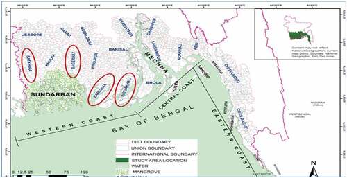
These zones are the southwestern coastal zone with mangrove forests, the central coast with numerous geomorphological active offshore islands and slightly elevated eastern zones (Quader et al., Citation2017). This paper addresses the western coastal zone, which falls under the Khulna division and also part of Patuakhali district. Several papers related to climate change and disasters addressed this area as the Southwestern coastal area (Islam et al., Citation2019; C. K. Saha, Citation2015; Nicholls et al., Citation2018).
Geographically, the area is bounded between21°30N and 23°15 northern latitude and 89°00 and 90°00 eastern longitudes. This region is part of the world’s largest continuous mangrove forest, the Sundarbans, as well as estuarine marshlands and numerous rivers, canals, and tributaries. The Southwestern coastal area is depicted as a non-deltaic/inactive delta area with a large network of river systems, tidal channels, and dynamic estuaries. Most of the Southwestern coastal areas are within only 1–3 m of the mean sea level (Shameem et al., Citation2014). This area accounts for around 10% of the national population and around 16% total land area of Bangladesh. This area has grabbed the attention of multidisciplinary researchers and development workers since it has distinct geophysical, environmental, and socio-economic characteristics. The detailed locations of the studied villages are furnished in .
Table 1. Depicting the study area.
In the Southwestern coastal areas, the poverty level is relatively higher compared with most other areas of Bangladesh (World Bank, Citation2016). Interactive Poverty Map prepared by World Bank (Citation2016) denotes the poverty level of studied districts varies from 19–46% (Barguna 19% and Satkhira 46%). However, income level of the villagers indicates that more than 80% of people in the studied villages are living below the poverty line. People are mostly dependent on agriculture-related works, fishing, day labor, and van and rickshaw pulling. Since Sundarbans, the largest mangrove forest around the globe, is located in this area, many households are dependent on the livelihood related to mangroves, especially, wood and honey collection. Mangroves of the area support feeding and breeding grounds for fish and shrimp species, enriching the area in fisheries biodiversity (Parvin et al., Citation2010), which is one of the main livelihood options of Southwestern coastal Bangladesh.
2.2. Study period and studied aspects
This study is a part of a five years (from 2014–2019) SATREPS (Science and Technology Research Partnership for Sustainable Development) project titled Research Project on Disaster Prevention/Mitigation Measures against Floods and Storm Surges in Bangladesh, which was supported by Japan Science and Technology Agency.
During the project period, different parts of southwestern coastal districts were visited to examine local communities` disaster experiences, problems and lessons learnt from previous disasters. Communities present problems and their strength, weakness, opportunities, and threats are also identified through a participatory approach. Present institutional network in the coastal villages is investigated and what is the expected stakeholders’ network is explored.
2.3. Data collection approach and analysis
Rather than quantitative data collection, this study relies on a qualitative approach based on local communities` perceptions and assessments. shows the main approaches of the study and their outcomes. To understand communities` past disaster experiences, problems, and learnings, we applied several Participatory Rapid Rural Appraisal (PRRA) tools, namely field observation (Transect Walk), Focus Group discussion (FGDs) and Key Informant interviews (KII) (see, ). The data associated with the PRRA tools were validated through FGDs and KII. In these exercises, communities present problems and prospects, inducing their weakness and limitations in coping capacities.
Figure 2. Data collection at different villages.
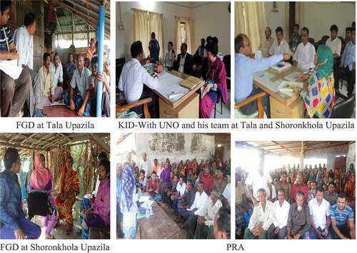
Table 2. Approaches of data collection and outcomes.
To define PRA, Robert Chambers stated that PRA is ‘a family of approaches and methods to enable rural people to share, enhance, and analyze their knowledge of life and conditions, to plan and to act.’ He defines PRA as an approach and method to learning about rural life and conditions from, with and by rural people (Chambers, Citation1994). Respecting this definition of PRA, this study aims to understand disaster experiences, problems, threats, opportunities, and institutional support from rural people. Therefore, in each of the studied villages, PRA was conducted to collect the information listed in .
3. Steps of data collection through PRA
3.1. Step 1- selection of the southwestern coastal districts and sub-districts
There are mainly six districts that are adjacent to Bay of Bengal in the southwestern coastal zone of Bangladesh. Among these six districts, four districts () are selected considering their vulnerabilities to coastal disasters (mainly cyclone, tidal surges, and coastal floods). Discussion with coastal belt and disasters experts and literature review facilitate the selection of these four districts and five sub-districts (will be mentioned as Upazila later on) from the districts.
3.2. Step 2: seeking cooperation from government and local government official
As an initial approach of the study Upazila Executive Official who is called as UNO (Upazila Nirbahi Officer) was contacted. Here it should be mentioned that UNO is the chief Government Official at the sub-district level of Bangladesh. With the explanation of the goal and approaches of the research UNO’s cooperation was requested. UNO of each sub-district helped to select the most vulnerable unions and villages of the Upazila. UNO gave official order to each respective Union Parishad Chairman (UPC) and Ward Commissioner (WC) (local government elected persons) to cooperate this study. Before PRA a separate meeting was conducted with local government’s elected members to explain whole approach and aspects of PRA. Union Parishad Chairman and Ward Commissioner helped to select the most vulnerable villages, which is termed as communities hereafter. PRA schedule was fixed for each village. UPC and WC were requested to invite villagers from all ethnic group, economic and professional strata.
3.3. Step 3- approach of PRA
On the respective day of PRA in each village, about 50–100 villagers were gathered at a school building or in the office of local government. At least two of the authors of this paper directly involved to conduct PRA in each village. Furthermore, in each PRA native speaker researcher was involved in order to avoid misunderstanding. One or two research assistants facilitate the researchers. Communities’ previous disaster experiences, problems, causes and effects, lesson learnt from disasters and their present problems were plotted one after another by active participation of different villagers including male and female, Hindu, and Muslim (ethnicity), literate or illiterate and villagers from different livelihoods.
At the concluding state of PRA, villagers were requested to rank their present problems and to draw their present networks of different stakeholders (with whom they are connected for different purposes). Villagers were not so satisfied to the present stakeholders’ pattern. Therefore, they themselves proposed for a modification of the pattern.
3.4. Step 4- validation of PRA by focus group discussions (FGD) and key-informants discussions
After having the PRA results from different villages, in each an FGD was conducted where about 25–40 people were gathered. This focused group was composed of people from different livelihood. They were requested to list about at least five strengths, weakness, opportunities, and threats of the village (community). Outcomes of SWOT were checked back with the problems, lessons, and their stakeholders. Apart from FGD, KID was conducted where UNO, UPC, WC, School teachers and NGO officials joined.
3.5. Step 5- combining PRA results of nine villages or communities
All researchers involved in conducting PRA were gathered together in few different sessions. From disaster experiences to stakeholders’ network, all diagrams sketched by the villagers during PRA in each village were analyzed, information were sorted and summarized by the researchers. Qualitative information from PRA were summarized and prepared the final diagrams and tables for this paper. For instance, drinking water crisis is mentioned in different way in different communities by using different words and finally combining their different words researchers agreed to mention it as ‘drinking water crisis’.
3.6. Study’s ethical protocols
The ethical protocols of social sciences research and field-based study were fully followed in this study. In every village before starting PRA all participants were informed in detail about the study and their permission was given before their active involvement and data collection. If they were willing to participate in the research, they were asked to sign the consent document. Regarding the use of their comments and photos, as well as photos of different villages and people, copyright consent was also obtained. At no stage of this study were respondents’ personal identities and personal information disclosed anywhere without their consent.
3.7. Scope and limitations
This study has limited its scope to disasters and associated issues and problems. The scope of this study is also limited to qualitative analysis using PRA approach of information presentation.
Nature and extent of disasters, problems, lessons learned, potentials and institutional networks are slightly different among studied villages. However, after collecting all information and having PRA outcomes authors accumulated all information and tried to develop tables and figures with aggregated information. During the discussion it is tried to mention the village name where any problem or issues are remarkable.
4. Results
4.1. Disasters in southwestern coastal area: experiences, problems and lesson learnt by the community
4.1.1. Disaster experiences
People in the coastal area of Bangladesh live with different hazards and disasters. But the types of hazards are to some extent different in different coastal zones of Bangladesh. Because of the presence of mangrove forest, the southwestern zone is relatively stable in terms of soil erosion and flood, while the other coastal parts are quite vulnerable to sea flooding. Apart from the cyclone and flooding, waterlogging, arsenic contamination, and salinity intrusion in soil and water are considered silent and slow-onset disasters in some parts of southwestern coastal areas. The following section highlights southwestern coastal community`s disaster experiences, associated problems and lesson learnt by previous disasters. During this project period, a field investigation was done in different coastal villages. PRA was organized in every studied village focusing on different aspects. Villagers were requested to make a disaster history calendar based on their experiences. shows the disaster history of the studied villages.
Table 3. Disaster experiences in southwestern coastal villages since 1980s to 2021.
In each of the studied village cyclone and associated tidal surges are common disasters. Heavy rainfall and flooding do not happen every year but every after 4/5 years heavy rainfall and flooding turn severe. Water logging is not a problem for each of the studied villages. Villages of Islamkathi union are facing waterlogging for almost whole years for more than two decades. However, after any severe cyclone collapse and breaching of the embankment are a common problem of different coastal villages.
4.2. Problems in previous disasters-causes and effects
The villagers made a long list of different problems. Many of those problems were interlinked and same in nature. From the long list, all problems were grouped into five main problems (). After finalizing the list of the problems, they faced in previous different disasters, villagers were requested to identify the causes and effects of each of the problems. From their perception, villagers identified the causes and effects of each problem. presents the problems and causes and after-effects of those problems that is prepared by the villagers (about 110 villagers gave their views to prepare this list).
Table 4. Problems faced in previous disasters and lesson learnt.
4.3. Lesson learnt from previous disasters
Multidimensional problems during previous disasters and consequent effects disrupted all aspects of the lives of the coastal community, at least for several weeks after any disaster. All these problems and their sufferings gave them the opportunities to learn valuable lessons. All the lessons that coastal villagers gained from their suffering during previous disasters are listed by using Participatory Rural Appraisal. The following section highlights these lessons. denotes the practices and awareness after lessons learned from their lives after experiencing different disasters.
Figure 3. Practices and awareness after lessons learned from previous disasters.
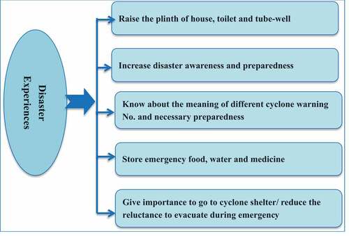
This study combined the list of about 200 villagers and finally listed the five broad practices and awareness that they have incorporated in their lives (). According to the villagers, after having disaster experiences, especially cyclone Sidr and Aila, people give importance to evacuation after having disaster warning. Now they have clearly understood the meaning of different numbers of cyclone warning. Villagers know what are the necessary preparedness and actions they need to take with different warning numbers (e.g., what they need to do when warning no. is 4 or 5 and so on). They prepare for emergency food, water and medicine during disaster season, especially having cyclone warning. Further, in many cases, even the poor have tried to raise the plinth of their houses and toilets. Many of the villagers claimed that they know the meaning of a cyclone warning and they know what they need to do according to the warning number. It is noticed that these villagers are relatively more aware and prepared after having experienced and learning lessons from different disasters.
During PRA approach villagers ranked the five main problems of their villages (). They also sketched the problem tree of their villages, listed the cause and effects of those problems, and showed the interlinks among those. Researchers facilitate their drawing of a problem tree. is the edited version of the problem tree sketched by the villagers. Analysing and it is vividly understood that infrastructure-related problems are the key causes of all problems and sufferings of coastal villagers that they faced in past years and are facing at present.
Figure 4. Problem tree of southwestern coastal villages.
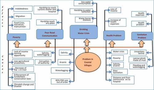
Table 5. Problems ranking in southwestern coastal area of Bangladesh.
The problem tree that is sketched by the villagers denotes five key problems of the villages and the causes and effects of those problems (). All these problems are interlinked and their causes and effects are also associated and have backwards and forward linkages. For instance, water crisis is linked with a health problem and health problem has an effect on income and thus to enhance poverty. Similarly sanitation problem is linked with health and water crisis. Poor road communication is linked with povery, water crisis and health problems of the villagers.
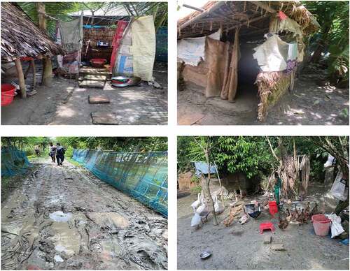
Analysing causes of previous problems during disasters (), problem ranking () and problem tree () here a list of causes of problems is provided that have close association with poor infrstructural facilities of coastal villages. These causes are rapture of earthen embankment, temporary poorly constructed houses, overflow of river, did not receive any early warning, road communication was disrupted and no way to go for income/search for food, corruption of authority during road construction and maintenance work, most of the roads are low lying and earthen, submerge of tube-wells, poor Sanitation, plinth of Toilets was made of mud and low in height, no drainage system, water logging, and distance and poor communication to go to hospital. A glimpse of coastal villages’ infrastructure related problems is shown in .
Figure 5. Glimpses of coastal villages’ problems (poor road condition, unhealthy sanitation, and poor infrastructure facilities).
5. Discussions
Bangladesh is one of the most disaster-prone countries in the world, due to its geographical settings and location. Coastal communities of Bangladesh are the most vulnerable to different hazards and disasters. Every year coastal communities are facing cyclone, storm surges, floods, and such other coastal hazards at different scales. However, tropical cyclones with high winds and storm surges hit Bangladesh every three years on average (Parvin et al., Citation2018; Saha & James, Citation2017). Other studies also claim that (Mondal, et al., 2013; Alam & Andrew, Citation2010), cyclone, storm surge-induced flooding, riverine coastal flooding, water logging, salinity intrusion and coastal erosion are the main climate and hydrologic hazards in southwestern coastal area of Bangladesh. Despite having substantial natural resources, geophysical and socio-economic conditions have made this area one of the most disaster vulnerable areas in Bangladesh and even in the world. Various hazards and disasters are causing additional problems and imposing relentless struggle and hardship in the lives of Southwestern coastal community. However, frequent hazards and disaster experiences of this coastal community have contributed to their lesson learning and developing long-term adaptation techniques (Alam & Andrew, Citation2010).
The results from the present study highlighted that the news media and different studies increasingly report embankment failures and breaches. In coastal areas, most of the embankments are constructed with earthen materials that are vulnerable to heavy rain and storm surges during cyclones. Due to embankment collapse water from adjacent rivers enter the crop fields and villages, causing flooding and waterlogging. Collapse of embankment also enhances salinity intrusion in studied villages. For more than the last three decades, southwestern coastal villagers are struggling with salinity problems (Szabo et al., Citation2016; Zaman et al., Citation2016). High salinity is causing crop failure too. However, crop failure is not reported as a common problem in coastal villages. Mainly, after cyclone Sidr in 2007 and cyclone Aila in 2009 most of the studied villages faced crop failure due to the intrusion of saline water in the crop fields.
Disaster affects every aspect of life and livelihood (B. Hossain et al., Citation2020; Mallick et al., Citation2017). Based on the present study, the villagers faced multidimensional problems and losses and damages that disturbed almost every sector of their lives. Damages and loss of houses, crops and livestock, loss of income, food and water crisis, sanitation and communication disruption were the main reported problems during previous disasters. As a cause, embankment failure, siltation of surrounding rivers, poor drainage system, overflow of the river, salinity intrusion and lack of awareness are identified by the villagers. Due to these problems majority of the villagers had to face measurable conditions and they had to take temporary shelters on schools and roads, faced starvation, indebtedness, and loss of assets immediately after the disaster. Many of them had faced health crises and hardships to arrange drinking water for a long time after the disaster, especially after cyclones Sidr and Aila. Embankment breaches and salinity intrusion in coastal villages are most common in coastal Bangladesh; especially after every cyclone that leads to disaster. Embankment breaches were pointed as one of the main cause of the previous disaster problems in the studied villages. Similarly, other studies reported on the instances of embankment failures and breaches in the past several decades. Since most of the embankments are constructed with earthen materials, their faulty design and wrong construction made them prone to breach (Khan et al., Citation2015; Zaman et al., Citation2016). The rapid increase in groundwater salinity, river salinity and soil salinity due to sea level rise, over-extraction of groundwater, upstream diversion of surface water and shrimp farming are pointed as the principal reasons of salinity in coastal villages of Bangladesh. This salinity problem is leading to food and water crisis and eventually, poverty and health-related problems are faced by the coastal community due to this salinity. Further, due to the food and water crisis, and lack of income people had to face starvation and had no drink polluted or arsenic-contaminated water. Poor sanitation conditions, water pollution and malnutrition led to health problems. Nevertheless, having medicine and health facilities was critical, as road communication was disrupted.
Researchers argue that to prevent accidents, it is essential to learn a lesson from past accidents and incidents (Dash et al., Citation2016). It is also claimed that people learn lessons from their experiences and the education provided to them and these lessons contribute to adapting to future disasters (Mishra & Sura, Citation2007). Since different components of disaster experience have different effects on self-protective behavior (Mishra & Sura, Citation2007), southwestern coastal villagers also improved and changed their practices and behavior in different aspects of their lives. A recent study conducted by Parvin et al. (Citation2022) claimed that after cyclone Aila, among the students and teachers of southwestern coastal areas disaster-related knowledge, training, participation, and sharing have been significantly improved. The results from our study were also in agreement with Rahman and Rahman (2015), who reported that the people in the coastal areas have incorporated traditional practices for making their homes and homesteads resilient to disasters based on the previous disaster experiences and lessons. They applied traditional knowledge for agriculture, floodplain management and climatic-season-based cropping, and fish-farming and developed major transportation by boat. With the application of traditional knowledge and experiences, people of coastal areas are trying to adapt with disasters and disaster induced problems. However, in their daily lives, they are struggling with numerous problems that are somehow getting aggravated by frequent disasters and often hindering their disaster preparedness, response, recovery and overall adaptation process. Parvin et al. (Citation2008) argued that coastal areas of Bangladesh are highly vulnerable to natural and man-made hazards and disasters like coastal flooding, cyclones, storm surges, erosion, salinity, arsenic contamination, and pollution, etc. Even in these days, all problems are continuing, and in this study, villagers also pointed the similar problems due to the disasters. a have grouped all problems into five main problems and the associated problems are listed as causes and effects of those five key problems (). ThefFollowing section highlights all the problems that southwestern coastal villagers are combating in their everyday lives.
Critical observation of all causes associated with each problem indicate a direct or indirect association with poor infrastructures. However, scholars claimed that infrastuctures are significanly affect the recovery process of a community (Koliou et al., Citation2020). Out of the five topmost problems of coastal areas except for poverty all other four problems are directly related to the critical infrastructures of a community. Furthermore, poverty is also associated with infrastructural problems. Rahman and Rahman (Citation2015b) claimed that cyclonic storms associated with tidal floods seriously affect the infrastructures and thus the livelihoods. In recent decade drinking water crisis in coastal Bangladesh is reported by different studies (M.A. Abedin et al., Citation2014; Parvin et al., Citation2010). They also highlighted the climate change-induced water crisis in coastal Bangladesh. Nevertheless, water crisis still remains as the topmost problems in southwestern coastal communities. This water crisis is leading to health problem and poor sanitation that are listed as 5th and 4th prime problems. According to the Safe Drinking Water Foundation 80% of all illnesses in developing countries are caused by unsafe drinking water and the spread of waterborne diseases. Nonavailability of drinking water is one of the most crucial and urgent problems in this area. Compared to past years, the people in Satkhira District experienced the highest level of suffering from drinking water shortages after the 2009 Cyclone Aila (M. Abedin et al., Citation2019).
6. Concluding remarks
These research findings have demonstrated how disasters have impacted the financial well-being, livelihood and living pattern of coastal populations. Every after four five years these southwestern coastal communities combat with severe disasters, especially cyclone and storm surges. Despite of their lessons and experiences from previous disasters, they are continuing to struggle disaster associated livelihood and infrastructural problems. Drinking water crisis, poor roads and communication facilities, poverty, health and sanitation problems are continuing and are ranked as key the problems of the studied coastal villages. Infrastructural issues are marked as the center of of all problems. In order to minimize impacts of different problems and to alleviate the causes associated with the problems, poor coastal villagers seek help and supports from different stakeholders. However, villagers pointed different limitations and urges for the reform of the stakeholders’ networks. Haque and Uddin (Citation2013) also claim that the main problem with different institutions is that they are not aware of their pre- and post-disaster duties and responsibilities. Further, researchers argued that Union Porishad have crisis of enough man power, and Cyclone Preparedness Program (CPP) and Red Crescent Society (RCS) volunteers are not responsible enough to implement their rules at local level (Paul et al., Citation2022). Therefore, in this study too villagers have proposed the improved stakeholders’ networks pattern (). It is thought that collaboration among these stakeholders may strengthen the capacity of the organizations to implement disaster risk reduction (DRR) activities at local level and thus to minimize their problems (Haque & Uddin, Citation2013; Paul et al., Citation2022). In order to understand the risks and problems associated with disasters, all stakeholders including decision makers, practitioners and community members need to assess the disaster resilience of their communities (Tariq et al., Citation2021). Different disasters associated problems where poor infrastructural conditions are diminishing the resilience of coastal communities. Therefore, through establishing better stakeholders’ and institutional networks coastal communities’ continuing problems can be minimized and thus their resilience can be enhanced. The improved infrastructure resilience could be further strengthened by active collaboration among the identified stakeholders, and this approach should follow the proposed network.
Figure 6. Stakeholders networking and infrastructures for disaster resilienct coastal community.
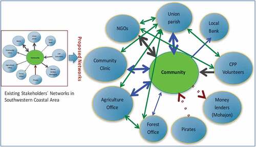
Apart from this, Bangladesh government should take the necessary physical precautions to safeguard against such catastrophic tragedies. The policy makers and stakeholders should design capacity-building programs helping households adjust to the effects of climate change and various modes of subsistence to lessen the vulnerability of coastal communities. Along with the proposed pattern, villagers demand for additing of some new stakeholders to the network. Local Government and Engineering Department (LGED) is the key of the additional proposed stakeholder. Coastal villagers perceived that Government organization LGED which is the key of rural infrastructure development should work with the villagers. Along with Local Government, relevant government organizations, NGOs, formal and informal institutions and local communities need to work together to build resilient rural infrastructure such as embangments, quality health services roads and water suppy and sanitation facilities to enhace their resilience and to make the coastal communities strong enough to combat continuing disasters and build back better.
Authors contribution
Conceptualization and research design: Gulsan Ara Parvin, Hajime Nakagawa and Rajib Shaw.
Research and data collection: Masashi Sakamoto, Gulsan Ara Parvin, Kumiko Fujita.
Data analysis: Gulsan Ara Parvin, Kumiko Fujita, Rajorshi Dasgupta.
Writing original draft: Gulsan Ara Parvin and Md. Anwarul Abedin.
Writing—reviewing and editing: Md. Anwarul Abedin, Mohammad Golam Kibria, Bingunath Ingirige, Rajorshi Dasgupta, Hajime Nakagawa, Rajib Shaw, Kumiko Fujita.
All authors have read and agreed to the published version of the manuscript.
Acknowledgments
The authors acknowledge the support received for conducting this research from the Science and Technology Research Partnership for Sustainable Development (SATREPS: 0510000000023) Project titled “Research on Disaster Prevention/Mitigation Measures against Floods and Storm Surges in Bangladesh”. Japan Science and Technology Agency is highly appreciated to provide financial and technological supports to the research. The authors also acknowledge the support from CDRI for providing the APC of this article.
Disclosure statement
The Coalition for Disaster Resilient Infrastructure (CDRI) reviewed the anonymised abstract of the article, but had no role in the peer review process nor the final editorial decision.
Correction Statement
This article has been corrected with minor changes. These changes do not impact the academic content of the article.
Additional information
Funding
References
- Abedin, M., Collins, A. E., Habiba, U., & Shaw, R. (2019). Climate change, water scarcity, and health adaptation in southwestern coastal Bangladesh. International Journal of Disaster Risk Science, 10(1), 28–42. https://doi.org/10.1007/s13753-018-0211-8
- Abedin, M. A., Habiba, U., & Shaw, R. (2014). Community perception and adaptation to safe drinking water scarcity: Salinity, arsenic, and drought risks in coastal Bangladesh. International Journal of Disaster Risk Science, 5(2), 110–124. https://doi.org/10.1007/s13753-014-0021-6
- Ahmed, B., Sammonds, P., Saville, N. M., Le, M., Suri, V., Bhat, K., M, G., Thusu, B., Hussain, G., Wangmo, K., & Thusu, B. (2019). Indigenous mountain people’s risk perception to environmental hazards in border conflict areas. International Journal of Disaster Risk Reduction, 35, 101063. https://doi.org/10.1016/j.ijdrr.2019.01.002
- Alam, M., (2003). Bangladesh country case study. National Adaptation Program of Action (NAPA) Workshop, National Environment Commission, 9-11, September 2003.doi:, Bhutan.
- Alam, E., & Andrew, E. C. (2010). Cyclone disaster vulnerability and response experiences in coastal Bangladesh. Disasters, 34(4), 931–954. doi:10.1111/j.1467-7717.2010.01176.x.
- Barbier, E. B., & Hochard, J. P. (2018). The impacts of climate change on the poor in disadvantaged regions. Review of Environmental Economics and Policy, 12(1), 26–47. https://doi.org/10.1093/reep/rex023
- Bostick, T. P., Holzer, T. H., & Sarkani, S. (2017). Enabling stakeholder involvement in coastal disaster resilience planning. Risk Analysis, 37(6), 1181–1200. https://doi.org/10.1111/risa.12737
- Chambers, R. (1994). The origins and practice of participatory rural appraisal. World Development, 22(7), 953–969. https://doi.org/10.1016/0305-750X(94)90141-4
- Dash, A. K., Bhattacharjee, R. M., & Paul, P. S. (2016). Lessons learnt from Indian inundation disasters: An analysis of case studies. International Journal of Disaster Risk Reduction, 20, 93–102. https://doi.org/10.1016/j.ijdrr.2016.10.013
- Haque, C. E., & Uddin, M. S. (2013). Disaster management discourse in Bangladesh: A shift from post-event response to the preparedness and mitigation approach through institutional partnerships. In John Tiefenbacher, Approaches to disaster management-examining the implications of hazards, emergencies and disasters. IntechOpen, 33–54. doi:10.5772/54973.
- Hoque, S. F., Hope, R., Arif, S. T., Akhter, T., Naz, M., & Salehin, M. (2019). A social-ecological analysis of drinking water risks in coastal Bangladesh. Science of the Total Environment, 679, 23–34. https://doi.org/10.1016/j.scitotenv.2019.04.359
- Hossain, B., Sohel, M. S., & Ryakitimbo, C. M. (2020). Climate change induced extreme flood disaster in Bangladesh: Implications on people’s livelihoods in the Char Village and their coping mechanisms. Progress in Disaster Science, 6, 100079. doi:10.1016/j.pdisas.2020.100079.
- IPCC. (2013). Working group i report “climate change 2013: The physical science basis”. Intergovernmental Panel on Climate Change Fifth Assessment Report.
- Islam, M. S., Afrin, S., Ahsan, M. N., Haider, M. Z., Mamun, T. M., & Das, D. K. (2019). Households’ willingness to pay for disaster resilient safe drinking water sources in southwestern coastal Bangladesh. International Journal of Disaster Risk Science, 10(4), 544–556. https://doi.org/10.1007/s13753-019-00229-x
- Karim, M. F., & Mimura, N. (2008). Impacts of climate change and sea-level rise on cyclonic storm surge floods in Bangladesh. Global Environmental Change, 18(3), 490–500. https://doi.org/10.1016/j.gloenvcha.2008.05.002
- Khan, M. M. H., Bryceson, I., Kolivras, K. N., Faruque, F., Rahman, M. M., & Haque, U. (2015). Natural disasters and land-use/land-cover change in the southwest coastal areas of Bangladesh. Regional Environmental Change, 15(2), 241–250. https://doi.org/10.1007/s10113-014-0642-8
- Knutson, T., John, R., McBride, L., Johnny, C., Kerry, E., Greg, H., Chris, L., Isaac, H., James, P., Kossin, A. K., & Srivastava, M. S. (2010). Tropical cyclones and climate change. Nature Geoscience, 3(3), 157–163. doi:10.1038/ngeo779.
- Koliou, M., John, W., Van, D. L., Therese, P., McAllister, B., Ellingwood, R., Maria, D., & Harvey, C. (2020). State of the research in community resilience: Progress and challenges. Sustainable and Resilient Infrastructure, 5(3), 131–151. https://doi.org/10.1080/23789689.2017.1418547
- Mallick, B., Ahmed, B., & Vogt, J. (2017). Living with the risks of cyclone disasters in the south-western coastal region of Bangladesh. Environments, 4(1), 13. https://doi.org/10.3390/environments4010013
- Mallick, B., Rahman, K. R., & Vogt, J. (2011). Coastal livelihood and physical infrastructure in Bangladesh after cyclone Aila. Mitigation and Adaptation Strategies for Global Change, 16(6), 629–648. https://doi.org/10.1007/s11027-011-9285-y
- Mercer, J., Kelman, I., Lloyd, K., & Suchet‐Pearson, S. (2008). Reflections on use of participatory research for disaster risk reduction. Area, 40(2), 172–183. https://doi.org/10.1111/j.1475-4762.2008.00797.x
- Mishra, S., & Sura, D. (2007). Do lessons people learn determine disaster cognition and preparedness? Psychology and Developing Societies, 19(2), 143–159. doi:10.1177/097133360701900201.
- Nicholls, R. J., Hutton, C. W., Lázár, A. N., Adger, W. N., Allan, A., Whitehead, P. G., & Payo, A. (2018). An integrated approach providing scientific and policy-relevant insights for South-West Bangladesh. In R. J. Nicholls, C. W. Hutton, W. N. Adger, S. E. Hanson, M. M. Rahman, & M. Salehin (Springer) Eds. Ecosystem services for well-being in deltas: Integrated assessment for policy analysis. 49–69. https://doi.org/10.1007/978-3-319-71093-8
- Nordhaus, W. (2019). Climate change: The ultimate challenge for economics. American Economic Review, 109(6), 1991–2014. https://doi.org/10.1257/aer.109.6.1991
- Pain, R., & Francis, P. (2003). Reflections on participatory research Area. 35, 46–54.
- Parvin, G. A., Ahsan, S. R., & Shaw, R. (2010). Community-based coastal zone management in Bangladesh. Community and Coastal Zone Management, 165–184.
- Parvin, G. A., Rahman, R., Fujita, K., & Shaw, R. (2018). Overview of flood management actions and policy planning in Bangladesh. International Journal of Public Policy, 14(5–6), 423–443. https://doi.org/10.1504/IJPP.2018.096700
- Parvin, G. A., Takahashi, F., & Shaw, R. (2008). Coastal hazards and community-coping methods in Bangladesh. Journal of Coastal Conservation, 12(4), 181–193. https://doi.org/10.1007/s11852-009-0044-0
- Parvin, G. A., Takashino, N., Islam, S., Rahman, H., Abedin, A., & Ahsan, R. (2022). Disaster-induced damage to primary schools and subsequent knowledge gain: Case study of the cyclone aila-affected community in Bangladesh. International Journal of Disaster Risk Reduction, 102838. https://doi.org/10.1016/j.ijdrr.2022.102838
- Paul, S. K., Naim, J., & Mou, M. A. (2022). Assessing efficiency of disaster management institutions at local level in the coastal Region of Bangladesh. Nature-Based Solutions, 2, 100024. https://doi.org/10.1016/j.nbsj.2022.100024
- Quader, A. M., Khan, A. U., & Matthieu, K. (2017). Assessing risks from cyclones for human lives and livelihoods in the coastal region of Bangladesh. International Journal of Environmental Research and Public Health, 14(8), 831. https://doi.org/10.3390/ijerph14080831
- Rahman, M. M., & Ahmad, S. (2018). Health, livelihood and well-being in the coastal delta of Bangladesh. Ecosystem Services for Well-Being in Deltas, 131–145. https://doi.org/10.1007/978-3-319-71093-8
- Rahman, M. M., Haque, S. M., Galib, S. M., Islam, M. A., Parvez, M., Hoque, M., … Brown, C. (2020). Mud crab fishery in climate vulnerable coastal Bangladesh: An analysis towards sustainable development. Aquaculture International, 28(3), 1243–1268. https://doi.org/10.1007/s10499-020-00523-2
- Rahman, M. A., & Rahman, S. (2015a). Natural and traditional defense mechanisms to reduce climate risks in coastal zones of Bangladesh. Weather and Climate Extremes, 7, 84–95. https://doi.org/10.1016/j.wace.2014.12.004
- Rahman, S., & Rahman, M. A. (2015b). Climate extremes and challenges to infrastructure development in coastal cities in Bangladesh. Weather and Climate Extremes, 7, 96–108. https://doi.org/10.1016/j.wace.2014.07.004
- Saha, M. K. 2014. Changing profile of cyclones in the context of climate change and adaptation strategies in Bangladesh. Journal of Bangladesh Institute of Planners , 2075, 9363.
- Saha, C. K. (2015). Dynamics of disaster-induced risk in southwestern coastal Bangladesh: An analysis on tropical cyclone aila 2009. Natural Hazards, 75(1), 727–754. https://doi.org/10.1007/s11069-014-1343-9
- Saha, S. K., & James, H. (2017). Reasons for non-compliance with cyclone evacuation orders in Bangladesh. International Journal of Disaster Risk Reduction, 21, 196–204. https://doi.org/10.1016/j.ijdrr.2016.12.009
- Sarker, M., Islam, N., Peng, Y., Khatun, M., Alam, G. M., Shouse, R. C., & Amin, M. (2022). Climate finance governance in hazard prone riverine islands in Bangladesh: Pathway for promoting climate resilience. Natural Hazards, 110(2), 1115–1132. https://doi.org/10.1007/s11069-021-04983-4
- Shameem, M. I. M., Salim, M., & Ray, R. (2014). Vulnerability of rural livelihoods to multiple stressors: A case study from the southwest coastal region of Bangladesh. Ocean & Coastal Management, 102, 79–87. doi:10.1016/j.ocecoaman.2014.09.002.
- Szabo, S., Sarwar, M. H., Adger, N. W., Zoe, M., Sayem, A., Attila, N. L., & Sate, A. (2016). Soil salinity, household wealth and food insecurity in tropical deltas: Evidence from south-west coast of Bangladesh. Sustainability Science, 11(3), 411–421. https://doi.org/10.1007/s11625-015-0337-1
- Tariq, H., Pathirage, C., & Fernando, T. (2021). Measuring community disaster resilience at local levels: An adaptable resilience framework. International Journal of Disaster Risk Reduction, 62, 102358. https://doi.org/10.1016/j.ijdrr.2021.102358
- World Bank. (2016), bangladesh interactive poverty maphttps://www.worldbank.org/en/data/interactive/2016/11/10/bangladesh-poverty-maps
- Zaman, M. W., Asik, T. Z., Rumi, M. Y., & Shahin, H. M. (2016). Geotechnical hazard analysis of river embankment of Bangladesh and its protectability. GEOMATE Journal, 10(22), 2050–2057. doi:10.21660/2016.22.5329.