
 ?Mathematical formulae have been encoded as MathML and are displayed in this HTML version using MathJax in order to improve their display. Uncheck the box to turn MathJax off. This feature requires Javascript. Click on a formula to zoom.
ABSTRACT
This paper examines communities’ accessibility to critical facilities such as hospitals, emergency medical services, and emergency shelters when facing flooding. We use travel speed reduction to account for flood-induced partial road failure. A modified betweenness centrality metric is also introduced to calculate the criticality of roads for connecting communities to critical facilities. The proposed model and metric are applied to the Delaware road network under 100-year floods. This model highlights the severe critical facility access loss risk due to flood isolation of facilities. The mapped post-flooding accessibility suggests a significant travel time increase to critical facilities and reveals disparities among communities, especially for vulnerable groups such as long-term care facility residents. We also identified critical roads that are vital for post-flooding access to critical facilities. The results of this research can help inform targeted infrastructure investment decisions and hazard mitigation strategies that contribute to equitable community resilience enhancement.
1. Introduction
Critical facilities, such as emergency medical service (EMS) stations, hospitals, and emergency shelters, must remain functional and accessible to protect life-saving and life-sustaining activities during and after a disaster (FEMA, Citation2022). Access to these critical facilities is key to the health and well-being of the communities, preventing morbidity and mortality associated with disasters (Esmalian et al., Citation2021a; Twumasi-Boakye & Sobanjo, Citation2021). The road network plays a pivotal role in connecting people to these critical services (Boakye et al., Citation2022; Logan & Guikema, Citation2020). However, road networks often provide unequal levels of accessibility for different communities (Gangwal & Dong, Citation2022). Additionally, critical facilities’ accessibility is constantly challenged by hazard disruptions (Bonilla-Félix & Suárez-Rivera, Citation2019; Esparza et al., Citation2021; Kaiser et al., Citation2021; K. Liu et al., Citation2022a). Disruptions either cut off access to critical facilities or increase travel time. This exacerbates disparities among communities.
Flooding is the most common and costly source of disruption (CRED, Citation2018; NCEI, Citation2019), and its frequency and intensity are expected to grow due to climate change, posing a particularly great threat to coastal communities and beyond (Hauer et al., Citation2016, Citation2021; Sweet et al., Citation2022), as the compound failure from sea-level rise, storm surge, and extensive rainfall escalates. While increased flooding is expected to disrupt road networks, the exact nature and distribution of these disruptions remains unclear. Thus, there is a strong need to map disrupted critical facilities’ accessibility so that equitable infrastructure investments and hazard mitigation strategies can be derived to safeguard coastal communities (Barrette et al., Citation2022; Meerow et al., Citation2019; Nagenborg, Citation2019; Young et al., Citation2021).
The network-based method is one of the most suitable and frequently used approaches to systematically evaluate critical facility accessibility (W. Wang et al., Citation2019). Dong et al. (Citation2019) proposed a robust component to evaluate if communities can access hospitals after earthquake disruption. Weiss et al. (Citation2020) studied travel time to healthcare facilities globally and examined access to healthcare under no disruption. Gangwal and Dong (Citation2022) examined access to critical facilities such as hospitals during flooding without considering travel time. Novak and Sullivan (Citation2014) examined the accessibility to emergency services using the proposed critical closeness accessibility metric without considering multiple critical facilities scenarios and partial failure effects, such as reduced travel speed due to flooding.
Despite the invaluable insights learned from the existing efforts, each study only partially addresses the relationship between flooding and partial measures of accessibility, such as increased travel time. This research therefore proposes an integrated network approach that accounts for flood-induced partial failure, multiple critical facilities of different types, and reduced travel time in critical facility accessibility. The scope of this research entails three paradigms. First, we will extend a partial failure integrated road network disruption model by integrating the depth disruption function in travel time calculation. Second, communities’ accessibility to different critical facilities is mapped and disparities are revealed. Third, a modified betweenness centrality metric is developed to identify the critical roads for connecting communities to critical facilities and for recovering critical facility accessibility by identifying flooded roads that would restore isolated communities’ access. We demonstrate the application of the proposed model through a case study of Delaware under the current condition of 100-year floods.
The rest of the paper is organized as follows. Section 2 summarizes prior research in the field of flood-induced network disruption of road networks and critical road identification. Section 3 presents the depth-disruption function used to calculate travel time, the method to calculate road criticality, and the study site of Delaware. Section 4 presents the results of derived redundancy across the network and identified critical roads for both post-flood critical facility access and accessibility restoration. Section 5 presents the discussion and talks about the limitations of the study along with future directions. Finally, section 6 concludes the paper with major findings and their significance.
2. Literature review
2.1. Flood-disrupted road network analysis
Flooding becomes increasingly common as the climate and built environment change (Mobley et al., Citation2021; Nofal & Van De Lindt, Citation2022). The impact of flooding on transportation, in particular, is devastating as it impedes people’s access to critical services and affects communities’ well-being (Dong et al., Citation2020a; Esparza et al., Citation2021; Gangwal & Dong, Citation2022; Ramirez-Rios et al., Citation2022; Yuan et al., Citation2022). A growing body of literature focuses on modeling and assessing the performance of flood-disrupted road networks (Bucar & Hayeri, Citation2020; He et al., Citation2021; Morelli & Cunha, Citation2021; Papilloud & Keiler, Citation2021; Wiśniewski et al., Citation2020). For example, Singh et al. (Citation2018) integrated weather-related information and land use patterns into a hydrodynamic model along with the safety speed function to predict road vulnerability. The proposed framework was used to assess the spatial vulnerability for two rainfall events with a 10-year and 100-year return period. Li and Willems (Citation2020) proposed a hybrid model that integrates a suite of lumped hydrological models and logistic regression for fast and probabilistic urban pluvial flood prediction. Using the inundation map produced by hydraulic and hydrologic (H&H) models.
Among the various methods used to assess the flood-disrupted transportation systems, network-theory-based models have been widely adopted to study the affected road network (Dong et al., Citation2022, Citation2020b; Duan & Lu, Citation2014; Zhang & Alipour, Citation2019). For example, Alabbad et al. (Citation2021) examined the accessibility to critical amenities under 100 and 500-year flood scenarios using graph theoretical methods. Kermanshah and Derrible (Citation2017) developed a stochastic model to assess the road network robustness in facing flash floods using betweenness centrality and service accessibility. However, the network theory-based analysis often adopts a binary link failure criterion (i.e., either functional or dysfunctional) that does not fully capture the effect of flooding on road functionality, while several studies have shown a nonlinear relationship between disruption and road performance. For example, Liu et al. (Citation2022b) adopted the Bureau of Public Roads (BPR) function to consider the impact of disruption on travel time. Lam et al. (Citation2020) modeled the temporal functional capacity losses of infrastructure and examined the spatio-temporal risk of a road network in Switzerland. To relate flood-depth to travel speed decrease on roads, Pregnolato et al. (Citation2017) developed and calibrated a depth-disruption function that delineates the relationship between the depth of standing water and vehicle speed. Researchers have then extensively used the depth-disruption function to assess partial failure due to flood-water impact on transportation systems. For example, Abdulla et al. (Citation2020) used a network diffusion-based method to capture the impact of floods on a road network and further used the flood depth and vehicle speed to categorize the network into susceptible and impacted. Fereshtehpour et al. (Citation2018) examined the travel time increase and the emergency services coverage area change using the depth-disruption function. Despite the existing effort on flood impact on transportation, there are very limited studies that capture the impact of flooding on different communities’ access to critical facilities considering road partial failure and network isolation. In this research, we bridge this gap by integrating the road partial failure models with network-based methods to assess the impact of flooding on transportation network resilience, with a focus on communities’ access to critical facilities.
2.2. Critical roads identification
All roads are important as they connect people and places, but they do not share equal criticality because of their unique locations in the network. Road criticality has been widely studied to help prioritize infrastructure development. Jafino et al. (Citation2020) summarized seventeen road criticality metrics derived from (i) transport studies and (ii) network theory. The metrics derived from transport studies include weighted and unweighted travel cost (Gauthier et al., Citation2018; Wang et al., Citation2013), user exposure analysis (impact of disruptions experienced by users; Jenelius & Mattsson, Citation2015), weighted and unweighted accessibility (Luathep et al., Citation2011), congestion (Zhou et al., Citation2015), and exposure to disaster (Koks et al., Citation2019; Sohn, Citation2006). On the other hand, the metrics derived from network theory include network-centrality (Geertman et al., Citation2019; Henning et al., Citation2017; Snelder et al., Citation2012), network efficiency (Dehghani et al., Citation2014), and connectivity (Mishra et al., Citation2012; Snelder et al., Citation2012).
These criticality metrics have been further modified to adapt to different study contexts and data types. For example, Li et al. (Citation2020) proposed a traffic flow betweenness index to identify critical roads using origin-destination travel demand. Feng et al. (Citation2019) used GPS trajectory data and combined the physical network with dynamic traffic flow to model a directed weighted road network. The model introduced a new correlation coefficient to evaluate the system performance and identify critical roads. Chen et al. (Citation2012) proposed an impact area vulnerability analysis approach to identify critical roads and assess the impact of road closures while taking into account the varying demand. Gangwal and Dong (Citation2022) identified critical roads corresponding to early warning points for Harris County, Texas, road network under Hurricane Harvey and 500-year floods. Aydin et al. (Citation2019) used the origin-destination betweenness centrality to identify critical intersections for accessing health care services. Helderop and Grubesic (Citation2019) introduced a modified grid-based centrality method to assess the criticality of road segments considering the potential traversability of off-network and whole-landscape features during an extreme event. Mostafizi et al. (Citation2017) proposed criticality of links depending on the impact a link failure might have on an evacuation on foot, which indirectly impacts both safety and mortality rates.
Identification of critical roads during daily travel or after disruption can help traffic managers anticipate congestion and derive efficient control and routing strategies. But, the roads that connect communities with essential services such as hospitals, emergency medical services, and shelters are more critical because the loss of access to these critical facilities will negatively affect communities’ well-being (Dong et al., Citation2020a). More importantly, the adverse health impact from critical facility access loss will be further exacerbated in a disaster setting, particularly for socially vulnerable communities (Esmalian et al., Citation2021a,Citationb). Identification of the critical roads for accessing critical facilities can also facilitate infrastructure investment decision-making (Dong et al., Citation2021). However, there are few studies on service-oriented critical road identification. To address this research and practice need, this research utilizes a network-based approach to systematically measure road criticality by considering both flood-induced road failure and communities’ access to the critical facility.
Roads that enable re-connection between communities and critical facilities are also important. Existing studies mainly use an optimization approach to identify the critical roads for resilience recovery. For example, Liu et al. (Citation2022b) identified the optimal repair strategy using a modified network robustness metric based on travel and repair cost minimization. Merschman et al. (Citation2020) prioritized the repair of four bridges in Mobile, Alabama after disruption considering the travel time and distance, network connectivity, and access to the emergency facility. Aksu and Ozdamar (Citation2014) identified the critical roads for restoration that maximize network accessibility during disaster response and recovery. Akbari et al. (Citation2021) used an online optimization model to derive the road restoration strategy that minimizes the time for a network to regain connectivity. Ulusan and Ergun (Citation2018) developed a mixed-integer programming model and proposed a Cent-Restore heuristic to prioritize the road restoration effort for a disrupted road network. However, existing optimization approaches are more suitable for smaller network exercises and very limited in large-scale network applications. Additionally, the optimization solution only applies to a specific disruption scenario and provides limited insight for long-term general hazard mitigation and resilience planning. In this study, we address this research gap by proposing a weighted road criticality metric that takes into account the restoration of communities’ post-flooding access to critical facilities.
3. Methodology
3.1. Modeling flood-induced road network failure
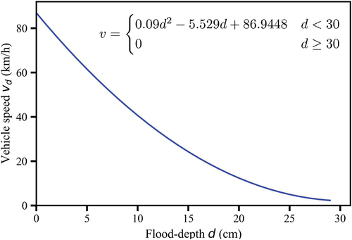
We model flood-induced partial road failure by adopting the depth-disruption function (Pregnolato et al., Citation2017) as follows:
where is the flood depth in centimeters. This nonlinear relationship calculates the vehicle’s travel speed limit
of road providing different flood depths. Here, we consider a maximum of 30 cm as the flood depth limit for safe travel (Pyatkova et al., Citation2019; Yin et al., Citation2016). Next, the estimated travel speed limit
is compared with the free flow speed (
) of the road and the smaller one is adopted for link travel time calculation. The travel time is derived using the length of the road as shown in EquationEq. 1
(1)
(1) .
where is the length of the road and
. The depth-disruption function in and EquationEq. 1
(1)
(1) is used to estimate the travel time of every link in the road network. The travel time after flooding is used to map accessibility to the closest hospital, emergency shelter, and EMS. The NetworkX library in Python is used to calculate the travel time to the closest critical facility. We also identify the closest node for all properties and approximate their travel time to be same as that of the node.
Figure 1. Depth-disruption function.
3.2. Betweenness centrality of post-flooding critical facility access
Roads that are frequently used by communities for accessing critical facilities post flooding are deemed important. Conventional network theory-based methods involve studying the mobility and accessibility of disrupted networks using the size of the giant component or the largest connected cluster as the metric (Dong et al., Citation2022). However, the access to critical facilities is not considered. We adopt the metric of robust component (Dong et al., Citation2019) to examine each node’s access to critical facilities. The concept of the robust component is illustrated in ). Before flooding, critical facilities A, B, & C can serve all communities. After flooding, critical facility C is flooded and thus loses serviceability. Facility B is isolated by flooding, so no one can access service here, leaving critical facility A to provide service to the rest of the network.
Figure 2. Heuristic illustration of robust component and edge criticality for system connectivity.
Once the accessible critical facility is identified, we use a modified weighted betweenness centrality to identify critical roads for post-flooding critical facility travel, with critical facilities being the destination and regular nodes as the origin. First, the shortest path between each node and its corresponding closest critical facility is identified. Next, the number of occurrences that a link appeared on the node-facility shortest path is recorded (see, EquationEq. 2)
(2)
(2) .
where is the set of origin-destination pairs with node as origin and the respective closest critical facility as destination and road
is the number of paths passing through edge
. The obtained values are then normalized and the critical roads for accessing critical facilities are identified (see, EquationEq. 3)
(3)
(3) .
3.3. Road criticality for post-flooding access restoration
Roads whose recovery can restore communities’ access to critical facilities are also important. One approach is to derive the optimal sequences that result in maximum resilience recovery (Kaviani et al., Citation2017; Sohouenou & Neves, Citation2021). However, these approaches mainly focus on small networks and provide limited insights into each road’s contribution to a community’s recovery. In this paper, we propose a weighted road criticality that encapsulates its importance to different communities and contribution to critical facility access recovery.
The heuristic illustration of the post-flooding access restoration criticality measurement is demonstrated in ). First, we will identify the shortest paths (in terms of travel time) that connect each disconnected cluster of nodes to its nearest critical facility, but only focus on the inundated roads that require restoration. ) shows the two disconnected cluster of nodes, of size 20 nodes and
of 8 nodes, with path
and path
on their shortest path to their nearest critical facility, respectively. If a disconnected cluster of nodes has multiple shortest paths, the path that has more overlaps with other clusters paths (primary criteria) or shorter lengths (secondary criteria) is selected. Second, we examine the amount of access that restoration of each link can recover. In this case, roads ‘
‘ and ‘
‘ are only responsible for 20 nodes’ access recovery. While roads ‘
‘ and ‘
‘ contribute to the recovery of critical facility access for both cluster of nodes
and
, and thus achieves a weight of 28 (20 + 8). The mathematical formulation of the above process can be represented as in EquationEq. 4
(4)
(4) :
where is the number of disconnected cluster of nodes,
is the size of cluster
, and
is the set of flooded links in the shortest path for cluster
to reach critical facility. The obtained values are then normalized and the road criticality for community-critical facility connectivity is identified (see, EquationEq. 5)
(5)
(5) .
3.4. Study site
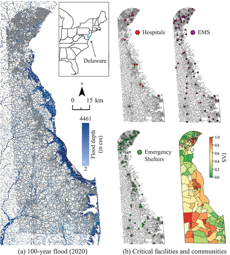
Delaware has the lowest average elevation of any US state and is highly vulnerable to storm-related flooding, which is expected to become more frequent and intense with climate change. There are 22,000 people at risk of coastal flooding in Delaware, and this number is expected to increase to 31,000 by 2050 (Climate Central, Citation2015). Delaware also faces threats from sea-level rise, with a 1.5-meter increase in sea level projected by the year 2100 (Delaware Sea Grant, Citation2022). Increased frequency of sunny day flooding during high tides provides evidence of these growing threats (Howell, Citation2020).
Road network
The state-wide road network acquired from the Delaware Department of Transportation contains 100,887 nodes (i.e., intersections) and 117,491 links (i.e., roads), with 14,512 of them being one way streets. The road network is first mapped in GIS and then modeled as a directed network in Python NetworkX library. Three types of critical facilities collected from HIFLD (Citation2022) are investigated, including 16 hospitals, 142 emergency shelters, 72 emergency medical service (EMS) facilities (as shown in ).
Figure 3. Study Site, Delaware, USA. (a) 100-year flood maps overlaid with the road network of Delaware. (b) The spatial distribution of three critical facilities (CF) and communities demarcated based on the social vulnerability index (SVI). The critical facilities include hospitals (16), emergency medical service stations (72), and emergency shelters (142).
Property data
We use the First Street Foundation’s property data and map 422,668 properties in the Delaware road network. The data includes the latitude, longitude, and flood factor of various properties, including residential units.
Flood risk data
The flood risk raster layer is acquired through partnership with the First Street Foundation. They developed a nationwide probabilistic flood model that considers flooding risk due to rainfall (global pluvial), riverine flooding (global fluvial), and coastal surge flooding (Bates et al., Citation2021). The model was upgraded using USGS National Elevation data for topography, and Global Runoff Data for rainfall-runoff. The flood risk projections for both current and future scenarios was estimated using a factor to modify the historic return periods. The First Street flood layer matches fairly closely with the FEMA 1% annual probability flood maps, but we use the First Street layer because it incorporates multiple types of flood risk. We adopted the 100-year flood risk (1% annual flood chance) data for the year of 2020 in this paper. The probability of a 100-year flood occurring during any 30-year period, a common length for mortgages, is 26% (Delaware Sea Grant, Citation2022; USGS, Citation2022), so the likelihood that a resident experiences a 100-year type flood and related road closures is fairly high.
Social Vulnerability Index (SVI)
We adopt the social vulnerability index (SVI) created by the Centers for Disease Control and Prevention (CDC) in the study. The SVI considers four categories of community characteristics, including socioeconomic status, household composition disability, minority status language, and housing type transportation. The index is computed by synthesizing the aforementioned variables through the principal component analysis procedure (Cutter et al., Citation2012). The SVI is in the unit of census tract and can help us identify the communities that need support and attention before, during, and after a disaster (Flanagan et al., Citation2011). Because SVI is available at a census tract level, we use census tracts to approximate ‘community’ characteristics. We recognize that census tracts are an imperfect proxy for a community, as census tracts range in size from 1,200 to 8,000 people and may not follow jurisdictional or neighborhood boundaries. However, it is an initial starting point to match demographic traits to road access, and we anticipate this will be an area for improvement in future research.
4. Results
4.1. Assessing post-flooding critical facility accessibility
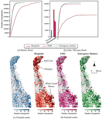
Accessibility to critical facilities is shown in , both during un-flooded conditions and as the increase in travel time after a 100-year flood (2020). The navy blue nodes in the flood map are inundated and thus have no access to critical facilities. Red nodes are isolated, as shown in , and also have no access to critical facilities. The rest of the nodes are colored based on the travel time to the closest critical facility ()) and the increase in travel time ()). Delaware communities are subject to severe isolation risk from flooding, as red nodes dominate the map. In particular, southern Delaware is exposed to inland flooding (gray nodes), which is the major cause for community isolation.
Figure 4. Access to closest CFs (hospitals, EMS, and emergency shelters). (a) Travel time (in minutes) to the closest CF before flood. (b) The increase in travel time after a 100-year flood (2020) is shown here. The flooded nodes and disconnected nodes to CFs are colored in navy blue and red.
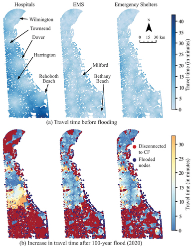
) shows the travel time to critical facilities before flooding. The variation is higher in the case of hospitals than EMS and emergency shelters. This is because there are fewer hospitals compared to the other two types of critical facilities. ) shows the travel time increase after 100-year flood. We calculate the average travel time to the closest critical facility before and after flooding. We notice a significant increase in travel time to critical facilities, including around 118% increase for hospitals, and 66% for both EMS and emergency shelters. We observe a particularly large increase in travel time to hospitals in Dover, Harrington, and Townsend regions. An increase in travel time to EMS and emergency shelters is also observed in the Dover and Townsend regions.
Apart from the spatial map of accessibility, we plotted the cumulative distribution of critical facility accessibility in to show the macroscopic accessibility profile. The curve in delineates the number of properties (y-axis) that have access to a critical facility within certain travel time ranges (x-axis). For example, 269,540 properties have access to a hospital within 10 minutes in a before-flooding scenario. This number drastically declines after flooding, as more properties experience longer travel times. The bar plot on the left side shows the number of flooded properties (gray region) and disconnected properties (red region). We observe that around 12% (12,270) of nodes are flooded and directly impact around 12% (50,969) properties. The flooded nodes cut off approximately 48% of nodes’ access to hospitals (2.96 times more than the inundated nodes). In terms of the number of properties, approximately 49% (206,603) of properties are isolated or lose access to hospitals (3.1 times more than flooded properties). The large number of disconnected properties demonstrates how the failure of a small number of roads can lead to severe critical facility accessibility loss during a disaster event. In order to visualize the location of the flooded and isolated properties after a 100-year flood, we spatially map the flooded and isolated nodes where the node color represents the number of properties it serves (see, (c) and (d)). In the case of hospitals, we observe a dense distribution of isolated nodes with high property numbers at Glasgow, Red Lion, and White Creek Manor. In case of EMS and Emergency shelters, there are few isolated nodes with high property numbers at Glasgow and Red Lion due to dense distribution of the critical facilities in these regions.
Figure 5. Distribution of critical facility access redundancy. (a)-(b) The number of properties is aggregated at each intersection in the road network. Travel time values are aggregated to generate a cumulative distribution function between the number of properties (y-axis) and the travel time in minutes (x-axis) (a) before flood and (b) after 100-year flood. The spatial distribution of (c) flooded nodes and (d) isolated nodes is generated where the color of the node represents the number of properties it serves.
Elderly residents and those with pre-existing medical conditions are among the populations expected to be most affected by disrupted access to critical facilities during flooding. Here, we particularly examine long-term care facilities’ (LTCF) access to the critical facilities through spatial mapping, using hospitals as an example in (results of EMS and emergency shelters are included in Supplementary Figure 1). The nodes represent the LTCFs and the color corresponds to the travel time to the closest hospital. Results show 36 LTCFs (out of 87) will likely lose access to hospitals after a 100-year flood, including 4 that were directly inundated (purple) and 32 that were isolated by the flood (red). The estimated maximum travel time for a LTCF resident to reach a hospital after a 100-year flood is 45.32 minutes, compared to 36.7 minutes before flooding. Moreover, there is an average of a 2.23 minutes (around 70%) increase for all the LTCFs to reach a hospital after a 100-year flood.
Figure 6. Long-term care facilities’ (LTCF) and minority population access to closest hospitals. (a) Travel time (in minutes) to closest hospital is mapped for LTCF after 100-year flood. (b) Integrated 3D plot of no access to hospitals with minority population map is presented. The bar height denotes the total number of properties in a census tract that has no access to hospitals.
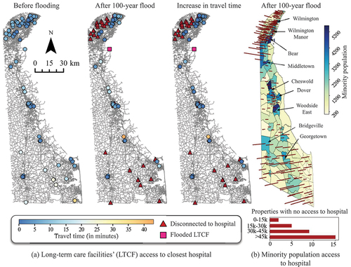
We also map Black, Indigenous, and communities of color (BIPOC, i.e., non-white non-Hispanic according to CDC SVI definition) with no access to CFs in ) results of EMS and Emergency shelters are included in Supplementary Figure 2). The total number of properties with no access to hospitals in each census tract is overlaid on the population map. We observe that many properties near Middletown and Bridgeville lose access. Regions such as Wilmington, Bear, Cheswold, Dover, and Woodside East have substantial BIPOC populations but have fewer properties affected. The integrated 3D plot of properties with no access to CFs with elderly population is presented in Supplementary Figure 3.
4.2. Identifying critical roads for accessing critical facilities
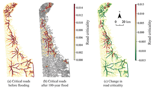
When accessing the closest critical facilities, some road segments are used more frequently as compared to others. These roads are key to post-flooding critical facility access and thus, of great interest for targeted infrastructure protection. We spatially map the frequency of each road that occurred in communities’ shortest paths to critical facilities. (a-b) shows the identified critical roads for accessing hospitals, both before and after the flooding. The criticality change is observed in ). In doing so, we can identify the roads that emerged as the new critical roads (red) after flooding. The critical roads for accessing EMS and Emergency shelters is presented in Supplementary Figure 4.
Figure 7. Critical roads for access to hospitals. The road criticality is spatially mapped and represented for three cases: (i) before flood; (ii) after 100-year flood; and (iii) change in critical roads. The grey roads in (b) represent the flooded and disconnected links in the system.
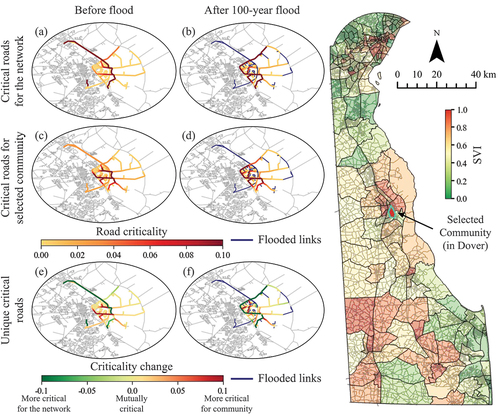
To identify critical roads for each community, only roads used by the nodes within that census tract to access critical facilities are considered. We can observe from that some roads are critical for pre-flooding network-wide hospital access, but not necessarily critical for a selected socially vulnerable community. When we derive the difference between network-wide criticality and community-specific criticality in 8(e) (f), we can determine if a road is more critical to the network or a specific community’s access to a hospital, or important in both scenarios. For example, out of 671 roads highlighted for the selected community in before flooding, 46 edges have road criticality greater than 0.1 (critical for the selected community) and 53 edges have road criticality less than −0.1 (critical for the network).
Figure 8. Critical roads comparison for access to hospitals in Dover, DE. The road criticality is calculated for access to hospitals before flood and after 100-year flood for a small community in Dover (social vulnerability index (SVI) 0.972). (a) & (b) represents the critical roads for the complete system; (c) & (d) represents critical roads for the community; (e) & (f) represent unique critical roads, i.e., the difference between the overall critical roads and critical roads for a particular community.
4.3. Prioritizing roads for critical facility accessibility restoration
Following the procedure proposed in and EquationEq. 5(5)
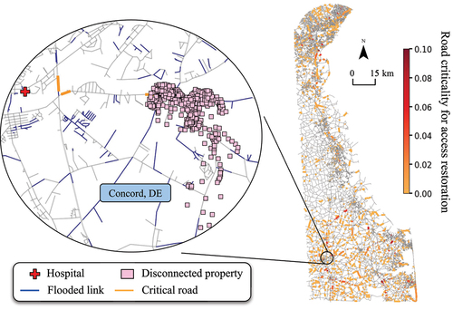
(5) , we identify the roads that are most critical to restore in order to restore critical facility accessibility in . A total of 4,703 roads (around 4% of the total roads in the network) are required to reconnect all the disconnected cluster of nodes to hospitals, increasing accessibility from 40,170 to 91,118 nodes (i.e., intersections), or 165,989 to 379,013 properties. More importantly, the restoration of only 308 roads (out of 4,703 roads) will re-establish hospital access for 33,665 nodes (around 27% of total nodes in the system), or 135,971 properties (around 32% of total properties in the system). This criticality mapping provides important analytical evidence for pre-flooding hazard mitigation and targeted road protection and post-flooding road restoration prioritization to ensure that communities have maximum access to critical services.
Figure 9. Critical roads connecting disconnected properties with hospitals. The road criticality after 100-year flood is calculated for the roads that provide disconnected nodes and corresponding properties access to hospitals. The illustrative example shows that restoration of 3 roads can connect 370 properties (118 nodes) to the hospital.
5. Discussions
This paper refines existing frameworks and proposes new methods to examine how floods affect the accessibility of critical facilities. Previous work has used network analysis to assess flood impact on road network. This work extends those methods in several ways: by using increased travel time as a measure of accessibility (Arrighi et al., Citation2019; Fereshtehpour et al., Citation2018; Pregnolato et al., Citation2017), rather than binary metrics of passable or impassable (Zhang & Alipour, Citation2019); by considering both inundation of roads (increasing travel time on roads) and isolation (communities who are unable to access critical facilities at all); by combining road networks with census tract-level demographics and social vulnerability metrics; by identifying roads whose restoration is most critical to restoring access, and considering this criticality both to the network as a whole and to specific communities. These methods open the potential for new lines of research, such as the equity implications of road restoration and road protection investments. These methods could also inform more nuanced emergency management plans for disaster risk reduction investments and recovery plans.
For example, the distinction between inundation and isolation has implications for emergency planning and for siting of new critical facilities. The network analysis results show that isolation is a bigger threat (Jasour et al., Citation2022; Logan et al., Citation2022) for Delaware coastal communities than direct inundation (). Isolation in Delaware shows an uneven distribution, with dense pockets of communities losing access to hospitals. This pattern is different for EMS and Emergency shelters because there are more of these facilities. Similarly, urban areas experience less isolation because there are more hospitals, EMS bases, and emergency shelters in these areas, so even if access to one facility is lost, residents are more likely to have access to other facilities. Wilmington and Rehoboth Beach, for example, benefit from numerous facilities.
Our results suggest that it is important for researchers and practitioners to carefully consider the consequences of isolation and inundation. The consequences of losing access to emergency services and a hospital, for example, may be different, depending on the reason why residents need access. Some populations require access to acute care services such as dialysis or opioid treatment (Kaiser et al., Citation2021; Thompson, Citation2017), while others may depend on reliable post-flooding access to pharmacies (Gangwal & Dong, Citation2022). For some of these facilities, a 3-minute delay in accessibility is not critical (e.g., a pharmacy), while for others it could be life-threatening (e.g., emergency response, ). This is one reason we examined access from long-term care facilities, where residents have a higher risk of experiencing a health emergency (Dong et al., Citation2020a), and why the increased travel time from long-term care facilities should be of concern if on-site emergency staff are not available. These types of nuances in terms of the difference between inundation and isolation and their relative importance for access to different types of critical facilities are an important area for future research to better understand how road closures affect residents’ health outcomes.
Just as not all facilities are equally critical, some roads are more critical than others to the network, and their criticality depends on the scale of the analysis. Our results in , for example, highlight that the roads that appear critical at a state level may not be the same roads that are critical at a census tract level. Methods to identify this disparity are an important step towards being able to identify the needs of different communities (e.g., Esmalian et al. (Citation2021a)) and to invest equitably in road protection and restoration (Mostafavi, Citation2018; NASEM, Citation2022). State-level transportation agencies might reasonably focus on state-level analyses of road criticality, but our results suggest that this could introduce unintended consequences and inequities. Initiatives at state and national levels to improve social justice (e.g., the Biden Administration’s Justice 40 initiative to invest 40% of federal funds in disadvantaged communities) will need methods to identify roads that are critical to disadvantaged communities. We used the Centers for Disease Control and Prevention Agency for Toxic Substances and Disease Registry’s social vulnerability index (SVI) as the criteria to identify vulnerable communities, and we used census tract data on race and ethnicity as a proxy for disadvantaged communities, but we recognize that these are far from ideal metrics. Vulnerability may be characterized in multiple ways, and there are limitations in using an index approach. Similarly, race and ethnicity do not always identify communities that have been discriminated against, underserved by government investment, or overburdened with environmental risks and hazards. Future work that draws on research exploring relationships between housing discrimination, migration, and other traits would provide greater nuance (Knighton et al., Citation2021; Maldonado et al., Citation2016; Martinich et al., Citation2013). The methods presented here require refinement, especially in how ‘disadvantaged communities’ are defined, but represent a first step.
Future work can also increase nuance in the range of flood risks considered. We used a 100-year flood map to identify the flooded roads. A flood map is a great tool for resilience planning in general, but it has some limitations in road disruption mapping. A flood map is an aggregation of multiple potential flood scenarios, and each flood scenario corresponds to a disruption pattern dependent on the different meteorological conditions at the time, such as precipitation intensity and location. Each disruption will then result in a unique accessibility profile. However, this study does not provide the accessibility result of each flood, but rather the aggregated accessibility results from all flood scenarios. To enhance the current accessibility mapping results, future work will integrate dynamic flood modeling (Barnard et al., Citation2019; Nofal & van de Lindt, Citation2021) to conduct a scenario-based accessibility analysis in future research. Future studies might also consider how risks will evolve with climate change, as a 100-year flood in 2020 may be a 20-year flood in 2050. By considering the probability of different road disruption scenarios in a range of flooding scenarios, we can derive probabilistic access loss risk maps that can better guide infrastructure investment prioritization. In addition, the 100-year flood map is based on the year 2020 while the road network is based on the Delaware Department of Transportation’s 2022 inventory. We acknowledge that the time gap between the two datasets may create a slight discrepancy in analysis. As road networks and flood risks are both continually changing, especially in response to new development in and near the floodplain and in response to climate change, matching flood maps and road inventories will continue to be a challenge. However, future work will need to consider the effect of inconsistencies in the timing of road data and flood projections.
Emergency managers, planners, and adaptation professionals frequently make decisions about how to prioritize resource allocation for risk reduction. In transportation terms, government officials at federal, state, and local levels have to identify which roads to prioritize for projects that prevent or reduce inundation or that re-open roads after they are flooded. The methods presented in this paper can assist officials in identifying roads that are most important for restoring access, with the caveats noted above. However, disaster recovery in a real-life situation is a dynamic process. For example, the sequence of road restoration can affect overall network accessibility (Wu & Wang, Citation2021), so the criticality of a road may change after the restoration of its counterparts. Thus, we will extend an optimization model in future work to derive the critical roads whose sequential restoration can rapidly recover the most critical facility accessibility. These types of innovations can inform practitioners both as they consider pre-flood risk reduction measures and as they engage in post-flood recovery.
6. Conclusion
This paper uses a network approach to examine Delaware coastal communities’ access to critical facilities such as hospitals, EMS, and emergency shelters in the face of a 100-year flood event. In particular, we consider the partial functional failure in flood-induced road disruption characterizations by adopting a non-linear relationship between travel speed and flood depth. Moreover, a modified betweenness centrality is developed to capture the road criticality when considering the communities’ access to critical facilities. We show that communities’ access to critical facilities is differentially affected by the flood, and flood-induced isolation poses greater threats to the accessibility of critical facilities as compared to direct flood impact. Specifically, 36 (out of total 87) long-term care facilities are disconnected from hospitals, with 32 of those being isolated. The flood results in an average increase in travel time to hospitals of 2.23 minutes, which could seriously affect individuals seeking urgent health care (eg. heart patients). We also identified the roads that are most important, particularly for socially vulnerable communities, for accessing critical facilities.
The methods presented herein will require continued refinement to better capture nuances in how different levels of access to different types of critical facilities affect different groups of residents. This will require additional research on scales of analysis, methods of measuring community characteristics, and consideration of additional types of critical facilities. Future work will also need to incorporate more dynamic methods for assessing flood risk and dynamic recovery efforts. These types of dynamic assessment will be particularly important in the light of climate change. Nevertheless, the methods presented herein represent important advances in understanding how floods affect the provision of health services.
CRediT statements
Utkarsh Gangwal: Conceptualization, Methodology, Analysis, Visualization, Writing- Original draft preparation. A.R. Siders: Conceptualization, Analysis, Reviewing & Editing, Funding acquisition. Jennifer Horney: Conceptualization, Analysis, Reviewing & Editing. Holly Michael: Conceptualization, Analysis, Reviewing & Editing. Shangjia Dong: Conceptualization, Methodology, Analysis, Visualization, Writing- Original draft preparation, Reviewing & Editing, Supervision, Funding acquisition.
Supplemental Material
Download PDF (5.5 MB)Acknowledgments
The authors would like to acknowledge funding support from the University of Delaware Research Foundation (UDRF) project #21A00986 and Delaware Department of Transportation project #T202266002, and the data support from the First Street Foundation and Stephen Pondo-Voigt (Whitman, Requardt & Associates). Any opinions, conclusions, and recommendations expressed in this research are those of the authors and do not necessarily reflect the view of the funding agencies. The authors would also like to thank the Editor and the anonymous reviewers for their constructive comments and valuable insights to improve the quality of the article.
Disclosure statement
The Coalition for Disaster Resilient Infrastructure (CDRI) reviewed the anonymised abstract of the article, but had no role in the peer review process nor the final editorial decision.
Supplementary material
Supplemental data for this article can be accessed online at https://doi.org/10.1080/23789689.2022.2149184
Additional information
Funding
References
- Abdulla, B., Kiaghadi, A., Rifai, H. S., & Birgisson, B. (2020). Characterization of vulnerability of road networks to fluvial flooding using sis network diffusion model. Journal of Infrastructure Preservation and Resilience, 1(1), 1–13. https://doi.org/10.1186/s43065-020-00004-z
- Akbari, V., Shiri, D., & Salman, F. S. (2021). An online optimization approach to post-disaster road restoration. Transportation Research Part B: Methodological, 150, 1–25. https://doi.org/10.1016/j.trb.2021.05.017
- Aksu, D. T., & Ozdamar, L. (2014). A mathematical model for post-disaster road restoration: Enabling accessibility and evacuation. Transportation Research Part E: Logistics and Transportation Review, 61, 56–67. https://doi.org/10.1016/j.tre.2013.10.009
- Alabbad, Y., Mount, J., Campbell, A. M., & Demir, I. (2021). Assessment of transportation system disruption and accessibility to critical amenities during flooding: Iowa case study. Science of the Total Environment, 793, 148476. https://doi.org/10.1016/j.scitotenv.2021.148476
- Arrighi, C., Pregnolato, M., Dawson, R., & Castelli, F. (2019). Preparedness against mobility disruption by floods. Science of the Total Environment, 654, 1010–1022. https://doi.org/10.1016/j.scitotenv.2018.11.191
- Aydin, N. Y., Casali, Y., Sebnem Duzgun, H., & Heinimann, H. R., (2019). Identifying changes in critical locations for transportation networks using centrality, in: International Conference on Computers in Urban Planning and Urban Management, Springer. pp. 405–423.
- Barnard, P. L., Erikson, L. H., Foxgrover, A. C., Hart, J. A. F., Limber, P., O’Neill, A. C., van Ormondt, M., Vitousek, S., Wood, N., Hayden, M. K., & Jones, J. M. (2019). Dynamic flood modeling essential to assess the coastal impacts of climate change. Scientific Reports, 9(1), 1–13. https://doi.org/10.1038/s41598-019-40742-z
- Barrette, P. D., Hori, Y., & Kim, A. M. (2022). The Canadian winter road infrastructure in a warming climate: Toward resiliency assessment and resource prioritization. Sustainable and Resilient Infrastructure, 1–19. https://doi.org/10.1080/23789689.2022.2094124.
- Bates, P. D., Quinn, N., Sampson, C., Smith, A., Wing, O., Sosa, J., Savage, J., Olcese, G., Neal, J., Schumann, G., Giustraini, L., Coxon, G., Porter, J., Amodeo, M., Chu, Z., Lewis-Gruss, S., Freeman, N., Houser, T., Delgado, M., … Krajewski, W. (2021). Combined modeling of us fluvial, pluvial, and coastal flood hazard under current and future climates. Water Resources Research, 57(2), e2020WR028673. https://doi.org/10.1029/2020WR028673
- Boakye, J., Guidotti, R., Gardoni, P., & Murphy, C. (2022). The role of transportation infrastructure on the impact of natural hazards on communities. Reliability Engineering & System Safety, 219, 108184. https://doi.org/10.1016/j.ress.2021.108184
- Bonilla-Félix, M., & Suárez-Rivera, M. (2019). Disaster management in a nephrology service: Lessons learned from hurricane maria. Blood Purification, 47(1–3), 199–204. https://doi.org/10.1159/000494580
- Bucar, R. C., & Hayeri, Y. M. (2020). Quantitative assessment of the impacts of disruptive precipitation on surface transportation. Reliability Engineering & System Safety, 203, 107105. https://doi.org/10.1016/j.ress.2020.107105
- Chen, B. Y., Lam, W. H., Sumalee, A., Li, Q., & Li, Z. C. (2012). Vulnerability analysis for large-scale and congested road networks with demand uncertainty. Transportation Research Part A: Policy and Practice, 46, 501–516. https://doi.org/10.1016/j.tra.2011.11.018.
- Climate Central. (2015). Delaware should do more to prepare for coastal flooding. Coastal Flooding, States at Risk: Delaware https://riskfinder.climatecentral.org/state/delaware.us?comparisonType=county&forecastType=NOAA2017_int_p50&level=5&unit=ft. Accessed 26 September, 2022.
- CRED. (2018). Natural disasters in 2017: Lower mortality, higher cost. centre for research on the epidemiology of disasters, Brussels, Belgium. Research Institute Health Society (IRSS), Universite catholique de Louvain URL. https://cred.be/sites/default/files/CredCrunch50.pdf
- Cutter, S. L., Boruff, B. J., & Shirley, W. L. (2012). Social vulnerability to environmental hazards. In Cutter, S.L., (editor), Hazards vulnerability and environmental justice (pp. 143–160). Routledge.
- Dehghani, M. S., Flintsch, G., & McNeil, S. (2014). Impact of road conditions and disruption uncertainties on network vulnerability. Journal of Infrastructure Systems, 20(3), 04014015. https://doi.org/10.1061/(ASCE)IS.1943-555X.0000205
- Delaware Sea Grant, (2022). Understanding flood risk: Help dealware communities prepare for storm flooding and sea level rise. https://www.deseagrant.org/flood-risk
- Dong, S., Esmalian, A., Farahmand, H., & Mostafavi, A. (2020a). An integrated physical-social analysis of disrupted access to critical facilities and community service-loss tolerance in urban flooding. Computers, Environment and Urban Systems, 80, 101443. https://doi.org/10.1016/j.compenvurbsys.2019.101443
- Dong, S., Gao, X., Mostafavi, A., & Gao, J. (2022). Modest flooding can trigger catastrophic road network collapse due to compound failure. Communications Earth & Environment, 3(1), 1–10. https://doi.org/10.1038/s43247-022-00366-0
- Dong, S., Malecha, M., Farahmand, H., Mostafavi, A., Berke, P. R., & Woodruff, S. C. (2021). Integrated infrastructure-plan analysis for resilience enhancement of post-hazards access to critical facilities. Cities, 117, 103318. https://doi.org/10.1016/j.cities.2021.103318
- Dong, S., Mostafizi, A., Wang, H., Gao, J., & Li, X. (2020b). Measuring the topological robustness of transportation networks to disaster-induced failures: A percolation approach. Journal of Infrastructure Systems, 26(2), 04020009. https://doi.org/10.1061/(ASCE)IS.1943-555X.0000533
- Dong, S., Wang, H., Mostafavi, A., & Gao, J. (2019). Robust component: A robustness measure that incorporates access to critical facilities under disruptions. Journal of the Royal Society Interface, 16(157), 20190149. https://doi.org/10.1098/rsif.2019.0149
- Duan, Y., & Lu, F. (2014). Robustness of city road networks at different granularities. Physica A: Statistical Mechanics and Its Applications, 411, 21–34. https://doi.org/10.1016/j.physa.2014.05.073
- Esmalian, A., Dong, S., Coleman, N., & Mostafavi, A. (2021a). Determinants of risk disparity due to infrastructure service losses in disasters: A household service gap model. Risk Analysis, 41(12), 2336–2355. https://doi.org/10.1111/risa.13738
- Esmalian, A., Dong, S., & Mostafavi, A. (2021b). Susceptibility curves for humans: Empirical survival models for determining household-level disturbances from hazards-induced infrastructure service disruptions. Sustainable Cities and Society, 66, 102694. https://doi.org/10.1016/j.scs.2020.102694
- Esparza, M., Esmalian, A., Dong, S., & Mostafavi, A. (2021). Examining spatial clusters for identifying risk hotspots of communities susceptible to flood-induced transportation disruptions. Computing in Civil Engineering, 482–489. https://doi.org/10.1061/9780784483893.060.
- FEMA., (2022). Federal emergency management agency: Prioritizing mitigation actions for critical facilities. Risk Mapping, Assessment and Planning (Risk MAP) URL: https://www.fema.gov/sites/default/files/documents/fema_prioritizing-mitigation-actions_critical-facilities_region-three-06-2021.pdf
- Feng, H., Bai, F., & Xu, Y. (2019). Identification of critical roads in urban transportation network based on gps trajectory data. Physica A: Statistical Mechanics and Its Applications, 535, 122337. https://doi.org/10.1016/j.physa.2019.122337
- Fereshtehpour, M., Burian, S. J., & Karamouz, M. (2018). Flood risk assessments of transportation networks utilizing depth-disruption function, in: World Environmental and Water Resources Congress 2018: Water, Wastewater, and Stormwater; Urban Watershed Management. Municipal Water Infrastructure; and Desalination and Water Reuse. American Society of Civil Engineers Reston, VA
- Flanagan, B. E., Gregory, E. W., Hallisey, E. J., Heitgerd, J. L., & Lewis, B. (2011). A social vulnerability index for disaster management. Journal of Homeland Security and Emergency Management, 8(1). https://doi.org/10.2202/1547-7355.1792
- Gangwal, U., & Dong, S. (2022). Critical facility accessibility rapid failure early-warning detection and redundancy mapping in urban flooding. Reliability Engineering & System Safety, 224, 108555. https://doi.org/10.1016/j.ress.2022.108555
- Gauthier, P., Furno, A., & El Faouzi, N. E. (2018). Road network resilience: How to identify critical links subject to day-to-day disruptions. Transportation Research Record, 2672(1), 54–65. https://doi.org/10.1177/0361198118792115
- Geertman, S., Zhan, Q., Allan, A., & Pettit, C. (2019). Computational Urban Planning and Management for Smart Cities. Springer.
- Hauer, M. E., Evans, J. M., & Mishra, D. R. (2016). Millions projected to be at risk from sea-level rise in the continental United States. Nature Climate Change, 6(7), 691–695. https://doi.org/10.1038/nclimate2961
- Hauer, M. E., Hardy, D., Kulp, S. A., Mueller, V., Wrathall, D. J., & Clark, P. U. (2021). Assessing population exposure to coastal flooding due to sea level rise. Nature Communications, 12(1), 1–9. https://doi.org/10.1038/s41467-021-27260-1
- Helderop, E., & Grubesic, T. H. (2019). Flood evacuation and rescue: The identification of critical road segments using whole-landscape features. Transportation Research Interdisciplinary Perspectives, 3, 100022. https://doi.org/10.1016/j.trip.2019.100022
- Henning, S., Biemelt, P., Abdelgawad, K., Gausemeier, S., Evers, H. H., & Trächtler, A. (2017). Methodology for determining critical locations in road networks based on graph theory. IFAC- PapersOnLine, 50(1), 7487–7492. https://doi.org/10.1016/j.ifacol.2017.08.1065
- He, Y., Thies, S., Avner, P., & Rentschler, J. (2021). Flood impacts on urban transit and accessibility—a case study of Kinshasa. Transportation Research Part D: Transport and Environment, 96, 102889. https://doi.org/10.1016/j.trd.2021.102889
- HIFLD., (2022). Homeland infrastructure foundation-level data. URL: https://hifld-geoplatform.opendata.arcgis.com/
- Howell, J., (2020). What does climate change look like in delaware?. Delaware Today. URL: https://delawaretoday.com/life-style/what-does-climate-change-look-like-in-delaware/.
- Jafino, B. A., Kwakkel, J., & Verbraeck, A. (2020). Transport network criticality metrics: A comparative analysis and a guideline for selection. Transport Reviews, 40(2), 241–264. https://doi.org/10.1080/01441647.2019.1703843
- Jasour, Z. Y., Reilly, A. C., Tonn, G. L., & Ferreira, C. M. (2022). Roadway flooding as a bellwether for household retreat in rural, coastal regions vulnerable to sea-level rise. Climate Risk Management, 36, 100425. https://doi.org/10.1016/j.crm.2022.100425
- Jenelius, E., & Mattsson, L. G. (2015). Road network vulnerability analysis: Conceptualization, implementation and application. Computers, Environment and Urban Systems, 49, 136–147. https://doi.org/10.1016/j.compenvurbsys.2014.02.003
- Kaiser, R., Karaye, I. M., Olokunlade, T., Hammond, T. A., Goldberg, D. W., & Horney, J. A. (2021). Hemodialysis clinics in flood zones: A case study of hurricane harvey. Prehospital and Disaster Medicine, 36(2), 135–140. https://doi.org/10.1017/S1049023X21000042
- Kaviani, A., Thompson, R. G., & Rajabifard, A. (2017). Improving regional road network resilience by optimised traffic guidance. Transportmetrica A: Transport Science, 13(9), 794–828. https://doi.org/10.1080/23249935.2017.1335807
- Kermanshah, A., & Derrible, S. (2017). Robustness of road systems to extreme flooding: Using elements of gis, travel demand, and network science. Natural Hazards, 86(1), 151–164. https://doi.org/10.1007/s11069-016-2678-1
- Knighton, J., Hondula, K., Sharkus, C., Guzman, C., & Elliott, R., (2021). Flood risk behaviors of United States riverine metropolitan areas are driven by local hydrology and shaped by race. Proceedings of the National Academy of Sciences 118, e2016839118.
- Koks, E. E., Rozenberg, J., Zorn, C., Tariverdi, M., Vousdoukas, M., Fraser, S., Hall, J., & Hallegatte, S. (2019). A global multi-hazard risk analysis of road and railway infrastructure assets. Nature Communications, 10(1), 1–11. https://doi.org/10.1038/s41467-019-10442-3
- Lam, J. C., Heitzler, M., Hackl, J., Adey, B. T., & Hurni, L. (2020). Modelling the functional capacity losses of networks exposed to hazards. Sustainable and Resilient Infrastructure, 5(1–2), 30–48. https://doi.org/10.1080/23789689.2018.1469357
- Li, F., Jia, H., Luo, Q., Li, Y., Yang, L., & Guo, Y. (2020). Identification of critical links in a large-scale road network considering the traffic flow betweenness index. PloS one, 15(4), e0227474. https://doi.org/10.1371/journal.pone.0227474
- Liu, Y., McNeil, S., Hackl, J., & Adey, B. T. (2022b). Prioritizing transportation network recovery using a resilience measure. Sustainable and Resilient Infrastructure, 7(1), 70–81. https://doi.org/10.1080/23789689.2019.1708180
- Liu, K., Zhai, C., Dong, Y., & Meng, X. (2022a). Post-earthquake functionality assessment of urban road network considering emergency response. Journal of Earthquake Engineering, 1–26. https://doi.org/10.1080/13632469.2022.2113001.
- Li, X., & Willems, P. (2020). A hybrid model for fast and probabilistic urban pluvial flood prediction. Water Resources Research, 56(6), e2019WR025128. https://doi.org/10.1029/2019WR025128
- Logan, T., Anderson, M., & Reilly, A., (2022). Isolation: Revising the estimated risk of sea-level rise. https://doi.org/10.21203/rs.3.rs-1523232/v1.
- Logan, T. M., & Guikema, S. D. (2020). Reframing resilience: Equitable access to essential services. Risk Analysis, 40(8), 1538–1553. https://doi.org/10.1111/risa.13492
- Luathep, P., Sumalee, A., Ho, H., & Kurauchi, F. (2011). Large-scale road network vulnerability analysis: A sensitivity analysis based approach. Transportation, 38(5), 799–817. https://doi.org/10.1007/s11116-011-9350-0
- Maldonado, A., Collins, T. W., & Grineski, S. E. (2016). Hispanic immigrants’ vulnerabilities to flood and hurricane hazards in two United States metropolitan areas. Geographical Review, 106(1), 109–135. https://doi.org/10.1111/j.1931-0846.2015.12103.x
- Martinich, J., Neumann, J., Ludwig, L., & Jantarasami, L. (2013). Risks of sea level rise to disadvantaged communities in the United States. Mitigation and Adaptation Strategies for Global Change, 18(2), 169–185. https://doi.org/10.1007/s11027-011-9356-0
- Meerow, S., Pajouhesh, P., & Miller, T. R. (2019). Social equity in urban resilience planning. Local Environment, 24(9), 793–808. https://doi.org/10.1080/13549839.2019.1645103
- Merschman, E., Doustmohammadi, M., Salman, A. M., & Anderson, M. (2020). Postdisaster decision framework for bridge repair prioritization to improve road network resilience. Transportation Research Record, 2674(3), 81–92. https://doi.org/10.1177/0361198120908870
- Mishra, S., Welch, T. F., & Jha, M. K. (2012). Performance indicators for public transit connectivity in multi-modal transportation networks. Transportation Research Part A: Policy and Practice, 46, 1066–1085. https://doi.org/10.1016/j.tra.2012.04.006.
- Mobley, W., Sebastian, A., Blessing, R., Highfield, W. E., Stearns, L., & Brody, S. D. (2021). Quantification of continuous flood hazard using random forest classification and flood insurance claims at large spatial scales: A pilot study in southeast Texas. Natural Hazards and Earth System Sciences, 21(2), 807–822. https://doi.org/10.5194/nhess-21-807-2021
- Morelli, A. B., & Cunha, A. L. (2021). Measuring urban road network vulnerability to extreme events: An application for urban floods. Transportation Research Part D: Transport and Environment, 93, 102770. https://doi.org/10.1016/j.trd.2021.102770
- Mostafavi, A. (2018). A system-of-systems framework for exploratory analysis of climate change impacts on civil infrastructure resilience. Sustainable and Resilient Infrastructure, 3(4), 175–192. https://doi.org/10.1080/23789689.2017.1416845
- Mostafizi, A., Wang, H., Cox, D., Cramer, L. A., & Dong, S. (2017). Agent-based tsunami evacuation modeling of unplanned network disruptions for evidence-driven resource allocation and retrofitting strategies. Natural Hazards, 88(3), 1347–1372. https://doi.org/10.1007/s11069-017-2927-y
- Nagenborg, M. (2019). Urban resilience and distributive justice. Sustainable and Resilient Infrastructure, 4(3), 103–111. https://doi.org/10.1080/23789689.2019.1607658
- NASEM. (2022). National Academies of Sciences, Engineering, and Medicine: Equitable and resilient infrastructure investment. https://doi.org/10.17226/26633.
- NCEI., (2019). NOAA national centers for environmental information (NCEI) U.S. billion-dollar weather and climate disasters URL: https://www.ncei.noaa.gov/access/billions/
- Nofal, O. M., & van de Lindt, J. W. (2021). High-resolution flood risk approach to quantify the impact of policy change on flood losses at community-level. International Journal of Disaster Risk Reduction, 62, 102429. https://doi.org/10.1016/j.ijdrr.2021.102429
- Nofal, O. M., & Van De Lindt, J. W. (2022). Understanding flood risk in the context of community resilience modeling for the built environment: Research needs and trends. Sustainable and Resilient Infrastructure, 7(3), 171–187. https://doi.org/10.1080/23789689.2020.1722546
- Novak, D. C., & Sullivan, J. L. (2014). A link-focused methodology for evaluating accessibility to emergency services. Decision Support Systems, 57, 309–319. https://doi.org/10.1016/j.dss.2013.09.015
- Papilloud, T., & Keiler, M. (2021). Vulnerability patterns of road network to extreme floods based on accessibility measures. Transportation Research Part D: Transport and Environment, 100, 103045. https://doi.org/10.1016/j.trd.2021.103045
- Pregnolato, M., Ford, A., Wilkinson, S. M., & Dawson, R. J. (2017). The impact of flooding on road transport: A depth-disruption function. Transportation Research Part D: Transport and Environment, 55, 67–81. https://doi.org/10.1016/j.trd.2017.06.020
- Pyatkova, K., Chen, A. S., Djordjević, S., Butler, D., Vojinović, Z., Abebe, Y. A., & Hammond, M. (2019). Flood impacts on road transportation using microscopic traffic modelling techniques. In Behrisch, M., Weber, M., (eds.), Simulating urban traffic scenarios (pp. 115–126). Springer.
- Ramirez-Rios, D., Wallace, W. A., Kinsler, J., Viota, N. M., & Mendez, P. (2022). Exploring post- disaster transportation barriers to healthcare of socially vulnerable Puerto Rican communities. Natural Hazards Center, University of Colorado Boulder.
- Singh, P., Sinha, V. S. P., Vijhani, A., & Pahuja, N. (2018). Vulnerability assessment of urban road network from urban flood. International Journal of Disaster Risk Reduction, 28, 237–250. https://doi.org/10.1016/j.ijdrr.2018.03.017
- Snelder, M., Van Zuylen, H., & Immers, L. (2012). A framework for robustness analysis of road networks for short term variations in supply. Transportation Research Part A: Policy and Practice, 46, 828–842. https://doi.org/10.1016/j.tra.2012.02.007.
- Sohn, J. (2006). Evaluating the significance of highway network links under the flood damage: An accessibility approach. Transportation Research Part A: Policy and Practice 40, 491–506. https://doi.org/10.1016/j.tra.2005.08.006.
- Sohouenou, P. Y., & Neves, L. A. (2021). Assessing the effects of link-repair sequences on road network resilience. International Journal of Critical Infrastructure Protection, 34, 100448. https://doi.org/10.1016/j.ijcip.2021.100448
- Sweet, W., Hamlington, B., Kopp, R., Weaver, C., Barnard, P., Bekaert, D., Brooks, W., Craghan, M., Dusek, G., Frederikse, T., Garner, G, Genz, A., Krasting, J., Larour, E., Marcy, D., Marra, J., Obeysekera, J., Osler, M., Pendleton, M., Roman, D., Schmied, L., Veatch, W., White, K., & Zuzak, C . (2022). Global and regional sea level rise scenarios for the United States: Updated mean projections and extreme water level probabilities along US coastlines. Technical Report. NOAA Technical Report. https://doi.org/10.1016/j.tra.2005.08.006.
- Thompson, C. A. (2017). Special patient populations needed special attention during hurricane. American Journal of health-system Pharmacy, 74(22), 1841–1843. https://doi.org/10.2146/news170077
- Twumasi-Boakye, R., & Sobanjo, J. O. (2021). A computational approach for evaluating post-disaster transportation network resilience. Sustainable and Resilient Infrastructure, 6(3–4), 235–251. https://doi.org/10.1080/23789689.2019.1605754
- Ulusan, A.& Ergun, O. . (2018). Restoration of services in disrupted infrastructure systems: A network science approach. PloS one, 13(2), e0192272. https://doi.org/10.1371/journal.pone.0192272
- USGS., (2022). U.S. Geological Survey: Floods and recurrent intervals. https://www.usgs.gov/special-topics/water-science-school/science/floods-and-recurrence-intervals accessed on 08 January 2022
- Wang, J., Ding, Z., Zou, L., & Zuo, J., (2013). Proceedings of the 17th International Symposium on Advancement of Construction Management and Real Estate. Springer Science & Business Media.
- Wang, W., Yang, S., Stanley, H. E., Gao, J., Zeller, S., Voigtsberger, J., Schlott, N., Henrichs, K., Sann, H., Trinter, F., Schmidt, L. P. H., Kalinin, A., Schöffler, M. S., Jahnke, T., Lein, M., & Dörner, R. (2019). Local floods induce large-scale abrupt failures of road networks. Nature Communications, 10(1), 1–11. https://doi.org/10.1038/s41467-018-07882-8
- Weiss, D., Nelson, A., Vargas-Ruiz, C., Gligorić, K., Bavadekar, S., Gabrilovich, E., Bertozzi-Villa, A., Rozier, J., Gibson, H., Shekel, T., Kamath, C., Lieber, A., Schulman, K., Shao, Y., Qarkaxhija, V., Nandi, A. K., Keddie, S. H., Rumisha, S., Amratia, P., … Gething, P. W. (2020). Global maps of travel time to healthcare facilities. Nature Medicine, 26(12), 1835–1838. https://doi.org/10.1038/s41591-020-1059-1
- Wiśniewski, S., Borowska-Stefańska, M., Kowalski, M., & Sapińska, P. (2020). Vulnerability of the accessibility to grocery shopping in the event of flooding. Transportation Research Part D: Transport and Environment, 87, 102510. https://doi.org/10.1016/j.trd.2020.102510
- Wu, J., & Wang, P. (2021). Post-disruption performance recovery to enhance resilience of interconnected network systems. Sustainable and Resilient Infrastructure, 6(1–2), 107–123. https://doi.org/10.1080/23789689.2019.1710073
- Yin, J., Yu, D., Yin, Z., Liu, M., & He, Q. (2016). Evaluating the impact and risk of pluvial flash flood on intra-urban road network: A case study in the city center of shanghai, China. Journal of Hydrology, 537, 138–145. https://doi.org/10.1016/j.jhydrol.2016.03.037
- Young, C. E., Cunniff, S. E., & McDow, W. C. (2021). Evaluating and tracking investments in natural infrastructure to reduce coastal flooding hazards. Sustainable and Resilient Infrastructure, 1–18. https://doi.org/10.1080/23789689.2021.1920662.
- Yuan, F., Fan, C., Farahmand, H., Coleman, N., Esmalian, A., Lee, C. C., Patrascu, F. I., Zhang, C., Dong, S., & Mostafavi, A. (2022). Smart flood resilience: Harnessing community-scale big data for predictive flood risk monitoring, rapid impact assessment, and situational awareness. Environmental Research: Infrastructure and Sustainability, 2, 025006. https://doi.org/10.1088/2634-4505/ac7251.
- Zhang, N., & Alipour, A. (2019). Integrated framework for risk and resilience assessment of the road network under inland flooding. Transportation Research Record, 2673(12), 182–190. https://doi.org/10.1177/0361198119855975
- Zhou, Y., Fang, Z., Thill, J. C., Li, Q., & Li, Y. (2015). Functionally critical locations in an urban transportation network: Identification and space–time analysis using taxi trajectories. Computers, Environment and Urban Systems, 52, 34–47. https://doi.org/10.1016/j.compenvurbsys.2015.03.001