
ABSTRACT
Given the risk posed by escalating climate conditions, there is a need to assess how localities integrate adaptive planning into hazard mitigation and how this is enabled or constrained by existing planning institutions. We explore this for flood planning in the Lower Rio Grande Valley of Texas, United States – a largely underresourced and highly socioeconomically vulnerable area. Using Natural Language Processing to analyze county and regional hazard plans as well as transcripts of regional flood planning meetings, we find that adaptive planning is largely absent in the study area. Like many localities in the U.S., the communities in the study area have approached flood planning in static terms that do not fully consider future uncertainties; failed to engage diverse participation in planning; and neglected to pursue co-benefits possible with flood mitigation and other sectors. Critically, this may be a product of traditional planning institutions as well as limited local capacities.
1. Introduction
Planning for natural hazard risk reduction in the context climate change involves decision making under conditions of interacting, multiple uncertainties. Some of these are ‘deep uncertainties’ connected to long time horizons, nonlinear changes in climates and ecosystems, and the inability to reliably quantify the rate and magnitude of climate change (Babovic & Mijic, Citation2019; Bosomworth & Gaillard, Citation2019). Other uncertainties are associated with the ambiguities and unpredictability of socioeconomic systems, including population growth, land use change, social conflict, and the whims of political will (Babovic & Mijic, Citation2019; Buurman & Babovic, Citation2014). In the face of these uncertainties, a new paradigm of decision making has emerged that emphasizes the development of adaptive plans and policies (Haasnoot, Kwakkel, Walker, et al., Citation2013; Walker, Haasnoot, & Kwakkel, Citation2013).
Traditional planning approaches typically generate a static optimal plan to reduce vulnerability to a single ‘most likely’ future or to respond to a wide range of plausible future scenarios (Haasnoot, Kwakkel, Walker, et al., Citation2013; Manocha & Babovic, Citation2018). Because the future is largely unknowable, static optimal plans are likely to fail and adaptations are made ad-hoc to adjust to emerging risk conditions (Haasnoot, Kwakkel, Walker, et al., Citation2013). Decisions made are reactive and may create path dependency by locking in assets over long timeframes that entail high transfer costs when alternative options are pursued (Bloemen, Reeder, Zevenbergen, et al., Citation2018; Lawrence, Bell, & Stroombergen, Citation2019). In contrast, adaptive planning is dynamically robust. It accepts the multiple plausible futures resulting from deep uncertainties; commits to short-term actions that best respond to what is known; keeps long-term actions open; and adjusts actions dynamically in response to emergent risk conditions (Babovic & Mijic, Citation2019; Bosomworth & Gaillard, Citation2019; Manocha & Babovic, Citation2018; Walker, Haasnoot, & Kwakkel, Citation2013). Adaptive planning accepts that more information cannot resolve deep uncertainties; rather, diverse knowledge from many stakeholders is needed to create a shared understanding as the future unfolds (Buurman & Babovic, Citation2014; Rosa, Citation2008).
Given the irreversibility, cost-intensity, and long lifespans of infrastructure, adaptive planning is preferrable over traditional static planning approaches for guiding infrastructure investments (Manocha & Babovic, Citation2018). Studies of the application of adaptive planning have found that this approach increases awareness to uncertainties, provides political support for keeping long-term options open, and motivates decision makers to adjust plans in ways that better accommodate future conditions (Bloemen, Reeder, Zevenbergen, et al., Citation2018). When decision makers accept uncertainty inherent to the future and seek dialogue and knowledge sharing among diverse stakeholders, plans generate greater equity in risk reduction and promote a shared understanding of risk (Eakin, Parajuli, Yogya, et al., Citation2021; Rosa, Citation2008). Enabled by diverse intersectoral participation, adaptive planning can create mutual benefits across systems for the pursuit of risk reduction in conjunction with the delivery of public services (e.g., water, transportation and energy) and promotion of public health (Boyd, Pathak, van Diemen, et al., Citation2022).
As these benefits underscore, the incorporation of the interdependent attributes of adaptive planning – acceptance of uncertainty, engagement of diverse stakeholders in planning processes and pursuit of co-benefits – into local hazard planning is an important area to study. While studies have focused on these attributes individually (Boyd, Pathak, van Diemen, et al., Citation2022; Laukkonen, Blanco, Lenhart, et al., Citation2009; Stults & Larsen, Citation2020; Wang, Citation2013; Woodruff & Regan, Citation2019), there is a need to evaluate them in tandem. There is also a need to consider how adaptive planning may be realized given existing institutions of the governance system that may constrain the decision processes and policy options available. Scholars have noted this tension, arguing:
There exists a re-adaptation challenge in the scholarship and practice of adaptive governance that results from opposing tendencies and the widening gap between decision-making for future shocks (adaptation as it is widely understood) and the very real constraints imposed by entrenched institutional arrangements and physical infrastructure that is designed and operated for a narrowly defined set of conditions.
Natural hazard planning, in particular, is highly institutionalized as there are requirements and conditions set by federal governments for subnational entities to meet. In the United States (U.S.), disaster assistance and funding for hazard mitigation is made available by the Federal Emergency Management Agency (FEMA) only to those states and, by extension, localities that have approved hazard mitigation plans (Congressional Research Service, Citation2022). Not only do planning requirements present institutional constraints to adaptation, case studies have shown that adaptation options are circumscribed by decision cycles and choices of the past, made under specific institutional arrangements and in social and political contexts with asymmetric power (S. Eriksen & Lind, Citation2009; Tellman, Bausch, Eakin, et al., Citation2018). Despite the reality that hazard planning takes place in an institutional environment with past legacies and current constraints, the scholarship on adaptative planning has not fully addressed this issue. As a result, the uptake and implementation of adaptive planning may be stalled or stymied.
To further the scholarship on adaptive planning, this study asks: How do existing traditional planning institutions support adaptive planning? We explore this for flood planning in the Lower Rio Grande Valley of Texas, U.S. We draw on county hazard and regional flood plan documents as well as transcripts of regional flood planning meetings to explore the emergent topics of these institutional outputs. Using Natural Language Processing to analyze this large amount of text, we find that hazard plans and discussions developing these plans are largely lacking an adaptive approach.
2. Conceptual framework of adaptive planning
Adaptation refers to ‘a series of adjustments, measures or policies, to reduce the vulnerability or enhance the resilience of a system to observed or expected climate change, reducing damages and maximising potential opportunities’ (Intergovernmental Panel Climate Change Climate Change, Citation2007). Climate change is projected to increase global temperatures and sea-level rise and cause more frequent and intense heat waves, droughts, hurricanes, tornadoes, and flooding (Intergovernmental Panel Climate Change, Citation2018). Yet, climate projections are limited by ‘fundamental, irreducible uncertainties’ arising ‘from limitations in knowledge (e.g., cloud physics), from randomness (e.g., due to the chaotic nature of the climate system) and from human actions (e.g., future greenhouse gas emissions)’ (Dessai, Hulme, Lempert, et al., Citation2009). In the context of flooding, these uncertainties are compounded by unknowns related to population growth, land use changes, and social behavior (Babovic & Mijic, Citation2019).
Despite the challenges that compounding climatic and non-climatic uncertainties pose, a number of adaptive planning approaches exist to manage hazard risk under conditions of uncertainty (Walker, Haasnoot, & Kwakkel, Citation2013). Adaptive planning can be understood as a form of adaptive management (Holling, Citation1978; Walker, Haasnoot, & Kwakkel, Citation2013). As a process of policy development, adaptive management addresses uncertainty with varying mechanisms, including ‘experimentation to discover new knowledge; deliberative processes to engage multiple perspectives in decision making; and monitoring of outcomes and changes with responsive adjustment’ (Hasselman, Citation2017, p. 41). When adaptive management is applied not only to a policy domain but across political processes (politics), institutional arrangements (polity) and policy (plans), adaptive governance results (Cosens & Williams, Citation2012; Hasselman, Citation2017). Adaptive governance requires institutions to embrace multiple sources of legitimate authority and knowledge, which not all existing legal and political systems can accommodate (Garmestani & Benson, Citation2013; Ruhl, Citation2010). Thus, adaptive management – and, by extension, adaptive planning – may be implemented under any mode of governance; however, it is likely to be facilitated by systems of adaptive governance (Cosens & Williams, Citation2012; Garmestani & Benson, Citation2013; Hasselman, Citation2017). Adaptive Policymaking is a theoretical approach to adaptive planning for designing dynamic robust plans in the presence of uncertainties (Ranger, Millner, Dietz, et al., Citation2010; Walker, Rahman, & Cave, Citation2001). Adaptation over time is central to the planning process as ‘inevitable changes become part of a larger, recognized process and are not forced to be made repeatedly on an ad hoc basis’ (Walker, Haasnoot, & Kwakkel, Citation2013, p. 961). Using monitoring and corrective actions, long-term goals are maintained even as the knowledge base evolves.
Analytical planning approaches for dealing with uncertainty have emerged with Adaptation Tipping Points and, by extension, Adaptation Pathways. Emerging from a need to respond to new climate scenarios, these approaches explore the sequencing a set of possible actions, given revealed information over time (Haasnoot, Kwakkel, Walker, et al., Citation2013). Rather than addressing specific scenarios, Adaptation Tipping Points and Adaptation Pathways focus on the conditions under which a given plan of action will fail. Tipping points are the conditions under which acceptable ‘technical, environmental, societal, or economic standards may be compromised’ (i.e., acceptable level of flood risk). At the juncture of a tipping point, ‘the system cannot continue to perform as expected and requires the implementation of another adaptation action’ (Manocha & Babovic, Citation2018, p. 12). These prompt a ‘transfer’ from one pathway to another in the Adaptation Pathways approach, often envisioned as a metro map of different routes of action to take to get to desired targets or goals (Haasnoot, Middelkoop, Beek, et al., Citation2011). When tipping points occur is unknown; thus, when new information is revealed, only the timing of actions need to be updated – or a new pathway taken – to keep the plan from failing (Walker, Haasnoot, & Kwakkel, Citation2013).
Combining these approaches, the Dynamic Adaptive Policy Pathways approach has aimed to build flexibility into a plan by sequencing the implementation of actions over time so that the system adapts to changing conditions (Haasnoot, Kwakkel, Walker, et al., Citation2013). Alternative sequences – pathways – are specified to deal with a range of plausible future conditions. Preferred pathways are established after weighing costs and benefits so that physically and socially robust actions form the core of the adaptive plan. How actions take advantage of or create new opportunities or co-benefits is also evaluated. The plan ‘covers short-term investment decisions, long-term options, and adaptation signals to identify when to implement actions or revisit decisions and consider alternate pathways’ (Haasnoot, Aalst, Rozenberg, et al., Citation2020, p. 453).
All approaches to adaptive planning share three fundamental, interdependent characteristics that we contend are critical for the transition from traditional hazard planning. First, adaptive planning embraces uncertainty and offers a structured planning process to develop actions in the face of future ambiguity. Second, to build a shared understanding of future uncertainties, adaptive planning relies on inclusive and diverse participation to frame the adaptation problem, select goals, identify means to achieve those goals and evaluate outcomes of adaptation actions. Third, leveraging diverse and intersectoral engagement, adaptive planning facilitates the development of actions with co-benefits, which is particularly important in the face of climate extremes (i.e., drought and flood).
2.1. Acceptance of uncertainty
All adaptive planning approaches rely on the acceptance of uncertainty by decision makers (Haasnoot, Kwakkel, Walker, et al., Citation2013; Walker, Haasnoot, & Kwakkel, Citation2013). In a review article on adaptive planning, Walker and colleagues emphasize how uncertainty is embedded in the process of adaptive planning, stating:
The essential idea of planned adaptation is that planners facing deep uncertainty create a shared strategic vision of the future, explore possible adaptation strategies and pathways, commit to short-term actions, while keeping long-term actions open, and prepare a framework (including in some cases a monitoring system, triggers, and contingency actions) that guides future actions. Implicit in this is that planners accept the irreducible character of the uncertainties about the future and aim to reduce uncertainty about the expected performance of their plans. So, planners have to accept—and in a sense embrace—uncertainty, rather than spending large amounts of time and effort on trying to reduce it, and waiting to take action until the uncertainties have been resolved.
The challenges and constraints presented by deep uncertainties prompt decision makers to use the process of adaptive planning (Haasnoot, Kwakkel, Walker, et al., Citation2013; Lawrence & Haasnoot, Citation2017; Walker, Haasnoot, & Kwakkel, Citation2013). Within this process, an acceptance of uncertainty frames shared visions and goals for the future. By extension, uncertainty is inherent to the adaptation strategies and pathways devised and supported by the public and decision makers. Adaptive planning seeks to reduce and manage uncertainty through the development of monitoring systems and corrective actions. Given that much of the uncertainty surrounding future climate conditions cannot be reduced (Dessai, Hulme, Lempert, et al., Citation2009), adaptive planning also seeks out diverse participation from stakeholders to gather information from sectors and groups across the community, thereby reducing the uncertainty of information that is reducible.
2.2. Diverse participation
Diverse stakeholder participation is critical in adaptive planning to adequately frame the adaptation problem, select goals, identify means to achieve those goals and evaluate outcomes of adaptation actions. To achieve these ends, stakeholder participation must include the broad array of social sub-groups as well as public and private sectors in a community (Bosomworth & Gaillard, Citation2019). The inclusion of diverse groups and sectors sets the stage for knowledge sharing. Ambiguity about future hazards cannot be reduced by more information but rather by dialogue between stakeholders and decision makers (Bosomworth & Gaillard, Citation2019). Funtowicz and Ravetz (Citation2020) argue that such complexity and uncertainty require a new methodology for science, one that ‘is not formalized deduction but an interactive dialogue’ between all those who have a stake in the issue (p. 5). Elaborating on this, Rosa states:
The essential function of quality assurance and critical assessment can no longer be performed only by a restricted corps of insiders (such as scientists and experts), the dialogue must be extended to all of those who have a stake in the issue, that is, to the extended peer community. When the problem situation is well defined (system uncertainties and decision stakes are both low) then normal science (positivist and reductionist science) will work well, but when the problems are poorly defined and there are great uncertainties potentially involving many actors and interests, then we must attend to this new production of knowledge.
Beyond knowledge sharing, diverse participation in adaptive planning is needed to ensure that adaptation decisions are equitable and truly address the drivers of risk (Eakin, Parajuli, Yogya, et al., Citation2021). Exposure and vulnerability to natural hazards are unevenly distributed globally and within populations, largely as a function of social (e.g., economic inequalities, discriminatory land use and zoning) rather than physical factors (Thomas, Hardy, Lazrus, et al., Citation2019). In the U.S., race and ethnic minority groups are disproportionately exposed to and affected by natural hazards (Fothergill, Maestas, & Darlington, Citation1999; Tate, Rahman, Emrich, et al., Citation2021). Compounding these inequities, existing power imbalances determine whose knowledge, values and stakes are involved in planning (Bosomworth & Gaillard, Citation2019; S. H. Eriksen, Nightingale, & Eakin, Citation2015; Tellman, Bausch, Eakin, et al., Citation2018). These power structures also determine which environmental signal or threat is responded to; when response matters and for whom; and what actions are taken, given the trade-offs of costs and benefits to dominant groups.
Structural inequities, however, are not overcome by simply creating a participatory space:
Even presumably inclusive learning spaces are not immune from reproducing inequalities and exploiting inherent vulnerabilities. At the community level, as with the policy level, unequal power defines the range of developmental options conceivable and may close down trajectories that might address and overcome these inequities.
Pursuing diverse and inclusive participation in planning, therefore, requires exploring if stakeholders have the capacity to fully participate (Bosomworth & Gaillard, Citation2019). Decision makers must seek out diverse perspectives and carefully consider procedural and distributive equity in terms of how people are able to participate and how the adaptation actions taken distribute resources and risk (Eakin, Parajuli, Yogya, et al., Citation2021). With the understanding gained through knowledge sharing as a result of participation from diverse social groups and sectors, adaptation actions may innovate to pursue actions that seek to reduce risk as well as provide other benefits (Ranger, Millner, Dietz, et al., Citation2010).
2.3. Development of Co-Benefits
Adaptive planning is largely opportunistic in that it seeks to leverage developments in information, political will, and economic resources in making adaptations (Walker, Haasnoot, & Kwakkel, Citation2013). Opportunities for ‘no-regret actions’ with co-benefits to serve multiple societal goals (beyond climate adaptation and natural hazard risk reduction) are fundamental to climate adaptation (Berrang-Ford, Ford, & Paterson, Citation2011). Actions with multiple social benefits can legitimize or normalize otherwise potentially contentious investments (Runhaar, Mees, Wardekker, et al., Citation2012) and, generally, improve social well-being and adaptive capacity for resilience (Dovers, Citation2009). The development of such interventions is best supported by intersectoral and diverse stakeholder participation throughout the planning process (Haasnoot, Kwakkel, Walker, et al., Citation2013; Walker, Haasnoot, & Kwakkel, Citation2013). This participation may reveal pathways for the co-production and co-management of adaptation with the private sector (Tompkins & Eakin, Citation2012).
Adaptive planning to develop actions with co-benefits is particularly useful in the area of water control and resources. For example, the use of planning controls to prevent new developments in flood-exposed areas would not only control flood risk but also benefit ecosystem restoration and enhance water quality through filtration (Ranger, Millner, Dietz, et al., Citation2010). Scott and colleagues emphasize that adaptive planning offers mechanisms for water infrastructure planning that are flexible, a critical resilience property in the face of climate change. They state:
As climate grows more unpredictable, the capacity to manage water in adaptive ways becomes a very valuable asset. Now, under climate change, we need to question how pre-existing water solutions can be re-adapted, if possible, to fit more adaptive governance approaches. In a climate change context, infrastructure can help in managing the timing, magnitude, and distribution of water flows by providing reservoirs, protections and barriers against water scarcity or excess.
Research has shown that adaptive planning can facilitate the design of interoperable water management systems that redirect water and make use of other systems to maintain or enhance performance function during exceedance events (O’donnell, Thorne, Ahilan, et al., Citation2020). The ability of adaptive planning to facilitate the development of dynamically robust adaptive plans that feature actions with co-benefits or interoperable systems makes this approach uniquely suited for the water challenges climate change presents in terms of droughts, scarcity, and floods.
2.4. Study expectations
Given their importance for adaptive planning, we expect the presence of a widespread acceptance of uncertainty, efforts to broaden diverse participation and consideration of co-benefits of hazard mitigation actions in traditional planning to be evidence of institutions that may support adaptive planning. We understand adaptive planning as a form of adaptive management (Holling, Citation1978; Walker, Haasnoot, & Kwakkel, Citation2013), facilitated by, but not necessarily within a system of, adaptive governance (Cosens & Williams, Citation2012; Garmestani & Benson, Citation2013; Hasselman, Citation2017). The successful transition from traditional to adaptive planning/management and consideration of the institutional arrangements (e.g., adaptive governance) in which this is positioned is beyond the scope of this study. Nonetheless, exploration of how the fundamental tenets of adaptive planning – uncertainty, participation and co-benefits – are present in traditional planning settings should advance our understanding of the way existing institutions may enable or constrain more adaptive thinking about natural hazards and climate change. We, therefore, should gain insights into the challenges of uptake and implementation of adaptive planning for public sector agencies that currently maintain traditional planning institutions.
3. Materials and methods
3.1. Study area
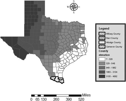
Located on the southernmost corner of Texas, the Lower Rio Grande Valley (LRGV) spans approximately 43,000 square miles, bordered by the Rio Grande River and Mexico to the west and south and the Gulf of Mexico to the east. It is comprised of four counties – Cameron, Hidalgo, Starr, and Willacy (see ).
Figure 1. Study Area: Lower Rio Grande Valley, Texas, U.S.A.
Flooding has long been a major issue in LRGV due to its low-lying lands and proximity to the Gulf of Mexico. Severe storms and flooding in 2018 and 2019 impacted over 5,000 residences in the region and resulted in about $59 million in individual assistance provided by FEMA (Citation2021b; Federal Emergency Management Agency, Citation2021a). Because of future climate variability, flooding events like these are more likely and will continue to present challenges. Moreover, continued urbanization and development pose flooding issues. The region has seen transformation from small, agricultural communities with acres of undeveloped land into suburban communities comprising the fifth-largest metropolitan area in Texas (Espey Consultants, Inc, Citation2011). While urbanization and associated impervious cover have contributed to the flooding problem, the prevalence of older developments and unincorporated colonias further complicate it with insufficient infrastructure for drainage (Espey Consultants, Inc, Citation2011; Uribe, Citation2017).
At the same time, the LGRV has a history of seasons of drought and has begun to face water shortages due to urbanization and agriculture expansion (Norwine, Giardino, & Krishnamurthy, Citation2005; Sanchez, Citation2022). The four-county region obtains a majority of its water supply from the Falcon-Amistad Lake/Reservoir System; currently, the Lake Falcon is only 9% full and Amistad is a 33% full (Baddour, Citation2022; Texas Water Development Board, Citationn.d.a, Citationn.d.c, Citationn.d.d, Citationn.d.e). Projections caution that water services to three million residents in South Texas will soon be severely constrained (Baddour, Citation2022). Heavy rainfall to recharge water sources and transporting water into the region are seen as the most viable solutions to current water shortages (Baddour, Citation2022).
3.1.1. Flood Mitigation Planning in the Study Area
The Disaster Mitigation Act of 2000 requires that all local jurisdictions have an approved Hazard Mitigation Plan (HMP) in order to be eligible for any federal funding opportunities (Jackman & Beruvides, Citation2013). In the state of Texas (as in all states in the U.S.), counties are required to prepare and adopt an HMP with the purpose of identifying, assessing, and reducing the long-term risk to life and property from hazard events (FEMA, Citation2011). Once county HMPs are approved, they must be updated every five years to maintain eligibility for various funding assistance. Updating an HMP entails reviewing and revising the plan to reflect changes in development, progress in local mitigation efforts and changes in priorities (FEMA, Citation2011).
In addition to County HMPs, the counties in the study area participate in regional planning efforts. In response to the impact of Hurricane Harvey and a number of devastating flood events across the state (Senate Research Center, Citation2019), the 86th Texas Legislature and Governor passed Senate Bill 8 on 10 June 2019 to create the first state flood plan. This legislation sets up a planning framework to support the development of updated flood risk products (e.g., floodplain maps and H&H models); enable regional participation and decision making in the planning process; and encourage the development of interventions with co-benefits, particularly with regard to water exceedance and supply (Lake, Citation2021). Administered by the Texas Water Development Board (TWDB), the state flood plan relies on regional watershed planning (Lake, Citation2021). Fifteen regions, corresponding to major river and coastal basins as delineated by TWDB, have been designated across the state (Texas Living Waters Project, Citationn.d..). Planning in these regions is coordinated by Regional Flood Planning Groups (RFPGs), comprised of 12 voting members, representing each of the following stakeholder groups: the public, agriculture, industry, river authorities, counties, municipalities, water districts, electric generating utilities, public water utilities, environmental interests, and small businesses (Senate Research Center, Citation2019).
In coordination with local stakeholders and technical advisors, RFPGs are tasked with assessing current flood mitigation strategies and policies as well as designating future projects based on these evaluations (Lake, Citation2021). According to Senate Bill 8:
A regional flood plan must: 1) use information based on scientific data and updated mapping; and 2) include: a) a general description of the condition and functionality of flood control infrastructure in the flood planning region; b) flood control projects under construction or in the planning stage; c) information on land use changes and population growth in the flood planning region; d) an identification of the areas in the flood planning region that are prone to flood and flood control solutions for those areas; and e) an indication of whether a particular flood control solution meets an emergency need, uses federal money as a funding component, and may also serve as a water supply source.
Flood planning in the LRGV is coordinated by the Region 15 RFPG. Region 15 covers over 43,000 square miles across 14 counties, eight of which are only partially included in the region (Lower Rio Grande Region 15 Regional Flood Planning Group , Citation2022). The entirety of Cameron, Hidalgo, Starr and Willacy Counties fall in the boundaries of Region 15.
To support regional flood mitigation, the 86th Texas Legislature also passed Senate Bill 7, designating $1.7 billion for flood control grants and loans (Anchondo, Citation2019). The bill created the Flood Infrastructure Fund (FIF), to be administered by TWDB, with a one-time appropriation of $793 million from the funds set aside by the bill (Lake, Citation2021). FIF awards provide grants and zero-percent interest loans to political jurisdictions for watershed planning; federal award matching funds; and structural (e.g., drainage systems, retention/detention infrastructure, levee networks) and non-structural (e.g., warning systems, public education) flood mitigation projects (Texas Water Development Board, Citation2020, September). To be eligible for funding, FIF projects must use the best and most recently available data and information; coordinate with local stakeholders impacted by the project; and not duplicate other projects (Lake, Citation2021). Once the state flood plan is in place in September 2024, only projects identified in the plan will be eligible for FIF funding (Lake, Citation2021).
The first round of FIF funding has committed (as of 31 May 2022) $405 million and supported 126 projects (Texas Water Development Board, Citationn.d.b). Priority was given to projects immediately protecting life and property and for watershed flood protection planning, to rural jurisdictions and to jurisdictions with a flood-related federal disaster declaration in last 5 years (Texas Water Development Board, Citation2020, September). FIF support totaling over $112 million has been committed to Cameron (totaling $45.9 million for 14 projects), Hidalgo (totaling $51.7 million for 6 projects), and Willacy (totaling $14.6 million for 14 projects) Counties, while Starr County has not been awarded FIF support (Texas Water Development Board, Citationn.d.b). The FIF projects in the study counties are predominantly a combination of flood control planning, acquisition, design, construction, and rehabilitation. Additionally, watershed and flood protection studies are also being undertaken in Cameron and Willacy Counties.
3.1.2. Planning Capacity of LRGV Counties
The LRGV region has a total population of 1.4 million persons of which 94% are Hispanic (RGV Health Connect, Citationn.d.b). It is home to some of the largest – and fastest growing – cities in the nation. It is projected that the population of the Valley will nearly double by 2045 (to 2.4 million) due to significant employment growth (Rio Grande Valley Metropolitan Planning Organization, 2020). The main industries of the region include agriculture, manufacturing, oil and gas, transportation, and, most recently, space exploration with a SpaceX launch facility in Brownsville, Cameron County (RGV Connect, 2022; Mann, Citation2022, April 23).
Since the early 1900s with the construction of railways and paved roads to connect the isolated region and irrigation canals to provide access to Rio Grande River water (Foscue, Citation1934), agriculture has been the dominant economic power in the LRGV. Employment is highly concentrated in agriculture work as well as personal and support services related to healthcare – all sectors with wages on the low-end of the scale (TIP Strategies, Inc., Citation2011). As a result of these employment trends and other socioeconomic legacies and patterns, socioeconomic vulnerability is high in the LRGV. Approximately 25% of the families live below the Texas poverty line (RGV Health Connect, Citationn.d.b). The average household income is $65,647, approximately $35,000 dollars below the average household income in Texas (RGV Health Connect, Citationn.d.a).
Socioeconomic vulnerability is particularly acute in the LGRV informal communities known as colonias and, more recently, model subdivisions (Barton, Perlmeter, Blum, et al., Citation2015; Durst & Ward, Citation2016). These communities, which now exceed 1,000 in number, emerged 70 years ago to meet the demand of affordable housing for low-income migrant workers (Barton, Perlmeter, Blum, et al., Citation2015). They have been developed on subdivided agriculture land with minimal or no basic infrastructure. Although state legislation passed in the late 1980s has required that subdivided land has water and wastewater services, there is a widespread lack of stormwater infrastructure to control flooding (Durst & Ward, Citation2016). As a result, these low-lying communities experience chronic flooding, and related public health issues, ranging from mosquito-borne diseases to the spread of toxic pesticides in floodwaters, are prevalent (Cantu-Pawlik, Citation2018).
reports the population characteristics for each county in the study area, compared to the average for all U.S. counties. In terms of population size, Cameron (423,029) and Hidalgo (880,356) Counties are significantly larger than the average U.S. county, while Starr (66,049) and Willacy (20,316) Counties are smaller. The study counties have populations that are younger than the average U.S. county, with larger percentages under 18 years and smaller proportions 65 years and older. With the exception of Willacy County, the study area has about the same gender profile as the average U.S. county. However, the study area population is predominantly Hispanic (88–96%), while this ethnic group comprises only 12% of the average U.S. county population. Median household income is lower in the study area, while poverty rates are higher − 24–25% in the study area compared 15% for the average U.S. county. Additionally, educational attainment in the study area lags behind national averages. Hidalgo and Cameron Counties have the most educated population with 19% and 18% holding a college degree; these fall slightly short of the 23% of the average U.S. county population that have a college education.
Table 1. County Population Characteristics.
As these demographic characteristics highlight, the study area is not representative of the average U.S. County. Relatively, the study area has low levels of human (e.g., educational attainment), financial (e.g., income and poverty rate) and physical (e.g., stormwater infrastructure) capitals, especially in the colonias. In terms of planning capacity, the study area is also weak.
Land use planning is ‘the single most promising approach for bringing about sustainable hazard mitigation’ (Burby, Deyle, Godschalk, et al., Citation2000, p. 99) and offers valuable processes and tools for climate change adaptation (P. R. Berke & Stevens, Citation2016). Land use planning involves gathering and analyzing information about the suitability of land development exposed to natural hazards so that limitations of development in hazard-prone areas are understood by citizens and the private sector (Burby, Deyle, Godschalk, et al., Citation2000). In the U.S., the land use planning decisions are made by local governments (Peña, Citation2002). In the state of Texas, land use tools, namely zoning, are under the control of municipal governments (Dahlstrom, Citation2013). Texas municipalities, when compared to others across the nation, have ‘unparalleled openness to growth and development’ (Puentes, Martin, & Pendall, Citation2006). County governments, therefore, have limited authority to wield planning tools to affect flood risk under high development and growth pressures. While the Texas legislature considered bills to empower counties to regulate building standards in 1995 and 2001, these attempts failed, leaving counties with limited planning capacity (Larson, Citation2002). In the LRGV, county-level planning capacity is further constrained by poor funding; limited authority and ability to provide adequate public services, especially to the most vulnerable populations including colonias; and weak connections across the public and private sectors (Atisa & Racelis, Citation2022; Ward, Citation1999).
Despite these capacity constraints, LRGV county governments have benefited from recent and substantial state FIF investments targeted at improving county and regional-level flood risk analysis and flood control planning. Furthermore, the state’s orientation to flood planning aligns with many of the central tenets of adaptive planning – more accurate risk information, participatory planning, and creating co-benefits of flood mitigation (Lake, Citation2021). Therefore, we believe this study area can serve as a testbed for resilience capacity building through adaptive planning. If state legislative mandates, investments, and guidance can provide the needed funding and incentives to improve regional flood planning, and then this study can tell us how adaptive planning – even an unlikely case – may be nurtured. Because capital deficiencies negatively affect how communities can withstand, respond, and recover from natural hazard emergencies and disasters (A. D. Ross, Citation2013; A. Ross & Clay, Citation2018), capacity building toward adaptive planning is critical to understand and nurture in other similarly resource-constrained communities.
3.2. Data
To explore adaptive planning in the LRGV, we collected two sets of texts that may be understood as outputs of planning institutions and processes: Corpus 1 – county and regional hazard and flood plans and Corpus 2 – regional flood planning group meeting transcripts. As content of formal hazard plans and planning discussions, we contend that these data adequately provide insights into the degree to which adaptive thinking is present or not for flood planning in the LRGV. These texts were collected in the language in which they were conducted, which is English. No Spanish language texts of the same type (i.e., plans) were available.
Hazard and flood plans were collected for the study area from local government and regional planning group websites. Specifically, we included in the analysis Cameron County Hazard Mitigation Action Plan Update of 2021, totalling 470 pages; Hidalgo County Hazard Mitigation Action Plan Update 2021, totalling 1021 pages; and Starr County Multi-Jurisdictional Hazard Mitigation Plan for 2019–2024, totalling 98 pages. A Hazard Mitigation Plan was not included for Willacy County as it was not available online and requests made to local officials were not responded to. In addition to the county hazard plans, the 2023 Regional Flood Draft Plan for Region 15 Lower Rio Grande Volume 1, totalling 223 pages, was included in the analysis. Volumes 2–4 of the regional plan were excluded as these include appendices with information beyond the scope of this analysis – maps, details on ongoing mitigation projects, and facts sheets with cost evaluations for proposed projects.
In addition to the planning documents, meeting recordings from the Region 15 Flood Planning Group were downloaded from the group’s website. Fifteen meetings, beginning with the group’s first meeting on 5 November 2020 and ending with the meeting held on 21 July 2022, were professionally transcribed. Approximately 24 hours of meeting discussion was transcribed into text for analysis using maching learning methods.
4. Methods
Natural Language Processing (NLP) is the branch of computer science, which is mainly focused on the use of artificial intelligence to provide machines with the ability to understand text and linguistic data, virtually the same way that humans do (Campesato, Citation2022). The presence of a plethora of information has made the process of manual topic extraction almost impossible, leading to an increased demand in automating this process (Campos, Mangaravite, Pasquali, et al., Citation2020). Under the umbrella of NLP methodology, topic modeling is the process of extracting the main keywords from vast bodies of linguistic data to identify major themes (Silge & Robinson, Citation2017).
Within the scholarship on natural hazards and disasters, the application of NLP and topic modeling has been used to explore effective and reliable disaster communication (Kaila & Rajesh, Citation2016), crisis communication requirements (Deng, Gao, Wang, et al., Citation2020), compound disasters (Malakar & Lu, Citation2022), pandemic response (Cuaton, Neo, & Neo, Citation2021), public opinion in various stages of disasters (Xu, Lachlan, Ellis, et al., Citation2019), identification of disaster risks (Gorro, Baguia, & Ali, Citation2021; Sakakibara, Mori, Chosokabe, et al., Citation2018), and post-disaster recovery needs (Jamali, Nejat, Ghosh, et al., Citation2019; Jamali, Nejat, Moradi, et al., Citation2020). Only recently has NLP and topic modeling been used in research to explore planning documents. Brinkley and Stahmer (Citation2021) pioneered the use of topic modeling in plan analysis to identify common areas of emphasis among Californian cities’ general plans, finding more than 60 topics. In a similar study of 100 Resilient Cities plans, Fu, Li, and Zhai (Citation2022) confirm that NLP techniques coincide with conventional content analysis and, thus, can be reliably used to explore plans, including those related to hazards and disasters. Further, the work by Lesnikowski, Belfer, Rodman, et al. (Citation2019) that applies topic modeling to the analysis of climate change policy speeches and meeting notes demonstrates the utility of NLP for data of that kind. Our study contributes to this line of research by exploring the text of hazard and flood plans (Corpus 1) as well as flood planning meeting discussion (Corpus 2) from the specific lens of adaptive planning.
For this study, we use used unsupervised keyword extraction for topic modeling purposes, which is less resource intensive than supervised methods. Under unsupervised keyword extraction methods, almost all algorithms follow the same sequence of tasks, which includes pre-processing, candidate generation, candidate scoring, post-processing and ranking (Campesato, Citation2022). We adopt Latent Dirichlet allocation (LDA) to fit a topic model where each item of a text corpus is modeled as a finite mixture over an underlying set of topics through a three-level hierarchical Bayesian model (Blei, Ng, & Jordan, Citation2003). Simply put, LDA finds the topics of co-occurring words that maximize the probability of generating the original collection of documents. In modeling the topics most common in the corpus, LDA provides an Intertopic Distance Map that shows how similar the topics are in relation to one another. The size of the mapped topic circles indicates the marginal topic distribution or the proportion of words that belong to each topic across the corpus. Per NLP conventions, before running the LDA analysis we cleaned the text by removing stop words, punctuations, other unmeaningful wordsFootnote1 and lemmatized to exclude similar words (Silge & Robinson, Citation2017).
5. Results
The objective of our analysis is to identify the topics of co-occurring words in two bodies of text that represent the outputs of flood planning institutions in the LRGV: Corpus 1 – county and regional hazard and flood plans and Corpus 2 – regional flood planning group meeting transcripts. The results of the LDA analysis for Corpus 1 are provided in . The Intertopic Distance Map is shown with five topics identified across two dimensions. The most salient and relevant words for each topic are listed in the table below the map. Salience refers to words that are most useful or informative for identifying a topic (Chuang, Manning, & Heer, Citation2012), while relevance indicates how much a word belongs to a topic in comparison to all the other topics (Sievert & Shirley, Citation2014).
Figure 2. LDA Results for Corpus 1 – Hazard & Flood Plans.
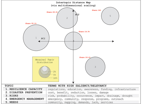
For Corpus 1, Topic 1, resilience capacity, spans a range of words that represent various community capacities to withstand, prevent, and manage a disaster event – ‘regulations,’ ‘education,’ ‘awareness,’ ‘funding’ and ‘infrastructure’ (A. D. Ross, Citation2013). Topic 2, disaster prevention, includes words that indicate cost–benefit evaluations of actions to prevent or reduce losses and damages – ‘cost,’ ‘benefit,’ ‘reduction,’ ‘losses’ and ‘damage.’ Topic 3, risks, encompasses mention of words that relate to the occurrence and severity of natural hazards – ‘risk,’ ‘probability,’ ‘occurrence’ and ‘impact’ – as well as words related to specific hazards in the study area – ‘drainage’ (related to flooding) and ‘drought.’ Topic 4, emergency management, covers words germane to this area of hazard management – ‘emergency,’ ‘community,’ ‘response,’ ‘programs,’ and ‘outreach.’ Topic 5, needs, includes words that we interpret as indicative of community needs for natural hazard risk reduction – ‘community,’ ‘mapping,’ ‘demands,’ ‘lack’ and ‘services.’
As shown by the size of the topic circles on the map for Corpus 1, Topics 1 and 2 – resilience capacity and disaster prevention – are the largest, meaning they include the largest share of words of the entire corpus. As shown by the placement of the topic circles on the map in relation to one another, Topics 1, 2 and 4 – resilience capacity, disaster prevention, and emergency management – have the most in common. Topics 3 and 5 – risks and needs – are more isolated, indicating that they share fewer common words in relation to the other topics.
The results of the LDA analysis for Corpus 2 are provided in . Topic 1, risk interpretation, spans a range of words that represent the process of decision makers making sense of hazard risk in their planning discussions – ‘risk,’ ‘floodplain,’ ‘conditions,’ ‘studies,’ ‘maps’ and ‘guidance.’ Topic 2, decision making, includes a wide range of words that taken together evoke the process of weighing costs and benefits for various public sector actions across the disaster cycle – ‘recommendation,’ ‘activities,’ ‘mitigation,’ ‘preparedness,’ ‘response,’ ‘cost,’ ‘benefit,’ ‘fees,’ ‘government’ and ‘jurisdictions.’ Topic 3, goals and strategies, includes words that demonstrate discussion about plan vision and strategies to achieve it – ‘goals,’ ‘strategies,’ ‘opportunities,’ ‘financing’ and ‘retrofitting.’ Topic 4, planning process, feature a set of words that we interpret as related to the process established by recent state legislation that leverages regional input and planning to develop a state-wide flood plan – ‘legislative,’ ‘regulatory,’ ‘administrative,’ ‘feedback’ and ‘changes.’ Topic 5, technical knowledge, includes a set of words that refer to the interpretation and evaluation of technical knowledge provided by the consultant group to the regional flood planning board – ‘meetings,’ ‘consultant,’ ‘understand,’ ‘fact’ and ‘gaps.’
Figure 3. LDA Results for Corpus 2 – Flood Planning Meeting Transcripts.
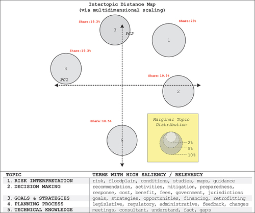
The topics for Corpus 2 are fairly balanced in terms of their share of words, spanning 19% (Topic 5 – technical knowledge) to 23% (Topic 1 – risk interpretation). In terms of commonality, Topics 1 and 2 – risk interpretation and decision making – are closely related, whereas Topic 5 – technical knowledge – is the most isolated. Overall, the topics in Corpus 2 are mostly independent of one another.
6. Discussion
The results of the analysis demonstrate that the central characteristics of adaptive planning – acceptance of uncertainty, inclusive public participation, and creation of co-benefits – are not the most dominant topics of the data analyzed for Corpus 1 (county and regional hazard and flood plans) and Corpus 2 (regional flood planning group meeting transcripts). Rather than approach hazards from a perspective of adaptation, there is a focus on disaster prevention (Topic 2 of Corpus 1), emergency management (Topic 4 of Corpus 1), and decision making around disaster mitigation, preparedness, and response (Topic 2 of Corpus 2). In fact, the word ‘adapt’ is largely absent from the County HMPs and Region 15 Flood Plan. Only in the Cameron County HMP section on mitigation actions does the word ‘adaptive’ appear in reference to a specific funded project to update the county-wide hydrologic and hydraulic (H&H) model. The Region 15 Flood Plan refers to ‘adapt’ once when defining community resilience as ‘a measure of the ability of a community to prepare for anticipated natural hazards, adapt to changing conditions, and withstand and recover rapidly from disruptions’ (Lower Rio Grande Region 15 Regional Flood Planning Group, Citation2022, p. 2–36). Instead, the plans appear to focus on their mission to protect against loss of life and property from flood (and other) hazards. While this goal is fundamental for hazard planning, it does not evoke, or necessarily require, adaptation or adaptive thinking.
6.1. Acceptance of uncertainty
The findings also show that rather than approach natural hazard planning with an acceptance of uncertainty, there is a focus on quantifying and interpreting risk (Topic 3 of Corpus 1 and Topic 1 of Corpus2). Yet, the risk considered by the plans and meeting transcripts analyzed do not fully account for future conditions. The county HMPs rely on historic data and records to make inferences about the likelihood of future events. The Region 15 Flood Plan adopts current flood conditions to approximate future risk by utilizing the existing 0.2% annual chance event (ACE) or ‘500-year flood’ area as a proxy for the future 1% ACE or ‘100-year’ or ‘base’ flood area. Further, in modeling flood hazards, the plan acknowledges that it does not ‘consider projected changes in rainfall patterns, future land use/population growth, or planned new/improved infrastructure’ (Lower Rio Grande Region 15 Regional Flood Planning Group , 2022, p. 2–4).
A recent study by Stults and Larsen (Citation2020), examining a sample of 60 local adaptation plans in the U.S., found that quantifying future climate conditions is the most common way to address hazard uncertainty. Forty-seven of the localities (78%) analysed used this technique but significantly fewer detailed dynamic strategies to address future risk; and 50% of the local plans specified adaptive management measures, while only 25% of the plans mentioned multiple timeframes. Like the plans evaluated in this study, the remaining plans were predominantly static in their handling of risk. As described by Walker and colleagues, the fundamental downfall of a static approach is that it is likely to fail:
Although policy analysts and strategic planners are aware that they are facing deep uncertainty, most of them still develop plans based on the assumption that the future can be predicted. They develop a static “optimal” plan using a single “most likely” future, often based on the extrapolation of trends, or a static “robust” plan that will produce acceptable outcomes in a small number of hypothesized future worlds. However, if the future turns out to be different from the hypothesized future(s), the plan is likely to fail.
6.2. Diverse participation
There is minimal emphasis on public participation in the results. The words ‘education,’ ‘awareness’ and ‘outreach’ only occur as part of resilience capacity (Topic 1 of Corpus 1) and emergency management (Topic 4 of Corpus 1), rather than emerging as a topic on their own. Stakeholders involved in the development of the County HMPs included county and city representatives as well as irrigation and school districts, in some cases. Additionally, multiple public engagement efforts were part of the planning process including open public meetings to discuss hazards, the planning process, and solicit input on plans; survey instruments to capture preferences for mitigation action and problem areas identified by the public and making the draft plan available for public review on participating jurisdictions’ websites.
The Region 15 RFPG is led by a multi-sector board, comprised of 14 voting members and 11 non-voting members. While the sectors included on the board were determined by the state and required of all RFPGs, it is notable that agriculture interests are represented by multiple voting and non-voting members in Region 15. Regarding public participation, the Region 15 RFPG has accepted written and public comments prior to and after all public meetings, of which there have been 14 since its inception in 2020 (Lower Rio Grande Region 15 Regional Flood Planning Group, Citation2018). A survey was also distributed among community representatives and residents to “determine the nature of flood risk in regions, evaluate flood mitigation and management practices, and identify projects that reduce flood risk without negatively affecting neighboring areas” (Lower Rio Grande Region 15 Regional Flood Planning Group , Citation2022). At the end of the planning period in 2022, public forums were planned in two locations in Region 15 to present and solicit public feedback on the draft flood plan.
While glimpses into the plans analyzed demonstrate there are multiple methods of public participation in the planning processes, it is not clear how inclusive these spaces were or what efforts were made to ensure access for all groups in the community. Research has found that even national adaptation plans typically do not include of a broad range of stakeholders in the planning process (Woodruff & Regan, Citation2019) and that there is a general lack of public interest in hazard adaptation (Berke & Lyles, Citation2013). Yet, diverse stakeholder participation is an integral part of the adaptive planning process because it serves as a mechanism of knowledge sharing required to fully address the social drivers of risk and design flexible and adaptive interventions to manage risk (Bosomworth & Gaillard, Citation2019). Such a participation requires more than the creation of a space for public input (Tschakert, Das, Pradhan, et al., Citation2016). It also requires an acknowledgement that adaptation decisions inherently exclude “some risks and actors’ interests while prioritizing others” (Eakin, Parajuli, Yogya, et al., Citation2021, p. 2); thus, structural inequities (e.g., power imbalances) and procedural justice (e.g., ability to participate) must be attended to ensure a pluralist process.
6.3. Development of Co-Benefits
While there is an indication of potential adaptive thinking present in the topic of goals and strategies (Topic 3 of Corpus 2), no evidence of consideration of co-benefits is found. One of the most logical places for this to occur is in the Region 15 Flood Plan. The state required that all regional flood plans include an assessment to describe if any strategy or project: ‘1) involves directly increasing “water supply” volume available during drought of record, which requires both availability increase and directly connecting supply to specific water user group(s) with an identified water supply need; 2) directly benefits “water availability” by, for example, injecting into aquifer but no one takes it as supply directly; 3) indirectly benefits “water availability” (e.g., indirectly recharges aquifers naturally)’ (Texas Water Development Board, Citation2021). Region 15 determined that there were no anticipated impacts from their flood plan strategies or projects on water supply or availability. It appears that opportunities were not fully explored for multiple benefits of flood projects, which is unfortunate in an area routinely stricken by the climate extremes of flood and drought. However, this is rather endemic of mitigation planning. Research has found multiple barriers to integrating adaptation benefits across systems including lack of awareness and coordination between departments, resource constraints to pursue projects with broad benefits, and differences in goals and perceived outcomes among coordinating departments (Boyd, Pathak, van Diemen, et al., Citation2022; Laukkonen, Blanco, Lenhart, et al., Citation2009; Wang, Citation2013).
7. Conclusion
This study has explored the degree to which local hazard mitigation plans in capacity-constrained communities of the LRGV in Texas have integrated adaptive planning attributes into recent flood plans. Because these plans were mandated by the state, we are able to also assess how traditional planning institutions may support adaptive planning. Thus, this study fills gaps in the scholarship on adaptive planning that has neglected to jointly evaluate the interdependent adaptive planning attributes of acceptance of uncertainty, diverse participation, and development of co-benefits – and assess how existing (and past) institutional legacies affect plan outputs (Scott, Shrestha, & Lutz Ley, Citation2020). This study also adds to the incipient body of research utilizing NLP to analyze hazard plans (Brinkley & Stahmer, Citation2021; Fu, Li, & Zhai, Citation2022).
The findings of our analyses indicate that key attributes of adaptive planning are largely absent for flood mitigation plans in the study area. This aligns with past studies that have found that management of risk by most local governments in the U.S. remains rooted in stationary hazard assessments (Stults & Larsen, Citation2020), fails to incentivize diverse participation (Berke & Lyles, Citation2013), and tends to neglect co-benefits possible with mitigation and adaptation (Wang, Citation2013). The findings also demonstrate that despite shifts in institutional environment to be more adaptive, significant re-adaptation challenges remain (Scott, Shrestha, & Lutz Ley, Citation2020). Specifically, limited technical capacity (e.g., lack of future flood risk data) and entrenched traditional approaches to hazard planning (e.g., lack of diverse public participation, disregard for adaptation co-benefits) among decision makers seem to constrain how much progress has been made toward adaptive planning in the study area. This is particularly troublesome as ‘lock-in’ situations could emerge in this underresourced region that restrict the pool of possible options and make communities even more vulnerable to unknown, future climate conditions (Bloemen, Reeder, Zevenbergen, et al., Citation2018; Haasnoot, Aalst, Rozenberg, et al., Citation2020; Hetz & Bruns, Citation2014). It also suggests that recent state investments made to improve planning capacity have fallen short.
Scholarship on adaptive planning implies that to change this trajectory, transformative political action is needed (Bloemen, Reeder, Zevenbergen, et al., Citation2018; O’donnell, Thorne, Ahilan, et al., Citation2020). We believe that such action must focus on enhancing the capacity of flood planning organizations and shifting organizational cultures from traditional (static optimal) to more adaptive (dynamic robust) thinking. Overcoming the present challenges in the study area cannot be achieved by institutional (legislative) change alone. Such a shift is important not only in the study area but also in other communities, ranging from rural counties across the nation to disaster-stricken areas, facing resource constraints and high levels of population vulnerability.
Future research should continue to explore how resource-constrained local governments pursue adaptive planning as climate change intensifies and hazard profiles shift. Critically, it is important to further investigate how institutions on the state, regional and federal level can enable local adaptation. While this study has demonstrated the utility of NLP and topic modelling for the examination of local adaptation plans, we acknowledge that this methodology has limitations including fluctuations in performance and human bias inherent to content analysis (Fu, Li, & Zhai, Citation2022). Therefore, it is important that future work explore the use of NLP in other settings and cases as well as evaluate local adaptation planning using other methodologies.
Supplemental Material
Download MS Word (13.4 KB)Acknowledgments
The authors would like to acknowledge Laura Button for her contribution to this paper through the National Science Foundation's Ocean and Coastal Research Experiences for Undergraduates (OCEANUS) program at Texas A&M University at Galveston during the summer 2022.
Supplemental data
Supplemental data for this article can be accessed online at https://doi.org/10.1080/23789689.2023.2180249.
Disclosure statement
No potential conflict of interest was reported by the authors.
Data availability statement
Data is available from DesignSafe-CI: https://doi.org/10.17603/ds2-5x0c-2v08 v1
Additional information
Funding
Notes on contributors
Ashley D. Ross
Ashley D. Ross is an Associate Professor at Texas A&M University at Galveston in the Department of Marine and Coastal Environmental Science. Her research interests include community disaster resilience, hazards governance, and coastal community resilience.
Ali Nejat
Ali Nejat is an Associate Professor of Construction Engineering at Texas Tech University. His research interests include modeling the dynamics of post-disaster housing and household recovery, infrastructure management, and system dynamics.
Virgie Greb
Virgie Greb is a doctoral student in the Marine and Coastal Management and Science program at Texas A&M University at Galveston. Her research interests include social-ecological resilience and hazards management.
Notes
1. See Appendix A for list of words removed from the analysis.
References
- Anchondo, C. (2019). Legislation with $1.7 billion for flood control and mitigation projects goes to governor. Texas Tribune. https://www.texastribune.org/2019/05/26/lawmakers-approve-bill-to-help-fund-floor-control-projects-in-texas/
- Atisa, G., & Racelis, A. E. (2022). Analysis of urbanization and climate change effects on community resilience in the Rio Grande Valley, South Texas. Sustainability, 14(15). Article 15. https://doi.org/10.3390/su14159049.
- Babovic, F., & Mijic, A. (2019). The development of adaptation pathways for the long-term planning of urban drainage systems. Journal of Flood Risk Management, 12(S2), 12538. https://doi.org/10.1111/jfr3.12538
- Baddour, D. (2022, August 16). Drought and record-breaking heat spur a South Texas water crisis. The Texas Tribune. https://www.texastribune.org/2022/08/16/south-texas-water-drought/
- Barton, J., Perlmeter, E. R., Blum, E. S., & Márquez, R. R. (2015). Las colonias along the texas-mexico border. In P. M. Orrenius, J. Cañas, & M. Weiss (Eds.), Ten-Gallon Economy: Sizing Up Economic Growth in Texas (pp. 213–229). Palgrave Macmillan US. https://doi.org/10.1057/9781137530172_14
- Berke, P., & Lyles, W. (2013). Public risks and the challenges to climate-change adaptation: a proposed framework for planning in the age of uncertainty. Cityscape, 15(1), 181–208.
- Berke, P. R., & Stevens, M. R. (2016). Land Use Planning for Climate Adaptation: Theory and Practice. Journal of Planning Education and Research, 36(3), 283–289. https://doi.org/10.1177/0739456X16660714
- Berrang-Ford, L., Ford, J. D., & Paterson, J. (2011). Are we adapting to climate change? Global Environmental Change, 21(1), 25–33. https://doi.org/10.1016/j.gloenvcha.2010.09.012
- Blei, D. M., Ng, A. Y., & Jordan, M. I. (2003). Latent Dirichlet allocation. Journal of Machine Learning Research, 3(Jan), 993–1022.
- Bloemen, P., Reeder, T., Zevenbergen, C., Rijke, J., & Kingsborough, A. (2018). Lessons learned from applying adaptation pathways in flood risk management and challenges for the further development of this approach. Mitigation and Adaptation Strategies for Global Change, 23(7), 1083–1108. https://doi.org/10.1007/s11027-017-9773-9
- Bosomworth, K., & Gaillard, E. (2019). Engaging with uncertainty and ambiguity through participatory ‘Adaptive Pathways’ approaches: Scoping the literature. Environmental Research Letters, 14(9), 093007. https://doi.org/10.1088/1748-9326/ab3095
- Boyd, D., Pathak, M., van Diemen, R., & Skea, J. (2022). Mitigation co-benefits of climate change adaptation: A case-study analysis of eight cities. Sustainable Cities and Society, 77, 103563. https://doi.org/10.1016/j.scs.2021.103563
- Brinkley, C., & Stahmer, C. (2021). What is in a plan? Using natural language processing to read 461 California city general plans. Journal of Planning Education and Research, 0739456X(21995890), 0739456X2199589. https://doi.org/10.1177/0739456X21995890
- Burby, R. J., Deyle, R. E., Godschalk, D. R., & Olshansky, R. B. (2000). Creating Hazard Resilient Communities through Land-Use Planning. Natural Hazards Review, 1(2), 99–106. https://doi.org/10.1061/(ASCE)1527-6988(2000)1:2(99)
- Buurman, J., & Babovic, V. (2014, November 27). Design of Adaptive Policy Pathways under Deep Uncertainties an Approach to Climate Change Adaptation. Agility and Resilience in Policy-Making: Coping with Uncertainty and Ambiguity International Conference on Uncertainty and Policy Design, Chengdu, China.
- Campesato, O. (2022). Natural Language Processing Using R Pocket Primer. Mercury Learning and Information.
- Campos, R., Mangaravite, V., Pasquali, A., Jorge, A., Nunes, C., & Jatowt, A. (2020). YAKE! Keyword extraction from single documents using multiple local features. Information Sciences, 509, 257–289. https://doi.org/10.1016/j.ins.2019.09.013
- Cantu-Pawlik, S. (2018, July 12). Colonias: A Public Health Crisis on the Texas-Mexico Border. Salud America. https://salud-america.org/colonias-a-public-health-crisis-on-the-texas-mexico-border/
- Chuang, J., Manning, C. D., & Heer, J. (2012). Termite: Visualization techniques for assessing textual topic models. Proceedings of the International Working Conference on Advanced Visual Interfaces, 74–77. https://doi.org/10.1145/2254556.2254572
- Congressional Research Service. (2022). Recent Funding Increases for FEMA Hazard (CRS Insight Prepared for Members and Committees of Congress No. IN11733). https://crsreports.congress.gov
- Cosens, B. A., & Williams, M. K. (2012). Resilience and Water Governance: Adaptive Governance in the Columbia River Basin. Ecology and Society, 17(4). https://doi.org/10.5751/ES-04986-170403
- Cuaton, G. P., Neo, J. F. V., & Neo, J. F. V. (2021). A topic modeling analysis on the early phase of COVID-19 response in the Philippines. International Journal of Disaster Risk Reduction, 61, 102367. https://doi.org/10.1016/j.ijdrr.2021.102367
- Dahlstrom, W. (2013). Chapter 4: Zoning Regulations in Texas. In A Guide to Urban Planning in Texas Communities 2013. American Planning Association, 137–158 .
- Deng, Q., Gao, Y., Wang, C., & Zhang, H. (2020). Detecting information requirements for crisis communication from social media data: An interactive topic modeling approach. International Journal of Disaster Risk Reduction, 50, 101692. https://doi.org/10.1016/j.ijdrr.2020.101692
- Dessai, S., Hulme, M., Lempert, R., & Pielke, R., Jr. (2009). Do We Need Better Predictions to Adapt to a Changing Climate? Eos, Transactions American Geophysical Union, 90(13), 111–112. https://doi.org/10.1029/2009EO130003
- Dovers, S. (2009). Normalizing adaptation. Global Environmental Change, 19(1), 4–6. https://doi.org/10.1016/j.gloenvcha.2008.06.006
- Durst, N. J., & Ward, P. M. (2016). Colonia Housing Conditions in Model Subdivisions: A Déjà Vu for Policy Makers. Housing Policy Debate, 26(2), 316–333. https://doi.org/10.1080/10511482.2015.1068826
- Eakin, H., Parajuli, J., Yogya, Y., Hernández, B., & Manheim, M. (2021). Entry points for addressing justice and politics in urban flood adaptation decision making. Current Opinion in Environmental Sustainability, 51, 1–6. https://doi.org/10.1016/j.cosust.2021.01.001
- Eriksen, S., & Lind, J. (2009). Adaptation as a Political Process: Adjusting to Drought and Conflict in Kenya’s Drylands. Environmental Management, 43(5), 817–835. https://doi.org/10.1007/s00267-008-9189-0
- Eriksen, S. H., Nightingale, A. J., & Eakin, H. (2015). Reframing adaptation: The political nature of climate change adaptation. Global Environmental Change, 35, 523–533. https://doi.org/10.1016/j.gloenvcha.2015.09.014
- Espey Consultants, Inc. (2011). City of La Feria Flood Protection Plan Engineering Report (p. 232). https://www.twdb.texas.gov/publications/reports/contracted_reports/doc/0904830949_laFeria.pdf
- Federal Emergency Management Agency. (2021a, April 21). 4377 | FEMA.gov. https://www.fema.gov/disaster/4377-0
- Federal Emergency Management Agency. (2021b, July 18). 4454 | FEMA.gov. https://www.fema.gov/disaster/4454
- FEMA. (2011). Local Mitigation Plan Review Guide. https://www.fema.gov/sites/default/files/2020-06/fema-local-mitigation-plan-review-guide_09_30_2011.pdf
- Foscue, E. J. (1934). Agricultural History of the Lower Rio Grande Valley Region. Agricultural History, 8(3), 124–137. https://doi.org/10.2307/209631
- Fothergill, A., Maestas, E. G., & Darlington, J. D. (1999). Race, ethnicity and disasters in the United States: A review of the literature. Disasters, 23(2), 156–173. https://doi.org/10.1111/1467-7717.00111
- Fu, X., Li, C., & Zhai, W. (2022). Using Natural Language Processing to Read Plans. Journal of the American Planning Association, 0(0), 1–12. https://doi.org/10.1080/01944363.2022.2038659
- Funtowicz, S., & Ravetz, J. (2020). Chapter 2 - Post-Normal Science: How Does It Resonate with the World of Today? In V. Šucha & M. Sienkiewicz (Eds.), Science for Policy Handbook (pp. 14–18). Elsevier. https://doi.org/10.1016/B978-0-12-822596-7.00002-4
- Garmestani, A., & Benson, M. (2013). A Framework for Resilience-based Governance of Social-Ecological Systems. Ecology and Society, 18(1). https://doi.org/10.5751/ES-05180-180109
- Gorro, K. D., Baguia, G. A., & Ali, M. F. (2021). An analysis of Disaster Risk Suggestions using Latent Dirichlet Allocation and Hierarchical Dirichlet Process (Nonparametric LDA). The 9th International Conference on Information Technology: IoT and Smart City, Guangzhou, China, 181–184.
- Haasnoot, M., Aalst, M., Rozenberg, J., Dominique, K., Matthews, J., Bouwer, L. M., Poff, N. L., & Poff, N. L. (2020). Investments under non-stationarity: Economic evaluation of adaptation pathways. Climatic Change, 161(3), 451–463. https://doi.org/10.1007/s10584-019-02409-6
- Haasnoot, M., Kwakkel, J. H., Walker, W. E., & Ter Maat, J. (2013). Dynamic adaptive policy pathways: A method for crafting robust decisions for a deeply uncertain world. Global Environmental Change, 23(2), 485–498. https://doi.org/10.1016/j.gloenvcha.2012.12.006
- Haasnoot, M., Middelkoop, H., Beek, E., & Deursen, W. P. A. (2011). A method to develop sustainable water management strategies for an uncertain future. Sustainable Development, 19(6), 369–381. https://doi.org/10.1002/sd.438
- Hasselman, L. (2017). Adaptive management; adaptive co-management; adaptive governance: What’s the difference? Australasian Journal of Environmental Management, 24(1), 31–46. https://doi.org/10.1080/14486563.2016.1251857
- Hetz, K., & Bruns, A. (2014). Urban planning lock-in: Implications for the realization of adaptive options towards climate change risks. Water International, 39(6), 884–900. https://doi.org/10.1080/02508060.2014.962679
- Holling, C. S. (1978). Adaptive Environmental Assessment and Management. John Wiley & Sons. https://iiasa.dev.local/
- Intergovernmental Panel Climate Change. (2018). Global Warming of 1.5°C. An IPCC Special Report on the impacts of global warming of 1.5°C above pre-industrial levels and related global greenhouse gas emission pathways, in the context of strengthening the global response to the threat of climate change, sustainable development, and efforts to eradicate poverty. Cambridge University Press.
- Intergovernmental Panel Climate Change Climate Change. (2007). Climate Change 2007: Synthesis Report. Contribution of Working Groups I, II and III to the Fourth Assessment Report of the Intergovernmental Panel on Climate Change. IPCC.
- Jackman, A. M., & Beruvides, M. G. (2013). Hazard Mitigation Planning in the United States: Historical Perspectives, Cultural Influences, and Current Challenges. In J. Tiefenbacher (ed.), Approaches to Disaster Management - Examining the Implications of Hazards, Emergencies and Disasters. InTechOpen. https://www.intechopen.com/chapters/44223.
- Jamali, M., Nejat, A., Ghosh, S., Jin, F., & Cao, G. (2019). Social media data and post-disaster recovery. International Journal of Information Management, 44, 25–37. https://doi.org/10.1016/j.ijinfomgt.2018.09.005
- Jamali, M., Nejat, A., Moradi, S., Ghosh, S., Cao, G., & Jin, F. (2020). Social media data and housing recovery following extreme natural hazards. International Journal of Disaster Risk Reduction, 51, 101788. https://doi.org/10.1016/j.ijdrr.2020.101788
- Kaila, P., & Rajesh, D. (2016). An Empirical Text Mining Analysis of Fort McMurray Wildfire Disaster Twitter Communication using Topic Model ( SSRN Scholarly Paper No. 3710307). https://papers.ssrn.com/abstract=3710307
- Lake, P. (2021). Texas Reimagines the Fight Against Floods. Texas Water Journal, 12(1), 58–67. https://doi.org/10.21423/TWJ.V12I1.7133
- Larson, J. E. (2002). Informality, Illegality, and Inequality. Yale Law & Policy Review, 20(1), 137–182.
- Laukkonen, J., Blanco, P. K., Lenhart, J., Keiner, M., Cavric, B., & Kinuthia-Njenga, C. (2009). Combining climate change adaptation and mitigation measures at the local level. Habitat International, 33(3), 287–292. https://doi.org/10.1016/j.habitatint.2008.10.003
- Lawrence, J., Bell, R., & Stroombergen, A. (2019). A hybrid process to address uncertainty and changing climate risk in coastal areas using dynamic adaptive pathways planning, multi-criteria decision analysis & real options analysis: A New Zealand application. Sustainability, 11(2), 406. https://doi.org/10.3390/su11020406
- Lawrence, J., & Haasnoot, M. (2017). What it took to catalyse uptake of dynamic adaptive pathways planning to address climate change uncertainty. Environmental Science & Policy, 68, 47–57. https://doi.org/10.1016/j.envsci.2016.12.003
- Lesnikowski, A., Belfer, E., Rodman, E., Smith, J., Biesbroek, R., Wilkerson, J. D., & Berrang-ford, L. (2019). Frontiers in data analytics for adaptation research: Topic modeling. Wiley Interdisciplinary Reviews Climate Change, 10(3), 576. https://doi.org/10.1002/wcc.576
- Lower Rio Grande Region 15 Regional Flood Planning Group. (2022). Region 15 RFP Draft_Volume 1.pdf. http://www.region15lrg.org/upload/page/0071/docs/Region%2015%20RFP%20Draft_Volume%201.pdf
- Malakar, K., & Lu, C. (2022). Hydrometeorological disasters during COVID-19: Insights from topic modeling of global aid reports. The Science of the Total Environment, 155977, 155977. https://doi.org/10.1016/j.scitotenv.2022.155977
- Mann, J. (2022, April 23). SpaceX has become the largest employer in Brownsville, Texas, and estimates $885 million gross output for the county it’s based in, reports say. Business Insider. https://www.businessinsider.com/spacex-largest-employer-texas-brownsville-2022-4
- Manocha, N., & Babovic, V. (2018). Real options, multi-objective optimization and the development of dynamically robust adaptive pathways. Environmental Science & Policy, 90, 11–18. https://doi.org/10.1016/j.envsci.2018.09.012
- Norwine, J., Giardino, J. R., & Krishnamurthy, S. (2005). Water for Texas. Texas A&M University Press.
- O’donnell, E., Thorne, C., Ahilan, S., Arthur, S., Birkinshaw, S., Butler, D., Wright, N., Everett, G., Fenner, R., Glenis, V., Kapetas, L., Kilsby, C., Krivtsov, V., Lamond, J., Maskrey, S., O’Donnell, G., Potter, K., Vercruysse, K., Vilcan, T., & Wright, N. (2020). The blue-green path to urban flood resilience. Blue-Green Systems, 2(1), 28–45. https://doi.org/10.2166/bgs.2019.199
- Peña, S. (2002). Land use planning on the U.S.- Mexico border: A comparison of the legal framework. Journal of Borderlands Studies, 17(1), 1–19. https://doi.org/10.1080/08865655.2002.9695579
- Puentes, R., Martin, J., & Pendall, R. (2006). From Traditional to Reformed: A Review of the Land Use Regulations in the Nation’s 50 largest Metropolitan Areas. https://www.brookings.edu/research/from-traditional-to-reformed-a-review-of-the-land-use-regulations-in-the-nations-50-largest-metropolitan-areas/
- Ranger, N., Millner, A., Dietz, S., Fankhauser, S., Lopez, A., & Ruta, G. (2010). Adaptation in the UK: A decision-making process. Grantham Research Institute on Climate Change and the Environment and Center for Climate Change Economics and Policy.
- RGV Health Connect. (n.d.a). RGV Health Connect: Demographics: Region: Rio Grande Valley: Households/Income. Retrieved October 11, 2022, from https://www.rgvhealthconnect.org/demographicdata?id=281259§ionId=936
- RGV Health Connect. (n.d.b). RGV Health Connect: Demographics: Region: Rio Grande Valley: Population. Retrieved October 11, 2022, from https://www.rgvhealthconnect.org/demographicdata?id=281259§ionId=935
- Rosa, M. P. (2008). Towards an adaptive approach in planning and management process. In Meire, P, Coenen, M, Lombardo, C, Robba, M, Sacile, R (Eds.), Integrated Water Management (pp. 23–32). Springer Netherlands.
- Ross, A. D. (2013). Local Disaster Resilience: Administrative and Political Perspectives. Routledge. https://doi.org/10.4324/9780203551912
- Ross, A., & Clay, L. A. (2018). Capital Assets and Rural Resilience: An Analysis of Texas Communities Impacted by Hurricane Harvey. Journal of Natural Resources Policy Research, 8(1–2), 154–186. https://doi.org/10.5325/naturesopolirese.8.1-2.0154
- Ruhl, J. B. (2010). General Design Principles for Resilience and Adaptive Capacity in Legal Systems—With Applications to Climate Change Adaptation. North Carolina Law Review, 89, 1373.
- Runhaar, H., Mees, H., Wardekker, A., Sluijs, J., & Driessen, P. P. (2012). Adaptation to climate change-related risks in Dutch urban areas: Stimuli and barriers. Regional Environmental Change, 12(4), 777–790. https://doi.org/10.1007/s10113-012-0292-7
- Sakakibara, H., Mori, S., Chosokabe, M., Kamiya, D., Yamanaka, R., Miyaguni, T., & Tsukai, M. (2018). The Topic Extraction from the Discussion Data of Community Disaster Risk Management Workshops. 2018 IEEE International Conference on Systems, Man, and Cybernetics (SMC), Miyazaki, Japan, 462–467.
- Sanchez, S. (2022, August 4). Water restrictions ordered in Rio Grande Valley as drought persists | KVEO-TV. ValleyCentral.Com. https://www.valleycentral.com/news/water-restrictions-ordered-in-rio-grande-valley-as-drought-persists/
- Scott, C. A., Shrestha, P. P., & Lutz Ley, A. N. (2020). The re-adaptation challenge: Limits and opportunities of existing infrastructure and institutions in adaptive water governance. Current Opinion in Environmental Sustainability, 44, 104–112. https://doi.org/10.1016/j.cosust.2020.09.012
- Senate Research Center. (2019). Bill Analysis, Senate Bill 8, 86th Legislature, Regular Session. https://capitol.texas.gov/tlodocs/86R/analysis/pdf/SB00008I.pdf#navpanes=0
- Sievert, C., & Shirley, K. (2014). Ldavis: A method for visualizing and interpreting topics. Proceedings of the Workshop on Interactive Language Learning, Visualization, and Interfaces, Baltimore, Maryland, 63–70.
- Silge, J., & Robinson, D. (2017). Text mining with R: A tidy approach. O’Reilly Media, Inc.
- Stults, M., & Larsen, L. (2020). Tackling Uncertainty in US Local Climate Adaptation Planning. Journal of Planning Education and Research, 40(4), 416–431. https://doi.org/10.1177/0739456X18769134
- Tate, E., Rahman, M. A., Emrich, C. T., & Sampson, C. C. (2021). Flood exposure and social vulnerability in the United States. Natural Hazards, 106(1), 435–457. https://doi.org/10.1007/s11069-020-04470-2
- Tellman, B., Bausch, J., Eakin, H., Anderies, J., Mazari-Hiriart, M., Manuel-Navarrete, D., & Redman, C. (2018). Adaptive pathways and coupled infrastructure: Seven centuries of adaptation to water risk and the production of vulnerability in Mexico City. Ecology and Society, 23(1). https://doi.org/10.5751/ES-09712-230101
- Texas Living Waters Project. (n.d.) Texas State and Regional Planning. https://texaslivingwaters.org/deeper-dive/rfpg_factsheet/
- Texas Water Development Board. (2020, September). 2020 Flood Intended Use Plan. https://www.twdb.texas.gov/financial/programs/fif/doc/2020_Flood_Intended_Use_Plan.pdf.
- Texas Water Development Board. (2021, April). Technical Guidelines for Regional Flood Planning. https://www.twdb.texas.gov/flood/planning/planningdocu/2023/doc/04_Exhibit_C_TechnicalGuidelines_April2021.pdf
- Texas Water Development Board. (n.d.a). Cameron County | 2022 Texas State Water Plan. Retrieved October 12, 2022, from https://texasstatewaterplan.org/county/Cameron
- Texas Water Development Board. (n.d.b). Flood Infrastructure Fund (FIF) | Texas Water Development Board. Retrieved October 12, 2022, from https://www.twdb.texas.gov/financial/programs/fif/index.asp
- Texas Water Development Board. (n.d.c). Hidalgo County | 2022 Texas State Water Plan. Retrieved October 12, 2022, from https://texasstatewaterplan.org/county/Hidalgo
- Texas Water Development Board. (n.d.d). Starr County | 2022 Texas State Water Plan. Retrieved October 12, 2022, from https://texasstatewaterplan.org/county/Starr
- Texas Water Development Board. (n.d.e). Willacy County | 2022 Texas State Water Plan. Retrieved October 12, 2022, from https://texasstatewaterplan.org/county/Willacy
- Thomas, K., Hardy, R. D., Lazrus, H., Mendez, M., Orlove, B., Rivera-collazo, I., Winthrop, R., Rockman, M., Warner, B. P., & Winthrop, R. (2019). Explaining differential vulnerability to climate change: A social science review. Wiley Interdisciplinary Reviews Climate Change, 10(2), 565. https://doi.org/10.1002/wcc.565
- TIP Strategies, Inc. (2011, January). An Economic Strategy for the Lower Rio Grande Valley. https://wfsolutions.org/images/workforce/GeneralWebsite/Content/WhoWeAre/Resources/TIPReports/TIPS_Regional_Collaboration_Project_Final_Report_2011.pdf
- Tompkins, E. L., & Eakin, H. (2012). Managing private and public adaptation to climate change. Global Environmental Change, 22(1), 3–11. https://doi.org/10.1016/j.gloenvcha.2011.09.010
- Tschakert, P., Das, P. J., Pradhan, N. S., Machado, M., Lamadrid, A., Buragohain, M., & Hazarika, M. A. (2016). Micropolitics in collective learning spaces for adaptive decision making. Global Environmental Change, 40, 182–194. https://doi.org/10.1016/j.gloenvcha.2016.07.004
- Uribe, M. E. G. (2017). Flood Risk Areas in the Rio Grande Valley Colonias [GIS for Water Resources Fall 2017, The University of Texas at Austin]. https://www.caee.utexas.edu/prof/maidment/giswr2017/TermProject/FinalReports/MonicaGuerraUribe.pdf
- Walker, W. E., Haasnoot, M., & Kwakkel, J. H. (2013). Adapt or perish: A review of planning approaches for adaptation under deep uncertainty. Sustainability, 5(3), 955–979. https://doi.org/10.3390/su5030955
- Walker, W. E., Rahman, S. A., & Cave, J. (2001). Adaptive policies, policy analysis, and policy-making. European Journal of Operational Research, 128(2), 282–289. https://doi.org/10.1016/S0377-2217(00)00071-0
- Wang, R. (2013). Adopting Local Climate Policies: What Have California Cities Done and Why? Urban Affairs Review, 49(4), 593–613. https://doi.org/10.1177/1078087412469348
- Ward, P. M. (1999). Colonias and Public Policy in Texas and Mexico: Urbanization by Stealth. University of Texas Press. https://www.jstor.org/stable/10.7560/791244
- Woodruff, S. C., & Regan, P. (2019). Quality of national adaptation plans and opportunities for improvement. Mitigation and Adaptation Strategies for Global Change, 24(1), 53–71. https://doi.org/10.1007/s11027-018-9794-z
- Xu, Z., Lachlan, K., Ellis, L., & Rainear, A. M. (2019). Understanding public opinion in different disaster stages: A case study of Hurricane Irma. Internet Research, 30(2), 695–709. https://doi.org/10.1108/INTR-12-2018-0517