
Abstract
Residential population data are frequently employed to link the crime incidence of an area with the number of residents to estimate the underlying risk. Human mobility patterns cause shifts in the baseline population, however, that can potentially influence the crime statistics. This study therefore employed an ambient population that combined residential population data with data depicting the commuting activity in small administrative areas. The effects of the commuter-harmonized ambient population on crime were then evaluated in a series of negative binomial regression models. The models also controlled for criminogenic factors and incorporated eigenvector spatial filtering to adjust for spatial effects. The results show significant effects of commuting patterns on crime outcomes. For certain crimes, such as violence, theft, and disorder, the inbound commuters are significantly associated with high risk. It was further discovered that an offset variable comprising the commuter-harmonized ambient population data models the crime outcomes more reliably than when residential population data are used. Spatial filtering was found to effectively eradicate residual spatial autocorrelation after accounting for effects of the predictor variables. We conclude that calculating crime rates using the residential population does not constitute an accurate risk measure and that the ambient population has crucial implications for realistic and reliable target representation and crime modeling.
居住人口数据经常用来连结一地的犯罪事件与常住人口数, 以评估潜在的风险。但人类的移动模式, 导致可能会影响犯罪统计的基线人口的转移。本研究因此运用结合小型行政区域居住人口数据和描绘通勤活动数据的周遭人口。本研究接着在负二项迴归模型的系列中, 评估调和勤者的周遭人口对犯罪的影响。这些模型同时控制犯罪因素, 并纳入特徵向量空间过滤, 以调整空间效应。研究结果显示通勤模式对于犯罪结果的显着影响。就暴力、偷窃和扰乱等若干犯罪而言, 向内的通勤者与高风险显着相关。本研究进一步发现, 包含调和通勤者周遭人口数据的偏移变量, 较运用居住人口数据所进行的模型化犯罪后果更佳可靠。本研究发现, 考量预测变项之后, 空间过滤能有效地根除空间自相关的残馀。我们于结论中指出, 运用常住人口来计算犯罪率, 无法组成准确的风险评估, 而周遭人口对于实际且可靠的目标再现与犯罪模式化而言具有重要的意涵。
Frecuentemente los datos de población residencial se utilizan para conectar la incidencia del crimen sobre un área con el número de residentes para calcular el riesgo subyacente. Sin embargo, los patrones de movilidad humana causan cambios en la población de referencia que potencialmente pueden influir las estadísticas de la criminalidad. Es por eso por lo que este estudio utilizó una población momentánea que combinó los datos de población residencial con los datos que representan la actividad de los viajes pendulares en áreas administrativas pequeñas. Los efectos de la población momentánea armonizada por el conmutante sobre el crimen fueron luego evaluados en una serie de modelos de regresión negativa. Los modelos controlaron también los factores criminogénicos e incorporaron el filtrado espacial eigenvector para hacer ajustes en razón de efectos espaciales. Los resultados muestran efectos significativos de los patrones del viaje pendular sobre la criminalidad resultante. En lo que se refiere a ciertos crímenes, como violencia, robo y alteraciones del orden, los conmutantes o viajeros pendulares orientados hacia adentro aparecen significativamente asociados con riesgo alto. Se descubrió además que una variable compensadora que comprenda los datos de población momentánea armonizada por el conmutante modela los crímenes resultantes de manera más fiable que cuando son utilizados los datos de la población residencial. Se halló que el filtrado espacial efectivamente erradicaba la autocorrelación espacial residual tras tomar en cuenta los efectos de las variables predictivas. Concluimos que calcular las tasas de crimen usando la población residencial no constituye una medida exacta de riesgo y que la población momentánea tiene implicaciones cruciales para una representación proyectada realista y confiable, y para la modelación criminalística.
An essential prerequisite for determining crime-related hazards is to identify variables that increase the accuracy for estimating risk (Chainey and Ratcliffe Citation2013; Ceccato Citation2015). Residential population data are frequently used for target estimation, because these data are usually available from censuses (e.g., Sampson, Raudenbush, and Earls Citation1997; Sutherland, Brunton-Smith, and Jackson Citation2013; He et al. Citation2015). Nevertheless, several reasons make these data theoretically insufficient for estimating the crime variation and crime targets or for ranking areas by criminality (Boggs Citation1965; Andresen Citation2011; Andresen, Jenion, and Reid Citation2012).
First, census data commonly denote the number of nighttime residents of an area, but this number rises and falls due to the daily human activity occurring outside the boundaries of census units (Andresen and Jenion Citation2008; Kwan Citation2012; Stults and Hasbrouck Citation2015). The shifts in population arising from the imbalance in the number of inbound and outbound commuters might artificially influence the estimation and cause inferential errors. Second, the theory of routine activity (Cohen and Felson Citation1979) holds that crime emanates from offender–target interaction when the guardians are absent. Thus, commuting affords opportunities for individuals to interact beyond the boundaries of the census areas (Stults and Hasbrouck Citation2015). Such interaction allows the perpetrators of certain crimes (e.g., theft, violence) to discover suitable targets among the mobile residents. Therefore, the influence of mobility on risk must not be overlooked. Third, Malleson, Heppenstall, and See (Citation2010) proposed that the offending group is not necessarily unemployed. It is further argued that opportunities to offend will often emerge in the course of traveling to and from places of daily engagement, such as work (Brantingham and Brantingham Citation1981). Finally, workers and criminals both incur costs during travel, costs that they attempt to minimize (Brantingham and Brantingham Citation1984; Carter and Hill Citation2014; Vandeviver, Van Daele, and Vander Beken Citation2014). Employees in urban areas often live remotely from their places of work, such as in the immediate city suburbs, to manage housing expenses (Helbich and Leitner Citation2009). Similarly, the pursuit of cover and greater opportunities leads criminals to offend at a distance from their homes (Mburu and Helbich Citation2015). Thus, the cost-avoidance propensity and the interaction of offenders and commuting workers culminate in increased crime incidence, particularly in small areas (Farley and Hansel Citation1981; Stults and Hasbrouck Citation2015).
To circumvent these challenges, early criminological researchers made attempts to replace the residential population data with crime-contextual data. For example, Boggs (Citation1965) linked the burglary risk with the business-to-residential land-use ratio, and Cohen, Kaufman, and Gottfredson (Citation1985) employed the number of registered vehicles to study vehicle theft. A more accurate delineation of risk was reported in these studies as a result of substituting the residential population variable with more theoretically relevant ones. More recent work has involved deriving the ambient populationFootnote1 to represent the number of individuals at risk in an area. Several strategies have been proposed for generating ambient population data, including simulations that are based on the available socioeconomic, land use, and mobility data (Bhat et al. Citation2004); applying the LandScan data to disaggregate population counts of areas (Andresen and Jenion Citation2008, Citation2010; Andresen Citation2011; Andresen, Jenion, and Reid Citation2012); employing Twitter data (Malleson and Andresen Citation2015); using mobility survey data (Felson and Boivin Citation2015); using and cross-city transit data (Stults and Hasbrouck Citation2015).
Consistent with earlier findings (Boggs Citation1965; Cohen, Kaufman, and Gottfredson Citation1985), the later research demonstrated that ambient population data yield more accurate crime estimates than residential population data. Nevertheless, the preceding strategies have several limitations. Common to all of the proposed strategies is their limited applicability for small-area crime analysis (Weisburd, Groff, and Yang Citation2012). Specific problems include the lack of clarity about how LandScan estimates of the population were derived, which makes it difficult to ascertain that the data actually represent the targets in an accurate manner. Additionally, the 1 × 1 km spatial resolution of LandScan data is deemed too coarse for crime estimation (Malleson and Andresen Citation2015). Twitter data have limited usefulness for spatial crime analysis because they exclusively represent the active group of social media users and because a large proportion of the tweets have no address information (Xu, Wong, and Yang Citation2013; Malleson and Andresen Citation2015). Transport data (e.g., Felson and Boivin Citation2015; Stults and Hasbrouck Citation2015) offer more promise, except for inadequacies of target representation within the specific contexts that these data have been applied. For instance, Felson and Boivin (Citation2015) restricted their crime analysis to areas within the city and excluded the offending patterns in the immediate city suburbs. Similarly, Stults and Hasbrouck (Citation2015) excluded U.S. cities with fewer than 100,000 residents from the sampled data. Such omissions are likely to generate skewed outcomes that depict relationships that deviate from the real-world scenario.
The aim of this research was to address the practical difficulties in using residential population data (Boivin Citation2013; Stults and Hasbrouck Citation2015), as well as the problems characterizing extant solutions (e.g., with LandScan or Twitter data; see Malleson and Andresen Citation2015). We developed a novel ambient population measure for small areas that takes the commuting patterns of individuals into account, employing the census administrative areas of Greater London (UK) as a case study. We also modeled the effects of known criminogenic factors on crime (e.g., deprivation, homeownership; see Sampson, Raudenbush, and Earls Citation1997; Sutherland, Brunton-Smith, and Jackson Citation2013) and examined the reliability of these factors for influencing risk after we adjusted for commuting patterns. In particular, we addressed the following three research questions:
What relationships exist between crime and the commuting patterns of individuals?
How do variations in the population affect the crime estimates for small areas?
Does substituting the residential population with the ambient one improve the analysis of crime risk?
The rest of this article is organized as follows. We first introduce the study area, data, and methods and then present our findings. Thereafter, we discuss the implications of our findings and put forward suggestions for future research.
Method
Study Area
The area of Greater London (UK) has a population of approximately 8.3 million (Office for National Statistics Citation2014). Apart from the increase in crime rates (Davenport Citation2015), London was also selected for this analysis due to its large proportion of daily commuters (Office for National Statistics Citation2011). Commuting transports 60 percent of London residents away from their delineated census areas, as shown by the data. Such extensive human mobility often causes the risk estimates that depend on residential population data to become biased.
Observation areas included 983 administrative units (i.e., super output areas of the middle layer). These are areas of relatively small extent (minimum = 0.294 km2, M = 1.6 km2, maximum = 22.43 km2, SD = 1.86 km2). The small spatial scale suited the analysis because attribute values, such as the socioeconomic status of individuals, are sufficiently homogenous within an area. Both the socioeconomic and travel flow data were captured at this analytical level.
Data Sets
Crime Data
Crime data recorded by the UK police over a three-year period (2012–2014) constituted the dependent variables. The British Transport Police records the crime events that are reported across rail and tram networks, and the events that occur elsewhere in London are recorded by the Metropolitan Police and the City of London Police.
Six types of crime were analyzed: violence and sexual crimes, disorder (including all forms of antisocial behavior), theft and shoplifting, robbery, burglary, and vehicle crime. These crimes are the most likely to be influenced by human mobility and the resultant upward or downward shifts in the residential population. Ceccato and Uittenbogaard (Citation2014) attributed the increased incidence of violence, disorder, and theft that they observed around transport nodes to inbound and outbound commuting. We therefore expected to find that commuting increased the level of risk, given that 56 percent of London's population use public transport to get to work and 29 percent drive to their workplaces, as shown by the 2011 census data. Those commuting by car might not be targets of violence and theft, but their inbound travel is likely to create suitable conditions for disorder and vehicle crime. Commuting can also be linked with theft and robbery through an inherent exposure to potentially hazardous facilities. For example, a cash dispenser that is installed near a bus stop for travelers' convenience might increase the risk of theft and robbery. Although our expectations regarding burglary were unclear, prior evidence suggested that burglary increases with downward shifts in the population (Leitner and Helbich Citation2011; Zhang and McCord Citation2014; Stults and Hasbrouck Citation2015).
Population and Travel Flow
The 2011 census data on the residential population and the number of daily commuters were obtained from the UK Office for National Statistics. The commuting data were extracted from an origin–destination matrix of flows across the administrative units. Elements along the matrix diagonal were set to zero to exclude the commuting activity within areas. Two offset variables were used for the analysis, namely, residential population and ambient population. The latter and a third variable, COMMRATE, were based on the commuting data.
Residential population was employed directly as extracted from the census data. Ambient population was based on two inputs: (1) the residential population data representing the nighttime and weekend residents and (2) the workday population data representing nonworking residents, noncommuting workers, and inbound commuters. Workday population counts were calculated as the residential population counts plus counts of inbound residents minus counts of outbound residents. Instead of treating the residential and workday populations equally, a weighting scheme was conceptualized to realistically represent the temporal aspect of mobility. It was implicitly assumed that between Monday and Friday, the commuters were away from their residential administrative units for twelve hours, namely, from 6:00 to 18:00, 7:00 to 19:00, or 8:00 to 20:00 (Blyton Citation2014; Stults and Hasbrouck Citation2015). Thus, each week (i.e., 168 hours), twelve hours of these five working days (i.e., 60/168 hours) were accorded to the workday population. The remaining twelve hours of the working days and twenty-four hours of the two weekend days (i.e., 108/168 hours) were assigned to the residential population. Summing up the two populations (each including its respective weight in hours) generated the variable ambient population, namely, the number of residents that one can expect to be present in the administrative units at any given time.
The third variable, COMMRATE, was a principal predictor defined as the ratio between the difference between the ambient population and the residential population, and the residential population. This is the proportion of change in the residential population intended to depict the amount of error in risk calculation when the number of individuals in an administrative unit increases or decreases. Adjusting for the commuting rate in the crime models also allowed us to assess the stability of conventional predictors for influencing crime.
Socioeconomic Data
Several control variables were obtained from the 2011 census (UK Office for National Statistics) in addition to the primary study variables discussed earlier. The variable selection was guided by theoretical considerations and previous studies (e.g., Sutherland, Brunton-Smith, and Jackson Citation2013; He et al. Citation2015; Helbich and Jokar Arsanjani Citation2015).
Three variables quantified deprivation: DEPRHSE corresponds to the proportion of households whose heads are semiskilled, unskilled, or unemployed. This is a household measure rather than a measure of individuals, because we expected that some wealthy household members would choose not to be in employment. SOCHSE corresponds to the proportion of households living in social housing. NOCENTHEAT is the proportion of households without a central heating system. These parameters have traditionally been associated with higher crime risk (Grover Citation2013; D'Orsogna and Perc Citation2015). Affluence in administrative units was similarly characterized using three predictors: HOMEOWN is the proportion of outright homeowners; ADVEDUC corresponds to the proportion of the workday population with at least a bachelor's degree or an equivalent qualification; and 3+CARS measures the proportion of households with three or more cars or vans. These attributes correspond with safe areas (Sampson, Raudenbush, and Earls Citation1997; Grover Citation2013; Stenson Citation2013; Sutherland, Brunton-Smith, and Jackson Citation2013). Finally, the variable YMALES is the proportion of males aged between sixteen and thirty-four years. The perpetrators and targets of crime, such as theft and violence, are most likely to be men in this age group, as proposed in previous studies (e.g., Grover Citation2013; Le Blanc and Frechette Citation2013; Sutherland, Brunton-Smith, and Jackson Citation2013; DeLisi Citation2015).
Methods
Negative Binomial Regression
The analysis examined the associations of socioeconomic characteristics of areas with six types of crime. Because the response variables comprised the number of offenses per spatial unit, count regression was required (Cameron and Trivedi Citation1990). Osgood (Citation2000), however, proposed that the assumption of equidispersion (i.e., the mean–variance equivalence) often makes the basic Poisson model too restrictive for crime data. We therefore applied the negative binomial model (NBM) to relax the mean–variance relationship in overdispersed data, incorporating a dispersion parameter, theta, to adjust for overdispersed data (Hilbe Citation2014).
Two comparative offset terms were used to adjust for different at-risk population sizes within each spatial unit, namely, residential population and ambient population. The intention was to examine how the population distribution affects small-area crime outcomes and thus to determine how adequately the population data model the influence of contextual factors on the crime risk. Even though the NBM estimation assumes independently distributed residuals, spatial observations in essence cluster across space and violate model assumptions (Griffith and Haining Citation2006). Therefore, consistent with previous research (e.g., Helbich and Jokar Arsanjani Citation2015), we linked the NBMs with ESF to efficiently model the spatial patterns of residuals and increase the model fit.
Eigenvector Spatial Filtering
ESF extracts eigenvectors from a transformed neighborhood matrix corresponding to the spatial arrangement of areas (Griffith Citation2000, Citation2012). Although there are several ways of defining neighbors (see, e.g., Getis Citation2009; Tita and Radil Citation2010), the first-order queen contiguity without a weighting schema (i.e., a binary matrix) is often employed for ESF (e.g., Griffith Citation2003; Thayn and Simanis Citation2013; Helbich and Jokar Arsanjani Citation2015). ESF decomposes the Moran's I coefficient (Cliff and Ord 1973) for the neighborhood matrix to extract N (i.e., the number of spatial units) orthogonal and independent eigenvectors (Griffith Citation2000). Each eigenvector portrays a certain degree of latent spatial autocorrelation. The first eigenvector represents the largest possible value of the Moran's I statistic, whereas the second expresses the largest Moran's I value obtainable from any possible set of eigenvectors that is not correlated with the first eigenvector (Griffith Citation2000). This continues for all the remaining eigenvectors for each spatial unit. Griffith (Citation2003, Citation2012) provided a comprehensive discussion of the eigenvector decomposition process.
It would have been inefficient to include all N eigenvectors in the model because of the need to preserve a balance of model parsimony, statistical significance, and the coexistence of model predictors (Chun and Griffith Citation2013; He et al. Citation2015). For this analysis, a smaller subset of candidate eigenvectors was identified based on the Moran's I value of the NBM deviance residuals while incorporating the effect of predictor variables. The eigenvector selection employed a minimum threshold value of 0.5 for the Moran's I statistic, consistent with previous research (e.g., Liao and Wei Citation2015). Finally, a spatial filter derived from a linear combination of the identified eigenvectors was included in the NBM as an additional predictor to absorb the residual spatial autocorrelation (see, e.g., Chun and Griffith Citation2013; Helbich and Jokar Arsanjani Citation2015).
Results
We performed a descriptive analysis to characterize the effects of inbound–outbound commuting patterns on the residential population and crime estimation. We then assessed two offset terms (residential population and ambient population) in the NBMs for crime while controlling for area-level socioeconomic characteristics.
Descriptive Statistics
The descriptives of the crime data in depict violence, disorder, and theft as the most commonplace crimes, and robbery as the most infrequent crime. Deviation is nevertheless high for all crimes (SD = 33–437 crimes). Both and show that residential population and ambient population counts are not equivalently distributed. Although the two counts have the same sum and mean, the variation in ambient population (SD = 3,919) is nearly three times greater than residential population variation (SD = 1,448). Moreover, they are only slightly correlated (Pearson's r = 0.385, p < 0.001) and results would certainly differ if one population replaced the other for crime estimation.
Table 1. Descriptions and descriptives of the variables (N = 983)
Figure 1. (A) The residential population and (B) ambient population of Greater London. Maps employ equal thresholds for classification to ease comparison.
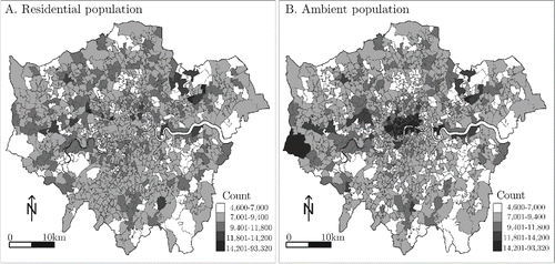
The residential and ambient populations were clustered identically in the southern, eastern, and northern areas, but the ambient population was denser in the central and western areas (). Also profound is the upper extremity of the range depicting the ambient population. Areas included up to 93,320 individuals after accounting for the commuting activity, whereas the highest count of the residential population was only 14,720.
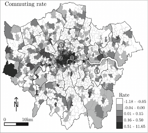
The distributional difference implies that commuting patterns exert uneven effects on the area-based population distribution. presents the commuting rate as upward or downward shifts in the residential population. Two areas had the most substantial upward shifts: The residential population of Hillingdon, in the west of the study area, rose to 10 percent after accounting for commuters, and the City of London and its neighboring areas in the center experienced as much as a 12 percent increase. Target estimates employing the residential population and those employing the ambient population would not be consistent for these areas. Similarly, areas near the periphery of the city center experienced reductions in counts due to commuting, and crime estimates employing the residential population data would not be consistent with ambient population estimates.
Figure 2. Commuter-induced changes in the residential population of Greater London (the classes are based on natural breaks in the data, and the thicker boundaries demarcate the authority districts). The areas marked 1, 2, 3, and 4 denote the City of London, Westminster, Camden, and Greenwich, respectively.
We placed violence counts on the numerator as an example for comparing the crime rankings for authority districts of Greater London (). Crimes in one group were weighted using residential population counts (R), and those in another group have ambient population counts (A) on the denominator. Results show a significant difference in the rankings, particularly on the left side of the scale. The City of London, Westminster, and Camden (marked in as 1, 2, and 3, respectively) were ranked the most violent in the first group, but the same areas took intermediate positions in the group employing the ambient population data. These areas experienced substantial inbound commuting. For example, commuters caused the residential population of Westminster and the City of London to rise by 93 percent. Conversely, Greenwich (marked as 4 in ) seemed moderately safe (rank 10) when the residential population was used and quite unsafe (rank 5) when the ambient population determined the rankings instead. One notices that this area has a greater residential than ambient population; that is, it experienced more outbound than inbound commuting. Because outward commuting reduced the number of residents, incorporating the absent residents into the crime statistics appears to have generated the inconsistency of the rankings. The areas situated at the bottom of the ranking experienced negligible commuting. Because their residential and ambient populations remained essentially the same, crime rankings remained consistent irrespective of which population was employed on the denominator.
Figure 3. Rates and rankings of London's violent crimes per authority district, derived on the basis of the residential population and the commuter-harmonized ambient population.
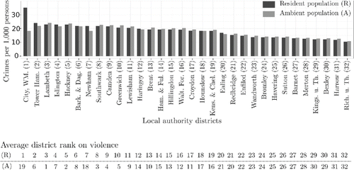
The difference in crime rankings was more profound for smaller census administrative areas. For example, the violence ranking for Tower Hamlets that employed the residential population was higher than the ranking based on the ambient population by 860 levels, and for the City of London it was higher by 836 levels. One of the City's administrative areas registered a commuting rate of 11,651. In other words, the residential population increased by 1,165 percent after accounting for commuting. At the bottom of the ranking scale, the ambient population of Lambeth included 17 percent fewer individuals than the residential population, and the residential violence ranking for this area was registered 130 levels higher than the ranking that employed ambient population data. Such observations demonstrate that the manner in which areas are characterized as being risky depends heavily on the population distribution that is applied to the crime outcomes.
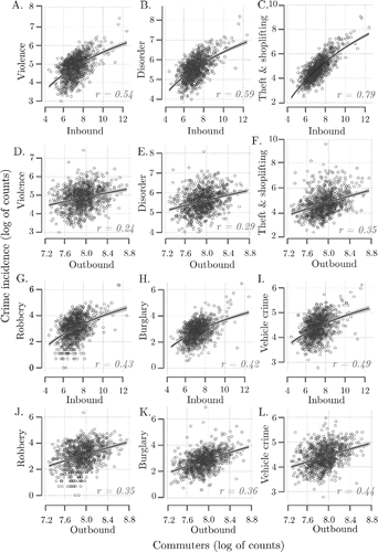
The underlying pattern of inbound commuting was greatly imbalanced (minimum = 94 persons, maximum = 242,796 persons, SD = 10,306 persons), and most of the crimes were positively correlated with inbound commuting (). Theft and shoplifting incidents were the most significantly correlated with inbound commuting (Pearson's r = 0.794, p < 0.001), followed by violence and disorder. Vehicle crime was affected only moderately by the effects of incomers. Such observations are consistent with the previous expectation that inbound commuters tend to cause or become targets of violence, disorder, and vehicle crimes. Although burglary was also positively correlated with inbound commuting (), this observation was unexpected given previous observations (e.g., Stults and Hasbrouck Citation2015). Consistent with the expectation, though, burglary was also positively correlated with outbound commuting (). With a relatively high coefficient (r = 0.36, p < 0.001), burglary was in fact the crime the second most closely associated with outbound commuting, after vehicle crime (r = 0.44, p < 0.001). Overall, the association between outbound commuting and other crimes was almost negligible. Outbound commuters appeared to have little influence on the criminality level of an area.
Figure 4. Correlates of commuting patterns and crime in administrative areas of Greater London. All Pearson correlations (r) are significant at the p = 0.01 level. Regression lines represent generalized additive smoothing functions and the 95 percent confidence intervals.
Regression Models
The close association of commuting patterns and crime prevalence made it necessary to assess the comparative utility of the residential population data and the ambient population data for crime estimation. presents a comparison of the NBMFootnote3 estimates obtained using the two populations as alternative offsets for different crimes. All of the models were adjusted for the predictorsFootnote4 listed in . Nagelkerke's R2 indicated better model fits with the ambient population offset than with the residential population one. Furthermore, Akaike's information criterion (AIC) scores were lower and likelihood ratio test statistics were significantly in favor of models based on the ambient population data.
Table 2. Model diagnostics of the negative binomial models using the residential and the ambient populations as offset
presents the results of the spatially filtered NBMs for six crimes. Estimates of the dispersion parameter, theta, show that significant adjustments for overdispersion were made to the Poisson count models. Moran's I statistics of the NBMs were insignificant (p > 0.050), signifying that the spatial filter effectively absorbed residual autocorrelation. It is also worth noting that a sensitivity analysis in which the spatial configuration of the filter was changed (e.g., from queen to rook) showed no particular differences in the model coefficients or the residual behavior.
Table 3. Results of spatially filtered negative binomial modelsFootnotea using the ambient population as offset
After adjusting for the variable COMMRATE, the model fit (i.e., R2, AIC) showed improvement for all crime estimates. Similarly, the likelihood ratio statistics were significant for all crimes except robbery. Overall, COMMRATE significantly affected all crimes, but it was positive for violence, disorder, and theft, whereas it was negative for robbery, burglary, and vehicle crime. Including the variable COMMRATE resulted in lower coefficient estimates for eighteen variables between models. Furthermore, two of these variables—NOCENTHEAT for violence and ADVEDUC for disorder—also became insignificant after this adjustment. In contrast, the inclusion of COMMRATE caused the once positive effect of DEPRHSE to become significant for theft and vehicle crimes. The model of burglary similarly exhibited an increase in the significance level of three predictors, namely, DEPRHSE, NOCENTHEAT, and ADVEDUC.
The variable 3+CARS exerted the least impact on crimes. Only two crimes were affected by this variable, albeit moderately (p < 0.050). Robbery was negatively influenced by 3+CARS, whereas the effect was positive for burglary. Similarly, HOMEOWN did not significantly affect four categories of crime, but its effect on violence and disorder was negative and highly significant (p < 0.001). Examining the local effects (not shown) revealed that HOMEOWN had a greater impact in the residential areas where inbound commuting is low. Finally, three variables—namely, DEPRHSE, NOCENTHEAT, and YMALES—were consistently associated with a higher crime risk. The last-mentioned variable, however, was not significant in its impact on burglary.
Discussion
Although the use of human mobility patterns for estimating risk is not new, given that the insufficiency of the residential population data is well known (see, e.g., Andresen and Jenion Citation2010; Andresen Citation2011; Stults and Hasbrouck Citation2015), previous research solutions have not used an established framework for defining the ambient population. Thus, inconsistencies in scale and data formation characterize existent strategies. Implementations of the ambient population have also focused on large areas, such as cities in which important human interactions remain veiled (Weisburd, Groff, and Yang Citation2012). This article proposes a new alternative way to represent targets in a more realistic manner, particularly when the crime data are not sufficiently detailed to differentiate between the daytime and the nighttime offending. In its construction of the ambient population, the study accounted for the day-to-day commuting of individuals across small areas. The results of this research have uncovered several important findings.
First, on the small spatial scale, the crime risk is highly influenced by mobility patterns. After computing crime rates using residential population data and comparing these rates with those that employed the ambient population data incorporating human mobility, neighborhood rankings of criminality differed profoundly between the two strategies. Additionally, in comparison with established factors underlying the crime risk, such as deprivation, this study has shown that the commuting rate is a far more important factor in explaining levels of crime risk. This evidence appears to be in agreement with Andresen's (Citation2011) suggestion that crime variations are largely influenced by the mobility of individuals. Indeed, the theory of routine activity (Cohen and Felson Citation1979) and other previous research (e.g., Ceccato and Uittenbogaard Citation2014; Felson and Boivin Citation2015) support the notion that crime risk increases due to the interaction of individuals in transit. This contributes important information for policymakers, namely, that security intervention strategies should be focused on places where there is a high level of commuting activity. Increased human interaction increases offending opportunities during inbound and outbound travel, and the resultant population changes alter the composition of offenders, victims, and safety guardians within areas. Thus, contextual influences on an area's risk can be incorrectly assessed if commuting patterns are overlooked.
Second, the relationship between human mobility and crime appears to be disproportionate, depending on the type of observed crime. For example, the commuting rate was positively linked with crimes that are purported to occur randomly (e.g., violence, disorder, theft) and negatively with purposive crimes, such as burglary and vehicle crimes. These broad patterns can be interpreted from the theoretical standpoints of routine activity and rational choice theories (Clarke and Felson Citation1993). It can be surmised that mobility facilitates both random and purposive behaviors, given the appropriate motivation and the general lifestyle of individuals. Nevertheless, the robbery estimates were largely unaffected by model adjustments for mobility. Including the commuting rate had the least impact on robbery, and the robbery model remained unchanged after substituting the residential population with the ambient one. This observation is supported by the goodness-of-fit tests in .
Third, inconsistent results emerge when studies fail to incorporate mobility information into the crime estimation or when such information is aggregated to large areas. For example, Ward et al. (2014) linked residential population data with burglary data and discovered that the crime–population relationship is positive. In contrast, Stults and Hasbrouck (Citation2015) found that burglary increased when the population shifted downward due to commuting, whereas less burglary occurred in the areas experiencing population shifts upward. It is the latter observation that coincides with our own. Stults and Hasbrouck (Citation2015), however, also observed an increased risk for vehicle crime due to increased commuting, which is contrary to what we observed. There are two possible reasons for this inconsistency. First, Stults and Hasbrouck estimated the crime outcomes as rates calculated from the residential population. Using the ambient population offset for this study might have increased the representativeness of crime targets, thus properly accounting for the guardianship against risk. Second, because Stults and Hasbrouck (Citation2015) observed crimes over cities, it is possible that the large size of areas obscured important crime influences.
Also in discord with previous findings (e.g., Farrell Citation2013; Sutherland, Brunton-Smith, and Jackson Citation2013) is that advanced education and increased car ownership, both of which are popularly linked with crime reduction, were correlated with high risk for certain crimes. We propose that educated citizens, who constitute a large proportion of the working population, represent convenient targets, as advanced education is depicted in census data that were provided for the workplace. Perhaps not surprisingly, working individuals are usually more at risk than their unemployed counterparts, and they are also more likely to interact while commuting. With regard to the positive relationship that was found between car ownership and burglary, the indication of affluence might have served to promote rather than hinder burglary. Because owners of multiple cars tend to leave their other cars behind, the presence of many cars in these areas might have attracted the inbound burglars. Thus, overlooking the crucial information that mobility patterns provide might explain why previous studies have obtained inconsistent results (Kwan Citation2012).
Fourth, our findings have shed light on the relative reliability of spatial crime statistics (e.g., Andresen Citation2011; Spielman and Singleton Citation2015). Profound differences appeared between models after adjusting for the commuting activity. On the one hand, the influence of certain variables increased: Deprivation and higher education became significant for burglary, and deprivation also became significant for vehicle theft. On the other hand, other effects (e.g., lack of central heating for violence, advanced education for disorder) became less significant. It appears that the commuting rate had an impact on the significance of conventional crime-influencing socioeconomic variables. This reduction in robustness for conventional variables after modeling mobility effects was also noted by Stults and Hasbrouck (Citation2015).
Overall, the ambient population was found to be an efficient proxy for crime and the local census variables, consistent with other research (e.g., Andresen and Jenion Citation2008; Malleson and Andresen Citation2015). Perhaps due to the contextual suitability, offsetting the crimes using the ambient population variable helped to partially absorb the residual spatial autocorrelation patterns. ESF further allowed misspecifications that arise from spatially autocorrelated residuals to be completely eradicated from the models.
Conclusion
As has been discussed in this article, residential population data are often used to derive crime estimates, but these data are insufficient because a significant amount of human interaction occurs outside delineated census areas. Incorporating the commuting patterns of individuals to model this interaction among individuals and the resultant opportunities for crime represents an important solution and a significant step forward in reliable risk estimation. It is expected that the simplicity of the strategy proposed for deriving the ambient population over small areas will encourage its widespread use in criminology.
Notwithstanding the promising contributions of this study, certain challenges and limitations will need to be addressed in future research. First, the census-based commuting patterns register as complete and accurate accounts of the work locations, but they do not represent all human activity patterns (Kwan Citation2012). Individuals also travel to places for leisure and tourism purposes, for example. As such, even though the commuting data employed here define a great part of human interaction and the everyday population changes, the missing link to other destinations can importantly complement the proposed ambient population data to mitigate the problem of representing the crime targets. Second, as with all studies dealing with a spatially delimitated area, the results might be affected by edge effects (Chainey and Ratcliffe Citation2013). This is because the data do not represent the commuting residents outbound from or inbound to London. The limitation might not critically affect the result here, because commuting was the most intense toward the center of London and we can reasonably assume that edge effects are negligible. Nevertheless, the missing information is equally relevant for estimating crime risk. Third, the modifiable areal unit problem (Openshaw Citation1984; Vogel Citation2016) might have artificially influenced the results. Because census blocks are designed for enumeration purposes, their delineations are theoretically unrealistic for characterizing the accumulation of risk. Finally, our approach only serves as an alternative where the daytime and nighttime crimes cannot be modeled separately. Felson and Poulsen (Citation2003) proposed that crimes aggregate differently by time of the day and, where available, the time stamps of crimes can provide more useful insights.
To conclude, this research has demonstrated that a strong relationship exists between human mobility patterns and the amount of small-area crime. Additionally, as inbound commuting increases in an area, the level of risk increases for random crimes, such as theft and violence. Therefore, there is a potential benefit in conceptually and empirically integrating crime research with research that examines the impact of human mobility on an area's risk. It also appears to be necessary to assess different ways of increasing the representativeness of crime targets within small-scale areas, instead of relying on the residential population data. Analytical models can incorporate information about mobility, interaction, and contextual aspects that characterize the daily activity of individuals (Kwan Citation2012). Another promising direction that has been advanced in the literature (e.g., Schubert Citation2009; Lemieux and Felson Citation2012; Mburu and Helbich Citation2016) is to link crime with contextual spatiotemporal influences.
Acknowledgments
The authors thank Professor Mei-Po Kwan for efficiently handling the blind review process for this article. We are also grateful for the valuable comments and suggestions from the anonymous reviewers. The first author thanks Professor Alexander Zipf (Heidelberg University, Germany) for his support during the writing of this article.
Funding
The first author thanks the German Academic Exchange Service (DAAD) for funding this research.
Additional information
Notes on contributors
Lucy W. Mburu
LUCY W. MBURU is a doctoral researcher with the GIScience Research Group, Institute of Geography, Heidelberg University, 69120 Heidelberg, Germany. E-mail: [email protected]. She is also a lecturer at the KCA University, Nairobi, Kenya. Her interests are in geospatial analysis and modeling.
Marco Helbich
MARCO HELBICH is an Assistant Professor in the Department of Human Geography and Planning at the Utrecht University, 3584 CS, The Netherlands. E-mail: [email protected]. His interests lie in urban geography and GIScience. In particular, he combines computational models and GIS-based approaches to investigate research challenges in real estate, crime, and health, among others.
Notes
1. The ambient population was adjusted to account for human mobility across observation areas when depicting the population at risk.
2. Spatial dependency refers to locational and attributional similarity. Positive spatial dependence, in which similar values are located close by across space, is the most prevalent type of dependence in empirical crime studies (Townsley Citation2009).
3. Lagrange multiplier tests (Hilbe Citation2014) were highly significant, indicating that the Poisson model was statistically insufficient for modeling the overdispersed crime data.
4. Condition indexes (Belsley, Kuh, and Welsch Citation2005) were used to test for multicollinearity in the predictors but no problems were found.
References
- Andresen, M. A. 2011. The ambient population and crime analysis. The Professional Geographer 63 (2): 193–212.
- Andresen, M. A., and G. W. Jenion. 2008. Crime prevention and the science of where people are. Criminal Justice Policy Review 19 (2): 164–80.
- ———. 2010. Ambient populations and the calculation of crime rates and risk. Security Journal 23 (2): 114–33.
- Andresen, M. A., G. W. Jenion, and A. A. Reid. 2012. An evaluation of ambient population estimates for use in crime analysis. Crime Mapping: A Journal of Research and Practice 4 (1): 7–30.
- Belsley, D. A., E. Kuh, and R. E. Welsch. 2005. Regression diagnostics: Identifying influential data and sources of collinearity. Hoboken, NJ: Wiley.
- Bernasco, W., and H. Elffers. 2010. Statistical analysis of spatial crime data. In Handbook of quantitative criminology, ed. A. R. Piquero and D. Weisburd, 699–724. New York: Springer.
- Bhat, C. R., J. Y. Guo, S. Srinivasan, and A. Sivakumar. 2004. A comprehensive econometric microsimulator for daily activity-travel patterns. Transportation Research Record 1894:57–66.
- Blyton, P. 2014. Changes in working time (Routledge Revivals): An international review. London and New York: Routledge.
- Boggs, S. L. 1965. Urban crime patterns. American Sociological Review 30:899–908.
- Boivin, R. 2013. On the use of crime rates. Canadian Journal of Criminology and Criminal Justice 55 (2): 263–77.
- Brantingham, P. J., and P. L. Brantingham, eds. 1981. Environmental criminology. Beverly Hills, CA: Sage.
- ———. 1984. Patterns in crime. New York: Macmillan.
- Cameron, A. C., and P. K. Trivedi. 1990. Regression-based tests for overdispersion in the Poisson model. Journal of Econometrics 46 (3): 347–64.
- Carter, R. L., and K. Q. Hill. 2014. The criminal's image of the city: Pergamon policy studies on crime and justice. Amsterdam: Elsevier.
- Ceccato, V. 2015. The geographic, socioeconomic, and cultural determinants of violence. In Oxford textbook of violence prevention: Epidemiology, evidence, and policy, ed. P. D. Donnelly and C. L. Ward, 77–86. New York: Oxford University Press.
- Ceccato, V., and A. C. Uittenbogaard. 2014. Space–time dynamics of crime in transport nodes. Annals of the Association of American Geographers 104 (1): 131–50.
- Chainey, S., and J. Ratcliffe. 2013. GIS and crime mapping. Hoboken, NJ: Wiley.
- Chun, Y. 2014. Analyzing space–time filtering using eigenvector spatial filtering: An application to vehicle burglary. Geographical Analysis 46 (2): 165–84.
- Chun, Y., and D. A. Griffith. 2013. Spatial statistics and geostatistics: Theory and applications for geographic information science and technology. Thousand Oaks, CA: Sage.
- Clarke, R. V. G., and M. Felson, eds. 1993. Routine activity and rational choice. New Brunswick, NJ: Transaction.
- Cliff, A. D., and J. K. Ord. 1981. Spatial processes: Models and applications. London: Pion.
- Cohen, L. E., and M. Felson. 1979. Social change and crime rate trends: A routine activity approach. American Sociological Review 44 (4): 588–608.
- Cohen, L. E., R. L. Kaufman, and M. R. Gottfredson. 1985. Risk-based crime statistics: A forecasting comparison for burglary and auto theft. Journal of Criminal Justice 13 (5): 445–57.
- Davenport, J. 2015. Crime on the rise in almost half of all boroughs in London. Evening Standard 27 March 2015. http://www.standard.co.uk/news/london/crime-on-the-rise-in-almost-half-of-all-boroughs-in-london-10137885.html (last accessed 15 January 2016).
- DeLisi, M. 2015. 4 age–crime curve and criminal career patterns. In The development of criminal and antisocial behavior, ed. J. Morizot and L. Kazemian, 51–63. Cham, Switzerland: Springer International.
- D'Orsogna, M. R., and M. Perc. 2015. Statistical physics of crime: A review. Physics of Life Reviews 12:1–21.
- Farley, J. E., and M. Hansel. 1981. The ecological context of urban crime: A further exploration. Urban Affairs Review 17 (1): 37–54.
- Farrell, G. 2013. Five tests for a theory of the crime drop. Crime Science 2 (1): 1–8.
- Felson, M., and R. Boivin. 2015. Daily crime flows within a city. Crime Science 4 (1): 1–10.
- Felson, M., and E. Poulsen. 2003. Simple indicators of crime by time of day. International Journal of Forecasting 19 (4): 595–601.
- Getis, A. 2009. Spatial weights matrices. Geographical Analysis 41 (4): 404–10.
- Griffith, D. A. 2000. Eigenfunction properties and approximations of selected incidence matrices employed in spatial analyses. Linear Algebra and Its Applications 321 (1): 95–112.
- ———. 2003. Spatial autocorrelation and spatial filtering: Gaining understanding through theory and scientific visualization. New York: Springer.
- ———. 2012. Space, time, and space–time eigenvector filter specifications that account for autocorrelation. Estadística Española 54 (177): 7–34.
- Griffith, D. A., and R. Haining. 2006. Beyond mule kicks: The Poisson distribution in geographical analysis. Geographical Analysis 38 (2): 123–39.
- Grover, C. 2013. Crime and inequality. London and New York: Routledge.
- He, L., A. Páez, D. Liu, and S. Jiang. 2015. Temporal stability of model parameters in crime rate analysis: An empirical examination. Applied Geography 58:141–52.
- Helbich, M., V. Blüml, M. Leitner, and N. D. Kapusta. 2013. Does altitude moderate the impact of lithium on suicide? A spatial analysis of Austria. Geospatial Health 7 (2): 209–18.
- Helbich, M., and J. Jokar Arsanjani. 2015. Spatial eigenvector filtering for spatiotemporal crime mapping and spatial crime analysis. Cartography and Geographic Information Science 42 (2): 134–48.
- Helbich, M., and M. Leitner. 2009. Spatial analysis of the urban-to-rural migration determinants in the Viennese metropolitan area: A transition from suburbia to postsuburbia? Applied Spatial Analysis and Policy 2 (3): 237–60.
- Hilbe, J. M. 2014. Modeling count data. New York: Cambridge University Press.
- Kwan, M. P. 2012. The uncertain geographic context problem. Annals of the Association of American Geographers 102 (5): 958–68.
- Le Blanc, M., and M. Frechette. 2013. Male criminal activity from childhood through youth: Multilevel and developmental perspectives. Heidelberg, Germany: Springer Science and Business.
- Leitner, M., and M. Helbich. 2011. The impact of hurricanes on crime: A spatio-temporal analysis in the city of Houston, Texas. Cartography and Geographic Information Science 38 (2): 213–21.
- Lemieux, A. M., and M. Felson. 2012. Risk of violent crime victimization during major daily activities. Violence and Victims 27 (5): 635–55.
- Liao, F. H., and Y. D. Wei. 2015. Space, scale, and regional inequality in provincial China: A spatial filtering approach. Applied Geography 61:94–104.
- Malleson, N., and M. A. Andresen. 2015. Spatio-temporal crime hotspots and the ambient population. Crime Science 4 (1): 1–8.
- Malleson, N., A. Heppenstall, and L. See. 2010. Crime reduction through simulation: An agent-based model of burglary. Computers, Environment and Urban Systems 34 (3): 236–50.
- Mburu, L., and M. Helbich. 2015. Evaluating the accuracy and effectiveness of criminal geographic profiling methods: The case of Dandora, Kenya. The Professional Geographer 67 (1): 110–20.
- ———. 2016. Communities as neighborhood guardians: A spatio-temporal analysis of community policing in Nairobi's suburbs. Applied Spatial Analysis and Policy. doi: 10.1007/s12061-015-9178-7.
- Office for National Statistics. 2011. Where do we commute to? Commuting patterns in the United Kingdom, 2011 Census. http://www.neighbourhood.statistics.gov.uk (last accessed 15 January 2016).
- ———. 2014. Regional and local statistics. www.ons.gov.uk/ons/regional-statistics/index.html (last accessed 15 January 2016).
- Openshaw, S. 1984. The modifiable areal unit problem. Norwich, UK: Geo Books.
- Osgood, D. W. 2000. Poisson-based regression analysis of aggregate crime rates. Journal of Quantitative Criminology 16 (1): 21–43.
- Sampson, R. J., S. W. Raudenbush, and F. Earls. 1997. Neighborhoods and violent crime: A multilevel study of collective efficacy. Science 277 (5328): 918–24.
- Schubert, J. L. 2009. Incorporating time and daily activities into an analysis of urban violent crime. PhD dissertation, The University of Texas at Dallas, Dallas, TX. http://gradworks.umi.com/33/75/3375964.html (last accessed 15 January 2016).
- Spielman, S. E., and A. Singleton. 2015. Studying neighborhoods using uncertain data from the American Community Survey: A contextual approach. Annals of the Association of American Geographers 105 (5): 1003–25.
- Stenson, K. 2013. Community safety in Middle England: The local politics of crime control. In Crime control and community: The new politics of public safety, ed. G. Hughes and A. Adams, 109–15. London and New York: Routledge.
- Stults, B. J., and M. Hasbrouck. 2015. The effect of commuting on city-level crime rates. Journal of Quantitative Criminology 31 (2): 331–50.
- Sutherland, A., I. Brunton-Smith, and J. Jackson. 2013. Collective efficacy, deprivation and violence in London. British Journal of Criminology 53 (6): 1050–74.
- Thayn, J. B., and J. M. Simanis. 2013. Accounting for spatial autocorrelation in linear regression models using spatial filtering with eigenvectors. Annals of the Association of American Geographers 103 (1): 47–66.
- Tita, G. E., and S. M. Radil. 2010. Spatial regression models in criminology: Modeling social processes in the spatial weights matrix. In Handbook of quantitative criminology, ed. A. R. Piquero and D. Weisburd, 101–21. New York: Springer.
- Townsley, M. 2009. Spatial autocorrelation and impacts on criminology. Geographical Analysis 41 (4): 452–61.
- Vandeviver, C., S. Van Daele, and T. Vander Beken. 2014. What makes long crime trips worth undertaking? Balancing costs and benefits in burglars' journey to crime. British Journal of Criminology. doi: 10.1093/bjc/azu078
- Vogel, M. 2016. The modifiable areal unit problem in person–context research. Journal of Research in Crime and Delinquency 53 (1): 112–35.
- Ward, J. T., M. R. Nobles, T. J. Youstin, and C. L. Cook. 2014. Placing the neighborhood accessibility–burglary link in social-structural context. Crime and Delinquency 60 (5): 739–63.
- Weisburd, D. L., E. R. Groff, and S. M. Yang. 2012. The criminology of place: Street segments and our understanding of the crime problem. London: Oxford University Press.
- Xu, C., D. W. Wong, and C. Yang. 2013. Evaluating the “geographical awareness” of individuals: An exploratory analysis of Twitter data. Cartography and Geographic Information Science 40 (2): 103–15.
- Zhang, H., and E. S. McCord. 2014. A spatial analysis of the impact of housing foreclosures on residential burglary. Applied Geography 54:27–34.