
Abstract
Many existing accessibility studies ignore human mobility due to the lack of large-scale human mobility data. This study investigates the impacts of human mobility on accessibility using massive mobile phone tracking data collected in Shenzhen, China. In this study, human mobility information is extracted from mobile phone tracking data using a time-geographic approach. The accessibility of each phone user is evaluated using fine spatial resolution across the entire city. The impacts of human mobility on accessibility are quantified by using relative accessibility ratios between phone users and a virtual stationary user in the same residential location. Results of this study enrich understandings of how land use influences relationships between human mobility and accessibility. For resource-poor regions with sparse service facilities, human mobility can greatly enhance individual accessibility. In contrast, for resource-rich regions with dense service facilities, human mobility can even reduce individual accessibility. Overall, human mobility can reduce spatial inequity of accessibility for people living in different regions of the city. The results of this study also have several important methodological implications for including human mobility and time dimension in accessibility evaluations.
诸多既有的可及性研究, 因为缺乏大尺度的人类移动数据而忽略了人类移动。本研究运用在中国深圳所搜集的大规模手机追踪数据, 探讨人类移动对于可及性的影响。在本研究中, 运用时间地理学取径, 从手机追踪数据取得人类移动信息。每位手机使用者的可及性, 通过整座城市的细微空间解析度进行评估。人类移动对于可及性的影响, 运用同一住宅区位中的手机使用者和虚拟的静止使用者之间的相对可及性比率进行量化。此一研究成果, 丰富了我们对于土地使用如何影响人类移动和可及性之间的关系之理解。在资源贫嵴且服务设施缺乏的区域, 人类移动能够大幅增进个人的可及性。反之, 在资源丰沛且服务设施密集的区域, 人类移动甚至会降低个人的可及性。总体而言, 人类移动能够减少生活在城市不同区域中的人们的可及性之空间不均。本研究之成果, 对于包括可及性评估中的人类移动和时间面向, 同时具有若干重要的方法论意涵。
Gran parte de los estudios existentes sobre accesibilidad ignoran la movilidad humana debido a la falta de datos sobre este fenómeno a gran escala. Este estudio investiga los impactos de la movilidad humana sobre la accesibilidad con el uso de gran un volumen de datos de rastreo de teléfonos móviles, recogidos en Shenzhen, China. En este estudio, la información sobre la movilidad humana es extraída de datos del rastreo de teléfonos móviles, a través del uso de un enfoque geográfico del tiempo. La accesibilidad de cada usuario de teléfono es evaluada con resolución espacial fina aplicada a toda la ciudad. Los impactos de la movilidad humana sobre la accesibilidad son cuantificados a partir de ratios de accesibilidad relativa entre los usuarios del teléfono y un usuario virtual estacionario en la misma localización residencial. Los resultados de este estudio enriquecen el entendimiento de cómo influye el uso del suelo las relaciones entre movilidad humana y accesibilidad. Para las regiones pobres en recursos con facilidades de servicios de baja densidad, la movilidad humana puede fortalecer fuertemente la accesibilidad individual. Por contraste, para las regiones ricas en recursos con facilidades de servicios muy densas, la movilidad humana puede incluso reducir la accesibilidad individual. En general, la movilidad humana puede reducir la injusticia espacial de accesibilidad para gente que reside en diferentes regiones de la ciudad. Los resultados de este estudio tienen también varias implicaciones metodológicas importantes para incluir la movilidad humana y la dimensión tiempo en las evaluaciones de accesibilidad.
The paramount goal of urban planning is to provide sufficient opportunities for citizens to access urban services, such as jobs, food, shopping, and recreational services. High-level accessibility to urban services is crucial for urban life viability. Equitable access to urban services is also strongly related to social exclusion issues, with the aim to avoid barriers to participating in normal activities (Stanley et al. Citation2011; van Wee and Geurs Citation2011). Evaluating accessibility of urban services over different regions and social groups has been a major issue in the geography and urban planning literature (Kwan and Weber Citation2003; Geurs and van Wee Citation2004; Langford and Higgs Citation2010; Páez et al. Citation2010; B. Y. Chen et al. Citation2013; Farber et al. Citation2013; Horner and Wood Citation2014; Niedzielski and Boschmann Citation2014).
Accessibility of urban services depends on three components: urban service spatial distribution (i.e., land use), transportation network efficiency, and individual socioeconomic characteristics (Kwan Citation1998; Geurs and van Wee Citation2004; Niedzielski and Boschmann Citation2014). Traditionally, accessibility has been evaluated by place-based accessibility measures, which are conceptualized mainly in terms of locational proximity to individuals' residential areas. Place-based accessibility measures, such as cumulative opportunity and gravity-based measures, are valuable and require only a few aggregated data (Geurs and van Wee Citation2004; B. Y. Chen, Yuan, et al. Citation2017; Yang et al. Citation2017). These place-based measures, however, consider only land use and transportation components and have been criticized for ignoring distinct individual human mobility patterns of different socioeconomic groups. Obviously, people move around a range of places in the course of their daily lives, and residential areas might not adequately represent a real individual's activity spaces (Kwan Citation2012; Jones and Pebley Citation2014). Thus, ignoring human mobility might obfuscate what people actually experience in their everyday lives and might introduce significant bias to accessibility studies (Kwan Citation2012, Citation2013).
With the availability of activity diary data since the 1990s, considerable research efforts have been made to develop individual-based (or space–time) accessibility measures by explicitly considering individual mobility of different socioeconomic groups (Kwan Citation1999; Miller Citation1999; Kim and Kwan Citation2003; Kwan and Weber Citation2003; Neutens, Schwanen, and Witlox Citation2011). An activity diary data set records detailed information of every activity conducted by sample individuals within a particular time period, such as activity location, type, beginning and ending times, and so on (J. Chen et al. Citation2011). With this activity diary data set, human mobility of sample individuals can be well quantified by using time-geographic approaches (Hägerstrand Citation1970), in terms of daily potential path area (DPPA) or daily space–time prism (DSTP). The DPPA represents the individual's potential activity space in two-dimensional (2D) geographical space, whereas the DSTP extends this by capturing the individual's time available for activity participation. The number of opportunities within the DPPA (called CUM measure) and the cumulative activity durations at opportunities with the DSTP (called DUR measure) are two commonly used individual-based measures. These individual-based measures have been widely recognized as powerful indicators to evaluate accessibility of individuals in different socioeconomic groups and geographical regions (Kwan and Weber Citation2003; Miller Citation2007). Only a few studies, however, have compared results obtained from DUR and CUM measures to evaluate the impacts of including the time dimension in accessibility studies (Neutens et al. Citation2010; Kwan Citation2013).
Due to the key role of human mobility in accessibility evaluation, much attention in the literature has been given to evaluating human mobility impacts on accessibility. Many transport-related social exclusion studies have evaluated accessibility for disadvantaged people living in resource-poor regions with sparse service facilities, such as female (McCray and Brais Citation2007), disabled (Casas Citation2007), and low-income individuals (Rogalsky Citation2010; Stanley et al. Citation2011; Kamruzzaman and Hine Citation2012). Poor mobility, in terms of small DPPA, has been identified as a key factor making it difficult or impossible for disadvantaged people to access certain urban services outside their activity spaces. These transport-related social exclusion studies have provided significant evidence to support that provision of adequate mobility to disadvantaged people can significantly enlarge their DPPA and thereby improve their accessibility in terms of the CUM measure. Few studies, however, have investigated impacts of human mobility on accessibility in terms of the DUR measure by explicitly considering individual time available for activity participation. Most previous studies were restricted to a relatively small geographical area with few samples, due to the difficulty of collecting large-scale human mobility data through traditional activity diary surveys. Therefore, it remains unclear how human mobility affects accessibility for people living in different areas with distinct land use characteristics, including resource-poor and resource-rich regions.
Recent advances in information and communication technologies offer new sources of spatiotemporal big data for collecting human mobility information, such as social media data, taxi trajectories, smart card data, and so on (Miller Citation2005b; Li et al. Citation2013; Miller and Goodchild Citation2015; B. Y. Chen et al. Citation2016; Kwan Citation2016). Among various technologies, mobile phone tracking is a promising technique to collect human mobility information for large numbers of individuals over the entire region. The mobile phone tracking data sets are generated by the business operations of mobile telecommunication networks. The locations of phones in terms of connected cellular towers are automatically recorded without contacting the users being tracked. These data sets are a by-product generated for network management purposes and theoretically available at no cost for data analyses. In recent years, mobile phone tracking data have been widely used for human mobility studies (Gonzalez, Hidalgo, and Barabasi Citation2008; Ahas, Aasa, et al. Citation2010; Song et al. Citation2010; Ahas et al. Citation2015; Xu et al. Citation2015; Xu et al. Citation2016) and transportation applications (Caceres et al. Citation2012; Iqbal et al. Citation2014; Pei et al. Citation2014). Nevertheless, there has been little attention in the literature on using mobile phone tracking data for accessibility studies.
This study seeks to fill two gaps in human mobility and accessibility studies. It extends previous studies by investigating human mobility impacts on accessibility for the entire region of a megacity with diverse land use characteristics, providing new insights on how land use influences relationships between human mobility and accessibility. It also examines human mobility impacts on accessibility in terms of the DUR measure, to explicitly consider the critical time dimension with respect to individual time available for activity participation. To fulfill these research objectives, a large-scale mobile phone tracking data set is collected, including twenty-four-hour trajectories of more than 6 million phone users, across the entire region of Shenzhen, China. This collected data set offers an effective means to extract human mobility information, in terms of DPPA and DSTP, for a massive number of individuals across the whole study region. Individual accessibility to typical urban services for all collected phone users is evaluated using CUM and DUR measures at a fine resolution of cellular tower. To quantify human mobility impacts on accessibility, virtual users stationary within their residential area are constructed for each cellular tower as the reference user group. Relative accessibility ratios between actual and stationary virtual users at the same cellular tower are derived to derive human mobility impacts on accessibility in terms of both CUM and DUR measures. Results of this study will enrich our understanding of how land use influences relationships between human mobility and accessibility and also provide methodological implications for incorporating human mobility and time dimension into accessibility evaluations.
Traditional Place-Based Accessibility Measures
This section briefly introduces traditional place-based accessibility measures to provide necessary background. Accessibility has traditionally been evaluated by place-based accessibility measures, which ignore human mobility and only consider an individual's residential area as the relevant geographic context. For instance, the widely used cumulative opportunity measure (Breheny Citation1978; denoted by ) can be expressed as
(1)
(2) where
is the travel time between residential location x and facility f and
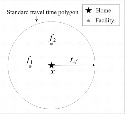
is a fixed cutoff distance parameter representing an individual's capability (or willingness) to travel for activity participations. An underlying assumption in this accessibility measure is that potential activity spaces of all people living in location x is the standard travel time polygon centered at their residential location (Sherman et al. Citation2005; see ). The accessibility of people living at location x is evaluated by the cumulative number of facilities within the potential activity space.
indicates that facility f is within the potential activity space. This cumulative opportunity measure is valuable and easily interpretable but often criticized for ignoring human mobility, hence oversimplifying individuals' potential activity spaces.
Figure 1. Standard travel time polygon concept.
As an extension, Delafontaine, Neutens, and Weghe (Citation2012) proposed a set of place-based space–time accessibility measures incorporating the time dimension from individual-based perspectives. In the proposed measures, a round trip from residential location x to facility f was considered to construct the space–time service area centered at the facility. The accessibility of people at location x was evaluated by the number of reachable facilities whose service area covers the location x. This formulation was equivalent to the assumption that all potential activity spaces of people living at location x were the space–time prism (denoted by ) with both origin and destination located at x. The space–time prism concept (Miller Citation2005a) is illustrated in in three-dimensional (3D) space and can be expressed as
(3) where r and s are origin and destination, respectively;
and
are departure time and preferred arrival time, respectively;
and
are travel time from origin r to facility f and travel time from facility f to destination s, respectively; and
is the minimum activity time required for activity participation. The height of the space–time prism at f represents the maximum activity duration,
. The effect of facility opening hours can also be represented by intersecting the activity duration with facility opening,
, and closing,
, times:
(4) where
and
are the earliest arrival and latest departure times, respectively, at facility f. Accessible facilities,
, can be determined according to constraint
.
Figure 2. Space–time prism concept.
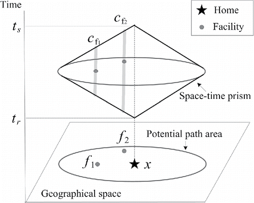
The projection of the space–time prism onto 2D geographical space is the potential path area (denoted by ). If the travel time budget
is set as
, then the potential path area is equivalent to the standard travel time polygon defined in . Using potential path area as an individual's potential activity space, the cumulative opportunity measure can be expressed as
(5)
(6) where
is a binary variable indicating whether facility f is within the potential activity space. Incorporating activity durations at accessible facilities, Delafontaine, Neutens, and Weghe (Citation2012) proposed an activity duration weighted accessibility measure,
:
(7)
These place-based space–time accessibility measures have made substantial improvements to the conventional cumulative opportunity measure by incorporating the time dimension. They consider residential location as a single reference location, however, and ignore other key places, such as workplaces and recreational locations. Furthermore, they do not allow for interpersonal heterogeneity in human mobility, assuming the same level of accessibility for all people at a residential location. In this study, we extend these place-based space–time accessibility measures to incorporate human mobility information derived from mobile phone tracking data.
Study Area and Data Collection
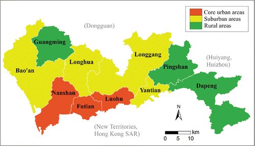
Shenzhen is a major economic center in south China. It is located within the Pearl River Delta, bordering Hong Kong to the south. During the past thirty years, Shenzhen has been considered one of the fastest growing cities in the world in terms of population growth and economic development. The city covers an area of approximately 1,996 km2 and had a total population of approximately 10.54 million in 2012, with a density of over 5,282 inhabitants/km2. Immigrant population accounts for more than 70 percent of the total city population. shows that Shenzhen city consists of ten administrative districts. Luohu, Futian, and Nanshan districts are core urban areas with highly developed economies, dense population, and service facilities. Bao'an, Longhua, Longgan, and Yantian districts are suburban areas, including some new towns and a concentration of electronics factories. The remaining districts (Guangming, Pingshan, and Dapeng) are rural areas with large hilly and agriculture lands and a few industrial parks. The unique socioeconomic and demographic status of Shenzhen makes it an interesting area for accessibility studies (Xu et al. Citation2015).
Figure 3. Administrative districts of Shenzhen city.
Three data sets were collected in the city of Shenzhen, including mobile phone tracking data, road network data, and facility data of urban services. The mobile phone tracking data set was collected on 23 March 2012 (Friday), consisting of 174.6 million positioning records of 6.21 million users (approximately 58.92 percent of the total population). In this data set, the location of a phone user , in terms of connected cellular tower, was tracked at the time instance when a call was placed or received or a short message was sent or received. If the users were not on a call, their locations were also tracked at regular or irregular time intervals for network operating purposes. The average sampling frequency of users' trajectories was one hour and users with missing data (i.e., fewer than twenty-four position records) were excluded in the data analysis. To protect user privacy, the data set had been anonymized by the mobile phone carrier before it was made available for this study. Actual phone numbers and other personal information were not included in the tracking data set.
This mobile phone tracking data set consists of 5,930 cellular towers in Shenzhen. Any mobile phone located inside the Thiessen polygon is closest to the corresponding cellular tower. Because the phone location was set as its connected cellular tower, polygon size has a significant impact on positioning accuracy of mobile phone locations. In this data set, Thiessen polygons varied from 0.001 km2 to 14.5 km2 and were smaller in core urban areas than rural areas. The average size of the Thiessen polygons was 0.33 km2, and over 93.74 percent of Thiessen polygons are less than 1 km2. The average positioning error of this mobile positioning was approximately 300 m in core urban areas and suburban areas and approximately 2 km in rural areas, which seems reasonable given the large study area of this case study.
The Shenzhen road network data set included the major roads in the city and consisted of 14,414 nodes and 16,723 links. The traffic conditions of the road network were estimated by a real-world floating car data set for the same day as the mobile phone tracking data set. The floating car data set included trajectories of 17,406 taxis in Shenzhen city. The Global Positioning System (GPS) sampling interval for each taxi is about thirty seconds. All taxi trajectories were matched onto the road network using the multicriteria dynamic programming map-matching algorithm proposed by B. Y. Chen et al. (Citation2014) and then separated into link segments to estimate the hourly travel times for all network links. These estimations of hourly traffic conditions were explicitly used for analyzing human mobility and individual accessibility.
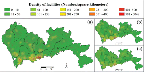
The facility data set consisted of three types of facilities in Shenzhen, including 6,899 foodservice facilities (mainly restaurants), 8,807 recreational facilities (including cinemas, bars, gymnasiums, cybercafes, etc.), and 3,705 shopping facilities (including shopping malls and grocery stores). shows that these facilities are not evenly distributed but rather are clustered in the three core urban areas, particularly in Luohu and Futian districts.
Figure 4. The spatial distributions of facilities: (A) foodservice facilities; (B) recreational facilities; (C) shopping facilities.
Method
In this study, four steps are designed to investigate human mobility impacts on accessibility using mobile phone tracking data. The first step is to estimate residential location of each phone user. Because residential locations of phone users are not explicitly provided in the mobile phone tracking data sets, they are estimated based on user trajectories. For each phone user, cellular towers between 22:00 and 06:00 are considered their candidate residential locations, based on the reasonable assumption that most people would stay at their home through overnight. Then, the user's residential location is determined if five hourly records (of eight possible) are at the same cellular tower over the eight-hour period. Because the location records of a phone user could jump among several adjacent cellular towers even though the user is stationary, a spatial tolerance can be adopted (i.e., 500 m used in this study). Previous studies (Ahas, Silm, et al. Citation2010; Xu et al. Citation2015) have shown that this method can identify residential locations for most phone users (i.e., over 99 percent of all users). In addition, no residential location might be identified in cellular towers in remote rural areas or in urban areas with very small sizes. To address this issue, cellular towers without data are merged with the nearest cellular tower that had valid data. Accordingly, the merged cellular towers are used as the basic analysis units, and further analyses are restricted to phone users with identified residential locations.
The second step is to estimate potential activity spaces of each phone user. In this study, the potential activity spaces of user are estimated using a time-geographic approach to construct a chain of space–time prisms along the user trajectory during time periods of interest, as
,…,
,…,
. The time budget for each space–time prism is the time duration between two corresponding sample points (i.e., one hour in this study). The parameter
can be used in the space–time prism construction to consider the minimum activity duration constraint. illustrates this concept using a typical user trajectory during three time periods (i.e., 07:00–09:00, 12:00–14:00, and 17:00–21:00) for a weekday. The users' working hours (i.e., 09:00–12:00 and 14:00–17:00) and sleeping hours (i.e., 21:00–07:00) for conducting nondiscretionary activities (i.e., working, sleeping, and in-home activities) are excluded in the analysis. During time periods of interest, each space–time prism delimits all possible unobserved space–time locations between two adjacent samples. The constructed space–time prisms can be superimposed to create a daily space–time prism (denoted by
). This
delimits all possible unobserved space–time locations for the user's movements or activity participations, constrained by the tracked locations along the user trajectory. Projection of such space–time prisms onto 2D geographical space forms a series of potential path areas,
,
,…,
, which can be aggregated to create a daily potential path area (denoted by
). These
and
can be regarded as 2D and 3D approaches for representing the phone user's mobility, respectively (Patterson and Farber Citation2015).
Figure 5. Potential activity spaces derived from mobile phone tracking data: (A) typical sampled user; (B) reference stationary user.
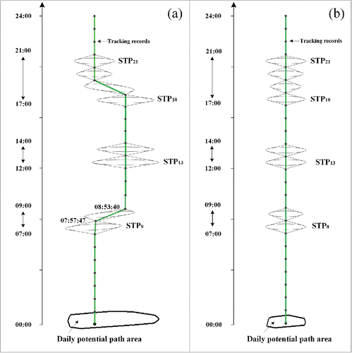
It should be noted that these and
concepts, to some extent, are different from the classical concepts based on activity diary data (Kwan Citation1998). As shown in , however, the constructed
can be regarded as a generalization of previous potential activity space concept shown in , which is the DSTP of a stationary user. Compared with the previous concept (see ), the constructed
and
(see ) can fully capture mobility of the phone user from multiple reference points in the course of their daily life, rather than a single residential location. In addition, the constructed
and
can capture different mobility patterns of people living within the same residential locations. Further, empirical studies have shown that the phone user's potential activity space can be well represented by standard travel time polygons centered at multiple reference points (i.e., top N locations, such as home, workplaces, schools, etc.; Zang and Bolot Citation2011; B. Y. Chen, Wang, et al. Citation2017). Typically, these top N locations could be recorded by sample points of user trajectories during three periods of interest (i.e., 07:00–09:00, 12:00–14:00, and 17:00–21:00). Therefore, we believe that
and
can be valuable proxies for phone users' potential activity spaces. Based on results of empirical studies (Zang and Bolot Citation2011; B. Y. Chen, Wang, et al. Citation2017),
minutes is set (i.e., to construct standard travel time polygons of twenty minutes around the top N locations).
Consequently, the mobility pattern for any user, , can be measured using the sizes of extracted 2D and 3D potential activity spaces; that is, DPPA size and DSTP volume. They are expressed, respectively, as cumulative lengths of accessible links (Kwan Citation1998) and cumulative activity durations on all accessible links (Neutens et al. Citation2008; H.-P. Chen et al. Citation2016). In addition to these 2D and 3D indicators, traveled distance along the user's trajectory during three time periods of interest is also calculated, as it is a commonly used one-dimensional (1D) indicator in the literature.
Following Kwan (Citation1998), different human mobility patterns of phone users using 1D, 2D, and 3D indicators are quantified using Spearman's rank correlation coefficients (Spearman Citation1904; B. Y. Chen et al. Citation2012). This correlation coefficient (denoted by p) quantifies the statistical dependence between rankings of two indicators. For example, the correlation coefficient between DPPA sizes and DSTP volumes can be expressed as(8) where
and
, respectively, are the rankings of DSTP volume and DPPA size for user
among all phone users, and m is the total number of phone users in the data set. Because only the rankings are used, this correlation coefficient can assess relationships between measures with different dimensions. The value of p is between –1 and 1, where
indicates a perfect negative correlation and
indicates a perfect positive correlation.
The third step is to evaluate accessibility for each phone user by using the user's estimated 2D and 3D potential activity spaces. In this study, two accessibility measures are proposed to evaluate the user's accessibility to urban services. The first proposed measure, denoted by , is the cumulative number of accessible facilities within the user's 2D potential activity space in terms of
,
(9)
(10) where
indicates that facility f is within the user's potential activity space
;
otherwise. The second measure, denoted by
, is the cumulative activity durations at facilities within the user's 3D potential activity space in terms of
,
(11) where
is the cumulative activity durations at f derived from all
of
. This
measure extends the
measure by incorporating time dimension (in terms of time available for activity participation) in the accessibility evaluation.
Following Neutens et al. (Citation2010), the Gini coefficient is adopted to evaluate spatial inequity of accessibility. The Gini coefficient, denoted by GC, can evaluate the inequality among accessibility values for different cellular towers. The Gini coefficient is expressed as the average absolute difference of all pairs of accessibility values divided by the average value:(12) where
is the accessibility value (e.g., mean
value) at cellular tower i and n is the total number of cellular towers in the study area. The GC value ranges from 0 (i.e., complete equality) to 1 (i.e., complete inequality). A larger GC value implies more unequal spatially distributed accessibility.
The final step is to investigate mobility impacts on accessibility of each phone user using the relative accessibility concept. In this study, a virtual user h who is stationary at home for the whole day is constructed for each residential location (i.e., cellular tower) as a reference user (see ). Note that the variation of space–time prism sizes in is due to the variation of traffic conditions in different times of the day. The two proposed accessibility measures are calculated for the reference stationary user h, denoted by and
, respectively. These
and
measures can be regarded as the previous place-based space–time accessibility measures defined in Equations Equation5
(5) through 7, which ignore human mobility.
A comparison of CUM accessibility measures between phone user and reference stationary user h provides the relative CUM accessibility measure:
(13)
This relative accessibility measure is interpreted as a proportion, the number of facilities available to user , with respect to the number of facilities available to reference user h at the same resident location. Similarly, a comparison of DUR accessibility measures between
and h provides the relative DUR accessibility measure
(14)
These and
indicators reflect the impacts of human mobility on the phone user's accessibility.
indicates that mobility enhances accessibility of user
, whereas
indicates that mobility reduces the user's accessibility. Human mobility impacts on accessibility spatial inequity, in terms of
or
, can be quantified through the differences of corresponding Gini coefficients between phone and reference stationary users.
Results
Human Mobility Patterns
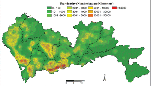
Reported first are the results of residential location estimation for all collected phone users. Residential locations of 6.16 million users (approximately 99.2 percent) were identified based on phone user trajectories. The identified residential locations were distributed over 5,858 cellular towers; the other seventy-two cellular towers without data were merged to their nearest cellular tower. shows the density of mobile phone users in terms of their identified residential locations. Phone users were concentrated in the three core urban areas, particularly the Luohu and Futian districts. Two suburban areas, Bao'an and Longhua, close to the core urban areas also showed relatively dense concentrations of phone users.
Figure 6. Spatial distribution of mobile phone users.
Human mobility patterns of all phone users were then investigated using 1D, 2D, and 3D indicators (i.e., traveled distance, DPPA size, and DSTP volume). and show extracted traveled distances for all phone users across the study area. Human movements in Shenzhen city were dominated by short distance travel, with average travel distance approximately 8.79 km. The coefficient of variation (CV; ratio of standard deviation to mean) showed significant interpersonal variation of user traveled distances. Larger CV implies larger interpersonal variation among phone users. People in suburban and rural areas tend to have higher inhomogeneity (i.e., larger CV).
Figure 7. Extracted human mobility patterns using 1D, 2D, and 3D indicators: (A) and (B) traveled distance; (C) and (D) daily potential path area; and (E) and (F) daily space–time prism. DPPA = daily potential path area; DSTP = daily space–time prism.
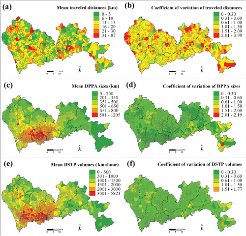
Spearman's rank correlation coefficients for the 1D, 2D, and 3D indicators are quantified and summarized in . A very weak positive correlation () was observed between traveled distance and DPPA size. This result was confirmed by their distinct mobility patterns (see and ). People in core urban areas with dense road networks have large mean DPPA sizes, whereas those in rural areas, despite long traveled distances, tend to have relatively small mean DPPA sizes. Such distinct patterns arise because individual DPPA depends not only on individual traveled distance but also on the area's built-up density (measured by road network density). This is consistent with previous studies that have shown that traveled distance is incapable of representing complete human mobility patterns and is not relevant to individual geographic context (Sherman et al. Citation2005; Kamruzzaman and Hine Citation2012; Patterson and Farber Citation2015). Such a result was also supported by the weak negative correlation (
) between traveled distance and DSTP volume indicators.
Table 1. Correlation coefficients and coefficient of variation for mobility indicators and accessibility measures
A modest positive correlation () was found between DSTP volume and DPPA size indicators. This positive correlation was consistent with the similar spatial patterns shown in and . A distinctive spatial disparity of DSTP volumes was observed, however, between people from different regions. As summarized in , the CV of DSTP volumes for all phone users was 0.64, approximately 30 percent larger than that of DPPA sizes (0.49). From this perspective, it might suggest that
, which considers individual time available for activity participation, can better articulate heterogeneity of human mobility across individuals than
.
Individual Accessibility Patterns
Individual accessibility ( and
) measures were calculated for all phone users across the whole study area using the extracted potential activity spaces (
and
).
and show accessibility to foodservice facilities based on the measure (i.e., cumulative number of foodservice facilities within the user's
). As illustrated in , mobile phone tracking data allow accessibility of a massive number of phone users to be generated at fine resolution across a large study area. People in various regions of the city have significantly different patterns of accessibility, in terms of the number of foodservice facilities available. People in resource-rich regions with dense service facilities (mainly in the core urban areas) tend to have a higher level of accessibility than those in the resource-poor regions with sparse service facilities (mainly in suburban and rural areas). It was found in that the
measure can well capture the interpersonal variation for phone users living in the same residential area. A significantly larger interpersonal variation of accessibility was found for phone users in suburban and rural areas than core urban areas.
Figure 8. Accessibility to food services based on and
measures.
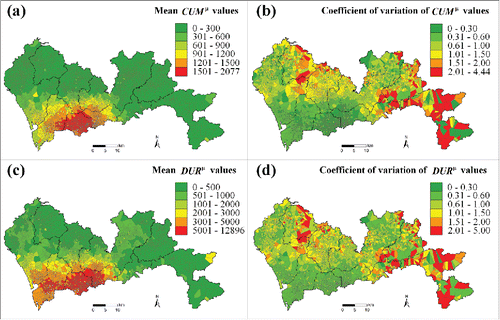
and illustrate the calculated individual accessibility to food service facilities using the measure. As illustrated, a similar spatial pattern of accessibility can clearly be observed between
and
measures. Compared to
defined in 2D activity space,
evaluates accessibility in terms of the cumulative activity durations at all accessible facilities within the user's 3D activity space (i.e.,
). A strong positive correlation (
) was found between
and
(see ). It also can be observed from the figures that the
measure produced more differentiated spatial patterns of accessibility than the
measure. The CV of
was 1.16, approximately 31.8 percent larger than that of the
measure (0.88). This result could suggest that inclusion of time available for activity participation is more suitable to capture individual accessibility spatial patterns across various regions.
The importance of incorporating time available for activity participation in the accessibility valuation was further investigated. shows the (yellow) and
(green) rankings for the largest 1,000 DPPA phone users. Both rankings of
and
are shown in using a logarithm scale. Among these phone users, 331, 666, and 3 of them were living in urban, suburban, and rural areas, respectively. As shown, users with large DPPA sizes tend to also have large
values. More than half (56.8 percent), including 92.7 percent of users in core urban areas, were ranked within the top 1,000 and almost all (95.9 percent) within the top
values. This suggests that large DPPA size implies high accessibility with respect to the
measure. This observation was supported by the strong positive correlation (
) between
and DPPA (see ) and is consistent with Kwan (Citation1998).
Figure 9. and
rankings for the largest 1,000 daily potential path area phone users. DPPA = daily potential path area.
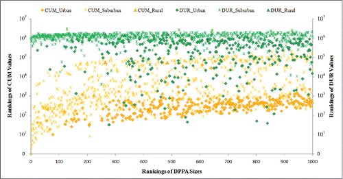
However, the situation is somewhat different for the measure, with only a modest correlation (
) between
and DPPA (see ). As shown in , very few phone users with large DPPA size (1.4 percent) were ranked within the top 1,000
values. The majority of users (87.6 percent), including 98.5 percent of users in suburban and rural areas, were ranked outside the top
values. Thus, it reveals that large DPPA size does not imply high accessibility with respect to the
measure. In fact, large DPPA size can also indicate significant time resource allocation for traveling, reducing the time resource for activity participation and hence reducing
accessibility. This suggests that time available for activity participation is a critical factor for accessibility evaluation, and ignoring this factor could lead to biased individual accessibility patterns.
Human Mobility Impacts on Accessibility
Human mobility affects accessibility with respect to both and
measures that were quantified using the relative accessibility measures; that is, the ratio of actual users against the stationary user in the same cellular tower,
and
, respectively. The DPPA and DSTP ratios are similarly defined.
and show the calculated DPPA sizes and values for stationary users in all cellular towers, respectively. and show the DPPA ratios and
values, respectively. It can be observed from that human mobility significantly enhances accessibility in terms of
measure for all phone users across the entire city, but the impacts are highly spatially uneven. As summarized in , human mobility has more positive impacts on people in rural areas (average
) and suburban areas (average
) than in core urban (average
) areas. This result is expected. As shown in , human mobility can significantly enlarge individuals' DPPA sizes, especially for people in those resource-poor regions. Such a result, that human mobility can significantly enhance
accessibility for disadvantaged individuals in resource-poor regions, is consistent with previous transport-related social exclusion studies (Casas Citation2007; Preston and Rajé Citation2007; Stanley et al. Citation2011; Kamruzzaman and Hine Citation2012).
Figure 10. Human mobility impacts on accessibility in terms of measure. DPPA = daily potential path area.
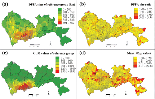
Table 2. Average relative accessibility ratios for different city regions and service types
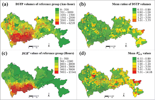
and show the calculated DSTP volumes and values for stationary users in all cellular towers, respectively. and show the DSTP ratios and
values, respectively. It can be seen from that human mobility impacts on
accessibility are spatially uneven and largely influenced by the richness of service facilities. For resource-rich regions with dense service facilities (including most core urban areas), mean
values were less than 0.8, suggesting that human mobility can significantly reduce
accessibility for people living in resource-rich regions. This seems reasonable and is confirmed by , which shows that human mobility reduced DSTP volumes for people living in resource-rich regions. The situation is significantly different, however, for people living in resource-poor regions with sparse facilities, largely suburban and rural areas. shows that average
ratios were larger than 1.2 for many cellular towers in rural areas and larger than 3.0 for several remote rural areas. It reveals that human mobility can greatly enhance
accessibility for people living in resource-poor regions. In contrast to resource-rich regions, although human mobility might also reduce individual DSTP volumes (), trips by people from resource-poor regions enable them to enjoy urban services provided by other regions of the city. Therefore, human mobility impacts on accessibility in terms of the
measure are spatially uneven. Human mobility can significantly enhance accessibility for people living in resource-poor regions, while reducing accessibility for people living in resource-rich regions.
Figure 11. Human mobility impacts on accessibility in terms of measure. DSTP = daily space–time prism.
Interestingly, this result that human mobility impacts on accessibility are either positive or negative contradicts the earlier outcome using the measure that human mobility impacts are positive for all regions. Although people living in resource-poor regions showed a significant positive impact of human mobility for both
and
measures, as shown in , the
measure tends to overestimate 30.8 percent (i.e., 1.53/1.17 – 1) of human mobility impact on accessibility. This contradiction shows that ignoring time available for activity durations could lead to bias or even erroneous conclusions of human mobility impacts on accessibility and also suggests that time available for activity durations should be explicitly incorporated in accessibility studies.
The Gini coefficient concept was also employed to quantify human mobility impacts on the spatial pattern of accessibility. shows the Gini coefficient of
measure to be 0.52, indicating high accessibility spatial inequality among reference stationary users living in different regions of the city. This significant spatial inequity of accessibility is due to the uneven distribution of urban services in Shenzhen city. Incorporating human mobility, the Gini coefficient of
measure was reduced by 3.4 percent to 0.50. This outcome is reasonable, because human mobility impacts are negative for people in resource-rich regions with a higher level of accessibility but positive for people in resource-poor regions with a lower level of accessibility. This result suggests that human mobility could help mitigate spatial inequity of accessibility to urban services for people living in different regions of the city.
Table 3. Gini coefficients for different accessibility measures and service types
In addition to foodservices, the impacts of human mobility on accessibility were generalized to recreational and shopping services. shows that human mobility has very similar impacts on for these three urban services in Shenzhen city. Similar to the foodservice case, human mobility impacts on accessibility to recreational and shopping services are also spatially uneven. For people living in urban areas, human mobility can reduce accessibility to both recreational and shopping services by approximately 20 percent (
and
, respectively). For people living in rural areas, human mobility can enhance accessibility to both recreational and shopping services by approximately 15 percent (
and
, respectively). For people living in suburban areas, human mobility impacts can be either slightly positive (
for recreational services) or slightly negative (
for shopping services). As summarized in , human mobility can also reduce the Gini coefficients of accessibility, in terms of
measure, to recreational and shopping services by 4.2 percent and 4.8 percent, respectively. These consistent results for the different urban services, to some extent, confirmed the observed human mobility impacts on accessibility to urban services.
Discussion and Conclusions
This study investigated the impacts of human mobility on accessibility using a massive mobile phone tracking data set including more than 6 million users collected in Shenzhen, China. Phone users' mobility data were extracted using 2D and 3D potential activity spaces (i.e., and
), and phone users' accessibility to urban services was evaluated using
and
measures. It was shown that the mobile phone tracking data allowed individual accessibility to be evaluated for all phone users across the whole study area at fine resolution (cellular tower), and interpersonal accessibility variation could be identified for phone users within the same residential locations. This result illustrated that massive mobile phone tracking data could be a very useful data source for large-scale, individual-based accessibility studies (Kwan and Weber Citation2003; Miller Citation2007).
Mobility impacts on accessibility for people living in various regions were quantified using relative accessibility ratios between actual and virtual stationary phone users in the same residential location. Results of this study provided several new insights on relationships between human mobility and accessibility.
First, this study extended previous human mobility studies (Schönfelder and Axhausen Citation2003; Casas Citation2007; Stanley et al. Citation2011; Kamruzzaman and Hine Citation2012; Patterson and Farber Citation2015) by investigating human mobility impacts on accessibility for the entire region of a megacity with diverse land use characteristics (i.e., spatial distribution of service facilities). This study found that human mobility impacts on accessibility, in terms of the measure, can be positive or negative, depending on land use characteristics. For resource-rich regions with dense service facilities (i.e., most core urban areas in this case study), human mobility can significantly reduce individual accessibility. In these regions, long individual traveled distance indicates allocation of significant time resources for traveling, which reduces individual time available to participate in activities, leading to reduced accessibility. For resource-poor regions with sparse service facilities (i.e., most suburban and urban areas in this case study), human mobility can greatly enhance individual accessibility. Although long traveled distance also reduces individual time available to participate in activities, longer trips enable people in these resource-poor regions to enjoy urban services provided by other regions and hence enhances their accessibility. Therefore, these findings enrich our understanding of how land use influences the relationships between human mobility and accessibility.
Second, this study extended previous spatial equity studies (Omer Citation2006; Delbosc and Currie Citation2011; van Wee and Geurs Citation2011) by showing that human mobility can mitigate spatial inequity of accessibility for people living in various regions of the city. This result is pertinent to the statement of space–time convergence, which describes the dramatic impact of space-adjusting technologies on the organization of human activities in geographic space (Janelle Citation1969; Miller Citation2007). Mobility provided by transportation technologies has reduced the friction of distance for people to access urban services at other places from their residential locations. Human mobility thus contributes to the reduction of spatial inequality of accessibility to urban services among people living in different regions of the city. Therefore, this finding deepens our understanding of the influence of human mobility on spatial equity of accessibility.
Based on these findings of human mobility impacts on the accessibility, several policy implications can be made regarding improving accessibility for people living in different city regions. For resource-rich regions, it would be beneficial to provide a balanced mix of living, service, and working opportunities within individuals' neighborhoods, reducing their mobility in terms of traveled distance and DPPA size, for conducting mandatory out-of-home activities. This would increase individual time available for participating in discretionary activities at surrounding service facilities, enhancing their accessibility. This could also contribute to reduced travel demands in core urban areas (Timmermans, Arentze, and Joh Citation2002), as well as sustainable and compact development of the city (Levine and Frank Citation2007; van Wee and Handy Citation2016; Stevens Citation2017). For resource-poor regions, however, provision of adequate mobility would be an effective means to improve accessibility of disadvantage people. Sufficient mobility (i.e., large DPPA size) via private and public transportation can enable disadvantaged people to access basic service facilities located in other city regions, helping reduce their risk of transport-related social exclusion (McCray and Brais Citation2007; Stanley et al. Citation2011; van Wee and Geurs Citation2011).
Results of this study also have several important methodological implications in the accessibility evaluation. The measure of the reference stationary group can be regarded as a place-based accessibility measure ignoring human mobility. Comparing
and
accessibility suggests that place-based accessibility measures ignoring human mobility can introduce significant bias on spatial distribution of accessibility and overestimate spatial inequity of accessibility by overestimating accessibility for people living in resource-rich regions while underestimating accessibility for those living in resource-poor regions. In addition, comparing
and
results shows that the
measure, incorporating time available for activity participation, is more suitable to capture spatial inequity of individual accessibility across various regions, consistent with the findings from previous studies (Kwan Citation1998; Neutens et al. Citation2010; Ren, Tong, and Kwan Citation2014). More important, comparing
and
rankings (see ) clearly shows that ignoring time available for activity participation can lead to biased accessibility results, particularly for individuals with large DPPA sizes. This study clearly reveals that ignoring time available for activity duration could lead to erroneous conclusions of human mobility impacts on accessibility (i.e., that human mobility impacts are positive for all city regions). Therefore, these methodological implications provide strong evidence supporting the assertion (Kwan Citation2013) that human mobility and time dimension (in terms of time available for activity participation) are critical factors that should be explicitly considered in accessibility studies. Such methodological implications also underscore the significant influence of algorithms (e.g., accessibility measures in this study) on geographic research in the era of big data, termed algorithmic geographies by Kwan (Citation2016).
There are several fruitful directions for future research. First, this study estimated the potential activity spaces of massive numbers of mobile phone users by constructing space–time prisms along sample points of user trajectories. This activity space estimation method, however, differs to some extent from the classical approach of constructing space–time prisms along anchor points collected by activity diary surveys (Kwan Citation1998). Further studies are required to investigate the effective methods for estimating individuals' activity spaces through mobile phone tracking data (B. Y. Chen, Wang, et al. Citation2017). Second, this study only considered a single flexible activity in the accessibility evaluation and ignored the individual's trip-chain behavior (i.e., multiple flexible activities; Fang et al. Citation2011; X. Chen and Kwan Citation2012). The incorporation of trip-chain behavior in accessibility research is a topic for further study. Third, to protect user privacy, this study collected only the trajectories of mobile phone users, omitting any personal information, such as gender, age, occupation, income, car ownership, mode choice, trip purpose, and so on. How these personal attributes might affect the relationships between human mobility and individuals' accessibility requires further investigation. How to impute personal attributes from user trajectories and context information by using spatiotemporal data mining techniques is another interesting direction for further study (Bohte and Maat Citation2009; Biljecki, Ledoux, and van Oosterom Citation2013; Feng and Timmermans Citation2013; Shen and Stopher Citation2013). Finally, this study included only mobile phone tracking data from the Shenzhen city region. It would be helpful to use similar data sets collected in other cities to verify the identified relationships between human mobility and accessibility.
Acknowledgments
The authors are thankful to the editor and anonymous referees for their valuable comments and suggestions that improved this article.
Additional information
Funding
Notes on contributors
Bi Yu Chen
BI YU CHEN is an Associate Professor in the State Key Laboratory of Information Engineering in Surveying, Mapping and Remote Sensing, Wuhan University, Wuhan 430079, China. E-mail: [email protected]. His research interests include geographic information systems (GIS) for transportation, transport geography, and spatiotemporal big data analytics.
Yafei Wang
YAFEI WANG is a PhD candidate in the State Key Laboratory of Information Engineering in Surveying, Mapping and Remote Sensing, Wuhan University, Wuhan 430079, China. E-mail: [email protected]. Her research interests include transport geography and spatiotemporal big data analytics.
Donggen Wang
DONGGEN WANG is a Professor in the Department of Geography, Hong Kong Baptist University, Kowloon, Hong Kong. E-mail: [email protected]. His research interests include activity-travel behavior, transport and time geography, activity-based sociospatial segregation, geography of well-being, housing choice, and residential satisfaction.
Qingquan Li
QINGQUAN LI is a Professor in the Shenzhen Key Laboratory of Spatial Smart Sensing and Services, Shenzhen University, Shenzhen, China. E-mail: [email protected]. His research interests include 3D and dynamic modeling in GIS, location-based services, surveying engineering, integration of GIS, GPS and remote sensing, and intelligent transportation systems.
William H. K. Lam
WILLIAM H. K. LAM is a Chair Professor of Civil and Transportation Engineering in the Department of Civil and Environmental Engineering, The Hong Kong Polytechnic University, Hong Kong. E-mail: [email protected]. His research interests include transport network modeling and infrastructure planning, travel demand forecasts and risk assessment, intelligent transportation system technology and planning, and public transport and pedestrian studies.
Shih-Lung Shaw
SHIH-LUNG SHAW is Alvin and Sally Beaman Professor and Arts and Sciences Excellence Professor in the Department of Geography at the University of Tennessee, Knoxville, TN 37996. E-mail: [email protected]. His research interests include transport geography, geographic information science, space–time analytics of human dynamics, space–time GIS, and GIS for transportation.
Related Research Data
References
- Ahas, R., A. Aasa, S. Silm, and M. Tiru. 2010. Daily rhythms of suburban commuters' movements in the Tallinn metropolitan area: Case study with mobile positioning data. Transportation Research Part C 18 (1):45–54.
- Ahas, R., A. Aasa, Y. Yuan, M. Raubal, Z. Smoreda, Y. Liu, C. Ziemlicki, M. Tiru, and M. Zook. 2015. Everyday space–time geographies: Using mobile phone-based sensor data to monitor urban activity in Harbin, Paris, and Tallinn. International Journal of Geographical Information Science 29 (11):2017–39.
- Ahas, R., S. Silm, O. Järv, E. Saluveer, and M. Tiru. 2010. Using mobile positioning data to model locations meaningful to users of mobile phones. Journal of Urban Technology 17 (1):3–27.
- Biljecki, F., H. Ledoux, and P. van Oosterom. 2013. Transportation mode-based segmentation and classification of movement trajectories. International Journal of Geographical Information Science 27 (2):385–407.
- Bohte, W., and K. Maat. 2009. Deriving and validating trip purposes and travel modes for multi-day GPS-based travel surveys: A large-scale application in the Netherlands. Transportation Research Part C 17 (3):285–97.
- Breheny, M. J. 1978. The measurement of spatial opportunity in strategic planning. Regional Studies 12 (4):463–79.
- Caceres, N., L. M. Romero, F. G. Benitez, and J. M. D. Castillo. 2012. Traffic flow estimation models using cellular phone data. IEEE Transactions on Intelligent Transportation Systems 13 (3):1430–41.
- Casas, I. 2007. Social exclusion and the disabled: An accessibility approach. The Professional Geographer 59 (4):463–77.
- Chen, B. Y., W. H. K. Lam, A. Sumalee, Q. Q. Li, and Z. C. Li. 2012. Vulnerability analysis for large-scale and congested road networks with demand uncertainty. Transportation Research Part A 46 (3):501–16.
- Chen, B. Y., Q. Q. Li, D. G. Wang, S.-L. Shaw, W. H. K. Lam, H. Yuan, and Z. X. Fang. 2013. Reliable space–time prisms under travel time uncertainty. Annals of the Association of American Geographers 103 (6):1502–21.
- Chen, B. Y., Y. Wang, D. Wang, Q. Q. Li, and S.-L. Shaw. 2017. Estimating individual activity spaces: A comparative analysis using longitudinal GPS tracking data. Working paper, Wuhan University, Wuhan, China.
- Chen, B. Y., H. Yuan, Q. Q. Li, W. H. K. Lam, S.-L. Shaw, and K. Yan. 2014. Map matching algorithm for large-scale low-frequency floating car data. International Journal of Geographical Information Science 28 (1):22–38.
- Chen, B. Y., H. Yuan, Q. Q. Li, S.-L. Shaw, W. H. K. Lam, and X. Chen. 2016. Spatiotemporal data model for network time geographic analysis in the era of big data. International Journal of Geographical Information Science 30 (6):1041–71.
- Chen, B. Y., H. Yuan, Q. Li, D. Wang, S.-L. Shaw, H.-P. Chen, and W. H. K. Lam. 2017. Measuring place-based accessibility under travel time uncertainty. International Journal of Geographical Information Science 31 (4):783–804.
- Chen, H.-P., B. Y. Chen, Y. F. Wang, and Q. Q. Li. 2016. Efficient geo-computational algorithms for constructing space–time prisms in road networks. ISPRS International Journal of Geo-Information 5 (11):214.
- Chen, J., S. L. Shaw, H. B. Yu, F. Lu, Y. W. Chai, and Q. L. Jia. 2011. Exploratory data analysis of activity diary data: A space–time GIS approach. Journal of Transport Geography 19 (3):394–404.
- Chen, X., and M. P. Kwan. 2012. Choice set formation with multiple flexible activities under space–time constraints. International Journal of Geographical Information Science 26 (5):941–61.
- Delafontaine, M., T. Neutens, and N. V. D. Weghe. 2012. A GIS toolkit for measuring and mapping space–time accessibility from a place-based perspective. International Journal of Geographical Information Science 26 (6):1131–54.
- Delbosc, A., and G. Currie. 2011. Using Lorenz curves to assess public transport equity. Journal of Transport Geography 19 (6):1252–59.
- Fang, Z. X., W. Tu, Q. Q. Li, and Q. P. Li. 2011. A multi-objective approach to scheduling joint participation with variable space and time preferences and opportunities. Journal of Transport Geography 19 (4):623–34.
- Farber, S., T. Neutens, H. J. Miller, and X. Li. 2013. The social interaction potential of metropolitan regions: A time-geographic measurement approach using joint accessibility. Annals of the Association of American Geographers 103 (3):483–504.
- Feng, T., and H. J. P. Timmermans. 2013. Transportation mode recognition using GPS and accelerometer data. Transportation Research Part C 37:118–30.
- Geurs, K. T., and B. van Wee. 2004. Accessibility evaluation of land-use and transport strategies: Review and research directions. Journal of Transport Geography 12 (2):127–40.
- Gonzalez, M. C., C. A. Hidalgo, and A. L. Barabasi. 2008. Understanding individual human mobility patterns. Nature 453:779–82.
- Hägerstrand, T. 1970. What about people in regional science? Papers in Regional Science 24 (1):7–24.
- Horner, M. W., and B. S. Wood. 2014. Capturing individuals' food environments using flexible space–time accessibility measures. Applied Geography 51:99–107.
- Iqbal, M. S., C. F. Choudhury, P. Wang, and M. C. González. 2014. Development of origin-destination matrices using mobile phone call data. Transportation Research Part C 40:63–74.
- Janelle, D. G. 1969. Spatial organization: A model and concept. Annals of the Association of American Geographers 59:348–64.
- Jones, M., and A. R. Pebley. 2014. Redefining neighborhoods using common destinations: Social characteristics of activity spaces and home census tracts compared. Demography 51 (3):727–52.
- Kamruzzaman, M., and J. Hine. 2012. Analysis of rural activity spaces and transport disadvantage using a multi-method approach. Transport Policy 19 (1):105–20.
- Kim, H.-M., and M.-P. Kwan. 2003. Space–time accessibility measures: A geocomputational algorithm with a focus on the feasible opportunity set and possible activity duration. Journal of Geographical Systems 5 (1):71–91.
- Kwan, M. P. 1998. Space–time and integral measures of individual accessibility: A comparative analysis using a point-based framework. Geographical Analysis 30 (3):191–216.
- ———. 1999. Gender and individual access to urban opportunities: A study using space–time measures. The Professional Geographer 51 (2):210–27.
- ———. 2012. The uncertain geographic context problem. Annals of the Association of American Geographers 102 (5):958–68.
- ———. 2013. Beyond space (as we knew it): Toward temporally integrated geographies of segregation, health, and accessibility. Annals of the Association of American Geographers 103 (5):1078–86.
- ———. 2016. Algorithmic geographies: Big data, algorithmic uncertainty, and the production of geographic knowledge. Annals of the American Association of Geographers 106 (2):274–82.
- Kwan, M.-P., and J. Weber. 2003. Individual accessibility revisited: Implications for geographical analysis in the twenty-first century. Geographical Analysis 35 (4):341–53.
- Langford, M., and G. Higgs. 2010. Accessibility and public service provision: Evaluating the impacts of the post office network change programme in the UK. Transactions of the Institute of British Geographers 35 (4):585–601.
- Levine, J., and L. D. Frank. 2007. Transportation and land-use preferences and residents' neighborhood choices: The sufficiency of compact development in the Atlanta region. Transportation 34 (2):255–74.
- Li, D., J. Shan, Z. Shao, X. Zhou, and Y. Yao. 2013. Geomatics for smart cities: Concept, key techniques, and applications. Geo-spatial Information Science 16 (1):13–24.
- McCray, T., and N. Brais. 2007. Exploring the role of transportation in fostering social exclusion: The use of GIS to support qualitative data. Networks and Spatial Economics 7 (4):397–412.
- Miller, H. J. 1999. Measuring space–time accessibility benefits within transportation networks: Basic theory and computational procedures. Geographical Analysis 31 (2):187–212.
- ———. 2005a. A measurement theory for time geography. Geographical Analysis 37 (1):17–45.
- ———. 2005b. Necessary space–time conditions for human interaction. Environment and Planning B 32:381–401.
- ———. 2007. Place-based versus people-based geographic information science. Geography Compass 1 (3):503–35.
- Miller, H. J., and M. F. Goodchild. 2015. Data-driven geography. GeoJournal 80 (4):449–61.
- Neutens, T., T. Schwanen, and F. Witlox. 2011. The prism of everyday life: Towards a new research agenda for time geography. Transport Reviews 31 (1):25–47.
- Neutens, T., T. Schwanen, F. Witlox, and P. De Maeyer. 2010. Equity of urban service delivery: A comparison of different accessibility measures. Environment and Planning A 42 (7):1613–35.
- Neutens, T., N. Van de Weghe, F. Witlox, and P. De Maeyer. 2008. A three-dimensional network-based space–time prism. Journal of Geographical Systems 10 (1):89–107.
- Niedzielski, M. A., and E. E. Boschmann. 2014. Travel time and distance as relative accessibility in the journey to work. Annals of the Association of American Geographers 104 (6):1156–82.
- Omer, I. 2006. Evaluating accessibility using house-level data: A spatial equity perspective. Computers, Environment and Urban Systems 30 (3):254–74.
- Páez, A., R. G. Mercado, S. Farber, C. Morency, and M. Roorda. 2010. Relative accessibility deprivation indicators for urban settings: Definitions and application to food deserts in Montreal. Urban Studies 47 (7):1415–38.
- Patterson, Z., and S. Farber. 2015. Potential path areas and activity spaces in application: A review. Transport Reviews 35 (6):679–700.
- Pei, T., S. Sobolevsky, C. Ratti, S.-L. Shaw, T. Li, and C. Zhou. 2014. A new insight into land use classification based on aggregated mobile phone data. International Journal of Geographical Information Science 28 (9):1988–2007.
- Preston, J., and F. Rajé. 2007. Accessibility, mobility and transport-related social exclusion. Journal of Transport Geography 15 (3):151–60.
- Ren, F., D. Tong, and M.-P. Kwan. 2014. Space–time measures of demand for service: Bridging location modelling and accessibility studies through a time-geographic framework. Geografiska Annaler: Series B 96 (4):329–44.
- Rogalsky, J. 2010. The working poor and what GIS reveals about the possibilities of public transit. Journal of Transport Geography 18 (2):226–37.
- Schönfelder, S., and K. W. Axhausen. 2003. Activity spaces: Measures of social exclusion? Transport Policy 10 (4):273–86.
- Shen, L., and P. R. Stopher. 2013. A process for trip purpose imputation from Global Positioning System data. Transportation Research Part C 36:261–67.
- Sherman, J. E., J. Spencer, J. S. Preisser, W. M. Gesler, and T. A. Arcury. 2005. A suite of methods for representing activity space in a healthcare accessibility study. International Journal of Health Geographics 4:24.
- Song, C. M., Z. H. Qu, N. Blumm, and A. L. Barabasi. 2010. Limits of predictability in human mobility. Science 327:1018–21.
- Spearman, C. 1904. The proof and measurement of association between two things. The American Journal of Psychology 15:72–101.
- Stanley, J., D. A. Hensher, J. Stanley, G. Currie, W. H. Greene, and D. Vella-Brodrick. 2011. Social exclusion and the value of mobility. Journal of Transport Economics and Policy 45:197–222.
- Stevens, M. R. 2017. Does compact development make people drive less? Journal of the American Planning Association 83 (1):7–18.
- Timmermans, H., T. Arentze, and C. H. Joh. 2002. Analysing space–time behaviour: New approaches to old problems. Progress in Human Geography 26 (2):175–90.
- van Wee, B., and K. Geurs. 2011. Discussing equity and social exclusion in accessibility evaluations. European Journal of Transport and Infrastructure Research 11 (4):350–67.
- van Wee, B., and S. Handy. 2016. Key research themes on urban space, scale, and sustainable urban mobility. International Journal of Sustainable Transportation 10 (1):18–24.
- Xu, Y., S.-L. Shaw, Z. Zhao, L. Yin, Z. Fang, and Q. Li. 2015. Understanding aggregate human mobility patterns using passive mobile phone location data: A home-based approach. Transportation 42 (4):625–46.
- Xu, Y., S.-L. Shaw, Z. Zhao, L. Yin, F. Lu, J. Chen, Z. Fang, and Q. Li. 2016. Another tale of two cities: Understanding human activity space using actively tracked cellphone location data. Annals of the American Association of Geographers 106 (2):489–502.
- Yang, W., B. Y. Chen, X. Cao, T. Li, and P. Li. 2017. The spatial characteristics and influencing factors of modal accessibility gaps: A case study for Guangzhou, China. Journal of Transport Geography 60:21–32.
- Zang, H., and J. Bolot. 2011. Anonymization of location data does not work: A large-scale measurement study. Paper presented at the 17th Annual International Conference on Mobile Computing and Networking, Las Vegas, NV, September 19–23.