
Abstract
Hendijan Delta is an active sedimentary environment at the north of the Persian Gulf which represents the late Holocene climate changes and tectonic movements. Achieve to evolution trend of Hendijan Delta since the late Holocene was aim of the present research. This purpose was supported by 14C dating method and surveying of paleoshorelines using Differential Geographical Positioning System. Eight paleoshoreline were found which the oldest one was dated 2555 ± 114 BP, at 3-m elevation and 9492 m far from present coastline. Maximum prograding rate of delta was happened with the mean rate 7.29 m y−1 between the first and the sixth paleo shorelines. Nevertheless, shoreline regression was relatively constant at a rate of 0.6 m y−1 since 693 ± 17 BP. Resultant data raveled that Hendijan Delta has been uplifted at the mean rate of 1.86 ± 0.77 mm y−1 which agrees with 2-mm y−1 uplifting rate of Iranian continental margin. An increase in the shell content in sediments of paleoshorelines highlighted the climate changes to Sub-Atlantic (Roman Warm Period) condition, especially since 693 ± 14 BP. Natural trend associated with human evidences which settlements were established behind of the first paleoshoreline during the Sassanid Empire (224–651 CE).
1. Introduction
The Hendijan Delta located at south-west of Iran and at the north of Persian Gulf, between 29°59′ and 30°15′ latitude and 49°25′ and 49°50′ longitude. This delta represents a river dominated delta which is developed along Zohreh River towards south-west direction. The river catchment area is 16,033 km−2 which divided to mountain (10,789 km−2) and lowland (5244 km−2) and coastal area. The mean and annual Zohreh River discharge is 87 m3 s−1 and 2729 MCM, respectively. In addition, the mean annual Zohreh River sediment discharge is 8 million ton. The mean annual rainfall and evaporation is 200 and 3471 mm, respectively (Jamab, Citation1999). The mean high water (MHHW), mean low high water (MLHW), mean high low water (MHLW), mean low water (MLLW) and mean sea level (MSL) of Hendijan Delta is 2.7, 2.07, 1.3, 0.73, and 1.67 m, respectively (Gharibreza, Karami, & Aghtoman, Citation2006). Overall pattern of tidal currents controls by Zohreh River regime and morphology of Hendijan Delta. The ebb current direction is north-west at rates between 0.6 and 0.4 m s−1. In contrast, the mean velocity of flood currents was recorded 0.65 m s−1 and speeds up at Zohreh River mouth to 0.8 m s−1 towards north-east (Gharibreza & Motamed, Citation2006). As a result, the coastline direction of Hendijan Delta has shaped by flood current pattern. Besides, the most common long shore current with 0.3 m s−1 velocity arranges sediments along the south-east–north-west direction (Gharibreza, Habibi, Imamjomeh, & Ashraf, Citation2014).
Sea level changes, sediment supply, subsidence and uplifting of basin are common causes which contributing in evolution of a delta. Development and evolution of Persian Gulf have studied by some researcher (Delagrange, Citation1988; Falcon, Citation1947; Gharibreza et al., Citation2006; Gharibreza, Motamed, Masoumi, & Imamjomeh, Citation2008; Lambeck, Citation1996; Reyess, Pirazolly, & Haghipour, Citation1998; Vita-Finzi, Citation1979). These studies backdated evolution of deltas at north of Persian Gulf to the middle of Holocene. Besides, they presented reconstruction of sedimentary basin during late Quaternary using 14C dating method. Previous studies have highlighted importance of tectonic movements in vertical Iran’s coastal changes especially after the last glacial melting since 18,000 BP (Falcon, Citation1947; Vita-Finzi, Citation1980). The tectonically uplifting rate of Iran’s shorelines was 1.1–2.6 cm yr−1 since Holocene. Further, sea level has been 2–3 m in higher elevation in comparison with recent elevation. Based on glacial-hydro-isostasy model, sea level started to regression since 4000 BP and some large lakes like Shadegan and Hoorolazim leaved at the north of Persian Gulf (Lambeck, Citation1996). This model mainly developed based on researches at Kuwait and Iraq shorelines.
The most important landmark of regression and transgression coasts is paleo-shoreline, which mainly is parallel to the present shoreline. Morphology of such landform points out paleo-geographical features of basin and shows overall position of fossil samples. A scientist has used the term “accretion ridge” to describe an ancient beach ridge inland of a modern beach on a protruding coastline (Fisk, Citation1959). Shoreline sediments that could be abandoned by accretion include beach ridges, Chenier and barriers. Chenier-plains are supposed to be delta sub-environments which include several sand and shell-rich ridges, surrounded by mud-dominated sediments (McBride, Taylor, & Byrnse, Citation2007). Hydrodynamic sorting of sediments is the main process in separation of sand and shells along the main direction of littoral drift in the Chenier-plains. Paleo-shoreline is supposed to be the superficial outcrop of Falling Stage System Tract (FSST), introduced by a researcher (Coe et al., Citation2003). A FSST shows a trend of sea level fall in a regressive coast and environmental process which has been involved in the development of a set of paleo-shorelines.
The research objective was designed in order to reach reliable data from Iran's shorelines mobility at north of the Persian Gulf. The research aim was to achieve evolutionary trend of the Hendijan Delta and its morpho dynamic since the late Holocene.
2. Material and methods
The research method in terms of data collection, field observations, and analytical procedures was guided by the scope of work. The reviewed literature highlighted application of 14C dating method to study evolutionary trend of a basin. Considerable accumulation of macro-fauna fossils at toe of each paleo-shorelines has provided good opportunity to find out the best fossil samples for 14C dating methods. Sample collection was carried out from small trenches at toe of paleo-shorelines. Integrity of the samples in relation to the sedimentary deposits was considered based on sedimentary structures. For instance, fossil shells which were parallel to cross beds and were imbricate with other shells were chosen for dating. On the basis of recommendations un-reworked articulate fossils in the well-preserved paleo-shorelines were collected accordingly (Pirazzoli, Citation1991; Ruggiero et al., Citation2013). Field observations revealed effects of Zohreh River flash floods in erosion of some ancient accretion ridges. However, the most complete and longest cross section was 7-km length from the oldest paleo-shorelines to present shoreline.
An accurate elevation (±1 cm) and location (±5 mm) of fossil samples was recorded using the Differential Geographical Positioning System (DGPS) Leica Geosystem 300. National Cartographic Center (NCC) was reference stations (First class, 1 m accuracy) to verify unknown sample positions. The well-preserved accretion ridges were S0, S1, S6, and S7 that selected for dating and reconstruction of the Hendijan Delta since the late Holocene.
Radiocarbon dating method was used to calculate age of fossil samples using ultra low level liquid scintillation spectrometer 1220 Quant ulus. Calibration of instruments was performed using oxalic acid I with a detection limit of DL = 1–2 pMC at the Laboratory of Climate and Environmental Sciences, Marseille, France.
Calibration of the radiocarbon dates is necessary step before reporting of results, which is attainable using the relationship between radiocarbon ages and dates from tree rings, verves, and U/Th dates to. Therefore, resultant data were calibrated using CalPal-2007-HULU, CALIB and OxCal online programs in order to obtain calendar ages (Weninger & Jöris, Citation2008). The highest correlation between calendar ages was obtained using Cal Pal and Fairbanks 0107 programs. Therefore, calibrated data of CalPal-2007-HULU program were presented in (Table ).
Table 1. Paleo-shorelines 14C dates and their topographic data.
Geographic Information System (GIS) used as useful tool to detect paleo-geographical evidences and their mapping. Satellite image with 10-m resolution was material for surveying of evolutionally trend of Hendijan Delta.
3. Results
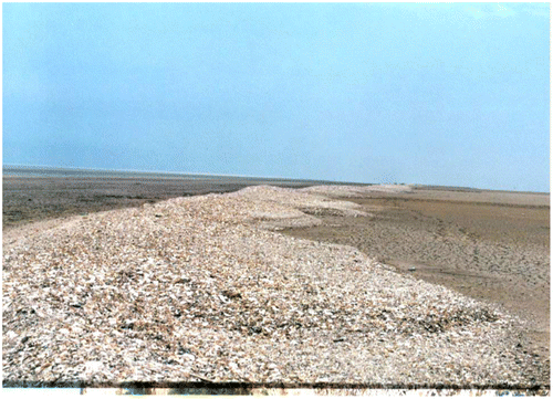
Holocene sea level withdraws at Hendijan delta leaved behind several paleo-shorelines which are evidences of the retrogressive sedimentary. Morpho dynamic feature of paleo-shorelines were accretion ridges which developed parallel to the present shoreline. Elevation and period for forming of each accretion ridge has controlled by late Holocene climate condition and Persian Gulf regional tectonic setting. Therefore, elevation of the oldest accretion ridge is 3 m above present Persian Gulf level. The most complete series of paleo-shorelines comprise eight accretion ridges (S0–S7) along the selected cross section (Figure ). Accretion ridges composed of sand beaches with coastal sedimentary structures. The mean height and width of accretion ridges were 2 and 60 m, respectively. Several shell spices are the main component ranging between 10 and 90% (Figure ). Shell contents points out late Holocene effects of climate variation, abundance detritus sediments, sea chemistry conditions and hydrodynamic regime. The sixth and seventh accretion ridges have completely composed from shells and shell debris in a high-energy environment. Such morpho dynamic features have been reported by a group scientist as Delta Chenier which arrange parallel to the shoreline by a wave-dominated condition (Richard & Davis, Citation1985). Therefore, dating of these features could represent the real-time interval between mid-Holocene climate changes and paleo-shorelines. Geochronology and real topographic results of dated paleo-shorelines is presented in Table .
Figure 1. Distribution of accretion ridges (paleo-shorelines) across Hendijan Delta.
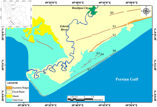
Figure 2. Morpho dynamic feature of paleo-shorelines at the Hendijan Delta (north of Persian Gulf).
A linear correlation between dates of paleo-shorelines and their position related to the present shoreline considered to estimate relative rate of shoreline mobility at Hendijan Delta. As a result, the shoreline regression rate from the S0, S1, S6, and S7 were of 3.71, 7.29, 0.63, and 0.61 m y−1, respectively. In the other word, the regression rate was 3.71 m y−1 between 2555 ± 114 and 999 ± 41 BP. The considerable regression was occurred between S1 and S6 at rate of 7.29 m y−1. Therefore, several accretion ridges (S2, S3, S4, and S5) were developed during just 306 years. Nevertheless, results highlighted the relatively stable regression rate of 0.6 m y−1 since 693 ± 17 years BP.
4. Discussion
Present research revealed the sedimentary retrogressive system since the mid-Holocene at the Hendijan Delta. As a result, continental sediments have overlaid on the coastal and marine deposits, respectively. Some researcher also has highlighted on the tectonic movements which has mainly contributed in sea level fall at the study area (Reyess et al., Citation1998). The Persian Gulf is the relatively narrow and shallow basin that has surrounded by the tectonically active Zagros area and Arabian Plate. This basin introduced as a nontectonic area and places for converging between Arabian and Eurasian plates, resulted in uplifting of northern coastal zone.
Several studies assumed that climate change is the effective parameter in the coastal changes (Hodell, Brenner, Curtis, & Guilderson, Citation2001; Kehl, Citation2009; Lambeck, Citation1996; Mayewski et al., Citation2004; Ramezani, Mohadjer, Knapp, Ahmadi, & Joosten, Citation2008). For example, six periods of significant rapid climate change (RCC) during the time periods 9000–8000, 6000–5000, 4200–3800, 3500–2500, 1200–1000, and 600–150 BP has introduced by a scientist (Mayewski et al., Citation2004). Besides, polar cooling, tropical aridity, and major atmospheric circulation changes between 600 and 150 BP have mainly contributed in the Holocene RCC. Some researcher also believes that RCC caused major disruptions of civilization, explaining the human significance of Holocene climate variability. Such disturbance of human also occurred about 900 BP and 350–400 BP at northern part of Iran (Haug, Hughen, Sigman, Peterson, & Rohl, Citation2001; Hodell et al., Citation2001).
A scientist developed the Glacial-Hydro-Isostatic model to rebuild Persian Gulf’s paleo-shoreline from the last glacial maximum (LGM) to 6000 cal BP. This model showed an exposure of the Persian Gulf surface from LGM until 11500 BP. Besides, the model represented the sea level rise from early Holocene which reached at maximum level about 6000 BP during Atlantic climatic condition. As a result, sea level settled 1–2 m above its present level and therefore low-lying areas of Persian Gulf flooded accordingly.
The RCC event was continued by sea level fall since 4500 BP. Therefore, several lakes (Hor Al-Howizah, Uzaim, Naaj, Shadegan) and marsh and wetlands have remained at the south of Iraq and reported the evidence for this event at 4300 BC in Lower Mesopotamia which occurred during three phases: 6500–5500 BP, 4500–3000 BP and 2000–1500 BP (Carter, Citation2010). Such period of time coincided with middle–late Holocene boundary which was introduced by stressed that time for reaching the Persian Gulf to its present shorelines not declared in the previous studies (Heyvaert & Baeteman, Citation2007; Sanlaville & Dalongeville, Citation2005; Walker, Citation2005). Therefore, achievement to the trend of shoreline mobility at north of Persian Gulf since 2555 ± 114 BP was the novelty of current research. Evidences reveal the clear climate change since 2555 ± 114 BP when the maximum regression rate of 7.29 m y−1was coincided with the extreme sediment supply from catchment area. Archaeological evidences clearly support settlement of people at a coastal village close to the S1 paleo-shoreline during Sassanian Empire (224–651 CE). In many ways, the Sassanid period witnessed the peak of ancient Persian civilization (Kanani, Citation2002). Human impacts should increase since 2555 ± 114 BP coincided with increase of navigation and fishery during and after Sassanid Empire. Therefore, a proper climate for developing of human settlements behind the first accretion ridge (S0) expected. Arranging of shells at 60 m width and 2 m height along the S6 and S7 since 693 ± 17 BP has pointed out suitable media for invertebrate growing. Overall increase in shell debris portion in sediments from S1 to S7 suggests the warmer aquatic media at the north of Persian Gulf. Arrangement of accretion ridges infers direction of dominated west-southerly wind regime. Overall direction of paleo-shoreline at Hendijan Delta signals the stable regional direction of coming wind since 2555 ± 114 BP. In addition, shoreline regression was stable at 0.6 m y−1 since 693 ± 17 BP that point outs the stable rate of sediment delivery from watershed area. The mean coastal uplifting of Hendijan Delta was 1.86 ± 0.77 mm y−1 which agrees with 2 mm y−1 uplift rate of Iranian continental margin due to subduction of Arabian plate (Vita-Finzi, Citation1980).
5. Conclusion
The late Holocene mobility of shorelines at Hendijan Delta (North of Persian Gulf) and its reasons was studied in this research. History of coastal zone since the late Holocene at the north of Persian Gulf was the vivid gap in the previous studies. A total of 8 (S0–S7) paleo-shorelines since 2555 ± 114 BP were created parallel to the present shoreline in the regressive sequence. Maximum regression rate was 7.29 m y−1 from S1 to S6 when S2, S3, S4, and S5 paleo-shorelines were developed during 306 years. This rate was supported by the large sediment supply by Zohreh River which has developed in the meandering pattern. An increase in the shell debris and organic matters in sediments of accretion ridges was highlighted in the present study. This fact, signals climate changes to Sub-Atlantic (Roman Warm Period) condition especially since 693 ± 17 BP. In addition, similar direction of paleo-shoreline pointed out the relative constant hydrodynamic regime since given time period at the north of Persian Gulf. Natural trend associated by human evidences which settlements were established behind of the first accretion ridge during the Sassanid Empire (224–651 CE). Present research highlighted differences between regression sequences at the study area and at the south of Persian Gulf because of different geological and topographic settings.
Disclosure statement
No potential conflict of interest was reported by the author.
Funding
This work was supported by the Soil Conservation and Watershed Management Research Institute, Tehran, Iran [grant number 42561].
Acknowledgement
The author offers his sincerest gratitude to the Soil Conservation and Watershed Management Research Institute, Tehran, Iran for the funding to succeed this research. The author also is grateful to colleagues of Coastal Protection Department for their help in the field work and official support. The author conveys his gratitude to Dr. M, Fontange for dating of samples by 14C method.
References
- Carter, R.A. (2010). The social and environmental context of neolithic seafaring in the Persian Gulf. In A. Anderson, J.H. Barrett, & K.V. Boyle (Eds.), The global origins (and development) of seafaring. Cambridge: McDonald Institute of Archeological Research.
- Coe, A., Bosence, D.W.J., Church, K.D., Flint, S.S., Howell, J.A., & Willson, R.C.L. (2003). The sedimentary record of sea-level change. Cambridge: Cambridge University Press.
- Delagrange, J. (1988). The south Persian Gulf coastal change. The Aquitanian, 92, 22–33.
- Falcon, N.L. (1947). Raised beaches and terraces of the Iranian Makran coast. Geographical Journal, 109, 149–151.
- Fisk, H.N. (1959). Padre Island and the Laguna Madre mud flats, coastal south Texas. In Proceedings of the Second Coastal Geography Conference (pp. 103–151). Washington, DC: National Academy of Science, National Reaserch Council.
- Gharibreza, M., Habibi, A., Imamjomeh, S.R., & Ashraf, M.A. (2014). Coastal processes and sedimentary facies in the Zohreh River Delta (Northern Persian Gulf). CATENA, 122, 150–158.10.1016/j.catena.2014.06.010
- Gharibreza, M., Karami, A., & Aghtoman, P. (2006). Effects of land remediation on deltaic sediment and hydrodynamic regime (case study: Hendijan Delta, sothwest Iran). In C. Protection (Ed.), Vol. 153. Tehran: Soil Conservation and Watershed Management Research Institute.
- Gharibreza, M., & Motamed, A. (2006). Late quaternary paleoshorelines and sedimentary sequences in chabahar bay (southeast of Iran). Journal of Coastal Research, 226, 1499–1504.10.2112/05A-0020.1
- Gharibreza, M., Motamed, A., Masoumi, H., Imamjomeh, R. (2008). The evolution of Persian Gulf coasts since mid-Holocene, case study of Zohreh River delta. In Proceedings 33rd International Geological Congress, Oslo, Norway.
- Haug, G.H., Hughen, K.A., Sigman, D.M., Peterson, L.C., & Rohl, U. (2001). Southward migration of the intertropical convergence zone through the Holocene. Science, 293, 1304–1308.10.1126/science.1059725
- Heyvaert, V., & Baeteman, C. (2007). Holocene sedimentary evolution and palaeocoastlines of the lower Khuzestan plain (southwest Iran). Marine Geology, 242, 83–108.10.1016/j.margeo.2007.01.008
- Hodell, D.A., Brenner, M., Curtis, J.H., & Guilderson, T. (2001). Solar forcing of drought frequency in the Maya lowlands. Science, 292, 1367–1370.10.1126/science.1057759
- Jamab, E.C. (1999). Iran integrated water plan, Zohreh River watershed. In W. Research (Ed.) Tehran: Ministry of Energy.
- Kanani, A. (2002). History & geography of an ancient civilization from Arjan to Ghaban: Tehran, Navid Press.
- Kehl, M. (2009). Quaternary climate change in Iran – The state of knowledge. Erdkunde, 63(1), 1–17.10.3112/erdkunde
- Lambeck, K. (1996). Shoreline reconstructions for the Persian Gulf since the last glacial maximum. Earth and Planetary Science Letters, 142, 43–57.10.1016/0012-821X(96)00069-6
- Mayewski, P.A., Rohling, E.E., Stager, J.C., Karlen, W., Maasch, K.A., Meeker, L.D., … Steig, E.J. (2004). Holocene climate variability. Quaternary Research, 62, 243–255.
- McBride, R.A., Taylor, M.J., Byrnse, M.R. (2007). Coastal sediments. In Proceedings The Sixth International Symposium on Coastal Engineering and Science of Coastal Sediment Processes, New Orleans, Louisiana, 4, American Society of Civil Engineers.
- Pirazzoli, P.A. (1991). World atlas of Holocene sea-level changes. Amsterdam: Elsevier.
- Ramezani, E., Mohadjer, M.R.M., Knapp, H.D., Ahmadi, H., & Joosten, H. (2008). The late-Holocene vegetation history of the Central Caspian (Hyrcanian) forests of northern Iran. The Holocene, 18, 307–321.10.1177/0959683607086768
- Reyess, J.L., Pirazolly, P.A., Haghipour, A. (1998). Quaternary marine terraces and tectonic uplift rates on the south coast of Iran. France, Centre des Faibles Radioactivites (CNRS-CEA), 146, 225–237.
- Richard, A., & Davis, J.R. (1985). Coastal sedimentary environments. New York: Springer-Verlag, 2, 716.
- Ruggiero, P., Kratzmann, M.G., Himmelstoss, E.A., Reid, D., Allan, J., & Kaminsky, G. (2013). National assessment of shoreline change-historical shoreline change along the Pacific Northwest coast. Reston, VA: U.S. Geological Survey Open-File.
- Sanlaville, P., & Dalongeville, R. (2005). L’évolution des espaces littoraux du golfe Persique et du golfe d’Oman depuis la phase finale de la transgression post-glaciaire. Paléorient, 31, 9–26.
- Vita-Finzi, C. (1979). Contributions to the quaternary geology of southern Iran. (Vol. 47, pp. 30–47). Tehran. Geological and mineral survey of Iran.
- Vita-Finzi, C. (1980). 14C dating of recent crustal movements in the Persian Gulf and Iranian Makran. Radiocarbon, 22, 763–773.10.1017/S0033822200010134
- Walker, M. (2005). Quaternary dating methods. Chichester: John Wiley & Sons.
- Weninger, B., & Jöris, O. (2008). A 14C age calibration curve for the last 60 ka: The Greenland-Hulu U/Th timescale and its impact on understanding the Middle to Upper Paleolithic in Western Eurasia. Journal of Human Evolution, 55, 772–781.10.1016/j.jhevol.2008.08.017