
Abstract
Through field investigation and test, the distribution characteristics, formation conditions, and starting mode of the typical mine debris flow in Tieshanzhang Mining Area were studied, and the density, flow velocity, flow, and other dynamical parameters of the debris flow were calculated based on the dynamic principle, which provided a reliable basis for the design of debris flow prevention engineering. The results showed that the debris flow was currently in the development stage, belonged to the rainstorm gully-shaped, high-frequency, non-viscous, mining slag debris flow, and its starting mode was collapsing-jamming-bursting type. From the topography point of view, large relative height difference of the gully basin, steep terrain, and large longitudinal slope of the gully helped the formation and starting of the debris flow; from the source point of view, arbitrary discharge of large-scale mining waste provided a rich loose solid source for the debris flow; heavy rainfall brought by landing of typhoon was a trigger for the debris flow.
Mining in China, with a long history, plays an important fundamental role in the national economic and social development. However, the local geological environment and ecological environment in some areas are destroyed during exploitation and utilization of mineral resources due to a lack of systematic planning and scientific management by their governments. Arbitrary dumping of waste rock, waste soil, tailings produced from mining activities cause or aggravate a series of mine geo-environment problems such as mine debris flow, a typical mine geological disaster.
Mine debris flow is one of man-made debris flows. Compared with natural debris flow, it is characterized by man-made source, diverse type, vulnerability, high frequency, catastrophic destruction, indirect pollution, and risk avoidance (Xu et al., Citation2010). Researches (Zhong, Yan, & Chen, Citation1981) found that debris flow has occurred in almost every large mine in China, and many times in some mines. During 1958–2005 alone, 609 debris flows struck mines in China, killing 680 persons in total, according to incomplete statistics (Xi’an Institute of Geology & Mineral Resources, Citation2005, 2009a, 2009b).
Therefore, it is necessary to study the formation conditions, starting mode, and movement characteristics of mine debris flow, which will be of great significance for its prevention and mitigation. Many scholars at home and abroad have conducted a lot of researches on them. Zhong et al. (Citation1981) first proposed the concept of “mine debris flow” in 1981. Zhaoshu (Citation1995) and Shijian, Hong, Fangqiang, and Hongjiang (Citation1996) studied the characteristics of the mine debris flow in Xiaoqinling Gold Field in 1995 and 1996, respectively. In 2006 Xu, Du, He et al. (Citation2006) put forward the concept of “mining slag debris flow” according to the characteristics of the mining waste slag in Xiaoqinling Gold Field–“coarse particle gradation, rigid rock, non-connection, large porosity and high permeability”, and in 2015, he studied (Xu, Chen, Yang et al., Citation2015) the control effect of the particle size of the mining waste slag on the starting of mining slag debris flow. Zhang (Citation2013) discussed the whole process of the break of tailings dam from two perspectives, namely the instability of tailings dam and the evolution of debris flow. Ulusay, Arikan, Yoleri, and Çaǧlan (Citation1995) discussed the geotechnical engineering properties of slag heaps of the coal mines in southwest Turkey. Chen et al. (Citation2010) discussed the relationship between different clay content and the instability of soil mass and the formation of debris flow by experiment. Compared to the rich research achievements of natural debris flow, the research of mine debris flow still remains in the initial stage, and puts more emphasis on the risk assessment of debris flow hazard (Ballesteros Cánovas et al., Citation2016; García-Torres, Kahhat, & Santa-Cruz, Citation2017). In this paper, the movement characteristics and starting mode of the mine debris flow in Tieshanzhang under typhoon were studied from the perspective of the particularity of solid source and hydrodynamics.
1. Overview of research region
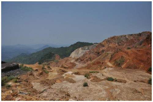
Tieshanzhang Mining Area is a medium-sized iron ore mining area in Xingning City, Guangdong Province, China. It is located at E115°47′41″–115°48′34″,N24°20′29″–24°21′09″, and is easy for open-pit mining as its ore body is exposed to surface. The mine has been mined since 1958 and in normal mining phase by 1984, during which the mining slag was dumped randomly due to a lack of understanding of geological disasters; during 1985–2005 large-scale private mining activities took place (Photos and ), thus the mine was in the disorderly mining phase, which exacerbated the development of geological disasters; the mining ceased in 2005.
1.1. Situation of disasters
The long-term disorderly mining of mine and random discarding of waste rock and waste soil results in widespread development of geological disasters in Tieshanzhang Mining Area. In the mining area, a series of loose accumulation slopes subject to serious water and soil erosion have been formed, especially during the rainy season, collapse, landslide, debris flow, and other geological disasters occur from time to time. According to the survey, different sizes of debris flows occur in the mining area almost every year, so it is a high frequency debris flow gully. Fortunately, the debris flow did not pose a direct threat to the downstream residents thanks to two dams in the gully basin built by the local government. But with the passage of time, the storage capacity of the dams decreased year by year. As a result, the small scale debris flow that broke out in July 2010 flooded over 10 mu of farmland and destroyed 50m of highway. In 2011, the clarification pond and silt reservoir were desilted, and the dams were heightened to expand their storage capacity, and small drainage grooves were built in the lower reaches. However, the debris flow broke out under the typhoon “Utor” in August 2013 that hit a record high in scale, which caused serious siltation to the dams, only 5% of the existing storage capacity of the dams to the original storage capacity of the dams, and destruction to embankments, highways as well as downstream farmlands and water conservancy facilities, seriously threatening the personal and property safety of 2173 persons in the 4 administrative villages in the lower reaches.
1.2. Climate and rainfall
Tieshanzhang Mining Area, located at low latitude, has a subtropical climate. Due to southeast monsoon, it is characterized by strong solar radiation, short winter and long summer, abundant sunshine, annual mean temperature of 20.4°, long frost-free period, and a lot of disastrous weather. In terms of spatial distribution, the rainfall is large in the north and small in the south; in terms of time distribution, the rainfall is uneven, with most rainfall between March and September, an 84.27% of rainfall all the year round. The statistical data of annual rainfall and daily maximum rainfall in Xingning city during 1994–2013 are shown in Figure .
Figure 1. Variation of annual rainfall and daily maximum rainfall in Xingning city during 1994–2013.
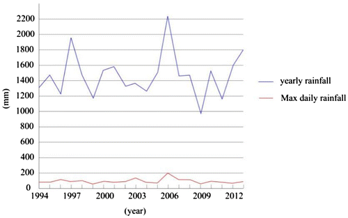
Figure 2. Rainfall statistics of some rainfall stations in Xingning city during the typhoon “Utor”.
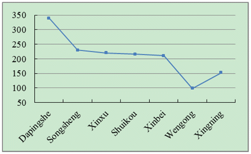
Figure 3. Distribution of debris flow in Tieshanzhang.
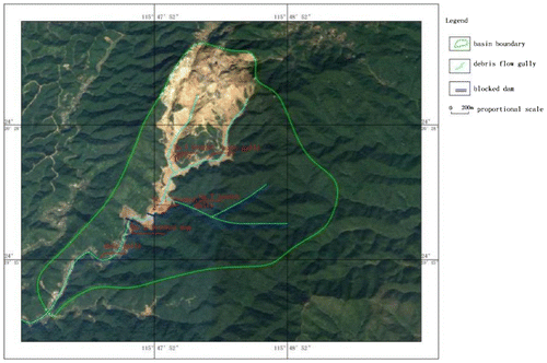
Figure 4. Profile of main gully in Tieshanzhang.
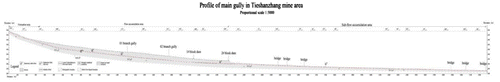
Figure 5. G11-G11′ section.
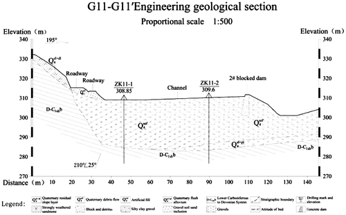
Photo 1. Disorderly private mining in history.
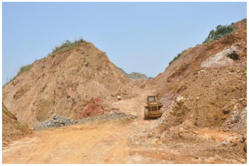
Photo 2. Mining waste slope.
1.3. Terrain and topography
Tieshanzhang Mining Area, surrounded by hills, belongs to a low mountain and hill landform, with the highest mountain of 827 m, and the mountains in it are mostly low mountains ranging from 600 to 800 m. Due to obvious denudation and cutting, it features numerous steep slopes, whitewater waterfalls, V-shaped valleys, and other tectonic eroded landforms. The terrain is high in the southeast and low in the northwest, with a terrain slope of 20°–45°, local steep terrain, developed gully, large water catchment area, and large runoff coefficient. Under intensive rainfall, it is easy to form a larger water source in a short period of time to provide a powerful hydrodynamic force for the starting of debris flow.
2. Research methods
The area of the research region was about 5.53 km2, including the debris flow gully basin and its area of influence. The field investigation focused on geological conditions, source conditions, and hydrodynamic conditions; the research contents included the movement characteristics, source transformation, and starting mode of debris flow; the exploration methods and technical means included topographic survey, typical section survey and mapping, drilling engineering, geophysical prospecting engineering and debris flow unit weight proportioning test, water quality analysis, and so on.
According to site requirements, 35 boreholes were drilled, with a total drilling meterage of 1099.4 m; a heavy dynamic penetration test was conducted in 6 places to determine the rock and soil mechanics parameters of the deposits, so as to provide a reliable parameter basis for the design of later debris flow prevention engineering; to determine the overburden thickness of waste rock and waste soil accumulation slope, 12 sections with a total length of 2.73 km were constructed using resistivity method; to determine the unit weight of debris flow, 6 groups of field debris flow unit weight proportioning tests were conducted; 6 groups of 12 water samples in the main gully and each branch gully were analysed.
3. Research results
3.1. Formation conditions of the debris flow in Tieshanzhang Mining Area
3.1.1. Solid source
The field investigation showed that the loose solid source in the research region was rich, which was mainly artificial spoil-filled soil deposit and original gully deposit formed by mining. The gully deposit was obviously the mining waste slag produced by exploitation of iron ore, indicating that it mainly came from the upper reaches of the mining area, where the clastic fragments were carried to the debris flow gully after years of scouring by constant water. In view of a large amount of mining waste slag in the mine debris flow source, the study by Xu et al. (Citation2010) showed that the characteristics of the mining waste slag itself enlarges the disaster effect of debris flow, which is also an important difference between the mine debris flow and natural debris flow.
| (1) | Source of spoil-filled soil accumulation slope | ||||
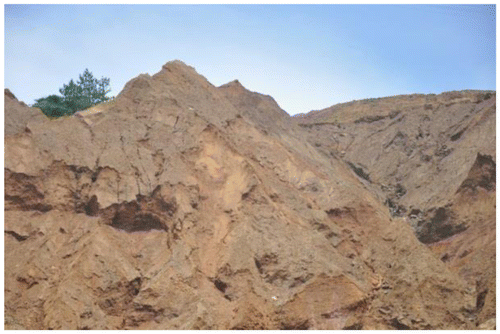
The serious damage to vegetation caused by mining had greatly changed the terrain and topography (Photos and ). The artificial slopes were steep and had poor stability, thus were prone to deformation and instability failure in extreme weather, and then changed into a new solid source of debris flow to enter debris flow gully to participate in debris flow activities. In the research region, such artificial slopes were widely distributed and large in size, thus were the main loose solid sources of debris flow.
| (2) | Source of deposits in the gully | ||||
Photo 3. Developed gully.
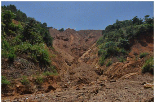
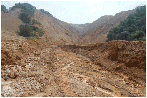
Photo 4. Mining waste slag accumulation slope.
The deposits in the gully were mainly alluvial deposits and surface debris flow deposits on the gully bed (Photos and ), which participated in debris flow activities in a way that initiated bottom tearing scoring of gully bed. Loose deposits in the gully, large water catchment area, and steep slopes on both banks were conducive to runoff and catchment of surface precipitation. Also, the scouring was more intense under heavy rainfall due to short catchment time and good hydrodynamic condition.
Photo 5. Deposits in the gully.
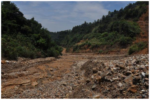
Photo 6. Source of deposits.
According to field investigation and analysis, the dynamic reserve of sources only accounted for 5.74% of the total reserve of sources, just a small proportion. The reason was that although there were a large number of deposits in the gully, they were gradually compressed and consolidated under the action of their self-weight. By detecting, the soil 2 m below the surface was slightly dense. Part of the deposits gradually deposited in the circulation process on account of long and winding gully as well as restriction by longitudinal slopes and dams.
According to the data statistics of boreholes, the reserve of loose solid sources accumulated in the gully basin was about 286.81 × 10⁴ m3, in the gully was about 648.27 × 10⁴ m3, the total reserve was about 935.17 × 10⁴ m3, and the dynamic reserve of loose solid sources that can participate in debris flow activities was 98.77 × 10⁴ m3.
3.1.2. Water source
Tieshanzhang Mountain is an isolated mountain without big source flows, where only creeks are radially distributed. Five stationary water sources developed all year round in the gully basin, mainly phreatic water or bedrock fissure water, are distributed in the main gully, 01 branch gully, 001 branch gully, right side of 001 branch gully, and 02 branch gully, respectively. The groundwater is mainly Quaternary loose rock pore water and massive rock fissure water, which mainly accepts infiltration recharge of atmospheric precipitation, and varies greatly with the season. The formation of debris flow in this area was mainly restricted by hydrodynamic force that mainly came from rainfall.
| (1) | Rainfall during the typhoon | ||||
Local heavy rainfall caused by typhoon may cause large-scale geological disasters. Studies have shown that (Wang, Guo, Du et al., Citation2012): the larger the height difference of terrain, the smaller the critical rainfall; the worse the slope stability, the smaller the rainfall exciting landslide and debris flow. During the typhoon “Utor” during 13–19 August 2013, the rainfall statistics of some rainfall stations in Xingning city are shown in Figure .
Referring to the research results in similar regions of China (Zhang, Yao, Guo et al., Citation2016; Zhao & Song, Citation2011), the critical rainfall exciting landslide and debris flow in this region was daily rainfall ≥ 50 mm or accumulated rainfall in early stage (1–10d) ≥ 100 mm. During the typhoon, the continuous rainfall in Tieshanzhang had reached the rainfall threshold starting debris flow.
| (2) | Water quality analysis | ||||
The analysis results of heavy metal content in water showed that heavy metal pollution was serious in this region, as the contents of Zn, Mn, and Al were up to 41.8, 67.5, and 159.5 mg/L, respectively, which were far higher than drinking water standard (Standardization Administration of the People’s Republic of China’s, Citation2006).The total hardness, dissolved hardness, and chemical oxygen content of water were 4–20 times of those of drinking water, with pH of 2.12. The groundwater had strong corrosion to concrete structure and reinforcement due to its strong acidity, which to a certain extent reduced the dams’ effectiveness and shortened the dams’ service life. The water quality analysis results of the main gully and each branch gully showed that the contents of , Cl−, K+, Na+, Ca+, and Mg+ were high, and the TDS in the 01 branch gully was as high as 18,148.09 mg/L, indicating poor water quality, which was related to triggering debris flow. As the heavy metals moved with runoff under the leaching action of rainfall, the interaction between ions exacerbated water and soil erosion, leading to the occurrence of debris flow (Zhang, Wang, & Zhao, Citation2013).
Chemical Water-Rock Interaction, one of the main types of water-rock interaction, not only plays a key role in the process of mineralization, diagenesis, soil formation, and CO2 cycle, but also is an important factor inducing a variety of geological disasters. The study by Chen (Citation2006) showed that CWRI made a significant contribution to the development of landslide. Tieshanzhang Mining Area featured rich mineral elements, adequate rainfall, intense CWRI, all of which promoted the development of landslide, and new solid source transformed from landslide was one of the important means of debris flow source recharge in this region. Therefore, unreasonable dumping of waste rock and waste soil in the mining area resulted in negative effects on the surrounding environment, which increased the occurrence frequency of geological hazards such as landslide and debris flow in the process of CWRI and enlarged their scale.
3.1.3. Terrain
The main gully was 5.03 km in length and the whole gully basin looked like a “Ya pear” (Figure ). With abundant bends, most of the gullies were open “U-shaped” gullies with a width of 45–120 m, and the water system was simple. The 01 branch gully converged with the main gully at an acute angle at an elevation of 380 m, and continued to participate in debris flow activities after converging into the main gully; the 02 branch gully converged with the main gully at an almost acute angle at an elevation of 345 m, which was mainly water source converging, with an elevation of 225–484 m, and a height difference of 259 m. The longitudinal slope gradient of the main gully and local gully bed was 61.49 and 315.96‰, respectively, especially a vertical landform with a height difference of about 35 m formed at 2# dam provided good potential energy conditions for the formation of debris flow. Based on the terrain feature of the gully combined with existing debris flow control measures, the gully of Tieshanzhang was divided into three areas, namely formation area, circulation accumulation area, and sub-circulation accumulation area, as shown in Table and Figure .
Table 1. Zoning characteristics of debris flow in the gully in Tieshanzhang.
3.2. Movement characteristics
The flow velocity, flow, and total one-time discharge of debris flow were important dynamic conditions. The G11-G11′ section (Figure ) of mouth of the main gully with typical section was selected to calculate the characteristic value of debris flow. The unit weight of debris flow was calculated to be 1.61t/m3 by using empirical formula (Yu, Citation2009) and look-up table method combined with field test (Photo ). As crushed rock mingled with sand clay were the main materials of debris flow, the debris flow belonged to the non-viscous debris flow (DZ/T 0220-Citation2006, 2006). The flow velocity of debris flow was calculated using the improved formula (Hong, Citation1996) of the Southwest Institute of China Academy of Railway Sciences, and the flow of debris flow was calculated using Dongchuan formula (Wu, Kang, Tian et al., Citation1990), and the impact pressure of debris flow was calculated using the overall impact pressure formula (Shen, Xie, Xiang et al., Citation1996) of debris flow, and the parameter values of debris flow are shown in Table . Where the hydraulic radius was replaced by the average mud depth, the hydraulic gradient of debris flow was replaced by the longitudinal gradient of gully bed.
Photo 7. Field unit weight test.
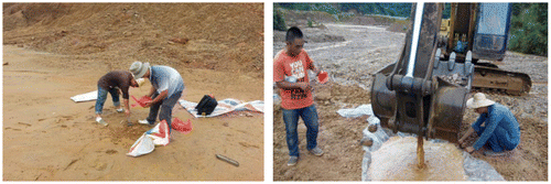
Table 2. Parameter values.
After calculation, the flow velocity, peak flow, total one-time discharge, and overall impact pressure of the debris flow in Tieshanzhang were 2.85 m/s, 314.27 m3/s, 14.93 × 10⁴ m3, and 16.4 kPa, respectively.
3.3. Starting mode
The formation process of the debris flow in Tieshanzhang: The main gully and the 01 branch gully formed two large debris flows, and overlapped each other at their confluence. Because the 01 branch gully had richer source condition and larger runoff coefficient, it was prone to viscous debris flow; because the main gully had larger water catchment area and stronger hydrodynamic conditions as well as relatively few sources, it was prone to non-viscous debris flow. The accumulation characteristics of alluvial fan caused obvious extrusion effect of the debris flow in the 01 branch gully on the debris flow in the main gully, after short accumulation and siltation stopped, the massive debris flow source provided by the 01 branch gully was restarted under the strong hydrodynamic conditions of the main gully to complete the discharge and accumulation process of debris flow in the relatively wide circulation accumulation area with an increasingly longitudinal slope.
According to field investigation, analysis, and calculation, the spoil-filled soil accumulation slope, with the reserve of unstable source of 1,252,300 m3, was prone to instability failure to participate in debris flow activities under heavy rainfall and persistent rainfall. It was consistent with the findings by Jiang (Citation2007), Chen, Cui, Feng, Chen, and Li (Citation2006) that the starting of landslide and the formation of debris flow were a continuous process. The reserve of deposits that can participate in debris flow activities in the gully was 384,500 m3, and the deposits participated in debris flow activities in a way that initiated bottom tearing scoring of gully bed. The down-cutting of pull trough at the bottom of gully led to the instability of slopes on both banks to participate in debris flow activities.
In summary, the starting mode of the debris flow in Tieshanzhang was collapsing-jamming-bursting type. The unstable mining waste slag dump collapsed or was subject to instability failure from its toe, and then entered into the river to flow with the mountain torrent, which blocked the river to form debris flow.
4. Conclusion
The mine debris flow in Tieshanzhang, belonged to the rainstorm gully, high frequency, non-viscous, mining slag debris flow, and its starting mode was collapsing-jamming-bursting type. Disorderly mining of mine and rough random dumping of mining slag were the basic conditions of debris flow in the gully; the negative effects of mine mining on the environment promoted the formation of geological disasters. Heavy rainfall brought by the landing of typhoon was a trigger for the debris flow. The reserve of loose solid sources accumulated in the gully basin was about 2,868,100 m3, about 6,482,700 m3 in the gully, the total reserve was about 9,351,700 m3, and the dynamic reserve of loose solid sources that can participate in debris flow activities was 987,700 m3. After calculation, the unit weight, flow velocity, peak flow, total one-time discharge, and overall impact pressure of the debris flow in Tieshanzhang were 1.61t/m3, 2.85 m/s, 314.27 m3/s, 149,300 m3, and 16.4 kPa, respectively. Thereby, the prevention measures like regular clean up of waste residue in flood passage and construction of drainage were proposed.
Disclosure statement
No potential conflict of interest was reported by the authors.
Funding
This work was financially supported by the Fundamental Research Funds for the Central Universities (NO: lzujbky-2017-169).
References
- Ballesteros Cánovas, J.A., Stoffel, M., Corona, C., Schraml, K., Gobiet, A., Tani, S., … Kaitna, R. (2016). Debris-flow risk analysis in a managed torrent based on a stochastic life-cycle performance. Science of the Total Environment, 557–558, 142–153.10.1016/j.scitotenv.2016.03.036
- Chen, J.P. (2006). Chemical water-rock interaction & contribution to landslide preparation process ( Master dissertation of Civil Engineering from Kunming University of Science & Technology, China).
- Chen, N.S., Zhou, W., Yang, C.L., Hu, G.S., Gao, Y.C., & Han, D. (2010). The processes and mechanism of failure and debris flow initiation for gravel soil with different clay content. Geomorphology, 121(3/4), 222–230.
- Chen, X.Q., Cui, P., Feng, Z.L., Chen, J., & Li, Y. (2006). Artificial rainfall experimental study of landslide translation to debris flow. Chinese Journal of Rock Mechanics and Engineering, 25(1), 106–116.
- DZ/T 0220-2006. (2006). Specification of geological investigation for debris flow stabilization. Beijing: Standards Press of China.
- García-Torres, S., Kahhat, R., & Santa-Cruz, S. (2017). Methodology to characterize and quantify debris generation in residential buildings after seismic events. Resources, Conservation and Recycling, 117(B), 151–159.10.1016/j.resconrec.2016.11.006
- Hong, Z.X. (1996). The discussion on formulae for calculating velocity of the debris flow. The Chinese Journal of Geological Hazard and Control, 7(1), 26–33.
- Jiang, Z.X. (2007). Current velocity calculation of debris flow based on excess-height in bend. Geotechnical Engineering Technique, 21(6), 288–291.
- Shen, S.C., Xie, X., Xiang, X., et al. (1996). On estimation of debris flow discharges. China Railway Science, 14(6), 80–89.
- Shijian, L., Hong, X., Fangqiang, W., & Hongjiang, L. (1996). A man-caused debris flow in Xiaoqinling gold mining region. Mountain Research, 14(4), 259–263.
- Standardization Administration of the People’s Republic of China. (2006). GB5749-2006 standards for drinking water quality. Beijing: Ministry of Health of the People’s Republic of China.
- Ulusay, R., Arikan, F., Yoleri, M.F., & Çaǧlan, D. (1995). Engineering geological characterization of coal mine waste material and an evaluation in the context of back-analysis of spoil pile instabilities in a strip mine, SW Turkey. Engineering Geology, 40(1–2), 77–101.10.1016/0013-7952(95)00042-9
- Wang, Z.H., Guo, Z.C., Du, M.L., et al. (2012). Model study of predicting rainstorm induced landslide and debris flow at Niumian Gully, the focal area of 2008-05-12 earthquake. Earth Science Frontiers, 19(1), 228–238.
- Wu, J., Kang, Z.C., Tian, L., et al. (1990). Study on observation of Jiangjiagou debris flows in Yunnan Province. Beijing: Science Press.
- Xi’an Institute of Geology and Mineral Resources. (2005). Special investigation on mine environmental geologic problems of Xiaoqinling gold mine ( Report No. 200412300057-1). Shanxi: Xi’an Center of China Geological Survey.
- Xi’an Institute of Geology and Mineral Resources. (2009a). 1:4000000 mine environmental geologic map of China. Shanxi: Xi ‘an Map Press.
- Xi’an Institute of Geology and Mineral Resources. (2009b). Investigation and evaluation on mine environmental geologic problems of Xiaoqinling gold mine ( Report No. 1212010741003). Shanxi: Xi'an Center of China Geological Survey.
- Xu, Y., Du, S., He, F., et al. (2006). Mullock type debris flow hazards and suggestions for prevention in Tongguan gold mine area. Journal of Mountain Science, 24(6), 667–671.
- Xu, Y.N., Chen, H.Q., Yang, M., et al. (2015). Controlling role of particle sizes of mining waste residues in the initiation of mine debris flow: A case study of the Xiaoqinling gold mining area. Geological Bulletin of China, 34(11), 1993–2000.
- Xu, Y.N., He, F., Zhang, J.H., Chen, H.Q., Xu, D.Y., Yang, M., & Qiao, Y.J. (2010). Characteristics and strategy for prevention and reduction of mine debris flow. Journal of Mountain Science, 28(4), 463–469.
- Yu, B. (2009). Research on the improved calculating density of less viscosity debris flows. Journal of Mountain Science, 279(1), 70–75.
- Zhang, L. (2013). Summary on the dam-break of tailing pond. Journal of Hydraulic Engineering, 44(5), 594–600.
- Zhang, Y., Wang, Y., & Zhao, X. (2013). Relationships between soil and water loss and geological disasters in Binxian-Changwu mining area of Shanxi Province. Bulletin of Soil and Water Conservation, 33(5), 305–308.
- Zhang, Y.S., Yao, X., Guo, C.B., et al. (2016). Regional warning of debris flow hazards after Wenchuan earthquake in Longmenshan region. Journal of Southwest Jiaotong University, 51(5), 1014–1023.
- Zhao, H., & Song, E.X. (2011). Rainfall thresholds for regional landslides. Journal of Jilin University (Earth Science Edition), 41(5), 1481–1487.
- Zhaoshu, L. (1995). A Study on the mud-rock flow disaster in 1994 in the gold mine area of Tongguan Shanxi. Journal of Catastrophology, 10(3), 51–56.
- Zhong, D., Yan, R., & Chen, J. (1981). Preliminary study on mine debris flow (pp. 43–49). Chongqing: Chongqing: Scientific and Technical Documents Publishing House, Institute of Geographic Sciences, Chengdu, CAS, Disquisition on Debris Flows.