
Abstract
One of the most sensitive issues that must be considered in many decisions are environmental factors. Planning for the optimal use of land makes it possible to maintain natural resources for using in future by the Earth too. Locating is one of the most widely used spatial decision-making which can be influenced by many environmental factors. The aim of the locating is to find a set of appropriate spatial options for a particular application. The locating issue is a multi-criteria decision-making problem. In current article, we have used OWA land-capability classification using GIS in order to prepare, evaluate, classify and overlay the layers. We have used six parameters of height, land use, climate, soil, slope and tilt direction for evaluating and categorizing land power. Finally, the areas that indicates the best potential of farming and other classes have been identified.
1. Introduction
Any exploitation of the land that we are above capable of in the long run will destroy and reduce fertility. Thus, it us vital to recognize land production capacity and allocate it to the best and most profitable type of using. Planning for optimal land usage makes it possible to preserve natural resources for future use by the Earth too (Leopold, Citation1968). To do this, land resources must be identified first and their capacities and capabilities must be determined for possible uses. This kind of studies can be made in the form of land plot plans too, because in discussing land management and the discussion is about the proper use of resources and land, which is necessarily a kind of adaptation of suitable land usage and is a special advantage to this. It is according to a quantitative assessment based on expert judgement and a quantitative assessment according to the predetermined stages (model) (Van Beek, Citation2009). Murphy (Citation2004) studied the land and land suitability in veils, and in his research he had studied the impacts of work and land management on the soil, where the adaptation among soil and its properties is low for the national parks and protected areas, and recommend wherever it is adapted to agriculture and rangelands. The evaluation history in Iran dates back to 1935. To achieve this aim, a recipe had been prepared by Iranian experts and FAO experts, including Mahler, which had been used until 1949, and in the year 1949, the recipe had been labelled with guides Land classification had published by the Soil and Water Research Institute, known as the 205 Technical Journal. Karamiyan, Onaq, and Payamati (Citation2008). In his research entitled “Land Use Management Program of Kouhdasht Lorestan,” has used land surveying for studying and adapting the current status of land use planning (capacities or capability) and had concluded that in 34% of the area of this area are work usage. There is a slight correlation between these two factors. In the mid-1990s, the FAO introduced a method which was called “AEZ-zoning,” whereby the Earth’s surface, according to physical parameters, has divided into more or less homogeneous regions for the production of important crop products. In current study, the modified Mahler method (evaluation of Iranian lands) has been used for calibrating the physical and climatic conditions of Iran in order to obtain more accurate results (Tavakkol, Citation1997).
Decision-making can be considered as the vital challenge facing experts and analysts to solving a variety of problems. Therefore, various methods and algorithms have been indicated for supporting the decision-making over the last few decades. Multi-criteria decision-making issues usually consists of a set of location that must be according to several criteria in GIS as a process that determines spatial data (maps) and valuation values (priorities and criteria of analysts). In better words, the MCDA suggests a specific model to optimize spatial decision-making, and many studies have been done so far. Heywood, Oliver, and Tomlinson (Citation1995) recommended multi-criteria analyses in GIS, it consists of a comparison of the results obtained from various decision rules.
Jankowski, Andrienko, and Andrienko (Citation2001) used the multi-criteria DECADE/Common GIS analysis on decision-wing search and discovery stressed.
It is notable that, many studies have been done on multivariate statistics in multi-criteria evaluation methods too (Andrienko, Andrienko, & Jankowski, Citation2003). Providing location mapping and evaluating various areas is one of the most useful GIS applications for spatial planning and management (Collins, Steiner, & Rushman, Citation2001). During the last decade, the issue of locating suitable applications has been used in multi-criteria evaluation methods in GIS increasingly, (Barredo, Benavides, Hervás, & van Westen, Citation2000; Dai, Lee, & Zhang, Citation2001; Joerin, Thériault, & Musy, Citation2001). The conventional methods of multi-criteria analysis in GIS, like boolean overlapping operators and weighted linear composition methods, have been used in several locational and land use assessment problems too (Beedasy & Whyatt, Citation1999).
These methods have also combined with the weighted average weighting principles in various applications (Makropoulos, Butler, & Maksimovic, Citation2003).
The outcomes obtained from the application of multi-criteria evaluation methods, that include boolean overlapping operators and weighted linear constituents, can be determined by the use of the weighted average weighted average (OWA) method that had been improved. Conventional and traditional methods of OWA have been used in many GIS spatial applications (Calijuri, Marques, Lorentz, Azevedo, & Carvalho, Citation2004). OWA is a family of multi-criteria combination methods (Yager, Citation1988).
This method consists of two categories of weights: weights belongs to relative importance of criteria and sequential weights. Rinner and Malczewski have developed the ability of supporting the decision-making by adding an OWA module to Common GIS. Thou, the studies have indicated that conventional OWA methods have limited impacts when they have broad evaluation criteria. In these situations, the combination of criteria in such a way that assumptions are decisive will be very complicated.
For many criteria, the person encounters the issue of combining the criteria maps to the extent that their outcomes meet the priorities. In such cases, the key aspects of the decision issue may be indicated in terms of some fuzzy conceptual quantities such as “Most criteria must be estimated” or “80% of the criteria must be met.” This needs a change in the multi-criteria decision-making methods, thus the conditions of these fuzzy quantities can be met (Boroushaki & Malczewski, Citation2008).
2. Material and methods
First of all, the natural features of the Roudehen area had been studied. This study consist of topographic, slope, climatic characteristics, soil talent, land use and orientation and the area of Roudehen in terms of agricultural land by considering the OWA method has been studied in GIS.
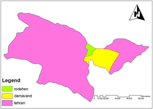
Case Study of Area: Roudehen district, Damavand city, Tehran province.
2.1. Introducing the Roudehen section
The Roudehen section is 35 km North-east of Tehran province and in the foothills of southern Alborz southern wall. The average height of the town is 1850 m and its area is over 200 km2. The area is between 55 and 51 and latitude 43 and 35. More precisely, the northern boundary is formed by the mountain ridge of the north of Lavasan to the hill of Emamzadeh Hashem. From the south, the mountains of Quch mountain, Suri Qal’eh and … have separated this region from the central region of Iran. It has mild climate. Roudehen section is in north of Amol city in Mazandaran province, and from the east it has neighbourhood with central part of Damavand, and from the west it has neighbourhood with the central part of Tehran (with Boumehen and Pardis town) and from the south it has neighbourhood with the mountains and Varamin and Pakdasht deserts (Figure ).
Figure 1. Location of the studied area.
2.2. Research methodology
2.2.1. OWA
Multi-criteria evaluation methods in GIS usually consist of a set of spatial assessment criteria in the form of maps and layers. But the problem that normally happens in spatial decision-making is how to combine the criteria maps with a set of descriptive values (weights) beside decision-makers’ preferences. Spontaneous decision-making must lead to the selection of one (or multiple options are spatial options. Each of these options, (i = 1, 2, …, m), is described with a standardized set of values (aij). The multi-criteria evaluation question consists of a priority set as a weight of the criteria too,
[0,1] = WIJ for j = 1, 2, …, n with map layers and standard weights, the OWA combination operator to the cell location i is a set of sequential weights v0 = v1, v2, …, vn assigns, since for each j = 1, 2, …, n we will have. The OWA combination operator is defined as follows (Yager, Citation1988):
where in that by sorting the
Descriptive values are achieved and uj is the same weight criterion that is sorted due to the order of zij. As you can see, two types of weight have been used in this method: critical weights and sequential weights. The weight of the critical indicates the relative importance of each evaluation criteria (layers and maps), but sequential weights are allocated according to the location of the cells of the layers and trays. It means that all cells in the same position in several criteria maps will have the same combined weights. Thus, all cells share a common weight in a nap, but there are varieties in their sequential weight. The equation may be the same as the “weighted linear composition” in which the standard weights have been changed.
OWA combination with quantitative fuzzy concepts.
With a set of criteria maps and a quantizing fuzzy concept, Q can be used to combine maps with a “phrase” in relation to evaluation criteria. For instance, the following criteria can be combined: “More criteria are met,” “All criteria must be met,” “At least half of the criteria are met.”
Such kinds of methods are called multi-criteria evaluation by fuzzy quantizers (Yager, Citation1988). This method consists of three main steps: (1) determining the type of the Q quantizer; (2) producing a set of sequential weights related to Q; and (3) calculating and evaluating the position of each of the cells using the combinative function of OWA (Boroushaki & Malczewski, Citation2010).
Case Study Parameters: Slope, direction, elevation, climate, soil and land use (Tables and ).
Table 1. The classes of various parameters and their coefficients.
Table 2. Combination of classes and coefficients.
3. Results
See Figures .
Figure 2. Height classes map.
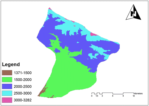
Figure 3. Land use map.
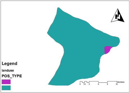
Figure 4. Climate classes.
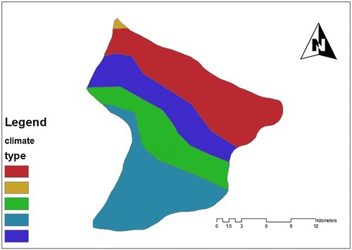
Figure 5. Sloping classes map.
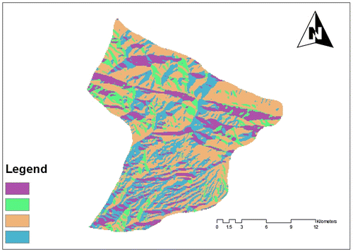
Figure 6. Soil classes.
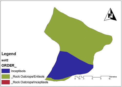
Figure 7. Slope classes map.
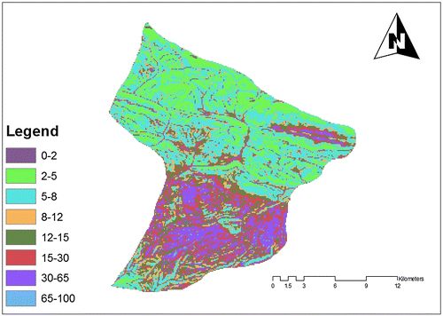
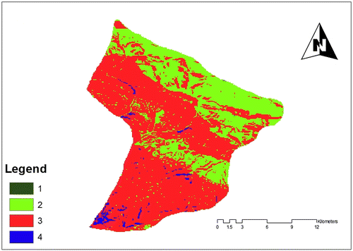
Figure 8. Map of agricultural power classes based on the method of regular average weighing.
4. Conclusion
In current research, we have used GIS for preparing, evaluating, classifying and overlapping layers. We have used six parameters for evaluating and classifying the power of the land. Finally, the areas that indicate the best potential for farming and other classes are identified. Totally, using this technique, we are able to evaluate the potential of the land for a variety of uses, but there are more precise techniques that we recommend, the multi-criteria decision-making techniques combined with fuzzy functions must be used in next researches.
Disclosure statement
No potential conflict of interest was reported by the authors.
Related Research Data
References
- Andrienko, G., Andrienko, N., & Jankowski, P. (2003). Building spatial decision support tools for individuals and groups. Journal of Decision Systems, 1(2), 193–208.
- Barredo, J., Benavides, A., Hervás, J., & van Westen, C.J. (2000). Comparing heuristic landslide hazard assessment techniques using GIS in the Tirajana basin, Gran Canaria Island, Spain. International Journal of Applied Earth Observation and Geoinformation, 2(1), 9–23.10.1016/S0303-2434(00)85022-9
- Beedasy, J., & Whyatt, D. (1999). Diverting the tourists: A spatial decision-support system for tourism planning on a developing island. International Journal of Applied Earth Observation and Geoinformation, 1(3–4), 163–174.10.1016/S0303-2434(99)85009-0
- Boroushaki, S., & Malczewski, J. (2008). Implementing an extension of the analytical hierarchy process using ordered weighted averaging operators with fuzzy quantifiers in ArcGIS. Computers & Geosciences, 34(4), 399–410.10.1016/j.cageo.2007.04.003
- Boroushaki, S., & Malczewski, J. (2010). Using the fuzzy majority approach for GIS-based multicriteria group decision-making. Computers & Geosciences, 36(3), 302–312.10.1016/j.cageo.2009.05.011
- Calijuri, M.L., Marques, E.T., Lorentz, J.F., Azevedo, R.F., & Carvalho, C.A. (2004). Multi-criteria analysis for the identification of waste disposal areas. Geotechnical and Geological Engineering, 22(2), 299–312.10.1023/B:GEGE.0000018358.82899.ca
- Collins, M.G., Steiner, F.R., & Rushman, M.J. (2001). Land-use suitability analysis in the United States: Historical development and promising technological achievements. Environmental Management, 28(5), 611–621.10.1007/s002670010247
- Dai, F.C., Lee, C.F., & Zhang, X.H. (2001). GIS-based geo-environmental evaluation for urban land-use planning: A case study. Engineering Geology, 61(4), 257–271.10.1016/S0013-7952(01)00028-X
- Joerin, F., Thériault, M., & Musy, A. (2001). Using GIS and outranking multicriteria analysis for land-use suitability assessment. International Journal of Geographical Information Science, 15(2), 153–174.10.1080/13658810051030487
- Jankowski, P., Andrienko, N., & Andrienko, G. (2001). Map-centred exploratory approach to multiple criteria spatial decision making. International Journal of Geographical Information Science, 15(2), 101–127.10.1080/13658810010005525
- Heywood, I., Oliver, J., & Tomlinson, S. (1995). Building an exploratory multi-criteria modelling environment for spatial decision support. Innovations in GIS, 2, 127–136.
- Karamiyan, R., Onaq, M., & Payamati, K. (2008). Water management of kouhdasht of lorestan using territorial planning. Journal of Agricultural Science and Natural Resources, 15(2), 183–193.
- Leopold, L.B. (1968). Hydrology for urban land planning: A guidebook on the hydrologic effects of urban land use. Washington, DC: US Geological Survey.
- Makropoulos, C.K., Butler, D., & Maksimovic, C. (2003). Fuzzy logic spatial decision support system for urban water management. Journal of Water Resources Planning and Management, 129(1), 69–77.10.1061/(ASCE)0733-9496(2003)129:1(69)
- Murphy, B.W. (2004). A revised land and soil capability classification for New South Wales. 13t International Soil Conservation Organization Conference-Brisbane.
- Tavakkol, M.S. (1997). The necessity of environmental assessment of land in physical development plans. Journal of Environmental studies, University of Tehran, 18(18), 61–74.
- Van Beek, E. (2009). Managing water under current climate variability. In F. Ludwig, P. Kabat, H. van Schaik, & M. Micheal van der valk (Eds.), Climate Change Adaptation in the Water Sector (pp. 51–77). London: Earthscan.
- Yager, R.R. (1988). On ordered weighted averaging aggregation operators in multicriteria decisionmaking. IEEE Transactions on Systems, Man, and Cybernetics, 18(1), 183–190.10.1109/21.87068