
Abstract
Recently, the remote sensing technologies have been used increasingly in various domains in order to explain or detect different phenomena in a rapid manner and covering large areas. This study aims to use Landsat 8 Oli imagery product to elaborate a map of soil salinity in the north-east part of Tadla plain, by implication of spectral reflectance and electrical conductivity (EC) measured in the laboratory. Based on salinity Index (SI), the Normalized Differential Salinity Index (NDSI), and Landsat bands, we carried out a statistical study via the JMP13 software to determine the most correlated bands with EC measured. The obtained results were very satisfactory with an R2 = 71.3% and root mean square error (RMSE) of 0.084. The elaborated map showed that the salinity is high near Oum Er Rbia River and the two cities of Beni-Mellal and Ouled Yaich, which is due to saline waters of Oum Er Rbia River and Béni-Moussa-East (Dir) groundwater used for irrigation. These results signify that the combination of remote sensing and laboratory EC measurements would be a suitable method for predicting soil salinity.
1. Introduction
Soil salinization is the accumulation of salt in soils, which is considered as an ecological problem that is often attributed to natural influences (80% in salinized lands), rather than anthropogenic activities. The high soil salinity or “salt-affected soils” affecting, in particular, the arid and semi-arid regions, contribute to the degradation of soil quality (Abrol, Yadav, & Massoud, Citation1988), and consequently constitutes a real threat to global food security. Furthermore, the Food and Agriculture Organization (Food & Agriculture Organization of the UN, Citation1989) indicates that in 227 million hectares of irrigated lands in the world, 20% are salt-affected. This salt-affected soil is increasing day after day to more than 30% in countries such as Egypt, Iran, and Argentina (Ghassemi, Jakeman, & Nix, Citation1995). This situation was similar in Morocco, where 5% of agricultural soils are affected by salinization in different degrees (Antipolis, Citation2003), reducing thus their productivity. Assessing the spatial distribution of salinity became, therefore, so important to appropriately manage and to protect the soils for agriculture purpose.
In recent decades, with the progress of remote sensing technologies, the prediction of soil salinity and mapping its spatial distribution in large-scales are becoming more important and easy. This prediction helps to prevent and minimize the salinity phenomena (Zhang, Wang, & Wang, Citation2002). The new remote sensing technologies become a powerful method to provide global and rich information on the spatiotemporal evolution of surface soil without any direct contact. This ability has been demonstrated in some studies, such as in Thailand by Shrestha (Citation2006), Mehrjardi, Mahmoodi, Taze, and Sahebjalal (Citation2008), and Bouaziz, Matschullat, and Gloaguen (Citation2011). Shrestha (Citation2006) conducted an assessment of soil salinity in north-east Thailand using soil properties and remote sensing, and developed different salinity prediction models containing the spectral variables, and including the Normalized Difference Vegetation Index (NDVI), Normalized Difference Salinity Index (NDSI), eight original bands of Landsat ETM+, and soil properties. The results obtained indicated that near-infrared (band 4) and mid-infrared (band 7) had the highest correlation with the measured electrical conductivity (EC). Otherwise, Mehrjardi et al. (Citation2008), working on an assessment of soil salinity map in Yazd-Ardakan Plain, has shown that among the Landsat ETM + bands the third one (red band) had the highest correlation with EC measured. Bouaziz et al. (Citation2011) has demonstrated by conducting research on soil salinity from a semi-arid climate in North-east Brazil that the incorporation of the Salinity Index (SI2) with near-infrared (NIR) (band 3) into a statistical model allowed to gain a great insight into the spatial detection of the spread of soil salinity. Tajgardan, Shataee, and Ayoubi (Citation2007) evaluated the spatial distribution of soil salinity North of Ag ghala, Golestan Province (Iran) by combining remote sensing and field EC measurement, and demonstrated that the use of ASTER sensor (Advanced Space borne Thermal Emission and Reflection Radiometer) can be used to elaborate a suitable regression model to predict soil salinity. The common between all previous studies is that they apply statistical methods as Principal Components Analysis (PCA) techniques and regression analysis. This combination has enabled them to predict and map soil salinity in their regions.
The current soil salinity problem is related to time and space, for which traditional methods (field investigation and laboratory analysis) are insufficient to monitor this phenomenon. The aim of this research article is to identify the saline areas in the north-east part of the Tadla plain using the new imagery techniques of Landsat Oli 8 with a spatial resolution of 30 m.
2. Study area
The study area is located in the north-east area of Tadla plain, which extends over an estimated area of 3,600 km2, between the High Atlas in the south and the Phosphates’ Plateau in the north (Figure ). The geological formations are mainly composed of limestone, marls, and sandstone. They are aged from Palaeozoic to Quaternary. Concerning the altitude, it varies from 400 m to 700 m with high peaks located close to the Atlas Piedmont. The annual temperatures range from 38 to 40 °C in summer and from 3 to 4 °C in winter. The average rain fall is 259 mm/y in the plain while 456 mm/y in mountain. It’s characterized by a Mediterranean climate with a dominance of semi-arid weather by a dry season from April to October and a rainy season from November to March.
The Tadla plain is one of the main agricultural zones in Morocco. This is owing to suitable soil conditions, favourable climate, and abundant underground and surface water resources. Hence, agriculture is the first socio-economic activity in the region (Barakat, Ennaji, El Jazouli, Amediaz, & Touhami, Citation2017). Cropping is based on cereals, forages, orchards (olive and citrus fruit trees), sugar beet and cotton, and vegetables. However, due to the agricultural intensification and to the water stress that the region is having in the last decades, irrigation and excessive inputs are required for intensive crop production. Such human activities are responsible for increasing the salt in the soil and for degradation of water resource quality, as reported in the scientific literature in some other areas of the Tadla plain (Barakat, El Baghdadi, Rais, Aghezzaf, & Slassi, Citation2016; Barbouchi et al., Citation2015; Hammoumi, Sinan, Lekhlif, & Lakhdar, Citation2013; Lahlou, Ajerame, Bogaert, & Bousetta, Citation2013; Lhissoui, El Harti, & Chokmani, Citation2014). Such investigation was not realized in our study area; hence the need to assess and map soil salinity in this area is becoming a wide necessity.
3. Materials and methods
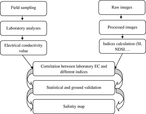
The methodology adopted in the present work began with a field campaign to collect representative soil samples spread throughout the study area. These samples were analysed by the saturated paste method to determine the electrical conductivity. Simultaneously, Landsat Oli8 images with the same time as our field campaign were used to calculate the various standard indices giving information about soil salinity. Afterwards, a statistical correlation between the electrical conductivity data and the computed spectral indices was made. Figure summarized the steps that we have followed to map the soil salinity in the study area.
Figure 2. Flowchart of the methodology used in the study.
3.1. Sampling and analysis
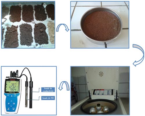
Soil samples were collected during March month 2015, from 97 sites scattered in a way to cover the entire north-east part of the Tadla plain. The exact coordinate of each composite sample was recorded using a global positioning system (GPS) with an accuracy of ±5 m (Figure ). The samples were dried in open air and sieved to 2 mm, and the fraction less than 2 mm was used to measure the electrical conductivity (EC) of the soil with a conductivity metre. To measure the ECe that is the electrical conductivity of a saturated soil-water extract, the water is removed from a just-saturated soil sample by a centrifuge or vacuum pump, and ECe of the water extract is measured. EC measurement by the saturated paste method is the preferred method to estimate soil salinity (Figure ).
Figure 1. Study area and sampling points.
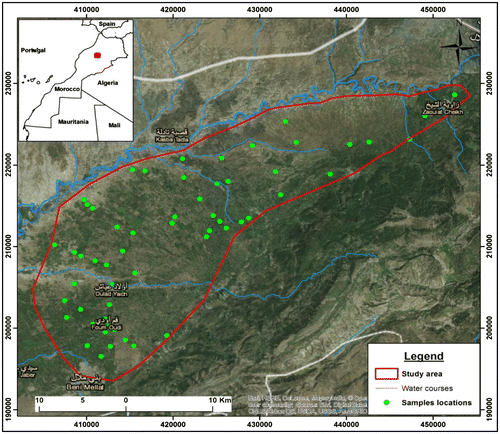
Figure 3. Procedure for measuring the electric conductivity.
3.2. Satellite data acquisition and processing
Free satellite images became widely used in several domains that require cartographic information. Satellite imagery data help to investigate the large area with low cost and time consuming. The remote sensing data selected in this study are captured by the Landsat sensor launched on 11 February 2013, which consists of two science instruments, the Operational Land Imager (OLI) and the Thermal Infrared Sensor (TIRS). These two sensors provide seasonal coverage of the global landmass at a spatial resolution of 30 m (visible, NIR, SWIR), 100 m (thermal), and 15 m (panchromatic). The wavelength and the use of all bands in Landsat 8 sonar are given in Table .
Table 1. Wavelengths of all bands in Landsat 8 and their uses.
The satellite image used in this study was acquired on 1 March 2015, simultaneously with soil sampling dates. This image was corrected atmospherically using the Dark Object Subtraction (DOS) model, which is a radiative transfer model that corrects the raw image and takes into account the state of the atmosphere at the acquisition date (Dial, Bowen, Gerlach, Grodecki, & Oleszczuk, Citation2003). All the remote sensing processing was performed using ENVI (Environment for Visualizing Images) software. Producing the soil salinity maps was carried out using ArcGIS 10.2.
3.3. Data analysis and model generation and selection
The data processing step consisted to separate the Landsat sensor bands individually. Then, some spectral soil salinity indices were tested and computed for assessing and enhancing the variation in surface soil salinity. Out of all indices tested, the SI (Salinity Index) (Equation Equation1(1) ), which has been proposed by Tripathi, Rai, and Dwivedi (Citation1997), and the NDSI index (normalized salinity index) (Equation Equation2
(2) ) by Aldakheel, Elprince, and Al-Hosaini (Citation2005) are the wildly used to create an enhanced images for soil salinity due to their very highly significant correlation with EC.
(1)
(2)
After computation of SI and NDSI index, and extraction of Landsat bands, an extraction has been done into the field sampling points corresponding values in all Landsat bands and two indices created. The values extracted from the different bands are then used to determine their correlation with the results obtained in the electrical conductivity measured in the laboratory.
In order to determine the band’s ration in our model, a stepwise regression method was performed to generate several suggestion models with different components characterized. These models are statistically evaluated based on their estimated error and correlation.
The performance and choice of the developed linear regression models that met the selection criteria were quantified using the test subset to ensure the use of the different data-sets and not only a particular set. The two quantitative criteria, a coefficient of determination (R2) and a root mean square error (RMSE) were calculated based on Equations (Equation3(3) ) and (Equation4
(4) ) for evaluating the relationship between soil EC measured and EC predicted from satellite images index.
(3)
(4)
With xi and yi are the measured and predicted values, respectively; and
represent, respectively, the means of the measured and predicted values; n is the number of samples.
The values of R2 indicate the strength of the statistical linear relationship between the measured and predicted values of soil salinity, and the mean root means square error (RMSE) indicates absolute estimation errors.
4. Results and discussion
The results obtained using stepwise regression analysis allowed us to determine the most correlated and uncorrelated bands with EC measured in the laboratory, then eliminate and select these able bands to be used during the development of our salinity Model. From these results, only the NDSI index, B4 and B1 bands were selected for our model with their different integration coefficients. The results obtained from the stepwise regression are summarized in Table .
Table 2. Results obtained from the stepwise regression.
According to several research studies (Eldeiry & Garcia, Citation2008, Citation2010; Hick & Russell, Citation1990; Howari, Citation2003; McLaughlin, Palmer, Tiller, Beech, & Smart, Citation1994; Metternicht & Zinck, Citation2003; Tripathi et al., Citation1997), the model equation is determined by multiplying the integration coefficients of each band into the band pixel values itself, then adding a model constant. Equation (Equation5(5) ) is our model equation that can describe the most variation of EC:
(5)
with the values 8.42, 2.11, and .16 are the integration coefficients of every band, and .31 is the elaborate model constant.
This elaborate equation has been integrated into a satellite image processing software, which allows us to develop a new salinity map for the study area. This soil salinity map showed a variable soil salinity distribution varying from .11 to 2.86 ds/cm (Figure ).
Figure 4. Soil salinity map.
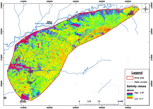
According to the produced soil salinity map (Figure ), the salinity is high in the north part of the study area, in proximity of the Oum Er Rbia River. Such salinity could be attributed to the use of the river saline water of Oum Er Rbia that is used in irrigation, and subsequently, affected agricultural soil by salinization (Faouzi & Larabi, Citation2001). Compared to the Piedmont area, this zone presented a high rate of salinity in the study area. The increased salinity near the two cities of Ouled Yaich and Beni-Mellal could be linked into irrigation by groundwater originating from Béni-Moussa-East (Dir) water table, which contains salinity between 700 and 1000 mg/l. These values are classified of high salinity concentrations according to Moroccan standards (Bellouti et al., Citation2002).
The resulting model from the R2 and RMSE parameters showed an increase in prediction power (R2 = .71) of predicting soil electrical conductivity and mapping the spatial variability of soil salinity in the study area, compared to similar case studies, i.e. that carried out by Fallah Shamsi, Zare, and Abtahi (Citation2013) where R2 = .39, and recently that conducted by Allbed, Kumar, and Sinha (Citation2014) showed R2 value of .65, which have been developed using different spatial resolution satellite images, this is partly due to the high spatial resolution of the Landsat 8 Oli images. We precise that the prediction of soil salinity based on the Landsat 8 Oli images offers better results than these based on moderate resolution images. It should be taken into account that spatial resolution is one of the important factors to deduce the soil salinity. In order to validate and verify the accuracy of the elaborate model results, a field trip was made on 1 May 2015 to take seven arbitrary samples in the study area, and compare their results with those obtained from our elaborate model. Table showed the values obtained for these seven samples and their equivalent in the elaborated model.
Table 3. Validation of the elaborated model using other samples.
From the validation points, we can say that our model gives results with ± .016 ds/cm, which means that this model can be very well used to give an estimation of the salinity at a large surface scale in a very fast and reliable manner.
5. Conclusion
Mapping and monitoring affected soils are a difficult study because salinization is a dynamic process. Yet, this study was conducted with the aim to assess the spatial soil salinity in the north-east part of Tadla plain because of its impacts on soil, water resource quality, and crop production. Remote sensing has been used for its synoptic coverage and the sensitivity of the electromagnetic signal to surface soil parameters. The OLI-SI and NDSI indices were evaluated by carrying out a series of regression analysis. The correlation between measured soil salinity and terrain OLI-SI and NDSI indices showed significant correlation with R2 of about 71.3%. This study, thus, demonstrated that the use of the remote sensing approach and image enhancement techniques are satisfactory for the detection and mapping of soil salinity, with a lower cost compared to other conventional approaches. Thus, this approach can be used by decision-makers to develop effective programmes to reduce or prevent future increases in soil salinity.
Disclosure statement
No potential conflict of interest was reported by the authors.
Funding
This work was supported by Sultan My Slimane University.
Related Research Data
References
- Abrol, I. P., Yadav, J. S. P., & Massoud, F. I. (1988). Salt-affected soils and their management. Rome: FAO.
- Aldakheel, Y. Y., Elprince, A. M., & Al-Hosaini, A. I. (2005). Mapping of salt-affected soils of irrigated lands in arid regions using remote sensing and GIS. In Proceedings of 2nd international conference on recent advances in space technologies, 2005 (RAST 2005) (pp. 467–472). IEEE. Retrieved from http://ieeexplore.ieee.org/xpls/abs_all.jsp?arnumber=1512614
- Allbed, A., Kumar, L., & Sinha, P. (2014). Mapping and modelling spatial variation in soil salinity in the Al Hassa Oasis based on remote sensing indicators and regression techniques. Remote Sensing, 6(12), 1137–1157.10.3390/rs6021137
- Antipolis, S. (2003). Les menaces sur les sols dans les pays mediterraneens. Plan Bleu, 80.
- Barakat, A., El Baghdadi, M., Rais, J., Aghezzaf, B., & Slassi, M. (2016). Assessment of spatial and seasonal water quality variation of Oum Er Rbia River (Morocco) using multivariate statistical techniques. International Soil and Water Conservation Research, 4(4), 284–292.10.1016/j.iswcr.2016.11.002
- Barakat, A., Ennaji, W., El Jazouli, A., Amediaz, R., & Touhami, F. (2017). Multivariate analysis and GIS-based soil suitability diagnosis for sustainable intensive agriculture in Beni-Moussa irrigated subperimeter (Tadla plain, Morocco). Modeling Earth Systems and Environment, 3(1), 3.10.1007/s40808-017-0272-5
- Barbouchi, M., Abdelfattah, R., Chokmani, K., Aissa, N. B., Lhissou, R., & El Harti, A. (2015). Soil Salinity characterization using polarimetric InSAR coherence: Case studies in Tunisia and Morocco. IEEE Journal of Selected Topics in Applied Earth Observations and Remote Sensing, 8(8), 3823–3832.10.1109/JSTARS.2014.2333535
- Bellouti, A., Cherkaoui, F., Benhida, M., Debbarh, A., Soudi, B., & Badraoui, M. (2002). Mise en place d’un système de suivi et de surveillance de la qualité des eaux souterraines et des sols dans le périmètre irrigué du Tadla, au Maroc. In Atelier du PCSI (Programme Commun Systèmes Irrigués) sur une Maîtrise des Impacts Environnementaux de l’Irrigation (11 p.). Cirad-IRD-Cemagref. Retrieved from http://hal.cirad.fr/cirad-00180737/
- Bouaziz, M., Matschullat, J., & Gloaguen, R. (2011). Improved remote sensing detection of soil salinity from a semi-arid climate in Northeast Brazil. Comptes Rendus Geoscience, 343(11–12), 795–803.10.1016/j.crte.2011.09.003
- Dial, G., Bowen, H., Gerlach, F., Grodecki, J., & Oleszczuk, R. (2003). IKONOS satellite, imagery, and products. Remote Sensing of Environment, 88(1-2), 23–36.10.1016/j.rse.2003.08.014
- Eldeiry, A. A., & Garcia, L. A. (2008). Detecting soil salinity in Alfalfa fields using spatial modeling and remote sensing. Soil Science Society of America Journal, 72(1), 201–211.10.2136/sssaj2007.0013
- Eldeiry, A. A., & Garcia, L. A. (2010). Comparison of ordinary kriging, regression Kriging, and Cokriging techniques to estimate soil salinity using LANDSAT images. Journal of Irrigation and Drainage Engineering, 136(6), 355–364.10.1061/(ASCE)IR.1943-4774.0000208
- Fallah Shamsi, S. R., Zare, S., & Abtahi, S. A. (2013). Soil salinity characteristics using moderate resolution imaging spectroradiometer (MODIS) images and statistical analysis. Archives of Agronomy and Soil Science, 59(4), 471–489.10.1080/03650340.2011.646996
- Faouzi, M., & Larabi, A. (2001). Problématique de la remontée, de la salinité et de la pollution par les nitrates des eaux de la nappe phréatique des Beni-Amir (Tadla, Maroc). Ingénieries-EAT, (27), 23.
- Food & Agriculture Organization of the UN. (1989). The state of food and agriculture (Vol. 37). Rome: Author.
- Ghassemi, F., Jakeman, A. J., & Nix, H. A. (1995). Salinisation of land and water resources: Human causes, extent, management and case studies. CAB international. Retrieved from https://www.cabdirect.org/cabdirect/abstract/19976767459
- Hammoumi, N. E., Sinan, M., Lekhlif, B., & Lakhdar, M. (2013). Use of multivariate statistical and geographic information system (GIS)-based approach to evaluate ground water quality in the irrigated plain of Tadla (Morocco). International Journal of Water Resources and Environmental Engineering, 5(2), 77–93.
- Hick, P. T., & Russell, W. G. R. (1990). Some spectral considerations for remote sensing of soil salinity. Australian Journal of Soil Research, 28(3), 417–431.10.1071/SR9900417
- Howari, F. M. (2003). The use of remote sensing data to extract information from agricultural land with emphasis on soil salinity. Australian Journal of Soil Research, 41(7), 1243–1253.10.1071/SR03033
- Lahlou, M., Ajerame, M. M., Bogaert, P., & Bousetta, B. (2013). Spatiotemporal variability and mapping of groundwater salinity in Tadla: Geostatistical approach. In Developments in soil salinity assessment and reclamation (pp. 167–182). Springer. Retrieved from http://link.springer.com/10.1007/978-94-007-5684-7_1110.1007/978-94-007-5684-7
- Lhissoui, R., El Harti, A., & Chokmani, K. (2014). Mapping soil salinity in irrigated land using optical remote sensing data. Eurasian Journal of Soil Science, 3(2), 82–88.10.18393/ejss.84540
- McLaughlin, M. J., Palmer, L. T., Tiller, K. G., Beech, T. A., & Smart, M. K. (1994). Increased soil salinity causes elevated cadmium concentrations in field-grown potato tubers. Journal of Environment Quality, 23(5), 1013–1018.10.2134/jeq1994.00472425002300050023x
- Mehrjardi, R. T., Mahmoodi, S. H., Taze, M., & Sahebjalal, E. (2008). Accuracy assessment of soil salinity map in Yazd-Ardakan Plain, Central Iran, based on Landsat ETM+ imagery. Am.-Eurasian. J. Agric. Environ. Sci, 3, 708–712.
- Metternicht, G. I., & Zinck, J. A. (2003). Remote sensing of soil salinity: Potentials and constraints. Remote Sensing of Environment, 85(1), 1–20.10.1016/S0034-4257(02)00188-8
- Shrestha, R. P. (2006). Relating soil electrical conductivity to remote sensing and other soil properties for assessing soil salinity in northeast Thailand. Land Degradation & Development, 17(6), 677–689.10.1002/(ISSN)1099-145X
- Tajgardan, T., Shataee, S., & Ayoubi, S. (2007). In spatial prediction of soil salinity in the arid zones using ASTER data, case study: North of Ag Ghala, Golestan Province, Iran. In Proceedings of Asian Conference on Remote Sensing (ACRS), Kuala Lumpur, Malaysia (Vol. 1216). Retrieved from https://www.researchgate.net/profile/Shaban_Shataee/publication/228878672_Spatial_prediction_of_soil_salinity_in_the_arid_zones_using_ASTER_data_Case_study_North_of_Ag_ghala_Golestan_Province_Iran/links/546e2b750cf2bc99c2154970.pdf
- Tripathi, N. K., Rai, B. K., & Dwivedi, P. (1997). Spatial modeling of soil alkalinity in GIS environment using IRS data. The 18th Asian Conference on Remote Sensing, Kualalampur.
- Zhang, N., Wang, M., & Wang, N. (2002). Precision agriculture—A worldwide overview. Computers and Electronics in Agriculture, 36(2–3), 113–132.10.1016/S0168-1699(02)00096-0