
Abstract
Despite the semi-arid to arid nature of its climate, Morocco is exposed, like all the Mediterranean countries to inundations, which can be very damaging for public and private infrastructure, and cause many victims. On Monday 10 August 2015, one of Oued El Abid tributary raised in a remarkable way, causing five deaths and serious material damage in Iminwargue village (Azilal province). This study comes to assess the impact of land use/cover variation in the multiplication of floods frequency via the hydraulic simulations. For this purpose, relying on land use/cover variation from 1987 to 2017, flow and precipitation database, we made a hydraulic simulation of the 2015 event and the 100 years recurrence inundation. As results, the land use/cover decrease is always followed by an increase in flows peak even that all recorded precipitations are more or less similar. The case study hundred years inundation prediction shows a 5.03 m increase in the river and all population near banks, agricultural land and other useful infrastructure such as roads and bridges are invaded. These results show that more catastrophic events could be reproduced and oblige the decision makers in Oued El Abid watershed to be aware of the critical situation.
1. Introduction
In the last decades many Inundations have occurred in the world and claiming more than 20,000 lives per year and adversely affecting about 75 million people world-wide, mostly through homelessness (Sarhadi, Soltani, & Modarres, Citation2012). This phenomenon have been aggravated, in several cases, by the land cover use changes especially in the intense urbanisation of inundation prone areas and deforestation (Alexander et al., Citation2006; Brath, Montanari, & Moretti, Citation2006; Bronstert, Citation2003; Esteban-Parra, Rodrigo, & Castro-Diez, Citation1998; Meehl et al., Citation2000; Ntegeka & Willems, Citation2008; Oudin, Andréassian, Perrin, Michel, & Le Moine, Citation2008).
Projected future climate change and extreme weather events are expected to get worse than the actual situation (Pachauri et al., Citation2014). As the severity and inundations frequency considerably increase, the human societies realized that the traditional paradigm of protecting themselves are not a sufficient option for the future (Kuks & Kissling-Näf, Citation2004; Pahl-Wostl et al., Citation2013; Smits, Nienhuis, & Leuven, Citation2000). Instead, the practitioners agree that inundation management should be based on an integrated risk management approach (Sevruk, Ondrás, & Chvíla, Citation2009). Identifying prone areas can therefore be one of the key solutions in inundation mitigation (Achleitner et al., Citation2016). Predicting susceptible inundation plains and keys factors of its development can help authorities in planning management strategies for inundation mitigation (Cundill & Fabricius, Citation2010; Sanders, Citation2007). Hydro-meteorological catastrophes cannot be totally evaded, but the impacts and triggering factors can be handled by developing effective risk reduction strategies through application of latest geospatial tools and decision support systems (Khattak et al., Citation2016). The application of full modelling steps from rainfall-runoff to test different scenarios of land use variation is a paramount necessity tool to gain spatial coherence when estimating losses (Al-Zahrani, Al-Areeq, & Sharif, Citation2016; Booij, Citation2005; De Bruijn, Diermanse, & Beckers, Citation2014; Gems, Achleitner, Huttenlau, Thieken, & Aufleger, Citation2009; Golshan, Jahanshahi, & Afzali, Citation2016).
In Morocco, the frequency and intensity of inundations in recent decades have grown in a remarkable way, especially in Oued El Abid watershed, due to heavy rain intensity, land use variation and rugged topography characterize by high slope.
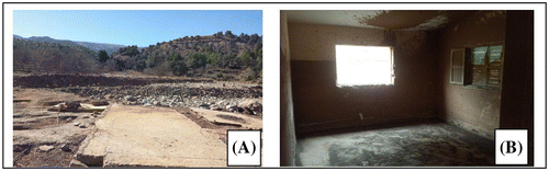
In light of this repetitive catastrophic event, the present work aims to propose a methodology for the land use variation effect on the hydrological response in the upper part of Oued EL Abid watershed, by developing a case study that refers to Alfet River basin (Oued El Abid tributary). This sub-basin in 10 August 2015 has experienced one of the most violent event in which the water level raised by 10 m and caused the death of 5 peoples, the destruction of 5 houses and the road No. 302 linking the two villages Tillouguite and Aminouak (Figure ).
Figure 1. Field photographs (A) destroyed house (B) flood lines inside a house.
2. The study area
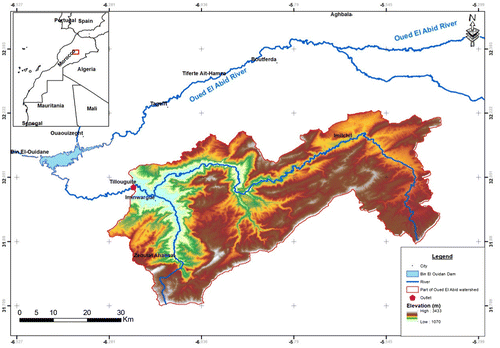
The upper part of Oued El Abid watershed is located in the centre of northern part in Morocco, in Khenifra-Beni Mellal region and Azilal province. It extends over an area of 7686 km2. The study area is characterized by a semi-arid climate, and concentration of rainfall in autumn and winter, high evaporation and high average temperatures with high monthly and daily amplitude. The minimum temperature is −5 °C recorded in January while the maximum is 34.9 °C in August.
The case study (Iminwargue village), is located in a distance of 30 km from Azilal City, in Alfet River (Oued El Abid tributary). The Alfet River watershed originates in 2527 m at Morocco High Atlas and extends over an area of 2.04 km2 in the middle of Oued El Abid watershed (Figure ).
Figure 2. Study area location. Source: Author.
3. Materials and methods
Our work methodology has been initiated by studying the land use variation at Oued El Abid watershed during a period of 1987–2017, then the effects of this variation on the hydrological response in the study area watercourses. The obtained results in this analysis are used later in a case study of Tillouguite village to indicate the inundation event extension, and then estimating the damages that could be caused in the future inundations events via the hydraulic simulation.
The topographic maps and last inundations damage statistics were given by the Authority of Tillouguite. While hydrological and climatic data provided by the Meteorological Department in the Oum Er-Rbia Hydraulic Basin Agency of Beni Mellal city.
3.1. Analysis of the land use/cover variation in Oued El Abid watershed
In recent decades, considerable changes in land use and vegetation cover have occurred in the different regions of Morocco. As a quite general rule, from the early 1970s meadows and pastures characterized the most mountainous region at the time, decreased as deforestation and urbanization that led to the abandonment of cattle rearing. As a result, these mountainous areas have been left fallow and unproductive. A similar behaviour occurred in the considered basin of Oued El Abid.
To quantify the Land use /cover variation rate in Oued El Abid watershed and its effects on the hydrological response. Satellite images from the Landsat TM5 and Oli 8 sensors were used to monitor the annual rate evolution since October 1987 until 2017.
In this study, we used satellite images captured in October month of every year to homogenize the land use /cover obtained results, to avoid intense cloud rate, and get a better results from the vegetation cover.
3.2. Hydrological study
Precipitation and flow data adopted in our study are those of Tillouguite station, located in the south-east of Oued El Abid watershed. The Tillouguite information is summarized in Table .
Table 1. Tillouguite station’ description.
The statistical adjustment was carried out through HYfran software to predicted precipitation and flow peak in different returns periods (Alzate, Guyumus, Quijano, & Díaz-Granados, Citation2016; Sami, Hadda, & Mahdi, Citation2016). The chosen law should take into consideration a lowest AIC and BIC coefficients and greatest posterior probability criteria (Banner & Higgs, Citation2017).
To estimate the peak flow in ungauged rivers (as Alfet River), deterministic and regionalization formulas are used. and the following approaches are adopted in this estimation (D’Ambrosio, De Girolamo, Barca, Ielpo, & Rulli, Citation2016):
| • | Empirical approach: when there is no rainfall or hydrometric data or the recorded data are not sufficient, then the flow peak prediction is based on the geometric parameters (length of the river, average slope, vegetation cover, rainfall annual) and using many formulas as Mallet-Gauthier, Hazan Lazarevic, Fuller II … | ||||
| • | Hydro meteorological approach: in which we employ close climatic station data to estimate flow peak in the watercourse. | ||||
3.3. Hydraulic study
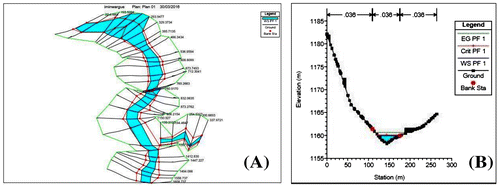
The hydraulic simulation has been performed in one-dimensional (1D) software to define the inundation spread. The required data include cross-sections geometry, Manning’s n values (land use/cover nature), flow peak and boundary conditions.
The geometric data has been provided by Tillouguite municipality and covers urbanized of 2.1 km2 in Iminwargue centre as contour map in Auto CAD (.dwg file). Thirty-one cross-sections at various important locations on the river have been used.
The one-dimensional (1D) software, such as Mike 11, ISIS or HEC-RAS, are based on water Equations variations, and still form the majority of traditional numerical hydraulic models used in practical river engineering. It might be explained not only by the fact that 1D models are (in comparison to higher dimensional models) simpler and required a minimum input data, but also because the basic concepts and programs have already been around for several decades and improved its accuracy (Goodell & Warren, Citation2006; Pappenberger, Beven, Horritt, & Blazkova, Citation2005).
4. Results
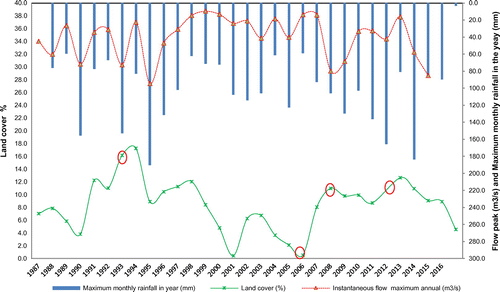
The land use /cover variation is more or less variable in every year, we notice that since the year 1987 its generally varying between 9.9% and 44.4%, and most covered part in the study area is the lower one (Figure ). These results were superimposed with flow peak and maximum annual precipitations values (Figure ).
Figure 3. Land use/cover annual evolution since October 1987 to 2017. Source: Geographic information system (QGIS) Open source.
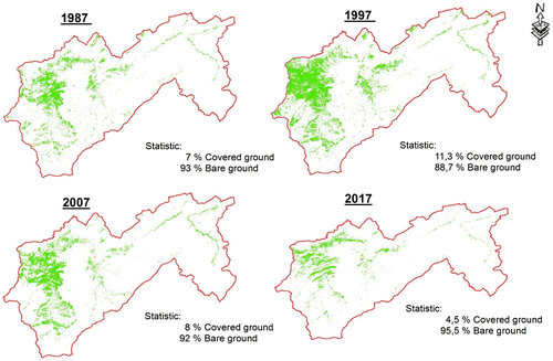
Figure 4. Land use /cover rate evolution according to instantaneous flow peak and maximum monthly rainfall per year since 1987.
The morphological characteristics (Table ) of the case study (Alfet catchment) are determined using GIS techniques.
Table 2. Alfet watershed general characteristics.
The precipitation adjustment showed (Figure and Table ) that Normal distribution law fits to our meteorological data. Table gives the results of this adjustment where the precipitation measurements distribution is represented in 99% confidence interval and AIC and BIC criteria are the lowest.
Figure 5. Monthly rainfall graphic representation according to Normal low.
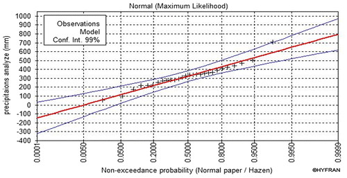
Table 3. Distributions low comparison criteria.
Table 4. Precipitation statistical adjustment results by normal low.
The case study flow peak calculation is made through various formulas for the ungauged river (Table ).
Table 5. Flow results according to different recurrences times.
The simulation results for the 100 year recurrence period (Table and Figure ) showed that flow regime is usually torrential, characterized by Froude numbers greater than unity (Fr > 1) in 78.1% of the simulated sections. The average speed varies between 0.36 m/s (Vmin) and 6.69 m/s (Vmax) while the average velocity (Vmean) is 3.53 m/s.
Table 6. Extract from the simulation table results.
Figure 6. (A) Flooding zones in 3D schema (B) water level in a cross section.
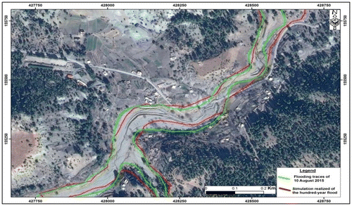
The inundation zones limits for the predicted 100 year and the 2015 events via the hydraulic simulation are represented in Google Earth image background (Figure ).
Figure 7. Inundation zones limits in a Google Earth background. Source: Author.
5. Discussion
By observing the Figure , it can be seen that during the 1994–2007 period, the study area undergone a very significant decrease in the land use /cover rate (0.4%), while the two periods of 1991–1994 and 2007–2013 have generally a fluctuation between 8.2 and 17.3%. From the year 2013, the Land use /cover began to deteriorate to a value of 4.5% in 2017. This degradation is generally followed by a very significant increase in the watershed flow peak until 94.7 m3/s. The land use /cover presence can play the role of braking flow peaks in the intense precipitations. A similar result was found by Zhang where he determined that land use/cover (vegetation rate) can import a significant influence in recorded flow peaks (Zhang, Zhang, Zhao, Rustomji, & Hairsine, Citation2008). In its low rate presence, the precipitation impact becomes very important in mountainous area, where the surface flow became major due to infiltration and stagnation lack (DeFries & Eshleman, Citation2004; Hundecha & Bárdossy, Citation2004; Matheussen, Kirschbaum, Goodman, O’Donnell, & Lettenmaier, Citation2000).
In 1993, 2006 and 2012 years, we have an exceptional cases, where the land use /cover rate is very important but the watershed hydrological response is entirely not normal (a significant flow peak). This difference could be due to satellite images used for land use/cover determination, which are collected during the October month of each year. And sometimes we can have intense precipitations and high flow peak before October. Thereafter, the cover is that of the previous year. By analysing land use/cover of 1993, 2006 and 2016 we can see that before those events it has a less rate cover compared to the event itself. These exceptional cases are generally obtained when the precipitation during the period between June and September is important.
With the same amount of precipitation, sometimes the hydrological response of the watershed is different, this can be explained by the influence of several parameters, not only the land use /cover rate. Several researchers have found that the watershed hydrological response is also influenced by precipitation intensity, slope and geology … (Lavabre, Torres, & Cernesson, Citation1993; Vicente-Serrano & López-Moreno, Citation2005). In our case, unfortunately we don’t have precipitation intensity data, for this reason the absolute explanation is hard to be done. But the important thing in our results is that flow peaks generally knows an increase when the land use /cover decrease.
Regarding the case study and prediction, the results found are estimates and statistical prediction. its validation remains difficult to complete and achieve (Horritt & Bates, Citation2002) to bring out, some researchers use recorded historical inundations events to compare its extents with the predicted results. This means that hydraulic simulation can give very exploitable results in terms of delimitation of the inundation zones but remain with a margin of error extremely small view that no one can validate them surely (Faghih, Mirzaei, Adamowski, Lee, & El-Shafie, Citation2017). This margin can be neglected in the majority of the cases, because this constraint can be avoided by adding more distance on the inundation zone boundaries to avoid any repercussion. In our case study, we used the August 10, 2015 inundation limits as one of the most destructive event, and we compare its results with the predicted 100 years recurrence inundation via the hydraulic simulation.
The 100 years inundation simulation results (Figure ) showed that the extents of predicted flood can touch many buildings on the right bank, the school near the right bank of the road, and invade almost the entire road that through the centre and contain an hydraulic structure (double box culverts) due to its insufficient capacity. These results provide a scientific basis for decision makers to choose a better way to protect people and their belongings. This protection can be achieved by the use of hydraulic protection structures or by protection of plant covers and implantation of new trees to reduce the process of flow peaks increase (Harada et al., Citation2015; Henderson, Citation1986; Khosru Shahi, Abrishami, Asghar, & Sheybani Zadeh, Citation2009; Yang, Wang, Voisin, & Copping, Citation2015; Zając, Solarz, & Bielański, Citation2006; Zelo, Shipman, & Brennan, Citation2000).
6. Conclusions
The obtained results during this study have shown that the evolution of the land use /cover has a very important impact on the watershed’s response and can increase inundation intensity. This result has been proven by the 2015 event analysis, which is due to land use/cover decrease followed by an increase in flow peak and subsequently the fatal damages. Predictions of precipitations, flow peaks and the 2013–2017 land use/cover degradation trend have shown that fatal events will be repeated over and over again if we do not have any intervention of decision-makers, in order to protect riparian and vegetation cover. The contribution of the hydraulic modelling techniques has made it possible to highlight the same conditions of the event of 2015 and to make a sort of prediction of possible future damages.
Disclosure statement
No potential conflict of interest was reported by the authors.
References
- Achleitner, S., Huttenlau, M., Winter, B., Reiss, J., Plörer, M., & Hofer, M. (2016). Temporal development of flood risk considering settlement dynamics and local flood protection measures on catchment scale: An Austrian case study. International Journal of River Basin Management, 14(3), 273–285. doi:10.1080/15715124.2016.1167061
- Alexander, L. V., Zhang, X., Peterson, T. C., Caesar, J., Gleason, B., Klein Tank, A. M. G., … Vazquez-Aguirre, J. L. (2006). Global observed changes in daily climate extremes of temperature and precipitation. Journal of Geophysical Research: Atmospheres, 111(D5), 1–22. doi:10.1029/2005JD006290.
- Al-Zahrani, M., Al-Areeq, A., & Sharif, H. (2016). Flood analysis using HEC-RAS model: A case study for Hafr Al-Batin, Saudi Arabia. In E3S Web of Conferences (Vol. 7, p. 04024). EDP Sciences. Retrieved from http://www.e3s-conferences.org/articles/e3sconf/abs/2016/02/e3sconf_flood2016_04024/e3sconf_flood2016_04024.html
- Alzate, S. J., Guyumus, D. E., Quijano, J. P., & Díaz-Granados, M. (2016). Two-dimensional hydraulic flood modelling in domains with multiple tributaries areas for risk analysis. In River Flow 2016 (pp. 1784–1792). CRC Press. Retrieved from http://www.crcnetbase.com/doi/pdfplus/10.1201/9781315644479-27910.1201/9781315644479
- Banner, K. M., & Higgs, M. D. (2017). Considerations for assessing model averaging of regression coefficients. Ecological Applications, 27(1), 78–93.10.1002/eap.2017.27.issue-1
- Booij, M. J. (2005). Impact of climate change on river flooding assessed with different spatial model resolutions. Journal of Hydrology, 303(1–4), 176–198. doi:10.1016/j.jhydrol.2004.07.013
- Brath, A., Montanari, A., & Moretti, G. (2006). Assessing the effect on flood frequency of land use change via hydrological simulation (with uncertainty). Journal of Hydrology, 324(1–4), 141–153. doi:10.1016/j.jhydrol.2005.10.001
- Bronstert, A. (2003). Floods and climate change: Interactions and impacts. Risk Analysis, 23(3), 545–557.10.1111/risk.2003.23.issue-3
- Cundill, G., & Fabricius, C. (2010). Monitoring the governance dimension of natural resource co-management. Ecology and Society, 15(1). Retrieved from http://www.ecologyandsociety.org/vol15/iss1/art15/main.html
- D’Ambrosio, E., De Girolamo, A. M., Barca, E., Ielpo, P., & Rulli, M. C. (2016). Characterising the hydrological regime of an ungauged temporary river system: A case study. Environmental Science and Pollution Research, 24(16), 13950–13966.
- De Bruijn, K. M., Diermanse, F. L. M., & Beckers, J. V. L. (2014). An advanced method for flood risk analysis in river deltas, applied to societal flood fatality risk in the Netherlands. Natural Hazards and Earth System Science, 14(10), 2767–2781.10.5194/nhess-14-2767-2014
- DeFries, R., & Eshleman, K. N. (2004). Land-use change and hydrologic processes: A major focus for the future. Hydrological Processes, 18(11), 2183–2186.10.1002/(ISSN)1099-1085
- Esteban-Parra, M. J., Rodrigo, F. S., & Castro-Diez, Y. (1998). Spatial and temporal patterns of precipitation in Spain for the period 1880–1992. International Journal of Climatology, 18(14), 1557–1574.10.1002/(ISSN)1097-0088
- Faghih, M., Mirzaei, M., Adamowski, J., Lee, J., & El-Shafie, A. (2017). Uncertainty estimation in flood inundation mapping: An application of non-parametric bootstrapping. River Research and Applications, 33(4), 611–619. doi: 10.1002/rra.3108
- Gems, B., Achleitner, S., Huttenlau, M., Thieken, A., & Aufleger, M. (2009). Flood control management for an alpine valley in Tyrol-an integrated hydrological-hydraulic approach. 33rd IAHR World Congress, Vancouver. Retrieved from https://www.researchgate.net/profile/Bernhard_Gems/publication/285393526_Flood_control_management_for_an_alpine_valley_in_Tyrol_-_an_integrated_hydrological-hydraulic_approach/links/5763171208ae192f513e3f0b.pdf
- Golshan, M., Jahanshahi, A., & Afzali, A. (2016). Flood hazard zoning using HEC-RAS in GIS environment and impact of manning roughness coefficient changes on flood zones in Semi-arid climate. Desert, 21(1), 24–34.
- Goodell, C., & Warren, C. (2006). Flood inundation mapping using HEC-RAS. In Obras Y Proyectos, (2nd ed., pp. 18–23).
- Harada, I., Hara, K., Park, J., Asanuma, I., Tomita, M., Hasegawa, D., & Short, K. (2015). Monitoring of rapid land cover changes in eastern Japan using Terra/MODIS data. ISPRS – International Archives of the Photogrammetry, Remote Sensing and Spatial Information Sciences, XL-7/W3(7), 403–408.10.5194/isprsarchives-XL-7-W3-403-2015
- Henderson, J. E. (1986). Environmental designs for streambank protection projects. Journal of the American Water Resources Association, 22(4), 549–558.10.1111/jawr.1986.22.issue-4
- Horritt, M. S., & Bates, P. D. (2002). Evaluation of 1D and 2D numerical models for predicting river flood inundation. Journal of Hydrology, 268(1–4), 87–99. doi:10.1016/S0022-1694(02)00121-X
- Hundecha, Y., & Bárdossy, A. (2004). Modeling of the effect of land use changes on the runoff generation of a river basin through parameter regionalization of a watershed model. Journal of Hydrology, 292(1–4), 281–295.10.1016/j.jhydrol.2004.01.002
- Khattak, M., Anwar, F., Sheraz, K., Saeed, T., Sharif, M., & Ahmed, A. (2016). Floodplain mapping using HEC-RAS and ArcGIS: A case study of Kabul River. Arabian Journal for Science & Engineering (Springer Science & Business Media BV), 41(4), 1375–1390.
- Khosru Shahi, M., Abrishami, T., Asghar, A., & Sheybani Zadeh, Z. (2009). Results of flood increasing and aggravation in Iran with emphasis vegetation cover effect in Khorasan-e_razavi Province (Iran). Reseach Institute of Forest and Rangeland, P189.
- Kuks, S., & Kissling-Näf, I. (2004). The evolution of national water regimes in Europe: Transitions in water rights and water policies (Vol. 40). Springer Science & Business Media. Retrieved from https://books.google.fr/books?hl=fr&lr=&id=96BdUGfamB8C&oi=fnd&pg=PR11&dq=Kuks+SMM+(2005)+The+evolution+of+national+water+regimes+in+Europe.+Transitions+in+water+rights+and+water+policies.+Paper+for+the+Conference+on+BSustainable+Water+Management:+Comparing+Perspectives+from+Australia,+Europe+and+the+United+States%5E,+15%E2%80%9316+Sept&ots=L_IWv2GtnQ&sig=nNM5ae2j_94l0SPCsuRFwfTPCjY
- Lavabre, J., Torres, D. S., & Cernesson, F. (1993). Changes in the hydrological response of a small Mediterranean basin a year after a wildfire. Journal of Hydrology, 142(1–4), 273–299.10.1016/0022-1694(93)90014-Z
- Matheussen, B., Kirschbaum, R. L., Goodman, I. A., O’Donnell, G. M., & Lettenmaier, D. P. (2000). Effects of land cover change on streamflow in the interior Columbia River Basin (USA and Canada). Hydrological Processes, 14(5), 867–885.10.1002/(ISSN)1099-1085
- Meehl, G. A., Zwiers, F., Evans, J., Knutson, T., Mearns, L., & Whetton, P. (2000). Trends in extreme weather and climate events: Issues related to modeling extremes in projections of future climate change. Bulletin of the American Meteorological Society, 81(3), 427–436.10.1175/1520-0477(2000)081<0427:TIEWAC>2.3.CO;2
- Ntegeka, V., & Willems, P. (2008). Trends and multidecadal oscillations in rainfall extremes, based on a more than 100-year time series of 10 min rainfall intensities at Uccle, Belgium. Water Resources Research, 44(7). W07402 (1–15). doi:10.1029/2007WR006471
- Oudin, L., Andréassian, V., Perrin, C., Michel, C., & Le Moine, N. (2008). Spatial proximity, physical similarity, regression and ungaged catchments: A comparison of regionalization approaches based on 913 French catchments. Water Resources Research, 44(3). W03413 (1–15). doi:10.1029/2007WR006240
- Pachauri, R. K., Allen, M. R., Barros, V. R., Broome, J., Cramer, W., Christ, R., … van Ypserle, J. P. (2014). Climate change 2014: Synthesis report. In Contribution of working groups I, II and III to the fifth assessment report of the intergovernmental panel on climate change (p. 151). R. Geneva, Switzerland: IPCC. ISBN: 978-92-9169-143-2.
- Pahl-Wostl, C., Arthington, A., Bogardi, J., Bunn, S. E.,Hoff, H., Lebel, L., ... Tsegai, D. (2013). Environmentalflows and water governance: Managing sustainable wateruses. Current Opinion in Environmental Sustainability, 5(3), 341–351. doi:10.1016/j.cosust.2013.06.009
- Pappenberger, F., Beven, K., Horritt, M., & Blazkova, S. (2005). Uncertainty in the calibration of effective roughness parameters in HEC-RAS using inundation and downstream level observations. Journal of Hydrology, 302(1–4), 46–69. doi:10.1016/j.jhydrol.2004.06.036
- Sami, G., Hadda, D., & Mahdi, K. (2016). Estimation and mapping of extreme rainfall in the catchment area of batna (Algeria). Annals of the University of Oradea, Geography Series/Analele Universitatii Din Oradea, Seria Geografie, 26(1). Retrieved from http://search.ebscohost.com/login.aspx?direct=true&profile=ehost&scope=site&authtype=crawler&jrnl=12211273&AN=117903293&h=dDwutstxcOkVFwDsNgEZQvSvX5Z8H9qrF3tSjG54i39SLSXZKcn5N6AMFBuFKAH%2FITqrxyFw6Yrgbrwg97SQgQ%3D%3D&crl=c
- Sanders, B. F. (2007). Evaluation of on-line DEMs for flood inundation modeling. Advances in Water Resources, 30(8), 1831–1843. doi:10.1016/j.advwatres.2007.02.005
- Sarhadi, A., Soltani, S., & Modarres, R. (2012). Probabilistic flood inundation mapping of ungauged rivers: Linking GIS techniques and frequency analysis. Journal of Hydrology, 458–459, 68–86. doi:10.1016/j.jhydrol.2012.06.039
- Sevruk, B., Ondrás, M., & Chvíla, B. (2009). The WMO precipitation measurement intercomparisons. Atmospheric Research, 92(3), 376–380.10.1016/j.atmosres.2009.01.016
- Smits, A. J. M., Nienhuis, P. H., & Leuven, R. S. E. W. (2000). New approaches to river management. Environmental Management and Health, 11(5), 474–475.10.1108/emh.2000.11.5.474.1
- Vicente-Serrano, S. M., & López-Moreno, J. I. (2005). Hydrological response to different time scales of climatological drought: An evaluation of the standardized precipitation index in a mountainous Mediterranean basin. Hydrology and Earth System Sciences, 9(5), 523–533.10.5194/hess-9-523-2005
- Yang, Z., Wang, T., Voisin, N., & Copping, A. (2015). Estuarine response to river flow and sea-level rise under future climate change and human development. Estuarine, Coastal and Shelf Science, 156, 19–30.10.1016/j.ecss.2014.08.015
- Zając, T., Solarz, W., & Bielański, W. (2006). Adaptive settlement in sedge warblers Acrocephalus schoenobaenus—focus on the scale of individuals. Acta Oecologica, 29(2), 123–134.10.1016/j.actao.2005.07.009
- Zelo, I., Shipman, H., & Brennan, J. (2000). Alternative bank protection methods for Puget Sound shorelines. Shorelands and Environmental Assistance Program, Washington Department of Ecology.
- Zhang, X., Zhang, L., Zhao, J., Rustomji, P., & Hairsine, P. (2008). Responses of streamflow to changes in climate and land use/cover in the Loess Plateau, China. Water Resources Research, 44(7), W00A07 (1–12). doi:10.1029/2007WR006711