
Abstract
In the present study an updated tectonic lineament database for Pachamalai hill, a resource-rich hill of central Tamil Nadu state of India has been generated and analysed. Digital Elevation Model generated from CARTOSAT-1 satellite data have been the data source. Lineaments extracted from eight different azimuth angles were compiled together towards the generation of the lineament database, which has been subsequently analysed for their number, length, density and spatial distribution using ArcGIS software. In addition, their orientations were analysed using Rockworks software. Of the 561 lineaments of the study area, about 90% are very short and short lineaments. The total length of the lineaments is 680 sq. km and their density ranges from 0 to 3.4 km/sq. km. The diversely oriented lineaments of the hill reflect the multiple deformation events that have affected the region through geologic time. In about 30% of the hill, the lineament density is high to very high which implies higher degree of deformation, fracturing, shearing and permeability of rocks besides higher soil erodibility and groundwater yield. These high to very high density areas render themselves unsuitable for the construction of dams and reservoirs as the possibility of water leakages into the subsurface, slope and dam failures and rate of sedimentation would be higher. Further, the analysis of the lineaments clearly underlines the need to extract lineaments from different azimuth angles instead of the widely adopted practice of mapping lineaments from single azimuth angle.
Keywords:
1. Introduction
The term lineament refers to mappable linear or curvilinear features on the Earth’s surface which maybe the expression of a fault or other linear zones of weakness. A number of studies have demonstrated the utility of the knowledge about lineaments of an area in various fields of geosciences such as mapping of geological structures, exploration for minerals, hydrocarbons and groundwater, identification of areas prone for seismicity, volcanic eruption, landslides, soil erosion, detection of hot springs, sites suitable for the construction of dams, tunnels, bridges, roads especially in hill areas, etc. The advent of remote sensing data and the demonstrated capabilities of mapping lineaments from them have led to increasing number of studies pertaining to lineaments. Aerial photographs which were widely used for the study of lineaments have now been replaced by satellite images. The availability of variety of freely downloadable satellite images, advancements in digital image processing and automated lineament extraction techniques have made satellite data as the main data source for extracting lineaments. The rapid advancements made in the field of Geographical Information System (GIS) has made this technique a powerful and indispensible tool especially towards the analysis of the identified lineaments in view of its ability to process quickly, store the results quantitatively and also to generate maps. Thus, the advancements made in the field of geospatial technology and the demonstrated utilities of the study of lineaments in various fields of geosciences have led to the spurt in the studies pertaining to lineaments.
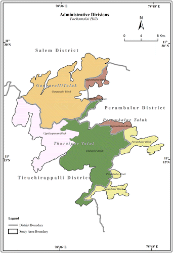
Pachamalai hills, the study area is a natural resource-rich area, inhabitated by tribals. For formulating strategies towards sustainable development of the hills, it is essential to have thorough knowledge about the lineaments of the hills. Lineaments specifically of Pachamalai hills have not been studied so far. Existing information about the lineaments of the study area are of regional nature (Balaji, Citation2000; Cenki & Kriegsman, Citation2005; Chetty, Citation1996; Drury & Holt, Citation1980; Drury, Harris, Holt, Reeves, & Wightman, Citation1984; Grady, Citation1971; Rakshit & Prabhakar Rao, Citation1989; Ramasamy, Citation1991; Ramasamy, Citation2006; Ramasamy & Balaji, Citation1993; Ramasamy, Balaji, & Kumanan, Citation1999; Reddy, Mathew, Singh, & Naidu, Citation1988; Srinivasan, Citation1974; Subrahmanya, Citation1996; Subrahmanyam, Citation1978; Sugavanam, Venkata Rao, Simhachalam, Nagal, & Murthy, Citation1977; Tirukumaran, Citation2013; Valdiya, Citation2016; Vemban, Subramanian, Gopalakrishnan, & Venkata Rao, Citation1977) and are not specific to Pachamalai hills. Furthermore, these lineaments have been mapped from small scale satellite data which is sufficient only for regional level studies. Detailed investigation into the lineaments of this hill has not been attempted so far. The present study attempts to study the lineaments exclusively of the Pachamalai hills using large-scale data. The study area is located in the central part of Tamil Nadu state of southern India, between north latitudes 11°8′52″–11°28′39″ and east longitudes 78°29′34″–78°39′29″, and forms part of the Survey of India’s topographic sheets 58 I/11, 12 and 15 of 1: 50000 scale (Figure ). The maximum north–south stretch of the hills is 37 km and along the east–west it is almost the same (36 km). The areal extent of the study area is 507.52 sq. km and is spread over three districts of the central Tamil Nadu state; while the northern and southern halves lie within Salem and Tiruchirappalli districts, respectively, a small portion on the eastern side lies in Perambalur District (Figure ).
Figure 1. Study area. Source: Compiled from the published Survey of India’s Open Series Map and Taluk maps of Government of Tamil Nadu.
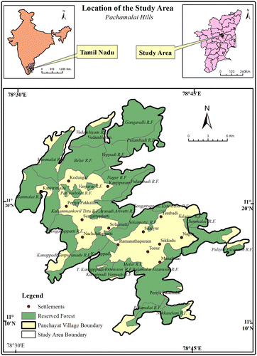
Figure 2. Administrative divisions. Source: Published Survey of India’s Open Series Map.
The objectives considered for the present study includes the extraction of lineaments of the study area (from CARTOSAT satellite data) from eight different azimuth angles and their compilation to generate lineament database for the study area, evaluation of number, length, orientation, lineament density variations and a comparative analysis of the lineaments obtained from the eight different azimuth angles considered with that of the final lineament output.
2. Geology of the study area
The study area forms part of the geologically well-known southern Granulitic Terrain of Tamil Nadu state which has experienced multiple episodes of crustal deformation (Chetty & Bhaskar Rao, Citation2006; Chetty, Vijay, Narayana, & Giridhar, Citation2003; Drury & Holt, Citation1980; Ramasamy et al., Citation1999) because of which the rocks are highly deformed and metamorphosed to granulite facies. Geochronological and isotope studies have shown crustal growth of the terrain during the period 3400 Ma. to 2500 Ma. (Geological Survey of India [GSI], Citation2006). The granulitic facies metamorphism that occurred in the region has resulted in the formation of charnockites of the region and concomitant anatexis of earlier rocks (GSI, Citation2006). Information relating to the rock types of the study area obtained from the geology map published by the Geological Survey of India in the year 2014 and ascertained by field checks reveals that the study area comprises predominantly the rocks of Charnockite Group (mostly charnockites intruded by ultrabasic rocks and granites, and pyroxene granulites) and Bhavani Group (Fissile hornblende biotite gneiss and basic dykes) of Archaen and Archaen to Proterozoic age respectively (Figure ). Of these rocks charnockites are widespread and they occupy most part of the study area (93%), the typical mineral assemblages being orthopyroxene + quartz + K-feldspars + biotite ± garnet. Geochemically the charnockites of this region has been characterized as Tonalite with high Na2O and Al2O3 contents, and the charnockitic magma of the region is found to be generated due to crustal recycling process at the mid-crustal region (George & Sajeev, Citation2015). Similar view has been expressed by Rajesh (Citation2012) who attributes the origin of these charnockites to subduction process. Rest of the 7% of the study area is occupied by pyroxene granulites, hornblende biotite gneiss, granite, basic dykes, ultrabasics and garnetiferous gabbros. The pyroxene granulites of the study area occur as linear bands trending in an almost NE–SW direction confining to the northern part of the study area especially to the Gangavalli, Pulambadi and Vedambiyam Reserved Forests. The mineral assemblage of this rock includes quartz + clinopyroxene + orthopyroxene and K-feldspar.
Figure 3. Rock types. Source: Geological Quadrangle Map of Salem District Published by Geological Survey India.
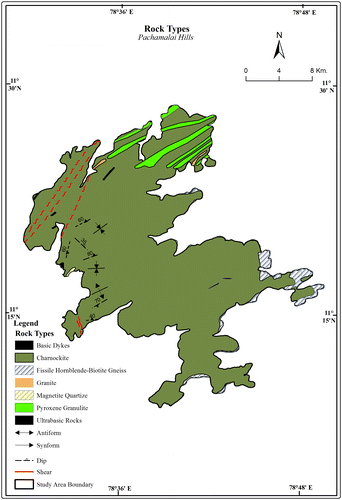
Hornblende biotite gneiss is restricted to the foot hills of the study area especially to the eastern and south eastern parts. The mineral assemblage of the rock is quartz-hornblende-biotite-K-feldspar-plagioclase. Granites are confined to the northern part of the study area especially to the Vedambiyam and Pulambadi Reserved Forests and are seen as enclaves within charnockites. These small plutons were emplaced as culmination of migmatization that occurred in the area during the Late Archaean-Early Proterozoic Periods (George & Sajeev, Citation2015). The basic dykes of the study area are seen transecting the charnockites and are exposed in three locations. One of them occurs in the northern part of the study area (near Vedambiyam) trending in a NNE–SSW direction while the other two are found in the eastern part of the study area (near Nagur and Sikkadu villages) trending in ENE–WSW to nearly E–W direction. A small patch of ultrabasic rocks occurs in the western part of the study area within the Sengattupatti Reserved Forest.
The strike direction of the foliation of the major rock type of the study area, the charnockites, is predominantly NE–SW. Two prominent synform structures are found on the western part of the study area, one of which is in the Periyasolai Reserved Forest and the other in the north eastern side of Sengattupatti Reserved Forests. A prominent antiform structure is found in the south eastern side of the Sengattupatti Reserved Forests. Two prominent NNE–SSW trending shear zones pass through the Manmalai Reserved Forest in the north western part of the study area (Figure ).
3. Methodology
Literature relevant to the present study which include those relating to the various aspects of lineaments and those pertaining to the rocks, geological structure and geological history of the study area were collected, compiled and reviewed in order to have a thorough understanding of the theme under study and the geology of the area. In the next stage, lineaments of the study area were extracted from Digital Elevation Model (DEM) generated from CARTOSAT-1 satellite data (P143 R52) by the National Remote Sensing Centre (NRSC) which is freely downloadable (http://bhuvan.nrsc.gov.in/data/download/index.php). Topographic features which represent lineaments such as straight valleys, continuous scraps, straight streams segments and rock boundaries, systematic off set of streams, sudden tonal variations and alignment of vegetation were identified and digitized on screen. Lineaments were extracted from eight different azimuth angles (45°, 90°, 135°, 180°, 225°, 270°, 315° and 360°) to ensure unbiased mapping of all lineaments of the area under study as demonstrated from a number of studies (Hubbard, Mack, & Thompson, Citation2012; Muhammad & Awdal, Citation2012; Tahir, Garba, & Hassan, Citation2015). Furthermore, interpretation of lineaments at each of these azimuth angles was done at two different scales (1:50000 and 1: 80000 scales) to ensure mapping of lineaments of all sizes. The extracted lineaments from each azimuth angle were compared with other data sources such as topographic maps and high resolution Google images to eliminate non-geological lineaments. This elimination of non-geological lineaments was performed for all the eight lineament maps extracted from the eight different azimuth angles. After this elimination process, the remaining lineaments in each of the eight different azimuth angles were stored in eight different separate GIS shape files.
This was followed by combining all the lineaments obtained from these eight different shape files into a single shape file. From this output the redundant/duplicate lineaments were eliminated and the final lineament map of the study area was generated. In the next stage, the final lineament map was analysed for number of lineaments, length of lineaments, lineament density from the computations made using ArcGIS software 10.2 version. Orientation of lineaments of the study area were also analysed for which rose diagrams generated using Rockworks software 2016 version were made use of. This was followed by compilation of results based on which conclusions have been made.
4. Results and discussion
Lineaments extracted from each of the eight azimuth angles considered for the study (45°, 90°, 135°, 180°, 225°, 270°, 315° and 360°) and the final lineament output (generated by compiling the lineaments from all the eight azimuth angle outputs) are shown in Figures and , respectively. These lineament data-sets were made use of to estimate their numbers, length and orientations besides spatial variation in lineament density. The salient findings from these estimations are discussed in the following section.
Figure 4a. Lineaments extracted by 45 degree azimuth angle.
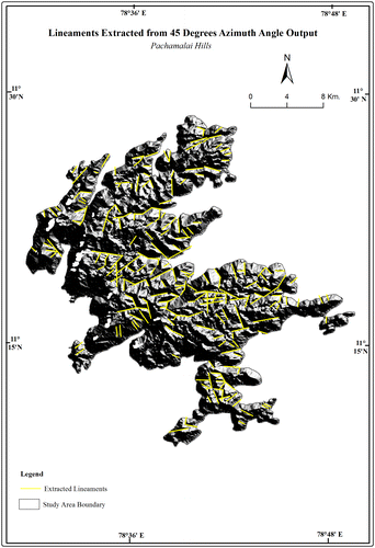
Figure 4b. Lineaments extracted by 90 degree azimuth angle.
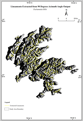
Figure 4c. Lineaments extracted by 135 degree azimuth angle.
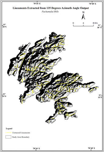
Figure 4d. Lineaments extracted by 180 degree azimuth angle.
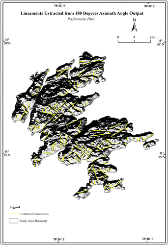
Figure 4e. Lineaments extracted by 225 degree azimuth angle.
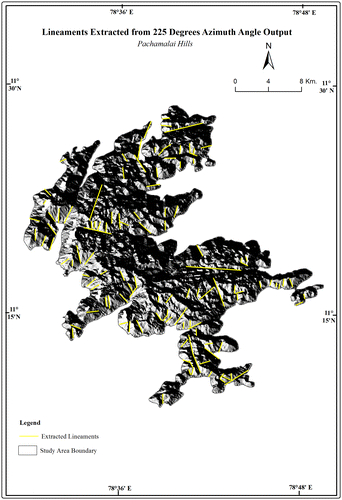
Figure 4f. Lineaments extracted by 270 degree azimuth angle.
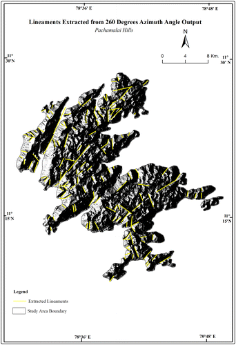
Figure 4g. Lineaments extracted by 315 degree azimuth angle.
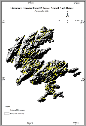
Figure 4h. Lineaments extracted by 360 degree azimuth angle.
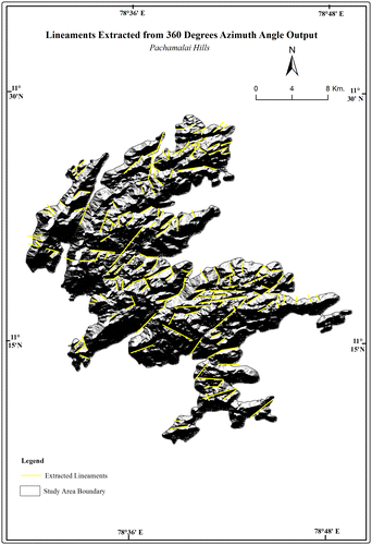
Figure 5. Final output.
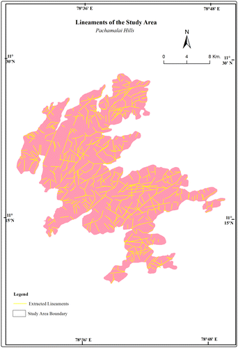
The total number of lineaments of the study area, estimated from the final lineament output is 561. However, lineaments extracted individually from various azimuth angles were far lesser in number and it varied from 116 (at 225° azimuth angle) to 223 lineaments (at 45° azimuth angle). Among the eight azimuth angles, greater number of lineaments (223) were extractable from the 45° azimuth angle. However, even from this seemingly most favourable azimuth angle data for lineament extraction, the number of lineaments extracted (223) was only about 40% of the lineaments extracted from the final lineament output (561 lineaments) (Table ).
Table 1. Number of lineaments and length from various azimuth angles.
The total length of lineaments of the study area is 680.89 km. However, the length of lineaments estimated from the eight individual azimuth angles were far lesser, varying from 154.30 km (at 225° azimuth angle data) to 261.21 km (at 45° azimuth angle output), which is reflection of variation in the extractable lineaments at different azimuth angles discussed earlier.
Based on the length, lineaments of the study area (Figure ) were classified as very short (<1 km), short (1–2 km), medium (2–3 km), long (3–4 km) and very long (>4 km). Estimation of the number of lineaments in each of these classes shows that of the 561 lineaments of the study area, 291 are very short and 211 are short lineaments. These two lineament classes together constitute about 90% of the lineaments of the study area. Dominance of such smaller lineaments have also been reported from Adwa river basin of Vindhyan plateau (Nagal, Citation2014), Medium sized lineaments are lesser in number and they constitute only 7% of the lineaments of the study area. Long and very long lineaments are fewer in number and they constitute just about 2% each of the lineaments of the study area (Table ).
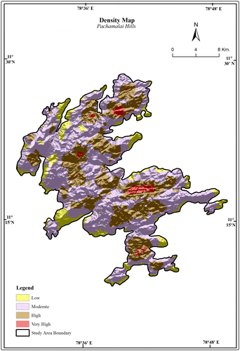
Lineament density, the total length of lineaments per unit area was estimated and analysed in order to demarcate geologically weaker zones. For understanding the spatial variation of lineament density, a grid of cells 1 sq. km each was overlaid over the final lineament map of the study area and the length of lineaments in each grid was estimated. Based on the range of such estimated lineament density values of the grids, the various lineament density classes such as low (<.5 km/sq. km), moderate (.5–1.5 km/sq. km), high (1.5–2.5 km/sq. km) and very high (>2.5 km/sq. km) were demarcated (Figure ) using ArcGIS software. In the study area lineament density ranges from 0 to 3.24 km/sq. km. In most part of the study area (57%), the density of lineaments is moderate. The density is found to be high and very high in about 30 and 2%, respectively, and are restricted to the reserved forests such as Palamalai extension, Nakkasalem, Solaimatti and Gangavalli, besides the villages of Thenpuranadu and Vadapuranadu. Studies have shown that areas of high lineaments density reflects high degree of rock fracturing (Edet, Okereke, Teme, & Esu Citation1998), shearing (Chandrasekhar, Martha, Venkateswarlu, Subramanian, & Kamaraju, Citation2011), intensity of deformation (Hung, Batelaan, San, & De Smedt, Citation2004), permeability (Masoud & Koike, Citation2011), higher groundwater yield (Sener, Davraz, & Ozcelik, Citation2005), mineral occurrences associated with hydrothermal alteration zones (Kiran Raj & Ahmed, Citation2014; Rameshchandra Phani, Citation2014), higher soil erodibility (Jawahar Raj, Citation2001) and slope failures (Kiran Raj & Ahmed, Citation2014), etc. Thus based on the above established relationship of high lineament density with the above described factors, it can be inferred that in the high and very high lineament density zones of the study area, the degree of rock fracturing, shearing, intensity of deformation, rock permeability, groundwater yield and soil erodibility, would be higher. These areas render themselves unsuitable for the construction of dams and reservoirs as the possibility of water leakages into the subsurface, slope and dam failures, rate of sedimentation are higher.
Figure 6. Lineament density. Source: Generated from Cartosat -1 Satellite’s DEM Data.
Rose diagrams were constructed for the finalized lineament output (to understand the orientation of lineaments in the study area), lineament outputs of eight different azimuth angles (to understand the existence of preferred orientation(s) of lineaments, if any, in different azimuth angles) and outputs of various lineament length classes (to understand the existence of size-wise preferred orientation(s) of lineaments) using the Rockworks software – 2016 version (Figure (a)–(h)) (Table ).
Figure 7. Rose diagrams depicting orientation of lineaments at various azimuth angles.
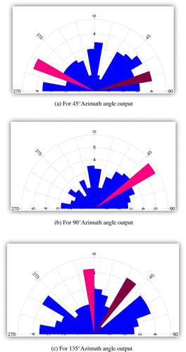
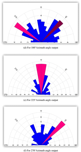
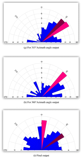
Table 2. Number of lineaments and length of various lineament length classes.
Rose diagrams constructed for the final lineament output shows that though the lineaments of the study area are diverse in orientation, those oriented in N–S, ENE–WSW and NE–SW directions are predominant (Figure (i)). The diverse orientations of the lineaments of the study area reflect the multiple episodes of deformation events that have occurred in the region through geologic time as reported by Anderson (Citation1951), Drury and Holt (Citation1980), Bartlett, Dougherty, Harris, Hawkesworth, and Santosh (Citation1998), Ramasamy et al. (Citation1999), Chetty et al. (Citation2003), Bhaskar Rao et al. (Citation2003), Chetty and Bhaskar Rao (Citation2006) and Tirukumaran (Citation2013). The predominant orientation of the lineaments of the study almost corroborates with the results of several regional studies on lineaments (Balaji, Citation2010; Rakshit & Prabhakar Rao, Citation1989; Subramanian & Mani, Citation1979; Tirukumaran, Citation2013) and with the orientation of a number of prominent geological features of the study area such as the trend of the prominent regional Gangavalli Shear Zone that passes through the study area, trend of basic dykes and pyroxene granulitic bands which are all oriented in almost NE–SW direction.
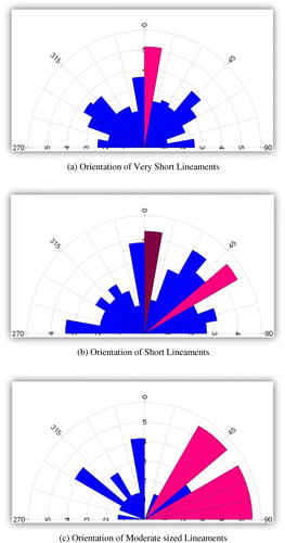
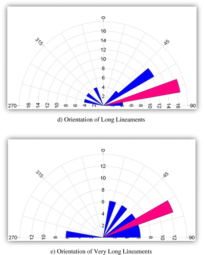
The analysis of orientation of lineaments of different sizes (Figure (a)–(c)) shows distinct size-wise preferential orientation. North–south direction is found to be the predominant orientation of very short and short lineaments in addition to NE–SW direction of the later. Moderate-sized lineaments are oriented predominantly in three directions which includes NE–SW, ENE–WSW and E–W, while longer and very longer lineaments are predominantly oriented in ENE–WSW direction. Thus, with increasing lineament size the predominant orientation changes from N–S to NE–SW towards ENE–WSW.
Figure 8. Rose diagrams depicting orientation of lineaments at various lineament length classes.
The analysis of the orientation of lineaments extracted individually from eight different azimuth angles reveals that NE–SW-oriented lineaments are predominant in most of the azimuth angles which includes 90°, 135°, 270°, 315° and 360°. In two azimuth angles viz., 135° and 225°, the predominant orientation is N–S. In case of 45° and 180° azimuth angles, the lineaments are predominantly oriented in WNW–ESE and NW–SE directions, respectively. These variations clearly shows that lineaments oriented in NE–SW direction is easily discernible in most of the azimuth angles, whereas N–S-oriented lineaments are far more easily discernible in 135° and 225° azimuth angles while WNW–ENE and NW–SE lineaments are far more easily discernible in 45° and 180° azimuth angles.
5. Conclusion
The present study has helped to derive a comprehensive lineament database, generated by compiling lineaments extracted from eight different azimuth angles. This data can serve as a valuable input in evolving strategies towards developmental and management planning of this natural resource-rich hill which is facing threats from anthropogenic activities. Furthermore, the analysis of lineament number, length and predominant orientation from eight different azimuth angles and the compiled final lineament output clearly shows that extraction of lineaments from any single azimuth angle, which has been the widely followed practice, is inadequate to provide a reliable account of the lineaments. The study further underlines the need to extract lineaments from varied azimuth angles and their compilation, for getting a reliable database of lineaments.
Disclosure statement
No potential conflict of interest was reported by the authors.
References
- Anderson, E.M. (1951). The dynamics of faulting. Edinburgh: Oliver and Boyd.
- Balaji, S. (2000). Seismic prone lineaments of Tamil Nadu, India and its impact on environment through remote sensing. International Archives of the Photogrammetry and Remote Sensing, 33(7), 101–105.
- Balaji, S. (2010). A palaeostress analysis of Precambrian granulite terrain of northern Tamil Nadu, Peninsular India – A remote sensing study. Asian Journal of Geoinformatics, 10(4), 12–16.
- Bartlett, J.M., Dougherty, J.S., Harris, N.B.W., Hawkesworth, C.J., & Santosh, M. (1998). The application of single zircon evaporation and Nd model ages to the interpretation of polymetamorphic terrains: An example from the proteorozoic mobile belt of south India. Contributions to Mineralogy and Petrology, 131, 181–195.
- Bhaskar Rao, Y.J., Janardan, A.S., Vijaykumar, T., Narayana, B.L., Dayal, A.M., Taylor, P.N., & Chetty, T.R.K. (2003). Sm–Nd model ages and Rb–Sr isotropic systematics of charnockites and gneisses across the Cauvery shear zone of southern India: Implications for the Archean-Neoproterozoic terrain boundary in the southern granulite terrain. In M. Ramakrishnan (Ed.), Tectonics of southern granulite terrain: Kuppam-Palani geotransect. Geological Society of India Memoir 50 (pp. 297–317). Bangalore: Geological Society of India.
- Cenki, B., & Kriegsman, L.M. (2005). Tectonics of the neoproterozoic southern granulite terrain. Precambrian Research, 138, 37–56.
- Chandrasekhar, P., Martha, T.R., Venkateswarlu, N., Subramanian, S.K., & Kamaraju, M.V.V. (2011). Regional geological studies over parts of deccan syneclise using remote sensing and geophysical data for understanding hydrocarbon prospects. Current Science, 100(1), 95–99.
- Chetty, T.R.K. (1996). Proterozoic shear zones in southern granulite terrain. In M. Santosh & M. Yoshida (Eds.), The Archaean and Proterozoic terrains in southern India within East Gondwana. Memoir Gondwana Research Group 3 (pp. 77–89).
- Chetty, T.R.K., & Bhaskar Rao, Y.J. (2006). The Cauvery shear zone, southern granulite terrain, India: A crustal-scale flower structure. Gondwana Research, 10(1–2), 77–85.
- Chetty, T.R.K., Vijay, P., Narayana, B.L., & Giridhar, G.V. (2003). Structure of the Nagavali shear zone, Eastern Ghats mobile belt, India: Correlation in the East Gondwana reconstruction. Gondwana Research, 6(2), 215–229.
- Drury, S.A., Harris, N.B.W., Holt, R.W., Reeves, S.G.J., & Wightman, R.T. (1984). Precambrian tectonics and crustal evolution in South India. The Journal of Geology, 92, 3–20.
- Drury, S.A., & Holt, R.W. (1980). The tectonic framework of South Indian Craton; A reconnaissance involving Landsat imagery. Tectonophysics, 65, T1–T15.
- Edet, A., Okereke, C., Teme, S., & Esu, E.O. (1998). Application of remote-sensing data to groundwater exploration: A case study of the Cross River State, southeastern Nigeria. Hydrogeology Journal, 6, 394–404. doi:10.1007/s100400050162
- George, P.M., & Sajeev, K. (2015). Crustal evolution of Kolli-Massif, Southern India. Journal of the Indian Institute of Science, 95(2), 187–202.
- Grady, J.C. (1971). Deep main faults in South India. Journal of the Geological Society of India, 12(1), 56–62.
- GSI. (2006). Geology and mineral resources of the states of India, Part IV – Tamil Nadu and Pondicherry. Geological Survey of India Miscellaneous Publications, 30, 71.
- Hubbard, B.E., Mack, T.J., & Thompson, A.L. (2012). Lineament analysis of mineral areas of interest in Afghanistan ( Open-File Report 2012–1048) (p. 28). Reston, VA: United State Geological Survey.
- Hung, L.Q., Batelaan, O., San, D.N., & De Smedt, F. (2004, September 13–18). Lineament analysis for the groundwater in Karst fractured rocks in the Suoimuoi Karst catchment. In O. Batelann, M. Dusar, J. Masschelein, V.T. Tam, T.T. Van, & N.X. Khien (Eds.), Proceedings of the international transdisciplinary conference on development and conservation of Karst regions, Hanoi, Vietnam.
- Jawahar Raj, N. (2001). Integrated Terrain and natural resource evaluation of Kolli hills, Namakkal district, Tamil Nadu: A study using remote sensing and GIS ( Unpublished PhD thesis). Bharathidasan University, Tiruchirappalli.
- Kiran Raj, S., & Ahmed, S.A. (2014). Lineament extraction from Southern Chitradurga schist belt using Landsat TM, ASTERGDEM and Geomatics techniques. International Journal of Computer Applications, 93(12), 12–20.
- Masoud, A., & Koike, K. (2011). Auto-detection and integration of tectonically significant lineaments from SRTM DEM and remotely-sensed geophysical data. ISPRS Journal of Photogrammetry and Remote Sensing, 66, 818–832.
- Muhammad, M.M., & Awdal, A.H. (2012). Automatic mapping of lineaments using shaded relief images derived from digital elevation model (DEM) in Erbil-Kurdistan, northeast Iraq. Advances in Natural and Applied Sciences, 6(2), 138–146.
- Nagal, S. (2014). Mapping of lineaments in Adwa River Basin using remote sensing and GIS techniques. European Academic Research, II(7), 9646–9658.
- Rajesh, H.M. (2012). A geochemical perspective on charnockite magmatism in Peninsular India. Geoscience Frontiers, 3(6), 773–788. doi:10.1016/j.gsf.2012.04.003
- Rakshit, A.M., & Prabhakar Rao, P. (1989). Megalineaments on the face of the Indian sub-continent and their geological significance. Memoirs-Geological Society of India, 12, 17–24.
- Ramasamy, S.M. (1991). Remote sensing of river migration in Tamil Nadu. NNRMS Bulletin, 14, 25–28.
- Ramasamy, S.M. (2006). Remote sensing and active tectonics of South India. International Journal of Remote Sensing, 27(20), 4397–4431.
- Ramasamy, S.M., & Balaji, S. (1993). Aid of remote sensing in mapping geofractures of environmental significance in Tamil Nadu. Journal of the Indian Society of Remote Sensing, 21(3), 109–118.
- Ramasamy, S.M., Balaji, S., & Kumanan, C.J. (1999). Tectonic evolution of early Precambrian south Indian shield (rocks) using remotely sensed data. Journal of the Indian Society of Remote Sensing, 27(2), 91–104.
- Rameshchandra Phani, P. (2014). A GIS based correlation between lineaments and gold occurrences of Ramagiri – Penakacherla schist Belt, Eastern Dharwar Craton, India. International Journal of Geology and Earth Sciences, 4(3), 259–267.
- Reddy, A.G.B., Mathew, M.P., Singh, Baldev, & Naidu, P.S. (1988). Aeromagnetic evidence of crustal structure in the granulitic Terrane of Tamil Nadu-Kerala. Journal of the Geological Society of India, 32, 368–381.
- Retrieved from http://bhuvan.nrsc.gov.in/data/download/index.php
- Sener, A., Davraz, A., & Ozcelik, M. (2005). An integration of GIS and remote sensing in groundwater investigations: A case study in Burdur, Turkey. Hydrogeology Journal, 13, 826–834.
- Srinivasan, V. (1974). Geological structures in Attur Valley, Tamil Nadu, and based on photo-interpretation. Journal of the Geological Society of India, 15, 89–93.
- Subrahmanya, K.R. (1996). Active intraplate deformation in south India. Tectonophysics, 262(1–4), 231–241.
- Subrahmanyam, C. (1978). On the relation of gravity anomalies to geotectonics of the Precambrian terrains of the South Indian shield. Journal of the Geological Society of India, 19, 251–263.
- Subramanian, K.S., & Mani, G. (1979). Geomorphic significance of lateritic bauxite in the Shevaroy and Kollimalai Hills, Salem District, Tamil Nadu. Journal of the Geological Society of India, 20(6), 282–289.
- Sugavanam, E.B., Venkata Rao, V., Simhachalam, J., Nagal, S.C., & Murthy, M.V.N. (1977). Structure tectonics metamorphism magnetic activity and metallogeny in parts of northern Tamil Nadu. Journal of Geological Society of India Miscellaneous Publications, 34, 95–101.
- Tahir, A.G., Garba, M.L., & Hassan, C. (2015). Lineaments analysis to identify favourable areas for groundwater in Kano City Northwestern Nigeria. Journal of Environment and Earth Science, 5(2), 1–7.
- Tirukumaran, V. (2013). Geoinformatic modelling for certain Georesources and Geohazards of Attur Valley Tamil Nadu India (Unpublished PhD thesis). Bharathidasan University, Tiruchirappalli.
- Valdiya, K.S. (2016). The making of India: Geodynamic evolution (2nd ed., p. 924). Basel: Springer International Publishing.
- Vemban, N.A., Subramanian, K.S., Gopalakrishnan, K., & Venkata Rao, V.V. (1977). Major faults dislocations and lineaments of Tamil Nadu. Journal of Geological Society of India Miscellaneous Publications, 31, 53–56.