
ABSTRACT
The Palar River basin is one of the major rivers in southern peninsular India. Morphometric analysis coupled with drainage network analysis was carried out for the Palar River basin to understand its drainage characteristics and the drainage network geometry with reference to tectonics. The morphometric analysis has been carried out using ‘bearing azimuth and drainage (bAd) calculator’ which a new and easy methodology for extraction of watershed morphometric parameters. The entire Palar River basin has been divided into five major sub-basins and various linear, areal, and relief morphometric parameters were calculated. The sub-basins I, II, and III reflect low to medium stream frequency (Fs) and moderate drainage density (Dd) and a high bifurcation ratio of various stream orders signifies that they are surging through tectonically active areas, followed by high overland flow and less recharge into the subsurface resulting in low groundwater potential. Moreover, sub-basins IV and V show the relatively low overland flow, which helps to percolate water, hence ground water potential will be higher. The morphometric result suggests that the drainage network geometry is variously controlled by recent tectonics. Lineaments trending majorly NW-SE, NE-SW, and E-W mark the major drainage network in Palar River drainage basin. Lower order streams and higher order streams follow NW-SE, NE-SW lineaments. Which also points toward the tectonic control of drainage in Palar River. As a result of channel orientation due to tectonic activity: (i) most channels are A-type or B-type associated with the lineaments, (ii) the pattern of the drainage network is dendritic, rectangular sometime trellis too, and (iii) the main rivers flow longitudinally to the predominant lineament direction.
Introduction
A drainage basin reflects its geology with subsurface lithology and geomorphic processes that have operated over time and slope as indicated by various morphometric studies (Burrough & McDonnell, Citation1998; Chorley, Schumm, & Sugden, Citation1984; Clarke, Citation1966; Cox, Citation1994; Evans, Citation1984; Horton, Citation1945; Merritts & Vincent, Citation1989; Muller, Citation1968; Oguchi, Citation1997; Strahler, Citation1952). Drainage basin analysis using morphometric parameters and its channel network reveals its hydro geological behavior, which also helps to quantify the changes in the drainage basin and groundwater as resource potential and tectonic or structural disturbances if any (Pophare & Balpande, Citation2014). The most important applications of the quantitative morphometric analysis include flood hazard evaluation (Pattom, Citation1988; Seta, Monte, & Pascoli, Citation2005) and understanding of the tectonic processes (Mahmood & Gloaguen, Citation2012; Pérez-Peña, Azor, Azañon, & Keller, Citation2010). Moreover, it also shows the interface of existing climate, geology and geomorphology of the basin.
The linkage among different drainage parameters are well established (Horton, Citation1945; Strahler, Citation1957; Pakhmode, Kulkarni, & Deolankar, Citation2003; Magesh and Chandrasekhar Citation2012; Markose et al. Citation2014; Pophare & Balpande, Citation2014). In tectonically active regions, the drainage network reveals the relation between surface processes and the structural deformations (Burbank & Anderson, Citation2001; Delcaillau, Carozza, & Laville, Citation2006). Though, limited studies have focused on the relationship among channel orientation and tectonics (Beneduce, Festa, Francioso, Schiattarella, & Tropeano, Citation2004; Hodgkinson, McLoughlin, & Cox, Citation2006; Lupia Palmieri et al., Citation1998). A systematic approach toward the development of drainage basin in the area demands a detailed understanding to delineate morphometric parameters and structural control in the drainage basin (Rai, Mohan, Mishra, Ahmad, & Mishra, Citation2014; Ribolini & Spagnolo, Citation2008).
Evaluation of morphometric parameters requires measurement of linear, aerial, relief, and gradient parameters of the channel network to evaluate the hydrological system characteristics of the basin area (Horton, Citation1932; Magesh, Chandrasekar, & Soundranayagam, Citation2011; Majumdar, Citation1982; Nag & Chakraborty, Citation2003; Nautiyal, Citation1994). Furthermore, the occurrence of floods, sediment yields, erosion rates, surface runoff, and flow intensity of the drainage system can be estimated using the morphometric parameters (Gardiner, Citation1990; Ozdemir & Bird, Citation2009).
Several software packages available for analyzing drainage basin parameters in raster grids of satellite images and digital elevation models (DEMs). All these extensions and algorithms are used for extraction of drainage networks and evaluation of morphometric parameters necessitate preparation of various thematic maps (Harvey & Eash, Citation1996; Lin, Chou, Lin, Huang, & Tsai, Citation2008; Shahzad & Gloaguen, Citation2011a, Citation2011b; Thomas, Joseph, Thrivikramji, Abe, & Kannan, Citation2012). Bearing azimuth and drainage (bAd) calculator is a software specifically designed for calculating morphometric parameters in GIS environment. The software package consists of several methods for drainage line processing and is designed to work on networks with Strahler’s stream order in ESRI lineshape file format (Markose, Dinesh, & Jayappa, Citation2014). In the Southern Indian peninsular region, a number of studies have been carried out to study the morphometric characteristics of the drainage basins (Magesh and Chandrasekhar, Citation2011; Markose et al., 2013; Kaliraj, Chandrasekar, & Magesh, Citation2014). However, till date no work on detailed morphometric and drainage network analysis of the Palar River basin with implications on tectonic activity has been carried out. Hence, the present study aims to evaluate and delineate the morphometric parameters using bAd calculator program and establish the relationship between the geometry/channel orientation of the drainage network and the lineaments in different sub-basins of the Palar River.
Study area
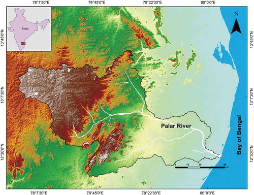
The Palar River () is one of the major ephemeral rivers in southern peninsular India. The river has been dammed for irrigation purpose, particularly along its course in Tamil Nadu. Number of work has been carried out on the Palar River basin to understand its channel avulsion, drainage system, flood events in the Palar basin, etc. (Ramasamy, Kumanan, Selvakumar, & Saravanavel, Citation2011; Resmi, Achyuthan, & Jaiswal, Citation2017; Subramanya, Citation1996; Vaidyanathan, Citation1971) but drainage systems of this region have received little attention with respect to the neotectonic activity in the drainage pattern and their geometric settings.
Figure 1. Location map of the study area with Palar River drainage basin.
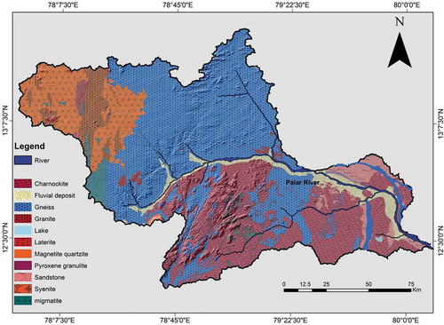
The Palar River basin () comprises granitoid gneisses (Hornblende gneiss, Hornblende-Biotite gneiss, and Migmatitic gneiss), granitoid intrusive and supracrustal rocks of tholeiitic and komatiitic affinity in the upper reaches (Balakrishnan & Rajamani, Citation1987). Charnockite are present in the middle reaches of the Palar River, and after Arcot the river drains the recent alluvium and lower Gondwana formation (Mesozoic formation is represented by upper Gondwana formation) followed by granulites and lastly the coastal alluvium.
Figure 2. Geology map of the Palar River basin.
Geomorphology of the area is represented by denuding hills, which are structurally controlled with or without complex folding and faulting, residual hills, plateaus, valley fill, pediments, and buried pediments, pediplains, and alluvial plains. Pediments are gently sloping smooth surface of erosional bedrock with thin detritus. Alluvial plains land surface produced by extensive deposition of alluvium, usually adjacent to a river that periodically overflows its banks. The major part of the area is characterized by an undulating topography with innumerable local depressions.
Materials and methods
Morphometric analysis
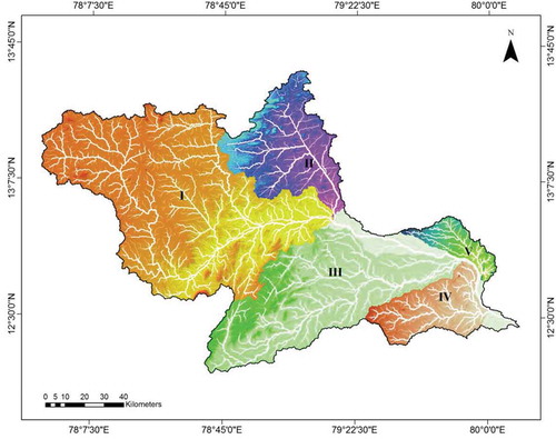
In the present study, the hierarchical orders of the drainage networks were derived from the ASTER DEM (30 m) based on the D8 (multidirectional method) method using “Hydrology Tool” in ArcGIS software10.3 version. The drainage network has been extracted by giving the threshold value of 0.5 to the grid for extracting from DEM and then it was confirmed with the Survey of India topographical map (1:25,000). In order to calculate the morphometric parameters, sub-basins within the Palar basin were delineated based on the stream order eighth, seventh, and sixth. For the present study, the Upper Palar basin has been denoted as sub-basin I, the Poiney sub-basin as sub-basin II and the Cheyyar sub-basin as sub-basin III and these sub-basins I–III are drained by the eighth-order stream. Further, the Killiyar basin is denoted as the sub-basin IV followed by the lower Palar denoted as sub-basin V, and these two sub-basins fall is drained by the seventh- and sixth-order streams, respectively (). For calculating the morphometric parameters, bAd calculator is a computer program developed by Dinesh, Markose, and Jayappa (Citation2012) and Markose et al. (Citation2014). This program calculates the morphometric parameters in user defined grids and sub-basins (Dinesh et al., Citation2012; Markose et al., 2013). The program package consists of several methods for drainage line processing and quantitative analysis of the watershed parameters. The various formulae used for the calculation of these parameters are shown in .
Table 1. List of formulae used in bAd calculator for calculation of the drainage basin parameters.
Figure 3. SRTM-derived DEM-map of the Palar River basin and five sub-basins drainage showing the drainage network. (a) sub-basin I – Upper Palar basin (b) sub-basin II – Poiney sub-basin (drained by Poiney River); (c) sub-basin III – Cheyyar sub-basin (drained by Cheyyar River), (d) sub-basin IV – Killiyar sub-basin (drained by Killiyar River), (e) sub-basin V – Lower Palar Sub-basin.
The quantitative morphometric parameters were calculated using bAd calculator mainly in three aspects, such as linear, areal, and relief, in order to evaluate the morphometric parameters of the Palar River basin. The relationships among drainage basin and the stream networks have been understood by the stream number, stream length, length of the overland flow, bifurcation ratio, and stream length ratio.
Drainage network and lineaments analysis
We investigated the drainage network of the Palar River basin as follows: within each sub-basin focused on the directional properties of (1) every channel from the first to the sixth order, and (2) other linear morphological features (such as lineaments and faults). Using specific GIS (OAT) tools, estimated the direction of every channel in the drainage network. Rose diagrams were prepared for the basin for first- to seventh-order streams and for the lineaments in the basin to estimate the linkage with the trend of the drainage network and lineaments. This analysis was performed to check whether the streams of the different orders are controlled by tectonic activity in different ways (Ribolini & Spagnolo, Citation2008).
Results and discussion
Morphometric parameters
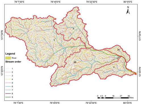
The Palar River basin parameters such as area, perimeter, and basin length of the major sub-basins is presented in . All the values were extracted from the sub-basins using the calculate geometry tool available in ArcGIS 10.3. The streams of the Palar River Basin have been ranked according to the Strahler’s (Citation1964) classification () and discussed as follows.
Table 2. Basin and areal morphometric aspects of the five sub-basins of Palar River drainage basin.
Figure 4. Stream ordering of the five sub-basins of the Palar River.
(a) Aerial aspect
The areal aspects of a drainage basin reflect the influence of lithology, geological structure, climatic conditions, and denudation history of the basin. The aerial aspects consist of morphometric parameters such as drainage density (Dd), stream frequency (Fs), elongation ratio (Re), and circulatory ratio (Rc).
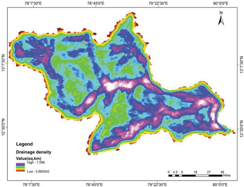
The Dd values of the Palar River basin range from 0.84 to 2.63 km/km2 (). The Dd value is low (˂2) for all the sub-basins except for the sub-basin-V. Low values of Dd in the sub-basins are because of the presence of permeable sub-surface lithology, dense vegetation, and low relief (). Because of the huge alluvial thickness in all the Palar River the permeability will be greater. The high Dd value indicates of greater run-off and as a result low infiltration rate. While, low drainage density of an area implies low run-off and high infiltration.
Figure 5. Drainage density (Dd) map of the Palar River basin.
In the present study, Fs ranges from 0.64 to 4.34. Fs shows an increasing tendency from upstream to downstream. The eastern part of the basin shows moderate Fs, whereas; NW and SW parts of the basin exhibit low Fs. Fs mainly depends on the lithology of the basin, high drainage frequency will lead to a more surface runoff. While low drainage frequency leads to more percolation and therefore more groundwater potential (Markose et al., Citation2014).
Elongation ratio can be grouped into three categories: (a) circular (>0.9), (b) oval (0.9–0.8), and (c) less elongated (<0.8). Sub-basins I, II, and V are oval while sub-basins III and IV reflect values < 0.8 indicating less elongation in shape. These deviations from the elongated shape of the sub-basins within the watershed basin are due to the effects of structural disturbances (Sreedevi, Subrahmanyam, & Ahmed, Citation2005). Furthermore, the low Re values of the sub-basins designate their lesser vulnerability to flash floods and as a result and easier flood management (Markose et al., Citation2014). Circulatory ratio values of the sub-basins ranging from 0.21 to 0.29, can be attributed to differences in the geomorphological features, strong relief, and slope occurring in the Palar River basin (). Form factor (Ff): low form factor is indicated by basins which are elongated and narrow and high form factor indicates that the basin is broad and wide. Ff ranges from 0.22 to 0.59.
Linear aspect
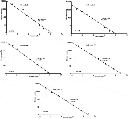
A linear aspect of a drainage network reveals behavior of a river and its tributaries from head to mouth along with lithological and structural controls of the drainage basin. The linear aspects consist of stream number, stream order, stream length, mean stream length, stream length ratio, and bifurcation ratio (). Stream number is the total number of streams present in a basin. The variations in stream order and the sub-basin are largely due to physiographic and structural conditions of the region. Plots of log of stream number against stream order for each sub-basin are represented in (). R2 values imply that the best fitted model to explain the relation of stream order and stream number is the exponential trendline.
Table 3. Linear morphometric parameters of sub-basins of Palar River drainage basin.
Figure 6. Semi-logarithmic plot of the stream number against stream orders for the five sub-basins and Palar River basin. Weighted mean bifurcation ratio (Rb) for each sub basin is given in the plots. Regression coefficient values for the exponential curves are indicated.
The stream length is the maximum area of the basin in a particular order. The different stream orders are derived from the extracted stream network. Using this extracted stream network, estimated the hydrological characteristics of the drainage extent and the bedrock. The stream length ratios vary at the basin and sub-basin levels. The value of RL in the sub-basin variables is presented in . RL of stream orders different due to diversity in slope and topographic conditions, and has a positive relationship with the surface flow discharge and erosional stage of the sub-basin.
Bifurcation (Rb) ratios generally range between 3.0 and 5.0 for basins that the geologic structures deform the drainage pattern. The mean bifurcation ratio (Rbm) characteristically ranges between 3.0 and 5.0 where, geological structures on the drainage network has no influence (Verstappen, Citation1983). The bifurcation ratio of the sub-basin of the Palar River basin varies from 1.25 to 8.5 () which indicates that the geological structures affects the drainage networks and systematic branching pattern of the streams. The length of overland flow can be estimated by taking the reciprocal of the drainage density and the inverse of the average slope of the channel and the ‘Lg’ value of the Palar River basin is ranges from 0.6 to 2.38 ().
Relief aspect
Relief aspect of a basin is the elevation difference mainly the structure elevation ( and ). The relief aspect includes total relief and relief ratio and these are calculated and presented in . Relief of the Palar River basin is lowest in the sub-basin V (199 m) and it rises to 1190 m in sub-basin I while the middle and lower portion of the river exhibit high relief. The relief ratio of the sub-basins of the Palar River ranges from 3.06 to 15.57 (). Higher relief values point to low infiltration and high run-off conditions (Patton, Citation1988).
Table 4. Relief parameters and Sinuosity index of the Palar River basin.
Sinuosity index (Si)
Tectonic activity is one of the main forces that control the changes of valley floor slope, together with local changes of sediment and water supply due to river junctions or changes in lithology (Schumm, Citation1986). The sub-basins of Palar River have sinuosity ratio varying from 1.11 to 1.54 (). The sub-basins I, II, and III are sinuous. Sub-basin IV is rather straight while sub-basin V is meandering in nature. The total Palar River basin, when considered as a single system shows sinuous nature (Si = 1.34).
Analysis of drainage network and lineaments
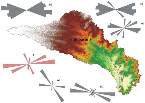
Drainage analysis helps to delineate the evaluation of the relationship which exist between the geometry of the drainage network along with the tectonic structures (Burbank & Anderson, Citation2001; Delcaillau et al., Citation2006; Ribolini & Spagnolo, Citation2008; Van der Beek, Champel, & Mugnier, Citation2002). The present study, we are examining the drainage network of the entire Palar River basin. The sub-basin I is characterized by dendritic type pattern geometry and they flow approximately perpendicular to the main divide (). The main river stems that drain the upper portion of sub-basin I flow initially from NW to SE. In the middle portion of the sub-basin I is almost right-angled bend diverts the main stems from their initial direction (SE-NW) in a perpendicular direction (). However, in sub-basin II is also illustrating a dendritic type, drainage pattern and flows along NW-SE direction. Thus, a trend of increasing gradients from the SE to the NW rivers is observed. However, in the sub-basin II the main river course initially flowing along NE-SW direction, then it abruptly shifted its course along NW-SE direction. Yet, lower order streams (1–4) are showing E-W and NW-SE directions and higher order streams are illustrating NW-SE direction (). Sub-basin III, the drainage network shows a dendritic pattern and when it comes to middle domain the density of the drainage is increased and drainage pattern become rectangular, in some places, we observed trellis also. The rose diagram for the lower order streams shows a NW-SE and EW trend along with NE-SW and NW-SE for the higher order streams (). Sub-basin IV, the drainage network shows a rectangular drainage pattern. Rose diagram shows a prominent drainage direction along NE-SW for lower order streams and NE-SW for higher order streams. Moreover, in this basin the major drainage pattern is all along the same (). In sub-basin V, the drainage network shows an E-W and NW-SE drainage direction and a rectangular network. Hence, there are changes in the flow direction to the source to the mouth of the main stream ().
Figure 7. Relief map of the Palar River basin.
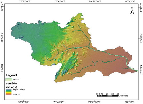
Figure 8. Drainage network of sub-basin I of Palar River with the correspondent rose diagrams of the stream directions of first- (a), second- (b), third- (c), fourth-, fifth-, sixth-, and seventh-order streams and L is the direction of the lineament in the sub-basin I.
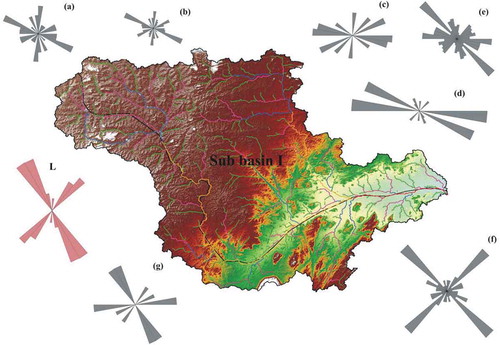
Figure 9. Drainage network of sub-basin I of Palar River with the correspondent rose diagrams of the stream directions of first- (a), second- (b), third- (c), fourth-, fifth-, and sixth-order streams and L is the direction of the lineament in the sub-basin II.
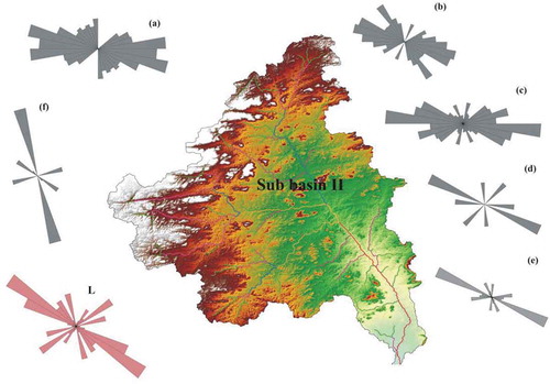
Figure 10. Drainage network of sub-basin I of Palar River with the correspondent rose diagrams of the stream directions of first- (a), second- (b), third- (c), fourth-, fifth-, and sixth-order streams and L is the direction of the lineament in the sub-basin III.
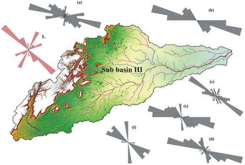
Figure 11. Drainage network of sub-basin I of Palar River with the correspondent rose diagrams of the stream directions of first- (a), second- (b), third- (c), fourth-, fifth-, and sixth-order streams and L is the direction of the lineament in the sub-basin IV.
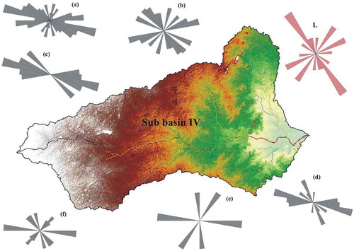
Figure 12. Drainage network of sub-basin I of Palar River with the correspondent rose diagrams of the stream directions of first- (a), second- (b), third- (c), fourth-, fifth-, and sixth-order streams and L is the direction of the lineament in the sub-basin V.
Drainage network and lineaments in relation with neotectonics
The geometry of the drainage network and the trend of lineaments is used to reconstruct the tectonic activity that has changed the landscape. The linkage between lineament and drainage direction helps to understand the relationship between channel orientation and tectonics. The analysis of the stream channels and lineaments demonstrate that some preferential orientations exist which are likely to be tectonically controlled. Direction of the lineaments was quantified for all the sub-basins. In all the five sub-basins first-order to fourth-order streams of the Palar River drains into higher order streams in all directions, though preferential flow in NW-SE and E-W (–). Fifth- and sixth-order streams in the Palar River drainage basin has NE-SW and NW-SE dominant domain. The lineament trend analysis, the rose diagram peaks show in NE-SW and NW-SE direction of lineament trends in all sub-basin, which reveals the pervasive nature of NE-SW, NW-SE trending lineaments. Importance of NE-SW and NW-SE field becomes more important when the streams reach fifth order (–). Within the five sub-basins, two main types of geometric relationship between drainage network and lineaments exist. The “type A” designates the area where the main orientation of the drainage network is the same as the lineaments. A typical instance is that of sub-basin I (). Here, we identified lineaments and faults with a NW-SE orientation (–). The “type B,” is the most recurrent drainage direction and is noted by the orientation of the numerous low-order streams that run perpendicular to the main river channel and to the lineaments. The B-type sub-basin II is an example where the fifth and sixth order is parallel and several second- and third-order channels join the river perpendicularly.
Conclusions
The morphometric analysis using remote sensing and GIS technology coupled with a new visual basic program called bAd proved as an efficient tool for drainage network analysis. The morphometric parameter of linear, areal, and relief characteristics of the Palar River shows the relations between hydrological systems and their associated morphological landforms. The linear arrangement of stream number and stream order reveals the flow direction strictly controlled by external forces. The high bifurcation ratios of the larger order streams along with low form factors implies the geological control of neotectonic activities on the drainage system. All the sub-basins as a result of tectonic activity and erosion on the development of the channel orientation is (i) most channels are directly (A-type) or indirectly (B-type) related to the lineaments, (ii) the pattern of the drainage network is dendritic and rectangular. All these evidence point toward the tectonically uplift-induced drainage system for the Palar River.
Acknowledgments
This study was supported by the Department of Science and Technology, New Delhi, project nos. DST (WOS-A)-SR/WOS-A/ES-34/2012 granted to Resmi M.R. The authors are grateful to the two reviewers for their critical and constructive comments that significantly helped in improving the presentation of the manuscript.
Disclosure statement
No potential conflict of interest was reported by the authors.
Additional information
Funding
References
- Balakrishnan, S., & Rajamani, V. (1987). Geochemistry and petrogenesis of granitoids around the kolar schist belt, South India: Constraints for the evolution of the crust in the kolar area. The Journal of Geology, 95, 219-240. doi:10.1086/629121
- Beneduce, P., Festa, V., Francioso, R., Schiattarella, M., & Tropeano, M. (2004). Conflicting drainage patterns in the matera horst area. southern Italy. Physics and Chemistry of the Earth. Parts A/B/C, 29, 717–724.
- Burbank, D. W., & Anderson, R. S. (2001). Tectonic geomorphology (pp. 270). Oxford: Blackwell Scientific.
- Burrough, P. A., & McDonnell, R. A. (1998). Principles of geographical information systems. New York, NY: Oxford University Press Inc.
- Chorley, R. J., Schumm, S. A., & Sugden, D. E. (1984). Geomorphology (pp. 605). London: Methuen & Co.
- Clarke, J. I. (1966). Morphometry from maps, Essays in geomorphology (pp. 235–274). New York, NY: Elsevier.
- Cox, R. T. (1994). Analysis of drainage basin asymmetry as a rapid technique to identify areas of possible Quaternary tilt-block tectonics: An example from the mississippi embayment. Geological Society of American Bulletin, 106, 571–581.
- Delcaillau, B., Carozza, J. M., & Laville, E. (2006). Recent fold growth and drainage development: The Janauri and Chandigarh anticlines in the Siwalik foothills, northwest India. Geomorphology, 76, 241–256.
- Dinesh, A. C., Markose, V. J., & Jayappa, K. S. (2012). Bearing, azimuth and drainage (bAd) calculator: A new GIS supported tool for quantitative analyses of drainage networks andwatershed parameters. Computer Geoscience, 48, 67–72.
- Evans, I. S. (1984) Correlation structures and factor analysis in the investigation of data dimensionality: Statistical properties of the Wessex land surface, England. In: Proceedings of the Int. Symposium on Spatial Data Handling, Zurich. 1, GeographischesInstitut (pp 98–116). Universitat Zurich-Irchel.
- Gardiner, V. (1990). Drainage basin morphometry. In A. S. Goudie (Ed.), Geomorphological techniques (pp. 71–81). London: Unwin Hyman.
- Hadley, R. F., & Schumm, S. A. (1961) Sediment sources and drainage basincharacteristics in upper Cheyenne River basin. Water Supply Paper 1531-B U.S (pp 137–196). Geological Survey.
- Harvey, C. A., & Eash, D. A. (1996). Description, instructions, and verification for Basin soft, a computer program to quantify drainage basin characteristics, U.S. Geologic Survey Water Resources Investigations Report, 25, 95–4287.
- Hodgkinson, J. H., McLoughlin, S., & Cox, M. (2006). The influence o geological fabric and scale on drainage pattern analysis in a catchment of metamorphic terrain: Laceys Creek, southeastQueenland, Australia. Geomorphology, 81, 394–407.
- Horton, R. E. (1932). Drainage basin characteristics. American Geophys Union Transactions, 13, 348–352.
- Horton, R. E. (1945). Erosional development of streams and their drainage basins: Hydro-physical approach to quantitative morphology. Geological Society of American Bulletin, 56, 275–370.
- Kaliraj, S., Chandrasekar, N., & Magesh, N. S. (2014). Morphometric analysis of the River Thamirabarani sub-basin in Kanyakumari District, South west coast of Tamil Nadu, India, using remote sensing and GIS. Environmental Earth Science. doi:10.1007/s12665-014-3914
- Lin, W. T., Chou, W. C., Lin, C. Y., Huang, P. H., & Tsai, J. S. (2008). Win basin: Using improved algorithms and the GIS technique for automatedwatershed modeling analysis from digital elevation models. International Journal of Geographical Information Science, 22(1), 47–69.
- Lupia, P. E., Centamore, E., Ciccacci, S., D’Alessandro, L., Monte, D. M., Fredi, P., & Pugliese, F. (1998). Geomorfologia quantitativa e morfodinamica del territorioabruzzese: II – Ilbacinoidrografico del Fiume Tordino. Geografia Fisica e DinamicaQuaternaria, 21, 113–129.
- Magesh, N. S., & Chandrasekar, N. (2012). GIS model-based morphometric evaluation of Tamiraparanisub-basin, Tirunelveli district, Tamil Nadu, India. Arabian Journal of Geoscience, 7(1), 131–141.
- Magesh, N. S., Chandrasekar, N., & Soundranayagam, J. P. (2011). Morphometric evaluation of Papanasam and Manimuthar watersheds, parts of Western Ghats, Tirunelveli district, Tamil Nadu, India: AGIS approach. Environmental Earth Science, 642, 373–381.
- Mahmood, S. A., & Gloaguen, R. (2012). Appraisal of active tectonics in Hindu Kush: Insights from DEM derived geomorphic indices and drainage analysis. Geoscience Frontiers, 3, 407–428.
- Majumdar, J. P. (1982). Morphometric analyses of the 4th order drainage watersheds of the Khowai river basin, Tripura, India—Some preliminary results and observations. Journal Indian Society of Remote Sensing, 10(3), 49–53.
- Markose, V. J., Dinesh, A. C., & Jayappa, K. S. (2014). Quantitative analysis of morphometric parameters of Kali River basin, southern India, using bearing azimuth and drainage (bAd) calculator and GIS. Environmental Earth Science. doi:10.1007/s12665-014-3193-x
- Merritts, D., & Vincent, K. R. (1989). Geomorphic response of coastal streams to low, intermediate, and high rates of uplift, Mendocino junction region, northern California. Geological Society of American Bulletin, 101, 1373–1388.
- Muller, J. E. (1968). An introduction to the hydraulic and topographic sinuosity indexes. Annals of the Association of American Geographers, 58, 371–385.
- Nag, S. K., & Chakraborty, S. (2003). Influence of rock types and structures in the development of drainage network in hard rock area. Journal Indian Society of Remote Sensing, 31(1), 25–35.
- Nautiyal, M. D. (1994). Morphometric analysis of a drainage basin, district Dehradun, Uttarpradesh. Journal Indian Society of Remote Sensing, 22(4), 251–261.
- Oguchi, T. (1997). Drainage density and relative relief in humid steep mountains with frequent slope failure. Earth Surface Process and Land Forms, 22, 107–120.
- Ozdemir, H., & Bird, D. (2009). Evaluation of morphometric parameters of drainage networks derived from topographic maps and DEM inpoint floods. Environmental Geology, 56, 1405–1415.
- Pakhmode, V., Kulkarni, H., & Deolankar, S. B. (2003). Hydrological drainage analysis in watershed programme planning: A case study from the Deccan basalt, India. Hydrogeology Journal, 11, 595–604.
- Patton, P. C. (1988). Drainage basin morphometry and floods. In V. R. Baker, R. C. Kochel, & P. C. Patton (Eds.), Flood geomorphology (pp. 51–65). New York, NY: Wiley.
- Pérez-Peña, J. V., Azor, A., Azañon, J. M., & Keller, E. A. (2010). Active tectonics in the sierra Nevada (Betic cordillera, SE Spain): Insights from geomorphic indexes and drainage pattern analysis. Geomorphology, 119, 74–87.
- Pophare, A. M., & Balpande, U. S. (2014). Morphometric analysis of Suketi River basin, Himachal Himalaya, India. Journal Earth System Science, 123(7), 1501–1515.
- Rai, P. K., Mohan, K., Mishra, S., Ahmad, A., & Mishra, V. N. (2014). A GIS-based approach in drainage morphometric analysis of Kanhar River Basin, India. Applied Water Science. doi:10.1007/s13201-014-0238-y
- Ramasamy, S. M., Kumanan, C. J., Selvakumar, R., & Saravanavel, J. (2011). Remote sensing revealed drainage anomalies and related tectonics of South India. Tectonophysics, 501, 41–51.
- Resmi, M. R., Achyuthan, H., & Jaiswal, M. K. (2017). Middle to late Holocene paleochannels and migration of the Palar River, Tamil Nadu- Implications of neotectonic activity. Quaternary International, 443, 211–222.
- Ribolini, A., & Spagnolo, M. (2008). Drainage network geometry versus tectonics in the Argentera Massif (French–Italian Alps). Geomorphology, 93, 253–266.
- Schumm, S. A. (1956). Evolution of drainage systems and slopes in badlands at Perth Amboy, New Jersey. Geological Society of America Bulletin, 67, 597–646. doi:10.1130/0016-7606(1956)67[597:EODSAS]2.0.CO;2
- Schumm, S. A. (1963). Sinuosity of alluvial rivers in the great plains. Bulletin of Geological Society of America, 74, 1089–1100.
- Schumm, S. A. (1986). Alluvial river response to active tectonics. In study in geophysics (pp. 80-94). Washington DC: National Academy Press.
- Seta, D. M., Monte, D. M., & Pascoli, A. (2005). Quantitative geomorphic analysis to evaluate flood hazards. Geografia Fisicae Dinamica Quaternaria, 28, 117–124.
- Shahzad, F., & Gloaguen, R. (2011a). TecDEM: A MATLAB based toolbox for tectonic geomorphology, part 1: Drainage network preprocessing and stream profile analysis. Computer and Geoscience, 37, 250–260.
- Shahzad, F., & Gloaguen, R. (2011b). TecDEM: A MATLAB based toolbox for tectonic geomorphology, part 2: Surface dynamics and basinanalysis. Computer and Geoscience, 37, 261–271.
- Smith, S. (1950). Standards for grading textures of erosionaltopography. American Journal of Science, 248, 655–668.
- Sreedevi, P. D., Subrahmanyam, K., & Ahmed, S. (2005). The significance morphometric analysis for obtaining groundwater potential zones in structurally controlled terrain. Environmental Geology, 47, 412–420.
- Strahler, A. N. (1952). Hypsometic (area-altitude) analysis of erosional topography. Bulletin of Geological Society of America, 63, 1117–1142.
- Strahler, A. N. (1957). Quantitative analysis of watershed geomorphology. Transactions, American Geophysical Union, 38, 913–920.
- Strahler, A. N. (1964). Quantitative geomorphology of drainage basin and channel networks. In V. T. Chow (Ed.), Handbook of appliedhydrology (pp. 4–76). NewYork, NY: Mc Graw Hill Book Co.
- Subramanya, K. R. (1996). Active intraplate deformation in south India. Tectonophysics, 262, 231–241.
- Thomas, J., Joseph, S., Thrivikramji, K. P., Abe, G., & Kannan, N. (2012). Morphometrical analysis of two tropical mountain river basins of contrasting environmental settings, the southern Western Ghats, India. Environmental Earth Science, 66(8), 2353–2366.
- Vaidyanathan, R. (1971). Evolution of the drainage of Cauvery in south India. Journal of the Geological Society of India, 12, 14–25.
- Van der Beek, P., Champel, B., & Mugnier, J. L. (2002). Control of detachment dip on drainage development in regions of active fault propagation folding. Geology, 30, 471–474.
- Verstappen, H. (1983). The applied geomorphology. In InternationalInstitute for aerial survey and earth science (ITC). Ensched.