
 ?Mathematical formulae have been encoded as MathML and are displayed in this HTML version using MathJax in order to improve their display. Uncheck the box to turn MathJax off. This feature requires Javascript. Click on a formula to zoom.
ABSTRACT
Landslide catastrophe happen on 30 July 2014 has buried almost 140 peoples under a loose soil mass in Malingaon village of Pune district, Maharashtra, India. Soil samples from a hill slope sections were collected (viz. bottom, middle, and top) for determination of the soil properties and slope stability. Mainly excess rainfall triggered the land slide, which directly affected on geotechnical properties of soil. The results showed that the hill slope was unstable with factor of safety less than one and which is prone to failure. The land use and land cover map (viz. before and after of land slide) analysis have inferred that the hill slope was unstable. The unscientific way of agriculture practices method and conversion of nonagricultural land into agricultural usage was the major cause for land slide in the study area. This study provides a technically viable solution method to avoid such disaster in same topographical features.
1. Introduction
Landslide is a common natural disaster often in hilly terrain, which causes huge loss of natural resources and human life (Ering & Babu, Citation2016). It is mainly attributed by natural factors, such as earthquakes and rainfall occurred on these regions (Collins & Znidarcic, Citation2004; Rahardjo, Li, Toll, & Leong, Citation2001). A sudden downward movement of the consolidated, unconsolidated soils, and rock matter from a geomorphic feature due to natural and man-made activities leads to landslide (Patil & Gopale, Citation2018). Such movement can occur in many ways, it can be a fall, topple, slide, spread, or flow (Ering & Babu, Citation2016). The hypothesis for land slide was rain water infiltration decreases metrics suction (i.e., negative pore water pressure) in the soil, which results in decrease of shear strength and trigger the landslide phenomenon in hilly terrian (Fredlund & Rahardjo, Citation1993).
In 2008, Wenchuan earthquake happened in China that caused more than 15,000 geohazards in the form of landslides, rock falls, and debris flows, which resulted in about 20,000 peoples death (Yin, Wang, & Sun, Citation2009). Cho (Citation2014) has performed probabilistic slope stability and seepage analyses method to determine the effects of spatial variability on the slope stability and mean discharge. It was found that weak correlation increases uncertainty in the sampled soil properties. Other examples include over steepening of slopes by undercutting the bottom and loading the top of a slope to exceed the bearing strength of the soil or other component material. Populations expanding onto new lands, which convert the agricultural land into non-agricultural land, causes shortage of agricultural land. Landslides may also occur on stable areas due to other human activities such as irrigation, lawn watering, draining of reservoirs (or creating them), leaking pipes, and improper excavating or grading on hill slopes. Eventually, these areas discourage many habitants to live and use sloping land for agricultural productivity (Singh et al., Citation2016).
In total 15% or 0.49 million km2 of the terrain in India are susceptible to landslide are prone to landslide (Walde et al., Citation2017). The most affected parts of landslide in India are Himalayas, Westerns Ghats, Nilgris, and Vindhyas (Chandrasekaran, Elayaraja, & Renugadevi, Citation2013; Mahanta, Sathe, & Mahagaonkar, Citation2016; Ramakrishnan, Singh, Verma, Gulati, & Tiwari, Citation2012; Sathe, Goswami, & Mahanta, 2019; Sathe et al., 2019; Sathe, Mahanta, & Mishra, Citation2018; Thennavan, Ganapathy, Sekaran, & Rajawat, Citation2016; Vasantha Kumar & Bhagavanulu, Citation2008; Wadhawan, Citation2018). On the basis of landslide hazard map of states of India, like Sikkim and Mizoram, have found that they are falling under very high to severe hazard classes (Punmia and Jain Citation1970). In the Indian peninsular region, the hilly states like Karnataka, Andhra Pradesh, and Kerala constitute low to moderate hazard prone areas (Ramesh, Citation2017). The western ghat of Maharashtra is an integral part of Indian peninsular region contains varying topographical features, such as mountains, hill locks, seasonal and perennial rivers, lakes, and ponds.
On 30 July 2014, a landslide occurred in the village of Malingaon, Maharashtra, India caused by a burst of heavy rainfall, killed 151 peoples and damaging 45 houses (Ering, Kulkarni, Kolekar, Dasaka, & Babu, Citation2015). In the current scenario, there are different methods such as conventional soil testing and numerical methods existing to study the landslide and slope stability (Palma, Parise, Reichenbach, & Guzzetti, Citation2011; Ramakrishnan et al., Citation2012; Sarkar, Kanungo, Patra, & Kumar, Citation2008; Singh et al., Citation2016). This study focused on following objectives: (1) identify the typical hill slope parameters and valuranable soil properties; (2) application of Arc GIS for identification of vulnerability of hill slope failure; (3) suggest preventive measures to avoid landslide.
2. Site description
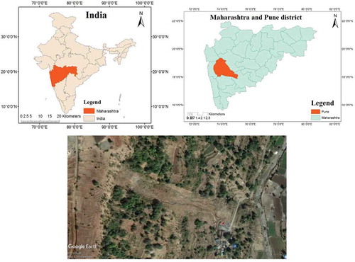
Malingaon village is located in Ambegaon taluka of Pune district, Maharashtra state, India. It is located at 786 m ground elevation and about 95 km away from Pune city. Geographical co-ordinates of the village are N 19°09ʹ34.4″ and E 73°41ʹ19″ (). In last decade (i.e., 2003 to 2012) average rainfall recorded in Ambegaon taluka was 81 cm (CGWB, Pune 2013). This enough rainfall and availability of water in this area have encouraged many peoples to practice agriculture activity. The study area bounded on the eastern side by a seasonal tributary of Ghod river. This agriculturally productive land near hill slope produces economically source to the poor villager’s living in this study area. Around 70 dwelling units existed before landslide. The hill slopes were partially converted for paddy cultivation and agricultural land by the local villagers. The geology of Malingaon village is mainly comprised by the basaltic strata (Singh et al., Citation2016). The topographic map of the area shows had an evidenced of two low magnitudes seismic activities (4.0–4.9) within 100 km radius of the landslide location. However, these seismic events do not appear to have played any significant role in inducing slope instability in Malingaon.
Figure 1. Study area map location of Malingaon with respect to India and Maharashtra. It also shows present topography of Malingaon in Pune district
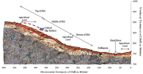
The entire hill slope has divided into four zones: Zone 1: from the seasonal tributary to the road level, which was relatively flatter in its lower part followed by gentle slope in upper part. Zone 2: from road level to the 2nd slope level, this was relatively gentler. Zone 3: from 2nd major slope level to the 3rd major slope break, this was moderately inclined. Zone 4: from 3rd level till the apex of the hill, this was moderately inclined. The top level i.e., zone 4 slope inclination was measured from the base topographic map is around 35°. Considering the similarity of slope configuration for the entire Malingaon hill slope, a longitudinal section was drawn to the southern side of the hill from across the river up to just above the crown level of Malingaon landslide (). This section roughly reveals the pre-slide slope configuration of slide portion. shows the longitudinal topographical section along line of the slope.
Figure 2. Cross section of Malingaon hill, showed a critical three zones of land slide and gradient study area
3. Features of the Malingaon landslide
The height of the landslide is roughly estimated as 180 m while the width of the slide varies from 40 to 132 m. The entire length of the slide from the crown to toe is 512 m and the area affected is 44,239 m2. The crown of the landslide is at a height of 930 m and marks the top of 4th zone. The width of the landslide in this zone varies from 40 to 132 m. The landslide depleted part of 4th zone, entire 3rd zone and maximum part of 2nd zone. Lowest part of 2nd zone and 1st zone form the zone of accumulation, this zone of accumulation is the settlement area of the Malingaon village. The maximum thickness of the material slided during landslide could not be established accurately and it is approximated as 7 m because when the detailed mapping work was carried out, most of the failed slope material has been removed from the place as part of rescue effort.
4. Material and methods
4.1. Field test
During field visit to Malingaon, selective field test were carried out on soil samples such as thumb penetration, core cutter, and slope angle by abney level. For analytical method analysis, representative undisturbed core soil samples from four zones of hill slope were collected for identifying geotechnical parameters in a laboratory.
4.2. Analytical methods
The Plasticity Index (PI) is a measure of the plasticity of a soil. The PI is the difference between the liquid limit and the plastic limit (PI = LL – PL). Soils with a high PI tend to be clay, those with a lower PI tend to be silt, and those with zero value indicate non-plasticity and tends to have little or no silt or clay content.
Plasticity index = liquid limit – plastic limit
Soil descriptions based on PI:
0 – Non-plastic, < 7 – Slightly plastic, 7–17 – Medium plastic, > 17 – Highly plastic
4.3. Direct shear test
It is laboratory test used for determination of shear strength properties of soil. This test is performed on three specimens of relatively undisturbed collected soil samples. A confining stress was applied vertically to the specimen and the upper ring is pulled laterally until sample was failed. Applied load and proving ring reading was used to find the “C” and “ɸ” values, after that factor of safety (FOS) at top hill for an infinite slope under steady seepage condition during heavy rainfall was calculated by following equation (Punmia and Jain Citation1970):
Where ɸ = internal friction of soil in degree
i = Original slope angle of hill in degree
C = Cohesion in kg/cm2
ץ’ = Submerged unit weight of soil in kg/cm3
ץsat = Saturated unit weight of soil in kg/cm3
4.4. Land use land cover
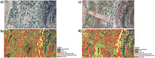
Google earth Pro 2018 version was used for interpretation of land use and land cover map. Image was registered in Arc GIS 9.1 software (UTM 1983 and datum WGS84). Individual bands of digital data were imported into the image processing software also the noise renewal and enhancement was performed prior to the analysis. False Color Composite (FCC) was performed from making observation on the individual bands for blue, green, and red combination. The precise interpretation of various land use and land cover for the study area map was performed by supervised classification method in Arc GIS software. Land use and land cover classes were classified insight categories viz., tress, losses soil with hard rock, paddy land, artificial agricultural land, loses soil, exposed hard rock.
5. Result and discussion
5.1. Field test
The Thumb penetration, core cutter test was conducted. It was observed that the thumb penetrated easily, which indicates that the top soil is sandy-clay. Similarly, in core cutter test indicates that the average dry density of top, middle, and bottom of the soil was 1.2 g/cc, 1.4 g/cc, and 1.3 g/cc respectively (). According to United States Department of Agriculture, soil was texturally classified, the soil at the top, middle, and bottom was a sandy-clay, silty clay, and silty clayey loam, respectively. Crumble test indicated that pressure required to crumble the soil was negligible, which supports the core cutter test results. The field observation such as on top of the hill, the unplanned land was used for rice crop plantation in rainy season. Using abney level, we have measured average slope angle for hill from bottom to top, which was recorded as 35 (35 degree angle).
Table 1. Results of soil properties
5.2. Geotechnical parameters
Specific gravity, water content, liquid limit, plastic limit, and PI test results are shown in . The average specific gravity of representative soil sample from top, middle, and bottom were recorded as 2.3, 2.2, and 2.4 suggested that it contains high amount of sand particle whereas water content results classified it as sandy-clayey soil (Sathe, S. S., & Mahanta, C. Citation2019). Other parameters of soil such as liquid limit and plastic limit results showed that liquid limit was higher than the plastic limit in all representative soil samples, which further indicate that top soil required less water content to achieve a liquid limit and plastic limit comparative to bottom hill soil. Similarly, PI results further indicates that the quick attendance of liquid limit of top soil than the bottom hill soil sample. These results clearly showed that the top and middle hill slope soil was unstable and vulnerable for liquid state ().
Table 2. Field test results for three regions on hill slope
5.3. Shear strength parameters of soil samples
The results of internal friction angle and un-drained cohesion of representative soil samples were determined. It has observed that the FOS for infinite slope is less than one, so that the slope of hill was unstable during heavy rainfall where seepage was parallel to the slope. The preliminary conclusion was drawn from the experimental reading that resisting force created by soil is less than driving force and hence slope unstable. shows that the shear strength parameters for representative soil samples was observed decreasing from hill top to hill bottom, which suggest that punching shear failure can occurs at the bottom and middle section of hill.
5.4. Land use land cover
Land use and land cover map of the region showed that the previous scenario and after land slide scenario of the study area. The map shows six color category namely exposed rock, trees, losse soil, paddy agricultural land, developed agricultural land, and hard rock ()). The patches of red and green color on the middle (i.e., zone 2) and top zone (i.e., zone 4 and 3) indicates the formation artificial land over the hill for agricultural purposes by the villagers. Therefore, it has developed a large volume of loose soil ()). The second scenarios of the study area clearly showed the mass strip of loosen soil drawn at foot hill by the natural disaster, which was used to predicate the future land slide zone in similar topographical study area ()).Drainage system throughout the hill slope was not observed.
Figure 3. Land use land cover map of Malingaon before occurrence of landslide in year 2014 (a and b). Land use land cover map of Malingaon after occurrence of landslide in year 2014 (c and d)
6. Conclusion
Hill slope monitoring is essential to avoid such landslide near habitants area. Seriousness about the land slide and its effect on habitant should be properly conveyed to such type of topographical regions which is very important to create an awerness amongest the people. The main cause for hill slope failure was an improper drainage system at the top and middle part of the hill, which have created a more pore water pressure in respective sections. The other major factors for landslide in this area was unplanned agricultural land creation and deforestation which was inferred from land use and land cover map. The results of soil analysis indicate that FOS is less than one (i.e., < 1) which suggest that slope is unstable and supported by internal friction angle results for the respective zone tested soil. The land use and land cover analysis of topographical map have delineated the vulnerable zone. Land use and land cover by Arc GIS software would help to identify the topographical susceptible zones for landslide.It further suggests the possible location of artificial drainage network system of such vulnerable zone which can accommodate the excess surface water and safely discharge into adjoining tributaries. Soil erosion is also the causative factor; this can be reduced by increasing the vegetative growth on the sloping areas. Necessity of awareness about the changing agricultural practices as well as controlling the human activities leads to cause landslide.
Highlights
Identification of causes for landslide
Slope stability parameters analysis
Land use and land cover map method
Preventive measures for landslide
Future Studies
For the current study stability of slope is carried out by estimating FOS with respect to geotechnical properties of soil and slope angle of hill in Malingaon. Land use and land cover by arc GIS is used to identify the various causes of landslide, further this work is carried out to identify such villages having same situation like Malingaon, and suggest some preventive techniques to avoid occurrence of such type of landslide in future. Use different techniques to identify stability of slope such as finite element method, GIS, GPS Techniques, etc., in this present study seepage analysis were not determined for accurate results further work on seepage is essential. In the present study, only three samples each (Top, Middle, and Bottom) of failure slope is collected to determine geotechnical properties of soil, it is further suggested to collect more soil samples for identifying geotechnical properties of soil will increase accuracy of results.
Acknowledgments
The authors thank department of civil engineering, Annasaheb Dange College of Engineering and Technology, Ashta, affiliated to Shivaji University, Kolhapur, Maharashtra for providing the necessary facilities to carry out this research work. Authors gratefully acknowledge the Mrs. Sunita Mane gram-panchayat of Malingaon for her assistance and sharing data used for this study. The authors would also like to acknowledge the two reviewers and the editor for their helpful comments on the earlier version of the manuscript. This research did not receive any specific grant from funding agencies in the public, commercial, or not-for-profit sectors.
Disclosure statement
No potential conflict of interest was reported by the authors.
Correction Statement
This article has been republished with minor changes. These changes do not impact the academic content of the article.
References
- Chandrasekaran, S. S., Elayaraja, S., & Renugadevi, S. (2013). Damages to transport facilities by rainfall induced landslides during November 2009 in Nilgiris, India. Landslide Science and Practice, (Vol. 2, pp 171–176).
- Cho, S. E. (2014). Probabilistic stability analysis of rainfallinduced landslides considering spatial variability of permeability. Engineering Geology, 171, 11–20.
- Collins, B. D., & Znidarcic, D. (2004). Stability analyses of rainfall induced landslides. Journal of Geotechnical and Geoenvironmental Engineering, 130(4), 362–372.
- Ering, P., & Babu, G. S. (2016). Probabilistic back analysis of rainfall induced landslide‐A case study of Malin landslide, India. Engineering Geology, 208, 154–164.
- Ering, P., Kulkarni, R., Kolekar, Y., Dasaka, S. M., & Babu, G. S. (2015). Forensic analysis of Malin landslide in India. In IOP Conference Series: Earth and Environmental Science,Warwick,UK (Vol. 26, No. 1, pp. 012040). IOP Publishing
- Fredlund, D. G., & Rahardjo, H. (1993). Soil mechanics for unsaturated soils. New York, NY: John Wiley& Sons.
- IS 2720-1985: Part 13 direct shear test, Indian Standard methods of test for soils
- IS 2720-1985: Part 5 determination of liquid and plastic limit, Indian Standard methods of test for soils
- IS 2720-1985: Part 7&8 determination of water content-dry density relation using light compaction, Indian standard methods of test for soils
- IS2720-1985: Part-3 determination of specific gravity, Indian standard methods of test for soils
- Mahanta, C., Sathe, S. S., & Bhattacharya, P. (2012) Grain size, mineralogy and sediment composition as factors controlling release and mobilization of arsenic in parts of the Brahmaputra floodplains, northeastern India. GSA annual meeting in Charlotte.
- Mahanta, C., Sathe, S. S., & Mahagaonkar, A. (2016, June 19–23). Morphological and mineralogical evidences of arsenic release and mobilization in some large floodplain aquifers. In Arsenic research and global sustainability: Proceedings of the Sixth International Congress on Arsenic in the Environment (As2016) (pp. 66). Stockholm, Sweden: CRC Press.
- Palma, B., Parise, M., Reichenbach, P., & Guzzetti, F. (2011). Rockfall hazard assessment along a road in the Sorrento Peninsula, Campania, southern Italy. Natural Hazards, 61(1), 187–201.
- Patil, V., & Gopale, R. (2018). A geographical study of landslide: A case study of malin village of ambegaon tahsil in pune district, Maharashtra. Peer Reviewed International Research Journal of Geography, 35, 55–60.
- Punmia, B. C., & Jain, A. K. (1970). Soil mechanics and foundations (16th ed.). New Delhi: Laxmi publication (P) Ltd.
- Rahardjo, H., Li, X. W., Toll, D. G., & Leong, E. C. (2001). The effect of antecedent rainfall on slope stability. Geotechnical and Geological Engineering, 19(3/4), 371–399.
- Ramakrishnan, D., Singh, T. N., Verma, A. K., Gulati, A., & Tiwari, K. C. (2012). Soft computing and GIS for landslide susceptibility assessment in Tawaghat area, Kumaon Himalaya, India. Journal of the International Society for the Prevention and Mitigation of Natural Hazards, 65(1), 315–330.
- Thambidurai, p. (2017). Slope stability investigation of chandmari in Sikkim, Northeastern India. In Workshop on world landslide Forum (pp. 363–369). Cham: Springer.
- Sarkar, S., Kanungo, D. P., Patra, A. K., & Kumar, P. (2008). GIS based spatial data analysis for landslide susceptibility mapping. Journal of Mountain Science, 5(1), 52–62.
- Sathe, S. S., Goswami, L., & Mahanta, C. (2019). Integrated factors controlling arsenic mobilization in an alluvial floodplain. Environmental Technology & Innovation. ETI 100525, Vol. 17C. doi:10.1016/j.eti.2019.100525
- Sathe, S. S., & Mahanta, C. (2019). Groundwater flow and arsenic contamination transport modeling for a multi aquifer terrain: Assessment and mitigation strategies. Journal of Environmental Management, 231, 166–181.
- Sathe, S. S., Mahanta, C., & Mishra, P. (2018). Simultaneous influence of indigenous microorganism along with abiotic factors controlling arsenic mobilization in Brahmaputra floodplain, India. Journal of Contaminant Hydrology, 213, 1–14.
- Singh, T. N., Singh, R., Singh, B., Sharma, L. K., Singh, R., & Ansari, M. K. (2016). Investigations and stability analyses of Malin village landslide of Pune district, Maharashtra, India. Journal of the International Society for the Prevention and Mitigation of Natural Hazards, 81(3), 2019–2030.
- Thennavan, E., Ganapathy, G. P., Sekaran, S. C., & Rajawat, A. S. (2016). Use of GIS in assessing building vulnerability for landslide hazard in The Nilgiris, Western Ghats,India. Journal of the International Society for the Prevention and Mitigation of Natural Hazards, 82(2), 1031–1050.
- Vasantha Kumar, S., & Bhagavanulu, D. V. S. (2008). Effect of deforestation on landslides in Nilgiris district — A case study. Journal of the Indian Society of Remote Sensing, 36(1), 105–108.
- Wadhawan, S. K. (2018). Landslide susceptibility mapping, vulnerability and risk assessment for development of early warning systems in India. Advances in Natural and Technological Hazards Research, 50,145–172.
- Walde, S., Kale, K., Kundu, S., Nagaraj, P., Shelar, T., & Shukla, V. K. (2017). GIS based landslide susceptibility assessment of malin area: A case study in watershed, India. 17th Esri India user Conference 2017, New Delhi.
- Yin, Y., Wang, F., & Sun, P. (2009). Landslide hazards triggered by the 2008 Wenchuan earthquake, Sichuan, China. Journal of the International Consortium on Landslides, 6(2), 139–152.